TopoNav: Topological Navigation for Efficient Exploration in Sparse Reward Environments
Abstract
Autonomous robots exploring unknown areas face a significant challenge: navigating effectively without prior maps and with limited external feedback. This challenge intensifies in sparse reward environments, where traditional exploration techniques often fail. In this paper, we introduce TopoNav, a novel framework that empowers robots to overcome these constraints and achieve efficient, adaptable, and goal-oriented exploration. TopoNav’s fundamental building blocks are active topological mapping, intrinsic reward mechanisms, and hierarchical objective prioritization. Throughout its exploration, TopoNav constructs a dynamic topological map that captures key locations and pathways. It utilizes intrinsic rewards to guide the robot towards designated sub-goals within this map, fostering structured exploration even in sparse reward settings. To ensure efficient navigation, TopoNav employs the Hierarchical Objective-Driven Active Topologies framework, enabling the robot to prioritize immediate tasks like obstacle avoidance while maintaining focus on the overall goal. We demonstrate TopoNav’s effectiveness in simulated environments that replicate real-world conditions. Our results reveal significant improvements in exploration efficiency, navigational accuracy, and adaptability to unforeseen obstacles, showcasing its potential to revolutionize autonomous exploration in a wide range of applications, including search and rescue, environmental monitoring, and planetary exploration.
Index Terms:
Topology, Navigation, Sparse Reward, Reinforcement LearningI Introduction
Autonomous navigation in unknown and dynamic environments remains a formidable challenge in robotics. Traditional navigation systems heavily rely on pre-existing maps or continuous feedback from the environment. However, in many real-world scenarios, such as disaster response or extraterrestrial exploration, these resources are often unavailable or unreliable [1, 2]. Typically, such a map is either topological or metric. While metric maps are often reconstructed by optimizing geometric constraints between landmarks and sensor poses with classic simultaneous localization and mapping (SLAM), topological maps have recently attracted attention in visual navigation tasks due to the simplicity, flexibility, scalability, and interpretability [3]. In comparison to metric maps, topological maps serve as a more efficient tool for planning and are also utilized by mammals for navigating through space. RL-based navigation approaches [4], have been used for robot navigation in crowded scenes with dynamic obstacles. However, they are mostly limited to navigation on flat surfaces and do not account for outdoor sparse reward environments. To address this limitation, in this paper, we propose TopoNav, a framework designed to overcome the limitations of current methods in sparse reward environments. TopoNav integrates dynamic topological mapping with a hierarchical objective-driven approach, supported by advanced RL techniques. This framework constructs an active map as the robot explores, identifying key locations and potential paths. The hierarchical system within TopoNav prioritizes objectives, allowing the robot to navigate effectively by balancing short-term tasks, such as obstacle avoidance, with long-term exploration goals. TopoNav also employs intrinsic rewards to foster exploration, addressing the issue of sparse external feedback. By providing internal incentives for reaching sub-goals, TopoNav encourages thorough exploration, enhancing the robot’s understanding of its environment. This approach not only improves navigation efficiency but also adapts to changes in the environment, making it highly suitable for complex, real-world applications.
We evaluate TopoNav in simulated environments that replicate real-world conditions, demonstrating its superiority over traditional methods in terms of exploration efficiency, navigational accuracy, and adaptability [3, 5]. The results indicate that TopoNav offers a significant advancement in autonomous robotic exploration, with potential applications extending to various fields, including search and rescue, environmental monitoring, and space exploration [6, 7]. Our key contributions are as follows:
-
•
Active Topological Mapping: We propose an active topological mapping approach where the robot progressively builds a map with nodes representing key locations and edges denoting navigable paths. This map is continuously updated as the robot explores, enabling efficient path planning and adaptation to environmental changes.
-
•
Intrinsic Rewards for Structured Exploration: In sparse reward environments, reaching sub-goals within the map triggers intrinsic rewards, guiding the robot towards a thorough and structured exploration strategy. This alleviates the need for pre-defined reward functions, making TopoNav applicable to diverse and unpredictable environments.
-
•
Hierarchical Objective Prioritization: Hierarchical Objective Prioritization enables TopoNav to prioritize immediate tasks like obstacle avoidance while keeping the final goal in sight. This hierarchical objective system ensures focused and efficient exploration, preventing the robot from getting sidetracked by irrelevant distractions.
-
•
Experimental Validation of Superior Performance: We evaluate TopoNav in diverse simulated environments, showcasing its superior performance compared to established baselines like PPO and TRPO. Our results demonstrate TopoNav’s ability to achieve faster completion times, higher success rates in challenging scenarios, and efficient online adaptation to dynamic environments.
II Related work
In this section, we discuss existing work on robot navigation with topological mapping.
II-A Metric Map-based Navigation
Metric maps, with their detailed spatial granularity, remain paramount for tasks demanding pinpoint accuracy. Recent works augment this precision with the power of deep learning. Deep SLAM frameworks [8] harness convolutional neural networks (CNNs) to extract landmarks and features from camera data, leading to robust and scalable metric map construction. This enhanced perception empowers robots to navigate complex environments with unprecedented accuracy. Moreover, uncertainty-aware exploration with deep Gaussian processes [9] integrates metric maps with probabilistic modeling, allowing robots to prioritize areas with high information gain potential, balancing exploration and exploitation effectively. Deep reinforcement learning also finds its place in metric-based exploration, with spatial memory-based deep Q-learning [10] enabling robots to learn an exploration policy that prioritizes novel areas while navigating efficiently. However, despite these advancements, the computational demands and sensitivity to sensor errors inherent in metric maps remain demanding concerns.
II-B Topological Mapping in Robot Navigation
The use of topological maps for robotic exploration and navigation has gained significant advancements due to their efficiency, adaptability, and robustness to limited information [3, 5]. Existing approaches leverage diverse sensor modalities like RGB images, depth maps, poses, and LiDAR scans to build these maps [11]. Some employ data-intensive reinforcement learning (RL) techniques for map construction, often in conjunction with imitation learning, leading to accurate but computationally expensive models [12]. However, their dependence on metric information and reliance on large datasets limit their applicability in sparse reward environments [11]. Random walk approaches offer a simpler solution, but they often result in inefficient map exploration.
II-C Hybrid Map-based Navigation
Hybrid maps, seeking to synergize the strengths of both metric and topological representations, continue to evolve. Metric-topological co-SLAM [13] proposes a framework that simultaneously builds both metric and topological maps, enabling concurrent localization, mapping, and exploration, particularly beneficial for dynamic environments. Learning hybrid maps with differentiable neural rendering [14] utilizes differentiable neural rendering to create a hybrid map that combines metric and topological representations. This allows robots to efficiently generate panoramic views and plan paths within the map. Finally, exploration with learned hybrid map representations combines metric maps with learned latent topological representations. This empowers robots to plan fine-grained motions using the metric map while utilizing the topological representation for efficient exploration across large areas. However, efficient algorithms for data fusion and integration remain crucial challenges within the hybrid map domain.
TopoNav, our proposed framework, overcomes some of the limitations of existing approaches by embracing intrinsic rewards and dynamic awareness. It constructs and dynamically updates a lightweight topological map, guiding the robot towards designated sub-goals within this map even in environments with sparse external rewards. This structured exploration is driven by intrinsic motivations while remaining focused on the overall objective through a hierarchical objective-driven approach. This combination leads to efficient exploration, adaptability to dynamic environments, and robustness to delayed or absent external rewards, paving the way for successful robot navigation in diverse and challenging contexts.
III Problem Formulation
The primary challenge addressed by TopoNav is to navigate and explore efficiently in environments where the reward structure is sparse and feedback is minimal. The formulation of this problem involves constructing a mathematical model that captures the dynamics of the environment, the robot’s sensory inputs, and the decision-making process.
III-A Environment and State Space
The environment is represented as a state space , where each state encapsulates the robot’s perception of its surroundings. This includes positional data, sensory inputs, and any relevant environmental features.
III-B Topological Map Construction
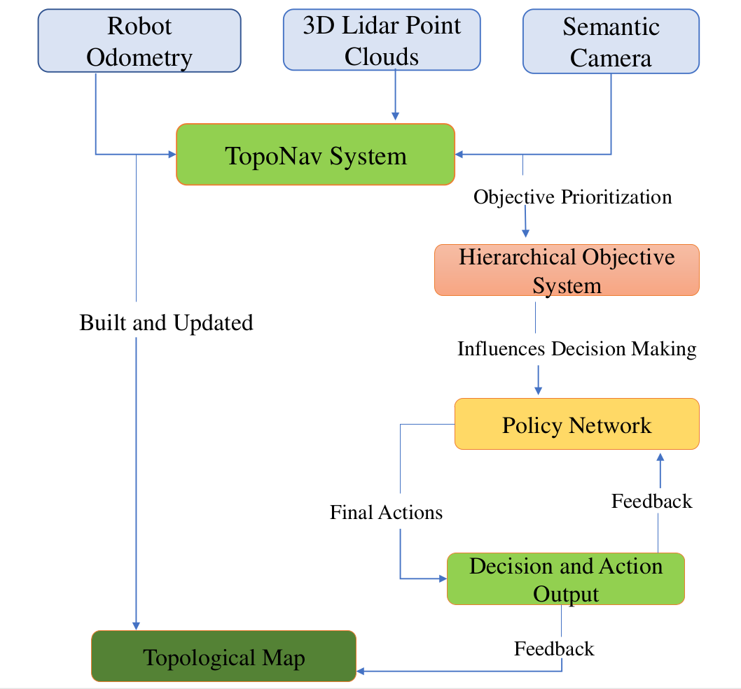
TopoNav constructs a topological map , where represents nodes correspTopoNavonding to significant locations or features, and represents edges denoting navigable paths. Each node is associated with a feature vector derived from the robot’s sensors. Edges are established based on a connectivity function , dependent on factors like proximity and visibility.
III-C Hierarchical Objective System
A hierarchical objective system is employed to prioritize goals based on their relevance to the current state and exploration strategy. The system dynamically selects objectives from a set . The relevance of each objective in state is evaluated using a function .
III-D Policy Network and Decision Making
The decision-making process is governed by a policy network , parameterized by . The network outputs a probability distribution over actions given the current state . The goal is to maximize the expected cumulative reward.
where is the discount factor, and is the reward function.
IV TopoNav: Proposed Approach
TopoNav employs a hierarchical reinforcement learning strategy to navigate and explore environments with sparse reward structures. The system is divided into two primary decision-making layers: (i) the high-level controller and (ii) the low-level controller.
IV-A High-Level Controller
The high-level controller is responsible for setting strategic goals and is informed by a dynamically constructed topological map of the environment.
IV-A1 Topological Map Construction
| (1) |
where represents nodes (significant locations) and denotes edges (navigable paths).
IV-A2 Objective Setting
High-level objectives are set based on the current state of the map and overall exploration goals.
| (2) |
where is the high-level objective, is the high-level objective function, and is the current state.
IV-B Low-Level Controller
The low-level controller executes tactical actions to achieve the high-level objectives. It operates based on immediate sensory inputs and environmental dynamics.
| (3) |
where is the action, is the low-level policy, is the current high-level objective, and is the state.
IV-C Hierarchical Integration
The two controllers work collaboratively, with the high-level controller guiding the strategic direction and the low-level controller handling the immediate navigation.
| (4) |
Both (high-level policy) and (low-level policy) are updated based on the reward , which is a function of both intrinsic and extrinsic factors.
IV-D Intrinsic Reward Functions
Intrinsic rewards are crucial for encouraging exploration and efficient navigation, especially in sparse reward environments.
IV-D1 Novelty-Based Reward
The Novelty-Based Reward function is designed to encourage exploration by utilizing Shannon entropy, , as a measure of uncertainty in visitation patterns. It is defined as:
| (5) |
where and are scaling factors. This function incentivizes the robot to explore new or less frequented areas within the environment, enhancing overall exploration efficiency.
IV-D2 Information Gain Reward
This function quantifies the value of information gained through transitions in the environment. It employs mutual information between the topological maps of successive states:
| (6) |
where MI represents mutual information, and is a scaling factor. This reward encourages actions that lead to a significant change in the robot’s understanding of the environment.
IV-D3 Curiosity-Driven Reward
The Curiosity-Driven Reward promotes exploration of outcomes that deviate from the robot’s predictions. It is formulated as:
| (7) |
where is the model’s prediction confidence, is a safety penalty factor, and is a scaling factor.
IV-D4 Path Optimization Reward
This function aims to optimize the robot’s path by balancing efficiency and obstacle avoidance. It combines distance and obstacle considerations:
| (8) |
where represents the distance to the target, is the obstacle penalty, and are scaling factors. This reward ensures efficient and safe navigation within the environment.
The overall perceived reward function, , in TopoNav combines the external reward with the above various intrinsic rewards to guide the robot’s decision-making process in complex environments. The function is formulated as:
| (9) | |||||
where represents the external reward from the environment, and , , , and are the intrinsic rewards for novelty, information gain, curiosity, and path optimization, respectively. The coefficients , , , and control the relative importance of each intrinsic reward component, allowing for a balanced integration of different motivational factors.
IV-E Goal and Sub-Goal Setting
TopoNav employs a dynamic and hierarchical approach to goal setting, essential for effective navigation in complex environments. This section outlines how TopoNav sets and adapts its high-level goals and sub-goals based on the evolving understanding of the environment.
IV-E1 High-Level Goal Setting
High-level goals in TopoNav are derived from the mission objectives and the robot’s understanding of the environment, as represented by the topological map . The primary aim is to identify areas of interest or unexplored regions within the environment. This process can be mathematically represented as:
| (10) |
where are the high-level goals, denotes the mission objectives, and is the topological map. The function is responsible for translating the objectives and map information into actionable goals.
IV-E2 Sub-Goal Identification
Sub-goals are smaller, actionable objectives that guide the robot’s immediate actions. It involves breaking down complex objectives into smaller, more immediate tasks. For example, if the primary goal is to explore a specific area, a sub-goal might be navigating to the entrance of that area. The identification of sub-goals is influenced by the robot’s current state and real-time sensory inputs, ensuring that the navigation is responsive to immediate environmental conditions. This process is influenced by the robot’s current state and real-time sensory inputs , and can be formulated as:
| (11) |
where represents the sub-goals, and is the function determining these goals based on the current context.
IV-E3 Adapting to the Environment
TopoNav is designed to adapt its goals dynamically in response to new information or environmental changes. As the robot explores the environment and updates its map , both the high-level goals and sub-goals are revised accordingly:
| (12) |
| (13) |
These equations represent the updated high-level goals and sub-goals , ensuring that the navigation strategy remains aligned with the current state of the environment.
V Experiments and Results
We explain our implementation and experimental details using a Husky robot in the ARL Unity simulation environment.
V-A Implementation Details
Our RL network is implemented in PyTorch and trained using simulated terrains with a Clearpath Husky robot in ROS Noetic and Unity Simulation framework, which allows for testing in realistic outdoor environments with diverse terrain and objects. The simulated Husky robot is mounted with a Velodyne VLP16 3D LiDAR. The network is trained in a workstation with a 10th-generation Intel Core i9-10850K processor and an NVIDIA GeForce RTX 3090 GPU.
V-A1 Network Architecture
The TopoNav agent’s policy is parameterized by a neural network , where represents the network’s parameters. The network is structured with an input layer designed to match the dimensionality of the state space, denoted by . Two fully connected layers with a rectified linear unit (ReLU) activation function follow this. The output layer employs a softmax function to yield a probability distribution over the action space. This architecture facilitates the agent’s decision-making process by mapping environmental states to optimal actions.
V-A2 Training
For training the agent, we use the Proximal Policy Optimization (PPO) algorithm. Since TopoNav uses a hierarchical framework where high-level policies output sub-goals that are then achieved using lower-level policies, PPO can be efficient for optimizing these lower-level policies due to its sample efficiency and stability. The training process is carried out through repeated interactions with the environment across episodes, where a terminal state or a predetermined maximum step count bounds each episode. We employ the Adam optimizer with a learning rate of to update the network’s weights.
V-A3 Policy Update
The network parameters are updated at each training step using the perceived reward signal . This update aims to maximize the expected return and drive the agent towards more effective exploration and navigation strategies.
V-B Testing Scenario
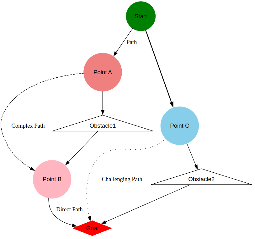
We evaluate our topology based navigation framework and compare it with prior methods in three scenarios (see Fig. 3). The environment is inherited from some of our previous works [15, 16, 17]
-
•
Scenario 1 (Goal Reaching): In this scenario, the robot is placed in an obstacle-free outdoor environment with an objective of reaching a given goal location.
-
•
Scenario 2 (Obstacle Avoidance): In this scenario, the robot is placed in an outdoor area with static obstacles such as trees, walls, and sharp hills. The goal is to reach the destination without colliding with obstacles.
-
•
Scenario 3 (Navigating on Uneven Terrains): In this scenario, the robot is placed in a highly elevated outdoor terrain where it might flip over or experience instability in some regions. The objective is to navigate to a goal location while avoiding steep elevations in the environment.
V-C Evaluation Metrics
TopoNav requires a comprehensive set of metrics to evaluate its performance. These metrics address TopoNav’s efficiency, agility, and adaptability in discovering and navigating through outdoor environments.
V-C1 Metrics for Efficient Exploration
-
•
Area Coverage (): This metric evaluates the extent of the environment explored by TopoNav. It is defined as:
(14) where is the newly explored area, and is the total size of the environment. Higher values indicate more efficient exploration.
-
•
Distance to Unexplored (): This metric reflects TopoNav’s inclination towards unexplored regions. It is calculated as:
(15) where is the distance from the robot to each point in the unexplored region . Smaller values signify a focus on exploring new areas
-
•
Information Gain (): TopoNav’s knowledge accumulation is quantified by this metric. It is estimated as:
(16) where is the entropy of the topological map . An increase in indicates enhanced understanding of the environment.
V-C2 Metrics for Adaptive Navigation
-
•
Success Rate (): This metric measures the robot’s ability to reach its goals:
(17) where is the number of successfully reached goals, and is the total number of goals attempted.
-
•
Path Efficiency (): TopoNav’s path optimality is evaluated using this metric:
(18) where is the length of the path taken, and is the shortest possible distance to the goal.
| Metric | Scenario 1 | Scenario 2 | Scenario 3 |
|---|---|---|---|
| Area Coverage (C_area) | |||
| Distance to Unexplored | |||
| (D_unexplored) | meters | meters | meters |
| Success Rate (R_success) | |||
| Path Efficiency (E_path) |
.
V-D Performance Analysis
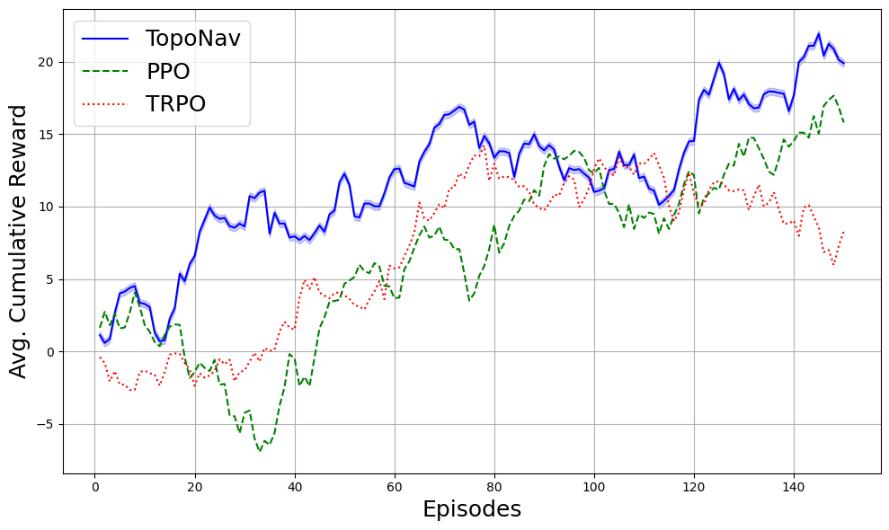
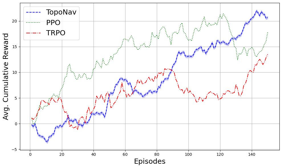
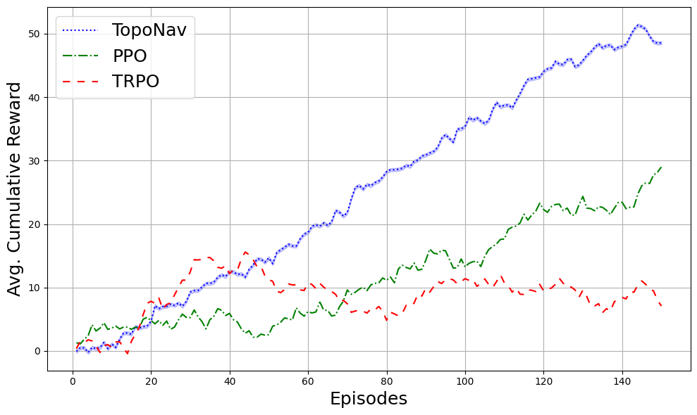
In Figure 3, we present a comparison of TopoNav against PPO and TRPO algorithms. The graph shows TopoNav’s reward trends for goal-reaching (a), obstacle avoidance (b), and uneven terrain navigation (c). TopoNav consistently performs well, learning steadily over time. It shows promise in obstacle-rich environments and excels on complex surfaces, surpassing TRPO and matching PPO’s performance levels. Moreover, Table I shows TopoNav’s outstanding performance from Scenario 1 to 3, with area coverage from to and success rate from to . These metrics reflect the system’s increasing challenges with environmental complexity. Moreover, path efficiency decreased to 70% in scenario 3, indicating room for optimization in navigating complex terrains. This evidence points to TopoNav’s strong potential for versatile and effective navigation tasks in varying conditions.
VI Conclusion, Limitations, and Future Directions
We present TopoNav framework for autonomous navigation, especially in sparse reward environments, through its integration of hierarchical reinforcement learning with dynamic topological mapping. However, challenges remain, particularly in its scalability to real-world scenarios and reliance on precise sensor data. In addition to improvements in sensor fusion techniques to enhance performance in a variety of conditions, we intend to test it extensively in the real world to further evaluate and improve its capabilities. Optimizing computational efficiency remains a key objective to broaden TopoNav’s applicability across various platforms. Addressing these areas will be crucial in enhancing TopoNav’s performance in real-world applications and promoting its widespread adoption in autonomous navigation.
References
- [1] Fatih Abut, Mehmet Fatih Akay, and Mohammad Abdeh. Autonomous navigation in search and rescue simulated environment using deep reinforcement learning. Balkan Journal of Electrical and Computer Engineering, 9(2), 2021.
- [2] Autonomous navigation of rovers for planetary exploration. IFAC Proceedings Volumes, 31(21):83–87, 1998. 14th IFAC Symposium on Automatic Control in Aerospace 1998, Seoul, Korea, 24-28 August 1998.
- [3] Nikolay Savinov, Alexey Dosovitskiy, and Vladlen Koltun. Semi-parametric topological memory for navigation. arXiv preprint arXiv:1803.00653, 2018.
- [4] Han Hu, Kaicheng Zhang, Aaron Hao Tan, Michael Ruan, Christopher Agia, and Goldie Nejat. A sim-to-real pipeline for deep reinforcement learning for autonomous robot navigation in cluttered rough terrain. IEEE Robotics and Automation Letters, 6(4):6569–6576, 2021.
- [5] Nuri Kim, Obin Kwon, Hwiyeon Yoo, Yunho Choi, Jeongho Park, and Songhwai Oh. Topological semantic graph memory for image-goal navigation. In Conference on Robot Learning, pages 393–402. PMLR, 2023.
- [6] Yugang Liu and Goldie Nejat. Multirobot cooperative learning for semiautonomous control in urban search and rescue applications. Journal of Field Robotics, 33(4):512–536, 2016.
- [7] Andrew Thoesen and Hamid Marvi. Planetary surface mobility and exploration: A review. Current Robotics Reports, 2(3):239–249, 2021.
- [8] Rana Azzam, Tarek Taha, Shoudong Huang, and Yahya Zweiri. A deep learning framework for robust semantic slam. In 2020 Advances in Science and Engineering Technology International Conferences. IEEE, 2020.
- [9] Dawei Sun, Mohammad Javad Khojasteh, Shubhanshu Shekhar, and Chuchu Fan. Uncertain-aware safe exploratory planning using gaussian process and neural control contraction metric. In Learning for Dynamics and Control, pages 728–741. PMLR, 2021.
- [10] Lei Tai and Ming Liu. Towards cognitive exploration through deep reinforcement learning for mobile robots. arXiv preprint arXiv:1610.01733, 2016.
- [11] Edward Beeching, Jilles Dibangoye, Olivier Simonin, and Christian Wolf. Learning to plan with uncertain topological maps. In European Conference on Computer Vision, pages 473–490. Springer, 2020.
- [12] Devendra Singh Chaplot, Ruslan Salakhutdinov, Abhinav Gupta, and Saurabh Gupta. Neural topological slam for visual navigation. In 2020 IEEE/CVF Conference on Computer Vision and Pattern Recognition (CVPR), pages 12872–12881, 2020.
- [13] Jose-Luis Blanco, Juan-Antonio Fernández-Madrigal, and Javier Gonzalez. A new approach for large-scale localization and mapping: Hybrid metric-topological slam. In Proceedings 2007 IEEE International Conference on Robotics and Automation, pages 2061–2067. IEEE, 2007.
- [14] Obin Kwon, Jeongho Park, and Songhwai Oh. Renderable neural radiance map for visual navigation. In Proceedings of the IEEE/CVF Conference on Computer Vision and Pattern Recognition, pages 9099–9108, 2023.
- [15] Jumman Hossain, Abu-Zaher Faridee, Nirmalya Roy, Anjan Basak, and Derrik E Asher. Covernav: Cover following navigation planning in unstructured outdoor environment with deep reinforcement learning. In 2023 IEEE International Conference on Autonomic Computing and Self-Organizing Systems (ACSOS), pages 127–132. IEEE, 2023.
- [16] Emon Dey, Jumman Hossain, Nirmalya Roy, and Carl Busart. Synchrosim: An integrated co-simulation middleware for heterogeneous multi-robot system. In 2022 18th International Conference on Distributed Computing in Sensor Systems (DCOSS), pages 334–341. IEEE, 2022.
- [17] Avi Spector, Wanying Zhu, Jumman Hossain, and Nirmalya Roy. Simulated forest environment and robot control framework for integration with cover detection algorithms. In 2022 IEEE/ACM International Conference on Big Data Computing, Applications and Technologies (BDCAT), pages 277–283. IEEE, 2022.