1-2 \Year2003 \Month02 \Pagespan000000 \lhead[0]A.N. Author: Title \rhead[Astron. Nachr./AN 324 (2003) 1/2]0 \headnoteAstron. Nachr./AN 324 (2003) 1/2, 000–000
ebisawa@obs.unige.ch
The ASCA Slew Survey
1 Introduction
We are systematically analyzing ASCA GIS data taken during the satellite attitude maneuver operation. Our motivation is to search for serendipitous hard X-ray sources and make the ASCA Slew Survey catalog.
Although ASCA is not designed to carry out observations during attitude maneuver/slew operation, the GIS instrument was operational and collecting X-ray events during most attitude maneuvers. GIS has a high time resolution ( 60 msec) so that it can determine the photon arrival direction while the satellite is moving (maximum maneuver velocity is 0.2 deg/sec). During its operational life from 1993 February to 2000 July, ASCA carried out more than 2,500 maneuver operations, and total exposure time during the maneuver was 415 ksec after proper GIS data screening.
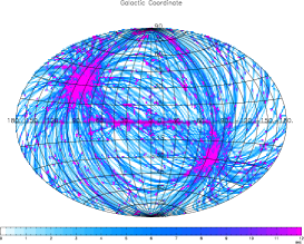
In total, 60 % of the sky (7.6 str) was scanned at least once, and the total exposure time area is 60 str sec. Therefore, average exposure time of the scanned region is 7.9 sec. See Figure 1 for the exposure map.
2 Preliminary Results
We found the most technically challenging part in this project is to determine the satellite attitude during the attitude maneuver accurately, since this is beyond the specification of the ASCA attitude control and determination system which is designed only for the pointing observations. We have been working with the engineers who have designed and built the ASCA attitude control and determination system.
Using the thus reconstructed satellite attitudes, we have processed all the maneuver data, and determined positions of GIS events. Average exposure time is 8 sec/FOV for a scanned region, during which we may collect 10 events for a 0.625 cts/GIS source using two GIS; this corresponds to 0.6 mCrab, and considered to be 3 sensitivity of our dataset.
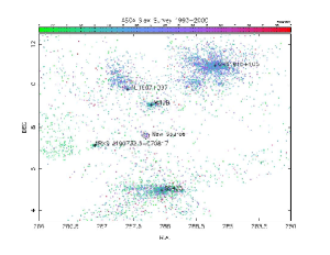
We expect to discover new hard X-ray sources which may be bright only above 2 keV and have not been detected by the ROSAT all sky survey. Actually, we did discover a new hard X-ray source at =(287.6, 7.7) in the north of SS433. Find the contrast in color (hardness) with the nearby ROSAT all sky survey source (1RXS J190732.6+070817).