A New Radio Continuum Survey of the Sky at 1465 MHz between declinations and
Abstract
We have mapped the total sky brightness at 1465 MHz in two adjacent declination bands with the portable 5.5-m parabolic reflector of the Galactic Emission Mapping (GEM) project, an on-going international collaboration to survey the radio continuum of the sky in decimeter and centimeter wavelengths. The observations were conducted from two locations, one in the USA and the other in Brazil, using a novel instrumental approach to overcome the well-known shortcomings of survey experiments. Our strategy consists of a 1-rpm rotating dish to circularly scan the sky at from zenith. The dish uses a rim-halo to re-direct the spillover sidelobes of its backfire helical feed toward the sky and the entire assembly has been enclosed inside a wire mesh ground shield in order to minimize and level out the contamination from the ground. The diffraction characteristics of this set-up have been succesfully modelled and undesired systematic striping across the observed bands has been carefully removed by a baseline propagation method which exploits the time-forward and time-backward intersections of the circular scans. The map displays nearly 300 hours of our best quality data taken with a HPBW of at a sensitivity of 20 mK.
INPE, CP 515 São José dos Campos, SP, 12201-970, Brazil
LBNL, MS 50-205, Berkeley, CA, 94720, USA
Centro Internacional de Física, Bogotá, Colombia
Dpto. di Fisica, Univ. di Milano, Via Bassini 15, 20133 Milano, Italy
1. Introduction
Today, as we witness the dawn of a precision era in observational cosmology, we are becoming increasingly aware that our present knowledge and understanding of the Galactic foregrounds demand a more thorough underpinning. During the course of this meeting we have learned about the results from the latest experiments for measuring the anisotropy in the Cosmic Microwave Background Radiation (CMBR). Yet, despite their success in ruling out a significant contamination of Galactic origin, there are still opened questions regarding the spatial and spectral distribution of the Galactic constituents. New insights have already improved on this picture as the work of Lazarian on Galactic dust properties and of Reynolds on Galactic free-free mapping through H association have been able to tell us. Such an effort also lies at the core of the Galactic Emission Mapping (GEM) project in order to reveal a new look of the Galactic synchrotron component, capable of overcoming the well-known shortcomings of the existing surveys; let alone the important implications for the search of spectral distortions in the CMBR.
2. The GEM Project at 1465 MHz
The GEM project (De Amici et al. 1994; Smoot 1999) was conceived 9 years ago at the XXIst IAU General Assembly in Buenos Aires, Argentina, when an international team of researchers set forth to develop a portable radiotelescope for achieving full-sky coverage between 408 MHz and 10 GHz. Since its first deployment in the Owens Valley desert near Bishop, CA, (USA) in 1994 the GEM experiment has operated from 3 other locations (Villa de Leyva in Colombia, Tenerife in the Canary Islands and Cachoeira Paulista in Brazil) and gathered observations at 4 of the 5 planned frequencies: 408 MHz (Torres et al. 1996), 1465 MHz (Tello 1997) and GHz (Torres, internal report, 1997). For the purpose of these proceedings I will restrict my attention to the data taken at the Owens Valley and Cachoeira Paulista sites at 1465 MHz which provide a nearly 75% sky-coverage.
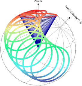
GEM’s mapping strategy uses a 1-rpm rotating dish to scan the sky around the zenith in wide circles, which due to the earth’s rotation provide complete sky coverage of an equally wide declination band (see Fig. 1). The GEM radiotelescope consists of a 5.5-m dish and is double-shielded against stray radiation from the ground. We use a rim-halo to intercept the spillover sidelobes and a wire mesh fence to further cut down and level out the contamination from the ground. By applying a geometric diffraction model to this experimental setup (Tello et al. 1999), together with measurements of the backfire helical feed pattern and selected field scan observations (Tello et al. 2000), we have nailed down the level of ground contamination, which so far has demonstrated to be one of the most significant sources of contamination in survey experiments. The collimated feed pattern has a HPBW of .
The radiometric signal is sampled at nearly half-second intervals by a thermally controlled total power receiver within a 90 MHz bandwidth. The system temperature is K and its gain is K. We have also performed a detailed study of the receiver systematics in order to predict its response to changes in the thermal bath of its components, such that the receiver baseline drifts at K/∘C and the relative gain change has a thermal susceptability of C.
3. Data Analysis and Results
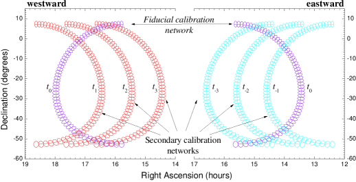
For some 20% of the data collected at 1465 MHz the stability of the receiver guarantees a 95% confidence level of spurious signal rejection due to gain variations on a timescale of 150-minute long observing runs. By keeping the Sun and the Moon at angles larger than and , respectively, from axis, a total of 8.5% of data had to be purged; while only 1.6% had to be excised due to RFI signals. In addition, the firings from a stable noise source diode at 44.8-s intervals were used to correct the received signals. Finally, we applied a de-striping algorithm (Tello 1997) to remove low frequency 1/f noise from the remaining observations. The technique relies on a sampling of the circular scans into networks of 120 half-a-beamwidth wide bins which, when divided into Eastern and Western sets, become fiducial baselines to calibrate the Western and Eastern scans that intercept them (see Fig.2). These calibrated scans can in turn be used to compose further bin networks to the East and West in order to propagate the map baseline across an entire declination band.
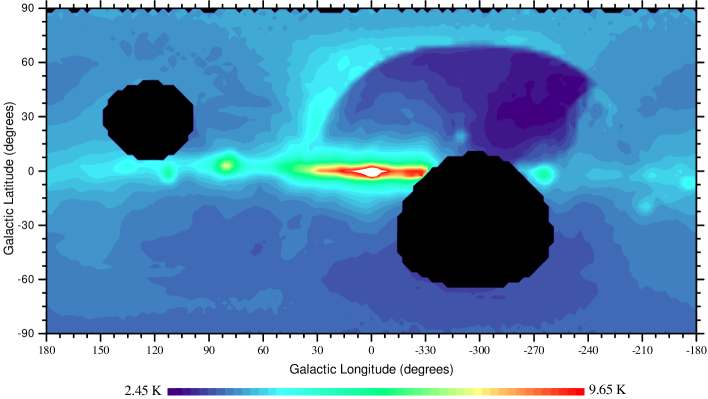
This technique presumes, however, the absence of stray radiation from the Galactic Plane. We have not yet compensated for this source of systematic effect in the data, which implies in a colder baseline than it should after it has propagated from a warm into a cold region of the sky, but the present status of our work can be best appreciated in the map of Fig. 3. This map combines 63.5 hours of data from the Bishop site with 212.65 hours from the Brazilian site and has been set to a pixel resolution of spanning an antenna temperature range from K to K in K steps.
Acknowledgments.
The GEM project, whose principal investigators appear as co-authors in the present contribution, has been the work of an outstanding team of researchers; mainly M. Bensadoun, M. Limon, G. De Amici, J. Gibson, J. Yamada, C. Witebsky, D. Heine, M. Leung, A. Alves, L. Arantes, C.A. Wuensche, N. Figueiredo, R. de Souza, A.P. da Silva and, last but not least, J. Aymon. This work was supported by FAPESP through grant No. 00/05436-1.
References
De Amici, G., Torres, S., Bensadoun, M., et al. 1994, Ap&SS, 214, 151
Smoot, G.F. 1999, in ASP Conf. Ser. Vol. 181, Microwave Foregrounds, ed. A. de Oliveira-Costa & M. Tegmark M. (San Francisco: ASP), 61
Tello, C. 1997, PhD Thesis, INPE-7036-TDI/664, SP, Brasil
Tello, C., Villela, T., Wuensche, C.A., et al. 1999, Rad. Sci. 34(3), 575
Tello, C., Villela, T., Smoot, G.F., et al. 2000, A&AS,
Torres, S., Cañon, V., Casas, R., et al. 1996, Ap&SS, 240, 225