*
Copyright
by
Author Name Required !!!
2024
The Dissertation Committee for Author Name Required !!!
certifies that this is the approved version of the following dissertation:
Title Required !!!
Committee:
Ashish Deshpande, Supervisor
Peter Stone, Co-supervisor
Joydeep Biswas
Garrett Warnell
Anca Dragan
Farshid Alambeigi
Junmin Wang
To my dearest parents, Karnan and Sumathy; my loving wife, Gayatri;
and my dear brother, Dinesh.
Acknowledgments
\@afterheading
I’m immensely grateful to several people who have helped me get where I am today. First, I begin by thanking my advisor, Peter Stone. Despite his several commitments, Peter has always found the time to advise me in my research journey. His immense interest in AI and Robotics and enthusiasm for exploring research ideas have helped propel my research journey to the fullest during my Ph.D., and I could not be more grateful and proud to have him as my advisor. I would also like to thank Garrett Warnell, who has been another pillar of great support throughout my PhD. My weekly interactions with Garrett and his thoughtful guidance on research have helped shape me into a better researcher. I would also like to thank all of my dissertation committee, Ashish Deshpande, Joydeep Biswas, Junmin Wang, Farshid Alambeigi, and Anca Dragan, for their support and being a part of my journey.
Reflecting on my journey, I vividly recall the day in the Fall of 2017 when I first came across Peter’s website, sending him an email wishing to be a part of the Learning Agents Research Group. Fast forward, I’m immensely proud to call myself a member of this group at UT Austin, and I’m grateful for all the personal and professional growth I’ve had during my time here. I’m grateful to Josiah Hanna and Siddharth Desai, my first collaborators at LARG who were warm and welcoming, introducing me to sim-to-real research, which was immensely rewarding to me. I would also like to thank my RoboCupHome team at UT, namely Rishi Shah, Justin Hart, Yuqian Jiang, Gilberto Briscoe-Martinez, and Dominick Mulder for an enriching RoboCup experience. I would like to thank everyone from the Learning Agents Research Group family, especially, Ishan Durugkar, Harel Yedidsion, Anirudh Nair, Reuth Mirsky, Xuesu Xiao, Yoonchang Sung, Chen Tang, Faraz Torabi, Sanmit Narvekar, Elad Liebman, Patrick MacAlpine, Piyush Khandelwal, Jinsoo Park, Eddy Hudson, Bo Liu, Yifeng Zhu, Jiaxun Cui, Michael Munje, Rolando Fernandez, Caroline Wang, Zizhao Wang, Zifan Xu, Jiaheng Hu, Siddhant Agarwal, Bharath Masetty, Brad Knox, Brahma Pavse, William Macke, Sai Kiran Narayanaswami, and Shahaf Shperberg. I would also like to thank all members of the Autonomous Mobile Robotics Laboratory, another family I’m immensely proud to be a part of and to have conducted research with, namely, Joydeep Biswas, Elvin Yang, Daniel Farkash, Rohan Chandra, Zichao Hu, Arthur Zhang, Sadegh Rabiee, Jarrett Holtz, Luisa Mao, Kavan Sikand, Corrie Van Sice, Amanda, Noah, Sadanand Modak, Rahul Menon, and Max Svetlik.
In particular, I would like to thank my amazing collaborators and friends at UT Austin: Siddharth Desai, Garrett Warnell, Josiah Hanna, Ishan Durugkar, Prasoon Goyal, Justin Hart, Elvin Yang, Daniel Farkash, Kavan Sikand, Eddy Hudson, Faraz Torabi, Yuqian Jiang, Luisa Mao, Zichao Hu, Rohan Chandra, and Xuesu Xiao. I would like to thank my former “RLHouse”mates Prasoon Goyal, Ishan Durugkar, and Sandhya for all the board game sessions and spicy Indian food we relished! I also wish to thank my incredible friends Sanjana Rajendran, Sravan Devanathan, Shilpa, Neha Dipali, Mukesh, Eddy, Anup, Madhuri, Chandana, Nithin, Mythreyi, Pritesh, Karthikeya, Manish, and Karishma for making my time in Austin worth cherishing.
I kickstarted my journey in robotics during my undergraduate days with the Robotics and Machine Intelligence club at NIT Trichy, and I would like to thank the club, and my dearest friends Akshay P Roy, Surya Teja Golkonda, Hariharan, Keshav Rai Goud, Prajval Kumar, Pranav Sundaram, Sripad, Adarsh Jagan Krishnamurthy, and Prakash Baskaran for being a part of that journey.
Finally, I would like to extend my deepest gratitude to my family. A special note of thanks goes to my partner and best friend, Gayatri, who has been an unshakeable foundation of strength, courage, and support in my life, uplifting my spirits through every challenge we have encountered together. I also thank her family, Sivaraman, Rajeswari, Harisree, and Ganesh for their encouragement and support. My heartfelt thanks to my parents, Karnan and Sumathy, my brother, Dinesh, my late grandfather Gopalakrishnan, and my grandmother Sakunthala, for their boundless love and support. Furthermore, I am immensely thankful to my closest friends Sravan, Sanjana, Mukesh, Keshav, Suraj, Pranav, Somya, Prajval, Ashwin, Hani, Surya, and Garan for their encouragement and love. Without their collective support, I could not have achieved this milestone.
Haresh Karnan
The University of Texas at Austin
May 2024
Abstract
Title Required !!!
Author Name Required !!!, PhD
The University of Texas at Austin, 2024
Supervisors: Ashish Deshpande, Peter Stone
Recent advances in the field of machine learning have led to new ways for mobile robots to acquire advanced navigational capabilities (Bojarski et al., 2016; Kahn et al., 2018; Kendall et al., 2019; Pan et al., 2018; Silver et al., 2010). However, these learning-based methods raise the possibility that learned navigation behaviors may not align with the intentions and preferences of people, also known as value misalignment. To mitigate this danger, this dissertation aims to answer the question “How can we use machine learning methods to align the navigational behaviors of autonomous mobile robots with human intentions and preferences?”
First, this dissertation answers this question by introducing a new approach to learning navigation behaviors by imitating human-provided demonstrations of the intended navigation task. This contribution allows mobile robots to acquire autonomous visual navigation capabilities through imitating human demonstrations using a novel objective function that encourages the agent to align with the navigation objective of the human and penalizes for misalignment. Second, this dissertation introduces two algorithms to enhance terrain-aware off-road navigation for mobile robots through learning visual terrain awareness in a self-supervised manner. This contribution enables mobile robots to obey a human operator’s preference for navigating over different terrains in urban outdoor environments and extrapolate these preferences to visually novel terrains by leveraging multi-modal representations. Finally, in the context of robot navigation in human-occupied environments, this dissertation introduces a dataset and an algorithm for robot navigation in a socially compliant manner in both indoor and outdoor environments. In summary, the contributions in this dissertation111A recording of the defense talk can be accessed here: https://youtu.be/MssiO6g0Gb8 take a significant step towards addressing the value alignment problem in autonomous navigation, enabling mobile robots to navigate autonomously with objectives that align with the intentions and preferences of humans.
Table of Contents
\@afterheading
\@starttoctoc
List of Tables
\@afterheading
\@starttoclot
List of Figures
\@afterheading
\@starttoclof
Chapter 1 Introduction
Advances in the field of machine learning and artificial intelligence for robotics have enabled mobile robots to become increasingly intelligent, efficient, and autonomous (Bojarski et al., 2016; Kahn et al., 2018; Kendall et al., 2019; Pan et al., 2018; Silver et al., 2010). Coupled with a leap in compute capabilities, especially of hardware accelerators enabling deep learning-based methods to learn from huge amounts of data (Hobbhahn and Besiroglu, 2022), autonomous mobile robots have gained improved capabilities such as real-time perception (Redmon et al., 2016; He et al., 2017; Radford et al., 2021b), planning (Chaplot et al., 2021; Tamar et al., 2016), and control (Bojarski et al., ; Pan et al., 2018; Karnan et al., 2022c; Xiao et al., 2020b, c; Kim et al., 2003). These advances in data-driven algorithms, combined with improved hardware and availability of large datasets (Perille et al., 2020; Karnan et al., 2022a; Biswas and Veloso, 2013) have contributed to increasingly intelligent and efficient autonomous mobile robotic agents (Ama, ; Khandelwal et al., 2017).
As these agents become more capable, there is a danger that their internal objectives may result in behaviors that do not align with the intentions and preferences of humans, also known as value misalignment.111Note that throughout this dissertation, we also refer to “alignment in behavior” which means the same as value alignment. A well-known story related to value misalignment dates to King Midas from Greek mythology, who wished that everything he touched would be turned into gold, but failed to anticipate that food and drink touched by him for consumption also would turn into gold, making it a regrettable wish that did not align with his intentions. Similarly, in robotics, value misalignment has been observed as a consequence of the effects of reward misdesign (Knox et al., 2022) and reward hacking (Hadfield-Menell et al., 2017); for example, a vacuum cleaning robot rewarded for collecting dust might begin to eject collected dust to accumulate more rewards (Russell, 2003). Several other instances of value misalignment in robotics have been observed in prior work (Amodei et al., 2016; Everitt, 2018; Ibarz et al., 2018; Lehman et al., 2020). Therefore, it is necessary to develop new methods that ensure that the behavior of autonomous driving agents aligns with the intentions and preferences of their human operators or owners.
This dissertation is especially concerned with the problem of autonomous robot navigation, i.e., to enable a robot to navigate autonomously, with minimal or no human supervision during deployment in ways that align with the intentions and preferences of people. Classical heuristic-based approaches (Dijkstra, 1959; Hart et al., 1968b; Xiao et al., 2020c) to this problem use hand-designed cost functions, planners, and kinodynamic controllers; and work well in structured environments such as industries and warehouses that are fully mapped, standardized for robot usage, and have minimal human presence. However, these approaches for navigation often struggle in unstructured, real-world conditions, including—but not limited to—navigation in unmapped novel environments, navigation on non-standard off-road terrains, and safe navigation in the presence of people.
To overcome the limitations of classical approaches to navigation, many in the research community have started using tools from machine learning. Unlike classical approaches that are heuristic-based and designed for specific environments (Xiao et al., 2020c), learning-based approaches offer the promise of learning patterns from data that may help the robot continually reason and adapt (Bojarski et al., ; Pan et al., 2018; Pomerleau, 1989; Tai et al., 2018; Xiao et al., 2020a). However, the success of learning-based approaches is dependent on designing the right objective function for navigation that reflects the human-intended task, since a poorly-defined objective function could lead to unintended (misaligned) behaviors (Amodei et al., 2016; Everitt, 2018; Ibarz et al., 2018; Lehman et al., 2020). For example, a mobile robot tasked with reaching a goal location outdoors in a collision-free route may choose to trample over a bed of flowers, which may be undesirable for its human operator. In an alternate scenario, when tasked with navigating in the presence of people while avoiding collisions, a mobile robot may choose to impolitely cut through groups of people, or move dangerously close to a human, behaviors that most humans would avoid. Conversely, at the other extreme, these robots may become overly cautious, leading to situations where they stop entirely and cease to make further progress, especially in complex or unpredictable environments. When mobile robots navigate in unexpected ways that are not generally preferred by humans, it may sometimes lead to catastrophic events, such as accidents with elderly people, visually impaired people, or children. Such public safety concerns in the past have led to autonomous mobile robots being banned from public roads and sidewalks (Gua, 2017; Sid, 2022).
To address the challenge of value alignment in autonomous navigation, the method of Learning from Demonstration (lfd)—as discussed by Argall et al. (2009) and Ravichandar et al. (2020)—emerges as a powerful approach. By inferring either the task objective or an imitating policy from such demonstrations, lfd enables the robot’s navigation behaviors to align with the intentions and preferences of the human operator. Alignment through lfd is predicated on the assumption that human demonstrations themselves contain such “aligned” behavior that reflects the intentions and preferences of the demonstrator. Given such a demonstration, one can infer the objective function of the intended task through inverse reinforcement learning (irl) (Ng and Russell, 2000; Ziebart et al., 2008), or recover the underlying navigation policy through behavior cloning (bc) (Bain and Sammut, 1999; Ross et al., 2010; Torabi et al., 2018a; Xiao et al., 2020a) or reinforcement learning (irl+rl) (Finn et al., 2016; Ho and Ermon, 2016).
Learning from Demonstrations (lfd) employs expert human task demonstrations to facilitate imitation learning of robot behaviors. However, alternative forms of human feedback also exist and have been instrumental in teaching robots to behave in ways that resonate with human intentions and preferences. For instance, Wang et al. (2021c) explored learning from evaluative feedback, a less demanding form of human input compared to task demonstrations. Other feedback types have also been explored in the literature, such as interventions (Wang et al., 2021a) and disengagements (Kahn et al., 2021b). In this dissertation, I explore Learning from Preferences (lfp), another paradigm utilizing preference rankings as the feedback mechanism, to achieve operator terrain preference-aligned navigation. In lfp, an operator reviews and ranks instances from the robot’s experience based on their preferences. Utilizing these preference rankings, lfp either learns an objective function followed by a policy (Brown et al., 2019; Bobu et al., 2020) or directly deduces a policy (Rafailov et al., 2023) that aligns with the operator’s specified preferences.
Building on these insights, the primary aim of this dissertation is to address the value alignment problem in robot navigation by leveraging human feedback through task demonstrations and preference queries to improve navigation in unstructured static and dynamic environments. Specifically, in static environments, this dissertation introduces algorithms that enable autonomous navigation in unmapped indoor and outdoor environments, while adhering to human intentions and preferences. For dynamic environments, a dataset and algorithms are introduced to enable a mobile robot to navigate in a socially compliant manner, while recognizing and reacting to the objectives of humans in the scene, also known as socially compliant navigation. Concisely, this dissertation will investigate the following question:
How can machine learning methods be applied to the task of autonomous navigation in unstructured environments such that the learned navigation behaviors of mobile robots align with the intentions and preferences of humans?
1.1 Contributions
This thesis answers the stated question through contributions on three key topics:
1. Visual Imitation Learning for Robot Navigation
Towards learning navigation policies on a mobile robot that align in behavior as demonstrated by a physically different agent such as a human operator, this dissertation introduces an imitation learning algorithm called Visual Observation-only Imitation Learning for Autonomous navigation (voila) (Karnan et al., 2021). voila introduces a novel reward function that overcomes a significant limitation of existing visual imitation learning algorithms—learning using video-only demonstrations from a physically different agent in the presence of egocentric viewpoint mismatch. voila was found to be successful at learning visual navigation policies end-to-end (mapping from raw sensor observations directly to low-level action commands) from human demonstrations in both simulated and physical robot experiments, that align in behavior with the human demonstrations. Chapter 3 discusses this contribution in detail.
2. Preference-Aligned Off-Road Navigation
Aligning a robot’s navigation behavior with an operator’s terrain preferences is a major challenge in visual off-road navigation. Prior approaches require extensive human labeling efforts, which are expensive and may not be scalable. To address this problem, this dissertation introduces two novel algorithms.
First, this thesis introduces Self-supervised TErrain Representation LearnING from unconstrained robot experience (sterling) (Karnan et al., 2023a), a self-supervised terrain representation learning algorithm that learns relevant terrain representations from easy-to-collect, unconstrained, and multimodal robot experience collected with any navigation policy. Following a two-step procedure, sterling learns relevant terrain representations in a self-supervised manner followed by operator preference querying, used to identify an operator’s preferences over traversed terrain examples. Given such preferences, a preference utility function can be learned, which can be used in real-time for preference-aligned off-road navigation on the robot. Through physical robot experiments in diverse outdoor environments, we find that sterling leads to navigation behaviors that are in alignment with an operator’s terrain preferences.
Second, this dissertation introduces an extension of sterling to extrapolate operator preferences for visually novel terrains. More often than not, a mobile robot might encounter novel terrains outside the training distribution for which the operator’s terrain preference is unknown, causing the robot to deal with uncertain situations. In certain cases, however, although a terrain looks visually novel, the proprioceptive feedback of the robot’s interaction with the terrain might feel similar to a previously traversed terrain. Leveraging this intuition, this dissertation introduces Preference extrApolation for Terrain awarE Robot Navigation (patern) (Karnan et al., 2023c) which extends the capabilities of sterling by extrapolating operator preferences from known to visually novel terrains. patern enhances the robot’s adaptability to unseen terrains, further aligning its navigation behaviors with human preferences. The methodology and effectiveness of patern are comprehensively discussed in Chapter 4, alongside sterling.
3. Socially Compliant Robot Navigation
While the above contributions advance the state of the art in aligning a robot’s navigation behavior with human intentions and preferences, the environments considered above are mostly static. However, an autonomous mobile robot deployed in urban environments might also need to deal with dynamic objects such as pedestrians, for which it is essential to act in a socially compliant manner to ensure politeness and safety. Towards addressing the social robot navigation problem through learning from demonstrations, this thesis introduces Socially CompliAnt Navigation Dataset (scand) (Karnan et al., 2022a), a large-scale dataset of demonstrations for socially compliant robot navigation. We show that learning a policy end-to-end through behavior cloning on scand leads to behaviors that are perceived by human participants as more socially compliant than a classical navigation stack (move_base). Additionally, this thesis introduces a novel hybrid algorithm (Raj et al., 2023) that utilizes both the classical navigation stack and an end-to-end learned policy, switching between the two using a learned policy classifier. Both the dataset and the novel hybrid algorithm are detailed in Chapter 5.
Figure 1.1 includes a flowchart summarizing the thesis question, problems, and their respective solutions proposed as contributions in individual chapters in this dissertation.

1.2 Reading Guide to the Thesis
The rest of the thesis is organized as follows. Note that the contributions in Chapters 3, 4, and 5 in this thesis are not necessarily written to be read in that order and readers can feel free to read specific chapters of interest.
-
•
Chapter 2 - Related Work. This chapter reviews prior work that is closely related to the dissertation question and the three contributions of this thesis.
-
•
Chapter 3 - Visual Imitation Learning for Robot Navigation. In this chapter, I introduce the voila algorithm for visual imitation learning from physically different expert’s video-only demonstrations for robot navigation. This chapter addresses Contribution 1 of this thesis.
-
•
Chapter 4 - Preference Learning for Off-Road Navigation. In this chapter, I introduce the sterling and patern algorithms for aligning off-road mobile robot navigation behaviors with operator preferences via self-supervised terrain representation learning and extrapolating operator preferences to novel terrains, respectively. This chapter addresses Contribution 2 of this thesis.
-
•
Chapter 5 - Socially Compliant Robot Navigation. In this chapter, I introduce the Socially CompliAnt Navigation Dataset (scand), a large-scale dataset of demonstrations for socially compliant robot navigation. I additionally introduce the hybrid algorithm for socially compliant robot navigation, leveraging classical and learned motion planners. This chapter addresses Contribution 3 of this thesis.
-
•
Chapter 6 - Conclusion and Future Work. In this chapter, I conclude by providing a recap of the three contributions of this thesis in addressing the central thesis question. I additionally describe some ongoing work that is derived from contributions of this thesis and present ideas for future work.
Chapter 2 Background
In this chapter, I provide an overview of the main areas of prior work related to this dissertation’s topic of aligning robot navigation behaviors with human intentions and preferences, while also highlighting the gaps in existing literature that this dissertation addresses. The related work sections in subsequent chapters will then delve into specific existing algorithms that are more closely related to each respective contribution. I begin this chapter in Section 2.1 with an overview of existing literature on imitation learning for robot navigation. Section 2.2 explores relevant studies in learning-based methods for off-road navigation, followed by Section 2.3 surveying related work on machine learning for social robot navigation. Section 2.4 extends the discussion to prior work on value alignment verification, particularly in the context of this dissertation’s contributions, and describes how it is brought to bear in each of the contributions. Note that, in this chapter, the scope is restricted to learning-based approaches to robot navigation. For a more in-depth survey of classical and learning-based approaches to robot navigation and to understand their limitations and trade-offs, readers are directed to the works of Xiao et al. (2020b), Tai and Liu (2016) and Tai et al. (2016).
2.1 Machine Learning for Robot Navigation
In this section, I explore prior approaches that utilize machine learning to enable autonomous navigation in mobile robots, specifically, imitation learning for robot navigation. I begin by exploring end-to-end approaches in machine learning for robot navigation, followed by reinforcement learning for robot navigation. Finally, I explore hybrid methods that combine machine learning with classical methods.
The use of machine-learning-based approaches to learn end-to-end autonomous navigation policies goes back several decades (Pomerleau, 1989; Lecun et al., 2005), though recent years have seen a spike in interest from the research community (Bi et al., 2018; Codevilla et al., 2017; Pan et al., 2018; Xiao et al., 2020b; Chang et al., 2020). One of the earliest successes was reported by Pomerleau et al. (Pomerleau, 1989), in which a system called alvinn used imitation learning to train a policy represented by an artificial neural network end-to-end (mapping from raw sensor observations directly to low-level control signals) to perform lane keeping based on demonstration data generated in simulation. Since then, several improvements, both in the amount and type of demonstration data and in network architecture and training, have been proposed in the literature. In particular, Lecun et al. (2005) proposed the use of a convolutional neural network (CNN) to better process real demonstration images for an off-road driving task. Bojarski et al. (2016) reported that gathering a large amount of real-world human driving demonstration data and applying data augmentation made it possible to train even more complex CNN architectures to perform lane keeping. Recently, Shah et al. (2023) and Sridhar et al. (2023) show that utilizing diverse open-source datasets from many robots to train a goal-conditioned navigation policy end-to-end serves as a good foundational control policy for goal-oriented navigation. Loquercio et al. (2018) proposed the DroNet architecture for learning to fly a UAV based on driving datasets collected on the road. Using supervised learning, DroNet was able to control a UAV autonomously in unstructured urban environments.
While the aforementioned approaches each use end-to-end imitation learning through supervised learning to find autonomous navigation policies, other machine learning for autonomous navigation work has adopted the alternative training paradigm of reinforcement learning. Chang et al. (2020) propose using off-policy Q-learning from video demonstration data to learn goal-conditioned hierarchical policies for semantic navigation. Liu et al. (2017) propose a context translation network to imitate an expert demonstration in the presence of viewpoint mismatch. While Liu et al. (2017) effectively address viewpoint mismatches, their method primarily handles third-person views and does not extend to the egocentric viewpoint mismatches central to the contribution in Chapter 3 of this dissertation. Similarly, Gaskett et al. (2000) propose a visual servoing algorithm that uses image template-matching to provide rewards for their reactive agent. The work by Pan et al. (2018) proposes using demonstrations from a privileged expert agent equipped with expensive sensors, to imitate the behavior on physically different hardware with cheaper sensors. The work closest to ours is that of Kendall et al. (2019), in which the proposed system learns a navigation policy using RL, where the reward function is the total distance traveled by their autonomous vehicle before a human driver intervenes (to, e.g., prevent collisions).
An alternative approach to end-to-end controller learning is using inverse reinforcement learning to recover a cost function for navigation, that can be used in conjunction with a classical planner to navigate. Wulfmeier et al. (2015, 2017) extend the Maximum Entropy Inverse Reinforcement Learning (meirl) (Ziebart et al., 2008) approach to deep cost function learning from lidar scans using a non-linear, neural network-based cost functions.
In the studies referenced above, while successful navigation behaviors are achieved through the methodologies employed, these outcomes are predicated on the assumption of similar physical forms between the imitator and the expert. This assumption of requiring similar physical forms between the expert and imitator agents becomes problematic particularly when the expert is a human and the imitator is a ground vehicle, leading to significant discrepancies in embodiment. Such disparities often result in viewpoint mismatches when using an egocentric camera as the primary sensor, rendering existing visual imitation learning algorithms ineffective. The discussion in Chapter 3 of this dissertation delves into this issue, introducing voila, a visual imitation learning algorithm that remains effective despite the viewpoint mismatches caused due to physical embodiment mismatch between the demonstrator and imitator agents.
2.2 Machine Learning for Off-Road Navigation
The problem of autonomous navigation in unstructured environments is well-studied, and several classical approaches have been proposed to address it (Pomerleau, 1989; Hart et al., 1968b; ROS-Planning, 2022; Biswas and Veloso, 2013; Khandelwal et al., 2017). While successful in long-term deployment scenarios, such classical heuristic-based approaches treat off-road navigation as geometric obstacle-avoidance (i.e., obstacles that are untraversable) problem. However, a mobile robot navigating in unstructured off-road environments may often experience a variety of terrains to traverse over with specific terrain traversability costs for navigation based on factors such as human preferences, ride comfort, or social norms. Classical approaches that solely perform geometric navigation will not be able to navigate in a terrain-aware manner, or worse, in some environments such as tall grass, a classical approach may choose not to navigate over it to avoid collisions, whereas, tall grass could be navigable for a mobile robot, and could be a human-preferred terrain to drive over. This lack of terrain-awareness of classical approaches to robot navigation has created a need for more advanced approaches to terrain-aware off-road navigation.
To overcome existing limitations of classical heuristic-based approaches to off-road navigation, recently, several learning-based approaches have been proposed that are promising for terrain-aware navigation in unstructured off-road environments. Kahn et al. (2021b) propose land for learning to navigate from disengagements. land takes a reinforcement learning-based approach where disengagements due to sub-optimal behavior of the agent are recorded to train the agent using reinforcement learning. Kahn et al. (2021a) propose badgr, in which available sensory redundancy on a mobile robot is leveraged to learn behaviors on different types of terrains. badgr learns a planner from off-policy trajectories collected onboard during exploration. This learned planner can safely ignore geometric obstacles (i.e., obstacles that are untraversable) and navigate through safe-to-travel regions avoiding regions that are lethal and bumpy. Yao et al. (2022) propose the rca algorithm for terrain-aware navigation to maximize ride comfort. In rca, an unsupervised representation learning algorithm is used to learn visual-inertial features from data collected on the robot.
The work most relevant to preference learning for navigation is vrl-pap by Sikand et al. (2022) in which a representation of visual patches of the terrain is learned and then the preference function is learned from the partial order rankings of terrains. While vrl-pap was shown to be successful at learning preference costs of terrains that align with the human operator’s interests, it requires structured concave demonstration trajectories such that the terrain of higher preference is the one being traversed and the lesser preferred terrain is present at the midpoint of the shortest path connecting the start and end location of the robot. This limitation of vrl-pap prohibits its applicability in situations where we have a large amount of unconstrained trajectory data, such as driving straight where the shortest path is indifferent structurally from the path traversed.
Each of the approaches above is limited in that it cannot learn from unconstrained robot trajectories for terrain-aware off-road navigation, aligning with human preferences. While vrl-pap (Sikand et al., 2022), the closest approach to this work can learn from geometrically constrained trajectory data, it requires data gathered on specific pairs of terrains encountered which may not be available in the environment. The sterling (Karnan et al., 2023a) algorithm introduced in Chapter 4 uses self-supervised non-contrastive representation learning from unconstrained robot experiences, enabling it to learn relevant terrain representations from robot trajectories of any geometric shapes and sizes, which can be utilized for operator preference-aligned off-road navigation. Additionally, Chapter 4 introduces patern (Karnan et al., 2023d) that enables extrapolating operator preference to visually novel terrains.
2.3 Machine Learning for Social Navigation
Recently, several algorithms have emerged that show the potential of applying learning to address challenges in robot navigation (Xiao et al., 2020b). Broadly speaking, in the robot navigation literature, learning-based approaches are successful in problems such as adaptive planner parameter learning (Xiao et al., 2020a), overcoming viewpoint invariance in demonstrations (Karnan et al., 2021), and end-to-end learning for autonomous driving (Bojarski et al., ; Pfeiffer et al., 2018; Wang et al., 2021b; Wurman et al., 2022).
Specifically in applying imitation learning for social navigation, the work by Tai et al. (2018) is the most relevant to this dissertation. They provide a simulation framework in Gazebo along with a dataset generated using the same where virtual human agents navigate following the social force model (Helbing and Molnár, 1995). They additionally train a social navigation policy using the Generative Adversarial Imitation Learning algorithm assuming the social force model as the expert demonstrator and show a successful deployment of the learned policy in the real-world on a turtlebot robot. While their work has shown that imitation learning can be applied to address the social navigation problem, they do so assuming the social force model in simulation as the expert, socially-compliant policy. Although simulated environments enable fast and safe data collection for online learning, they lack the naturally occurring social interactions seen in the wild.
Other learning paradigms such as rl have also been applied to address the social navigation problem. Everett et al. (2021) present ca-drl, a multi-agent collision avoidance algorithm learned using rl that shows impressive results in the real-world on specific social navigation scenarios. Kretzschmar et al. (2016) use inverse reinforcement learning on human demonstrations to learn cost functions for the socially compliant navigation task. Baghi and Dudek (2021) propose the sesno algorithm for sample efficient inverse reinforcement learning for social navigation using the UCY dataset (Lerner et al., 2007).
Both imitation learning and reinforcement-learning-based approaches discussed above have either used inaccurate simulators with simplified motion models or human-only pedestrian motion tracking datasets to learn socially compliant navigation behaviors. In this dissertation, I posit that a large-scale dataset of socially compliant navigation demonstrations involving a robot in human-occupied environments would help learn relevant socially compliant navigation policies for autonomous mobile robots. Towards addressing the problem of lack of large-scale datasets for social robot navigation, in Chapter 5, I present Socially CompliAnt Navigation Dataset (scand) (Karnan et al., 2022a), an extensive collection of robot social navigation demonstrations featuring multi-modal data captured in diverse real-world settings. This dataset, encompassing several hours of recordings from both indoor and outdoor environments, leverages two distinct robot morphologies and four different human demonstrators. To demonstrate the utility of this dataset, I employed an imitation learning algorithm to train an end-to-end policy. Experimental results affirm the feasibility of learning robot navigation policies, that are perceived by human participants as being more safe and socially compliant in comparison to a classical heuristic-based navigation policy. A notable insight from analyzing scand reveals that in approximately 80% of cases, a traditional heuristic-based planner aligns with a learning-based method. This observation prompts a reevaluation of learning-based strategies in social navigation. Consequently, I propose a new hybrid approach for social robot navigation, detailed in Chapter 5.
2.4 Value Alignment Verification
The preceding sections of this chapter have reviewed various learning-based algorithms documented in the literature that help learn robot navigation behaviors, that align with human intentions and preferences. This section extends the discourse to survey related work on the topic of value alignment verification—specifically, verifying whether the learned navigation policy aligns with the human operator’s intentions and preferences. Note that the core contributions of this dissertation are centered around devising algorithms and datasets that enable mobile robots to navigate in accordance with a human operator’s intentions and preferences, and not to propose new ways to verify value alignment. This is still an active area of research in the field of machine learning and falls beyond the scope of this dissertation.
Brown et al. (2021) formally introduce the value alignment verification problem and propose designing a driver’s test to efficiently verify whether an AI system is aligned with a human’s values through a minimal number of queries. Exact value alignment involves sampling the policy at all possible states which can be expensive and are often impossible to evaluate since the number of states can be prohibitively large for some tasks, such as autonomous driving. To tackle this, Brown et al. (2021) propose heuristic and approximate value alignment verification for grid-world and continuous action domains. Hadfield-Menell et al. (2016) propose cirl which introduces a cooperative game between the agent and the human, where both agents are rewarded according to the human’s reward function, but unlike the human, the robot does not initially know the reward function. While cirl ensures the robot’s learned policy asymptotically converges to the human intended values, it does not propose a way to verify this alignment. Evaluating social compliance in robot navigation is still an unsolved problem in the navigation community. For further details, Francis et al. (2023) recently published a comprehensive survey on principles and guidelines for evaluating social robot navigation. There have been several proposed approaches both using simulation (Tsoi et al., 2020, 2021; Kästner et al., 2023) and physical robot experiments (Svensson, 2003; Pirk et al., 2022). The inaccuracy of long-term human motion models, the wide variety of social navigation scenarios, and the subjectivity of “socialness” in navigation make evaluating social compliance a challenging task in robot navigation. Knox et al. (2022) highlight major flaws in existing human-designed reward functions for autonomous driving, and propose eight sanity checks for a human-designed reward function, underscoring the importance of addressing the value alignment problem in robot navigation by alleviating reward misdesign.
In this dissertation, we take different approaches in each contribution to verify the alignment of the learned navigation behavior to a human operator’s intentions and preferences. To verify the alignment of the policy learned using voila, we report the Hausdorff distance of the imitated trajectory to the ground truth trajectory demonstrated by the human. We verify that the learned policy imitates the intended navigation behavior by checking that the trajectory traced by the learned policy closely matches the human-demonstrated trajectory in the physical robot experiments. Additionally, in simulation experiments, in novel environments unseen by the agent, we report the Hausdorff distance of the robot’s states between the human-demonstrated trajectory and the trajectory traced by the learned policy and find that the imitated policy closely follows the unseen human demonstrated trajectory, verifying that voila has indeed learned the intended navigation behavior. In Chapter 4, to validate the preference alignment of the trajectories traced by sterling and patern algorithms, we utilize a success metric in which a trajectory traced by the robot using any algorithm from start to goal locations are considered successful if it adheres to the operator’s ranked preferences over the terrains. In Chapter 5, to verify alignment with human preferences for socially compliant navigation, we perform a human participant study with post-experience questionnaires requesting feedback on a Likert-scale, evaluating social compliance, and safety of the learned controller.
Chapter 3 Visual Imitation Learning for Robot Navigation
In this chapter, I introduce the first contribution of this thesis, Visual-Observation-only Imitation Learning for Autonomous navigation (voila) (Karnan et al., 2021), a visual imitation learning algorithm for autonomous navigation in the presence of egocentric viewpoint mismatch between a physically different demonstrator such as a human, and a mobile robot as the imitator. This chapter is organized as follows. The introduction, Section 3.1, provides an overview of this contribution, followed by background and related work in Section 3.2. Section 3.3 introduces voila and the novel reward function for visual imitation learning. Sections 3.4 and 3.5 provide details on the implementation and the experiments performed for evaluation, respectively.
3.1 Introduction
Enabling vision-based autonomous robot navigation has recently been a topic of great interest in the robotics and machine learning community (Bojarski et al., ; Codevilla et al., 2017; Pan et al., 2018). As discussed in Section 2.1, imitation learning in particular has emerged as a useful paradigm for designing vision-based navigation controllers. Using this paradigm, the desired navigation behavior is first demonstrated by another agent (usually a human), and then a recording of that behavior is supplied as training data to a machine learner that tries to find a control policy that can mimic the demonstration. To date, most approaches in the navigation domain that use imitation learning require demonstration recordings that contain both state observations (e.g., images) and actions (e.g., steering wheel angle or acceleration) gathered onboard the deployment platform (Bojarski et al., ; Codevilla et al., 2017; Lecun et al., 2005; Tampuu et al., ).
As explored in Section 2.1, while these existing imitation learning approaches have proved successful in certain scenarios, there are situations in which it would be beneficial to relax the requirements they impose on the demonstration data. For example, if we wish to collect a large number of demonstrations from many experts, it may prove too difficult or costly to arrange for each expert to operate specific deployment platforms, which are often expensive or difficult to transport. Additionally, it might be costly to outfit all demonstration platforms with instrumentation to record the control signals with the demonstration data. However, due to the low cost and portability of video cameras, it may still be feasible to have demonstrators record ego-centric video demonstrations of their navigation behaviors while operating a different platform. Demonstrations of this nature would consist of video observations only (i.e., they would not contain control signals), and, because of the difference in platform, the videos would likely exhibit ego-centric viewpoint mismatch compared to those that would be captured by the deployment platform. One example of such data is the plethora of vehicle dashcam videos available in publicly accessible databases (Chan, 2017) or on YouTube. Another example is video demonstrations of robot behaviors generated by proprietary code that one would like to mimic on the same or different robot hardware. Unfortunately, to the best of our knowledge, there exist no current imitation learning techniques for vision-based navigation that can leverage such demonstration data.
Fortunately, recent work in Imitation from Observation (ifo) (Torabi et al., 2019)—imitation learning in the absence of demonstrator actions—has shown a great deal of success for several related tasks. For example, work in this area has been able to learn from video-only demonstrations for both simulated and real limbed robots (Pavse et al., 2019; Torabi et al., 2018c; Sermanet et al., ; Pan et al., 2019). However, no literature of which we are aware has considered whether these ifo techniques can be applied to the vision-based autonomous navigation problem outlined above. This problem is especially challenging since physical differences in the demonstration platform introduce viewpoint mismatch in the video demonstrations.
In this Chapter, I present our hypothesis that it is possible to learn visual robot navigation policies that are aligned with a demonstrator’s intentions, even if such demonstrations contain significant viewpoint differences due to embodiment mismatch between the demonstrator and the robot. To this end, we introduce a new ifo technique for vision-based autonomous navigation called Visual-Observation-only Imitation Learning for Autonomous navigation (voila).111A preliminary version of this work was presented at the 2021 AAAI Spring Symposium on Machine Learning for Navigation. The final version was published at the 2022 ICRA conference. To overcome viewpoint mismatch, voila uses a novel reward function that relies on off-the-shelf keypoint detection algorithms that are themselves designed to be robust to egocentric viewpoint mismatch. This novel reward function is utilized to drive a reinforcement learning procedure that results in navigation policies that imitate the demonstrator.
We experimentally confirm our hypothesis both in simulation and on a physical Clearpath Jackal robot.222The research described in this chapter was done in collaboration with Garrett Warnell, Xuesu Xiao, and Peter Stone. We compare voila against a state-of-the-art ifo algorithm gaifo (Torabi et al., 2018c), and show that voila can learn to imitate an expert’s visual demonstration in the presence of viewpoint mismatch while also generalizing to environments not seen during training. Additionally, we demonstrate the flexibility of voila by showing that it can also support vision-based training of navigation policies with observation inputs other than camera images.
3.2 Background and Related Work
The proposed approach, voila, performs reinforcement learning (RL) using a novel reward function based on image keypoints in order to accomplish imitation from observation for autonomous navigation with viewpoint mismatch. In this section, I review related work that is more closely related to voila, such as autonomous robot navigation, imitation from observation, and computer vision techniques for visual feature extraction. For a more general literature review on machine learning for robot navigation, refer to Section 2.1.
3.2.1 Machine Learning for Autonomous Navigation
The use of machine learning methods in the design of autonomous navigation systems goes back several decades, though recent years have seen a spike in interest from the research community (Bi et al., 2018; Codevilla et al., 2017; Pan et al., 2018; Xiao et al., 2020b; Chang et al., 2020). One of the earliest successes was reported by Pomerleau (1989), in which a system called alvinn used imitation learning to train an artificial neural network that could perform lane-keeping based on demonstration data generated in simulation. Since then, several improvements, both in the amount and type of demonstration data and in network architecture and training, have been proposed in the literature. In particular, Lecun et al. (2005) proposed the use of a convolutional neural network (CNN) to better process real demonstration images for an off-road driving task, and, more recently, Bojarski et al. reported that gathering a large amount of real-world human driving demonstration data and applying data augmentation made it possible to train even more-complex CNN architectures to perform lane keeping.
The work closest to ours is that of Kendall et al. (2019), in which the proposed system learns a navigation policy using RL, where the reward function is the total distance travelled by their autonomous vehicle before a human driver intervenes (to, e.g., prevent collisions). However, unlike voila, Kendall et al. (2019) utilize experience gathered exclusively by the learning platform itself, considering neither imitation from observation nor the particular problem of viewpoint mismatch.
3.2.2 Imitation from Observation
Recently, there have been a number of imitation from observation (ifo) techniques introduced in the literature, including an adversarial approach called gaifo (Torabi et al., 2018c; Karnan et al., 2022d) that we use here as a baseline. In gaifo, the reward signal is provided by a learned discriminator network that seeks to reward state transitions similar to those present in the demonstration and penalize—if it can tell the difference—state transitions that come from the imitator. While gaifo (Torabi et al., 2018c) has been shown to be successful in both low- and high-dimensional observation spaces, it has thus far only been applied to continuous control tasks for limbed agents. Moreover, as we will show in our experiments in Section 3.5, while gaifo can imitate the expert when the egocentric viewpoints between the expert and the imitator match, it is unable to do so in the presence of viewpoint mismatch.
Viewpoint mismatch in ifo has been previously considered in the work by Sermanet et al. , which proposes Time Contrastive Networks (tcns). tcns use a triplet loss metric to learn a feature space embedding which is then used for rewarding the agent to imitate the expert. While both voila and tcns are robust to viewpoint mismatch, tcns require demonstration data with multiple viewpoints in the same timestep to learn an embedding space robust to viewpoint mismatch, whereas voila achieves this robustness by leveraging feature detection algorithms (e.g sift by Lowe (1999)) commonly used in slam that are themselves designed to be robust to viewpoint mismatch.
3.2.3 Feature Detection and Matching
To overcome viewpoint mismatch, voila utilizes a novel reward function that relies on local image features such as keypoints and their descriptors. Keypoints have been used for decades to solve challenging tasks such as image verification, matching, and retrieval. More recently, deep-learning-based keypoint extractors such as superpoint by DeTone et al. (2018) have been shown to be more successful than classical approaches. In this work, we use superpoint to detect keypoints and their corresponding descriptors, and we determine keypoint matches between two images using the typical method based on the two nearest neighbors in descriptor space (DeTone et al., 2018) using the distance metric. However, in principle voila can be used with any local feature detector or feature-matching algorithm. In our experiments, we use the simplest image retrieval algorithm of local keypoint detection followed by nearest neighbor matching in the descriptor space to identify the visually closest image with maximum keypoint matches. However, there exist more sophisticated algorithms such as netvlad (Arandjelović et al., 2016; Sarlin et al., 2018) that are more robust to visual aliasing errors for the task of image retrieval which can be used with voila with no changes to the underlying algorithm.
3.2.4 SLAM-based Approaches for Navigation
Visual Teach and Repeat (vtr) methods such as the one proposed by Furgale and Barfoot (2010) follow a two-step approach to imitating a navigation demonstration. First, a SLAM map of the demonstration environment is built in the teach phase. In the subsequent repeat phase, the robot localizes within a submap of the environment and follows a desired trajectory. voila, on the other hand, learns a reactive navigation policy directly from demonstrations, sidestepping the SLAM problem.
3.3 Visual Imitation Learning for Autonomous Navigation
In this section, I formulate the visual imitation learning problem for the task of autonomous visual navigation, which we pose as a reinforcement learning problem with a demonstration-dependent reward. The critical contribution of voila is the development of this particular reward function, as described in detail below.
3.3.1 Preliminaries
We treat autonomous visual navigation as a RL problem where the environment is a Markov decision process. At every time step , the state of the agent is described by , the observation of the agent is described by , and an action is sampled from the agent’s policy .333While voila’s reward function depends on camera images, the imitation policy can actually be learned over any appropriate state representation—vision-based or otherwise. We show one such example using LiDAR scans as the state representation in Figure 3.4. A single expert demonstration is represented as a set of sequential observations . Performing this action in the environment leads to a next state , where is the unknown transition dynamics of the agent in the environment. For this specific transition, the agent receives a reward, , which is a function of both the agent’s transition tuple and the demonstration, i.e., . The relative utility of near-term and long-term reward is controlled using the discount factor . The RL objective is to find a policy that maximizes the expected sum of discounted rewards .
3.3.2 Reward Formulation for Imitation Learning
For each transition experienced by the learner, we require a reward such that the learner, by optimizing the RL objective with this reward, can learn to imitate the demonstration. In particular, because we wish to perform learning in real-time, we seek a dense reward function that provides feedback at each timestep without delay. Since the expert demonstrations are from a physically different agent, there can be significant ego-centric viewpoint mismatch between the observation spaces of the learner and the demonstrator as shown in Figure 3.4. Such a mismatch poses a challenge to designing a good reward function since it is not immediately clear how to compare images from different viewpoints. Hence, we introduce here a novel reward function based on keypoint feature matches between the expert and the imitator’s ego-centric observations for the task of imitation learning for visual navigation. Keypoint detectors have been extensively used in the computer vision community for several decades to solve challenging tasks like structure-from-motion (sfm), visual slam and hierarchical localization. Recent keypoint detection algorithms such as superpoint by DeTone et al. (2018) provide invariance to perspective distortion, scaling, translation, rotation, viewpoint mismatches, and varied lighting conditions between the key and query images. Hence, we use keypoint detectors to help define the reward function to learn visual navigation policies from demonstrations provided by any other agent.
The reward function we propose relies on a quantity that we call match density. We define the match density between two images and as the ratio of the number of keypoint matches between and , and the total number of detected keypoints in . , assuming there is always a non-zero number of keypoints detected in an image. Additionally, instead of imposing a temporal alignment constraint, we define the reward for a particular transition by searching the demonstration for the image which is most visually similar to the learner’s current observation. Here, we define the most visually similar image in the expert demonstration to be the one that has the highest match density with , which we denote as . Figure 3.4 shows the imitator’s current observation and corresponding visually closest expert image . For convenience of notation, we denote the next image after in the demonstration sequence as .
Using the concepts described above, we now define the proposed reward function for voila:
| (3.1) |
where and . If the robot is in the done state, i.e., it has crashed (as detected in AirSim, or by the trainer in physical experiments) or the number of keypoint matches drop below 10, the agent receives a penalty reward of . Otherwise, the agent is in the state, and we assign a reward that depends on terms and . The term assigns reward value based on the match density encountered at the next observation that the agent ends up in the transition. This component encourages the agent to stay on the demonstrated trajectory. The term is similar to a potential-based shaping term, and rewards a transition based on the difference in the match densities with the next expert observation and the imitator’s observations. This component encourages the imitator to find a policy that exhibits similar state transitions to those experienced by the expert. We additionally found that adding the action penalty term with a of penalizes the agent for making large steering changes. Since the maximum value of the reward function in the alive state is 2, we heuristically picked a value 5 times higher and arrived at -10 for the negative penalty. This value worked well empirically in our experiments; we do not have any reason to believe that the results are particularly sensitive to this exact value. The expert image retrieval step is performed in real-time using feature matching and is outlined in the implementation section.
3.4 Implementation
In this section, I provide specific implementation details of voila including those related to representation learning, keypoint feature extraction, and the network architectures.
3.4.1 Representation Learning
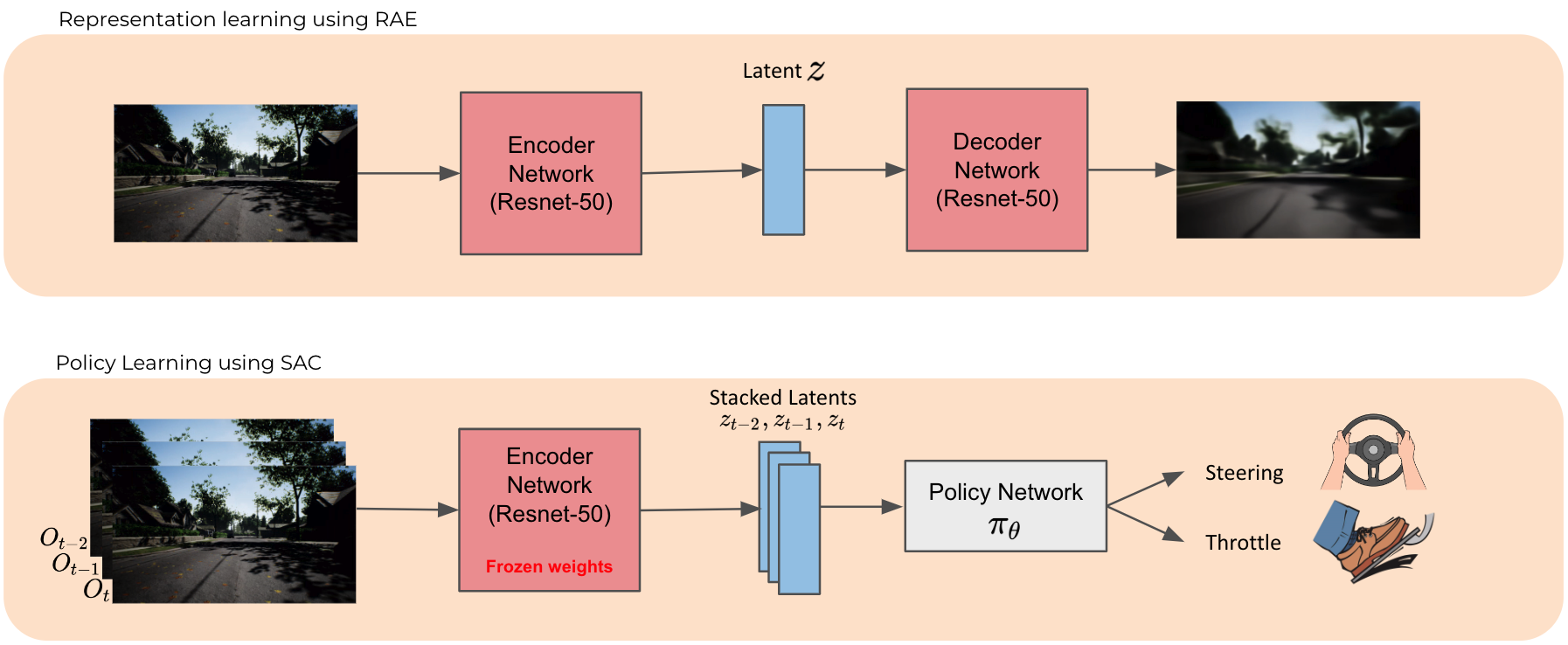
Representation learning using unsupervised learning is a powerful tool to improve the sample efficiency of deep RL algorithms. Instead of learning a navigation policy over high dimensional image space, voila uses a latent representation of the image and learns the navigation policy over this latent code as input to the policy. Specifically, voila uses a Regularized Auto Encoder (rae) (Ghosh et al., 2020) to learn a latent posterior of the visual observations of the imitator. The imitating control policy is then learned using RL with the latent code as the input to the policy network, where is the encoder of the rae with weights . A ResNet-18 encoder-decoder network architecture is used for the rae and is trained for the task of image reconstruction, with data collected from the imitator using random rollouts. The input images are of size and the size of the latent dimension is . Random cropping and random affine image augmentations are utilized to regularize training.
3.4.2 Keypoint Feature Extraction
As a preprocessing step, all superpoint features detected from expert observations are stored in a buffer. At the start of an episode (for the first frame), the nearest expert observation to is retrieved by linearly searching for the closest expert observation in with the maximum feature matches. As the episode unfolds, instead of exhaustively searching for the closest expert image at every transition, the search is restricted over the three next expert observations forward in time from the previous closest expert image in . At each transition, superpoint keypoints and descriptors are extracted and used to retrieve the closest expert image and compute the reward according to Equation 3.1. Note that the superpoint keypoint descriptors extracted in an image are the local features and not the global features for that image. Hence, we explicitly train an rae to learn a compressed global representation of the image for training the navigation policy, as described in the previous section. The superpoint descriptor for every keypoint is a vector of 512 float values. These descriptors are learned from data and correspond to different features of a keypoint including—but not limited to—lighting, location, appearance, and texture.
3.4.3 Navigation Policy Architecture
As shown in Figure 3.1, we model the navigation policy using a 3-layer, fully-connected neural network, with 256 neurons per layer. We frame-stack three consecutive latent codes of observations in time to alleviate the effects of partial observability in the environment. We also additionally include the most recent action performed by the agent as a part of the state. We use Soft Actor-Critic (sac) by Haarnoja et al. (2018), an off-policy RL algorithm, to learn .
3.5 Experiments
I now describe the experiments that we performed to evaluate voila. The experiments are designed to answer the following questions:
-
()
Is voila capable of learning imitative policies from video demonstrations that exhibit viewpoint mismatch?
-
()
How well do policies learned using voila generalize to environments unseen during training?
-
()
Does voila work with sensor modalities other than vision?
To answer the questions above, we performed experiments using both a simulated autonomous vehicle and a real Clearpath Jackal robot on the task of imitating “road following” and “hallway patrol” tasks, respectively. The objective of the voila agent is to imitate the expert’s visual demonstration by learning an end-to-end navigation policy, even in the presence of viewpoint mismatch. To quantify the performance of imitation policies, we compute the Hausdorff distance metric (lower is better) between trajectories generated on a held-out set of environments.
3.5.1 Simulation Experiments in AirSim
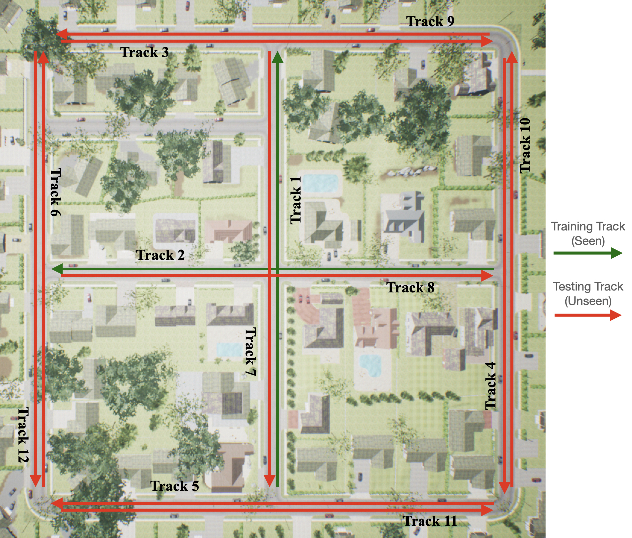
In our simulation experiments, we answer questions and using the outdoor ‘Neighborhood’ environment in AirSim (Shah et al., 2017) and learn the task of road following, i.e., driving on a straight road avoiding collisions with obstacles such as parked cars along the curb while dealing with varied lighting conditions along its path. To this end, we pick 12 straight road segments (tracks) in the AirSim environment, as shown in Figure 3.2. Two tracks (Track 1 and 2) were used for training the agent, and the learned policy was deployed on all 12 tracks. The other 10 tracks and their expert demonstrations were not seen by the agent before evaluation, and so we use them to test the generalizability of the learned policy to unseen environments. In each episode, the car begins at a randomized initial position near the start of the track, so the agent cannot trivially solve the task by learning to drive straight without having to steer. The expert demonstrations consist of a single trajectory (egocentric, front-facing images) for all tracks provided by a human (the first author) controlling the demonstration vehicle with the objective of navigating from start to end of the tracks, driving straight, in the middle of the road, and avoiding collisions with obstacles such as parked cars.
We use the latent vector of the rae as the state representation, and the action space consists of changes in steering and throttle values. Note that expert demonstrations were required only during training to compute the reward. At test time, the agent imitates the expert without requiring access to expert demonstrations.
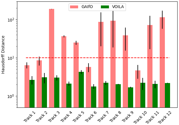
We compare voila against gaifo (Torabi et al., 2018b, c), a state-of-the-art ifo algorithm that does not explicitly seek to overcome viewpoint mismatch. While both gaifo and voila are ifo algorithms that can imitate from video-only demonstration data, gaifo has been evaluated predominantly in domains such as limbed-robot locomotion and manipulation, whereas voila has been designed specifically for vehicle navigation domains. Additionally, gaifo uses a learned reward function whereas in voila, we propose a manually defined, demonstration-dependent reward function that is not learned. To ensure a fair comparison, we provide each algorithm the same state representation, i.e., the latent code of the rae. Further, since gaifo is an on-policy algorithm whereas voila relies on the off-policy sac algorithm, we allow gaifo ten times more training timesteps than voila (1 million vs. 100,000). Finally, we report results for gaifo using the policy that achieved maximum on-policy returns during training.
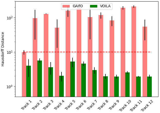
Figure 3.3(a) compares voila and gaifo without any viewpoint mismatch between the expert and imitator; we see that gaifo, as expected, is able to imitate the expert demonstration on the training Tracks 1 and 2, but it fails to generalize to most unseen tracks. The policy trained with voila performs better than gaifo at imitating the expert demonstration on the training tracks, and also generalizes to unseen environments, addressing . Figure 3.3(b) addresses both and . In Figure 3.3(b), in the presence of viewpoint mismatch, we see that, as expected, gaifo is unable to imitate the expert on the training Track 2 and does not generalize to other environments. However, confirming our hypothesis, voila is able to imitate the expert demonstration even in the presence of viewpoint mismatch on seen Tracks 1 and 2 and also generalizes to the other 10 unseen tracks.
In summary, in the simulation experiments performed on AirSim, we observed that voila is indeed capable of learning imitative policies from video-only demonstrations even in the presence of significant viewpoint mismatch (addressing ), and a policy learned using voila does generalize to novel environments (addressing ).
3.5.2 Physical Experiments on the Jackal
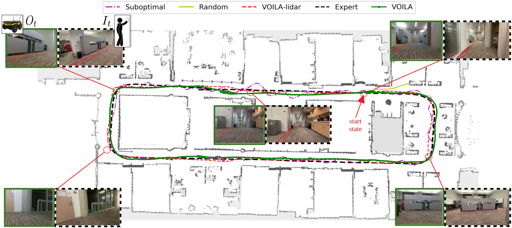
To answer and on a physical robot, we performed experiments using a Clearpath Jackal—a four-wheeled, differential drive ground robot equipped with a front-facing camera. The environment considered is an indoor office space, shown in Figure 3.4, consisting of carpeted floors, straight hallways, intersections, and turns. There are also static obstacles such as benches, chairs, whiteboards, pillars along the wall, and trashcans, all of which the robot needs to avoid colliding with.
We evaluated voila on a hallway patrol task, in which the robot begins at a start state (shown in Figure 3.4) and patrols around the building clockwise by taking the first right at intersections and driving straight in the hallways. To obtain a video demonstration of this task from a physically different agent, a human (the first author) walked the patrol trajectory once while recording video using a mobile phone camera held approximately 4 feet above the ground (the robot’s camera is at approximately 0.8 feet from the ground). To contrast the imitation learning performance of voila with and without any viewpoint mismatch, we performed additional experiments, henceforth called voila-w/o-mismatch in which the expert demonstrations were collected onboard the deployment platform itself. These demonstrations were collected using the ros move_base (ROS-Planning, 2022) navigation stack with a pre-built map of the environment and waypoints to patrol the environment while recording the egocentric visual observations from the front-facing camera.
A voila training episode consists of the robot starting at approximately the same start state (as shown in Figure 3.4) and exploring in the training environment until the agent reaches the done state. After each training episode, the robot was manually reset back to the start state by a human operator, and a new training episode began. Training the navigation policy happened onboard the robot on a gtx 1050Ti gpu.
The voila agent trained using demonstrations with and without viewpoint mismatch learned to imitate the expert within 90 minutes (120 episodes) and 60 minutes (100 episodes), respectively, of experiment time (including time taken to reset the robot at the end of an episode). Figure 3.4 shows the trajectory rollout (in green) of the policy learned using voila, imitating the expert demonstration in the presence of viewpoint mismatch. Addressing , we see that voila is able to successfully patrol the indoor environment in a real-world setting, as demonstrated by a physically different expert agent, in the presence of viewpoint mismatch.
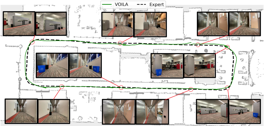
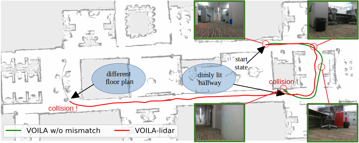
To evaluate the generalizability of policies learned using voila to unseen real-world conditions (), first, we deploy the policy learned by voila in a ‘perturbed environment’, in which positions of movable objects such as trashcans, doors, whiteboards, chairs, and benches in the training environment are perturbed as shown in Figure 3.5. We see that, with such environmental changes, voila is able to successfully patrol the hallway without any collisions. Second, we deploy voila on a different floor within the same building, with major visual and structural differences from the training environment as shown in Figure 3.6. While the robot succeeds for much of the trajectory, this experiment demonstrates the limitations of the current approach, as the robot collides with the walls in two places where there are large visual differences from the training environment.
To quantify the imitation learning performance of voila, we compute the Hausdorff distance between the human demonstrated trajectory and the trajectory generated by the policy learned using voila, provided in Table 3.1. The Hausdorff distance between the human demonstration and voila is 0.783, whereas the voila-w/o-mismatch agent trained using demonstrations without any egocentric viewpoint mismatch achieves a Hausdorff distance of 0.665. To provide context for the Hausdorff distance metric, we also compute the Hausdorff distance for suboptimal and random trajectories. The suboptimal trajectory was collected by navigating along the hallway in a zig-zag route using move_base by setting waypoints closer to the walls and achieves a Hausdorff distance of 0.806. The random trajectory was collected using a randomly initialized policy, which fails quickly by crashing in the environment, achieving a Hausdorff distance of 1.192. We see that the voila agent is able to successfully imitate the expert’s video-only navigation demonstration and patrol the hallway without any collisions, addressing and .
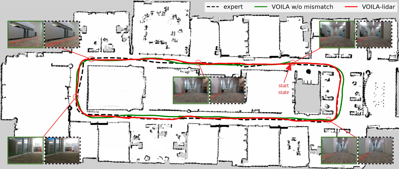
3.5.2.1 Learning a LiDAR-conditioned policy using VOILA
To evaluate whether voila supports sensing modalities other than vision in the navigation policy’s observation space (), we train voila with lidar range scan as the policy’s input, and observed that the agent learns to imitate the expert within 30 minutes of experiment time. As shown in Figure 3.7, in red, voila-lidar shows the rollout trajectory of the policy learned using voila with lidar range scans. The Hausdorff distance between trajectories of the corresponding expert demonstration and the different policies learned using voila are shown in Table 3.1. To provide context for the Hausdorff distance metric, we also show results for suboptimal and random trajectories. The suboptimal trajectory was collected by navigating along the hallway in a zig-zag route using move_base, and the random trajectory was collected using a randomly initialized policy , which fails quickly. We see that both voila policies performed well, and that the lidar-based policy provides better performance, which is consistent with findings by Torabi et al. (2018c) using gaifo.
In summary, in the physical experiments performed on the Jackal robot, we observed that 1) voila is indeed capable of learning imitative policies from video-only demonstrations even in the presence of significant viewpoint mismatch (addressing ), 2) a policy learned using voila does generalize to unseen environments (addressing ), and 3) voila does work with sensor modalities other than vision, such as lidar range scans (addressing ).
| Expert | Policy | Hausdorff Distance |
| human demo | voila w/ mismatch | 0.783 |
| move_base | voila-lidar w/o mismatch | 0.487 |
| move_base | voila w/o mismatch | 0.665 |
| move_base | Suboptimal | 0.806 |
| move_base | Random | 1.192 |
3.6 Summary
In this chapter, I introduced Visual-Observation-only Imitation Learning for Autonomous navigation (voila), a novel approach that enables imitation learning for autonomous robot navigation using a single, egocentric, video-only demonstration while being robust to egocentric viewpoint mismatch, thereby enabling navigation behaviors that are in alignment with the demonstrator. voila formulates the imitation problem as one of reinforcement learning using a novel reward function that is based on keypoint matches between the expert and imitator’s visual observations. Through experiments, both in simulation and on a physical robot, it is observed that, by optimizing the proposed reward function using reinforcement learning, voila could successfully find a good imitation policy that maps sensor observations directly to low-level action commands. Additionally, I show experiments that were performed to test the generalizability of policies trained using voila to unseen environments.
This chapter effectively concludes the first contribution of this dissertation, as outlined in Section 1.1, on visual end-to-end imitation learning for autonomous navigation. In the subsequent chapter, I delve into the second contribution focusing on terrain representation learning and the alignment of robot navigation behaviors with operator preferences in off-road autonomy.
Chapter 4 Preference-Aligned Off-Road Navigation
In this chapter, I introduce the second contribution of this dissertation, which comprises two algorithms, namely sterling (Karnan et al., 2023a) and patern (Karnan et al., 2023c). These algorithms enable aligning a mobile robot’s off-road navigation behavior with an operator’s terrain preferences in off-road conditions by leveraging self-supervised representation learning. The first algorithm, sterling, is focused on learning relevant terrain representations in a self-supervised manner, enabling operator-preference-conditioned mobile robot navigation in off-road environments. The second algorithm, patern, extends this concept through a self-supervised learning framework designed to extrapolate operator preferences onto visually novel terrains. The structure of this chapter is as follows. Section 4.1 introduces the specific problem this chapter addresses. Section 4.2 provides a review of relevant literature, followed by foundational concepts outlined in Section 4.3. Sections 4.4 and 4.5 present the two algorithmic contributions, sterling and patern respectively.
4.1 Introduction
Terrain awareness, defined as the ability to identify distinct terrain features that are relevant to a wide variety of downstream tasks (e.g., changing preferences over terrain types) is a particularly difficult challenge in off-road autonomous navigation (Karnan et al., 2023d; Yang et al., 2023; Sikand et al., 2022; Yao et al., 2022; Zürn et al., 2020; Karnan et al., 2022c; Atreya et al., 2022a; Karnan et al., 2022a). Existing approaches typically rely on difficult-to-collect curated datasets (Wigness et al., 2019; Jiang et al., 2020; Sharma et al., 2022; Guan et al., 2021; Triest et al., 2022) or have been focused on particular tasks (Bojarski et al., 2016; Lecun et al., 2005; Wulfmeier et al., 2015; Pan et al., 2018; Kahn et al., 2021b; Karnan et al., 2022c) and is not amenable to downstream task changes (Kahn et al., 2021a, b; Yao et al., 2022). These limitations prevent existing approaches from appropriately scaling to the vast distribution of terrains and navigation tasks in the real world.
This necessity for terrain awareness stems not only from direct implications for robot functionality but also from operator-indicated terrain preferences that the robot must adhere to. Often, these preferences are motivated by the desire the protect delicate landscapes, such as flower beds, or to mitigate potential wear and tear on the robot by avoiding hazardous surfaces. However, during autonomous operations, ground robots frequently face unfamiliar terrains (Karnan et al., 2022c; Miki et al., 2022a) and dynamic real-world conditions such as varied lighting that lie outside the distribution of visually recognized terrains where operator preferences have been pre-defined. This mismatch presents significant challenges for vision-based outdoor navigation (Xiao et al., 2020b).
Prior approaches to addressing the preference-aligned path planning problem include collecting expert demonstrations on diverse environments (Bojarski et al., 2016; Lecun et al., 2005; Sikand et al., 2022), gathering pixel-wise human annotations and labels for off-road data (Guan et al., 2021; Wigness et al., 2019; Jiang et al., 2020), and utilizing hand-coded reward functions to assign traversability costs (Yao et al., 2022; Kahn et al., 2021a; Sathyamoorthy et al., 2022). While these approaches have been successful at visual navigation, collecting expert demonstration data in the field and labeling may be labor-intensive and expensive, and utilizing hand-coded reward functions may not always align with operator preferences. We posit that in certain cases, while the terrain may look visually distinct in comparison to prior experience, similarities in the inertial-proprioceptive-tactile space may be leveraged to extrapolate operator preferences over such terrains that the robot must adhere to. For instance, assuming a robot has traversed both concrete pavement and marble rocks, and prefers the former over the latter (as expressed by the operator), when the robot experiences a visually novel terrain such as pebble pavement which feels inertially similar to traversing over concrete pavement, it is more likely that the operator might also prefer pebble pavement over marble rocks. While it is not possible to know the operator’s true preferences without querying them, we submit that, in cases where the operator is unavailable, hypothesizing preferences through extrapolation from the inertial-proprioceptive-tactile space is a plausible way to estimate traversability preferences for novel terrains.
First, toward overcoming the scalability challenge in learning to be terrain aware, we introduce Self-supervised TErrain Representation LearnING (sterling),111A preliminary version of this work was presented at the PT4R workshop at ICRA 2023 (Karnan et al., 2023b). The final version was presented at CoRL 2023 (Karnan et al., 2023a). a novel approach to learning terrain representations for off-road navigation. sterling learns an encoding function that maps high-dimensional, multi-modal sensor data to low-dimensional, terrain-aware representations that amplify differences important for navigation and attenuate differences due to extraneous factors such as changes in viewpoint and lighting. Importantly, sterling works with easy-to-collect unconstrained and unlabeled robot data, thereby providing a scalable pathway to data collection and system improvement for the wide variety of terrain and downstream tasks that off-road robots must face. To evaluate sterling, we apply it to the problem of preference-aligned off-road navigation and provide a detailed comparison to existing approaches to this problem, including rca (Yao et al., 2022), ganav (Guan et al., 2021), ser (Zürn et al., 2020), and a fully-supervised oracle. We find that sterling enables performance on par with or better than these existing approaches without requiring any expert labels or demonstrations. Additionally, we report the results of a large-scale qualitative experiment in which sterling enabled semi-autonomous robot navigation on a 3-mile long hiking trail.
Second, leveraging the intuition of extrapolating operator preferences for visually distinct terrains that are familiar in the inertial-proprioceptive-tactile space (collectively known as proprioceptive for brevity), we introduce Preference extrApolation for Terrain-awarE Robot Navigation (patern), 222patern is accepted for publication at ICRA 2024. a novel framework for extrapolating operator terrain preferences for visual navigation. patern learns a proprioceptive latent representation space from the robot’s prior experience and uses nearest-neighbor search in this space to estimate operator preferences for visually novel terrains. Figure 4.1 provides an illustration of the intuition behind preference extrapolation in patern. We conduct extensive physical robot experiments on the task of preference-aligned off-road navigation, evaluating patern against state-of-the-art approaches, and find that patern is empirically successful with respect to preference alignment and in adapting to novel terrains and lighting conditions seen in the real world. 333The research described in this chapter was done in collaboration with Elvin Yang, Daniel Farkash, Garrett Warnell, Joydeep Biswas, and Peter Stone.
Relation between STERLING and PATERN: sterling is a self-supervised representation learning algorithm designed to learn terrain representations solely from a robot’s unconstrained experiences that can better enable the downstream task of operator preference-aligned off-road navigation. To gather preferences, however, sterling necessitates gathering operator feedback for each new terrain that the robot encounters which may not always be feasible. patern, in contrast, addresses this gap by leveraging a simple intuition. Instead of querying an operator for all new terrains encountered, patern complements sterling by inferring preferences through extrapolation from known to visually novel terrains, utilizing non-visual terrain data observed by the robot. sterling is most effective in cases where the robot is unlikely to come across terrains beyond its training set, or where operator preferences are readily obtainable. However, in situations where the robot may face visually novel terrains or obtaining operator feedback for novel terrains is challenging, patern is a necessary extension to sterling that enables extrapolating operator preferences, thereby complementing sterling and reducing the dependence on direct operator feedback. Therefore, patern does not completely replace sterling, however, it acts as a wrapper over sterling, extending its capabilities beyond the observed set of terrains. To summarize, sterling is a self-supervised terrain representation learning algorithm that utilizes operator feedback of preferences for all encountered terrains to enable preference-aligned off-road navigation, whereas patern complements sterling by deducing operator preferences for certain visually novel terrains, thereby reducing the dependency on direct operator feedback.
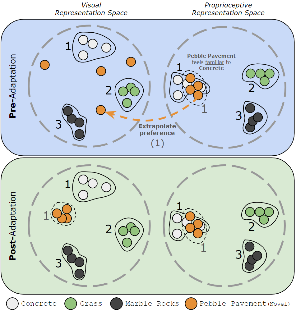
4.2 Related Work
In this section, I review related work on terrain-aware visual off-road navigation. I specifically focus on approaches that learn to navigate off-road conditions using supervised and self-supervised learning with a focus on operator-preference-aligned planning.
4.2.1 Supervised Methods
Several approaches in the past have proposed using supervised learning from large-scale data to navigate off-road environments. We divide them into two categories as follows.
End-to-End Learning: The initial success of applying learning-based solutions to off-road terrain-aware navigation was by Lecun et al. (2005) who used a convolutional network to learn to drive in off-road conditions. More recently, Bojarski et al. (2016) trained a deep neural network end-to-end using several miles of driving data collected on a vehicle in the real world. While both approaches were promising in urban and off-road environments, end-to-end methods require large amounts of data and are well-known to suffer from domain and covariate shifts (Xiao et al., 2020b; Karnan et al., 2021; Xiao et al., 2022a).
Image Segmentation: Unlike end-to-end approaches that learn behaviors, segmentation-based approaches seek to characterize terrain using a set of known semantic classes, and the resulting semantic features are consumed by downstream planning and control techniques for navigation (Schilling et al., 2017; Guan et al., 2021; Wigness et al., 2018). Guan et al. (2021) propose ganav, a transformer-based architecture to pixel-wise segment terrains, trained on rellis (Jiang et al., 2020) and rugd (Wigness et al., 2019) datasets, with manually assigned terrain costs. While effective at terrain awareness, segmentation-based methods are fixed to the specific terrain types available in the datasets and require additional labeling effort to generalize to novel terrains. On the other hand, sterling does not require semantically labeled datasets and learns terrain representations from unconstrained experience collected onboard a mobile robot.
4.2.2 Self-Supervised Learning
To alleviate the need for extensive human labeling, self-supervised learning methods have been proposed to either learn terrain representations or costs from data gathered onboard a mobile robot.
Representation Learning: Brooks and Iagnemma (2007) utilize contact vibrations and visual sensors to classify terrains via self-supervision. Loquercio et al. (2022) use proprioceptive supervision to predict extrinsic representations (Karnan et al., 2022d) of terrain geometry from vision, used as inputs to drive a Reinforcement Learning-based locomotion policy. In both contributions in this Chapter, we do not learn a robot-specific locomotion policy and instead learn relevant representations for off-road terrain awareness. Zürn et al. (2020) introduce ser which utilizes acoustic and visual sensors on the robot to segment terrains using a self-supervised triplet-contrastive learning framework. Using triplet-based contrastive learning methods requires negative samples which may not be available when learning using unlabeled data. In sterling, I propose using non-contrastive unsupervised learning approaches known as vicreg (Bardes et al., 2021) that do not require any negative samples and instead rely on correlations between data modalities to learn relevant terrain representations.
Cost Learning: Several methods have applied self-supervision to assign traversability costs for the downstream off-road navigation task (Yao et al., 2022; Sathyamoorthy et al., 2022; Kahn et al., 2021a; Wellhausen et al., 2019; Castro et al., 2023; Triest et al., 2023; Chen et al., 2023). Specifically, these methods rely on inertial spectral features (Yao et al., 2022), future predictive models (Kahn et al., 2021a), inertial-odometry errors (Sathyamoorthy et al., 2022), or force-torque values from foothold positions (Wellhausen et al., 2019, 2020) as self-supervision signals to learn a traversability cost map, used to evaluate candidate actions. More recently, Frey et al. (2023) proposed an online traversability estimation approach inspired by the above self-supervision schemes. Instead of inferring costs or rewards using self-supervision for a fixed task, the first contribution in this chapter, sterling, focuses on learning relevant visual features from unconstrained robot experiences that could be used in downstream tasks. This framework allows a designer to reuse features across tasks without retraining entirely from scratch. Additionally, contrasting with prior methods using hand-coded reward/cost functions that may not adhere to operator preferences, patern utilizes the prior experience of the robot and extrapolates operator preferences to novel terrains.
Hybrid Methods: The approach closest to ours is vrl-pap (Sikand et al., 2022) which requires human expert teleoperated demonstrations of a particular trajectory pattern to both explicitly learn visual terrain representations as well as to infer terrain preference costs. However, the first contribution in this chapter, sterling, focuses on learning terrain features from unconstrained robot experiences without requiring human experts in the field for demonstrations, which is a more general problem than the one considered by vrl-pap. Additionally, patern focuses on extrapolating operator preferences without additional human feedback, which is not supported in vrl-pap.
4.3 Preliminaries
We formulate preference-aligned planning as a local path-planning problem in a state space , with an associated action space . The forward kino-dynamic transition function is denoted as and we assume that the robot has a reasonable model of (e.g., using parametric system identification (Seegmiller et al., 2013) or a learned kino-dynamic model (Xiao et al., 2021; Karnan et al., 2022c; Atreya et al., 2022b)), and that the robot can execute actions in with reasonable precision. For ground vehicles, a common choice for is , which represents the robot’s x and y position on the ground plane, as well as its orientation .
The objective of the path-planning problem can be expressed as finding the optimal trajectory to the goal , using any planner (e.g. a sampling-based motion planner like dwa (Fox et al., 1997a)) while minimizing an objective function , . Here, denotes a sequence of states. The sequence of states in the optimal trajectory is then translated into a sequence of actions, using a 1-D time-optimal controller, to be played on the robot. For operator preference-aligned planning, the objective function is articulated as,
| (4.1) |
Here, denotes cost based on proximity of the robot’s state to the goal , while imparts a cost based on terrain preference. Crucially, is designed to capture operator preferences over different terrains; less preferred terrains incur a higher cost. Earlier studies such as vrl-pap (Sikand et al., 2022) leverage human feedback in the form of geometrically constrained trajectories to ascertain . In the contributions of this chapter, I utilize a two-step framework to determine . In the first contribution of this chapter as detailed in Section 4.4, sterling uses a self-supervised training recipe to first learn relevant terrain representations followed by operator preference queries to learn a mapping from visual observations of terrains to representations followed by a mapping from representations to preference cost value, used for planning. In the second contribution detailed in Section 4.5, patern extrapolates preference values of known terrains to visually novel terrains through a self-supervised learning process.
4.4 Self-Supervised Terrain Representation Learning
In this section, I introduce sterling, a new approach for finding terrain representations using self-supervised learning. I first describe the offline pre-processing performed on unconstrained robot data and then summarize the self-supervision objectives. Finally, I describe the problem formulation for preference-aligned off-road navigation and present how features learned using sterling can be utilized within a planner for terrain-aware and preference-aligned navigation.
4.4.1 Data-Collection and Pre-Processing
sterling learns terrain representations from unconstrained, unlabeled robot experiences collected using any navigation policy. This policy may be, for instance, non-expert human teleoperation, curiosity-driven exploration (Pathak et al., 2017), or point-to-point navigation using any underlying planner. Compared to requiring a human expert to provide teleoperated demonstrations and labels, collecting this type of robot experience is cheap and easy, thereby providing a scalable pathway to data collection and system improvement. We additionally assume that the robot is equipped with multiple sensors, e.g., an egocentric RGB camera, odometry sensors, onboard IMU, proprioceptive, and tactile sensors, that together provide rich multi-modal observations as the robot traverses over different terrains collecting experience. sterling leverages this multi-modal data by using the correlation between different modalities to inform the learned terrain representations.
In order to learn terrain representations using sterling, we begin by pre-processing the visual and non-visual observations, which are explained in detail below.
Visual Patch Extraction: The egocentric camera observations are homography-projected into a virtual bird’s eye view (BEV) frame, assuming that the ground is a flat plane, using the intrinsic and extrinsic camera matrices. As shown in Figure 4.2, we project the robot’s trajectory onto the BEV frame and extract 64-by-64 pixels (equivalent to the robot’s footprint of 0.5-by-0.5 meters) square visual patches of terrain along with the corresponding inertial, proprioceptive, and tactile observations at the same location, along the trajectory. Since the terrain at is unobservable when the robot itself is at (i.e., it is underneath the robot), we extract terrain image patches corresponding to from BEV observations at previous locations along its trajectory. Figure 4.2 illustrates the offline patch extraction process from two previous viewpoints, however, we extract patches from up to 20 previous viewpoints within 2 meters. Although just one viewpoint is sufficient to learn the correlation between visual and other sensor observations, when planning to navigate, the robot will need to visually evaluate terrain at future locations, and therefore sterling also seeks representations that are invariant to patch differences due to viewpoint, also known as viewpoint invariance.
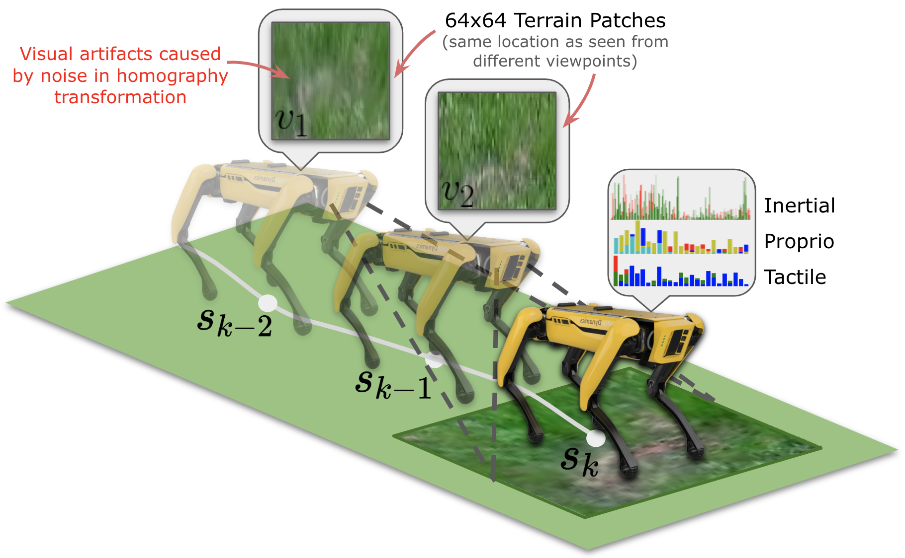
IPT Pre-Processing: For the inertial, proprioceptive, and tactile (ipt) observations, we retain up to 2-second history and convert the time-series signals into power-spectral density (psd) representation in the frequency domain. This ensures the ipt time-series data representations used as input to sterling are invariant to differences in length and phase in the recorded signals.
Data Collection: In all experiments, we use a legged Boston Dynamics Spot robot and collect robot experiences on eight different types of terrain around the university campus that we labeled as mulch, pebble sidewalk, cement sidewalk, grass, bushes, marbled rock, yellow bricks, and red bricks. The data is collected through human teleoperation such that each trajectory contains a unique terrain throughout, with random trajectory shapes. Note that sterling does not require a human expert to teleoperate the robot to collect robot experience nor does it require the experience to be gathered on a unique terrain per trajectory. We follow this data collection approach since it is easier to label the terrain for evaluation purposes. sterling can also work with random trajectory lengths, with multiple terrains encountered along the same trajectory, without any semantic labels such as terrain names, and any navigation policy can be used for data collection. We record 8 trajectories per terrain, each five minutes long, and use 4 trajectories for training and the remaining for validation.
4.4.2 Sampling-based Planning
We assume access to a receding horizon sampling-based motion planner with a fixed set of constant-curvature arcs , which solves for the optimal arc , minimizing the objective function . For the task of preference-aligned off-road navigation, we assume the objective function is composed of two components and , and can be defined as . is the geometric cost that deals with progress towards the goal and avoiding geometric obstacles, whereas is the terrain cost associated with preference-alignment. We utilize the geometric cost as defined in AMRL’s graph navigation stack 444https://github.com/ut-amrl/graph_navigation. The multiplier trades off relative contributions of the geometric and terrain preference components of the path planning objective. A 1D time-optimal controller translates the sequence of states in the optimal trajectory to a sequence of receding horizon actions . For a given arc , such that state is closest to the robot, the terrain-preference cost can be computed as follows.
| (4.2) |
The function maps from RGB space of a visual patch of terrain at a specific state , to its visual representation . For instance, can be the visual encoder learned using sterling, as described in Section 4.4.3. The utility function maps the visual representation of a patch of terrain to a real-valued utility of preferences. We follow the utility function formulation of Zucker et al. (2011) and assume the terrain preference cost follows a multiplicative formulation such that given a utility value , the traversability cost is . The discount factor weighs the terrain cost proportional to its proximity to the robot. We set to , which we find to work well in practice.
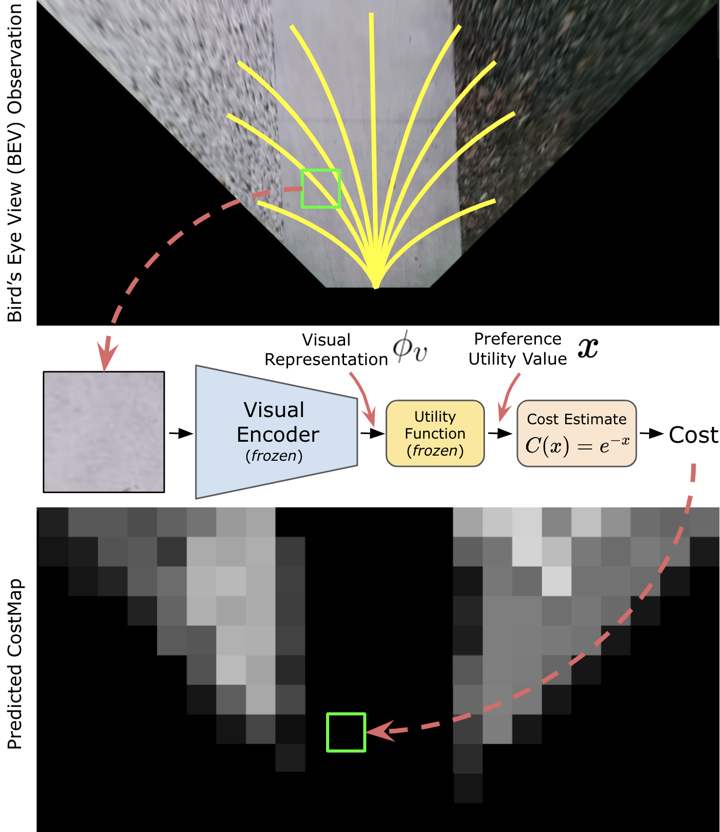
Planning at Deployment: Figure 4.3 provides an overview of the cost inference process for local planning at deployment. To evaluate the terrain cost for the constant-curvature arcs, we overlay the arcs on the bird’s eye view image, extract terrain patches at states along the arc, and compute the cost according to Equation 4.2. We compute the visual representation, utility value, and terrain cost of all images at once as a single batch inference. Since the visual encoder and the utility function are relatively lightweight neural networks with about 0.5 million parameters, we are able to achieve real-time planning rates of 40 Hz using a laptop-grade Nvidia GPU.
4.4.3 Non-Contrastive Terrain Representation Learning
It is desired for learned representations of terrains to be such that representations of similar terrain are close together in the embedding space and that representations of different terrains are sufficiently far apart. Although we do not possess privileged information such as semantic labels of terrains for training, the visual and kinodynamic observations experienced by the robot reflect similarities and differences between terrain samples. For instance, traversing a smooth terrain that a human may refer to as cement sidewalk may lead to relatively smooth motion by the robot’s joints, whereas a rough terrain such as what might be referred to as marble rocks may correspond to jerkier motion. sterling leverages this multi-modal experience observed by the robot and computes a correlation objective between visual and inertial-proprio-tactile signals to learn desired terrain representations. Additionally, sterling uses viewpoint invariance as an objective unique to the visual component of the experience to learn viewpoint-invariant terrain representations.
Figure 4.4 provides an overview of the self-supervised representation learning framework adopted in sterling. A parameterized visual encoder (4-layer CNN with 0.25 million parameters) encodes terrain image patch observations and of the same location into visual representations and , respectively, collectively referred to as for brevity. Similarly, an inertial-proprio-tactile encoder (4-layer MLP with 0.25 million parameters) encodes frequency domain ipt observations of the robot at that location to an inertial-proprio-tactile representation . We follow the framework of prior self-supervised representation learning algorithms from the computer vision community such as vicreg (Bardes et al., 2021), and utilize a parameterized projector network (2-layer MLP with 0.25 million parameters) that maps encoded visual and non-visual representations independently to a higher-dimensional feature space and respectively, over which the self-supervision objectives are computed. The sterling objective composed of the multi-modal correlation and viewpoint-invariance objectives are defined as:
| (4.3) | ||||
is the vicreg loss that is composed of variance-invariance-covariance representation learning objectives, as proposed by Bardes et al. (2021). Given two alternate projected representations and of a data sample (in sterling, and are projected representations of the visual and non-visual sensor modalities), the vicreg loss is defined as . Note that while Bardes et al. (2021) use vicreg to learn representations from visual inputs using artificial image augmentations, in this work, we extend vicreg to multi-modal inputs and use real-world augmentations via multi-viewpoint image patches as described in Section 4.4.1. , , and are hyper-parameters and the functions , , and are the variance, invariance, and covariance terms computed on a mini-batch of projected features. We refer the reader to Bardes et al. (2021) for additional details on the individual terms and also define them here for completeness. The variance term is a hinge function defined as , where is the standard deviation, and is the dimensionality of the projected feature space. is the covariance term, defined as , where is the covariance matrix of . is the invariance term defined as .
While the foundational work by Bardes et al. (2021) uses image augmentations to learn visual representations in a self-supervised way, we utilize images from multiple viewpoints and multi-modal inputs such as vision, inertial, proprioceptive, tactile using a novel formulation to learn relevant terrain representations in a self-supervised way. The sterling loss based on vicreg is defined in Section 4.4.3. The vicreg loss is defined as , where , and are hyperparameters. We use the values 25.0, 25.0, 1.0 for these hyperparameters respectively, as suggested by Bardes et al. (2021). denotes the invariance between the two inputs. In sterling, this invariance term is computed across the two image patches from different viewpoints, and also between the visual and non-visual (ipt) projections. denotes the variance across the batch dimension, which we compute for the projections of individual patches and the ipt signals. denotes the covariance across the feature dimension which encourages distinct, non-correlative features which we again compute for the projections of individual patches and the ipt signals. We apply an norm on the visual and non-visual features to ensure they are on a hypersphere, which helps improve the quality of learned representations. On a mini-batch of data containing paired terrain image patches and ipt observations, we compute the loss and update parameters of the two encoder networks and the shared projector network together using Adam optimizer.
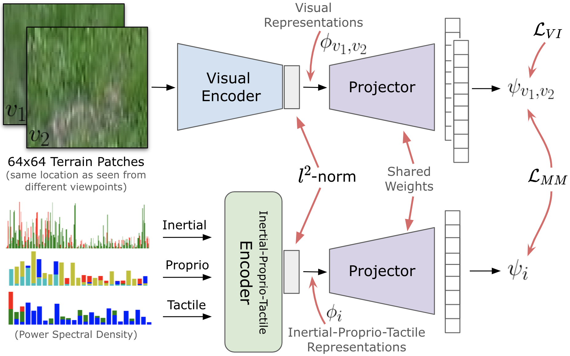
4.4.4 Preference-Aligned Off-Road Navigation
In this section, I describe the downstream navigation task of preference-aligned visual navigation that we focus on when evaluating sterling.
Preliminaries: We formulate the task of preference-aligned terrain-aware navigation as a local path-planning problem, where the robot operates within a state space , action space , and a deterministic transition function in the environment. The state space consists of , where denote the robot’s position in space, and denotes the visual features of the terrain at this location. Given a goal location , the preference-aligned navigation task is to reach this goal while adhering to operator preferences over terrains. We assume access to a sampling-based planner, the details of which are provided in Section 4.4.2.
Learning the preference utility: Following Zucker et al. (2011), we learn the utility function using human queries. From the predicted terrain features on data samples in our training set, we cluster the terrain representations using k-means with silhouette-score elbow criterion, and sample candidate terrain patches from each cluster, which is presented to the human operator using a GUI. The human operator then provides a full-order ranking of terrain preferences over clusters, which is utilized to learn the utility function , represented by a 2-layer MLP. While recovering absolute cost values from ranked preference orders is an under-constrained problem, we find that this approximation provided by Zucker et al. (2011) works well in practice.
4.4.5 Experiments
In this section, I describe the experiments performed to evaluate sterling. Specifically, the experiments presented in this section are tailored to address the following questions:
-
()
How effective are sterling features in comparison to baseline approaches at enabling terrain awareness in off-road navigation?
-
()
How effective are the proposed sterling objectives in learning discriminative terrain features in comparison to other representation learning objectives?
We investigate through physical robot experiments on the task of preference-aligned off-road navigation. We perform quantitative evaluations in six different outdoor environments, and then further perform a large-scale qualitative evaluation by semi-autonomously hiking a 3-mile long off-road trail using preference costs learned using sterling features. To compare various methods, we use the success rate of preference alignment as a metric. If a trajectory followed by any algorithm fails to reach the goal, or at any time traverses over any terrain that is less preferred than any traversed by the operator-demonstrated trajectory, we classify the trial as a failure. We additionally investigate by comparing sterling against other unsupervised terrain representation learning methods and perform an ablation study on the two sterling objectives.
Baselines: To perform quantitative evaluations for , we compare sterling with ser (Zürn et al., 2020), rca (Yao et al., 2022), ganav (Guan et al., 2021), geometric-only planning (Biswas, 2013), and a fully-supervised baseline. ser and rca perform self-supervised learning from unconstrained robot experience to learn terrain representations and traversability costs respectively, making them relevant baselines for this problem. Since there is no open-source implementation of rca, we replicate it to the best of our abilities. The geometric-only approach ignores terrain costs () and plans with geometric cost () only, making it a relevant ablation on the cost formulation for preference-aware planning. ganav555https://github.com/rayguan97/GANav-offroad (Guan et al., 2021) is a segmentation-based approach trained on the RUGD (Wigness et al., 2019) dataset. We additionally train the fully-supervised baseline in which the terrain cost function is learned end-to-end using supervised learning from linear extrapolation of operator preferences. ganav and the fully-supervised baseline require supervision via terrain labels to learn and hence serve as references for comparison. We normalize the terrain cost predicted by all methods to be between 0 and 1 for a fair comparison.
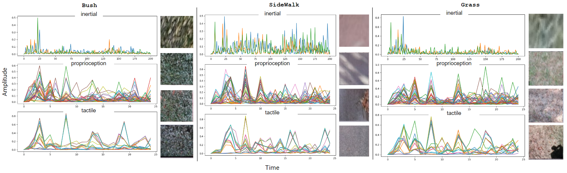
4.4.5.1 Experimental Setup and Methodological Details
In this subsection, we outline the specifics of our experimental setup, detailing hyperparameters, architectural decisions, data, and sensory inputs. These insights ensure the clarity and reproducibility of our experiments.
In all experiments in sterling, including the baselines rca and ser, we use a shallow 4-layer CNN with a kernel size of 3 and stride of 1. Our choice of a shallow 4-layer CNN was driven by the specific need for a lightweight and efficient model that could operate in real time at 40Hz on a laptop GPU, a requirement that was effectively met with this simple architecture of 0.25 M parameters, which we found was sufficient for the problem. While modern architectures like vision transformers / Mobile-ViT could be applied with larger-scale data, the primary concern was real-time performance and compatibility with our robot’s hardware. Our experiments and results demonstrate that the selected architecture was sufficient for the purpose, and we do not find evidence that our approach’s effectiveness is constrained by this architectural choice.
To train sterling, ser, and rca, we used a total of 117,604 data samples for all terrains combined. Example raw time-series sensor data is shown in Figure 4.5. Each data sample contains a minimum of 2 visual patches and a maximum of 20 visual patches of the same location from multiple different viewpoints from which we randomly sample 2 patches per location during training. We convert the time-series ipt signals into their corresponding Power Spectral Density psd values. Power spectral density describes the power of a signal across different frequency components. To compute this, we perform a fast-fourier transform over the time-series signal (inertial/proprioceptive/ tactile) and compute the psd defined as across each frequency component .
On the Spot robot, we use a VectorNav IMU to record the inertial signals (angular velocities in the x and y-axis and linear acceleration in z-axis) at 200Hz, the joint angles and velocities of the legged robot, referred as proprioceptive feedback in this work are recorded at 25 Hz, and the feet contact measurements (contact booleans and estimated feet depth from ground) collectively referred to as tactile feedback in this work are recorded at 25Hz. An Azure kinect camera is mounted on the Spot, used for visual sensing of the terrain. On the wheeled Clearpath Jackal robot, we use a Zed2 camera for visual sensing, and utilize the internal IMU sensor for inertial feedback. Figure 4.6 depicts the two robots, sensor mounts, and other sensors used in this work.
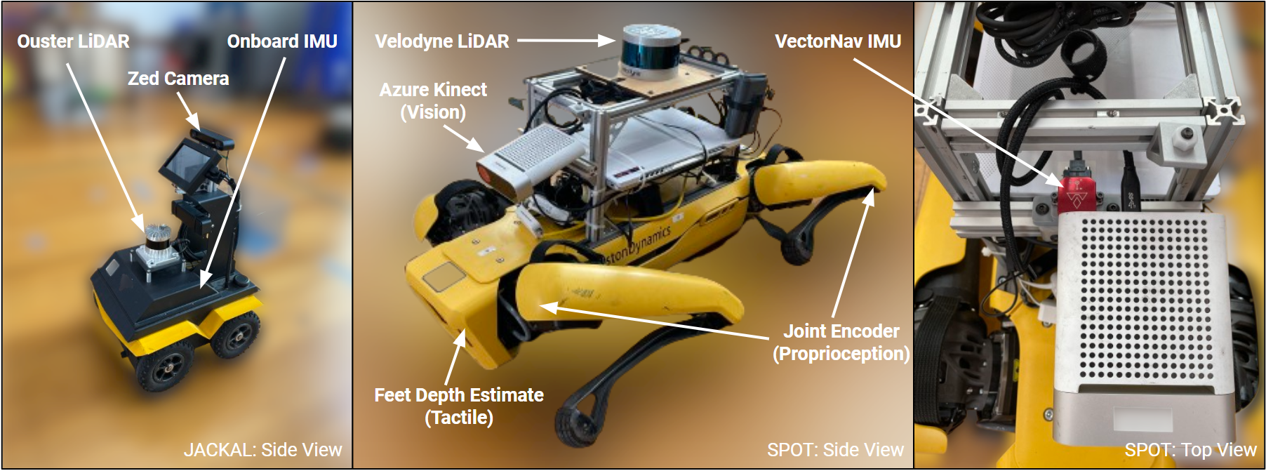
Note that in all experiments, to prevent overfitting to a specific environment, we pretrain the visual encoder and utility function once and deploy them in all environments. The encoders and utility functions are not being retrained/finetuned per environment, including the large-scale outdoor trail.
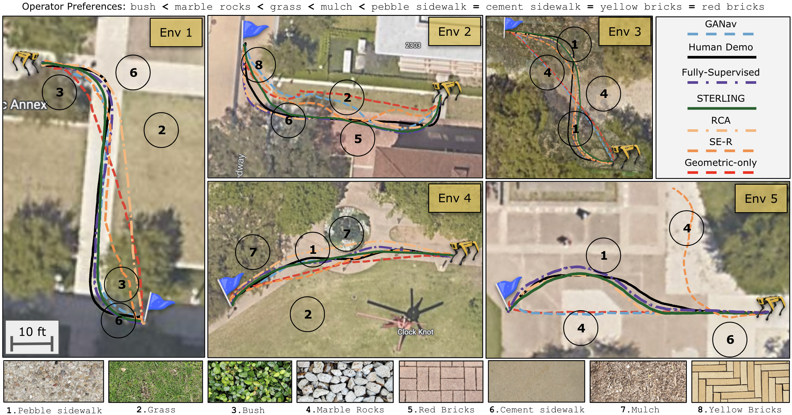
| Hyperparameter | Value/Range |
| Learning Rate | |
| Batch Size | 128 |
| Number of Epochs | 50 |
| Optimizer | Adam |
| Weight Decay | |
| Activation Function | ReLU |
| Kernel Size | 3 |
| Stride | 1 |
4.4.5.2 Evaluating Terrain-Awareness via Robot Experiments
In this subsection, we report on experiments to investigate the effectiveness of sterling features in enabling terrain awareness during off-road navigation. We quantitatively compare the performance of sterling with baselines rca (Yao et al., 2022), ganav (Guan et al., 2021), ser (Zürn et al., 2020) and the fully-supervised baseline, on the task of preference-aligned navigation. We identify six environments within the university campus, with eight different terrain types, as shown in Figure 4.7. For this study, we use the same data collected on the robot to train rca, ser, fully-supervised baseline, and sterling, and the operator provides the same rankings for all methods during training. Note that we use the same encoder and utility function across all environments and do not retrain/finetune to each environment to prevent environment-specific overfitting.
Figure 4.7 shows the operator’s terrain preferences for all Environments 1 to 5, and the performance of baseline approaches, including an operator-demonstrated trajectory for reference. In all environments, we see that sterling navigates in a terrain-aware manner while adhering to the operator’s preferences. Note that although Fully-Supervised also completes the task successfully, it requires privileged information such as terrain labels during training, whereas sterling does not require such supervision, and can potentially be used on large datasets containing unlabeled, unconstrained robot experiences. ganav, trained on the rugd dataset fails to generalize to unseen real-world conditions. rca uses inertial spectral features to learn terrain traversability costs and hence does not adhere to operator preference. ser does not address viewpoint invariance which is a significant problem in vision-based off-road navigation and hence performs poorly in Environments 1 and 2. We perform additional experiments in an outdoor environment (Environment 6) to study adherence to operator preferences, detailed in Section 4.4.5.4.
Table 4.2 shows the success rate of preference alignment for all approaches in all environments, over five different trials. sterling outperforms other self-supervised baselines and performs on par with the fully-supervised approach. In summary, the physical experiments conducted in six environments quantitatively demonstrate the effectiveness of sterling features in enabling terrain awareness during off-road navigation.
| Approach | Environment | ||||||
| 1 | 2 | 3 | 4 | 5 | 6 (a) | 6 (b) | |
| Geometric-only | 0/5 | 0/5 | 0/5 | 0/5 | 0/5 | 0/5 | 5/5 |
| rca(Yao et al., 2022) | 2/5 | 4/5 | 2/5 | 0/5 | 1/5 | 5/5 | 0/5 |
| ganav(Guan et al., 2021) | 5/5 | 0/5 | 0/5 | 5/5 | 0/5 | 4/5 | 5/5 |
| ser(Zürn et al., 2020) | 1/5 | 0/5 | 5/5 | 1/5 | 3/5 | 5/5 | 4/5 |
| Fully-Supervised | 5/5 | 5/5 | 5/5 | 5/5 | 5/5 | 5/5 | 5/5 |
| sterling (Ours) | 5/5 | 5/5 | 5/5 | 5/5 | 5/5 | 5/5 | 5/5 |
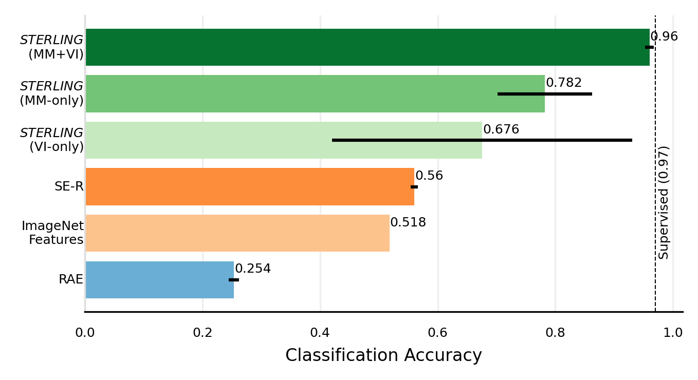
4.4.5.3 Evaluating Self-Supervision Objectives
In this subsection, we investigate the effectiveness of sterling at learning discriminative terrain features and compare with baseline unsupervised terrain representation learning methods such as Regularized Auto-Encoder (rae) and ser (Zürn et al., 2020) and large pretrained networks such as a ResNet-50 pretrained on ImageNet. sterling uses multi-modal correlation () and viewpoint invariance () objectives for self-supervised representation learning, whereas, ser and rae use soft-triplet-contrastive loss and pixel-wise reconstruction loss, respectively. Additionally, we also perform an ablation study on the two objectives in sterling to understand their contributions to learning discriminative terrain features. To evaluate different visual representations, we perform unsupervised classification using k-means clustering and compare their relative classification accuracies with manually labeled terrain labels. For this experiment, we train sterling, ser, and rae on our training set and evaluate on a held-out validation set. Figure 4.8 shows the results of this study. We see that sterling-features using both the self-supervision objectives perform the best among all methods. Additionally, we see that using a non-contrastive representation learning approach such as vicreg (Bardes et al., 2021) within sterling performs better than contrastive learning methods such as ser, and reconstruction-based methods such as rae. This study shows that the proposed self-supervision objectives in sterling indeed help learn discriminative terrain features.
4.4.5.4 Preference Alignment Evaluation
In addition to the evaluations of sterling-features with baseline approaches in five environments as shown in Section 4.4.5, we utilize Environment 6 to further study adherence to operator preferences. We hypothesize that the discriminative features learned using sterling is sufficient to learn the preference cost for local planning. To test this hypothesis, in Environment 6 containing three terrains as shown in Figure 4.9, the operator provides two different preferences 6(a) and 6(b). While bush is the least preferred in both cases, in 6(a), sidewalk is more preferred than grass and in 6(b), both grass and sidewalk are equally preferred. We see in Figure 4.9 that using sterling features, the planner is able to sufficiently distinguish the terrains and reach the goal while adhering to operator preferences. Although ser (Zürn et al., 2020) adheres to operator preference in 6(b), it incorrectly maps grass to bush, assigning a higher cost and taking a longer route to reach the goal. On the other hand, rca (Yao et al., 2022) fails to adhere to operator preferences since it directly assigns traversability costs using inertial features.
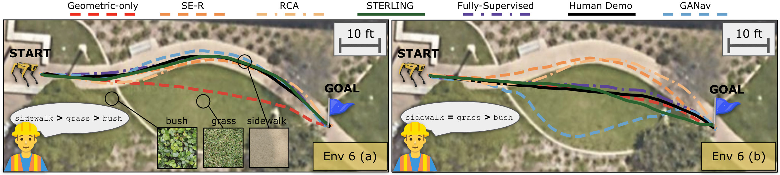
4.4.5.5 Large-Scale Qualitative Evaluation
In this subsection, we perform a qualitative evaluation of sterling by reporting a large-scale study of semi-autonomously hiking a 3-mile-long off-road trail using the Spot robot.
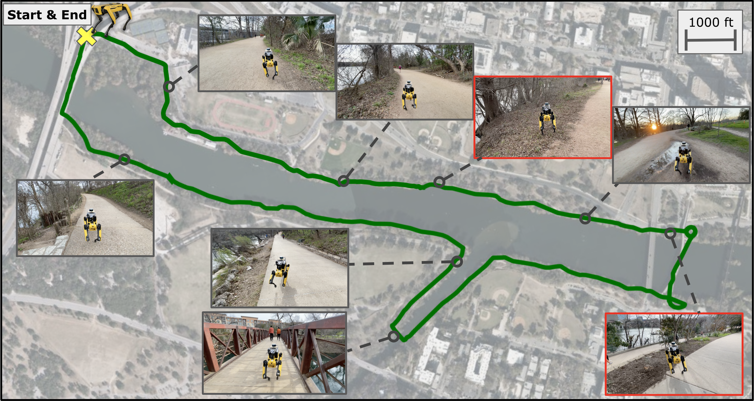
We train sterling using unconstrained robot experience collected within the university campus and train the preference utility function using operator-provided preferences: marble rocks < grass < dirt = cement. The task is to navigate the trail without a global map while adhering to operator preferences at all times. Since we do not use a global map, visual terrain awareness is necessary to navigate within the trail and avoid catastrophic events such as falling into the river next to the trail. We set a moving goal of six meters in front of the robot, updated every second. While the robot navigates autonomously, the operator walks behind the robot and takes manual control only to correct the robot’s path during forks, or to yield to incoming pedestrians and pets.666 A video of the robot navigating the trail successfully while avoiding less preferred terrains can be accessed here: https://youtu.be/dQb1XzocdtE. The robot needed two manual interventions while traversing along the trail. Figure 4.21 shows the 3-mile trajectory traced by the robot and the two failure cases that required manual intervention. This large-scale qualitative experiment demonstrates the reliability of sterling during real-world off-road deployments.
4.4.5.6 Experiments on a Wheeled Mobile Robot
sterling is intended as a general algorithm to learn relevant terrain representations for off-road navigation. Towards demonstrating the versatility of sterling to being applied to robots of different morphology, we conduct two additional experiments on the Clearpath Jackal, a wheeled mobile robot.
Learning Representations on Wheeled Robots: We utilize unconstrained data collected on the Jackal consisting of multi-modal visual and inertial sensor data and learn terrain representations using sterling followed by a utility function of operator preferences. Figure 4.11 (sterling-Jackal) shows the path traversed by the Jackal in Environment 6, following the human preference . This experiment demonstrates the applicability of sterling on wheeled robots with inertial sensors, as against legged robots that have access to additional sensors such as joint encoders and tactile information.
Zero-Shot Cross-Morphology Transfer: In a noteworthy experiment to evaluate the transferable property of terrain representations across robot morphologies, we utilized the visual encoder trained on data from the legged Spot robot and applied it on the wheeled Jackal robot without additional fine-tuning. Figure 4.11 (sterling-Spot) showcases the Jackal’s trajectory, leveraging sterling representations learned from Spot’s data, and adhering to the operator’s terrain preference: . Figure 4.13 shows costmaps generated using sterling features, used by the sampling-based planner to navigate in an operator-aligned manner. This demonstrates sterling’s capability to generalize across diverse robotic platforms, emphasizing its adaptability and broad applicability.
Figure 4.12 shows a third-person view of the deployment of sterling-Jackal in Environment 6. In both experiments above, we see the Jackal robot reaches the goal successfully while adhering to human operator preferences, in a terrain-aware manner, highlighting sterling’s adaptability regardless of robot morphology.
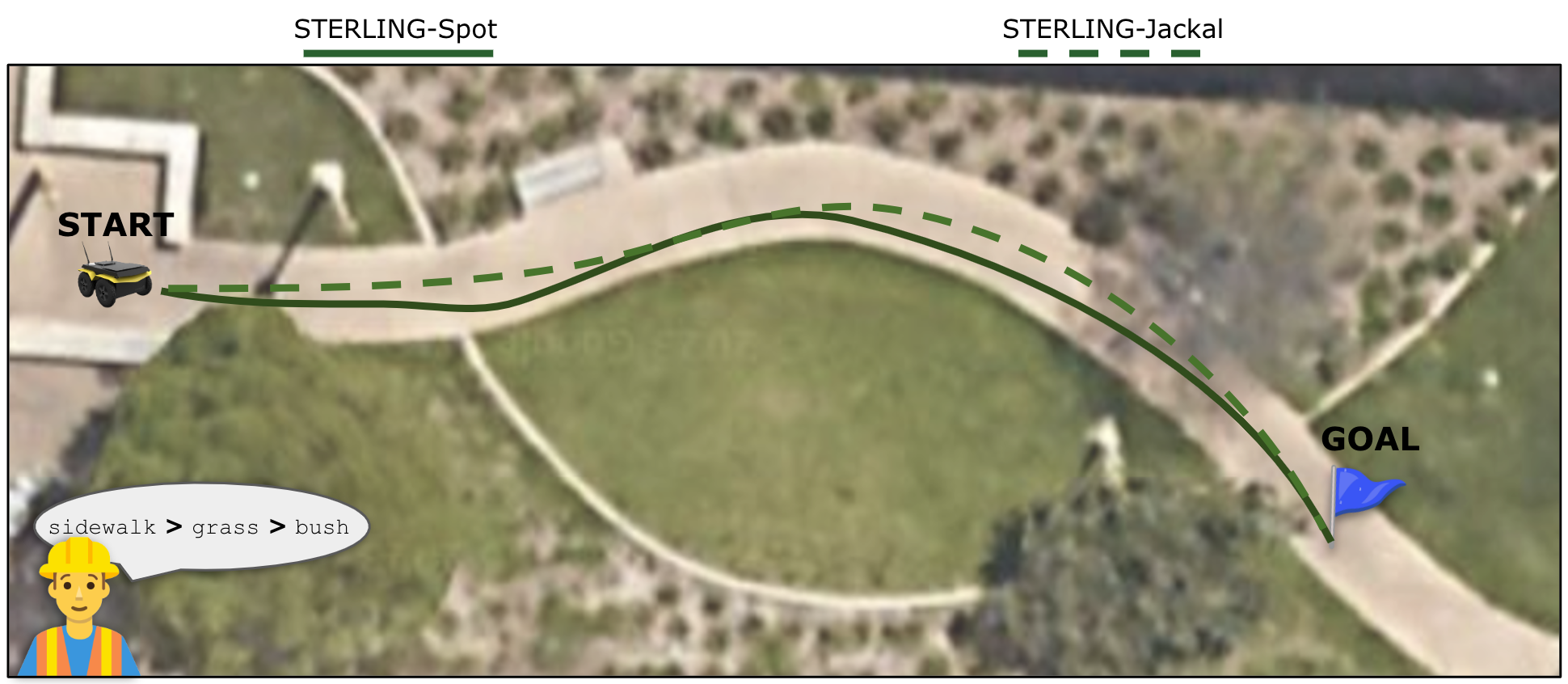
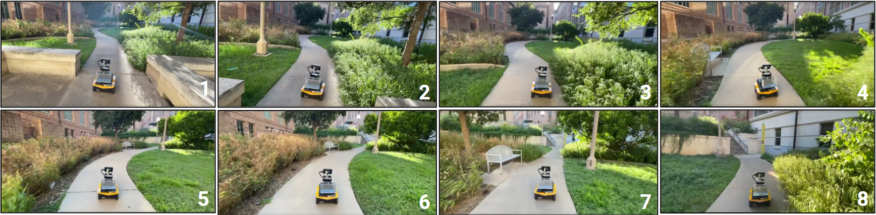
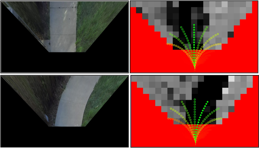
4.4.5.7 Visualizing the learned terrain representations
Figure 4.14 depicts a t-SNE visualization of terrain representations learned using sterling. Individual patches are color-coded by their ground truth semantic terrain label. We see that sterling learns relevant features for terrains, given their unique clustering in this latent space.
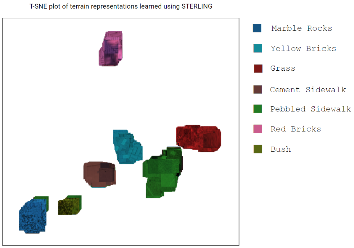
4.4.5.8 Visualizing the costmaps
Figure 4.15 shows cost visualizations of baseline approaches - rca (Yao et al., 2022), ser (Zürn et al., 2020), ganav (Guan et al., 2021) and Fully-Supervised in comparison with sterling. Figure 4.15 shows that rca and ser exhibit issues with visual artifacts due to homography transformations. ganav, trained on the rugd Wigness et al. (2019) dataset, fails to generalize to novel real-world situations. In contrast, costmaps from both the fully-supervised model and sterling efficiently guide planning, as demonstrated by quantitative results in Section 4.4.5 and results in behaviors that align with operator preferences, prioritizing sidewalks over terrains like rocks or bushes.
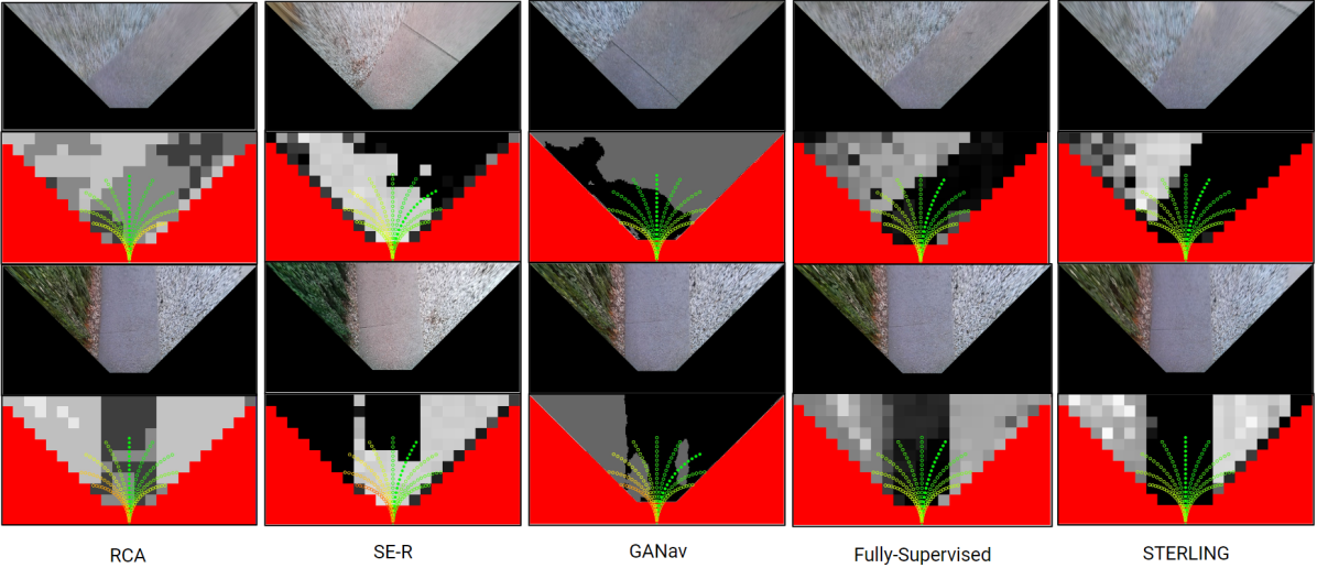
4.4.5.9 Generalization to Unseen Terrains
During autonomous off-road navigation, generalization to novel terrains is paramount. Although difficult to comment on generalizability, we document an instance during the large-scale deployment where sterling navigates around an unseen terrain “water puddle”, as shown in Figure 4.16.
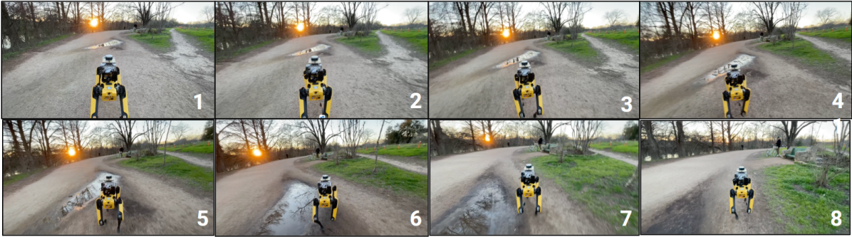
4.4.6 On the Efficacy of Multi-Modal Data Over Vision Alone
While it might seem that visual cues are sufficient for distinguishing terrains, as evidenced in Figure 4.7, the reality is more complex. Variations in lighting, shadow, color, texture, and other artifacts may lead to inconsistent representations for the same terrain type and can render visually distinctive terrains deceptively similar. For instance, while six different visual patches of the terrain “sidewalk” as shown in Figure 4.17 might each exhibit unique visual characteristics because of these variations, they all denote the same terrain category and evoke similar inertial-prioprio-tactile (ipt) response on the robot (feel similar to the robot). Solely relying on vision may lead to overlooking underlying commonalities between terrains, resulting in inconsistent terrain representations.
Another concrete example is the scenario of fallen leaves. A sidewalk, a grass patch, and a forest trail could all be covered with fallen leaves, making them visually similar. However, underneath those leaves, the actual terrain properties – and the robot’s interaction with them – vary significantly. While the leaves might visually mask the terrain differences, the robot would feel different terrain responses when moving over them due to differences in underlying ground properties.
Furthermore, visual similarity is not a conclusive indicator of identical terrains. Consider four images as a case in point, as shown in Figure 4.18. Though the first two and the last two images might seem visually similar, they represent distinct terrains: the first image depicts “bush”, the second and third denote “grass”, and the fourth is “sidewalk”. These three terrains induce different inertial, proprioceptive, and tactile responses in a robot. Thus, the mere semblance of appearance does not capture the relevant features of a terrain.
sterling’s approach of integrating additional modalities allows for more precise terrain identification by accounting for these subtleties. By considering variations and similarities among terrains across different modalities, we ensure relevant terrain representations for off-road navigation. In all examples shown in Figs. 4.17 and 4.18, sterling correctly associates the samples with the right cluster for each terrain.
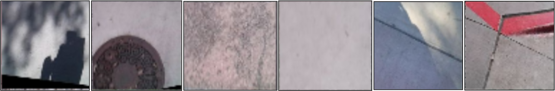
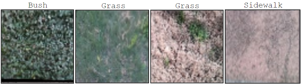
4.4.7 Limitations
In sterling, the data processing step assumes a flat-terrain geometry for all environments, which may not always be true in all conditions, such as stairs (Miki et al., 2022b) and boulders (Datar et al., 2023). Incorporating terrain geometry by utilizing depth observations to learn relevant terrain representations is a promising direction for future work. sterling also requires that the robot’s hardware is equipped with sensors such as inertial, proprioceptive, or tactile sensors to observe the terrains, in order to learn consistent terrain representations. Extending sterling by pretraining with large-scale off-road datasets using modern architectures such as transformers that are known to scale well with large-scale data (Kaplan et al., 2020) is an exciting direction for future work. sterling requires a mobile robot to physically traverse over diverse terrains in order to learn representations for preference-aligned navigation, which may be quite unsafe in certain situations. To address this concern, uncertainty-aware safe exploration and curiosity-based exploration focusing on informative and diverse terrains for data collection is a promising direction for future work.
In the sterling framework, there is an inherent requirement for a human operator to specify their preferences for all observed terrains. However, sterling does not account for situations where the robot encounters a visually novel terrain, leaving the operator’s preference for such terrains undetermined. Overcoming this limitation, in the upcoming section, I introduce a novel algorithm patern (Karnan et al., 2023c), which complements sterling in handling certain visually novel terrains. patern capitalizes on the understanding that, under specific conditions, non-visual observations of terrain can effectively be used to extrapolate operator preferences from known to visually novel terrains. This method thus extends the capabilities of terrain representation learning algorithms like sterling, enabling the extrapolation of known preferences to novel terrains.
4.5 Extrapolating Operator Preferences to Visually Novel Terrains
In this section, I introduce patern (Karnan et al., 2023c), a novel approach to extrapolate operator preferences in a self-supervised manner from known terrains to visually novel terrains. I first describe the data preprocessing, followed by the pre-adaptation training steps in Subsections 4.5.1 and 4.5.2, respectively. Section 4.5.3 then introduces the preference extrapolation training scheme. Finally, in Section 4.5.4 I describe the experiments performed to evaluate patern in comparison with relevant baseline algorithms.
4.5.1 Data Pre-Processing
In tandem with the visual patch extraction process used in the projection operator as in prior methods (Sikand et al., 2022; Karnan et al., 2023a), for every state , we also extract a 2-second history of time-series inertial (angular velocities along the x and y-axes and linear acceleration in the z-axis), proprioceptive (joint angles and velocities), and tactile (feet depth penetration estimates) data. To ensure the resulting input data representation for training is independent of the length and phase of the signals, we compute statistical measures of center and spread as well as the power spectral density, and maintain that as the input. All the visual patches extracted with the projection operator and the non-visual data for each state are then tagged with their corresponding terrain name, given that each trajectory uniquely contains a particular terrain type. In addition to processing the recorded data in the pre-adaptation phase, a human operator is queried for a full-order ranking of terrain preference labels.
4.5.2 Pre-Adaptation Training
We use a supervised contrastive learning formulation inspired by Sikand et al. (2022) to train the baseline functions and , represented as neural networks.
Training the Encoders: Given labeled visual patches and proprioception data, we generate triplets for contrastive learning such that for any anchor, the positive pair is chosen from the same label and the negative pair is sourced from another label. Given such triplets, we use triplet loss (Schroff et al., 2015) with a margin of to independently train the visual and proprioception encoders through mini-batch gradient descent using the AdamW optimizer. For the visual encoder, we use a 3-layer CNN of kernels, each followed by ReLU activations. This model, containing approximately 250k parameters, transforms size RGB image patches into an 8-dimensional vector representation . Similarly, our inertial encoder is comprised of a 3-layer MLP with ReLU activations, encompassing around 4k parameters, and maps proprioceptive inputs to an 8-dimensional vector . To mitigate the risk of overfitting, data is partitioned in a 75-25 split for training and validation, respectively.
Training the Utility Functions: In our setup, the utility function is represented as a two-layer MLP with ReLU non-linearity and output activation that maps an 8-dimensional vector into a singular non-negative real value. Given ranked operator preferences of the terrains, we follow Zucker et al. Zucker et al. (2011) and train the visual utility function using a margin-based ranking loss Vassileios Balntas and Mikolajczyk (2016). Furthermore, to ensure consistent predictions from and for both visual and non-visual observations at identical locations, we update parameters of using the loss . Here, denotes the stop-gradient operation, and and are the terrain representations from paired visual and non-visual data, respectively, at the same location.
The functions and prior to adaptation are collectively termed as , signifying their non-adapted state with respect to visually novel terrains. In our implementation, although we use supervised contrastive learning, in instances where explicit terrain labels might be absent, one can resort to self-supervised representation learning techniques, such as sterling (Karnan et al., 2023a), to derive and . patern can be applied regardless of the specific representation learning approach used.
4.5.3 Preference Extrapolation Training
During deployment, if the robot encounters a visually novel terrain, both visual and inertial-proprioceptive-tactile data is recorded to be used in the adaptation phase in patern, aiding in preference extrapolation and subsequent model adaptation. We refer to this collected data as the adaptation-set. We extract paired visual and non-visual observations at identical locations from the adaptation-set and use to extract proprioceptive representations . We cluster samples of and perform a nearest-neighbor search against existing terrain clusters from the pre-adaptation dataset that is within a threshold . We set this threshold to be the same as the triplet margin value of 1.0 which we find to work well in practice. This procedure seeks a known terrain that “feels” similar to the novel terrain which then inherits the preference of its closest match. Following this self-supervised preference extrapolation framework, the adaptation-set is aggregated with the pre-adaptation training set, and the visual encoder is retrained using the procedure described in Section 4.5.2. Additionally, the visual utility function is retrained with the extrapolated preference for the novel terrain. The updated functions and are collectively referred to as . Figure 4.19 illustrates retraining and preference extrapolation as described above.
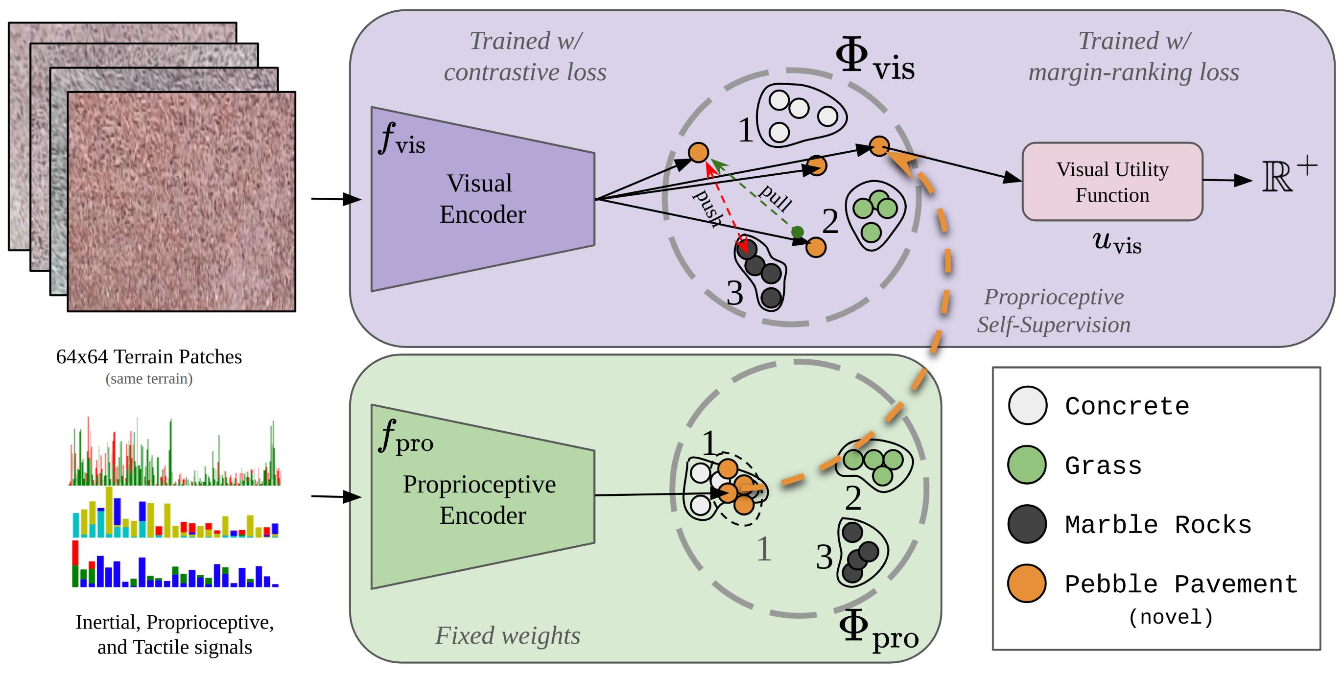
4.5.4 Experiments
In this section, I describe the physical robot experiments conducted to evaluate patern against other state-of-the-art visual off-road navigation algorithms. Specifically, our experiments are designed to explore the following questions:
-
()
Is patern capable of extrapolating operator preferences accurately to novel terrains?
-
()
How effectively does patern navigate under challenging lighting scenarios such as nighttime conditions?
-
()
How well does patern perform in large-scale real-world off-road conditions?
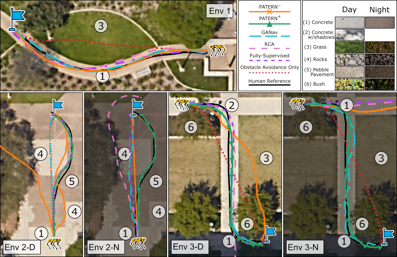
To study and , we execute a series of experiments consisting of short-scale outdoor navigation tasks. We then conduct a large-scale autonomous robot deployment along a 3-mile outdoor trail to qualitatively evaluate . We use the legged Boston Dynamics Spot robot for all experiments, equipped with a VectorNav VN100 IMU, front-facing Kinect RGB camera, Velodyne VLP-16 LiDAR for geometric obstacle detection, and a GeForce RTX 3060 mobile GPU. For local planning, we use an open-source sampling-based motion planner called graphnav (Biswas, 2013) and augment its sample evaluation function with the inferred preference cost . For real-time planning, we run and on the onboard GPU.
| Approach | Environment | ||||
| 1 | 2-D | 2-N | 3-D | 3-N | |
| Geometric-Only | 2.87 | 2.34 | 2.34 | 3.44 | 3.69 |
| rca(Yao et al., 2022) | 0.84 | 0.91 | 6.061 | 2.57 | 7.37 |
| ganav(Guan et al., 2021) | 1.47 | 2.98 | 3.07 | 0.898 | 1.42 |
| Fully-Supervised | 0.58 | 0.44 | 2.735 | 0.763 | 6.747 |
| 0.54 | 2.31 | 2.29 | 2.305 | 5.76 | |
| - | 0.56 | 1.097 | 0.86 | 0.763 | |
| Approach | Environment | ||||
| 1 | 2-D | 2-N | 3-D | 3-N | |
| Geometric-Only | 44.0% | 68.8% | 68.8% | 43.6% | 43.6% |
| rcarca | 100% | 97.3% | 67.4% | 100% | 99.4% |
| ganavGuan et al. (2021) | 93.9% | 71.6% | 71.4% | 100% | 100% |
| Fully-Supervised | 100% | 100% | 71.7% | 100% | 93.6% |
| 100% | 94.1% | 71.6% | 81.3% | 100% | |
| - | 100% | 98.2% | 100% | 100% | |
4.5.4.1 Data Collection
To collect labeled data for training , we manually teleoperated the robot across the UT Austin campus, gathering 8 distinct trajectories each across 3 terrains: concrete, grass, and marble rocks. Each trajectory, five minutes long, is exclusive to a single terrain type for ease of labeling and evaluation. The pre-adaptation training data was collected in the daytime under sunny conditions. Our evaluations then centered on two preference extrapolation scenarios: one, extending to new terrains such as pebble-pavement, concrete-with-shadows, and bushes, all experienced under varying daylight conditions ranging from bright sunlight to overcast skies, and two, adapting to nighttime illumination for familiar terrains that appear visually different. In our experiments, we use the preference order .
4.5.4.2 Quantitative Short-Scale Experiments
We evaluate patern in three environments with a variety of terrains within the UT Austin campus. We also test under two different lighting conditions, as shown in Figure 4.20. The primary task for evaluation is preference-aligned visual off-road navigation, in which the robot is tasked with reaching a goal, while adhering to operator preferences over terrains.
To evaluate the effectiveness of patern, we compare it against five state-of-the-art baseline and reference approaches: Geometric-Only (Biswas, 2013), a purely geometric obstacle-avoidant planner; RCA (Yao et al., 2022), a self-supervised traversability estimation algorithm based on ride-comfort; GANav, a semantic segmentation method 777https://github.com/rayguan97/GANav-offroad trained on RUGD dataset (Wigness et al., 2019); Fully-Supervised, an approach that utilizes a visual terrain cost function comprehensively learned using supervised costs drawn from operator preferences; and lastly, Human Reference, which offers a preference-aligned reference trajectory where the robot is teleoperated by a human expert. To train the rca and Fully-Supervised baselines, in addition to the entirety of the pre-adaptation dataset on the 3 known terrains, we additionally collect 8 trajectories each on the novel terrains during daytime.
In each environment, we perform five trials of each method to ensure consistency in our evaluation. For each trial, the robot is relocalized in the environment, and the same goal location is fed to the robot. In the environments where fails to navigate in a preference-aligned manner, we run five trials of the self-supervised instance that uses experience gathered in these environments to extrapolate preferences to the novel terrains or novel lighting conditions. Figure 4.20 shows the qualitative results of trajectories traced by each method in the outdoor experiments. Only one trajectory is shown for each method unless there is significant variation between trials. Table 4.3 shows quantitative results using the mean Hausdorff distance between a human reference trajectory and evaluation trajectories of each method. Table 4.4 shows quantitative results for the mean percentage of preference-aligned distance traversed in each trajectory. Note that both the reported metrics may be high if a method does not reach the goal but stays on operator-preferred terrain.
From the quantitative results, we see that, as expected, the approach is able to successfully navigate in an operator-preference-aligned manner in Environment 1, which did not contain any novel terrain types. However, fails to consistently reach the goal and/or navigate in alignment with operator preferences in the remaining environments. In the daytime experiments, Environment 2 contains a novel terrain (pebble pavement) absent from training data for , while Environment 3 contains both a novel terrain type (bush) and novel visual terrain appearances caused by tree shadows. In the nighttime experiments, all terrains contain novel visual appearances. Following deployments in Environments 2 and 3, patern extrapolates terrain preferences for new visual data using the corresponding proprioceptive data to retrain environment-specific instances. In each environment that the model fails, the self-supervised model is able to successfully navigate to the respective goal in a preference-aligned manner, without requiring any additional operator feedback during deployment, addressing and . While the fully-supervised baseline more closely resembles the human reference trajectory compared to during the day in Environments 2 and 3, unlike the fully-supervised approach, does not require operator preferences over all terrains and is capable of extrapolating to visually novel terrains.
4.5.4.3 Qualitative Large-Scale Experiment
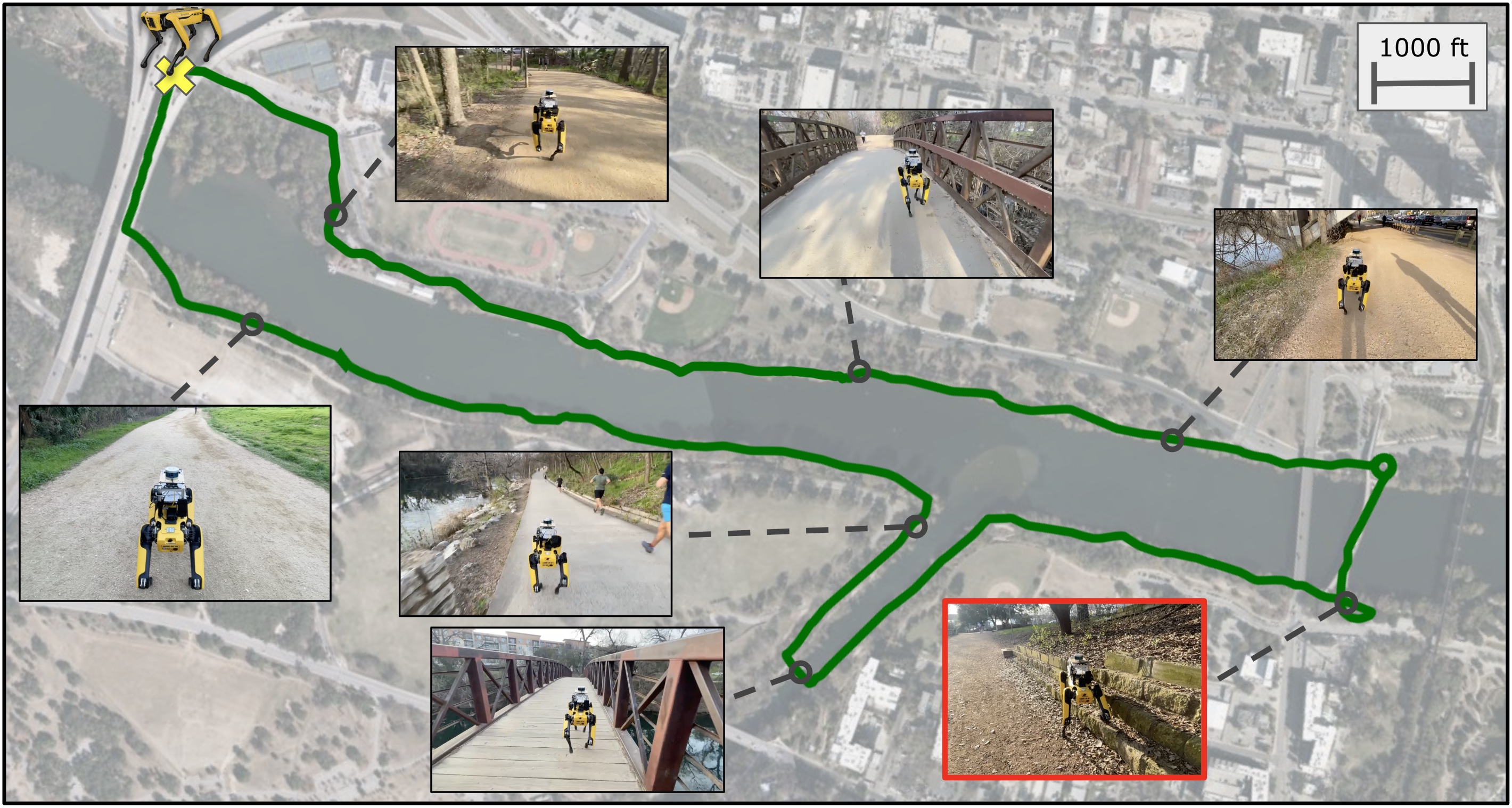
To investigate , we execute a large-scale autonomous deployment of patern along a challenging 3-mile off-road trail.888Ann and Roy Butler trail, Austin, TX, USA The robot’s objective is to navigate in a terrain-aware manner on the trail by preferring dirt, gravel and concrete over bush, mulch, and rocks. Failure to navigate in a preference-aligned manner may cause catastrophic effects such as falling into the river next to the trail. An operator is allowed to temporarily take manual control of the robot only to prevent such catastrophic effects, adjust the robot’s heading for forks in the trail, or yield to pedestrians and cyclists. The model used for short-scale experiments is augmented with approximately five minutes of combined additional data for dirt, bush, and mulch terrains commonly seen in the trail. Following this preference extrapolation, the model is able to successfully navigate the 3-mile trail, while only requiring one human intervention. Figure 4.21 shows the trajectory of the robot and a number of settings along the trail, including the single unexpected terrain-related intervention in the lower right corner, for the hour-long deployment. 999patern A video footage of the robot being deployed in the trail can be accessed here: https://youtu.be/j7159pE0u6s. This large-scale study addresses by qualitatively demonstrating the effectiveness of patern in scaling to real-world off-road conditions.
4.5.5 Limitations
patern is limited to robot configurations equipped with multi-modal sensing capabilities such as proprioception, depth, inertial, and tactile sensing alongside visual sensors. Additionally, patern uses similarities between novel and known terrains in its learned proprioception representation space to extrapolate preferences. Thus, patern needs to have had experiences with terrains bearing close inertial-proprioceptive-tactile resemblances for successful extrapolation. A noticeable limitation is that if a terrain evoking similar proprioceptive features has not been encountered before, patern might not be able to extrapolate preferences. To extrapolate preferences, patern requires a robot to physically drive over terrains, which may be unsafe or infeasible in certain cases. Extending patern with depth sensors to handle non-flat terrains is a promising direction for future work.
4.6 Summary
In this chapter, as outlined in Section 1.1, I introduce two novel algorithms that enable a mobile robot operating in off-road environments to align its navigation objectives with a human operator’s preference over terrain.
In the first contribution of this chapter, I introduced Self-supervised TErrain Representation LearnING (sterling) (Karnan et al., 2023a), a novel framework for learning terrain representations from easy-to-collect, unconstrained (e.g., non-expert), and unlabeled robot experience. sterling utilizes non-contrastive representation learning through viewpoint invariance and multi-modal correlation self-supervision objectives to learn relevant terrain representations for visual navigation. We show how features learned through sterling can be utilized to learn operator preferences over terrains and integrated within a planner for preference-aligned navigation. We evaluate sterling against state-of-the-art alternatives on the task of preference-aligned visual navigation on a Spot robot and find that sterling outperforms other methods and performs on par with a fully supervised baseline. We additionally perform a qualitative large-scale experiment by successfully hiking a 3-mile-long trail using sterling, demonstrating its robustness to off-road conditions in the real world.
In the second contribution of this chapter, I presented Preference extrApolation for Terrain-awarE Robot Navigation (patern) (Karnan et al., 2023d), a novel approach to extrapolate human preferences for novel terrains in visual off-road navigation. A limitation of sterling is that it requires human preference feedback for all observed terrains, which might be unable to acquire in certain conditions. patern extends sterling, addressing this limitation by learning an inertial-proprioceptive-tactile representation space to detect similarities between visually novel terrains and the set of known terrains. Through this self-supervision, patern successfully extrapolates operator preferences for visually novel terrain segments, without requiring additional human feedback. Through extensive physical robot experiments in challenging outdoor environments in varied lighting conditions, we find that patern successfully extrapolates preferences for visually novel terrains and is scalable to real-world off-road conditions.
Comparison with VOILA: The selection between voila, sterling, and patern depends on the nature of available human feedback and the suitability of online learning to the specific navigation task. voila is an online learning algorithm that learns a reactive navigation policy through reinforcement learning, imitating a video-only navigation demonstration in the same environment. In the case of the unavailability of such constrained video-only demonstrations, or lack of access to the demonstration environment necessary for online learning, voila’s applicability is limited. sterling, in contrast, is a self-supervised representation learning algorithm that learns relevant terrain representations from unconstrained robot experience. These representations allow offline querying of an operator’s terrain preferences, informing the development of a costmap that aligns off-road navigation with operator preferences. To enable such preference-aligned navigation, sterling requires access to an operator to query their relative terrain preferences for all observed terrains. patern complements sterling by enabling extrapolation of operator preferences from known to visually novel terrains, thereby reducing the requirement of consistent human feedback for certain terrains.
The three algorithms voila, sterling, and patern significantly advance the state-of-the-art in robot navigation in static indoor and outdoor environments, effectively addressing the value alignment problem. However, autonomous mobile robots deployed in the physical world frequently face dynamic scenarios, such as navigating around pedestrians, necessitating safe and socially compliant behavior in line with human preferences, as outlined by Francis et al. (2023). Towards enabling social compliance of robot navigation in the presence of humans, the forthcoming chapter introduces a comprehensive dataset named scand (Karnan et al., 2022a), consisting of demonstrations for socially compliant robot navigation. Additionally, it presents a novel hybrid algorithm designed to foster social compliance in autonomous mobile robots, combining the benefits of learning-based and heuristic-based navigation methods.
Chapter 5 Socially Compliant Robot Navigation
In this chapter, I introduce the third contribution of this dissertation, as outlined in Section 1.1, focused on the problem of socially compliant mobile robot navigation in the presence of dynamic agents such as humans. The contributions in this chapter consist of two parts. First, I introduce a large-scale dataset of demonstrations for socially compliant robot navigation behaviors called scand (Karnan et al., 2022a). We show that navigation policies learned through imitation learning using scand are perceived to be safer and more socially compliant than a classical navigation stack. Second, I introduce a hybrid algorithm for socially compliant robot navigation (Raj et al., 2023), combining the benefits of a learning-based and a classical navigation algorithm. The chapter is organized as follows. Section 5.1 provides an introduction to the problem addressed in this chapter. Section 5.2 reviews relevant related work in datasets and algorithms for socially compliant robot navigation, followed by Sections 5.3, 5.4, and 5.5 that introduce the dataset and algorithmic contributions of this chapter, respectively.
5.1 Introduction
In this section, I introduce the concept of socially compliant robot navigation and the need for a dataset of human-teleoperated demonstrations for socially compliant robot navigation. Additionally, I introduce limitations with using either a classical or learning-based navigation stack for enabling socially compliant navigation and highlight our contribution consisting of a hybrid approach combining classical and learning-based navigation policies for mobile robot navigation.
Social navigation is the capability of an autonomous agent to navigate in a socially compliant manner such that it recognizes and reacts to the objectives of other navigating agents, at least somewhat adjusting its own path in response, while also projecting signals that can help the other agents reciprocate. Enabling mobile robots to navigate in a socially compliant manner has been a subject of great interest recently in the robotics and learning communities (Helbing and Molnár, 1995; Xiao et al., 2020b; Chen et al., 2018; Everett et al., 2021; Mirsky et al., 2021). Towards enabling this capability, demonstration data of socially compliant navigation for mobile robots, such as the ones shown in Figure 5.1, can be a valuable resource. For instance, such demonstration information can be used to learn socially compliant robot navigation using the paradigm of Learning from Demonstrations (lfd) (Schaal, 1996; Argall et al., 2009) or understanding human navigation in the presence of autonomous robots (Martin-Martin et al., 2021).
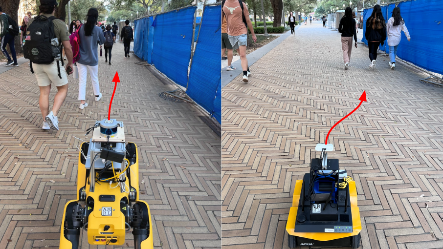
Datasets for social navigation, generally used for learning and benchmarking, include data collected both in the real world (Rudenko et al., 2020) and in simulated environments (Tsoi et al., 2020; Manso et al., 2020). While such datasets provide basic trajectories of the robots and humans, they either contain limited interactions in constrained, orchestrated environments or restrict themselves to indoor-only navigation scenarios. When collecting data in such controlled settings (Rudenko et al., 2020), naturally occurring social interactions including—but not limited to—following lane rules of a country, yielding to pedestrians and vehicles, walking with and against a crowd of people, and street crossing are not captured. Additionally, the robots used for data collection in previous social navigation datasets (Rudenko et al., 2020) tend to use a simple controller for point-to-point navigation that does not explicitly exhibit socially aware navigation.
Recently, imitation learning has emerged as a useful paradigm for designing mobile robot navigation controllers (Pan et al., 2018; Karnan et al., 2021; Bojarski et al., 2016; Lecun et al., 2005). In this paradigm, the desired navigation behavior is first demonstrated by an agent such as a human, the recording of which is then utilized by an imitation learning algorithm to imitate. This intuitive way of teaching a task to a robot is also easy for non-expert humans since it only requires providing demonstrations, instead of defining the rules of the task itself, which may be hard to explicitly define for social navigation. Motivated by recent successes of imitation learning in robot navigation, we posit that one way to enable autonomous agents to navigate socially is through learning from human demonstrations of socially compliant navigation behavior. However, there is a lack of large-scale datasets containing socially compliant navigation demonstrations in the wild that can be utilized for imitation learning.
To fill this gap, in Section 5.3, I introduce a dataset of demonstrations for socially compliant robot navigation in the wild. Our dataset contains 8.7 hours of human-teleoperated, socially compliant, navigation demonstrations, specifically, Velodyne lidar scans, joystick commands, odometry, camera visuals, and 6D inertial (IMU) information collected on two morphologically different mobile robots—a Clearpath Jackal and a Boston Dynamics Spot—within the University of Texas at Austin university campus. Comprising 25 miles in total over 138 trajectories, Socially CompliAnt Navigation Dataset (scand) (Karnan et al., 2022a) is publicly released111www.cs.utexas.edu/xiao/SCAND/SCAND.html and also contains labeled tags of naturally occurring social interactions with every trajectory. We demonstrate the utility of the dataset for studying questions relevant to social navigation. We show that a navigation policy learned using imitation learning on the scand dataset leads to policies that are perceived by human participants to be more socially compliant and safe than the ROS move_base navigation stack.
As the second contribution of this chapter, in Section 5.5, I leverage the insight that although a mobile robot can learn simple social navigation behaviors end-to-end as shown in Section 5.4.1, the majority of navigation scenarios encountered by a mobile robot do not require such a specialized end-to-end learned policy. Additionally, without the safety guarantees present in classical navigation stacks, such a policy may not be reliable to use in all scenarios. Our analysis on scand reveals that classical navigation systems adequately cater to a significant proportion—up to 80%—of social navigation scenarios in the scand dataset (Figure 5.2 left), underscoring the importance of classical navigation systems in routine social situations. To address the limitations identified, the second key contribution of this chapter proposes a novel hybrid approach. This method alternates between a classical geometric planner and a data-driven planner, effectively balancing the strengths of both through a data-driven approach. Our comparative analysis demonstrates that this hybrid model surpasses both classical and learning-based methods when evaluated independently, especially in terms of social compliance across diverse metrics. In addition to evaluations on the scand dataset, we also perform a practical human study involving two robots operating in distinct campus environments (Figure 5.2 left).
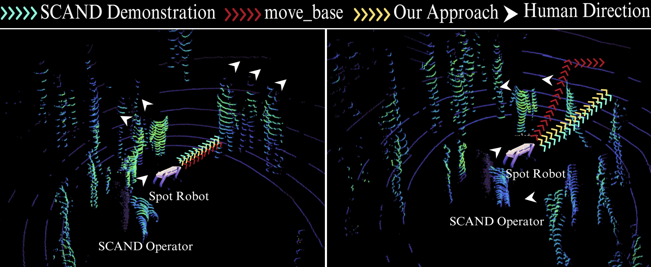
5.2 Related Work
In this section, I review related literature on classical and learning-based approaches for social navigation. I additionally survey relevant datasets for robot navigation and contrast their contributions with this work. For a more general overview of related approaches to social navigation, refer to Section 2.3.
5.2.1 Classical Methods for Social Navigation
For several decades, roboticists have been developing an array of classical navigation systems to facilitate collision-free robot movement from one location to another. These systems typically employ a global planner, such as A* (Hart et al., 1968a) or D*(Ferguson and Stentz, 2006), to outline a high-level path, augmented by a local planner(Fox et al., 1997b; Quinlan and Khatib, 1993) for generating detailed motion commands. This combination ensures adherence to the global route while navigating around obstacles. Classical navigation systems generally necessitate a pre-defined cost function (Lu et al., 2014), balancing various factors like path length, obstacle clearance, energy efficiency, and increasingly, social compliance. To execute these functions, methodologies such as sampling-based (Kavraki et al., 1996; Kuffner and LaValle, 2000; Fox et al., 1997b), optimization-based (Ratliff et al., 2009; Quinlan and Khatib, 1993), or potential-field-based (Koren et al., 1991) techniques are utilized for motion command generation. These approaches are valued for their safety, explainability, and testability attributes, which are either provably or empirically optimal. Such qualities are crucial for real-world applications of physical robots, especially in human-centric environments, thus maintaining the popularity of classical navigation systems in the robotics industry (Ama, ; Starship, 2022; Dilligent Robotics, 2022; Tiny Mile, 2022). However, adapting these classical approaches to socially complex environments often involves significant engineering efforts, including the manual design of cost functions (Lu et al., 2014) and the fine-tuning of navigation parameters (Zheng, 2021). These challenges have spurred interest in exploring learning-based methodologies for improving the social compliance of autonomous mobile robots.
5.2.2 Machine Learning for Social Robot Navigation
Recently, several algorithms have emerged that show the potential of applying machine learning to address challenges in social robot navigation (Xiao et al., 2020b; Mirsky et al., 2021; Francis et al., 2023). Broadly speaking, in the robot navigation literature, learning-based approaches have been shown to be successful in problems such as adaptive planner parameter learning (Xiao et al., 2021), overcoming viewpoint invariance in demonstrations (Karnan et al., 2021), and end-to-end learning for autonomous driving (Bojarski et al., 2016; Pfeiffer et al., 2018; Wang et al., 2021b). Specifically in applying imitation learning for social navigation, the work by Tai et al. (2018) is the closest to our work. They provide a simulation framework in gazebo (Koenig and Howard, 2004) along with a dataset generated using the same where virtual human agents navigate following the social force model (Helbing and Molnár, 1995). They additionally train a social navigation policy using the Generative Adversarial Imitation Learning algorithm assuming the social force model as the “expert” demonstrator and show a successful deployment of the learned policy in the real world on a TurtleBot (Lee, 2013). While their work has shown that imitation learning can be applied to address the social navigation problem, they do so assuming the social force model in simulation as the “expert” demonstration. While simulated environments enable fast and safe data collection for online learning, they lack the naturally occurring social interactions seen in the wild. Also, as I show in Section 5.4.2, there can be more than one strategy for an agent to navigate socially in a scene, which is not considered in their work.
Other learning paradigms such as Reinforcement Learning (rl) have also been applied to address the social navigation problem. Everett et al. (2021) present ca-drl, a multi-agent collision avoidance algorithm learned using rl. While this work shows impressive real-world results, their approach is limited to specific social scenarios and requires simulating these scenarios for the online learning algorithm to learn episodically. Kretzschmar et al. (2016) use Inverse Reinforcement Learning to learn cost functions for a socially compliant navigation policy. Similar to our work, they utilize human demonstrations of the social navigation task, however, they do so utilizing a small-scale, one-hour-long dataset. In this work, we contribute a large-scale dataset of robot social navigation demonstrations comprising multi-modal real-world data over multiple hours, both indoors and outdoors, on two different robots. Additionally, we train an imitation learning algorithm to show it is possible to learn socially compliant global and local navigation policies using our dataset.
5.2.3 Datasets for Social Navigation
Over the last decade, datasets containing robots navigating in both simulated and real-world environments have been useful for a wide variety of research areas, such as tracking groups of people (Rudenko et al., 2020; Lau et al., 2009; Linder et al., 2016), human trajectory prediction (Chung and Huang, 2012), navigation (Hirose et al., 2019), robot localization (Biswas and Veloso, 2013; Geiger et al., 2013) and collision risk assessment (Lo et al., 2019).
Simulated Datasets for Social Navigation: Social environments in simulation can provide researchers with fast data collection on social navigation (Tsoi et al., 2020, 2021; Holtz and Biswas, 2021; Tai et al., 2018). Moreover, such simulated environments can be generated with a specified number of elements: the number and locations of the humans, the structure of the room, the number of objects, and the interactions between people and between objects and people (Manso et al., 2020). While simulated platforms provide these benefits, they are limited in that they lack the natural, real-world interactions that are experienced by humans. Datasets that capture real-world robot navigation data in the wild provide researchers with more naturally occurring scenarios (Biswas and Veloso, 2013; Yan et al., 2020, 2017; Carlevaris-Bianco et al., ). Additionally, datasets collected in the wild provide sensory data for these scenarios which can be then used for perceptual tasks related to navigation (de Vicente, 2021).
Real-world Datasets for Robot Navigation: In addition to simulated datasets, several real-world datasets for long-term robot navigation in human environments have also been made available over the last decade. In the CoBots dataset (Biswas and Veloso, 2013), two CoBots were deployed indoors autonomously using a topological graph planner and collected more than 130 km worth of laser scans, odometry, and localization data over 1082 deployments. Similarly, the L-CAS (Yan et al., 2017), FLOBOT (Yan et al., 2020), JRDB (Martin-Martin et al., 2021) and NCLT (Carlevaris-Bianco et al., ) datasets contain LiDAR scans, RGBD visuals, GPS, and IMU data collected independently on different robots, addressing perception-related challenges to long-term robot navigation. In all these different datasets, the robots were deployed in a public environment, such as a restaurant or a university campus, and teleoperated by a human as opposed to being autonomous, but these teleoperated demonstrations are not explicitly socially compliant. The JRDB social navigation dataset by Martin-Martin et al. (2021) is the closest to our work, but it is smaller in scale, containing only 64 minutes worth of data from 54 indoor and outdoor trajectories. While the focus of the JRDB dataset is to solve perception-related challenges such as human tracking and detection in social navigation, the focus of the scand dataset in this work is to address the “navigation” sub-component of social navigation. The THÖR dataset by Rudenko et al. (2020) provides motion trajectories of both robots and humans using tracking helmets. However, this is smaller in scale since it contains only one hour’s worth of data. Also, the data is collected indoors in an 8.4x18.8m laboratory room with an orchestrated social navigation scenario for the human agents in the scene and a socially unaware, pre-defined path for the robot—adjusting neither its speed nor trajectory to account for surrounding people. Existing real-world datasets for robot navigation are summarized in Table 5.1.
While previous datasets collected with robots and humans have proven to be useful to study localization, perception, and other navigation-related challenges, they lack demonstration information in the form of motion commands and navigation strategies in different social scenarios that could help us understand socially compliant robot navigation in the presence of other autonomous agents. The scand dataset introduced in this work addresses this gap and provides rich human demonstration information in the form of joystick commands and multi-modal robot sensor data in different, naturally occurring social scenarios. scand also contains labeled tags of twelve different types of social interactions, as described in Table 5.2, that occurred along the paths. Also, since robots of different morphologies and capabilities could navigate differently and induce different social interactions, scand also includes data from two different robots. For example, the legged Spot, capable of climbing stairs could choose to prefer the stairs along its path while navigating whereas the wheeled Jackal might choose a ramp to navigate. The other datasets use only one robot to collect data (the Cobots dataset from Biswas and Veloso (2013) uses two robots but they are morphologically the same). Using two morphologically different robots makes scand useful to investigate social navigation in robots with different morphologies (wheeled vs. legged).
| Dataset | # Traj. | Dist. (Km) | Dur. (min) | Sensors | Nav. method | # Robots | Location |
| CoBot Biswas and Veloso (2013) | 1082 | 131 | 15600 | 2D Range Scanner, RGB-D Camera, Wheel Odometry | Autonomous | 2 | Indoors + Outdoors |
| L-CAS Yan et al. (2017) | 3 | N/A | 49 | 3D LiDAR | Teleoperated | 1 | Indoors |
| NCLT Carlevaris-Bianco et al. | 27 | 147.4 | 2094 | 3D LiDAR, RGB Camera, IMU, Wheel Odometry, GPS | Teleoperated | 1 | Indoors + Outdoors |
| FLOBOT Yan et al. (2020) | 6 | N/A | 27.5 | 3D LiDAR, RGB-D camera, Stereo Camera, 2D LiDAR, OEM incremental measuring wheel encoder, IMU | Autonomous | 1 | Indoors |
| JRDB Martin-Martin et al. (2021) | 54 | N/A | 64 | 3D LiDAR, 2D LiDAR, Omnidirectional Stereo Suite, RGB camera, RGB-D stereo camera, 6D IMU | Teleoperated | 1 | Indoors + Outdoors |
| THÖR Rudenko et al. (2020) | 600 | N/A | 60 | 3D LiDAR, Motion capture system, Eye-tracking Glasses | Autonomous | 1 | Indoors |
| SCAND | 138 | 40 | 522 | 3D LiDAR, RGB-D Camera, Monocular Camera, Stereo Camera, Wheel Odometry, Visual Odometry | Teleoperated | 2 | Indoors + Outdoors |
5.3 Data Collection Procedure
In this section, I outline the data collection procedure used in scand and describe the sensor suite present on both robots. I then describe the labeled annotations of social interactions provided with every trajectory.222The research described in this section was done in collaboration with Anirudh Nair, Xuesu Xiao, Garrett Warnell, Alexander Toshev, Soeren Pirk, Justin Hart, Joydeep Biswas, and Peter Stone.
5.3.1 Collecting Data
To collect multi-modal, socially compliant demonstration data for robot navigation, four human demonstrators navigate the robot by teleoperation using a joystick. We collected data within the UT Austin University campus, with the demographics of the humans in the scene comprised mostly of students, faculty, and other campus denizens. For each of the 138 trajectories in scand, the human demonstrator walks behind the robot at all times, maintaining on average a distance of 2 meters. The human demonstrator does not explicitly interact with the crowd in the scene. Unlike other datasets for social navigation (Rudenko et al., 2020), we do not restrict data collection to a controlled, indoor environment or orchestrate a social scenario for data collection. Instead, similar to the JRDB dataset (Martin-Martin et al., 2021), we perform data collection in the wild in both indoor and outdoor environments. The two robots are driven around the university campus on frequently used sidewalks, roads, and lawns, and inside buildings, all with people on the scene during peak hours of high foot traffic. Data collection extends to outdoor areas adjacent to the university’s football stadium on game days, capturing diverse interactions with dense, public crowds near the venue. The Spot is driven at linear and angular velocities in the range of and , respectively, and the Jackal is driven in the range of and , respectively. Note that these velocities are within the range of many people’s normal walking speed.
Figure 5.4 shows the sensors present on the Clearpath Jackal and the Boston Dynamics Spot robots. Both robots have in common a VLP-16 Velodyne laser puck publishing at a frequency of 10 Hz, a 6D inertial (IMU) sensor at 16 Hz, and a front-facing Azure Kinect RGB camera at 20 Hz. In addition to these common sensors, the Jackal has a front-facing stereo camera (20 Hz) and wheel odometry (30 Hz), while the Spot has five monocular cameras on its body (publishing at 5 Hz), placed as shown in Figure 5.4. We utilize the Boston Dynamics APK to record the visual odometry of its body frame and the joint angles of the legs on the robot. scand also contains transforms between the frames of each of the sensors relative to the robot’s body for both robots. We utilize AMRL’s software stack (Biswas, 2013) for data collection from different sensors which we record in the rosbag format (Robotic Operating System, ).
Although we provide visual information of the scene in the form of surround-view monocular images on the Spot, RGB images from the front-facing Kinect camera, and 3D Velodyne laser scans on both robots, since the focus of this work is specifically on navigation, we do not provide any labeled annotations for human detection or tracking. We refer the reader to the JRDB dataset (Martin-Martin et al., 2021) which contains detailed, high-quality annotations for solving perception-related tasks. Instead, scand contains joystick commands of linear and angular velocities executed by the demonstrator while teleoperating the robot socially, along with rich, multi-modal sensory information of the environment including labeled annotations of 12 different social interactions in every trajectory. Figure 5.3 shows five example scenarios and their associated tags.
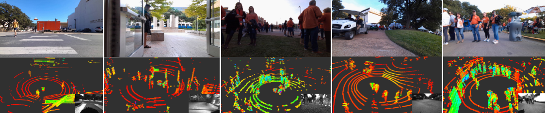
| Tag | Description | # Tags |
| Against Traffic | Navigating against oncoming traffic | 22 |
| With Traffic | Navigating with oncoming traffic | 74 |
| Street Crossing | Crossing across a street | 34 |
| Overtaking | Overtaking a person or groups of people | 14 |
| Sidewalk | Navigating on a sidewalk | 57 |
| Passing Conversational Groups | Navigating past a group of 2 or more people that are talking amongst themselves | 38 |
| Blind Corner | Navigating past a corner where the robot cannot see the other side | 6 |
| Narrow Doorway | Navigating through a doorway where the robot waits for a human to open the door | 15 |
| Crossing Stationary Queue | Walking across a line of people | 6 |
| Stairs | Walking up and/or down stairs | 22 |
| Vehicle Interaction | Navigating around a vehicle | 21 |
| Navigating Through Large Crowds | Navigating among large unstructured crowds | 27 |
5.3.2 Labeled Annotations of Social Interactions
We manually annotate each trajectory in scand with labels describing social interactions that occurred along the path. The labels are in the form of a list of textual captions of social interactions taking place in a trajectory, chosen from a set of twelve predefined labels of social interactions observed in scand. For the full list of labels, refer to Table 5.2. We intend the labels to be useful for future studies of specific scenarios that occur during social navigation in the real world.
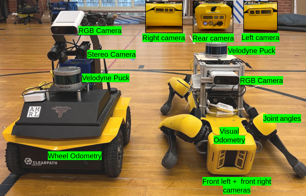
5.4 SCAND Dataset Analysis
In this section, I present several analyses utilizing scand to explore socially compliant robot navigation. First, to analyze the applicability of tools from imitation learning to learn socially compliant navigation policies, in Section 5.4.1, we explore behavior cloning navigation policies using scand. Second, in Section 5.4.2, we evaluate if there is more than one way to navigate in a socially compliant manner. This evaluation is performed by learning a neural network-based classifier trained for the task of demonstrator classification, given a ten-second sequence of sensor observations and joystick commands as input. Finally, in Section 5.4.3, we perform a case study on scand by analyzing existing classical navigation approaches to understand the social compliance they offer, in comparison to the human demonstrations present in scand. The insights from the analysis performed in this section are utilized in Section 5.5 to develop a novel hybrid approach to social robot navigation.
5.4.1 Imitation Learning for Global and Local Planning
In this section, using scand, we explore the question “Can we learn a local and global planner for social navigation using behavior cloning on scand?”. We hypothesize that the answer is yes, and through physical human-robot experiments in an indoor lab environment observe that the policy learned using scand leads to safe and socially compliant navigation behaviors.
Approach and Implementation: We apply the bc imitation learning algorithm (Bain and Sammut, 1995) on scand to jointly train end-to-end a socially-aware global and local planner for robot navigation. The objective of the global planner agent is to predict the socially compliant global plan (the future trajectory driven by the human demonstrator, within a horizon of ten meters distance from the robot). The local planner agent’s objective is to predict the forward and the angular velocities demonstrated in scand in a socially compliant manner. We jointly train the local and the global planner agents using a common representation space of observations, as shown in Figure 5.5. However, unlike the demonstrator classifier network with a single classifier head, here we use two different heads (three-layer fully connected networks) for the global and the local planner agents. As inputs to the bc agent, we provide processed sensor observations from scand of two seconds in length to account for temporal variations in the scene; this includes BEV lidar scans (subsampled to 2 Hz and represented as grayscale BEV image as shown in Figure 5.5), positions of the previous lidar frames relative to the first lidar frame and inertial information at each of the lidar frames. Additionally, we also provide the global path and desired velocities produced by move_base (ROS-Planning, 2022) using the location of the robot ten meters in the future from its current position as prior information to the network. We posit that feeding this prior information from move_base as inputs to the bc agent would enable improved performance. The global planner head predicts 200 points in the path driven by the demonstrator, and the local planner predicts 20 timesteps of joystick commands (, ) issued by the demonstrator since the current frame. We sum the mean-squared error loss objectives for both agents and update their parameters together. Note that we do not utilize any representation learning algorithm to pretrain the encoders that process the sensor observations, but doing so may potentially improve results. However, since the focus of this analysis is to show the potential of scand in enabling existing imitation learning algorithms to learn socially compliant navigation policies, representation learning is left to future work.
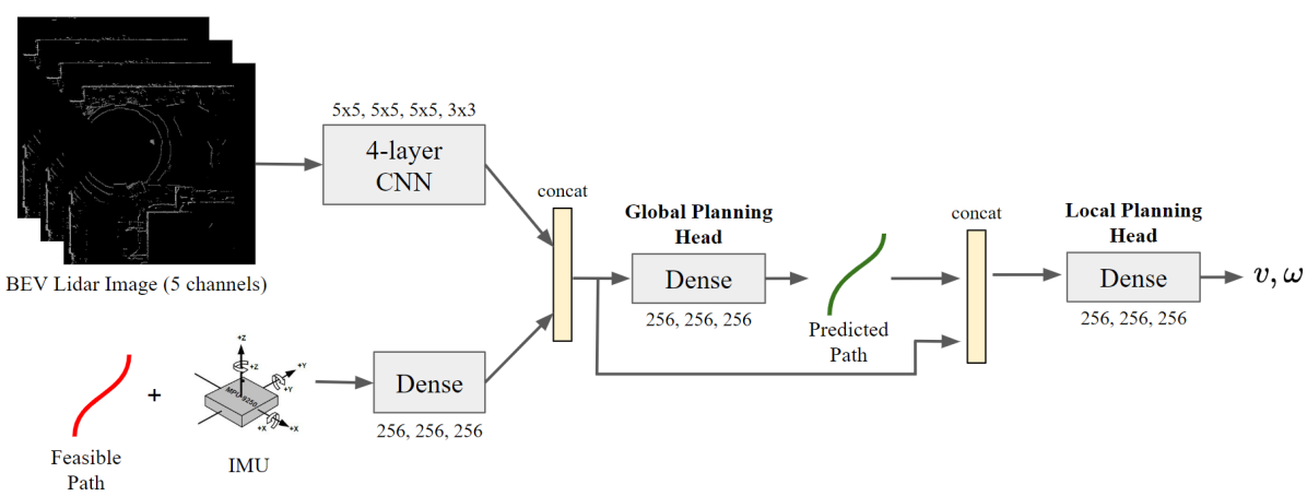
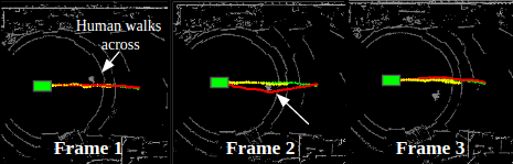
Results and Conclusion: To evaluate the social navigation behavior of the global planner, we compute the Hausdorff distance metric on a held-out test set, between the global path predicted by the learned global planner agent and the actual path driven by the demonstrator in the future. The average Hausdorff distance between the move_base global path and the demonstrated path in a held-out test set is 1.25. However, after training the bc global planner agent on scand, the average Hausdorff distance between the predicted trajectory and the demonstrated trajectory is improved at 0.26. Figure 5.6 shows a scenario involving the robot, and a human walking across the robot’s path. We see that in this scenario, the predicted path closely matches that of the socially compliant demonstrated path, whereas move_base turns in the direction of the human’s future state, creating an undesired interaction.
To validate the learned local planner agent, we conduct real-world experiments using the Spot robot with fourteen human participants in an indoor location. We design two scenarios—static and dynamic—to evaluate the social compliance and safety of the learned local planner and the move_base planner, as shown in Figure 5.7. In the static scenario, the robot starts five meters ahead of a stationary human in the robot’s path, and tries to navigate to a goal position five meters behind the human. In the dynamic scenario, the robot and the human start facing each other 10 meters apart and try to reach the start position of the other. In the dynamic scenario, the participants were asked to navigate in a socially compliant manner to their goal position and in both scenarios, the participants were asked to observe the navigation behavior of the robot. After each scenario, for both the algorithms, a questionnaire was presented to the participant with the two following questions:
-
1.
On a scale of 1 to 5, how “socially compliant” do you think the robot was? (think of social compliance as how considerate the robot was of your presence)
-
2.
On a scale of 1 to 5, how “safe” did you feel around the robot?
We randomized the order in which the two algorithms (move_base and bc policy) were played to the participants. Figure 5.8 shows the responses of the human participants. On average, more humans felt the imitation learning agent trained on scand was more socially compliant (scand mean=, sd=; move_base mean=, sd=) and safer (scand mean=, sd=; move_base mean=, sd=) than the move_base agent. Results for both questions demonstrate statistical significance, as determined by a One-Way Analysis of Variance (ANOVA) (Safe ; Socially Compliant ), aligning with expectations given that the move_base agent was not designed for social compliance. Refer to the online video333https://youtu.be/QgBfMjWpQIw for scenarios showing the behavior of both the algorithms in the static and dynamic trials. The results of this study support our hypothesis that imitation learning using demonstrations provided in scand produces socially compliant navigation policies. To facilitate reproducibility, we have made available the train-test splits of the trajectories collected with the Spot robot in a 75%-25% ratio, respectively. These splits, along with the complete dataset, are accessible on Dataverse444https://dataverse.tdl.org/dataset.xhtml?persistentId=doi:10.18738/T8/0PRYRH.
Limitations: In this section, I demonstrate that behavior cloning a reactive navigation policy using scand by optimizing the mean-squared error loss objective produces socially compliant and safe navigation behaviors on the robot. Nevertheless, this approach has its constraints. It predicts only a single instance of navigation behavior in a reactive way for each scene, based on the presumption of an unimodal behavior distribution, when in fact, as I show in the following Section 5.4.2, there can be more than one way to navigate in a socially compliant manner. To extend the capabilities of the imitative navigation policy to handle complex social navigation scenarios that may be multi-modal, alternate approaches that are specifically designed to capture the inherent multi-modality in demonstrations, such as Gaussian Mixture Models (Jaquier et al., 2020), Inverse Reinforcement Learning (Abbeel and Ng, 2004; Wulfmeier et al., 2015), or Diffusion Policies (Chi et al., 2023) are necessary. Towards this end, I present directions for short-term future work, summarized in Section 6.2.1.3.
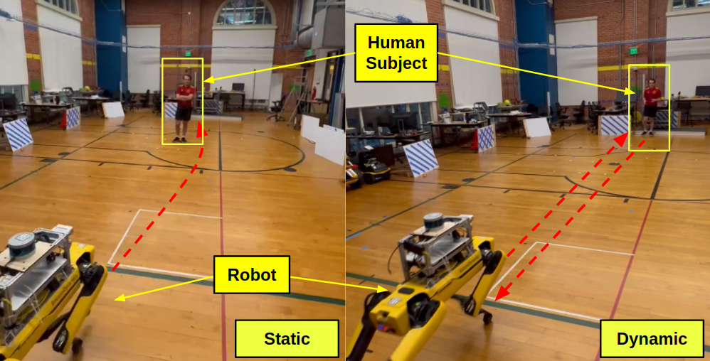
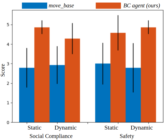
5.4.2 Demonstrator Classification
In this section, I present an analysis performed using scand to evaluate if there is more than one way to navigate in a socially compliant manner. By training a neural-network-based classifier on the task of demonstrator classification, we find that there may be more than one strategy to navigate in a socially compliant manner in a given scenario.
Approach and Implementation: To analyze if there is more than one way to navigate in a socially compliant manner, we choose sixteen trajectories driven by two demonstrators navigating along the same route (Speedway road within the university campus) and train a neural network for the task of demonstrator classification (training on twelve trajectories and validating on four trajectories). The input to our classifier is a ten-second-long sequence of sensor observations. This sequence consists of processed sensor observations provided in scand such as lidar scans (subsampled to 1 Hz and represented as grayscale bird’s eye view (BEV) image), positions of the robot relative to the first lidar frame, future trajectory driven by the human consisting of 200 points in the most recent lidar frame, inertial and joystick values executed by the demonstrator at each of the lidar frames. The neural network architecture consists of a four-layer convolutional encoder to process the grayscale BEV lidar images and a three-layer fully connected network to process the other sensor observations. The representations output by these layers is fed into a three-layer fully connected network classifier head. We use the binary cross-entropy loss to train the classifier network. Figure 5.9 shows the demonstrator classifier’s inputs and neural network architecture.
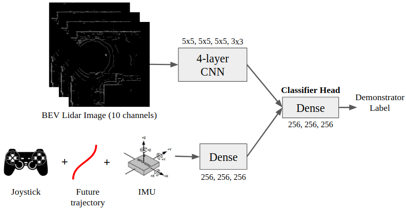
Results and Conclusion We find that the classifier is about 74% accurate at classifying the expert on the held-out test set. Given that random guessing would lead to a success rate of 50%, and that many ten-second trajectories do not indicate any differentiating social interactions, this number is indicative of successful prediction. The ability of the classifier to identify the demonstrator from their navigation style with an accuracy of 74.48% using a ten-second sequence of observations, combined with the fact that the demonstrations in scand are socially compliant shows that there exists more than one strategy for socially compliant navigation in a given scenario. Enabling algorithms to take into consideration this manifold of socially compliant robot navigation behaviors naturally observed in human demonstrations is a promising direction for future work.
5.4.3 Analyzing Social Compliance of Classical Navigation Algorithms
In this section, I present an analysis of the social compliance of classical heuristic-based navigation algorithms on the scenarios in scand. The findings demonstrate that classical navigation systems can safely and efficiently produce socially compliant navigation behaviors in a substantial proportion (up to 80%) of navigation scenarios in scand. The insights gleaned from this evaluation, coupled with earlier analyses from Sections 5.4.1 and 5.4.2 on scand informs the development of an innovative hybrid approach that integrates classical and learning-based techniques for improving socially compliant robot navigation, as detailed in Section 5.5.
5.4.3.1 Defining Social Compliance on SCAND
During social robot navigation in scand, at each time step , we denote a navigation scenario as observed by the onboard robot perception, which includes a sequence of 3D LiDAR scans , RGB-D images , odometry , and IMU readings , and a navigation goal , i.e., , where denotes the history length included in the scenario at and denotes that the data is from the scand demonstrations.
We further define the navigation behavior at as , which can take the form of either a global or local plan ( or ). A demonstrated global plan in scand, computed as the human-driven trajectory starting from time , takes the form of a sequence of waypoints . A demonstrated local plan is represented as a sequence of joystick action commands , where and is the linear and angular velocity respectively. and denote the length of the navigation behavior on the global and local plan level.
Producing the navigation behavior (i.e., or ) based on as input, a navigation system is defined as a function (i.e., or on the global or local level): . We use the difference between and , i.e., , to quantify the social compliance of the navigation system on the demonstrated navigation scenarios in scand. In particular, we use the Hausdorff distance between and and L2-norm between and to evaluate global and local planning systems respectively.
Given different social scenarios , a socially compliant navigation planner is expected to generate navigation behaviors that are similar to the expert demonstration in scand. In the context of this case study, we assume that the expert demonstrations in scand is the “ground truth” socially compliant behavior when facing . However, this assumption is not without its limitations, as highlighted in Section 5.4.2. It is acknowledged that there may be more than one way to navigate in a socially compliant manner in any given scenario. This variability prompts the execution of a human study to evaluate the social compliance of navigation strategies, irrespective of their alignment with scand demonstrations (referenced in Section 5.5.4). Under this premise, we define social compliance as follows.
Definition 1. In a given navigation scenario, denoted as , a navigation behavior is classified as socially compliant when the deviation is less than a predefined small threshold .
Further, let be the fraction of the total scand time steps , in which is socially compliant. We will use to indicate how socially compliant a navigation system is.
5.4.3.2 Classical Navigation Systems
We study four classical navigation systems, each with accessible open-source implementations, on the scand social navigation scenarios and compare their navigation behavior against the scand demonstrations .
1.move_base: The Robot Operating System (ros) move_base (ROS-Planning, 2022) global planner utilizes a static costmap representation of the environment and Dijkstra’s algorithm to generate an optimal path from the robot’s current pose to the goal. The resulting path is smoothed and interpolated so that the local planner can follow. The move_base default local planner, the Dynamic Window Approach (dwa) by Fox et al. (1997b), operates reactively, considering the robot state, sensor information, kinematic constraints, and global path. It generates real-time linear and angular velocity commands by evaluating various trajectories within the robot’s dynamic window, ensuring progress toward the goal while avoiding obstacles.
2. move_base with social layer: The static costmap of move_base can be augmented with a social layer with added emphasis on social factors social_layer , while both the global and local planners function similarly to the standard move_base. The social layer employs LiDAR scans to detect people and adjusts the costmap by introducing Gaussian distributions around them, thereby incorporating their presence into the planning process.
3. Human-Aware Planner: Kollmitz et al. (2015) introduced the Human-Aware Planner, designed to facilitate polite, obedient, and comfortable robot navigation that prioritizes human presence. This approach incorporates social constraints into path planning to respect personal space and avoid close proximity to people. It employs time-dependent, deterministic planning to account for the spatial dynamics between the robot and humans over time. The planner integrates a social cost model with a layered cost map to efficiently merge social constraints with those of the static environment. Its optimization criteria include social comfort, path length, execution time, and environmental constraints.
4. CoHAN: Singamaneni et al. (2021) developed CoHAN, a human-aware navigation planner, to navigate complex and crowded indoor environments. This planner extends the Human-Aware Timed Elastic Band (hateb) method, as detailed by Singamaneni and Alami (2020), to handle dense crowds and enhance the legibility and acceptability of navigation. CoHAN integrates with the ROS navigation stack, incorporating human safety and visibility considerations into both the global and local costmap layers.
5.4.3.3 Case Study Results
All four studied classical navigation systems are kept in their default parameterizations and configurations and we observe in general all of them can produce socially compliant navigation behaviors. To assess their social compliance, at every time step , we set the navigation goal m ahead of the robot on the human demonstrated path. We employ Hausdorff distance as the error metric to compare global plan at each scand navigation scenario against scand demonstration . Figure 5.10 shows how different Hausdorff distances look like visually. We choose Hausdorff distance because most global planners in existing navigation systems only plan 2D trajectories, without robot orientation and precise temporal information. As depicted in Figure 5.11 middle, with , the vanilla move_base with default costmap yields the highest compliance with respect to the human demonstrations in more than of scand navigation scenarios; move_base with social layer achieves social compliance in the lowest percentage, ; The Human-Aware Planner and CoHAN fall in between, producing socially compliant behaviors in approximately of scand navigation scenarios. When increasing from to , all planners are able to achieve social compliance in a larger percentage of scand scenarios. In the case of local planning (Figure 5.11 left), where L-2 norm is utilized as to compare local plans against , vanilla move_base achieves , followed by Human-Aware Planner, CoHAN and move_base with social layer with marginal differences. The jump of the Cumulative Distribution Function (CDF) curves at around 1.6 is due to the fact that the maximal linear velocity in scand is roughly 1.6m/s. Note that the difference in global plans will directly affect the social compliance of the local plans.
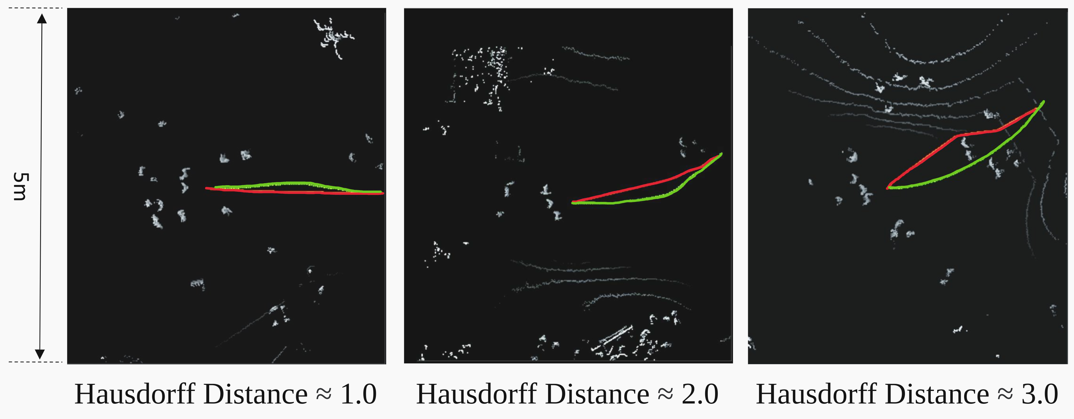
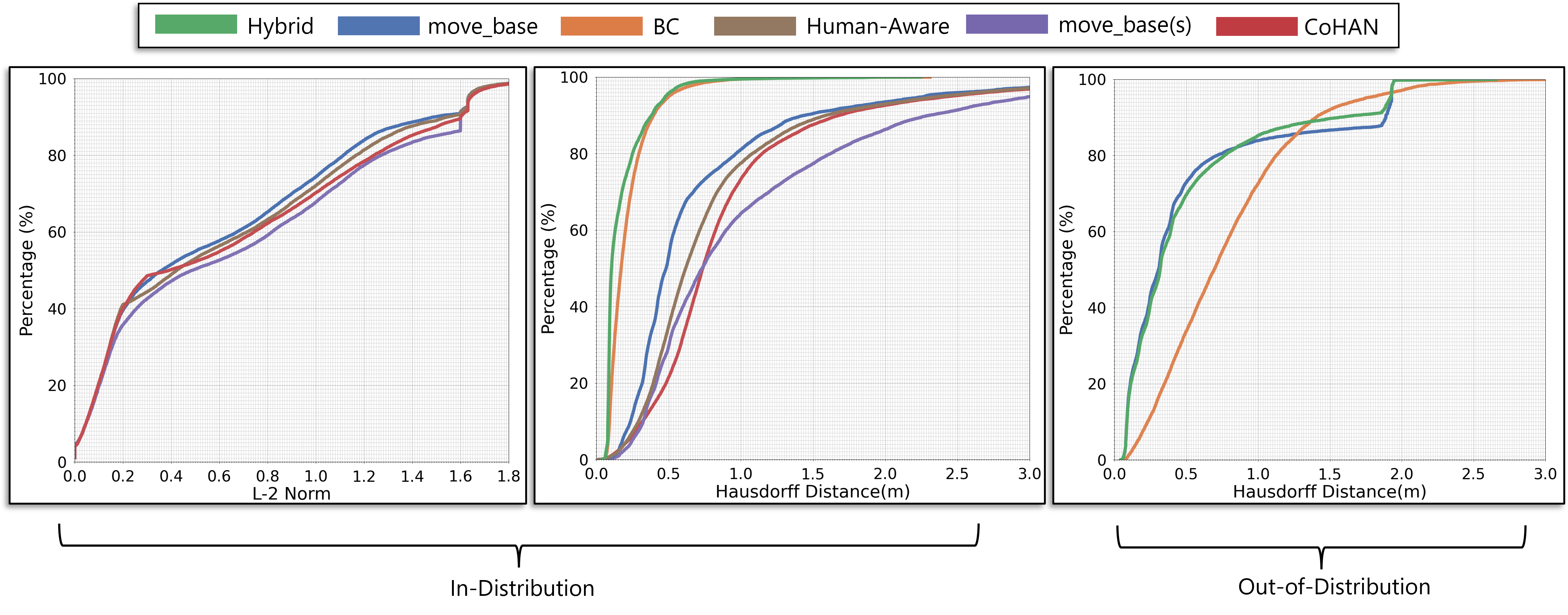
5.4.4 Anticipated Use Cases of SCAND
Although scand includes a wide variety of social navigation scenarios, there may be novel interactions that are less frequent. To improve the generalizability of a learning-based approach to unseen situations, exploring representation learning for social navigation with scand is a promising future direction. scand was collected in a single city (Austin, Texas, USA) and might incorporate regional biases such as staying to the right of the road, or overtaking pedestrians from the left. This potential bias raises a need for algorithms, evaluations, and metrics for social navigation that are flexible enough to work in the presence of different local norms.
Evaluating social navigation policies is an active area of research in the navigation community (Pirk et al., 2022; Tsoi et al., 2020; Mavrogiannis et al., 2022; Biswas et al., 2021). While benchmarking social navigation policies is out of scope for this work, existing simulation-based navigation benchmarks such as SocNavBench by Biswas et al. (2021) that use human-only trajectories could be augmented and improved using human-robot interaction trajectories in scand. Similarly, another interesting future research direction is to explore Real-to-Sim transfer (Hanna et al., 2021; Desai et al., 2020a, b; Karnan et al., 2020) with scand and improve parameterized simulated social navigation environments to generate more realistic social interactions between virtual agents, directly benefiting data hungry approaches such as reinforcement learning.
Other directions for future work that could directly benefit from scand include trajectory prediction, trajectory classification, and inverse reinforcement learning for large-scale cost function learning. Previously, work on trajectory prediction and classification has used human-only (Shafiee et al., 2021) or robot-only (Zhu et al., 2021) trajectories, but with access to scand, exploring human-robot trajectories is an interesting direction for future work. The work by Wulfmeier et al. (2017) utilized static scenarios to learn a cost function for autonomous robot navigation using Maximum Entropy Deep Inverse Reinforcement Learning (medirl). Applying medirl on scand to learn cost functions that incorporate social compliance is also an interesting direction for future work.
5.5 A Hybrid Approach to Social Robot Navigation
Our social compliance case study shows that classical planners perform well in a majority of social scenarios in scand. However, as shown in Figure 5.11, the classical planners deviate significantly from the human demonstrations in a small percentage of the dataset. On the other hand, learning-based approaches have been shown to enable emergent navigation behaviors (Bojarski et al., 2016), yet, in certain cases, tend to overfit and do not generalize well when facing out-of-distribution scenarios.
This observation motivates us to rethink how to take advantage of both classical and learning-based approaches. In this section, we first compare a widely used learning approach, Behavior Cloning (BC), with the best classical planner in our study, move_base, and show that building a completely new learning-based social navigation planner may not work as well as the classical planner. We then introduce our new hybrid approach (Raj et al., 2023) to leverage the best of both worlds555This work was a collaborative effort with coauthors from UT Austin and GMU and was accepted for publication at ICRA 2024 (Raj et al., 2023)..
5.5.1 Comparing BC with move_base
A commonly known issue for learning-based approaches is the lack of generalizability to out-of-distribution data. Therefore, in addition to training and testing on the original scand, we follow scand’s procedure and collect extra demonstrations in manually curated social scenarios (in contrast to in the wild), including intersection encounter, frontal approach, and people following. We also study the social compliance of both move_base and BC on this out-of-distribution test set.
For the original scand, as shown in Figure 5.11 middle, the CDF curves show that BC (orange) performs better than move_base (blue) on the in-distribution scand test set throughout the entire range, indicating that learning-based approaches can efficiently capture social compliance in in-distribution scenarios. For the out-of-distribution dataset collected to test generalizability, as shown in Figure 5.11 right, while move_base achieves similar performance compared to the in-distribution test data in the original scand, BC’s performance significantly deteriorates, seriously suffering from the commonly known distribution-shift problem of learning-based approaches. Although BC’s overall performance drops significantly, we can observe a trend that BC’s performance overtakes move_base’s performance at more challenging social scenarios, indicating that learning-based approaches have the potential to solve what classical approaches cannot solve.
5.5.2 Leveraging the Best of both Worlds
Our case study results suggest that (1) classical navigation systems can produce socially compliant navigation behaviors in a majority of social scenarios and (2) learning-based approaches (in our case, BC) have the potential to solve challenging social scenarios where classical approaches fail to be socially compliant. Therefore, we propose a new framework where the classical navigation system acts as a backbone, which is complemented by a learning-based approach for handling difficult social navigation scenarios. To be specific, we instantiate our hybrid navigation planner based on a classical navigation planner , a learning-based planner with learnable parameters , and a gating function with learnable parameters that selects between the output from the classical and learning-based planners:
| (5.1) |
The parameters and can be learned using supervised learning on the navigation scenario and behavior tuples in scand:
| (5.2) |
From among the many ways to learn and (either jointly or separately), in this work, we present a simple implementation that first learns a classifier based on the difference between and to choose between and :
| (5.3) |
can already produce socially compliant behaviors when , while only learns to address navigation scenarios where ( is a manually defined threshold).
To be specific, by comparing against , i.e., , we separate the original scand into a socially compliant and a socially non-compliant subset with respect to , and form a supervised dataset , in which if () and if (). Then, is learned via supervised learning with a cross-entropy loss to classify whether is socially compliant or not:
| (5.4) |
The learning-based planner is then learned to minimize the difference between its outputs and demonstrations in :
| (5.5) |
During deployment, first uses to classify if is socially compliant or not, and then executes if compliant or if not.
5.5.3 In- and Out-of-Distribution Experiment Results
We instantiate as a global planner using the move_base planner and generate the corresponding to train a BC planner. We apply our hybrid planner on both the original scand and the out-of-distribution test set. As shown in Figure 5.11 middle, our hybrid approach (green) imitates a larger percentage of scand social scenarios with smaller Hausdorff distance in contrast to move_base (blue) and BC (orange). For the out-of-distribution test set, as shown in Figure 5.11 right, our hybrid approach does not suffer from the significant performance degradation experienced by BC and achieves similar performance as move_base with small Hausdorff distance. At a large distance, our hybrid approach is able to improve upon move_base and approach BC. Our results in Figure 5.11 verify our hypothesis that the hybrid approach can take advantage of the best of both worlds facing both in-distribution and out-of-distribution social navigation scenarios.
5.5.4 Physical Experiments
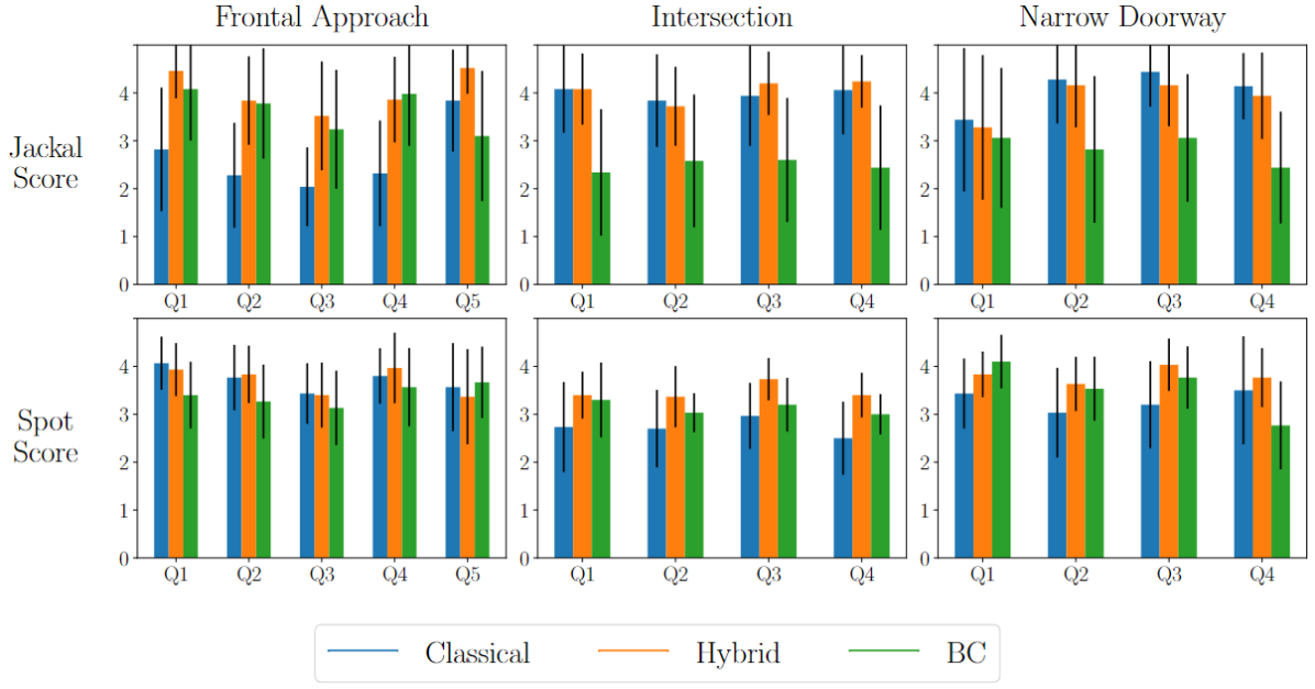
| Jackal | Frontal | Intersection | Doorway |
| Classical | |||
| Hybrid | |||
| BC | |||
| Spot | Frontal | Intersection | Doorway |
| Classical | |||
| Hybrid | |||
| BC |
We conduct a human study in a series of physical experiments to assess the social compliance of our proposed hybrid approach, in comparison to an existing classical planner, i.e., move_base, and an end-to-end learning-based method, i.e., BC trained on scand. The experiments are conducted using a wheeled Clearpath Jackal and a legged Boston Dynamics Spot to show the generalizability of our proposed hybrid approach to robots with different morphologies on two university campuses, George Mason University (GMU) and The University of Texas at Austin (UTA), respectively. We test the robots’ social compliance within three distinct social scenarios, i.e., Frontal Approach, Intersection, and Narrow Doorway. We keep the same setup of our hybrid approach among all three scenarios. The three methods are randomly shuffled and repeated five times, and human participants are requested to respond to a questionnaire with 4-5 questions using Likert scales (Pirk et al., 2022; Xiao et al., 2022b) following each run. Each scenario is tested on ten different individuals (fifteen interactions per individual).
5.5.4.1 Social Compliance Questionnaire
For the Frontal Approach, the five assessments posed to the human participants are as follows666∗ denotes negatively formulated questions, for which we reverse-code the ratings to make them comparable to the positively formulated ones..
-
1.
The robot moved to avoid me.
-
2.
The robot obstructed my path∗.
-
3.
The robot maintained a safe and comfortable distance at all times.
-
4.
The robot nearly collided with me∗.
-
5.
It was clear what the robot wanted to do.
For Intersection, the four assessments were as follows.
-
1.
The robot let me cross the intersection by maintaining a safe and comfortable distance.
-
2.
The robot changed course to let me pass.
-
3.
The robot paid attention to what I was doing.
-
4.
The robot slowed down and stopped to let me pass.
For Narrow Doorway, the four assessments asked were as follows.
-
1.
The robot got in my way∗.
-
2.
The robot moved to avoid me.
-
3.
The robot made room for me to enter or exit.
-
4.
It was clear what the robot wanted to do.
The quantitative results of our experiments are shown in Figure 5.12, where we plot the per-question average along with error bars for the three methods in each of the scenarios.
5.5.4.2 Jackal Experiments at GMU
In the experiments conducted at George Mason University (GMU) using the wheeled Jackal robot,777The research described in this section was conducted in collaboration with Xuesu Xiao, Amir Hossain Raj, and Amirreza Payandeh from George Mason University, and Zichao Hu, Rohan Chandra, Luisa Mao, Joydeep Biswas, and Peter stone from The University of Texas at Austin. our hybrid approach demonstrated notably distinct social behaviors during frontal approach, ensuring a safe distance when passing directly opposite a pedestrian. In contrast, for the other two scenarios, our hybrid method predominantly relied on the classical planner, leading to behaviors that were similar to those of the classical approach. Conversely, Behavior Cloning (BC) displayed variability across most trials: it either failed to achieve the designated objective, as reflected by the low BC scores for the Jackal Frontal Approach Q5 and Jackal Narrow Doorway Q4 (illustrated in the top left and top right of Figure 5.12, respectively), or necessitated manual intervention to prevent potential collisions with the human participant or the environment. Across the different scenarios, we observe that our approach remains consistent by maintaining the highest average in most of the questions. For both the GMU and UT Austin experiments, we run a one-way ANOVA test on the data from each question with three groups, and the test confirms the statistical significance of the comparison at a 95% confidence level. We show the Jackal Frontal Approach experiment in Figure 5.13 left as an example: the classical approach follows a trajectory which passes very close to the human; BC avoids the human but it cannot recover back to the correct trajectory and gets too close to the wall before we manually intervene; the hybrid approach reacts early by maintaining a safe distance to the human and successfully reaches the goal.
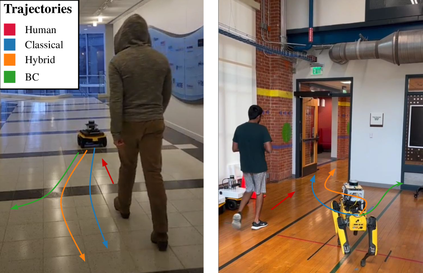
5.5.4.3 Spot Experiments at UT Austin
We also conduct experiments with a legged Spot at The University of Texas at Austin. In general, we observe that our hybrid approach still performs the most consistently across all three scenarios. However, the classical planner’s performance is slightly worse compared to the GMU Jackal experiments. It does not perform well on Spot Intersection (Figure 5.12 lower middle) and Spot Narrow Doorway (Figure 5.12 lower right, except Q4 since unlike BC, the classical approach can always reach the goal). We hypothesize that this discrepancy is caused by the different motion morphology of the Spot: legged robots are holonomic, and like humans, it is possible for them to side-step during social interaction. Not being able to do so due to the limitation of move_base may cause its movement to be perceived as unnatural. BC performs slightly better for Spot in Intersection (Figure 5.12 lower middle) and Narrow Doorway (Figure 5.12 lower right). We show the Spot Narrow Doorway experiment in Figure 5.13 right as an example: the classical approach first follows the shortest path until it gets close to the human and avoids the human; BC avoids the human but gets lost thereafter; the hybrid approach can slow down and avoid the human in the beginning and successfully pass the narrow doorway in the end.
5.6 Conclusion
In this chapter, as outlined in Section 1.1, I focus on the problem of socially compliant robot navigation in the presence of dynamic objects such as humans in the vicinity of the robot. This chapter introduced two significant contributions aimed at enhancing the social adaptability of robot navigation in such dynamic settings.
The first is a large-scale dataset of demonstrations for socially compliant robot navigation, called Socially CompliAnt Navigation Dataset (scand) (Karnan et al., 2022a, b), collected by human operators teleoperating two robots in a socially compliant manner in indoor and outdoor environments within the UT Austin campus. We show through physical robot experiments in an indoor environment that applying imitation learning using behavior cloning on scand leads to navigation behaviors that are perceived by human participants to be more socially compliant and safer than the heuristic-based move_base navigation stack. I additionally provide several analyses on the scand dataset to study social robot navigation.
The second contribution is a novel hybrid approach to improve the social compliance of robot navigation, by combining the benefits of a learning-based and heuristic-based classical navigation stacks. We show through physical robot experiments that the navigation behavior is perceived to be safe and socially compliant by several human participants in indoor environments across two different university campuses.
The previous chapters in this dissertation introduced the voila, sterling, and patern algorithms that utilize different forms of human feedback to learn navigation behaviors that are in alignment with operator intentions and preferences. However, they assume a static environment and do not consider dynamic objects such as humans in the scene, which are a common occurrence in the physical world where autonomous robots are increasingly being deployed. The two contributions presented in this chapter significantly advance the state-of-the-art in mobile robot navigation in dynamic environments, and together with the contributions from previous chapters, enable robot navigation that is in alignment with human intentions and preferences in both static and dynamic environments.
Chapter 6 Conclusion and Future Work
In this chapter, I summarize the contributions of this dissertation and additionally outline the potential avenues for future research that the contributions of this thesis open up.
In this dissertation, I introduced several contributions, as was initially outlined in Section 1.1 that address the problem of value misalignment in autonomous mobile robots. As embodied AI agents become increasingly intelligent and autonomous due to advancements in machine learning and accelerated computing hardware, it is paramount to ensure that their internal navigation objectives and behaviors are in alignment with human intentions and preferences. This thesis therefore seeks to answer the following question:
How can machine learning methods be applied to the task of autonomous navigation in unstructured environments such that the learned navigation behaviors of mobile robots align with the intentions and preferences of humans?
To answer this question, this thesis utilizes the learning from demonstrations and learning from preferences framework to learn navigation objectives and policies that align with the intentions and preferences of humans that are reflected in the demonstrations and preference queries. I first introduced voila, an online visual imitation learning algorithm that learns from video-only demonstrations from physically different agents such as humans, overcoming the issue of egocentric viewpoint mismatch that poses a major challenge for existing visual imitation learning algorithms. I then introduced sterling, a self-supervised terrain representation learning algorithm that facilitates operator terrain preference-aligned navigation in outdoor environments. Additionally, I introduced patern which complements sterling by using a self-supervised learning procedure to extrapolate operator preferences to visually novel terrains. All three algorithms voila, sterling, and patern enable a mobile robot to navigate in static indoor and outdoor environments in alignment with a human operator’s intentions and preferences. Finally, in the context of navigation in dynamic situations such as in the presence of humans, I introduce scand, a large-scale dataset of demonstrations that facilitates imitation learning to learn socially compliant navigation policies and a novel hybrid approach for socially compliant robot navigation. I showed that learning a navigation policy through imitation learning on scand leads to behaviors that are perceived to be safe and socially compliant, and additionally combining the learned policy with a heuristic-based navigation policy leads to improved performance. In all contributions, we show through physical robot experiments that the approaches enable navigation behaviors that are in alignment with the human’s intentions and preferences.
6.1 Summary of Contributions
As first presented in Section 1.1, this dissertation provides the following contributions:
1. Visual Imitation Learning for Robot Navigation:
In Chapter 3, I introduced Visual Observation only Imitation Learning for Autonomous navigation (voila) (Karnan et al., 2021),111voila was published in the conference proceedings of ICRA 2022, held in Philadephia, USA. an imitation learning algorithm that learns from video-only demonstrations from a physically different expert, such as a human, overcoming egocentric viewpoint mismatch, a significant limitation of existing visual imitation learning algorithms. voila addresses this problem by introducing a novel reward function that is invariant to viewpoint mismatch. The novel reward function in voila uses existing local keypoint detection algorithms such as superpoint (DeTone et al., 2018) that are themselves designed to be robust to viewpoint mismatches. By introducing a demonstration-dependent novel reward function that is optimized using an off-policy reinforcement learning algorithm on the robot, voila addresses the imitation learning problem using reinforcement learning. On both simulated and physical robot experiments, we find that voila learns to successfully imitate the expert demonstrations from physically different experts and produces navigation behaviors that are in alignment with the human operator’s intentions, as demonstrated in the demonstrations.
2. Preference-Aligned Off-Road Navigation:
In Chapter 4, I introduced two contributions, focusing on the problem of aligning a mobile robot’s off-road navigation behaviors with a human operator’s preferences over terrains.
The first contribution is an algorithm named Self-supervised TErrain Representation LearnING (sterling) (Karnan et al., 2023a, b) 222sterling was published in the conference proceedings of CoRL 2023, held in Atlanta, USA., that focuses on self-supervised learning of terrain preferences followed by query-based operator preference learning to enable preference-aligned off-road navigation. Prior approaches require large-scale human annotated datasets that may be difficult to curate or require diverse and constrained human demonstrations in the field that may not always be feasible to collect. sterling overcomes these challenges by learning relevant representations of terrains in a non-contrastive, self-supervised manner by leveraging unconstrained trajectories of multi-modal sensor information recorded on the robot. Through physical robot experiments on the Spot and Jackal robots, we observed that in comparison to several state-of-the-art baseline methods, sterling enables operator preference-aligned off-road navigation.
The second contribution is an algorithm named Preference extrApolation for Terrain-awarE Robot Navigation (patern) (Karnan et al., 2023d; Yang et al., 2023) 333patern is accepted for publication at the ICRA 2024 conference., that focuses on extrapolating operator preferences from known to visuall novel terrains. A mobile robot operating autonomously in off-road terrains might encounter terrains that are outside the known distribution of terrains seen during training. In such scenarios where the robot is faced with unfamiliar terrain, the standard approach is to query a human operator for their preferences in any form (Kahn et al., 2021b; Sikand et al., 2022; Karnan et al., 2023a) and update the robot’s navigation behavior offline to handle the novel terrain. However, this may be infeasible in many scenarios where requesting feedback in real-time from the operator may be delayed or impossible. patern addresses this problem by extrapolating operator preferences from known to visually novel terrains. In patern, we posit that in certain scenarios, where the novel terrain is visually dissimilar but similar to a known terrain in its non-visual observation space such as inertial, proprioceptive, or tactile signals, it may be possible to extrapolate operator preferences from known to visually novel terrains. patern leverages this intuition of utilizing multi-modal terrain observations and uses a self-supervised procedure to update the terrain preferences. Through physical robot experiments in diverse environments within the UT Austin university campus and on the 3-mile Ann and Roy Butler trail in Austin, TX, we observed that patern successfully extrapolates operator preferences on novel terrains and leads to behaviors that are compliant with an operator’s preferences of terrains.
3. Socially Compliant Robot Navigation:
In Chapter 5, I focus on the problem of socially compliant robot navigation. An autonomous mobile robot operating in the physical world might often encounter dynamic scenarios such as human-occupied environments during which it needs to act in a socially compliant manner to ensure the safety of both the human and the robot, and to improve the acceptance of service robots in human-occupied environments. Towards this end, in this chapter, I introduced two contributions—a large-scale dataset of demonstrations for socially compliant robot navigation, and a hybrid approach for socially compliant robot navigation.
The first contribution of this chapter is a large-scale dataset of demonstrations for socially compliant robot navigation. Previous datasets for social navigation (Martin-Martin et al., 2021) focus on the perception problem of robot navigation, such as visual detection of pedestrians and behavior prediction of moving humans. Addressing the lack of datasets to address the navigation component of socially compliant robot navigation, we introduce the Socially CompliAnt Navigation Dataset (scand), 444scand was published in the proceedings of RA-L 2022 and was presented at IROS 2022, held in Kyoto, Japan. a large-scale dataset of socially compliant robot navigation. scand consists of 138 trajectories, 25 miles of human-teleoperated demonstrations of a robot navigating in a socially compliant manner. We additionally found that using scand to learn a navigation policy using behavior cloning (Bain and Sammut, 1995) leads to navigation behaviors that are perceived to be safer and socially compliant than a classical navigation stack (ROS-Planning, 2022), as evidenced by a human participant study in an indoor environment.
The second contribution of this chapter is a novel hybrid algorithm to enable socially compliant navigation behaviors on mobile robots. 555The hybrid approach is accepted for publication at the ICRA 2024 conference. Through analysis of scand, we observed that a classical heuristic-based navigation stack, preferred in many robots for real-world scenarios due to its inherent safety guarantees, achieves social compliance in 80% of scenarios in scand. Additionally, while a learning-based planner learned using the scand dataset can handle special scenarios that require social compliance, it lacks the safety guarantees of classical methods, which prevents its wide adoption practically. To bridge this gap, we propose a novel hybrid approach that combines the benefits of learning-based and heuristic-based approaches to robot navigation. This approach uses a learned classifier that switches between a learning-based and heuristic-based navigation stack as appropriate, trained using the scand dataset. On physical robot experiments involving human participants conducted on two university campuses, we found that our hybrid approach is preferred by humans over classical or learning-based navigation stacks.
Figure 1.1 includes a flowchart summarizing the thesis question, problems, and their respective solutions proposed as contributions in individual chapters in this dissertation.
6.2 Future Work
The work presented in this dissertation presents several avenues for future work. This section is organized as follows. Section 6.2.1 summarizes and expands on the ideas already presented for future work in previous chapters. In Section 6.2.2, I discuss how recently successful large multi-modal foundation models trained with internet-scale data may be utilized for robot navigation, enabling alignment with operator preferences and intentions.
6.2.1 Summary of General Ideas for Future Work
In this section, I elaborate on ideas for future work that were briefly presented in earlier chapters of this dissertation.
6.2.1.1 Planner Parameter Learning Using VOILA
The voila approach introduced in Chapter 3 demonstrates successful visual imitation learning capabilities for navigation, using a parameterized neural network as the policy. However, as discussed in Chapter 5, end-to-end learned navigation policies represented as neural networks lack safety guarantees, a characteristic feature of classic heuristic-based navigation stacks. A potential avenue for future research is the integration of a parameterized classical navigation stack, such as move_base, in the role of the parameterized policy, as was previously explored in appld (Xiao et al., 2020a). Adopting this strategy could potentially enable visual imitation learning of behaviors from physically different agents while retaining the safety guarantees inherent in classical navigation methodologies.
6.2.1.2 Real-to-Sim and Sim-to-Real for Social Navigation
Leveraging simulators to learn socially compliant robot navigation using reinforcement learning is a promising alternative to imitation learning. Simulators offer the flexibility of generating synthetic data at more than real-time rates and allow orchestrating several multi-agent scenarios that may be hard to capture or observe in the real world. Additionally, simulators offer access to ground-truth labels of simulated assets, such as locations of humans in the scene, which may not be readily available from data collected in the real world. Moreover, simulators can serve as a standard benchmarking tool to evaluate several social navigation algorithms, a major challenge in the social navigation community (Francis et al., 2023).
However, existing simulators lack dynamic motion models that accurately model the navigation behavior of humans in the scene, thereby constraining their utility for online learning and benchmarking. Existing simulators typically employ either the social force model (Helbing and Molnár, 1995) or replay recorded trajectories of humans without closed-loop control (Biswas et al., 2021), which may not be an efficient way to evaluate all reactive social navigation algorithms. The physical world consists of a vast amount of social navigaton scenarios that are not modeled currently in existing social navigation simulators. A promising idea is to utilize the scand dataset and other sources of data, such as YouTube videos, to learn better human motion models and diverse social scenarios. Below, I outline two research directions, categorized as short-term and long-term challenges.
Short-Term Future Work: The scand dataset introduced in Chapter 5 offers numerous observations of human interactions, captured through lidar scans and camera data. These can serve as a foundation for developing human motion models akin to those proposed by Hirose et al. (2023). Although scand lacks direct labels of human positions in the scenes, one could employ large-scale pretrained vision-language models like Segment Anything (Kirillov et al., 2023) to infer human positions from visual data. This positional information may then be used to train a human motion prediction model, enhancing the fidelity of human movement simulation for more effective online learning and benchmarking of social navigation algorithms.
Long-Term Future Work: Although scand offers a substantial amount of data on social interactions involving a mobile robot and humans in various environments, it may not encompass all forms of social interactions, especially those that are rarer or less represented in scand. A valuable direction for future research could be to explore the use of large internet-scale data sources, like YouTube. This platform likely hosts a more diverse range of scenarios depicting social compliance. The primary challenge here lies in identifying and extracting specific instances of socially compliant navigation among autonomous entities such as humans from YouTube videos. Additionally, developing methodologies for effectively leveraging these passive demonstrations to enhance social navigation skills or to recreate the scenario in simulation remains an area to explore. In this context, the approach by Fan et al. (2022) in learning diverse open-ended agent abilities from Minecraft gameplay videos on YouTube offers a noteworthy precedent.
6.2.1.3 Imitating Multi-Modal Social Navigation Demonstrations
In this section, I describe two short-term directions for future work, including promising initial experimental results, on two ideas: learning a cost map using Maximum Entropy Deep Inverse Reinforcement Learning (medirl) (Wulfmeier et al., 2017; Zhu et al., 2020) and using Diffusion Policies (Chi et al., 2023) to learn a multi-modal motion planning policy for social navigation.
Deep Maximum Entropy IRL for Social Cost Function Learning: In this section, I motivate learning a costmap using the Maximum Entropy Inverse Reinforcement Learning approach (medirl), as was initially proposed by Ziebart et al. (2008) and extended using a non-linear fully convolutional network as the cost function by Wulfmeier et al. (2017). In comparison to policy learning using the mean squared error behavior cloning loss, learning a costmap using the maximum entropy IRL (Ziebart, 2010) takes a distribution matching approach, treating the demonstrations as a distribution, effectively handling multi-modality of the social navigation problem. Initial experiments on held-out data on the scand dataset show promising results in learning a costmap for social navigation, that may be extended to incorporate the time-dependence of the demonstrations to fully address the social navigation problem.
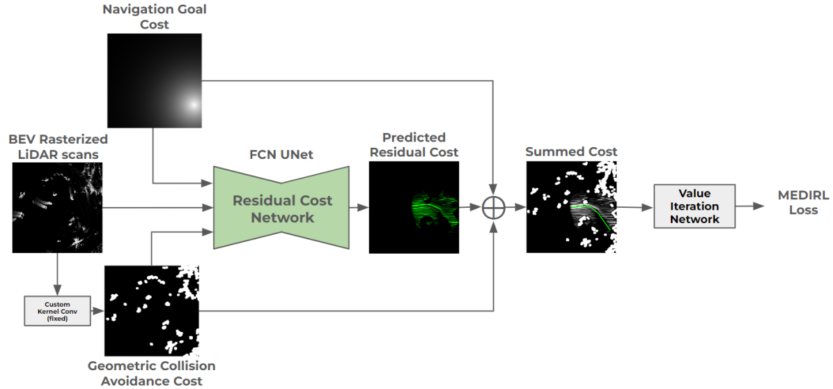
Figure 6.2 presents the residual social cost predicted by the cost function network on a held-out validation sample, as detailed in Figure 6.1, learned using the medirl approach. Notably, in a scenario where groups of people are situated ahead of the robot, the residual cost function network assigns a higher cost to the areas surrounding the group. This cost assignment effectively deters the robot from traversing through the crowd, guiding it instead along a path consistent with the human demonstrations observed in the scand dataset. This example demonstrates the potential of learning residual costs using medirl, highlighting it as a promising direction for future research.
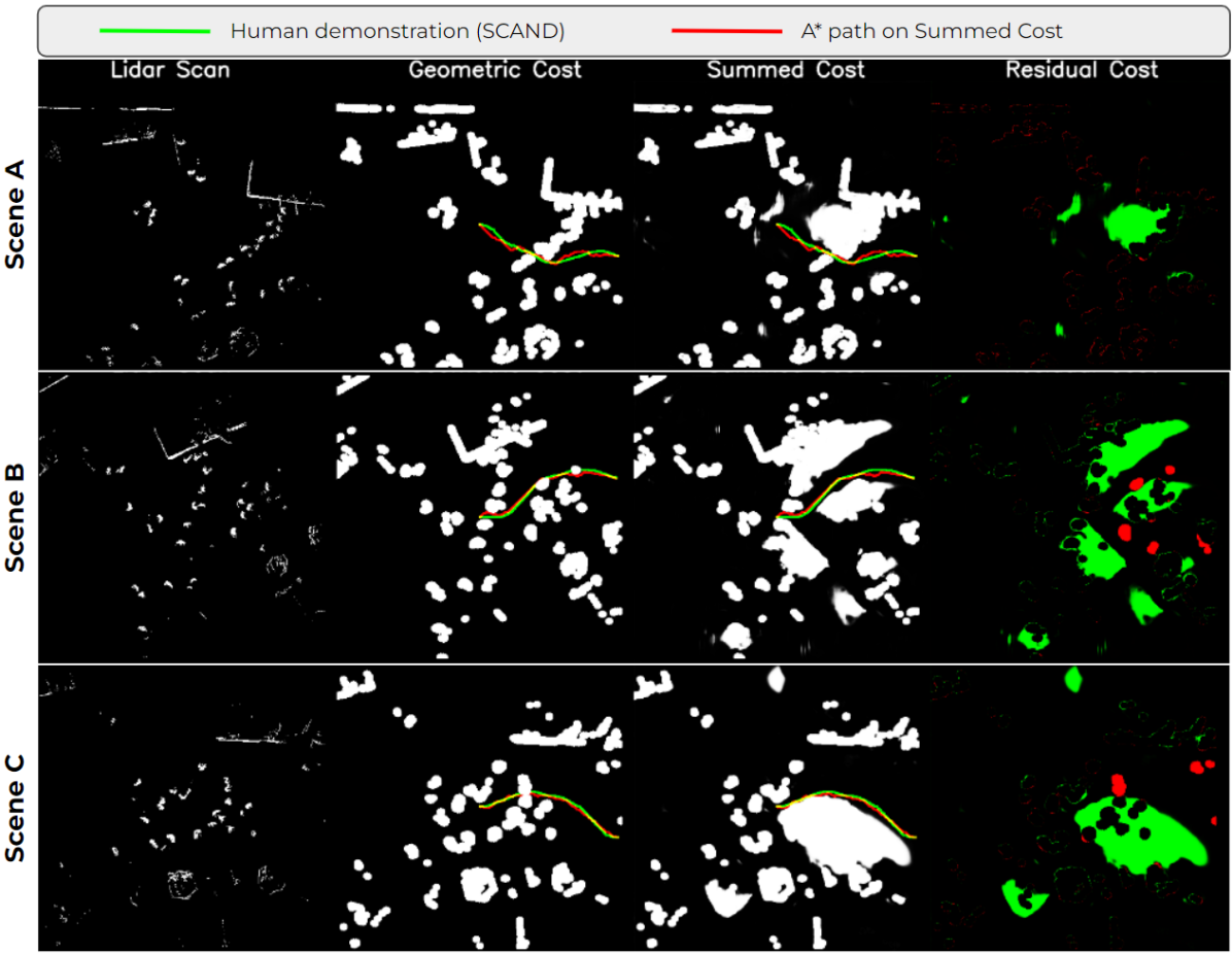
A key limitation of this IRL approach described above is the presumption that the residual social navigation cost (social) remains static. We employ a conventional planner, such as , that operates on static costmaps to plan the robot’s future positions in the cumulative costmap for a specific environment. However, this static framework may not adequately represent the dynamic nature of social navigation, particularly in scenarios where humans are moving within the scene, necessitating dynamic, time-dependent costs for . An interesting future work to explore in the short term is to extend the medirl approach to learn dynamic costmaps, similar to the work by Lee et al. (2022).
Diffusion Policy for Social Navigation: In this section, I investigate preliminary short-term future work of leveraging diffusion as a promising generative modeling approach to learn multi-modal local motion planning policies for social robot navigation. In the domain of language-guided image generation, diffusion has been transformative with successful methods such as dall-e (dal, 2021) generating superior-quality images than its predecessors. The recent diffusion policy paper by Chi et al. (2023) showed the successful application of diffusion to learn a local motion planning policy for robot manipulation tasks. Diffusion is a promising alternative to Gaussian mixture models (Jaquier et al., 2020) in capturing the multi-modality of demonstrations, overcoming mode-collapse, and capturing diverse modes of data, as evidenced in prior work (Chi et al., 2023).
To evaluate simple behavior cloning, behavior cloning with Gaussian mixture models, and behavior cloning with diffusion policy, we consider a social navigation scene involving a T-junction interaction, where the robot and the human stand facing each other at an open intersection, and walk towards a goal 10 meters ahead, their paths intersecting at a common point, as shown in Figure 6.3. We specifically picked this scenario since there is more than one way to navigate in a socially compliant manner. For instance, the robot could either yield for the human to pass by pausing momentarily, or not yield and expect the human to yield, thereby walking towards its goal without yielding. Using the simple behavior cloning approach that does not model the multi-modality of the target demonstration distribution, we expect the approach to learn the mean of the two modes, resulting in a suboptimal behavior. Using a Gaussian Mixture model on the other hand is known to suffer from mode-collapse and getting stuck in local minima, whereas diffusion has been known to learn consistent behaviors, effectively capturing multi-modality in the demonstrations.
Figure 6.4 shows the results of the three algorithms, trained on the training set in scand, deployed here on the T-junction scenario involving a dynamic human walking across the robot. In this scene, the human does not yield to the robot, and one of the optimal, socially compliant behaviors to prevent collisions or obstructing the human’s motion is to pause and let the human pass. In Figure 6.4, we see that the diffusion policy leads to such behaviors where the path predicted by the learned motion planner constricts the robot’s motion in the future, waits for the human to pass, and then proceeds to move towards the goal. This preliminary experiment on the T-junction scenario shows that social scenarios that are relatively hard to solve with simple behavior cloning may be solved now through improved methods, such as diffusion (Chi et al., 2023). An interesting direction for future work is to include other social navigation datasets, such as MuSoHu by Nguyen et al. (2023), and explore input data augmentations during training of the diffusion policy to handle diverse scenes.
6.2.1.4 Learning to Balance Navigation Costs from Demonstrations
In the off-road navigation work presented in Section 4, we utilized a sampling-based motion planner that greedily picks the optimal trajectory arc, guided by an objective function integrating two distinct costs: geometric and preference-based. During the physical robot experiments in Sections 4.4.5 and 4.5.4, we manually adjusted the coefficient that balances these costs, a process that necessitates specialized human expertise. An interesting idea for future work in the short-term is to identify the ideal cost-balancing coefficient through imitation learning from expert demonstrations, a less cognitively demanding form of human feedback, thereby enabling the alignment of off-road behavior with operator intentions.
6.2.2 Utilizing Foundation Models in Robot Navigation
In this section, I present several short-term ideas for future work that expand upon the contributions of this dissertation, by utilizing recently successful multi-modal foundation models trained with internet-scale data.
6.2.2.1 Scene Description-based Visual Alignment
Unlike voila, rather than estimating reward feedback by matching video-only demonstrations and imitator observations, an alternative approach for aligning with the operator’s intentions involves computing rewards through the correlation of language descriptions of the scene between the imitator and the expert’s experience. To facilitate imitating video-only demonstrations from physically different experts, voila utilized a demonstration-dependent reward function that was optimized using reinforcement learning. voila enables alignment by matching the imitator and expert observations using a local feature detector that is robust to viewpoint mismatches and then maximizing the match density. Recent advancements have seen large-scale multi-modal models, especially vision-language models (Radford et al., 2021a; Li et al., 2023; Iinuma et al., 2023), excel in reasoning by integrating visual scene observations with corresponding natural language descriptions (Firoozi et al., 2023; Collaboration et al., 2023; Bommasani et al., 2022; Touvron et al., 2023). A related approach that does not involve online learning, but utilizes vision-language models such as blipv2 (Li et al., 2023) was explored by Yokoyama et al. (2023). Combining voila’s reinforcement-learning-based approach for visual imitation learning with the emerging developments in large-scale multi-modal vision-language models is an interesting research trajectory for future investigations.
6.2.2.2 Application of Foundation Models to Off-Road Navigation
Foundation models, characterized by their extensive parameterization and trained on massive datasets, offer a versatile backbone for diverse downstream tasks. In the domain of off-road navigation, recently, there have been several datasets made publically available that contain robot experience collected in diverse off-road environments (Wigness et al., 2019; Jiang et al., 2021, 2020; Triest et al., 2022). An interesting direction to explore is to either pre-train a large-scale foundation model or fine-tune an existing model that can aid in visual terrain awareness of a mobile robot’s navigation behavior on several downstream tasks such as preference-aligned navigation (Karnan et al., 2023a, c) or high-speed off-road driving (Karnan et al., 2022c).
Historically, self-supervised learning in off-road navigation has been narrowly focused on task-specific representations. However, the sterling approach represents a significant advance, offering general, task-agnostic terrain representations through non-contrastive self-supervised learning. This approach could serve as an effective pretraining strategy for a foundation model geared toward off-road navigation. Currently, existing vision-encoder models, including sterling, are limited to a handful of terrains and lack training on extensive, internet-scale datasets. By pretraining a foundation model for terrain-aware navigation, we could vastly improve adaptability across various terrains, making it instrumental in a range of off-road applications such as agriculture, high-speed racing, and search and rescue missions.
6.2.2.3 Application of Foundation Models to Social Navigation
To enable autonomous mobile robots to navigate in a socially compliant manner, they must effectively perceive their surroundings, infer the goals and potential intentions of nearby agents such as humans and other robots, and balance their objectives with those of others, employing communication when required to generate navigation behaviors that are perceived to be socially compliant. Recent foundation models, such as LLaVA (Liu et al., 2023), have exhibited remarkable performance in perception and language-based scene comprehension, essential for everyday tasks. Utilizing these large-scale foundation models pretrained from internet-scale data to bootstrap from and perform scene understanding and human intent recognition, one of the critical features necessary for social navigation, represents a promising avenue for future work.
6.3 Concluding Remarks
The increasing deployment of autonomous mobile robots in human-centric environments underscores the critical need for their navigational objectives and behaviors to be in alignment with those of their human operators. Learning from human demonstrations and human preference feedback is a powerful tool in imitation learning to address the value alignment problem. In this dissertation, I introduced several novel machine-learning algorithms and a large-scale dataset to align the behaviors of mobile robots with the intentions and preferences of humans. The findings demonstrate a substantial improvement in aligning robot navigation behaviors with human intentions and preferences, marking a significant advancement in the field of mobile robot navigation.
Acronyms
- AMRL
- Autonomous Mobile Robotics Laboratory
- BC
- Behavior Cloning
- CNN
- Convolutional Neural Networks
- DNN
- Deep Neural Networks
- DQN
- Deep Q Networks
- EM
- Expectation Maximization
- FCN
- Fully Connected Networks
- GAIL
- Generative Adversarial Imitation Learning
- GAIfO
- Generative Adversarial Imitation from Observation
- GAN
- Generative Adversarial Networks
- GANAV
- Group-wise Attention for Navigation
- GARAT
- Generative Adversarial Reinforced Action Transformation
- GAT
- Grounded Action Transformation
- GMU
- George Mason University
- ICRA
- International Conference on Robotics and Automation
- IL
- Imitation Learning
- IRL
- Inverse Reinforcement Learning
- IROS
- International Conference on Intelligent Robots and Systems
- JS
- Jensen-Shannon
- KL
- Kullback Leibler
- LAND
- Learning to Navigate from Disengagements
- LARG
- Learning Agents Research Group
- LfD
- Learning from Demonstrations
- LfP
- Learning from Preferences
- MDP
- Markov Decision Process
- MLE
- Maximum Likelihood Estimate
- POMDP
- Partially Observable Markov Decision Process
- PPO
- Proximal Policy Optimization
- RCA
- Ride Comfort Aware Navigation
- RA-L
- Robotics and Automation Letters
- RL
- Reinforcement Learning
- SAC
- Soft Actor Critic
- TPIL
- Third Person Imitation Learning
- TRPO
- Trust Region Policy Optimization
- UTA
- The University of Texas at Austin
References
- (1) Amazon scout:. https://www.aboutamazon.com/news/transportation/meet-scout. Accessed: 2022-08-31.
- Gua (2017) “Our streets are made for people”: San francisco mulls ban on delivery robots. https://www.theguardian.com/sustainable-business/2017/may/31/delivery-robots-drones-san-francisco-public-safety-job-loss-fears-marble, 2017. Accessed: 2022-08-31.
- dal (2021) DALL·E. OpenAI, 2021. URL https://openai.com/dall-e.
- Sid (2022) Toronto bans automated robots from sidewalk operation until further study. https://smartcitiesconnect.org/toronto-bans-automated-robots-from-sidewalk-operation-until-further-study/, 2022. Accessed: 2022-08-31.
- Abbeel and Ng (2004) Pieter Abbeel and Andrew Y Ng. Apprenticeship learning via inverse reinforcement learning. In Proceedings of the twenty-first international conference on Machine learning, page 1, 2004.
- Amodei et al. (2016) Dario Amodei, Chris Olah, Jacob Steinhardt, Paul Christiano, John Schulman, and Dan Mané. Concrete problems in ai safety, 2016. URL https://arxiv.org/abs/1606.06565.
- Arandjelović et al. (2016) Relja Arandjelović, Petr Gronat, Akihiko Torii, Tomas Pajdla, and Josef Sivic. Netvlad: Cnn architecture for weakly supervised place recognition, 2016.
- Argall et al. (2009) Brenna D Argall, Sonia Chernova, Manuela Veloso, and Brett Browning. A survey of robot learning from demonstration. Robotics and autonomous systems, 57(5):469–483, 2009.
- Atreya et al. (2022a) Pranav Atreya, Haresh Karnan, Kavan Singh Sikand, Xuesu Xiao, Sadegh Rabiee, and Joydeep Biswas. High-speed accurate robot control using learned forward kinodynamics and non-linear least squares optimization, 2022a.
- Atreya et al. (2022b) Pranav Atreya, Haresh Karnan, Kavan Singh Sikand, Xuesu Xiao, Sadegh Rabiee, and Joydeep Biswas. High-speed accurate robot control using learned forward kinodynamics and non-linear least squares optimization. In Intelligent Robots and Systems (IROS), IEEE/RSJ International Conference on, pages 11789–11795. IEEE, 2022b. doi: 10.1109/IROS47612.2022.9981259.
- Baghi and Dudek (2021) Bobak H Baghi and Gregory Dudek. Sample efficient social navigation using inverse reinforcement learning. arXiv preprint arXiv:2106.10318, 2021.
- Bain and Sammut (1995) Michael Bain and Claude Sammut. A framework for behavioural cloning. In Machine Intelligence 15, 1995.
- Bain and Sammut (1999) Michael Bain and Claude Sammut. A framework for behavioural cloning. In Machine Intelligence 15, Intelligent Agents [St. Catherine’s College, Oxford, July 1995], page 103–129, GBR, 1999. Oxford University. ISBN 0198538677.
- Bardes et al. (2021) Adrien Bardes, Jean Ponce, and Yann LeCun. Vicreg: Variance-invariance-covariance regularization for self-supervised learning. arXiv preprint arXiv:2105.04906, 2021.
- Bi et al. (2018) Jing Bi, Tianyou Xiao, Qiuyue Sun, and Chenliang Xu. Navigation by imitation in a pedestrian-rich environment. ArXiv, abs/1811.00506, 2018.
- Biswas et al. (2021) Abhijat Biswas, Allan Wang, Gustavo Silvera, Aaron Steinfeld, and Henny Admoni. Socnavbench: A grounded simulation testing framework for evaluating social navigation, 2021.
- Biswas (2013) Joydeep Biswas. Amrl autonomy stack. https://github.com/ut-amrl/graph_navigation, 2013.
- Biswas and Veloso (2013) Joydeep Biswas and Manuela M. Veloso. Localization and navigation of the cobots over long-term deployments. The International Journal of Robotics Research, 32(14):1679–1694, 2013. doi: 10.1177/0278364913503892. URL http://ijr.sagepub.com/content/32/14/1679.abstract.
- Bobu et al. (2020) Andreea Bobu, Dexter RR Scobee, Jaime F Fisac, S Shankar Sastry, and Anca D Dragan. Less is more: Rethinking probabilistic models of human behavior. In Proceedings of the 2020 acm/ieee international conference on human-robot interaction, pages 429–437, 2020.
- (20) Mariusz Bojarski, Davide Del Testa, Daniel Dworakowski, Bernhard Firner, Beat Flepp, Prasoon Goyal, Lawrence D. Jackel, Mathew Monfort, Urs Muller, Jiakai Zhang, Xin Zhang, Jake Zhao, and Karol Zieba. End to end learning for self-driving cars.
- Bojarski et al. (2016) Mariusz Bojarski, Davide Del Testa, Daniel Dworakowski, Bernhard Firner, Beat Flepp, Prasoon Goyal, Lawrence D. Jackel, Mathew Monfort, Urs Muller, Jiakai Zhang, Xin Zhang, Jake Zhao, and Karol Zieba. End to end learning for self-driving cars, 2016. URL https://arxiv.org/abs/1604.07316.
- Bommasani et al. (2022) Rishi Bommasani, Drew A. Hudson, Ehsan Adeli, Russ Altman, Simran Arora, Sydney von Arx, Michael S. Bernstein, Jeannette Bohg, Antoine Bosselut, Emma Brunskill, Erik Brynjolfsson, Shyamal Buch, Dallas Card, Rodrigo Castellon, Niladri Chatterji, Annie Chen, Kathleen Creel, Jared Quincy Davis, Dora Demszky, Chris Donahue, Moussa Doumbouya, Esin Durmus, Stefano Ermon, John Etchemendy, Kawin Ethayarajh, Li Fei-Fei, Chelsea Finn, Trevor Gale, Lauren Gillespie, Karan Goel, Noah Goodman, Shelby Grossman, Neel Guha, Tatsunori Hashimoto, Peter Henderson, John Hewitt, Daniel E. Ho, Jenny Hong, Kyle Hsu, Jing Huang, Thomas Icard, Saahil Jain, Dan Jurafsky, Pratyusha Kalluri, Siddharth Karamcheti, Geoff Keeling, Fereshte Khani, Omar Khattab, Pang Wei Koh, Mark Krass, Ranjay Krishna, Rohith Kuditipudi, Ananya Kumar, Faisal Ladhak, Mina Lee, Tony Lee, Jure Leskovec, Isabelle Levent, Xiang Lisa Li, Xuechen Li, Tengyu Ma, Ali Malik, Christopher D. Manning, Suvir Mirchandani, Eric Mitchell, Zanele Munyikwa, Suraj Nair, Avanika Narayan, Deepak Narayanan, Ben Newman, Allen Nie, Juan Carlos Niebles, Hamed Nilforoshan, Julian Nyarko, Giray Ogut, Laurel Orr, Isabel Papadimitriou, Joon Sung Park, Chris Piech, Eva Portelance, Christopher Potts, Aditi Raghunathan, Rob Reich, Hongyu Ren, Frieda Rong, Yusuf Roohani, Camilo Ruiz, Jack Ryan, Christopher Ré, Dorsa Sadigh, Shiori Sagawa, Keshav Santhanam, Andy Shih, Krishnan Srinivasan, Alex Tamkin, Rohan Taori, Armin W. Thomas, Florian Tramèr, Rose E. Wang, William Wang, Bohan Wu, Jiajun Wu, Yuhuai Wu, Sang Michael Xie, Michihiro Yasunaga, Jiaxuan You, Matei Zaharia, Michael Zhang, Tianyi Zhang, Xikun Zhang, Yuhui Zhang, Lucia Zheng, Kaitlyn Zhou, and Percy Liang. On the opportunities and risks of foundation models, 2022.
- Brooks and Iagnemma (2007) Christopher A Brooks and Karl D Iagnemma. Self-supervised classification for planetary rover terrain sensing. In 2007 IEEE aerospace conference, pages 1–9. IEEE, 2007.
- Brown et al. (2019) Daniel Brown, Wonjoon Goo, Prabhat Nagarajan, and Scott Niekum. Extrapolating beyond suboptimal demonstrations via inverse reinforcement learning from observations. In International conference on machine learning, pages 783–792. PMLR, 2019.
- Brown et al. (2021) Daniel S Brown, Jordan Schneider, Anca Dragan, and Scott Niekum. Value alignment verification. In International Conference on Machine Learning, pages 1105–1115. PMLR, 2021.
- (26) Nicholas Carlevaris-Bianco, Arash K Ushani, and Ryan M Eustice. University of michigan north campus long-term vision and lidar dataset. The International Journal of Robotics Research, 35(9).
- Castro et al. (2023) Mateo Guaman Castro, Samuel Triest, Wenshan Wang, Jason M. Gregory, Felix Sanchez, John G. Rogers III au2, and Sebastian Scherer. How does it feel? self-supervised costmap learning for off-road vehicle traversability, 2023.
- Chan (2017) Fu-Hsiang Chan. Anticipating Accidents in Dashcam Videos. https://aliensunmin.github.io/project/dashcam/, 2017.
- Chang et al. (2020) Matthew Chang, Arjun Gupta, and Saurabh Gupta. Semantic visual navigation by watching youtube videos. CoRR, abs/2006.10034, 2020. URL https://arxiv.org/abs/2006.10034.
- Chaplot et al. (2021) Devendra Singh Chaplot, Deepak Pathak, and Jitendra Malik. Differentiable spatial planning using transformers, 2021. URL https://arxiv.org/abs/2112.01010.
- Chen et al. (2023) Eric Chen, Cherie Ho, Mukhtar Maulimov, Chen Wang, and Sebastian Scherer. Learning-on-the-drive: Self-supervised adaptation of visual offroad traversability models, 2023.
- Chen et al. (2018) Yu Fan Chen, Michael Everett, Miao Liu, and Jonathan P. How. Socially aware motion planning with deep reinforcement learning, 2018.
- Chi et al. (2023) Cheng Chi, Siyuan Feng, Yilun Du, Zhenjia Xu, Eric Cousineau, Benjamin Burchfiel, and Shuran Song. Diffusion policy: Visuomotor policy learning via action diffusion. arXiv preprint arXiv:2303.04137, 2023.
- Chung and Huang (2012) Shu-Yun Chung and Han-Pang Huang. Incremental learning of human social behaviors with feature-based spatial effects. In 2012 IEEE/RSJ International Conference on Intelligent Robots and Systems (IROS), pages 2417–2422, 2012.
- Codevilla et al. (2017) Felipe Codevilla, Matthias Müller, Alexey Dosovitskiy, Antonio M. López, and Vladlen Koltun. End-to-end driving via conditional imitation learning. 2017.
- Collaboration et al. (2023) Embodiment Collaboration, Abhishek Padalkar, Acorn Pooley, Ajay Mandlekar, Ajinkya Jain, Albert Tung, Alex Bewley, Alex Herzog, Alex Irpan, Alexander Khazatsky, Anant Rai, Anikait Singh, Animesh Garg, Anthony Brohan, Antonin Raffin, Ayzaan Wahid, Ben Burgess-Limerick, Beomjoon Kim, Bernhard Schölkopf, Brian Ichter, Cewu Lu, Charles Xu, Chelsea Finn, Chenfeng Xu, Cheng Chi, Chenguang Huang, Christine Chan, Chuer Pan, Chuyuan Fu, Coline Devin, Danny Driess, Deepak Pathak, Dhruv Shah, Dieter Büchler, Dmitry Kalashnikov, Dorsa Sadigh, Edward Johns, Federico Ceola, Fei Xia, Freek Stulp, Gaoyue Zhou, Gaurav S. Sukhatme, Gautam Salhotra, Ge Yan, Giulio Schiavi, Gregory Kahn, Hao Su, Hao-Shu Fang, Haochen Shi, Heni Ben Amor, Henrik I Christensen, Hiroki Furuta, Homer Walke, Hongjie Fang, Igor Mordatch, Ilija Radosavovic, Isabel Leal, Jacky Liang, Jad Abou-Chakra, Jaehyung Kim, Jan Peters, Jan Schneider, Jasmine Hsu, Jeannette Bohg, Jeffrey Bingham, Jiajun Wu, Jialin Wu, Jianlan Luo, Jiayuan Gu, Jie Tan, Jihoon Oh, Jitendra Malik, Jonathan Booher, Jonathan Tompson, Jonathan Yang, Joseph J. Lim, João Silvério, Junhyek Han, Kanishka Rao, Karl Pertsch, Karol Hausman, Keegan Go, Keerthana Gopalakrishnan, Ken Goldberg, Kendra Byrne, Kenneth Oslund, Kento Kawaharazuka, Kevin Zhang, Krishan Rana, Krishnan Srinivasan, Lawrence Yunliang Chen, Lerrel Pinto, Li Fei-Fei, Liam Tan, Lionel Ott, Lisa Lee, Masayoshi Tomizuka, Max Spero, Maximilian Du, Michael Ahn, Mingtong Zhang, Mingyu Ding, Mohan Kumar Srirama, Mohit Sharma, Moo Jin Kim, Naoaki Kanazawa, Nicklas Hansen, Nicolas Heess, Nikhil J Joshi, Niko Suenderhauf, Norman Di Palo, Nur Muhammad Mahi Shafiullah, Oier Mees, Oliver Kroemer, Pannag R Sanketi, Paul Wohlhart, Peng Xu, Pierre Sermanet, Priya Sundaresan, Quan Vuong, Rafael Rafailov, Ran Tian, Ria Doshi, Roberto Martín-Martín, Russell Mendonca, Rutav Shah, Ryan Hoque, Ryan Julian, Samuel Bustamante, Sean Kirmani, Sergey Levine, Sherry Moore, Shikhar Bahl, Shivin Dass, Shubham Sonawani, Shuran Song, Sichun Xu, Siddhant Haldar, Simeon Adebola, Simon Guist, Soroush Nasiriany, Stefan Schaal, Stefan Welker, Stephen Tian, Sudeep Dasari, Suneel Belkhale, Takayuki Osa, Tatsuya Harada, Tatsuya Matsushima, Ted Xiao, Tianhe Yu, Tianli Ding, Todor Davchev, Tony Z. Zhao, Travis Armstrong, Trevor Darrell, Vidhi Jain, Vincent Vanhoucke, Wei Zhan, Wenxuan Zhou, Wolfram Burgard, Xi Chen, Xiaolong Wang, Xinghao Zhu, Xuanlin Li, Yao Lu, Yevgen Chebotar, Yifan Zhou, Yifeng Zhu, Ying Xu, Yixuan Wang, Yonatan Bisk, Yoonyoung Cho, Youngwoon Lee, Yuchen Cui, Yueh-Hua Wu, Yujin Tang, Yuke Zhu, Yunzhu Li, Yusuke Iwasawa, Yutaka Matsuo, Zhuo Xu, and Zichen Jeff Cui. Open x-embodiment: Robotic learning datasets and rt-x models, 2023.
- Das et al. (2020) Neha Das, Sarah Bechtle, Todor Davchev, Dinesh Jayaraman, Akshara Rai, and Franziska Meier. Model-based inverse reinforcement learning from visual demonstrations. CoRR, abs/2010.09034, 2020. URL https://arxiv.org/abs/2010.09034.
- Datar et al. (2023) Aniket Datar, Chenhui Pan, Mohammad Nazeri, and Xuesu Xiao. Toward wheeled mobility on vertically challenging terrain: Platforms, datasets, and algorithms, 2023.
- de Vicente (2021) Juan Pablo de Vicente. DeepSocNav: Social navigation by imitating human behaviors. PhD thesis, Pontificia Universidad Catolica de Chile (Chile), 2021.
- Desai et al. (2020a) Siddharth Desai, Ishan Durugkar, Haresh Karnan, Garrett Warnell, Josiah Hanna, and Peter Stone. An imitation from observation approach to transfer learning with dynamics mismatch. In H. Larochelle, M. Ranzato, R. Hadsell, M.F. Balcan, and H. Lin, editors, Advances in Neural Information Processing Systems, volume 33, pages 3917–3929. Curran Associates, Inc., 2020a. URL https://proceedings.neurips.cc/paper/2020/file/28f248e9279ac845995c4e9f8af35c2b-Paper.pdf.
- Desai et al. (2020b) Siddharth Desai, Haresh Karnan, Josiah P. Hanna, Garrett Warnell, and Peter Stone. Stochastic grounded action transformation for robot learning in simulation, 2020b. URL https://arxiv.org/abs/2008.01281.
- DeTone et al. (2018) Daniel DeTone, Tomasz Malisiewicz, and Andrew Rabinovich. Superpoint: Self-supervised interest point detection and description. In Proceedings of the IEEE conference on computer vision and pattern recognition workshops, pages 224–236, 2018.
- Dijkstra (1959) E. W. Dijkstra. A note on two problems in connexion with graphs. Numer. Math., 1(1):269–271, dec 1959. ISSN 0029-599X. doi: 10.1007/BF01386390. URL https://doi.org/10.1007/BF01386390.
- Dilligent Robotics (2022) Dilligent Robotics. Dilligent robotics. www.diligentrobots.com/, 2022.
- Everett et al. (2021) Michael Everett, Yu Fan Chen, and Jonathan P. How. Collision avoidance in pedestrian-rich environments with deep reinforcement learning. IEEE Access, 9:10357–10377, 2021. ISSN 2169-3536. doi: 10.1109/access.2021.3050338. URL http://dx.doi.org/10.1109/ACCESS.2021.3050338.
- Everitt (2018) Tom Everitt. Towards safe artificial general intelligence. 2018.
- Fan et al. (2022) Jim Fan, Guanzhi Wang, Yunfan Jiang, Ajay Mandlekar, Yuncong Yang, Haoyi Zhu, Andrew Tang, De-An Huang, Yuke Zhu, and Anima Anandkumar. Minedojo: Building open-ended embodied agents with internet-scale knowledge. NeurIPS 2022, 2022. URL arXiv:2206.08853v2.
- Ferguson and Stentz (2006) Dave Ferguson and Anthony Stentz. Using interpolation to improve path planning: The field d* algorithm. Journal of Field Robotics, 23(2):79–101, 2006.
- Finn et al. (2016) Chelsea Finn, Paul Christiano, Pieter Abbeel, and Sergey Levine. A connection between generative adversarial networks, inverse reinforcement learning, and energy-based models. arXiv preprint arXiv:1611.03852, 2016.
- Firoozi et al. (2023) Roya Firoozi, Johnathan Tucker, Stephen Tian, Anirudha Majumdar, Jiankai Sun, Weiyu Liu, Yuke Zhu, Shuran Song, Ashish Kapoor, Karol Hausman, Brian Ichter, Danny Driess, Jiajun Wu, Cewu Lu, and Mac Schwager. Foundation models in robotics: Applications, challenges, and the future, 2023.
- Fox et al. (1997a) Dieter Fox, Wolfram Burgard, and Sebastian Thrun. The dynamic window approach to collision avoidance. IEEE Robotics & Automation Magazine, 4(1):23–33, 1997a.
- Fox et al. (1997b) Dieter Fox, Wolfram Burgard, and Sebastian Thrun. The dynamic window approach to collision avoidance. IEEE Robotics & Automation Magazine, 4(1):23–33, 1997b.
- Francis et al. (2023) Anthony Francis, Claudia Pérez-d’Arpino, Chengshu Li, Fei Xia, Alexandre Alahi, Rachid Alami, Aniket Bera, Abhijat Biswas, Joydeep Biswas, Rohan Chandra, et al. Principles and guidelines for evaluating social robot navigation algorithms. arXiv preprint arXiv:2306.16740, 2023.
- Frey et al. (2023) Jonas Frey, Matias Mattamala, Nived Chebrolu, Cesar Cadena, Maurice Fallon, and Marco Hutter. Fast traversability estimation for wild visual navigation, 2023.
- Furgale and Barfoot (2010) Paul Furgale and Timothy D. Barfoot. Visual teach and repeat for long-range rover autonomy. J. Field Robot., 27(5):534–560, September 2010. ISSN 1556-4959.
- Gaskett et al. (2000) Chris Gaskett, Luke Fletcher, and Er Zelinsky. Reinforcement learning for visual servoing of a mobile robot. 09 2000.
- Geiger et al. (2013) Andreas Geiger, Philip Lenz, Christoph Stiller, and Raquel Urtasun. Vision meets robotics: The kitti dataset. International Journal of Robotics Research (IJRR), 2013.
- Ghosh et al. (2020) Partha Ghosh, Mehdi S. M. Sajjadi, Antonio Vergari, Michael Black, and Bernhard Scholkopf. From variational to deterministic autoencoders. In International Conference on Learning Representations, 2020.
- Guan et al. (2021) Tianrui Guan, Divya Kothandaraman, Rohan Chandra, Adarsh Jagan Sathyamoorthy, Kasun Weerakoon, and Dinesh Manocha. Ganav: Efficient terrain segmentation for robot navigation in unstructured outdoor environments, 2021. URL https://arxiv.org/abs/2103.04233.
- Haarnoja et al. (2018) Tuomas Haarnoja, Aurick Zhou, Kristian Hartikainen, George Tucker, Sehoon Ha, Jie Tan, Vikash Kumar, Henry Zhu, Abhishek Gupta, Pieter Abbeel, et al. Soft actor-critic algorithms and applications. arXiv preprint arXiv:1812.05905, 2018.
- Hadfield-Menell et al. (2016) Dylan Hadfield-Menell, Stuart J Russell, Pieter Abbeel, and Anca Dragan. Cooperative inverse reinforcement learning. Advances in neural information processing systems, 29, 2016.
- Hadfield-Menell et al. (2017) Dylan Hadfield-Menell, Smitha Milli, Pieter Abbeel, Stuart J Russell, and Anca Dragan. Inverse reward design. Advances in neural information processing systems, 30, 2017.
- Hanna et al. (2021) Josiah Hanna, Siddharth Desai, Haresh Karnan, Garrett Warnell, and Peter Stone. Grounded action transformation for sim-to-real reinforcement learning. Machine Learning https://rdcu.be/cMGUI, 2021.
- Hart et al. (1968a) Peter E Hart, Nils J Nilsson, and Bertram Raphael. A formal basis for the heuristic determination of minimum cost paths. IEEE transactions on Systems Science and Cybernetics, 4(2):100–107, 1968a.
- Hart et al. (1968b) Peter E. Hart, Nils J. Nilsson, and Bertram Raphael. A formal basis for the heuristic determination of minimum cost paths. IEEE Transactions on Systems Science and Cybernetics, 4(2):100–107, 1968b. doi: 10.1109/TSSC.1968.300136.
- He et al. (2017) Kaiming He, Georgia Gkioxari, Piotr Dollár, and Ross Girshick. Mask r-cnn. In Proceedings of the IEEE international conference on computer vision, pages 2961–2969, 2017.
- Helbing and Molnár (1995) Dirk Helbing and Péter Molnár. Social force model for pedestrian dynamics. Physical Review E, 51(5):4282–4286, May 1995. ISSN 1095-3787. doi: 10.1103/physreve.51.4282. URL http://dx.doi.org/10.1103/PhysRevE.51.4282.
- Hirose et al. (2019) Noriaki Hirose, Fei Xia, Roberto Martín-Martín, Amir Sadeghian, and Silvio Savarese. Deep visual mpc-policy learning for navigation. IEEE Robotics and Automation Letters (RA-L), 4(4):3184–3191, 2019.
- Hirose et al. (2023) Noriaki Hirose, Dhruv Shah, Ajay Sridhar, and Sergey Levine. Sacson: Scalable autonomous control for social navigation, 2023.
- Ho and Ermon (2016) Jonathan Ho and Stefano Ermon. Generative adversarial imitation learning. Advances in neural information processing systems, 29, 2016.
- Hobbhahn and Besiroglu (2022) Marius Hobbhahn and Tamay Besiroglu. Trends in gpu price-performance, 2022. URL https://epochai.org/blog/trends-in-gpu-price-performance. Accessed: 2024-02-05.
- Holtz and Biswas (2021) Jarrett Holtz and Joydeep Biswas. Socialgym: A framework for benchmarking social robot navigation, 2021.
- Ibarz et al. (2018) Borja Ibarz, Jan Leike, Tobias Pohlen, Geoffrey Irving, Shane Legg, and Dario Amodei. Reward learning from human preferences and demonstrations in atari, 2018. URL https://arxiv.org/abs/1811.06521.
- Iinuma et al. (2023) Mariko Iinuma et al. Gemini: A family of highly capable multimodal models. arXiv preprint arXiv:2312.11805, cs.CL:1–26, 2023. URL https://arxiv.org/abs/2312.11805.
- Jaquier et al. (2020) Noémie Jaquier, David Ginsbourger, and Sylvain Calinon. Learning from demonstration with model-based gaussian mixture regression. In Proceedings of the 20th International Conference on Artificial Intelligence and Statistics, pages 1419–1428. PMLR, 2020.
- Jiang et al. (2020) Peng Jiang, Philip Osteen, Maggie Wigness, and Srikanth Saripalli. Rellis-3d dataset: Data, benchmarks and analysis, 2020.
- Jiang et al. (2021) Peng Jiang, Philip Osteen, Maggie Wigness, and Srikanth Saripalli. Rellis-3d dataset: Data, benchmarks and analysis. In 2021 IEEE international conference on robotics and automation (ICRA), pages 1110–1116. IEEE, 2021.
- Kahn et al. (2018) Gregory Kahn, Adam Villaflor, Bosen Ding, Pieter Abbeel, and Sergey Levine. Self-supervised deep reinforcement learning with generalized computation graphs for robot navigation. In 2018 IEEE International Conference on Robotics and Automation (ICRA), pages 5129–5136. IEEE, 2018.
- Kahn et al. (2021a) Gregory Kahn, Pieter Abbeel, and Sergey Levine. Badgr: An autonomous self-supervised learning-based navigation system. IEEE Robotics and Automation Letters, 6(2):1312–1319, 2021a.
- Kahn et al. (2021b) Gregory Kahn, Pieter Abbeel, and Sergey Levine. Land: Learning to navigate from disengagements. IEEE Robotics and Automation Letters, 6(2):1872–1879, 2021b.
- Kaplan et al. (2020) Jared Kaplan, Sam McCandlish, Tom Henighan, Tom B Brown, Benjamin Chess, Rewon Child, Scott Gray, Alec Radford, Jeffrey Wu, and Dario Amodei. Scaling laws for neural language models. arXiv preprint arXiv:2001.08361, 2020.
- Karnan et al. (2020) Haresh Karnan, Siddharth Desai, Josiah P. Hanna, Garrett Warnell, and Peter Stone. Reinforced grounded action transformation for sim-to-real transfer, 2020. URL https://arxiv.org/abs/2008.01279.
- Karnan et al. (2021) Haresh Karnan, Garrett Warnell, Xuesu Xiao, and Peter Stone. Voila: Visual-observation-only imitation learning for autonomous navigation. 2021. doi: 10.48550/ARXIV.2105.09371. URL https://arxiv.org/abs/2105.09371.
- Karnan et al. (2022a) Haresh Karnan, Anirudh Nair, Xuesu Xiao, Garrett Warnell, Soeren Pirk, Alexander Toshev, Justin Hart, Joydeep Biswas, and Peter Stone. Socially compliant navigation dataset (scand): A large-scale dataset of demonstrations for social navigation. 2022a. doi: 10.48550/ARXIV.2203.15041. URL https://arxiv.org/abs/2203.15041.
- Karnan et al. (2022b) Haresh Karnan, Anirudh Nair, Xuesu Xiao, Garrett Warnell, Soeren Pirk, Alexander Toshev, Justin Hart, Joydeep Biswas, and Peter Stone. Socially Compliant Navigation Dataset (SCAND). Texas Data Repository, 2022b. doi: 10.18738/T8/0PRYRH. URL https://doi.org/10.18738/T8/0PRYRH.
- Karnan et al. (2022c) Haresh Karnan, Kavan Singh Sikand, Pranav Atreya, Sadegh Rabiee, Xuesu Xiao, Garrett Warnell, Peter Stone, and Joydeep Biswas. Vi-ikd: High-speed accurate off-road navigation using learned visual-inertial inverse kinodynamics. CoRR, abs/2203.15983, 2022c. URL https://doi.org/10.48550/arXiv.2203.15983.
- Karnan et al. (2022d) Haresh Karnan, Faraz Torabi, Garrett Warnell, and Peter Stone. Adversarial imitation learning from video using a state observer. In 2022 International Conference on Robotics and Automation (ICRA), pages 2452–2458. IEEE, 2022d.
- Karnan et al. (2023a) Haresh Karnan, Elvin Yang, Daniel Farkash, Garrett Warnell, Joydeep Biswas, and Peter Stone. Sterling: Self-supervised terrain representation learning from unconstrained robot experience. In 7th Annual Conference on Robot Learning, 2023a. URL https://openreview.net/forum?id=VLihM67Wdi6.
- Karnan et al. (2023b) Haresh Karnan, Elvin Yang, Daniel Farkash, Garrett Warnell, Joydeep Biswas, and Peter Stone. Self-supervised terrain representation learning from unconstrained robot experience. In ICRA2023 Workshop on Pretraining for Robotics (PT4R), 2023b.
- Karnan et al. (2023c) Haresh Karnan, Elvin Yang, Garrett Warnell, Joydeep Biswas, and Peter Stone. Wait, that feels familiar: Learning to extrapolate human preferences for preference aligned path planning, 2023c.
- Karnan et al. (2023d) Haresh Karnan, Elvin Yang, Garrett Warnell, Joydeep Biswas, and Peter Stone. Wait, that feels familiar: Learning to extrapolate human preferences for preference aligned path planning, 2023d.
- Kästner et al. (2023) Linh Kästner, Reyk Carstens, Huajian Zeng, Jacek Kmiecik, Tuan Anh Le, Teham Bhuiyan, Boris Meinardus, and Jens Lambrecht. Arena-rosnav 2.0: A development and benchmarking platform for robot navigation in highly dynamic environments. arXiv preprint arXiv:2302.10023, 2023.
- Kavraki et al. (1996) Lydia E Kavraki, Petr Svestka, J-C Latombe, and Mark H Overmars. Probabilistic roadmaps for path planning in high-dimensional configuration spaces. IEEE Transactions on Robotics and Automation, 12(4):566–580, 1996.
- Kendall et al. (2019) Alex Kendall, Jeffrey Hawke, David Janz, Przemyslaw Mazur, Daniele Reda, John-Mark Allen, Vinh-Dieu Lam, Alex Bewley, and Amar Shah. Learning to drive in a day. In 2019 International Conference on Robotics and Automation (ICRA), pages 8248–8254. IEEE, 2019.
- Khandelwal et al. (2017) Piyush Khandelwal, Shiqi Zhang, Jivko Sinapov, Matteo Leonetti, Jesse Thomason, Fangkai Yang, Ilaria Gori, Maxwell Svetlik, Priyanka Khante, Vladimir Lifschitz, et al. Bwibots: A platform for bridging the gap between ai and human–robot interaction research. The International Journal of Robotics Research, 36(5-7):635–659, 2017.
- Kim et al. (2003) H Kim, Michael Jordan, Shankar Sastry, and Andrew Ng. Autonomous helicopter flight via reinforcement learning. Advances in neural information processing systems, 16, 2003.
- Kirillov et al. (2023) Alexander Kirillov, Eric Mintun, Nikhila Ravi, Hanzi Mao, Chloe Rolland, Laura Gustafson, Tete Xiao, Spencer Whitehead, Alexander C. Berg, Wan-Yen Lo, Piotr Dollar, and Ross Girshick. Segment anything. pages 4015–4026, October 2023.
- Knox et al. (2022) W. Bradley Knox, Alessandro Allievi, Holger Banzhaf, Felix Schmitt, and Peter Stone. Reward (mis)design for autonomous driving, 2022.
- Koenig and Howard (2004) Nathan Koenig and Andrew Howard. Design and use paradigms for gazebo, an open-source multi-robot simulator. In IEEE/RSJ International Conference on Intelligent Robots and Systems, pages 2149–2154, Sendai, Japan, Sep 2004.
- Kollmitz et al. (2015) Marina Kollmitz, Kaijen Hsiao, Johannes Gaa, and Wolfram Burgard. Time dependent planning on a layered social cost map for human-aware robot navigation. In 2015 European Conference on Mobile Robots (ECMR), pages 1–6. IEEE, 2015.
- Koren et al. (1991) Yoram Koren, Johann Borenstein, et al. Potential field methods and their inherent limitations for mobile robot navigation. In Icra, volume 2, pages 1398–1404, 1991.
- Kretzschmar et al. (2016) Henrik Kretzschmar, Markus Spies, Christoph Sprunk, and Wolfram Burgard. Socially compliant mobile robot navigation via inverse reinforcement learning. The International Journal of Robotics Research, 35(11):1289–1307, 2016. doi: 10.1177/0278364915619772.
- Kuffner and LaValle (2000) James J Kuffner and Steven M LaValle. Rrt-connect: An efficient approach to single-query path planning. In Proceedings 2000 ICRA. Millennium Conference. IEEE International Conference on Robotics and Automation. Symposia Proceedings (Cat. No. 00CH37065), volume 2, pages 995–1001. IEEE, 2000.
- Lau et al. (2009) Boris Lau, Kai O. Arras, and Wolfram Burgard. Tracking groups of people with a multi-model hypothesis tracker. In 2009 IEEE International Conference on Robotics and Automation (ICRA), pages 3180–3185, 2009. doi: 10.1109/ROBOT.2009.5152731.
- Lecun et al. (2005) Yann Lecun, Urs Muller, Jan Ben, Eric Cosatto, and Beat Flepp. Off-road obstacle avoidance through end-to-end learning. 01 2005.
- Lee (2013) Jihoon Lee. Turtlebot 2 – the new standard hardware reference platform. In ROSCon2013. Open Robotics, 2013. URL http://dx.doi.org/10.36288/roscon2013-900141.
- Lee et al. (2022) Keuntaek Lee, David Isele, Evangelos A. Theodorou, and Sangjae Bae. Spatiotemporal costmap inference for mpc via deep inverse reinforcement learning, 2022.
- Lehman et al. (2020) Joel Lehman, Jeff Clune, Dusan Misevic, Christoph Adami, Lee Altenberg, Julie Beaulieu, Peter J. Bentley, Samuel Bernard, Guillaume Beslon, David M. Bryson, Nick Cheney, Patryk Chrabaszcz, Antoine Cully, Stephane Doncieux, Fred C. Dyer, Kai Olav Ellefsen, Robert Feldt, Stephan Fischer, Stephanie Forrest, Antoine Fundefinedenoy, Christian Gagńe, Leni Le Goff, Laura M. Grabowski, Babak Hodjat, Frank Hutter, Laurent Keller, Carole Knibbe, Peter Krcah, Richard E. Lenski, Hod Lipson, Robert MacCurdy, Carlos Maestre, Risto Miikkulainen, Sara Mitri, David E. Moriarty, Jean-Baptiste Mouret, Anh Nguyen, Charles Ofria, Marc Parizeau, David Parsons, Robert T. Pennock, William F. Punch, Thomas S. Ray, Marc Schoenauer, Eric Schulte, Karl Sims, Kenneth O. Stanley, François Taddei, Danesh Tarapore, Simon Thibault, Richard Watson, Westley Weimer, and Jason Yosinski. The surprising creativity of digital evolution: A collection of anecdotes from the evolutionary computation and artificial life research communities. Artif. Life, 26(2):274–306, may 2020. ISSN 1064-5462. doi: 10.1162/artl˙a˙00319. URL https://doi.org/10.1162/artl_a_00319.
- Lerner et al. (2007) Alon Lerner, Yiorgos Chrysanthou, and Dani Lischinski. Crowds by example. In Computer graphics forum, volume 26, pages 655–664. Wiley Online Library, 2007.
- Li et al. (2023) Junnan Li, Dongxu Li, Silvio Savarese, and Steven Hoi. Blip-2: Bootstrapping language-image pre-training with frozen image encoders and large language models. arXiv preprint arXiv:2301.12597, 2023.
- Linder et al. (2016) Timm Linder, Stefan Breuers, Bastian Leibe, and Kai O Arras. On multi-modal people tracking from mobile platforms in very crowded and dynamic environments. In 2016 IEEE international conference on robotics and automation (ICRA), pages 5512–5519, 2016.
- Liu et al. (2023) Haotian Liu, Chunyuan Li, Yuheng Li, and Yong Jae Lee. Improved baselines with visual instruction tuning, 2023.
- Liu et al. (2017) Yuxuan Liu, Abhishek Gupta, Pieter Abbeel, and Sergey Levine. Imitation from observation: Learning to imitate behaviors from raw video via context translation. CoRR, abs/1707.03374, 2017. URL http://arxiv.org/abs/1707.03374.
- Lo et al. (2019) Shih-Yun Lo, Shani Alkoby, and Peter Stone. Robust motion planning and safety benchmarking in human workspaces. In SafeAI@ AAAI, 2019.
- Loquercio et al. (2018) Antonio Loquercio, Ana I Maqueda, Carlos R Del-Blanco, and Davide Scaramuzza. Dronet: Learning to fly by driving. IEEE Robotics and Automation Letters, 3(2):1088–1095, 2018.
- Loquercio et al. (2022) Antonio Loquercio, Ashish Kumar, and Jitendra Malik. Learning visual locomotion with cross-modal supervision, 2022.
- Lowe (1999) David G. Lowe. Object recognition from local scale-invariant features. In Proceedings of the International Conference on Computer Vision-Volume 2 - Volume 2, ICCV ’99, page 1150, USA, 1999. IEEE Computer Society. ISBN 0769501648.
- Lu et al. (2014) David V Lu, Dave Hershberger, and William D Smart. Layered costmaps for context-sensitive navigation. In 2014 IEEE/RSJ International Conference on Intelligent Robots and Systems, pages 709–715. IEEE, 2014.
- Manso et al. (2020) Luis J Manso, Pedro Nuñez, Luis V Calderita, Diego R Faria, and Pilar Bachiller. Socnav1: A dataset to benchmark and learn social navigation conventions. Data, 5(1):7, 2020.
- Manuelli et al. (2020) Lucas Manuelli, Yunzhu Li, Peter R. Florence, and Russ Tedrake. Keypoints into the future: Self-supervised correspondence in model-based reinforcement learning. CoRR, abs/2009.05085, 2020. URL https://arxiv.org/abs/2009.05085.
- Martin-Martin et al. (2021) Roberto Martin-Martin, Mihir Patel, Hamid Rezatofighi, Abhijeet Shenoi, Junyoung Gwak, Eric Frankel, Amir Sadeghian, and Silvio Savarese. Jrdb: A dataset and benchmark of egocentric robot visual perception of humans in built environments. IEEE Transactions on Pattern Analysis and Machine Intelligence, page 1–1, 2021. ISSN 1939-3539. doi: 10.1109/tpami.2021.3070543. URL http://dx.doi.org/10.1109/TPAMI.2021.3070543.
- Mavrogiannis et al. (2022) Christoforos Mavrogiannis, Patrícia Alves-Oliveira, Wil Thomason, and Ross A. Knepper. Social momentum: Design and evaluation of a framework for socially competent robot navigation. J. Hum.-Robot Interact., 11(2), feb 2022. doi: 10.1145/3495244. URL https://doi.org/10.1145/3495244.
- Miki et al. (2022a) Takahiro Miki, Joonho Lee, Jemin Hwangbo, Lorenz Wellhausen, Vladlen Koltun, and Marco Hutter. Learning robust perceptive locomotion for quadrupedal robots in the wild. Science Robotics, 7(62):eabk2822, 2022a.
- Miki et al. (2022b) Takahiro Miki, Joonho Lee, Jemin Hwangbo, Lorenz Wellhausen, Vladlen Koltun, and Marco Hutter. Learning robust perceptive locomotion for quadrupedal robots in the wild. Science Robotics, 7(62), jan 2022b. doi: 10.1126/scirobotics.abk2822.
- Mirsky et al. (2021) Reuth Mirsky, Xuesu Xiao, Justin Hart, and Peter Stone. Prevention and resolution of conflicts in social navigation – a survey, 2021.
- Ng and Russell (2000) Andrew Y. Ng and Stuart J. Russell. Algorithms for inverse reinforcement learning. In Proceedings of the Seventeenth International Conference on Machine Learning, ICML ’00, page 663–670, San Francisco, CA, USA, 2000. Morgan Kaufmann Publishers Inc. ISBN 1558607072.
- Nguyen et al. (2023) Duc M Nguyen, Mohammad Nazeri, Amirreza Payandeh, Aniket Datar, and Xuesu Xiao. Toward human-like social robot navigation: A large-scale, multi-modal, social human navigation dataset. In 2023 IEEE/RSJ International Conference on Intelligent Robots and Systems (IROS). IEEE, 2023.
- Pan et al. (2019) Xinlei Pan, Tingnan Zhang, Brian Ichter, Aleksandra Faust, Jie Tan, and Sehoon Ha. Zero-shot imitation learning from demonstrations for legged robot visual navigation. CoRR, abs/1909.12971, 2019. URL http://arxiv.org/abs/1909.12971.
- Pan et al. (2018) Yunpeng Pan, Ching-An Cheng, Kamil Saigol, Keuntaek Lee, Xinyan Yan, E. Theodorou, and B. Boots. Agile autonomous driving using end-to-end deep imitation learning. In Robotics: Science and Systems, 2018.
- Pathak et al. (2017) Deepak Pathak, Pulkit Agrawal, Alexei A. Efros, and Trevor Darrell. Curiosity-driven exploration by self-supervised prediction, 2017.
- Pavse et al. (2019) Brahma S. Pavse, Faraz Torabi, Josiah P. Hanna, Garrett Warnell, and Peter Stone. RIDM: reinforced inverse dynamics modeling for learning from a single observed demonstration. CoRR, abs/1906.07372, 2019.
- Perille et al. (2020) Daniel Perille, Abigail Truong, Xuesu Xiao, and Peter Stone. Benchmarking metric ground navigation. In 2020 IEEE International Symposium on Safety, Security and Rescue Robotics (SSRR). IEEE, 2020.
- Pfeiffer et al. (2018) Mark Pfeiffer, Samarth Shukla, Matteo Turchetta, Cesar Cadena, Andreas Krause, Roland Siegwart, and Juan Nieto. Reinforced imitation: Sample efficient deep reinforcement learning for map-less navigation by leveraging prior demonstrations, 2018.
- Pirk et al. (2022) Sören Pirk, Edward Lee, Xuesu Xiao, Leila Takayama, Anthony Francis, and Alexander Toshev. A protocol for validating social navigation policies, 2022. URL https://arxiv.org/abs/2204.05443.
- Pomerleau (1989) Dean A. Pomerleau. ALVINN: An Autonomous Land Vehicle in a Neural Network, page 305–313. Morgan Kaufmann Publishers Inc., San Francisco, CA, USA, 1989. ISBN 1558600159.
- Quinlan and Khatib (1993) Sean Quinlan and Oussama Khatib. Elastic bands: Connecting path planning and control. In [1993] Proceedings IEEE International Conference on Robotics and Automation, pages 802–807. IEEE, 1993.
- Radford et al. (2021a) Alec Radford, Jong Wook Kim, Chris Hallacy, A. Ramesh, Gabriel Goh, Sandhini Agarwal, Girish Sastry, Amanda Askell, and Pamela Mishkin. Learning transferable visual models from natural language supervision. In ICML, 2021a.
- Radford et al. (2021b) Alec Radford, Jong Wook Kim, Chris Hallacy, Aditya Ramesh, Gabriel Goh, Sandhini Agarwal, Girish Sastry, Amanda Askell, Pamela Mishkin, Jack Clark, et al. Learning transferable visual models from natural language supervision. In International Conference on Machine Learning, pages 8748–8763. PMLR, 2021b.
- Rafailov et al. (2023) Rafael Rafailov, Archit Sharma, Eric Mitchell, Stefano Ermon, Christopher D. Manning, and Chelsea Finn. Direct preference optimization: Your language model is secretly a reward model, 2023.
- Raj et al. (2023) Amir Hossain Raj, Zichao Hu, Haresh Karnan, Rohan Chandra, Amirreza Payandeh, Luisa Mao, Peter Stone, Joydeep Biswas, and Xuesu Xiao. Targeted learning: A hybrid approach to social robot navigation, 2023.
- Ratliff et al. (2009) Nathan Ratliff, Matt Zucker, J Andrew Bagnell, and Siddhartha Srinivasa. Chomp: Gradient optimization techniques for efficient motion planning. In 2009 IEEE international conference on robotics and automation, pages 489–494. IEEE, 2009.
- Ravichandar et al. (2020) Harish Ravichandar, Athanasios S Polydoros, Sonia Chernova, and Aude Billard. Recent advances in robot learning from demonstration. Annual review of control, robotics, and autonomous systems, 3:297–330, 2020.
- Redmon et al. (2016) Joseph Redmon, Santosh Divvala, Ross Girshick, and Ali Farhadi. You only look once: Unified, real-time object detection. In Proceedings of the IEEE conference on computer vision and pattern recognition, pages 779–788, 2016.
- (144) Robotic Operating System. Robotic operating system. URL https://www.ros.org.
- ROS-Planning (2022) ROS-Planning. move_base. http://wiki.ros.org/move_base, 2022. Accessed: [date].
- Ross et al. (2010) Stephane Ross, Geoffrey J. Gordon, and J. Andrew Bagnell. A reduction of imitation learning and structured prediction to no-regret online learning, 2010. URL https://arxiv.org/abs/1011.0686.
- Rudenko et al. (2020) Andrey Rudenko, Tomasz P Kucner, Chittaranjan S Swaminathan, Ravi T Chadalavada, Kai O Arras, and Achim J Lilienthal. Thör: Human-robot navigation data collection and accurate motion trajectories dataset. IEEE Robotics and Automation Letters (RA-L), 5(2):676–682, 2020.
- Russell (2003) Stuart Russell. P. norvig artificial intelligence: a modern approach, 2003.
- Sarlin et al. (2018) Paul-Edouard Sarlin, Cesar Cadena, Roland Siegwart, and Marcin Dymczyk. From coarse to fine: Robust hierarchical localization at large scale. CoRR, abs/1812.03506, 2018. URL http://arxiv.org/abs/1812.03506.
- Sathyamoorthy et al. (2022) Adarsh Jagan Sathyamoorthy, Kasun Weerakoon, Tianrui Guan, Jing Liang, and Dinesh Manocha. Terrapn: Unstructured terrain navigation using online self-supervised learning, 2022.
- Schaal (1996) Stefan Schaal. Learning from demonstration. In Proceedings of the 9th International Conference on Neural Information Processing Systems, NIPS’96, page 1040–1046, Cambridge, MA, USA, 1996. MIT Press.
- Schilling et al. (2017) Fabian Schilling, Xi Chen, John Folkesson, and Patric Jensfelt. Geometric and visual terrain classification for autonomous mobile navigation. In 2017 IEEE/RSJ International Conference on Intelligent Robots and Systems (IROS), pages 2678–2684. IEEE, 2017.
- Schroff et al. (2015) Florian Schroff, Dmitry Kalenichenko, and James Philbin. Facenet: A unified embedding for face recognition and clustering. In Proceedings of the IEEE conference on computer vision and pattern recognition, pages 815–823, 2015.
- Seegmiller et al. (2013) Neal Seegmiller, Forrest Rogers-Marcovitz, Greg Miller, and Alonzo Kelly. Vehicle model identification by integrated prediction error minimization. The International Journal of Robotics Research, 32(8):912–931, 2013.
- (155) Pierre Sermanet, Corey Lynch, Jasmine Hsu, and Sergey Levine. Time-contrastive networks: Self-supervised learning from multi-view observation.
- Shafiee et al. (2021) Nasim Shafiee, Taskin Padir, and Ehsan Elhamifar. Introvert: Human trajectory prediction via conditional 3d attention. In Proceedings of the IEEE/CVF Conference on Computer Vision and Pattern Recognition (CVPR), pages 16815–16825, June 2021.
- Shah et al. (2023) Dhruv Shah, Ajay Sridhar, Nitish Dashora, Kyle Stachowicz, Kevin Black, Noriaki Hirose, and Sergey Levine. Vint: A foundation model for visual navigation, 2023.
- Shah et al. (2017) Shital Shah, Debadeepta Dey, Chris Lovett, and Ashish Kapoor. Airsim: High-fidelity visual and physical simulation for autonomous vehicles. In Field and Service Robotics, 2017.
- Sharma et al. (2022) Suvash Sharma, Lalitha Dabbiru, Tyler Hannis, George Mason, Daniel W Carruth, Matthew Doude, Chris Goodin, Christopher Hudson, Sam Ozier, John E Ball, et al. Cat: Cavs traversability dataset for off-road autonomous driving. IEEE Access, 10:24759–24768, 2022.
- Sikand et al. (2022) Kavan Singh Sikand, Sadegh Rabiee, Adam Uccello, Xuesu Xiao, Garrett Warnell, and Joydeep Biswas. Visual representation learning for preference-aware path planning. In 2022 International Conference on Robotics and Automation (ICRA), pages 11303–11309, 2022. doi: 10.1109/ICRA46639.2022.9811828.
- Silver et al. (2010) David Silver, J Andrew Bagnell, and Anthony Stentz. Learning from demonstration for autonomous navigation in complex unstructured terrain. The International Journal of Robotics Research, 29(12):1565–1592, 2010.
- Singamaneni and Alami (2020) Phani Teja Singamaneni and Rachid Alami. Hateb-2: Reactive planning and decision making in human-robot co-navigation. In International Conference on Robot & Human Interactive Communication, 2020. doi: 10.1109/RO-MAN47096.2020.9223463.
- Singamaneni et al. (2021) Phani Teja Singamaneni, Anthony Favier, and Rachid Alami. Human-aware navigation planner for diverse human-robot ineraction contexts. In IEEE/RSJ International Conference on Intelligent Robots and Systems (IROS), 2021.
- (164) social_layer. social_navigation_layers - ros wiki. http://wiki.ros.org/social_navigation_layers. Accessed: 2023-06-25.
- Sridhar et al. (2023) Ajay Sridhar, Dhruv Shah, Catherine Glossop, and Sergey Levine. Nomad: Goal masked diffusion policies for navigation and exploration, 2023.
- Starship (2022) Starship. Starship. www.starship.xyz/, 2022.
- Svensson (2003) Martin Svensson. Defining, designing and evaluating social navigation. PhD thesis, 2003.
- Tai and Liu (2016) Lei Tai and Ming Liu. Deep-learning in mobile robotics-from perception to control systems: A survey on why and why not. arXiv preprint arXiv:1612.07139, 1, 2016.
- Tai et al. (2016) Lei Tai, Jingwei Zhang, Ming Liu, Joschka Boedecker, and Wolfram Burgard. A survey of deep network solutions for learning control in robotics: From reinforcement to imitation. arXiv preprint arXiv:1612.07139, 2016.
- Tai et al. (2018) Lei Tai, Jingwei Zhang, Ming Liu, and Wolfram Burgard. Socially compliant navigation through raw depth inputs with generative adversarial imitation learning, 2018.
- Tamar et al. (2016) Aviv Tamar, Yi Wu, Garrett Thomas, Sergey Levine, and Pieter Abbeel. Value iteration networks. Advances in neural information processing systems, 29, 2016.
- (172) Ardi Tampuu, Maksym Semikin, Naveed Muhammad, Dmytro Fishman, and Tambet Matiisen. A survey of end-to-end driving: Architectures and training methods.
- Tiny Mile (2022) Tiny Mile. Tiny mile. tinymile.ai/, 2022.
- Torabi et al. (2018a) Faraz Torabi, Garrett Warnell, and Peter Stone. Behavioral cloning from observation. In Proceedings of the Twenty-Seventh International Joint Conference on Artificial Intelligence, IJCAI-18, pages 4950–4957. International Joint Conferences on Artificial Intelligence Organization, 7 2018a. doi: 10.24963/ijcai.2018/687. URL https://doi.org/10.24963/ijcai.2018/687.
- Torabi et al. (2018b) Faraz Torabi, Garrett Warnell, and Peter Stone. Generative adversarial imitation from observation. arXiv preprint arXiv:1807.06158, 2018b.
- Torabi et al. (2018c) Faraz Torabi, Garrett Warnell, and Peter Stone. Generative adversarial imitation from observation. arXiv preprint arXiv:1807.06158, 2018c.
- Torabi et al. (2019) Faraz Torabi, Garrett Warnell, and Peter Stone. Recent advances in imitation learning from observation, 2019.
- Touvron et al. (2023) Hugo Touvron, Louis Martin, Kevin Stone, Peter Albert, Amjad Almahairi, Yasmine Babaei, Nikolay Bashlykov, Soumya Batra, Prajjwal Bhargava, Shruti Bhosale, Dan Bikel, Lukas Blecher, Cristian Canton Ferrer, Moya Chen, Guillem Cucurull, David Esiobu, Jude Fernandes, Jeremy Fu, Wenyin Fu, Brian Fuller, Cynthia Gao, Vedanuj Goswami, Naman Goyal, Anthony Hartshorn, Saghar Hosseini, Rui Hou, Hakan Inan, Marcin Kardas, Viktor Kerkez, Madian Khabsa, Isabel Kloumann, Artem Korenev, Punit Singh Koura, Marie-Anne Lachaux, Thibaut Lavril, Jenya Lee, Diana Liskovich, Yinghai Lu, Yuning Mao, Xavier Martinet, Todor Mihaylov, Pushkar Mishra, Igor Molybog, Yixin Nie, Andrew Poulton, Jeremy Reizenstein, Rashi Rungta, Kalyan Saladi, Alan Schelten, Ruan Silva, Eric Michael Smith, Ranjan Subramanian, Xiaoqing Ellen Tan, Binh Tang, Ross Taylor, Adina Williams, Jian Xiang Kuan, Puxin Xu, Zheng Yan, Iliyan Zarov, Yuchen Zhang, Angela Fan, Melanie Kambadur, Sharan Narang, Aurelien Rodriguez, Robert Stojnic, Sergey Edunov, and Thomas Scialom. Llama 2: Open foundation and fine-tuned chat models, 2023.
- Triest et al. (2022) Samuel Triest, Matthew Sivaprakasam, Sean J. Wang, Wenshan Wang, Aaron M. Johnson, and Sebastian Scherer. Tartandrive: A large-scale dataset for learning off-road dynamics models, 2022.
- Triest et al. (2023) Samuel Triest, Mateo Guaman Castro, Parv Maheshwari, Matthew Sivaprakasam, Wenshan Wang, and Sebastian Scherer. Learning risk-aware costmaps via inverse reinforcement learning for off-road navigation, 2023.
- Tsoi et al. (2020) Nathan Tsoi, Mohamed Hussein, Jeacy Espinoza, Xavier Ruiz, and Marynel Vázquez. Sean: Social environment for autonomous navigation. In Proceedings of the 8th International Conference on Human-Agent Interaction, pages 281–283, 2020.
- Tsoi et al. (2021) Nathan Tsoi, Mohamed Hussein, Olivia Fugikawa, JD Zhao, and Marynel Vázquez. An approach to deploy interactive robotic simulators on the web for hri experiments: Results in social robot navigation. In 2021 IEEE/RSJ International Conference on Intelligent Robots and Systems (IROS), pages 7528–7535, 2021.
- Vassileios Balntas and Mikolajczyk (2016) Daniel Ponsa Vassileios Balntas, Edgar Riba and Krystian Mikolajczyk. Learning local feature descriptors with triplets and shallow convolutional neural networks. In Edwin R. Hancock Richard C. Wilson and William A. P. Smith, editors, Proceedings of the British Machine Vision Conference (BMVC), pages 119.1–119.11. BMVA Press, September 2016. ISBN 1-901725-59-6. doi: 10.5244/C.30.119. URL https://dx.doi.org/10.5244/C.30.119.
- Wang et al. (2021a) Zizhao Wang, Xuesu Xiao, Bo Liu, Garrett Warnell, and Peter Stone. Appli: Adaptive planner parameter learning from interventions. In 2021 IEEE international conference on robotics and automation (ICRA), pages 6079–6085. IEEE, 2021a.
- Wang et al. (2021b) Zizhao Wang, Xuesu Xiao, Alexander J Nettekoven, Kadhiravan Umasankar, Anika Singh, Sriram Bommakanti, Ufuk Topcu, and Peter Stone. From agile ground to aerial navigation: Learning from learned hallucination. In 2021 IEEE/RSJ International Conference on Intelligent Robots and Systems (IROS), pages 148–153, 2021b.
- Wang et al. (2021c) Zizhao Wang, Xuesu Xiao, Garrett Warnell, and Peter Stone. Apple: Adaptive planner parameter learning from evaluative feedback. IEEE Robotics and Automation Letters, 6(4):7744–7749, 2021c.
- Wellhausen et al. (2019) Lorenz Wellhausen, Alexey Dosovitskiy, René Ranftl, Krzysztof Walas, Cesar Cadena, and Marco Hutter. Where should i walk? predicting terrain properties from images via self-supervised learning. IEEE Robotics and Automation Letters, 4(2):1509–1516, 2019.
- Wellhausen et al. (2020) Lorenz Wellhausen, Rene Ranftl, and Marco Hutter. Safe robot navigation via multi-modal anomaly detection. IEEE Robotics and Automation Letters, 5(2):1326–1333, Apr 2020. doi: 10.1109/lra.2020.2967706. URL https://doi.org/10.1109/lra.2020.2967706.
- Wigness et al. (2018) Maggie Wigness, John G Rogers, and Luis E Navarro-Serment. Robot navigation from human demonstration: Learning control behaviors. In 2018 IEEE international conference on robotics and automation (ICRA), pages 1150–1157. IEEE, 2018.
- Wigness et al. (2019) Maggie Wigness, Sungmin Eum, John G Rogers, David Han, and Heesung Kwon. A rugd dataset for autonomous navigation and visual perception in unstructured outdoor environments. In 2019 IEEE/RSJ International Conference on Intelligent Robots and Systems (IROS), pages 5000–5007. IEEE, 2019.
- Wulfmeier et al. (2015) Markus Wulfmeier, Peter Ondruska, and Ingmar Posner. Maximum entropy deep inverse reinforcement learning. arXiv preprint arXiv:1507.04888, 2015.
- Wulfmeier et al. (2017) Markus Wulfmeier, Dushyant Rao, Dominic Zeng Wang, Peter Ondruska, and Ingmar Posner. Large-scale cost function learning for path planning using deep inverse reinforcement learning. The International Journal of Robotics Research, 36(10):1073–1087, 2017.
- Wurman et al. (2022) Peter R Wurman, Samuel Barrett, Kenta Kawamoto, James MacGlashan, Kaushik Subramanian, Thomas J Walsh, Roberto Capobianco, Alisa Devlic, Franziska Eckert, Florian Fuchs, et al. Outracing champion gran turismo drivers with deep reinforcement learning. Nature, 602(7896):223–228, 2022.
- Xiao et al. (2020a) Xuesu Xiao, Bo Liu, Garrett Warnell, Jonathan Fink, and Peter Stone. Appld: Adaptive planner parameter learning from demonstration. IEEE Robotics and Automation Letters, 5(3):4541–4547, 2020a.
- Xiao et al. (2020b) Xuesu Xiao, Bo Liu, Garrett Warnell, and Peter Stone. Motion control for mobile robot navigation using machine learning: a survey, 2020b.
- Xiao et al. (2020c) Xuesu Xiao, Bo Liu, Garrett Warnell, and Peter Stone. Motion planning and control for mobile robot navigation using machine learning: a survey, 2020c. URL https://arxiv.org/abs/2011.13112.
- Xiao et al. (2021) Xuesu Xiao, Joydeep Biswas, and Peter Stone. Learning Inverse Kinodynamics for Accurate High-Speed Off-Road Navigation on Unstructured Terrain. arXiv e-prints, art. arXiv:2102.12667, February 2021. doi: 10.48550/arXiv.2102.12667.
- Xiao et al. (2021) Xuesu Xiao, Zizhao Wang, Zifan Xu, Bo Liu, Garrett Warnell, Gauraang Dhamankar, Anirudh Nair, and Peter Stone. Appl: Adaptive planner parameter learning. arXiv preprint arXiv:2105.07620, 2021.
- Xiao et al. (2022a) Xuesu Xiao, Zifan Xu, Zizhao Wang, Yunlong Song, Garrett Warnell, Peter Stone, Tingnan Zhang, Shravan Ravi, Gary Wang, Haresh Karnan, Joydeep Biswas, Nicholas Mohammad, Lauren Bramblett, Rahul Peddi, Nicola Bezzo, Zhanteng Xie, and Philip Dames. Autonomous ground navigation in highly constrained spaces: Lessons learned from the barn challenge at icra 2022, 2022a.
- Xiao et al. (2022b) Xuesu Xiao, Tingnan Zhang, Krzysztof Marcin Choromanski, Tsang-Wei Edward Lee, Anthony Francis, Jake Varley, Stephen Tu, Sumeet Singh, Peng Xu, Fei Xia, Sven Mikael Persson, Leila Takayama, Roy Frostig, Jie Tan, Carolina Parada, and Vikas Sindhwani. Learning model predictive controllers with real-time attention for real-world navigation. In Conference on robot learning. PMLR, 2022b.
- Yan et al. (2017) Zhi Yan, Tom Duckett, and Nicola Bellotto. Online learning for human classification in 3d lidar-based tracking. In In Proceedings of the 2017 IEEE/RSJ International Conference on Intelligent Robots and Systems (IROS), Vancouver, Canada, September 2017.
- Yan et al. (2020) Zhi Yan, Simon Schreiberhuber, Georg Halmetschlager, Tom Duckett, Markus Vincze, and Nicola Bellotto. Robot perception of static and dynamic objects with an autonomous floor scrubber. Intelligent Service Robotics, 13(3):403–417, 2020.
- Yang et al. (2023) Elvin Yang, Haresh Karnan, Garrett Warnell, Peter Stone, and Joydeep Biswas. Wait, that feels familiar: Learning to extrapolate human preferences for preference-aligned path planning. In ICRA2023 Workshop on Pretraining for Robotics (PT4R), 2023.
- Yao et al. (2022) Xinjie Yao, Ji Zhang, and Jean Oh. Rca: Ride comfort-aware visual navigation via self-supervised learning. arXiv preprint arXiv:2207.14460, 2022.
- Yokoyama et al. (2023) Naoki Yokoyama, Sehoon Ha, Dhruv Batra, Jiuguang Wang, and Bernadette Bucher. Vlfm: Vision-language frontier maps for zero-shot semantic navigation, 2023.
- Zheng (2021) Kaiyu Zheng. Ros navigation tuning guide. Robot Operating System (ROS) The Complete Reference (Volume 6), pages 197–226, 2021.
- Zhu et al. (2021) Hai Zhu, Francisco Martinez Claramunt, Bruno Brito, and Javier Alonso-Mora. Learning interaction-aware trajectory predictions for decentralized multi-robot motion planning in dynamic environments, 2021. URL https://arxiv.org/abs/2102.05382.
- Zhu et al. (2020) Zeyu Zhu, Nan Li, Ruoyu Sun, Donghao Xu, and Huijing Zhao. Off-road autonomous vehicles traversability analysis and trajectory planning based on deep inverse reinforcement learning. In 2020 IEEE Intelligent Vehicles Symposium (IV), pages 971–977. IEEE, 2020.
- Ziebart (2010) Brian D Ziebart. Modeling purposeful adaptive behavior with the principle of maximum causal entropy. Carnegie Mellon University, 2010.
- Ziebart et al. (2008) Brian D. Ziebart, Andrew Maas, J. Andrew Bagnell, and Anind K. Dey. Maximum entropy inverse reinforcement learning. In Proc. AAAI, pages 1433–1438, 2008.
- Zucker et al. (2011) Matt Zucker, Nathan Ratliff, Martin Stolle, Joel Chestnutt, J Andrew Bagnell, Christopher G Atkeson, and James Kuffner. Optimization and learning for rough terrain legged locomotion. The International Journal of Robotics Research, 30(2):175–191, 2011.
- Zürn et al. (2020) Jannik Zürn, Wolfram Burgard, and Abhinav Valada. Self-supervised visual terrain classification from unsupervised acoustic feature learning. IEEE Transactions on Robotics, 37(2):466–481, 2020.