Exploring Fine-Grained Image-Text Alignment for Referring Remote Sensing Image Segmentation
Abstract
Given a language expression, referring remote sensing image segmentation (RRSIS) aims to identify the ground objects and assign pixel-wise labels within the imagery. The one of key challenges for this task is to capture discriminative multi-modal features via text-image alignment. However, the existing RRSIS methods use one vanilla and coarse alignment, where the language expression is directly extracted to be fused with the visual features. In this paper, we argue that a ”fine-grained image-text alignment” can improve the extraction of multi-modal information. To this point, we here proposed a new referring remote sensing image segmentation method, termed FIANet, that fully exploits the visual and linguistic representations. Specifically, the original referring expression is regarded as context text, which is further decoupled into ground object text and spatial position text. The proposed fine-grained image-text alignment module (FIAM) would simultaneously leverage the features of the input image and the corresponding texts and learn better discriminative multi-modal representation. Meanwhile, to handle the various scales of ground objects in remote sensing, we introduce a Text-aware Multi-scale Enhancement Module (TMEM) to adaptively perform cross-scale fusion and intersections. We evaluate the effectiveness of the proposed methods on two public referring remote sensing datasets including RefSegRS and RRSIS-D, and our method obtains superior performance over several state-of-the-art methods. The code will be publicly available.
Index Terms:
Remote sensing images, referring image segmentation, fine-grained image-text alignmentI Introduction
Referring remote sensing image segmentation (RRSIS) aims to identify the desired ground objects from remote sensing images guided by the corresponding textual description. It can help users to extract specific regions by their particular needs and improve the efficiency for remote sensing analysis [1]. RRSIS plays an important role in many tasks such as land use categorization, typical object identification, urban management, and environmental monitoring [2].
In the past years, deep learning has made great progress in a wide range of remote sensing tasks including super-resolution[3, 4], scene classification[5, 6], visual captioning [7, 8, 9], object detection [10, 11] and semantic segmentation[12, 13, 14, 15]. Different from the traditional remote sensing image segmentation, RRSIS considers the images and textual description simultaneously and segments the specific ground objects from remote sensing images.
There have been several researches in the field of referring image segmentation for natural images over the past few years. Early works relied on convolutional neural networks and recurrent neural networks to extract visual and linguistic representations that are subsequently fused by simple concatenation to generate pixel-level results [16, 17, 18]. Then some approaches focus on the elaborate design of image-text alignment to learn more discriminative multi-modal representations [19, 20, 21, 22]. More recently, Transformer was introduced in the referring image segmentation task and exhibited superior performance than the prior works [23, 24, 25].
Different from natural images, remote sensing imagery usually covers a wide range of ground objects with diverse spatial scales and orientations. It limits these methods designed for natural images to be directly applied in the RRSIS with satisfactory segmentation performance [26]. For this point, in the past year, many researchers have focused on the RRSIS task and established two datasets for remote sensing including RefSegRS [1] and RRSIS-D [26], which promotes the development of the field of RRSIS. In these methods, cross-scale and intra-scale information are leveraged to adapt to the characteristics of remote sensing images, where the images and the paired texts are aligned to obtain multi-modal representation.
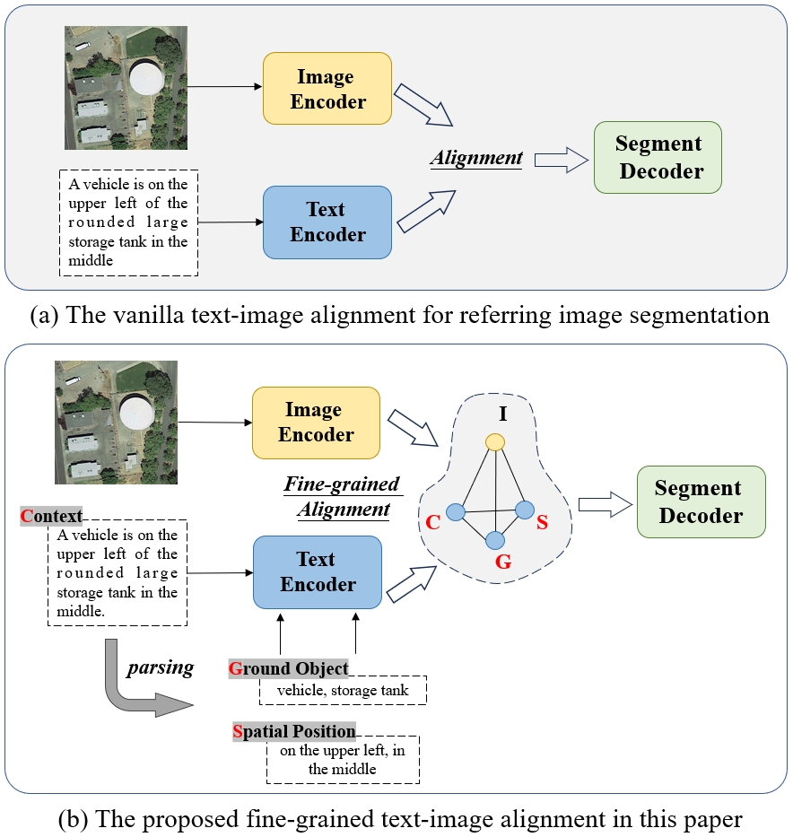
The one of key challenges for this RRSIS task is to learn discriminative multi-modal features via text-image alignment. Previous RRSIS methods [1, 26] typically employed one kind of vanilla and coarse alignment (implicit alignment) of image and text features, as shown in Fig. 1 (a), where the linguistic representation is directly fused with the visual features by leveraging pixel-level attention. This is a concise and direct method, but it neglects the intrinsic information within the referring expression and the fine-grained relationship between the image and the textual description. It might hinder the network from effectively segmentation meeting the complex backgrounds and ground objects with diverse spatial scales in remote sensing.
To handle this issue, we re-examine the vanilla alignment and propose a new paradigm of fine-grained image-text alignment to learn more discriminative multi-modal representations. As illustrated in Fig. 1 (b), the original referring sentence is regarded as a context expression, and it then is parsed into ground object and spatial position. All these sentence fragments will pass the text encoder and obtain fine-grained linguistic representations. By mining the key elements of images and texts, we further establish the fine-grained image-text alignment to construct the subtle association between the image and the referring expression, enabling the model to adaptively focus on relevant areas in remote sensing scenarios.
In this paper, we propose a new referring image segmentation method for remote sensing from the perspective of Fine-grained Image-text Alignment, termed FIANet. Specifically, we design a Fine-grained Image-text Alignment Module (FIAM) to simultaneously leverage the features of the input image and the corresponding text, better discriminative representations across modalities. Meanwhile, to handle the various scales of ground objects in remote sensing, we introduce a Text-aware Multi-scale Enhancement Module (TMEM) to adaptively perform cross-scale fusion and intersections under text guidance. The proposed method is evaluates the effectiveness of the proposed methods on two public referring remote sensing datasets including RefSegRS and RRSIS-D, and it demonstrates that our method obtains superior performance over several state-of-the-art methods.
The main contributions of this paper are summarized as follows:
-
•
We propose a new referring image segmentation method, named FIANet, for remote sensing from the perspective of fine-grained image-text alignment. Compared to the existing approaches, FIANet can fully exploit the subtle association between the visual and linguistic features to learn better discriminative multi-modal representations. Our method obtains state-of-the-art results on two public remote sensing datasets.
-
•
We introduce a fine-grained image-text alignment module to perform the deep intersections between the image and textual expression, which contains context alignment and object-positional alignment. Moreover, we design a text-aware multi-scale alignment module to leverage multi-modal features from different scales with text guidance. This can improve the ability of FIANet to adapt to ground objects with varying and diverse scales. Comprehensive ablation experiments verify the effectiveness of these designs.
The rest parts of this paper are organized as follows. We give a brief description of the background and related work of the referring remote sensing image segmentation in Section II. In Section III, we carefully describe our method and the proposed improvements. Many comparative experiments on two public remote sensing data sets and ablation studies are presented in Section IV. Finally, conclusions are drawn in Section V.
II Background and Related Work
II-A Referring Image Segmentation for Natural Images
Referring image segmentation aims to achieve specific target object segmentation given an image and the corresponding text description of this object, which is a typical multi-modal task and has received growing attention. The pioneering work [16] utilizes a convolutional neural network and recurrent LSTM to capture visual and linguistic representation. Liu [17] proposed a recurrent multimodal interaction model that consists of sequential LSTMs to fulfill word-to-image interaction. Edgar [18] designed a modular neural network that divides the problem of referring image segmentation into many sub-tasks. These methods fuse visual and linguistic representation by simple concatenation to predict pixel-wise segmentation output, which constrains the capability of joint learning of images and languages. The subsequent works [19, 20, 21, 22] mainly focus on the elaborate design of image-text alignment to learn more discriminative multi-modal representations. Ye [19] introduced a cross-modal self-attention module to learn the long-range relationship between the visual and linguistic features, as well as a gated multi-level fusion module to integrate multi-level self-attentive features. Jing [20] leveraged a cross-model interaction module on the multi-modal features by the explicit model of position prior.
Recently, Transformer has exhibited superior performance in the referring image segmentation task [23, 24, 25]. LAVT [23] employs a vision Transformer [27] as the visual encoder and utilizes an early fusion paradigm to perform hierarchical language-aware visual encoding for capturing multi-modal context. Liu [24] designed multi-model mutual attention to better fuse multi-modal information, where the features of inputs are extracted by Swin Transformer and BERT [28], respectively. However, different from natural images, remote sensing imagery usually covers a wide range of ground objects with diverse spatial scales and orientations, which limits the performance of these methods to generate satisfactory segmentation results.
II-B Remote Sensing Referring Image Segmentation and Visual Grounding
In the past year, researchers have begun to pay attention to the field of Referring Remote Sensing Image Segmentation (RRSIS), and two datasets including RefSegRS [1] and RRSIS-D [26] were proposed successively. Yuan [1] tried the first attempt to handle the RRSIS task and proposed a novel Language-Guided Cross-scale Enhancement (LGCE) module to improve the results on small ground objects. Liu [26] introduced a Rotated Multi-Scale Interaction Network (RMSIN) to mitigate the issues caused by diverse spatial scales and orientations in the remote sensing imagery, in which intra-scale and cross-scale interactions are fully excavated.
The Remote Sensing Visual Grounding (RSVG) aims to localize thes ground object with a bounding box referring to the given textual description. Similar to the RRSIS, one of the key challenges for RSVG is to effectively fuse visual and linguistic representations to predict the object’s location. Sun [29] established a new visual ground benchmark dataset for remote sensing and proposed a new model composed of image/language encoders and the corresponding fusion module. Furthermore, Zhan [30] introduced a transformer-based method with multi-level cross-modal feature learning to handle large-scale variations and cluttered backgrounds. More recently, Kuckreja [31] proposed a novel grounded large vision-language model that offered multi-task capacity for high-resolution remote sensing images. This work can handle multiple tasks simultaneously, including visual grounding, image/region caption, scene classification, etc.
III Methodology
III-A Overview of the Proposed Method
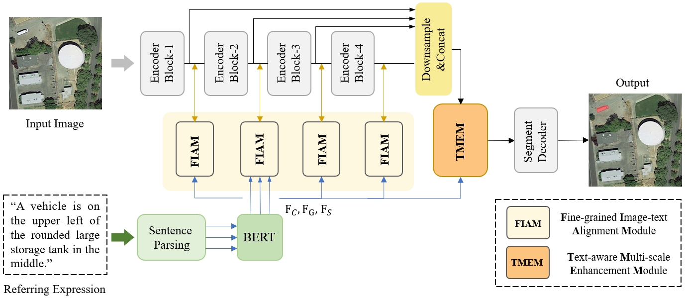
The overview of the proposed FIANet is illustrated in Fig. 2. Similar to the previous architectures [1, 26], the pipeline of FIANet is divided into four procedures: feature extraction, image-text alignment, multi-scale fusion, and segment decoding. Given a remote sensing image and the referring expression , where and denote the height and width of the input image, and represents the length of this sentence.
The visual and linguistic representations are first extracted by an image encoder and a text encoder, respectively, from the image and the paired referring expression. It should be noted that the original textual description will be regarded as context expression and we further decompose the context into two fragments about ground objects and spatial positions. Therefore, there would be three linguistic features in total, including , , and which denote the representations of the original context expression, ground objects, and spatial positions. Specifically, we employ the Natural Language Toolkit (NLTK) [32] to parse the referring expression based on each dataset’s predefined ground object categories. The three linguistic features are extracted by using a pre-trained BERT [33].
The visual hierarchical features from different stages of the encoder are then aligned with these linguistic features to capture better discriminative multi-modal representations. For this point, we propose a Fine-grained Image-text Alignment Module (FIAM) to subtly align visual and linguistic representations. After that, the Text-aware Multi-scale Enhancement Module (TMEM) is implemented to combine these multi-modal representations from different levels, which improves the ability of FIANet to adapt to ground objects with varying and diverse scales Finally, the enhanced multi-scale representations would be integrated to generate the pixel-wise segmentation by the segment decoder. More details about the FIAM and TMEM will be carefully described in the following subsections.
III-B Fine-Grained Image-Text Alignment
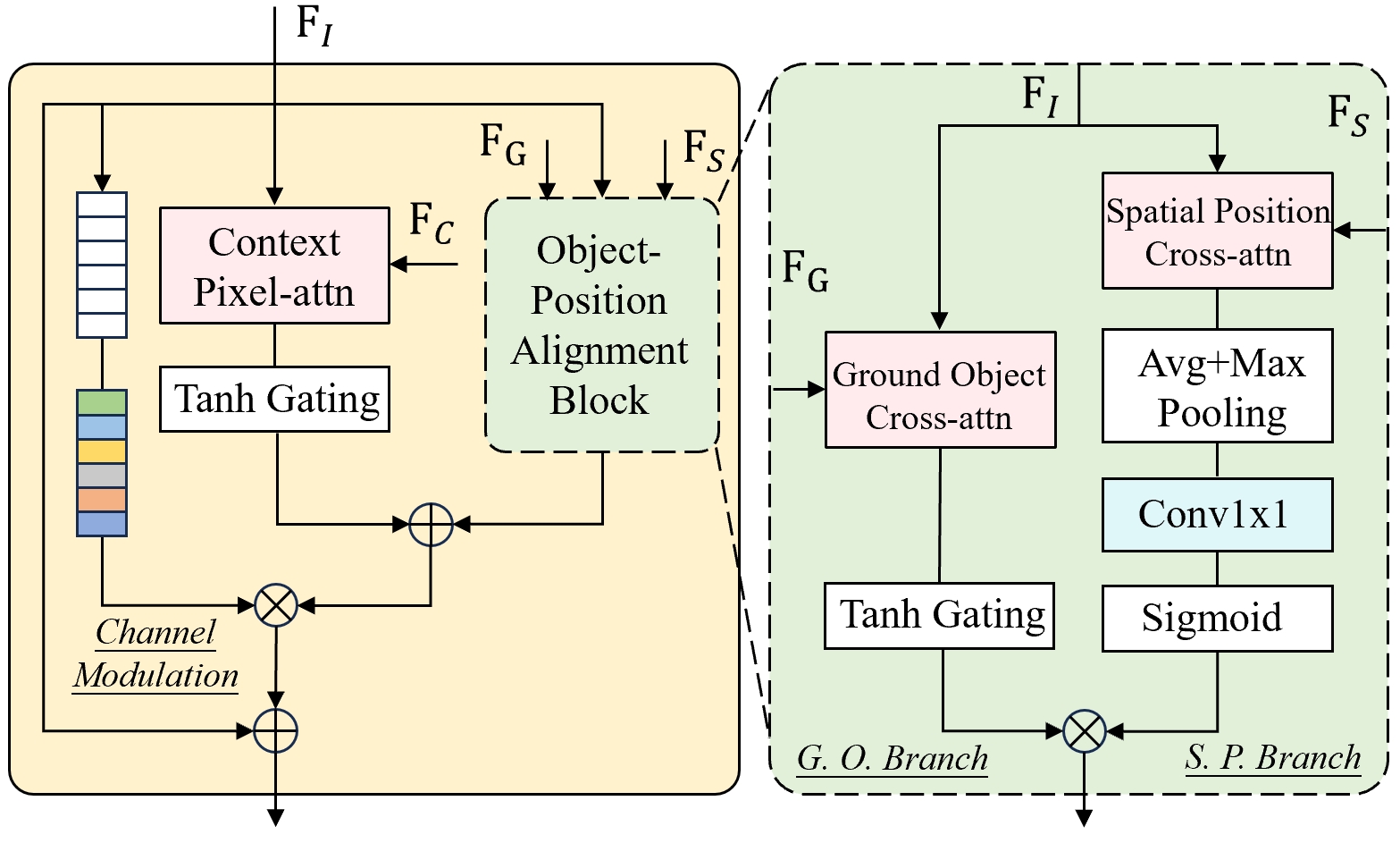
Different from the traditional image-text alignment in the previous method, we introduce a new multi-modal fusion manner from the perspective of fine-grained alignment to capture more discriminative representations. Concretely, we introduce the Fine-grained Image-text Alignment Module (FIAM) to perform the deep intersections between the image and textual expression. The specific structure of FIAM is shown in Fig. 3. Compared to the previous alignment method, the FIAM simultaneously considers visual features , and the linguistic features , and , where these three features denote the representations of the original contextual description, the ground objects, and the spatial position, respectively.
1) Object-Position Alignment Block: For each FIAM, we propose an Object-Position Alignment Block (OPAB) to perform the intersection of features of ground object and spatial position with the visual representation, which is illustrated in the Fig. 3. Specifically, we design a dual-branch structure constructed by a Ground Object Branch and a Spatial Position Branch. The object branch is established to directly perform multi-fusion between the textual features of ground objects and the visual features, which can enhance the discriminative ability of the model on the referent target. The core of the ground object branch is the ground object cross-attention block that can integrate the visual feature and the textual feature . Here, we take the original visual feature as the query, the as the key and value to achieve feature fusion. This implementation can be defined as:
| (1) |
where , and are the linear projection matrices which are responding to the query, key and value, respectively. The is the dimsion of the query.
Moreover, the image-language feature is further modulated by a tanh gate to provide more local details and produce the output for this ground object branch. The calculation can be defined as follows
| (2) |
where the denotes a series of operations, sequentially including linear projection, ReLU activation, linear projection, and Tanh activation.
The spatial position branch is designed to capture the spatial prior guided by the original visual feature and the textual features of positional description . Concretely, the and will go through a cross-attention, where is taken as the query and the is the key and value:
| (3) |
Then the is input into a series of layers to generate spatial attention, where average and maximum pooling, convolution, and sigmoid nonlinearity are implemented. It is shown in Fig.3 and mathematically described as follows
| (4) | ||||
where the is the output of the spatial position branch.
The spatial prior is learned from the spatial position branch, which involves the multi-modal information of visual features and textual features , and it can be better integrated with the ground object features. Then the final output of the OPAB can be acquired by
| (5) |
where denotes element-wise multiplication. The output of OPAB is the fine-alignment features that simultaneously consider the ground object and the corresponding spatial attention, and can help the FGAM to obtain more discriminative representation referring to the specific object.
2) Context Alignment with Visual Features: The integration of the object and position would be an important supplement to the original image-text alignment. In this paper, the original referring expression is regarded as the context expression, which owns more contextual information compared with the sentence fragments of the ground object and spatial position. Given the linguistic context feature and the visual feature , one pixel-attention is employed to combine these two features:
| (6) |
Here, the pixel attention is implemented by the Pixel-Word Attention Module (PWAM)[23], which aligns the visual representations with the language features of the original description. Similar to the ground object cross-attention and spatial position cross-attention, we use the as the query and the as the key and value in the pixel attention. Moreover, the image-language feature is also modulated by a tanh gate. The calculation can be defined as follows
| (7) |
After acquiring the and the , the multi-modal features further be obtained by combining these two:
| (8) |
3) Channel Modulation: In order to encourage the information exchange across channels, we here proposed a channel modulation operator to readjust the extracted multi-modal features which can further enhance the discriminative ability of the proposed method. Specifically, channel-wise dependencies can be obtained by
| (9) |
where the and are learned weights to perform channel shrink and channel expansion, respectively. The denotes the ReLU function and the indicates the sigmoid function.
Then, the channel-weight would be utilized to recalibrate the multi-modal feature to acquire the final output of the FIAM with the original input . The calculation is as follows:
| (10) |
Overall, the is the fine-grained image-text alignment representation, which can fully integrate the visual feature with text features of different levels covering the context, the ground object, and the spatial position. Compared to the current method, the proposed approach can acquire more fine-grained informative features which helps to generate better pixel-level results.
III-C Text-Aware Multi-Scale Enhancement
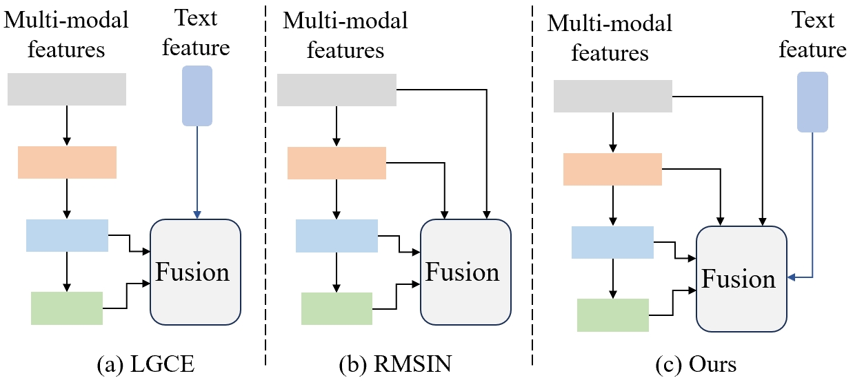
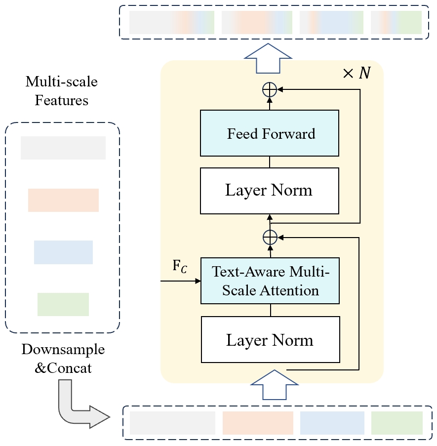
The ground objects in the remote sensing images own vast and diverse scales, hindering the effective extraction of referring objects. Thus cross-scale interaction, which leverages features from different scales, plays an important role in this RRSIS task. As shown in Fig. 4 (a) and Fig. 4 (b), LCGE [1] explores the cross-scale correlation with only two scales assisted by text guidance, and RMSIN [26] employs cross-scale interaction between all the four scales’ features without text guidance. These methods have not fully explored the multi-scale information of visual representations with linguistic features. Drawing inspiration from these methods, we propose a Text-Aware Multi-Scale Enhancement Module (TMEM) to effectively leverage multi-scale visual and linguistic features, where the schematic diagram is shown in Fig. 4 (c). We compare the proposed TMEM with the cross-scale correlation approaches designed in LCGE and RMSIN and verify the superior performance of the TMEM over these two. More detailed information can be found in the next section (Sec. 4.3).
The specific structure of the TMEM is illustrated in Fig. 5. After the fine-grained image-text alignment, it extracts all the multi-modal representations from different stages of the image encoder. Supposing that denotes the output of stage , these features are downsampled with average pooling to the same size and then concatenated along the channel dimension:
| (11) | ||||
where the denotes the downsampled features of and the denotes the concatenated features.
The next question is how to construct a feasible structure of TMEM to achieve the multi-scale feature fusion. For this point, we design a concise and effective structure based on transformer decoders to capture long-term dependencies across different scales. Specifically, the and linguistic feature are fed into TMEM to perform multi-scale fusion. The text-aware multi-scale attention in the TMEM is one kind of multiheaded self-attention (MSA) to perform the deep fusion and intersection with multi-modal features and text guidance. The overall calculation process is as follows:
| (12) | ||||
where the denotes layer normalization [34] and the denotes the multi-layer perceptron which has two layers with GELU nonlinear function [35]. The represents the text-aware multi-scale attention in the TMEM, and the text representation is integrated into the multi-scale fusion to enhance the discriminative ability for referring objects with diverse scales, which can be computed as:
| (13) |
After obtaining the multi-scale enhanced features, the output of TMEM is split along the channel dimension and is upsampled to the original spatial dimension. These enhanced multi-scaled features are passed through a scale-aware gate [26] and a segment decoder to make the final mask prediction.
III-D Implementation Details
In this paper, the proposed method is implemented using Pytorch [36]. Following the setting of [1] and [26], We utilize the Swin Transformer as the visual backbone, which is pre-trained on ImageNet22K [37], and use the BERT from HuggingFace’s Transformer library [38] as the text encoder. The image encoder and text encoder will be fine-tuned on the remote sensing dataset. Referring to the work [26], we use the combination of cross-entropy loss and dice loss to train our model, where the weight of dice loss is set to 0.1.
There are two RRSIS datasets including RefSegRS [1] and RRSIS-D [26], and all the images are resized at pixels. For the RefSegRS and RRSIS-D datasets, we train the model for 60 epochs and 40 epochs, with a learning rate of 5e-5 and 3e-5, respectively. In the training phase, AdamW [39] is adopted to optimize the model, and the weight decay is set to 0.1. All the experiments are conducted on an NVIDIA GeForce RTX 4090 GPU with a batch size of 8.
IV Experiments
| Methods | Publication | Pr@0.5 | Pr@0.6 | Pr@0.7 | Pr@0.8 | Pr@0.9 | oIoU | mIoU |
|---|---|---|---|---|---|---|---|---|
| LSTM-CNN [16] | ECCV’2016 | 15.69 | 10.57 | 5.17 | 1.10 | 0.28 | 53.83 | 24.76 |
| ConvLSTM [40] | CVPR’2018 | 31.21 | 23.39 | 15.30 | 7.59 | 1.10 | 66.12 | 43.34 |
| CMSA [19] | CVPR’2019 | 28.07 | 20.25 | 12.71 | 5.61 | 0.83 | 64.53 | 41.47 |
| BRINet [21] | CVPR’2020 | 22.56 | 15.74 | 9.85 | 3.52 | 0.50 | 60.16 | 32.87 |
| LAVT [23] | CVPR’2022 | 70.23 | 55.53 | 30.05 | 14.42 | 4.07 | 76.21 | 57.30 |
| CrossVLT [41] | TMM’2023 | 71.16 | 58.28 | 34.51 | 16.35 | 5.06 | 77.44 | 58.84 |
| RMISN [26] | CVPR’2024 | 71.60 | 55.97 | 31.87 | 11.72 | 1.93 | 71.73 | 57.78 |
| LGCE [1] | TGRS’2024 | 76.55 | 67.03 | 44.85 | 19.04 | 5.67 | 77.62 | 61.90 |
| FIANet (ours) | — | 84.09 | 77.05 | 61.86 | 33.41 | 7.10 | 78.32 | 68.67 |
| category | LAVT | RMSIN | LGCE | Ours |
|---|---|---|---|---|
| road | 70.33 | 66.67 | 74.03 | 74.13 |
| vehicle | 57.02 | 58.66 | 63.05 | 70.15 |
| car | 55.13 | 57.63 | 60.79 | 68.55 |
| van | 38.55 | 47.09 | 41.60 | 61.06 |
| building | 81.92 | 76.84 | 81.99 | 81.34 |
| truck | 53.07 | 51.92 | 62.69 | 74.48 |
| trailer | 44.56 | 61.65 | 49.82 | 74.92 |
| bus | 52.93 | 60.20 | 45.36 | 72.40 |
| road marking | 5.74 | 18.60 | 6.66 | 22.85 |
| bikeway | 50.26 | 50.35 | 54.23 | 61.16 |
| sidewalk | 57.35 | 49.12 | 61.68 | 62.90 |
| tree | 57.01 | 49.82 | 67.68 | 83.75 |
| low vegetation | 41.08 | 43.73 | 43.68 | 44.84 |
| impervious surface | 81.51 | 76.55 | 83.18 | 81.53 |
| average | 53.32 | 54.92 | 56.89 | 66.72 |
| Methods | Publication | Pr@0.5 | Pr@0.6 | Pr@0.7 | Pr@0.8 | Pr@0.9 | oIoU | mIoU |
|---|---|---|---|---|---|---|---|---|
| RRN [42] | CVPR’2018 | 51.07 | 42.11 | 32.77 | 21.57 | 6.37 | 66.43 | 45.64 |
| CMSA [19] | CVPR’2019 | 55.32 | 46.45 | 37.43 | 25.39 | 8.15 | 69.39 | 48.54 |
| LSCM [43] | ECCV’2020 | 56.02 | 46.25 | 37.70 | 25.28 | 8.27 | 69.05 | 49.92 |
| CMPC [44] | CVPR’2020 | 55.83 | 47.40 | 36.94 | 25.45 | 9.19 | 69.22 | 49.24 |
| BRINet [21] | CVPR’2020 | 56.90 | 48.77 | 39.12 | 27.03 | 8.73 | 69.88 | 49.65 |
| CMPC+ [45] | TPAMI’2021 | 57.65 | 47.51 | 36.97 | 24.33 | 7.78 | 68.64 | 50.24 |
| LAVT [23] | CVPR’2022 | 66.93 | 60.99 | 51.71 | 39.79 | 23.99 | 76.58 | 59.05 |
| CrossVLT [41] | TMM’2023 | 70.38 | 63.83 | 52.86 | 42.11 | 25.02 | 76.32 | 61.00 |
| LGCE [1] | TGRS’2024 | 69.41 | 63.06 | 53.46 | 41.22 | 24.27 | 76.24 | 61.02 |
| RMISN [26] | CVPR’2024 | 71.96 | 65.76 | 55.16 | 42.03 | 25.02 | 76.50 | 62.27 |
| FIANet (ours) | — | 74.46 | 66.96 | 56.31 | 42.83 | 24.13 | 76.91 | 64.01 |
| category | LAVT | RMSIN | LGCE | Ours |
|---|---|---|---|---|
| airport | 66.44 | 68.08 | 68.11 | 68.66 |
| golf field | 56.53 | 56.11 | 56.43 | 57.07 |
| expressway service area | 76.08 | 76.68 | 77.19 | 77.35 |
| baseball field | 68.56 | 66.93 | 70.93 | 70.44 |
| stadium | 81.77 | 83.09 | 84.90 | 84.87 |
| ground track field | 81.84 | 81.91 | 82.54 | 82.00 |
| storage tank | 71.33 | 73.65 | 73.33 | 76.99 |
| basketball court | 70.71 | 72.26 | 74.37 | 74.86 |
| chimney | 65.54 | 68.42 | 68.44 | 68.41 |
| tennis court | 74.98 | 76.68 | 75.63 | 78.48 |
| overpass | 66.17 | 70.14 | 67.67 | 70.01 |
| train station | 57.02 | 62.67 | 58.19 | 61.30 |
| ship | 63.47 | 64.64 | 63.48 | 65.96 |
| expressway toll station | 63.01 | 65.71 | 61.63 | 64.82 |
| dam | 61.61 | 68.70 | 64.54 | 71.31 |
| harbor | 60.05 | 60.40 | 60.47 | 62.03 |
| bridge | 30.48 | 36.74 | 34.24 | 37.94 |
| vehicle | 42.60 | 47.63 | 43.12 | 49.66 |
| windmill | 35.32 | 41.99 | 40.76 | 46.72 |
| average | 62.44 | 65.13 | 64.12 | 66.46 |
IV-A Dataset and Metrics
In the paper, two public remote sensing datasets, including RefSegRS [1] and RRSIS-D [26], are utilized to verify the effectiveness of the proposed method. These datasets were introduced recently, promoting the development of the field of remote sensing referring image segmentation.
-
•
RefSegRS [1]. This dataset contains 4,420 image-text-label triplets in total. The training set has 2,172 triplets, the validation set has 413 triplets, and the rest 1,817 triplets are in the test set. The whole dataset covers 14 categories including road, vehicle, car, van, buliding and etc, with five attribute tags used to describe these ground objects. The image size is and the spatial resolution is 0.13m.
-
•
RRSIS-D [26]. Compared with the RefSegRS, the RRSIS-D is a larger benchmark and comprises a collection of 17,402 images, masks and the referring expressions [26], with 12,181 for training, 1,740 for validation and the rest 3,481 for test. RRSIS-D owns 20 categories for the semantic labels and referring expressions, such as airplane, golf field, expressway service area, baseball field, stadium and etc. The image size of this dataset is with the spatial resolutions ranging from 0.5m to 30m.
Following some earlier works [23, 1, 26], we employ overall Intersection-over-Union (oIoU) and mean Intersection-over-Union (mIoU) to evaluate the overall results of different methods. Specifically, oIoU computes the ratio of the total intersection area to the total union area across the entire test set, thereby giving preference to large ground objects. The mIoU represents the average IoU computed between the predictions and their corresponding ground truths across all test samples, which treats large and small ground objects equally. Moreover, precisions at threshold values of 0.5 to 0.9 (denoted as Pr@X) are also utilized to measure the ratio of test images that pass a specific IoU threshold.
IV-B Comparisons with Other Methods
We compare the proposed method with some state-of-the-art for referring image segmentation on the test sub-sets of the RefSegRS and RRSIS-D datasets. Among these methods, LGCE [1] and RMISN [26] are specifically designed for remote sensing images, and the others are for natural images. The results of different methods are provided in Table I to Table IV. For a fair comparison, we reimplement some state-of-the-art including LAVT [23], CrossVLT [41], LGCE [1], and RMSIN [26], where the total number of train epochs for RefSegRS is set to 60 and the one for RRSIS-D is 40. Meanwhile, for some early published approaches, we take these results reported in LGCE [1] and RMISN [26].
1) Quantitative Results on RefSegRS Dataset. Table I carefully lists the overall results of different methods on the RefSegRS. It can be seen that our proposed method outperforms other methods across all the metrics on this dataset. Particularly, our method obtains gains of 6.77% in mIoU over the second-best LGCE. To further demonstrate the effectiveness of our method, we provide detailed comparisons of the fine-grained categories. The RefSegRS owns 14 kinds of scenes and the referring segmentation results of mean IoU for different categories are shown in Table II. It is obvious that for different ground objects, the outcomes of referring segmentation vary much, where the ”road marking” is hard to segment and the ”impervious surface” is much easier to recognize. In most of these categories, our method can obtain higher mIoU values than LGCE, RMSIN, and LAVT. Moreover, the average mIoU of the proposed method is much higher than the other three methods. This verifies the effectiveness of our method for diverse ground objects.
2) Quantitative Results on RRSIS-D Dataset. Compared to the RefSegRS Dataset, RRSIS-D is a larger dataset with 20 categories of ground objects, and more training samples are leveraged to optimize these models. The overall results are presented in Table III. Likewise, our method achieves the best performance on this dataset in terms of mIoU, oIoU, and from Pr@0.5 to Pr@0.8. Specifically, the proposed method obtains gains of 1.74% in mIoU over the second-best RMSIN. Meanwhile, we have calculated the segmentation results for each category and provide these in Table IV. Compared to the RefSegRS, the ground objects in the RRSIS-D dataset are more intricate to identify with diverse and varying scales. Our method obtains the best performance on the most ground objects, including road, vehicle, car, van and etc., and achieves the highest average mIoU with 1.33% higher than the second-best RMSIN.
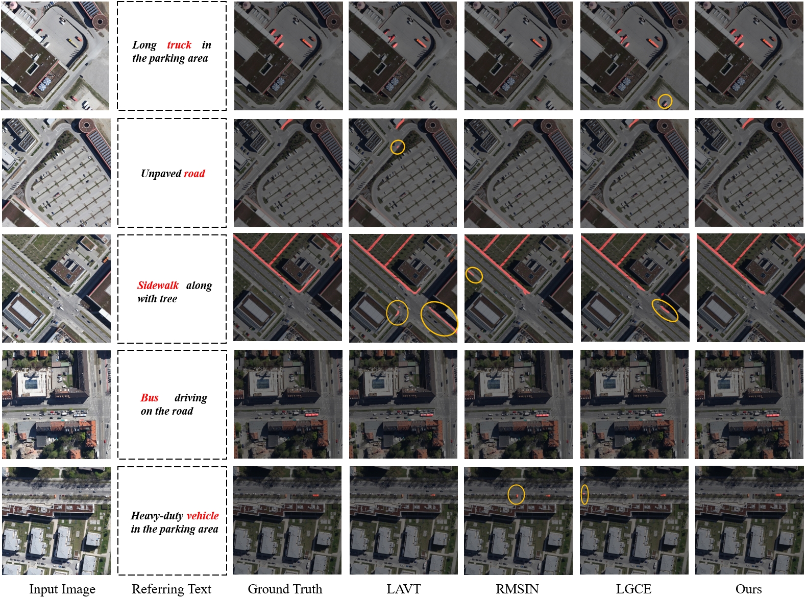
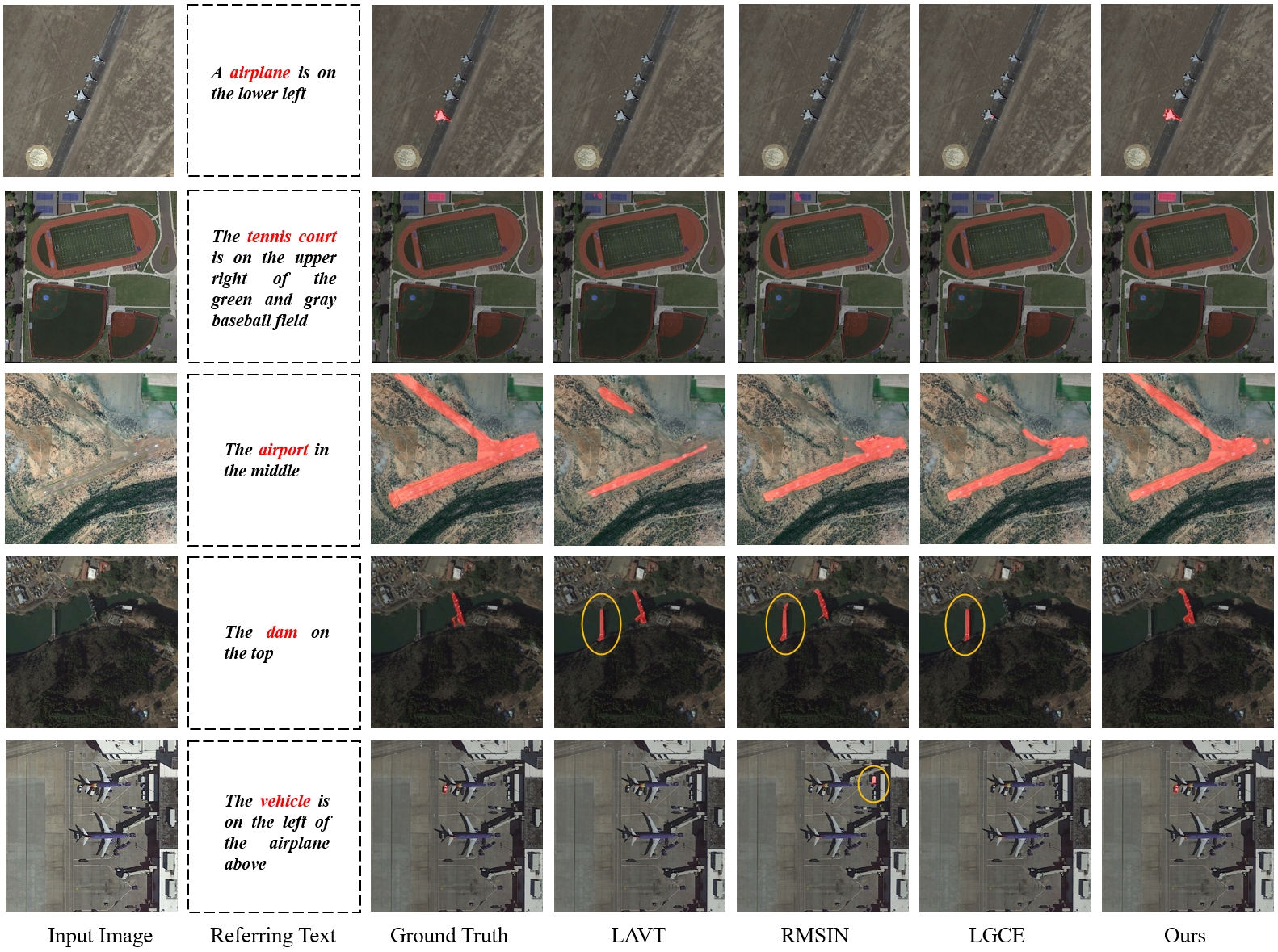
3) Qualitative Comparisons. We here provide some qualitative comparisons with LAVT, RMSIN, and LGCE on these two datasets. Fig. 6 shows several segmentation results referring to the corresponding texts of the RefSegRS dataset, including truck, road, sidewalk, bus, and vehicle scenes which are marked in red. Moreover, Fig. 7 illustrates the outcomes of RRSIS-D dataset covering several ground objects such as airplane, tennis court, airport, dam and vehicle. Some false alarms of different methods are circled in yellow. Compared with other methods, our method can generate more accurate pixel-wise predictions across various scales for different ground objects. Meanwhile, our method can obtain more precise ground object locations and produce fewer false alarms. These visual comparisons demonstrate the robustness of the proposed method on different ground objects and diverse scales covering tiny vehicles, medium dams and large airports.
IV-C Ablation Studies
We have conducted a series of ablation experiments on the test subset of RefSeg dataset to verify the effectiveness of core components within our method.
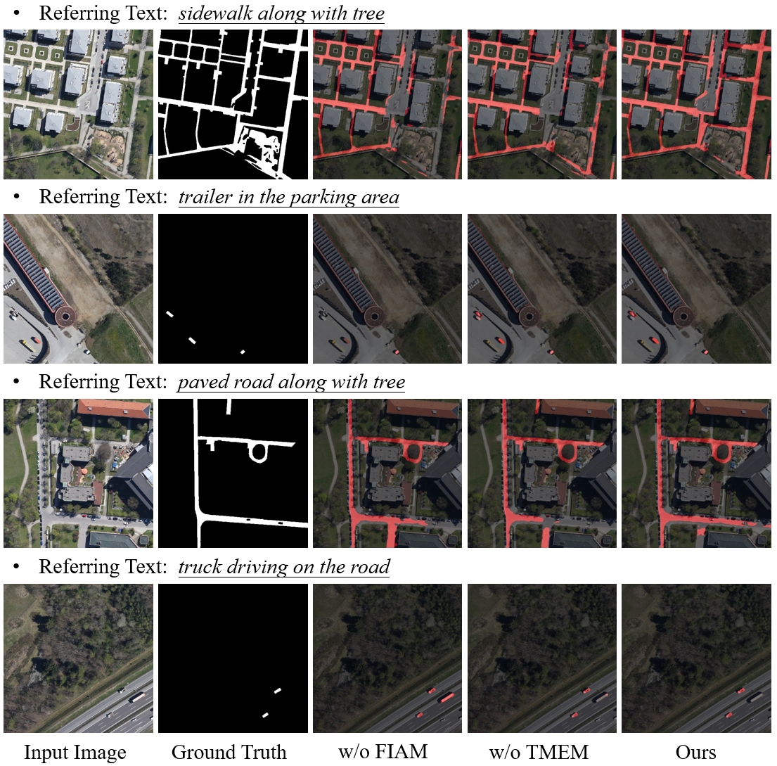
1) Effectiveness of FIAM and TMEM. We design some experiments to assess the importance of FIAM and TMEM, and the results are listed in Table V. The baseline without FIAM and TMEM leverages a traditional image-text alignment used in LAVT. As shown in Table V, the introduction of FIAM can largely improve the segmentation results, where mIoU obtains an increase of 4.44%. The combination of the TMEM can further promote the performance of the proposed method. In order to further demonstrate the effectiveness of these two modules, we visually compare the segmentation maps on the test subset of RefSegRS dataset, which are shown in Fig .8. From these results, the proposed method with FIAM and TMEM achieves better performance and segmentation results.
| FIAM | TMEM | P@0.5 | P@0.7 | P@0.9 | oIoU | mIoU |
|---|---|---|---|---|---|---|
| 78.37 | 43.04 | 2.86 | 74.90 | 62.24 | ||
| ✓ | 83.21 | 57.29 | 4.79 | 77.83 | 66.68 | |
| ✓ | 80.96 | 53.99 | 4.29 | 75.62 | 65.39 | |
| ✓ | ✓ | 84.09 | 61.86 | 7.10 | 78.32 | 68.67 |
2) Effect of different designs of FIAM. In order to provide an in-depth understanding of FIAM, we carry out some experiments to explore the effect of different designs of FGAM. For this point, we remove some key components of this module to record the change in metrics. As provided in Table VI, we explore the influences of channel modulation (C.M.), ground object branch (G.O.B), and spatial positional branch (S.P.B). It is obvious that through the integration of these components, the proposed method obtains better performance. Furthermore, this verifies the effectiveness of the fine-grain image-text alignment.
| C.M. | G.O.B. | S.P.B. | P@0.5 | P@0.7 | P@0.9 | oIoU | mIoU |
|---|---|---|---|---|---|---|---|
| 80.96 | 53.99 | 4.29 | 75.62 | 65.39 | |||
| ✓ | 81.40 | 53.99 | 4.73 | 76.07 | 65.76 | ||
| ✓ | ✓ | 83.27 | 57.46 | 5.34 | 77.40 | 67.01 | |
| ✓ | ✓ | ✓ | 84.09 | 61.86 | 7.10 | 78.32 | 68.67 |
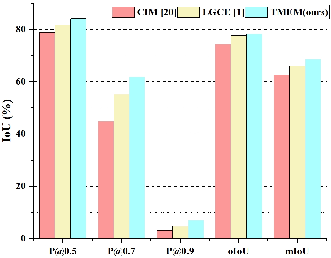
3) Effect of different designs of multi-scale fusion. To further demonstrate the efficacy of the proposed TMEM, we here use the other two designs of multi-scale fusion to be comparisons, i.e., Cross Intersection Module (CIM) [26] and Language-Guided Cross-scale Enhancement (LGCE) [1]. We use the CIM or LGCE to replace the TMEM and the other designs remain the same. From Fig. 9, we can see that the proposed TMEM outperforms the CIM and LGCE across all the metrics. This demonstrates the importance of the referring text in the multi-scale feature enhancement and effectiveness of the proposed TMEM.
V Conclusions
In this paper, we propose a new referring image segmentation method for remote sensing, named FIANet, from the perspective of fine-grained image-text alignment. Specifically, we design a Fine-grained Image-text Alignment Module (FIAM) to exploit the subtle association between the visual and linguistic features and learn better discriminative multi-modal representations. Moreover, to handle the various scales of ground objects in remote sensing, we introduce a Text-aware Multi-scale Enhancement Module (TMEM) to adaptively perform cross-scale fusion and intersections under text guidance. We evaluate the effectiveness of the proposed methods on two public referring remote sensing datasets including RefSegRS and RRSIS-D, demonstrating that our method can obtain superior performance over several state-of-the-art methods. Meanwhile, comprehensive ablation experiments also verify the effectiveness of FIAM and TMEM.
References
- [1] Z. Yuan, L. Mou, Y. Hua, and X. X. Zhu, “Rrsis: Referring remote sensing image segmentation,” IEEE Transactions on Geoscience and Remote Sensing, 2024.
- [2] X. Yuan, J. Shi, and L. Gu, “A review of deep learning methods for semantic segmentation of remote sensing imagery,” Expert Systems with Applications, vol. 169, p. 114417, 2021.
- [3] S. Lei and Z. Shi, “Hybrid-scale self-similarity exploitation for remote sensing image super-resolution,” IEEE Transactions on Geoscience and Remote Sensing, vol. 60, pp. 1–10, 2021.
- [4] S. Lei, Z. Shi, and W. Mo, “Transformer-based multi-stage enhancement for remote sensing image super-resolution,” IEEE Transactions on Geoscience and Remote Sensing, 2021.
- [5] C. Qiu, X. Zhang, X. Tong, N. Guan, X. Yi, K. Yang, J. Zhu, and A. Yu, “Few-shot remote sensing image scene classification: Recent advances, new baselines, and future trends,” ISPRS Journal of Photogrammetry and Remote Sensing, vol. 209, pp. 368–382, 2024.
- [6] F. Tian, S. Lei, Y. Zhou, J. Cheng, G. Liang, Z. Zou, H.-C. Li, and Z. Shi, “Hirenet: Hierarchical-relation network for few-shot remote sensing image scene classification,” IEEE Transactions on Geoscience and Remote Sensing, 2024.
- [7] X. Xiao, L. Wang, K. Ding, S. Xiang, and C. Pan, “Deep hierarchical encoder-decoder network for image captioning,” IEEE Transactions on Multimedia, vol. 21, no. 11, pp. 2942–2956, 2019.
- [8] X. Xiao, L. Wang, S. Xiang, and C. Pan, “What and where the themes dominate in image,” in The Thirty-Third AAAI Conference on Artificial Intelligence, (AAAI). AAAI Press, 2019, pp. 9021–9029.
- [9] X. Xiao, L. Wang, K. Ding, S. Xiang, and C. Pan, “Dense semantic embedding network for image captioning,” Pattern Recognit., vol. 90, pp. 285–296, 2019.
- [10] S. Gui, S. Song, R. Qin, and Y. Tang, “Remote sensing object detection in the deep learning era—a review,” Remote Sensing, vol. 16, no. 2, p. 327, 2024.
- [11] J. Zhu, J. Zhang, H. Chen, Y. Xie, H. Gu, and H. Lian, “A cross-view intelligent person search method based on multi-feature constraints,” International Journal of Digital Earth, vol. 17, no. 1, p. 2346259, 2024.
- [12] Z. Zheng, Y. Zhong, J. Wang, A. Ma, and L. Zhang, “Farseg++: Foreground-aware relation network for geospatial object segmentation in high spatial resolution remote sensing imagery,” IEEE Transactions on Pattern Analysis and Machine Intelligence, 2023.
- [13] S. Cao, D. Feng, S. Liu, W. Xu, H. Chen, Y. Xie, H. Zhang, S. Pirasteh, and J. Zhu, “Bemrf-net: Boundary enhancement and multiscale refinement fusion for building extraction from remote sensing imagery,” IEEE Journal of Selected Topics in Applied Earth Observations and Remote Sensing, 2024.
- [14] Y.-C. Li, S. Lei, N. Liu, H.-C. Li, and Q. Du, “Ida-siamnet: Interactive-and dynamic-aware siamese network for building change detection,” IEEE Transactions on Geoscience and Remote Sensing, 2024.
- [15] Y. Xie, N. Zhan, J. Zhu, B. Xu, H. Chen, W. Mao, X. Luo, and Y. Hu, “Landslide extraction from aerial imagery considering context association characteristics,” International Journal of Applied Earth Observation and Geoinformation, vol. 131, p. 103950, 2024.
- [16] R. Hu, M. Rohrbach, and T. Darrell, “Segmentation from natural language expressions,” in Proceedings of the European Conference on Computer Vision (ECCV). Springer, 2016, pp. 108–124.
- [17] C. Liu, Z. Lin, X. Shen, J. Yang, X. Lu, and A. Yuille, “Recurrent multimodal interaction for referring image segmentation,” in Proceedings of the IEEE international conference on computer vision, 2017, pp. 1271–1280.
- [18] E. Margffoy-Tuay, J. C. Pérez, E. Botero, and P. Arbeláez, “Dynamic multimodal instance segmentation guided by natural language queries,” in Proceedings of the European Conference on Computer Vision (ECCV), 2018, pp. 630–645.
- [19] L. Ye, M. Rochan, Z. Liu, and Y. Wang, “Cross-modal self-attention network for referring image segmentation,” in Proceedings of the IEEE/CVF conference on computer vision and pattern recognition, 2019, pp. 10 502–10 511.
- [20] Y. Jing, T. Kong, W. Wang, L. Wang, L. Li, and T. Tan, “Locate then segment: A strong pipeline for referring image segmentation,” in Proceedings of the IEEE/CVF Conference on Computer Vision and Pattern Recognition, 2021, pp. 9858–9867.
- [21] Z. Hu, G. Feng, J. Sun, L. Zhang, and H. Lu, “Bi-directional relationship inferring network for referring image segmentation,” in Proceedings of the IEEE/CVF conference on computer vision and pattern recognition, 2020, pp. 4424–4433.
- [22] H. Shi, H. Li, F. Meng, and Q. Wu, “Key-word-aware network for referring expression image segmentation,” in Proceedings of the European Conference on Computer Vision (ECCV), 2018, pp. 38–54.
- [23] Z. Yang, J. Wang, Y. Tang, K. Chen, H. Zhao, and P. H. Torr, “Lavt: Language-aware vision transformer for referring image segmentation,” in Proceedings of the IEEE/CVF Conference on Computer Vision and Pattern Recognition, 2022, pp. 18 155–18 165.
- [24] C. Liu, H. Ding, Y. Zhang, and X. Jiang, “Multi-modal mutual attention and iterative interaction for referring image segmentation,” IEEE Transactions on Image Processing, vol. 32, pp. 3054–3065, 2023.
- [25] N. Kim, D. Kim, C. Lan, W. Zeng, and S. Kwak, “Restr: Convolution-free referring image segmentation using transformers,” in Proceedings of the IEEE/CVF Conference on Computer Vision and Pattern Recognition, 2022, pp. 18 145–18 154.
- [26] S. Liu, Y. Ma, X. Zhang, H. Wang, J. Ji, X. Sun, and R. Ji, “Rotated multi-scale interaction network for referring remote sensing image segmentation,” in Proceedings of the IEEE/CVF Conference on Computer Vision and Pattern Recognition, 2024, pp. 26 658–26 668.
- [27] Z. Liu, Y. Lin, Y. Cao, H. Hu, Y. Wei, Z. Zhang, S. Lin, and B. Guo, “Swin transformer: Hierarchical vision transformer using shifted windows,” in Proceedings of the IEEE/CVF international conference on computer vision, 2021, pp. 10 012–10 022.
- [28] A. Vaswani, N. Shazeer, N. Parmar, J. Uszkoreit, L. Jones, A. N. Gomez, Ł. Kaiser, and I. Polosukhin, “Attention is all you need,” Advances in neural information processing systems, vol. 30, 2017.
- [29] Y. Sun, S. Feng, X. Li, Y. Ye, J. Kang, and X. Huang, “Visual grounding in remote sensing images,” in Proceedings of the 30th ACM International Conference on Multimedia, 2022, pp. 404–412.
- [30] Y. Zhan, Z. Xiong, and Y. Yuan, “Rsvg: Exploring data and models for visual grounding on remote sensing data,” IEEE Transactions on Geoscience and Remote Sensing, vol. 61, pp. 1–13, 2023.
- [31] K. Kuckreja, M. S. Danish, M. Naseer, A. Das, S. Khan, and F. S. Khan, “Geochat: Grounded large vision-language model for remote sensing,” in Proceedings of the IEEE/CVF Conference on Computer Vision and Pattern Recognition, 2024, pp. 27 831–27 840.
- [32] E. Loper and S. Bird, “Nltk: The natural language toolkit,” arXiv preprint cs/0205028, 2002.
- [33] J. Devlin, “Bert: Pre-training of deep bidirectional transformers for language understanding,” arXiv preprint arXiv:1810.04805, 2018.
- [34] J. L. Ba, J. R. Kiros, and G. E. Hinton, “Layer normalization,” arXiv preprint arXiv:1607.06450, 2016.
- [35] D. Hendrycks and K. Gimpel, “Gaussian error linear units (gelus),” arXiv preprint arXiv:1606.08415, 2016.
- [36] A. Paszke, S. Gross, F. Massa, A. Lerer, J. Bradbury, G. Chanan, T. Killeen, Z. Lin, N. Gimelshein, L. Antiga et al., “Pytorch: An imperative style, high-performance deep learning library,” Advances in neural information processing systems, vol. 32, 2019.
- [37] J. Deng, W. Dong, R. Socher, L.-J. Li, K. Li, and L. Fei-Fei, “Imagenet: A large-scale hierarchical image database,” in 2009 IEEE conference on computer vision and pattern recognition. Ieee, 2009, pp. 248–255.
- [38] T. Wolf, L. Debut, V. Sanh, J. Chaumond, C. Delangue, A. Moi, P. Cistac, T. Rault, R. Louf, M. Funtowicz et al., “Transformers: State-of-the-art natural language processing,” in Proceedings of the 2020 conference on empirical methods in natural language processing: system demonstrations, 2020, pp. 38–45.
- [39] I. Loshchilov and F. Hutter, “Decoupled weight decay regularization,” arXiv preprint arXiv:1711.05101, 2017.
- [40] R. Li, K. Li, Y.-C. Kuo, M. Shu, X. Qi, X. Shen, and J. Jia, “Referring image segmentation via recurrent refinement networks,” in Proceedings of the IEEE Conference on Computer Vision and Pattern Recognition, 2018, pp. 5745–5753.
- [41] Y. Cho, H. Yu, and S.-J. Kang, “Cross-aware early fusion with stage-divided vision and language transformer encoders for referring image segmentation,” IEEE Transactions on Multimedia, 2023.
- [42] R. Li, K. Li, Y.-C. Kuo, M. Shu, X. Qi, X. Shen, and J. Jia, “Referring image segmentation via recurrent refinement networks,” in Proceedings of the IEEE Conference on Computer Vision and Pattern Recognition, 2018, pp. 5745–5753.
- [43] T. Hui, S. Liu, S. Huang, G. Li, S. Yu, F. Zhang, and J. Han, “Linguistic structure guided context modeling for referring image segmentation,” in Proceedings of the European Conference on Computer Vision (ECCV). Springer, 2020, pp. 59–75.
- [44] S. Huang, T. Hui, S. Liu, G. Li, Y. Wei, J. Han, L. Liu, and B. Li, “Referring image segmentation via cross-modal progressive comprehension,” in Proceedings of the IEEE/CVF conference on computer vision and pattern recognition, 2020, pp. 10 488–10 497.
- [45] S. Liu, T. Hui, S. Huang, Y. Wei, B. Li, and G. Li, “Cross-modal progressive comprehension for referring segmentation,” IEEE Transactions on Pattern Analysis and Machine Intelligence, vol. 44, no. 9, pp. 4761–4775, 2021.