GPT4GEO: How a Language Model
Sees the World’s Geography
Abstract
Large language models (LLMs) have shown remarkable capabilities across a broad range of tasks involving question answering and the generation of coherent text and code. Comprehensively understanding the strengths and weaknesses of LLMs is beneficial for safety, downstream applications and improving performance. In this work, we investigate the degree to which GPT-4 has acquired factual geographic knowledge and is capable of using this knowledge for interpretative reasoning, which is especially important for applications that involve geographic data, such as geospatial analysis, supply chain management, and disaster response. To this end, we design and conduct a series of diverse experiments, starting from factual tasks such as location, distance and elevation estimation to more complex questions such as generating country outlines and travel networks, route finding under constraints and supply chain analysis. We provide a broad characterisation of what GPT-4 (without plugins or Internet access) knows about the world, highlighting both potentially surprising capabilities but also limitations.
1 Introduction
In recent years, large language models (LLMs), such as the Generative Pre-trained Transformer (GPT) series [1, 2, 3, 4], LLaMA [5], PaLM [6], and BLOOM [7], have demonstrated remarkable capabilities in understanding and generating natural language text across a broad range of tasks. The recently released GPT-4 [4] model displays a broad range of skills, arguably significantly beyond those of its predecessors and contemporaries alike, opening up new avenues for application in both commercial and scientific domains.
Despite only being publicly released less than two months ago, numerous studies have been carried out revealing the ability of GPT-4 to perform a diverse set of tasks such as generating artwork, writing code [8], search [9], recipe generation [10], mathematics [11] and architecture optimisation [12], as well as achieve strong performance on many examinations [4, 13]. However, there is yet to be a detailed investigation into what the model knows about the world’s geography.
A comprehensive understanding of the geographic capabilities of GPT-4 is important for: (1) Safety. As AI models become more powerful, so do the potential dangers and safety risks [14]. An awareness of the full range of the acquired knowledge and skills of GPT-4 is essential to safe, widespread deployment in society. Similarly, an understanding of when the model hallucinates [15] is critical to safe and reliable usage. (2) Improvements. Accurate knowledge of cases where GPT-4 succeeds and fails are vital to drive research in model training and architecture. (3) Downstream applications. Only after a reasonable understanding of GPT-4’s abilities is it possible to maximally leverage it for downstream tasks, applications and products. Strong geographic knowledge and skills would enable many commercial opportunities in the travel and navigation sectors as well as boost research, for example in environmental sciences.

Despite these compelling incentives, actually characterising the capabilities of GPT-4, even in a specific domain, is challenging for a number of reasons: (i) Closed source. Only limited technical details of the GPT-4 model have been publicly released, making it difficult to estimate capabilities via scaling laws. (ii) Training volume. It is highly likely GPT-4 was trained on a very large-scale text corpus. Even if details of this data were available, given the scale, it would be challenging to fully understand the distribution of content and correspondingly infer specifics about the knowledge acquired by the model. (iii) Breadth of capability. As models become more generalised, the range of possible tasks they can perform greatly increases. (vi) Combinatorial explosion. The scale of the diversity of the world’s geography means that attaining a comprehensive understanding of even a subset of geographic capability requires experimentation across many different factors, quickly resulting in an unfeasible number of permutations [16].
In this work, we provide a broad profile of what GPT-4 knows about the world. To overcome the challenges of characterising the capability of an LLM like GPT-4, we design experiments of varying degrees of depth, providing a mixture of both qualitative and quantitative results. We initially probe low-level descriptive knowledge before transitioning towards more complex, application-centric geographic tasks that build upon the factual knowledge and incorporate it into logical answers.
2 Related Work
GPT-4 capabilities.
Recent works have characterised GPT-4’s ability to solve tasks within a narrow focus. In the computer science domain, GPT-4 has been tasked with coding [17], information retrieval [9], spear phishing [18], and neural architecture search [12]. Many works have explored the performance of GPT-4 in the medical domain [19, 20, 21, 22, 23]. Other areas investigated include mathematics [11], education [24] and literature [25, 26], as well as receipe generation [10], climate science [27] and logical reasoning [28]. More generalised profiles of GPT-4’s capability are provided by OpenAI’s technical report [4] and [8], from which we draw inspiration. In [4], numerous test scores are reported, including the AP Environmental Science exam, in which GPT-4 scores in the 91st percentile. This encompasses a small amount of geographical awareness combined with environmental knowledge but covers entirely different question types to our experiments. Concurrent work [29] creates a prototype system using GPT-4 as the reasoning core of an autonomous geospatial agent; however, system design is central to this work and geographic capability is only peripherally probed. Our work focuses on providing a broad profile of what GPT-4 knows about the world.
Geographic capabilities of other language models.
Cultural commonsense knowledge research indirectly covers geographic knowledge, with the focus being evaluating the cultural knowledge of language models, such as GPT-3 [30] or other multilingual models [31]. Query point-of-interest matching is more directly related to geography with a focus on location. Pretraining language models with geographic context [32, 33] results in relatively strong performances in various location-based geographic tasks. Leveraging the superior capabilities of GPT-4, our work includes these tasks as a subset of a wide selection of geographic knowledge capability characterisation.
3 Method
3.1 GPT-4
We use the GPT-4 model [4] in all of our experimentation. Citing competitive and safety considerations, OpenAI has not released technical details for GPT-4. However, it is likely GPT-4 follows (in some form) the same 2-stage training strategy of previous models: (1) Training. Next word prediction training from a large corpus of text taken from the Internet. (2) Fine-tuning. Fine-tuning via Reinforcement Learning from Human Feedback. For this work, we interact with GPT-4 using three methods: the ChatGPT interface111https://chat.openai.com, the OpenAI Playground222https://platform.openai.com and API333https://platform.openai.com/docs/api-reference, using the default settings.
For each experiment, we provide an used to query GPT-4, and include details of our experimental setup, ground-truth data and specific prompts in the Appendix. For each experiment we generate all responses from the same GPT-4 instance, and unless otherwise stated, we use outputs from single prompts. For a discussion of reproducibility see Sec. 5.
3.2 Experimental Design
To characterise what GPT-4 knows about the world, we devise a set of progressively more challenging experiments that aim to provide a broad profile of capabilities across key geographic aspects. Due to the breadth and complexity of the world’s geography, coupled with GPT-4’s stochasticity, we curate a representative set of quantitative and qualitative experiments, see Fig. 1.
Descriptive. We begin with low-level tasks probing factual knowledge that is essential for downstream applications. We arrange these tasks according to increasing difficulty, progressing from simple estimations toward more complex topography and mapping.
Application-centric. Building on the prior experiments, we investigate GPT-4’s ability to leverage the acquired descriptive knowledge for application-centric reasoning tasks. We extensively explore travel and navigation, as well as, supply chains, networks, wildlife ranges and many more.
Evaluation. We use a range of data sources to determine either qualitatively or quantitatively (depending on the nature of each experiment) the degree to which GPT-4 is correct. For geospatial experiments, we frequently leverage the Cartopy library444https://scitools.org.uk/cartopy/ and Google Maps as a source of ground truth. For the quantiative experiments, we report the relative error555, where and are the true and predicted values..
4 Experiments
4.1 Descriptive
We initially investigate GPT-4’s ability to solve descriptive tasks by conducting simple spatial and human knowledge retrieval experiments. Next, we increase the complexity and explore more challenging tasks that require additional reasoning. Finally, we discuss our findings.
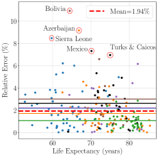
Population, life expectancy and CO2 emissions. We evaluate GPT-4’s understanding of country-level socioeconomic indicators – i.e., population, life expectancy and CO2 emissions – by calculating the relative error against ground-truth data from [34], [35] and [36], respectively (see Fig. 2). For populations, GPT-4 performs relatively well with a mean relative error (MRE) of 3.61%. However, significantly higher errors are recorded for less populated countries. For country life expectancies, GPT-4 performs even better, with an MRE 2% and a worst error of just over 10%. GPT-4’s estimations for CO2 emissions per capita are an order of magnitude worse with an MRE of 20% and individual errors of 150% for two countries. We observe minor variations in MRE across continents for each experiment, however, there is no consistent overall trend. We use the same format of prompt for each experiment, e.g., for population:
Where we obtain <Country_Names> from the respective ground truths.


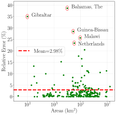
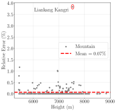
Area and height. We evalute GPT-4’s knowledge of country areas and heights of the 300 tallest mountains by calculating the relative error against ground-truth data from [37] and [38], respectively – see Figs. 3(a)-3(b). For country areas, GPT-4 attains an MRE of 3% with reasonable spread in accuracy, and relative errors of 20% for 6 countries. Very strong performance is shown for the mountain heights, with an MRE of 0.07% and only one outlying error at 4%. We prompt GPT-4 for areas and heights in the same way as the socioeconomic indicators, e.g., for areas:
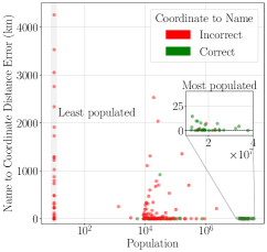
Location. We compile a set of the 30 most and least populated settlements, as well as a representative sample of 100 settlements with populations distributed in between (all data is taken from [39]). We conduct two experiments, the results for which are displayed in Fig. 3(c). First, we provide the settlement names to GPT-4, asking for the coordinates of each and we calculate the distance error to the true coordinates using the haversine formula. We observe the location accuracy clearly decreases with decreasing settlement population, with the worst case out by 4,000 km. Next, we conduct the reverse – providing the coordinates to GPT-4 and asking for the names. This proves much more difficult, with incorrect settlement names predicted in most cases (red points). For the Name Coordinates setting, we query GPT-4 using the following prompt (and use the reverse for Coordinate Name setting):
Distance. We obtain coordinates and population of cities from the GeoNames databases [40]. We randomly sample 40 city pairs from each continent and population group and ask GPT-4 to estimate the corresponding distances. We calculate the relative error between the prediction and ground truth distances using the haversine formula from the coordinates. We used the following prompt for distance estimation. In cases where the number of outputs did not match the number of provided cities, we repeated the prompt.
Our results (Tab. 1) indicate mediocre performance for distance estimation. Average errors can exceed 50% for small cities but are generally lower for larger populations. A limiting factor for these experiments is that the selection of cities influences the error substantially. For a different sample of city pairs in Europe we obtained an average error of 22.8 , for reference randomly shuffling the ground truth distances in this setting results in a relative error of 152 %.
| Continent | Population | |||
|---|---|---|---|---|
| 20K | 100K | 500K () | 500K | |
| Europe | 17.2* | 19.3 | 12.4 * | 14.2 |
| North America | 51.0 | 51.7 | 11.1 | 12.6 |
| South America | 32.0 | 44.5 | 28.6 * | 20.4 |
| Asia | 33.7 | 27.3 | 24.8 | 18.3 |
| Africa | 33.4 | 25.9 | 23.5 | 18.3 |
| Oceania | 21.1* | 25.7* | 12.4 * | 0.6* |
| * changed prompt since ChatGPT became reluctant to provide distances (possibly due to an updated configuration). |
| denotes standard deviation over five runs. |
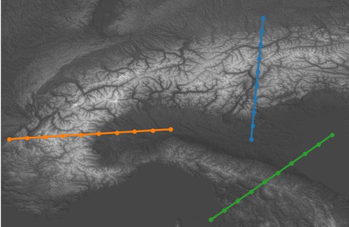
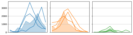
Topography. We qualitatively assess GPT-4’s topographical knowledge by considering three straight line trajectories (w.r.t. the geographic coordinate system) in the Alps and northern Italy. We simultaneously prompt for the elevation at ten equidistant points along each trajectory (Fig. 4, each prompt is repeated three times). To obtain ground truth, we use the ESA Copernicus Digital Elevation Model [41]. We build a geo-referenced elevation map that is sampled at the coordinates along the three trajectories. These coordinates are directly used as an input for GPT-4 using the following prompt:
The results indicate that GPT-4 has acquired a good sense of the elevation in this region of the world. However, it does not generate highly accurate predictions and tends to be sensitive to prompting (see Appendix).
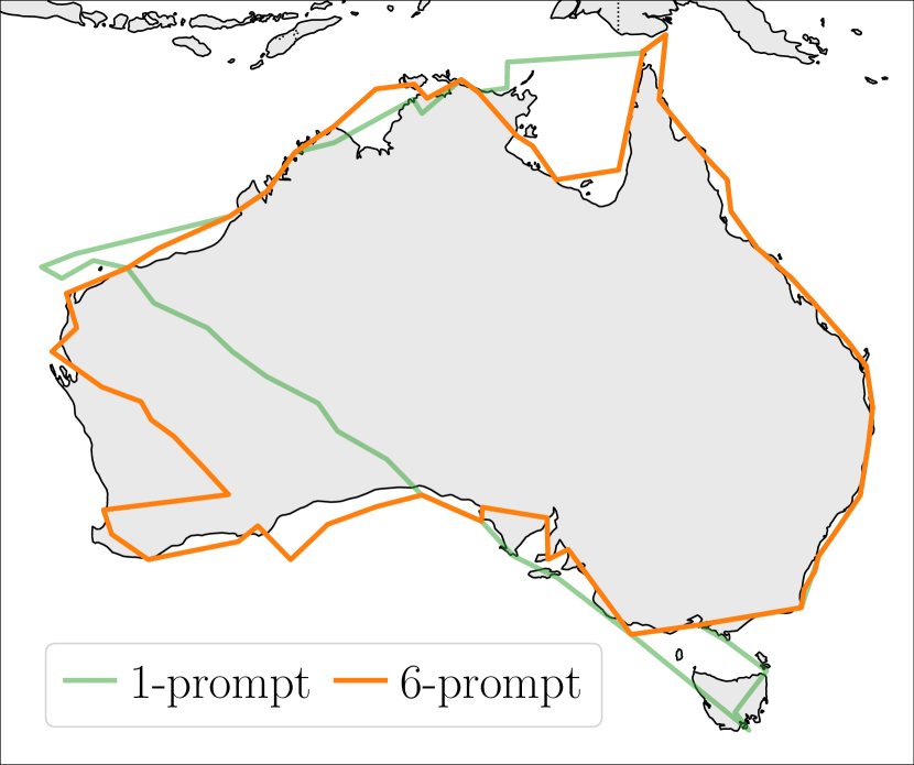
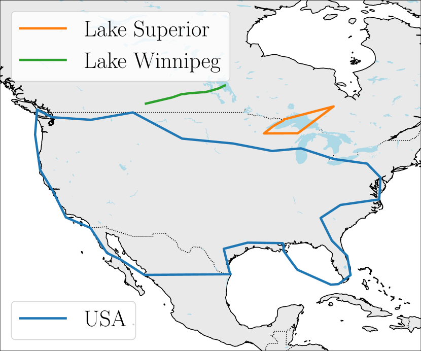
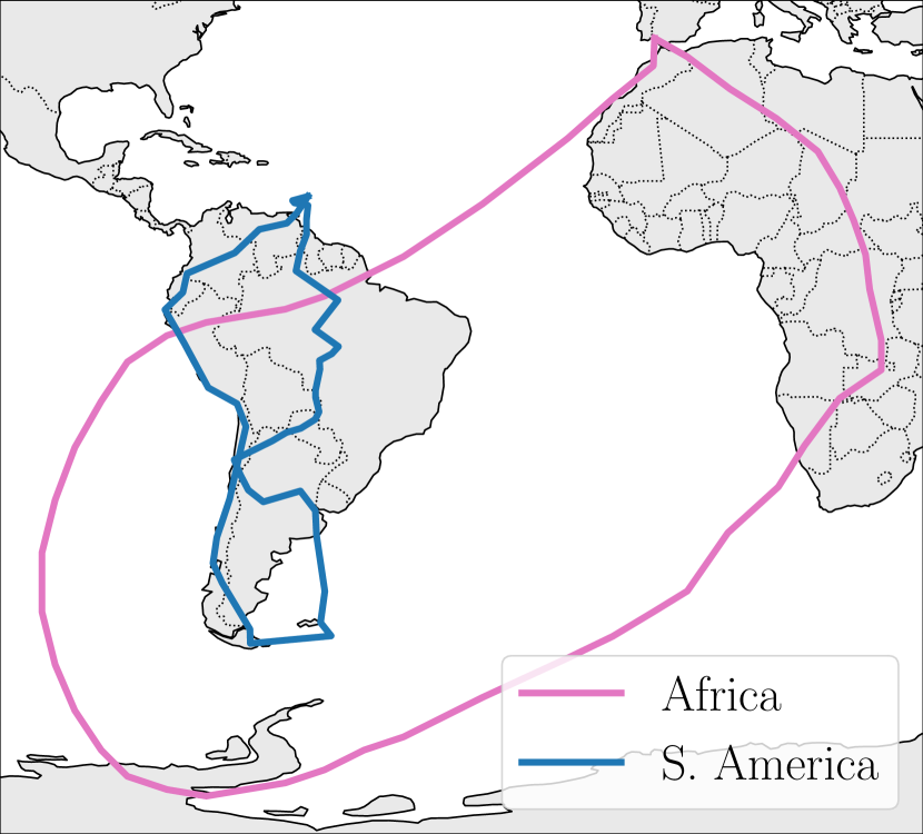
Outlines. We task GPT-4 to provide coordinates for the outlines of countries, rivers, lakes and continents – see Fig. 5. We find a lot of inconsistency with the outputs. Generally, the outlines are geographically close to the target area and bear resemblance, but are frequently the wrong shape and the points crisscross (the outline for Africa is consistently inaccurate). Iteratively improving the response by providing feedback results in better outlines, such as for Australia. We structure the prompt in the same way when querying GPT-4 for the outlines of geographic features:
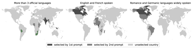
Languages. To assess GPT4’s knowledge of spoken language distribution we ask it to enumerate countries that match language-related criteria: (1) with at least three official, (2) with French and English being spoken and (3) with Romance and Germanic languages widely being spoken. To this end, we used the following prompt template for the 1st prompt:
After obtaining a first set of countries we make use of the interactive chat setting and ask GPT-4 to extend the provided set by asking for any additional countries.
Results (Fig. 6) indicate a good knowledge about the distribution of languages. For the task of identifying countries with more than three official languages GPT-4 misses only one country (Rwanda) from a Wikipedia list but suggest several additional countries. For these additional countries, the predictions still appear reasonable: For example, while India only has two official languages of the government, there are many more at the regional level.
Discussion
We find that GPT-4 has strong capabilities for solving descriptive geographic tasks. It attains low errors in the majority of the factual knowledge retrieval experiments. The error increases as we move towards more difficult queries where the requested information is perhaps not directly seen during training and interpolation is needed. We observe no consistent variation in performance across different continents. We find GPT-4’s output is significantly impacted by prompting: minor variations in output are observed using identical prompts, while there is a large variance for different prompts. Refining the answers with subsequent prompts can yield considerable improvements and serve as a technique for generating better answers.
4.2 Application-Centric
Having demonstrated GPT-4’s underlying understanding of descriptive factual geography, we move towards more complex application-centric experiments that build upon this knowledge. We begin with exploring travel queries, potential downstream applications, as well as real-world and more abstract tasks that probe GPT-4’s logical reasoning capabilities. These experiments further examine the model’s ability to integrate knowledge from different sources. Lastly, we discuss our findings.
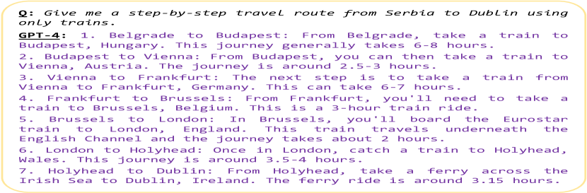
Route planning. We query the model to see if it can provide plausible travel routes between specified places using prompts like:
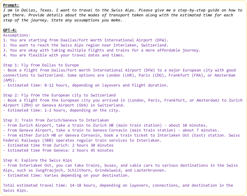
Where the locations can be countries, cities, landmarks, names of streets or buildings, or lat/lon coordinates, and we specify modes of transport such as trains, buses, cars, and airplanes. We verify the accuracy of predictions using ground truth from Google Maps666https://www.google.com/maps. The example in Fig. 7(a) shows that GPT-4 can piece together information from multiple sources to provide a realistic travel plan from Serbia to Dublin using only trains. Similarly, when prompted to provide a travel route from Dallas, Texas to The Swiss Alps, it suggested multiple options including intermediate layovers, taking a combination of airlines, trains, and rental vehicles, as well as recommendations for alpine destinations. We found GPT-4 to be capable of planning routes between short distances if it is allowed flexibility in its response. However, when constrained to urban routing with buses, we found some inaccuracies. Asking for bus routes within London yielded responses that matched the official Transport for London bus route, but exact bus numbers and stops were inaccurate. This might be because real-time bus routes change more frequently compared to airports, train stations, or road networks. Additional experiments and visualisations of the responses are provided in the Appendix.
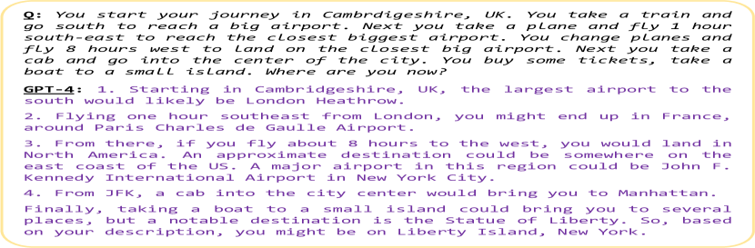
Navigation. Directional navigation is more challenging than generic route planning because we constrict the intermediate objectives, thereby reducing the flexibility and encouraging GPT-4 to logically correlate the given data with its existing geographic knowledge rather than just recall established routes from memory. We use the following style of prompts for these experiments:
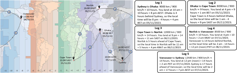
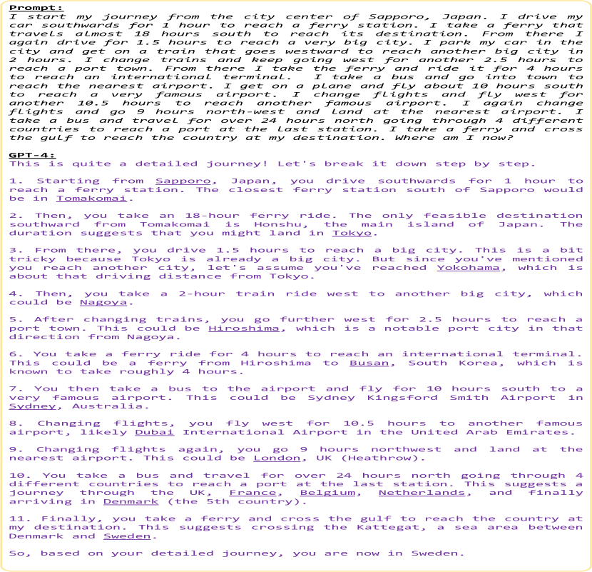
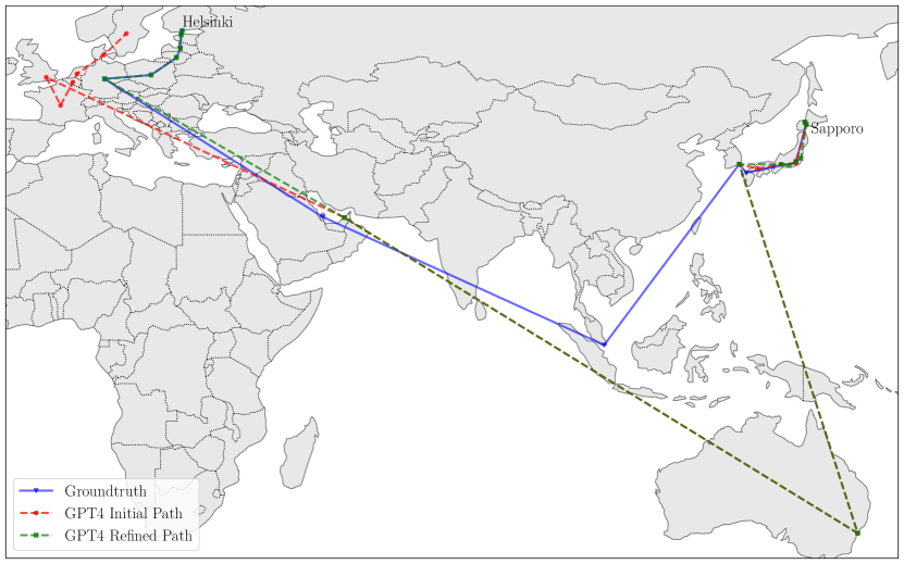
Here, directions can be north, south, south-east, etc. and duration can be minutes, hours, or days. Alternatively, we also use distance-based directions such as “I drive 20 km south”. The prompt in Fig. 7(b) describes a journey from Cambridgeshire London Paris Manhattan Liberty Island. Even without mentioning any specific information about these checkpoints, GPT-4 was able to follow the correct trajectory and reach the expected destination. In additional experiments (see Appendix) we extended the prompt to more complex journeys consisting of stops (e.g., from Sapporo, Japan to Helsinki, Finland). We found that unspecified waypoints resulted in different journeys for the same prompt as it is possible to reach many closely connected places given only the direction and time. However, refining the prompt with small amounts of information such as “We land at a country that is famous for sausages” allows GPT-4 to identify that we arrive in e.g., Germany. Moreover, the length of the route or the number of intermediary stages seems to have little impact on the accuracy of the response since GPT-4 breaks down and deciphers each leg of the journey independently. We found that GPT-4 can accurately track short distances within cities when given exact measurements. Additionally, we verified that for long distance routes between countries, GPT-4 can keep track of changing time zones and estimate travel/arrival times for complex journeys - see Fig. 8; however, it struggles to account for daylight savings if not specified precisely.
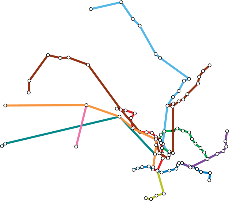
Networks. Having investigated GPT-4’s route planning ability, we explore if it can recreate an entire travel network, e.g., the Hong Kong MTR network. Initially, we ask for a list of all the lines in the network. For each line, we ask for the lat/lon coordinates of the stations, in the correct order. Fig. 9(a) shows the resulting map that closely matches the ground truth (Fig. 8): all the stations are included (aside from those added after 2021) in the correct order (minus forks in the line), though there are inaccuracies in the positioning, especially at interchange stations. Here is the specific two-part prompt we use for each line of the Hong Kong MTR:

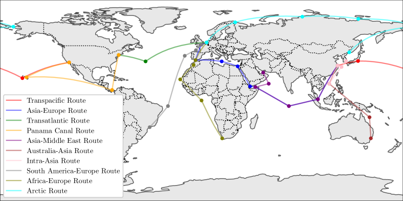
We also generate the maritime shipping routes visualised in Fig. 10. This shows the model’s capabilities of generating coordinates that are not related to specific landmarks, as well as places in the middle of the ocean. We used the following prompt.
Recreations of flight and other rail networks can be found in the Appendix.
Itinerary planning. GPT-4 can act as a travel assistant by providing customised itinerary suggestions based on the provided requirements. We use the following prompt,
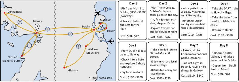
Fig. 11 visualizes the model’s response of an 8-day itinerary for a holiday trip in Ireland, for a fixed budget of $2000. We also found that the model can accommodate to various constraints such as food allergies, requirements for children, and size of travel groups.
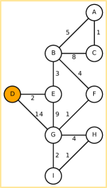
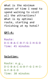
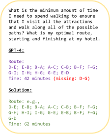
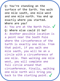
Abstract routing. We probe the underlying route planning logic of GPT-4 by evaluating its performance in an abstract setting. We construct a distributed set of nodes (e.g., attractions) connected by edges (e.g., paths) with associated weights (e.g., times); one of the nodes is specified as the start and end point (e.g., hotel) – see Fig. 12(a). We ask GPT-4 to find an optimal route that visits every node999A variation of the travelling salesman problem. (Fig. 12(b)) and every edge101010i.e., Chinese postman problem. (Fig. 12(c)), and returns to the start. For both, GPT-4 fails to find an optimal route, proposing solutions that needlessly take expensive paths or that miss required paths. Fig. 13 shows a 2-part geographic riddle that GPT-4 answers correctly, even if the question is rephrased.
Landmarks. We find that GPT-4 not only has a remarkable ability to accurately guess landmarks from coordinates but can also produce code for SVG outlines of landmarks. Generated from a single prompt, these illustrations are clearly recognisable (though slightly abstract) – see Fig. 14. In cases where landmarks are relatively isolated, we use the following prompt:


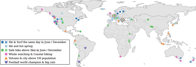
Multi-criteria place retrieval. We task GPT-4 with six prompts where the goal is to generate coordinates that match specific criteria (Fig. 15) to assess its capability to connect different geographic information sources. We used the following prompt for our experiment on multi-criteria place retrieval (for exact prompts see Appendix):
The predictions are mostly correct, with some errors in details, e.g., the red circles in Fig. 15 denote places where a mountain height of over 3 km is absent. Furthermore, there are potential places matching the criteria that are missed, e.g., Mount Teide on Tenerife for hiking in December. Generally, the results indicate good skills in connecting different sources of knowledge and making plausible predictions based on somewhat vague, multi-criteria prompts.
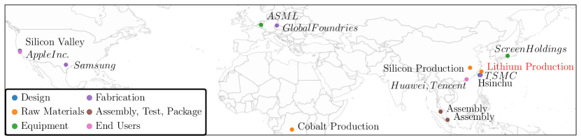
Supply chains. To probe GPT-4’s ability to reason across multiple information sources we ask for key stages and elements in the global semiconductor supply chain, along with locations. From a single prompt-answer, we construct the map shown in Fig. 16. The map includes the majority of the critical components at the correct locations of the supply chain [42], with the exception of lithium production, which is labelled as Australia (a major producer) though given coordinates near China. We create the map using just a single prompt:
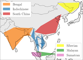
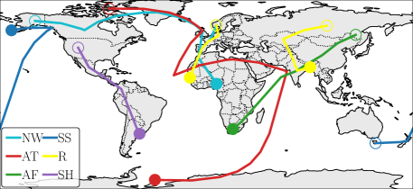
Natural world. We briefly investigate GPT-4’s understanding of wildlife ranges and migrations (see Fig. 17). For tiger subspecies, GPT-4 correctly identifies the 6 living subspecies and their relative ranges. However, the ranges are a combination of current and historic, and are partly incorrect with some (e.g., Malayan) largely in the ocean. For bird migrations, start and end locations are generally correct and the route is highly accurate in some cases (e.g., SH, AF, NW). In a few cases, additional routes are missed. GPT-4 provides reasonable suggestions for how the routes will shift with climate change (e.g., wintering further north, at higher elevations or earlier). To obtain coordinates for the migratory routes we use the following prompt:
Discussion
GPT-4 proves to be skillful at solving a variety of application-centric tasks, further highlighting its potential for downstream tasks. The model can come up with creative, plausible travel routes (though it can be inaccurate with specifics) and shows strong capabilities of direction-based navigation. In plotting the landmark outlines, we illustrate GPT-4’s ability to “see” despite being a language model (similar to [8]); although correct in aspect and content, deficits in composition can be observed. GPT-4 has a clear strength in tasks involving integrating knowledge from various (possibly unstructured) sources across different domains. In practice, the output can serve as proposals that need to be checked in a second stage. On the other hand, we find that GPT-4 struggles with abstract optimisation reasoning without relation to knowledge, leading to the question: to what degree are tasks solved via memorisation rather than reasoning? Given the variability of tasks it solves it seems unlikely to memorise everything, but some things appear to be memorised.
5 Conclusions
We find GPT-4 to have a remarkable understanding of the world, as evidenced by many examples showcasing strong underlying knowledge and logical reasoning. We hope our investigation contributes to useful applications of large language models in the geospatial domain. If provided with access to geographical data feeds, it may ultimately be possible to create tools that improve travel planning and navigation. Despite these impressive examples, it is important to acknowledge that GPT-4 has knowledge gaps and remains prone to hallucination. A key research question highlighted by this work is the degree to which tasks are solved via memorisation or by reasoning.
Broader Impacts. The knowledge and reasoning abilities of GPT-4 towards geographic tasks demonstrate its potential to benefit myriad professions, especially in the travel industries. However, as well as serving as a tool to augment human workers, utilisation of GPT-4, or successors, could also replace human jobs, potentially causing significant economic and social challenges. Looking to the future, if frontier models beyond GPT-4 continue to advance in capabilities, the geographic knowledge and planning abilities present in the current model may later evolve to represent a significant risk, through misuse or misalignment [43].
Limitations. Full reproducibility is not possible for this work due to the stochastic nature of GPT-4111111Full reproducibility could be achieved by setting the temperature parameter to 0, however, constraining the model to be deterministic reduces its creativity, hence does not provide a true measure of capability. and the GPT-4 updates. This, coupled with the breadth of the geographic field, necessitates the mostly qualitative approach we take, preventing us from making comprehensive claims about what GPT-4 knows about the world. Limited access to the model, and limited output and context windows, further restricts the details to which we can conduct our experiments. Finally, access to the visual component of GPT-4 could enable further capabilities; it would be interesting to see how it performs on remote sensing imagery, e.g., the SATIN benchmark [44].
Acknowledgements
This work was supported by the UKRI Centre for Doctoral Training in Application of Artificial Intelligence to the study of Environmental Risks (reference EP/S022961/1), an Isaac Newton Trust grant, an EPSRC HPC grant, the Deutsche Forschungsgemeinschaft (DFG, German Research Foundation) - Project-ID 494541002, the Hong Kong Research Grant Council - Early Career Scheme (Grant No. 27208022), HKU Seed Fund for Basic Research, and the Bangabandhu Science and Technology Fellowship Trust. Samuel would like to acknowledge the support of Z. Novak and N. Novak in enabling his contribution.
References
- [1] Alec Radford, Karthik Narasimhan, Tim Salimans, Ilya Sutskever, et al. Improving language understanding by generative pre-training. 2018.
- [2] Alec Radford, Jeffrey Wu, Rewon Child, David Luan, Dario Amodei, Ilya Sutskever, et al. Language models are unsupervised multitask learners. OpenAI blog, 1(8):9, 2019.
- [3] Tom Brown, Benjamin Mann, Nick Ryder, Melanie Subbiah, Jared D Kaplan, Prafulla Dhariwal, Arvind Neelakantan, Pranav Shyam, Girish Sastry, Amanda Askell, et al. Language models are few-shot learners. Advances in neural information processing systems, 33:1877–1901, 2020.
- [4] OpenAI. Gpt-4 technical report, 2023.
- [5] Hugo Touvron, Thibaut Lavril, Gautier Izacard, Xavier Martinet, Marie-Anne Lachaux, Timothée Lacroix, Baptiste Rozière, Naman Goyal, Eric Hambro, Faisal Azhar, et al. Llama: Open and efficient foundation language models. arXiv preprint arXiv:2302.13971, 2023.
- [6] Aakanksha Chowdhery, Sharan Narang, Jacob Devlin, Maarten Bosma, Gaurav Mishra, Adam Roberts, Paul Barham, Hyung Won Chung, Charles Sutton, Sebastian Gehrmann, et al. Palm: Scaling language modeling with pathways. arXiv preprint arXiv:2204.02311, 2022.
- [7] Teven Le Scao, Angela Fan, Christopher Akiki, Ellie Pavlick, Suzana Ilić, Daniel Hesslow, Roman Castagné, Alexandra Sasha Luccioni, François Yvon, Matthias Gallé, et al. Bloom: A 176b-parameter open-access multilingual language model. arXiv preprint arXiv:2211.05100, 2022.
- [8] Sébastien Bubeck, Varun Chandrasekaran, Ronen Eldan, Johannes Gehrke, Eric Horvitz, Ece Kamar, Peter Lee, Yin Tat Lee, Yuanzhi Li, Scott Lundberg, et al. Sparks of artificial general intelligence: Early experiments with gpt-4. arXiv preprint arXiv:2303.12712, 2023.
- [9] Weiwei Sun, Lingyong Yan, Xinyu Ma, Pengjie Ren, Dawei Yin, and Zhaochun Ren. Is chatgpt good at search? investigating large language models as re-ranking agent. arXiv preprint arXiv:2304.09542, 2023.
- [10] David Noever and Samantha Elizabeth Miller Noever. The multimodal and modular ai chef: Complex recipe generation from imagery. arXiv preprint arXiv:2304.02016, 2023.
- [11] Zheng Yuan, Hongyi Yuan, Chuanqi Tan, Wei Wang, and Songfang Huang. How well do large language models perform in arithmetic tasks? arXiv preprint arXiv:2304.02015, 2023.
- [12] Mingkai Zheng, Xiu Su, Shan You, Fei Wang, Chen Qian, Chang Xu, and Samuel Albanie. Can gpt-4 perform neural architecture search? arXiv preprint arXiv:2304.10970, 2023.
- [13] Harsha Nori, Nicholas King, Scott Mayer McKinney, Dean Carignan, and Eric Horvitz. Capabilities of gpt-4 on medical challenge problems. arXiv preprint arXiv:2303.13375, 2023.
- [14] Dario Amodei, Chris Olah, Jacob Steinhardt, Paul Christiano, John Schulman, and Dan Mané. Concrete problems in ai safety. arXiv preprint arXiv:1606.06565, 2016.
- [15] Ziwei Ji, Nayeon Lee, Rita Frieske, Tiezheng Yu, Dan Su, Yan Xu, Etsuko Ishii, Ye Jin Bang, Andrea Madotto, and Pascale Fung. Survey of hallucination in natural language generation. ACM Computing Surveys, 55(12):1–38, 2023.
- [16] Nick Bostrom. Superintelligence: Paths, Dangers, Strategies. Oxford University Press, Inc., USA, 1st edition, 2014.
- [17] Russell A Poldrack, Thomas Lu, and Gašper Beguš. Ai-assisted coding: Experiments with gpt-4. arXiv preprint arXiv:2304.13187, 2023.
- [18] Julian Hazell. Large language models can be used to effectively scale spear phishing campaigns. arXiv preprint arXiv:2305.06972, 2023.
- [19] Debadutta Dash, Rahul Thapa, Juan M Banda, Akshay Swaminathan, Morgan Cheatham, Mehr Kashyap, Nikesh Kotecha, Jonathan H Chen, Saurabh Gombar, Lance Downing, et al. Evaluation of gpt-3.5 and gpt-4 for supporting real-world information needs in healthcare delivery. arXiv preprint arXiv:2304.13714, 2023.
- [20] John Giorgi, Augustin Toma, Ronald Xie, Sondra Chen, Kevin R An, Grace X Zheng, and Bo Wang. Clinical note generation from doctor-patient conversations using large language models: Insights from mediqa-chat. arXiv preprint arXiv:2305.02220, 2023.
- [21] Xiangru Tang, Andrew Tran, Jeffrey Tan, and Mark Gerstein. Gersteinlab at mediqa-chat 2023: Clinical note summarization from doctor-patient conversations through fine-tuning and in-context learning. arXiv preprint arXiv:2305.05001, 2023.
- [22] Jungo Kasai, Yuhei Kasai, Keisuke Sakaguchi, Yutaro Yamada, and Dragomir Radev. Evaluating gpt-4 and chatgpt on japanese medical licensing examinations. arXiv preprint arXiv:2303.18027, 2023.
- [23] Yuqing Wang, Yun Zhao, and Linda Petzold. Are large language models ready for healthcare? a comparative study on clinical language understanding. arXiv preprint arXiv:2304.05368, 2023.
- [24] Gerd Kortemeyer. Can an ai-tool grade assignments in an introductory physics course? arXiv preprint arXiv:2304.11221, 2023.
- [25] Kent K Chang, Mackenzie Cramer, Sandeep Soni, and David Bamman. Speak, memory: An archaeology of books known to chatgpt/gpt-4. arXiv preprint arXiv:2305.00118, 2023.
- [26] Eduardo C Garrido-Merchán, José Luis Arroyo-Barrigüete, and Roberto Gozalo-Brihuela. Simulating hp lovecraft horror literature with the chatgpt large language model. arXiv preprint arXiv:2305.03429, 2023.
- [27] Saeid Ashraf Vaghefi, Qian Wang, Veruska Muccione, Jingwei Ni, Mathias Kraus, Julia Bingler, Tobias Schimanski, Chiara Colesanti-Senni, Dominik Stammbach, Nicolas Webersinke, et al. Chatclimate: Grounding conversational ai in climate science. 2023.
- [28] Hanmeng Liu, Ruoxi Ning, Zhiyang Teng, Jian Liu, Qiji Zhou, and Yue Zhang. Evaluating the logical reasoning ability of chatgpt and gpt-4. arXiv preprint arXiv:2304.03439, 2023.
- [29] Zhenlong Li and Huan Ning. Autonomous gis: the next-generation ai-powered gis. arXiv preprint arXiv:2305.06453, 2023.
- [30] Tuan-Phong Nguyen, Simon Razniewski, Aparna Varde, and Gerhard Weikum. Extracting cultural commonsense knowledge at scale. arXiv preprint arXiv:2210.07763, 2022.
- [31] Da Yin, Hritik Bansal, Masoud Monajatipoor, Liunian Harold Li, and Kai-Wei Chang. Geomlama: Geo-diverse commonsense probing on multilingual pre-trained language models. arXiv preprint arXiv:2205.12247, 2022.
- [32] Ruixue Ding, Boli Chen, Pengjun Xie, Fei Huang, Xin Li, Qiang Zhang, and Yao Xu. A multi-modal geographic pre-training method. arXiv preprint arXiv:2301.04283, 2023.
- [33] Jizhou Huang, Haifeng Wang, Yibo Sun, Yunsheng Shi, Zhengjie Huang, An Zhuo, and Shikun Feng. Ernie-geol: A geography-and-language pre-trained model and its applications in baidu maps. In Proceedings of the 28th ACM SIGKDD Conference on Knowledge Discovery and Data Mining, pages 3029–3039, 2022.
- [34] World Bank. World development indicators: Population, total, 2021.
- [35] World Bank. World development indicators: Life expectancy at birth, total (years), 2020.
- [36] World Bank. World development indicators: Co2 emissions (metric tons per capita), 2019.
- [37] World Bank. World development indicators: Land area (sq. km), 2020.
- [38] Yash Yadav. List of mountains in the world, v2. https://www.kaggle.com/datasets/codefantasy/list-of-mountains-in-the-world, 2022.
- [39] Yash Yadav. World cities database, v5. https://www.kaggle.com/datasets/juanmah/world-cities, 2023.
- [40] GeoNames. Geonames. https://www.geonames.org.
- [41] European Space Agency and Sinergise. Copernicus global digital elevation model. Distributed by Microsoft Planetary Computer, 2021.
- [42] Chris Miller. Chip War: The Fight for the World’s Most Critical Technology. Simon and Schuster, 2022.
- [43] Toby Shevlane, Sebastian Farquhar, Ben Garfinkel, Mary Phuong, Jess Whittlestone, Jade Leung, Daniel Kokotajlo, Nahema Marchal, Markus Anderljung, Noam Kolt, et al. Model evaluation for extreme risks. arXiv preprint arXiv:2305.15324, 2023.
- [44] Jonathan Roberts, Kai Han, and Samuel Albanie. Satin: A multi-task metadataset for classifying satellite imagery using vision-language models. arXiv preprint arXiv:2304.11619, 2023.
Appendix
We structure this Appendix to our main paper submission into two parts. First, we provide general remarks on our experimentation (Sec. A). Next, we include additional information on the investigations we carried out including: information required for reproducibility, prompts and extra supportive experiments (Sec. B).
A General Remarks
A number of comments can be made about behaviours we observed throughout our experimentation.
Counting. A common issue was GPT-4’s inability to consistently accurately count. This was especially apparent when asking for specific numbers of outputs (e.g., coordinates for 50 points along the outline of a country or when asking for the distance between numerous pairs of coordinates), in which GPT-4 would frequently return a different length output.
Output format. Another inconsistency is in the formatting of the output. For the majority of our experiments, we ask for output in python syntax, expecting the relevant part of the answer to be returned in a codeblock environment (when using the ChatGPT interface). However, output was sometimes returned as a python list in the code block (as expected) but sometimes as plaintext with or without linebreaks.
Answering. With some tasks, convincing GPT-4 to provide the desired out was difficult, requiring many re-runs. We found this typically for tasks that are perhaps not obviously expected of an LLM, such as providing the coordinates for area outlines or SVG code for landmarks.
B Additional Details, Prompts and Supportive Experiments
Here, we progress through each investigation from Section 4 of the main paper. We include details of the specific prompts used and, where relevant, supplementary details to aid in the understanding of how we conducted each experiment. Furthermore, we present results for additional experiments that were carried out as part of this work that, due to length constraints, we were unable to incorporate into the main paper.
B.1 Population, Life Expectancy and CO2 Emissions
Population
We used the following prompt for country population estimation:
Country names were taken from the ground truth [34].
Life Expectancy
We used the following prompt for country life expectancy estimation:
Country names were taken from [35]. The ground-truth data contained numerous entries for regions that are not countries, such as territories (e.g., Cayman Islands), special administrative regions (e.g., Macao), and other categories (e.g., Heavily indebted poor countries (HIPC)). We disregarded the estimations for these regions.
CO2 Emissions
We used the following prompt for country CO2 emissions estimation:
Country names were taken from the ground truth [36]. As before, the ground-truth data contained numerous entries for regions that are not countries. GPT-4 successfully returned ‘None’ for these.
B.2 Area
We used the following prompt for country area estimation:
Country names were taken from the ground truth [37]. As before, the ground-truth data contained numerous entries for regions that are not countries. GPT-4 successfully returned ‘None’ for non-country categories (e.g., Heavily indebted poor countries (HIPC)).
B.3 Height
We used the following prompt for mountain height estimation:
Mountain names were taken from the ground truth [38].
B.4 Location
Name Coordinate
Country names were taken from the ground truth [39].
Coordinate Name
Country lat/lon coordinates were taken from the ground truth [39].
B.5 Distance Estimation
We used the following prompt for distance estimation:
In cases where the number of outputs did not match the number of provided cities, we repeated the prompt.
We had to change the prompt because ChatGPT started to refuse to provide distances (possibly as a consequence of backend changes to ChatGPT’s configuration). On results indicated by asterisk (*) were obtained using the following prompt.
B.6 Topography
For the elevation plots shown in the main paper, we use the following prompts:
The respective coordinates for the lines are
blue:
45.00000, 11.20000;
45.33333, 11.23333;
45.66667, 11.26667;
46.00000, 11.30000;
46.33333, 11.33333;
46.66667, 11.36667;
47.00000, 11.40000;
47.33333, 11.43333;
47.66667, 11.46667;
48.00000, 11.50000;
orange:
45.00000, 5.20000;
45.02667, 5.64444;
45.05333, 6.08889;
45.08000, 6.53333;
45.10667, 6.97778;
45.13333, 7.42222;
45.16000, 7.86667;
45.18667, 8.31111;
45.21333, 8.75556;
45.24000, 9.20000;
green:
43.00000, 10.20000;
43.23333, 10.53333;
43.46667, 10.86667;
43.70000, 11.20000;
43.93333, 11.53333;
44.16667, 11.86667;
44.40000, 12.20000;
44.63333, 12.53333;
44.86667, 12.86667;
45.10000, 13.20000;
We found that explicitly asking for coordinates works better than specifying trajectory endpoints only: For the prompt
GPT-4 predicted 200, 350, 450, 600, 800, 1000, 1200, 1400, 1600 and 1800, which is substantially worse than the predictions above.
B.7 Outlines
This section outlines the prompts we used for the Outlines experiment in the main paper. The prompts are arranged in order from L-R for subfigures in the figure in the main paper.
Australia
When creating the outline of Australia, we experiment with providing feedback on the outlines produced by GPT-4 in an attempt to incrementally update and improve the outline.
Here is our starting prompt:
Iteration 0.
These are the incrementally suggested improvements.
Iteration 1.
Iteration 2.
Iteration 3.
Iteration 4.
Iteration 5.
Iteration 6.
Continental USA
Lake Winnipeg
Lake Superior
UK Rivers
Where <river_name> = Thames, Trent, Severn.
France Rivers
Where <river_name> = Loire, Seine.
Continents
B.8 Languages.
To assess GPT4’s knowledge of spoken language distribution we used the following prompts (1st prompt):
B.9 Route Planning
General Planning.
General route planning involves specifying a source and requesting a path to reach the required destination. GPT-4 is adept at these queries because they do not impose any constraints, and allows flexibility in choosing the mode of travel. Fig. 18 shows the prompt and response for the trip from Dallas, Texas to The Swiss Alps. The model is capable of breaking down the journey into multiple segments and solve the problem similar to how a human would.
Trains.
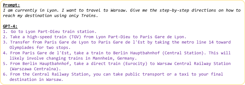
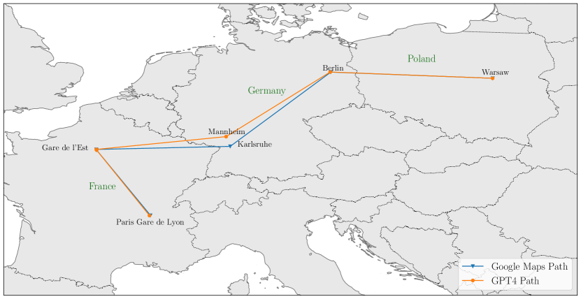
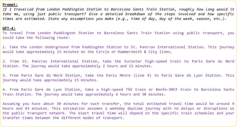
In Fig. 19 we prompt the model to provide a travel route using only trains from Lyon to Warsaw. The model’s suggested path matches closely with the recommended route by Google Maps. Based on the current availability of buses and trains, the google maps api forecasts a number of potential routes. In contrast, GPT-4 most of the time only specifies one probable route. However, the model was able to correctly identify the individual train stations and lines that must be taken in order to get to the desired location, which closely fits the groundtruth prediction (Fig. 20). Additionally, we asked the model to predict how long each leg of a trip from London Paddington Station to Barcelona Sants Station would take (Fig. 21). The model’s predictions for each leg of the journey agree with Google Maps’ best estimates very well.
Buses.
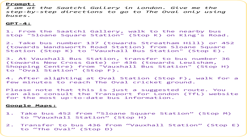
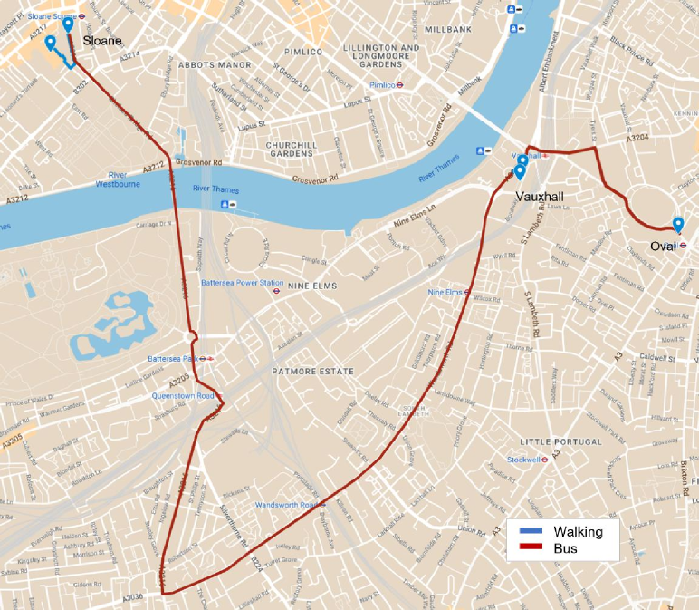
Compared to train or aviation routes, navigation with buses are more difficult because they can change overtime. Since GPT-4 has a knowledge cutoff after 2021, it does not know the realtime bus route information (which it is aware of). In Fig. 22(a) we prompt the model to generate a bus route from Saatchi Gallery, London to The Oval, London. The output includes a combination of walking and travel by bus along with specifications on where to change buses and the individual stoppages (Fig. 23). We verified the proposed route with the official TFL (Transport for London) bus route database and found that the bus specified in the response runs between the specified bus stops. However, the exact stop number is inaccurate. The current database shows that the bus leaves from stop M whereas GPT-4 suggested stop K.
Driving.
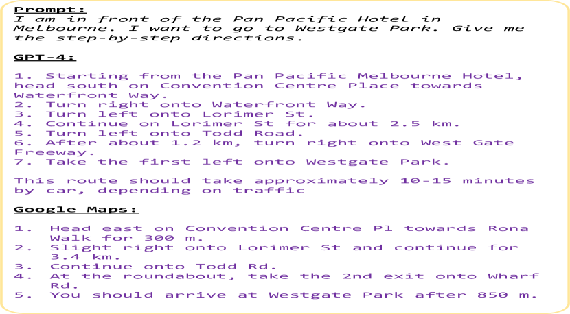
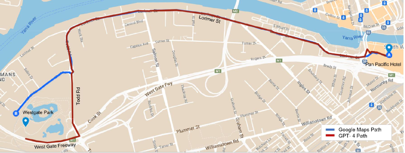
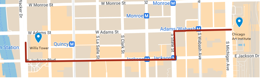
Intra or Inter-city driving route prediction in comparison to other modes of transport are fairly trivial because road networks remain consistent over time, and is easy to locate in terms of distance measure and landmark positioning. Even with a very simple prompt such as Tell me how to go from ’A’ to ’B’ is enough to generate a fairly accurate travel plan. We show a comparison between GPT-4 output (Fig. 22(b)) and Google Maps prediction for a driving route from The Pan Pacific Hotel, Melbourne to Westgate Park, Melbourne (Fig. 24).
B.10 Navigation
Long Distance Travel.
This includes navigation between multiple countries and involving different modes of transport given only direction or distance based queries. Fig. 25 shows the prompt for journey from Sapporo, Japan to Helsiniki, Finland consisting of 15 intermediate stops. We found that extending the prompt with additional steps has minimal effect on the model’s response as long as it keeps within the context window. Since the model is breaking down each leg of the journey and evaluating step-by-step, long journeys are the same as shorter ones. However, there is a high degree of uncertainty in the response if the prompt contains unspecified directional locations. Such as, it is possible to reach both Kyoto and Osaka via a two hour train ride from Tokyo. This type of randomness is observable when travelling between countries in Europe, states in the US, and islands in South Asia. If the prompts are refined with small amounts of information regarding the particular waypoints, the model can better differentiate between these neighboring regions. GPT-4 was able to correlate Salmon-Soup with Helsinki and accurately arrived at the final location. The whole journey is visualized in Fig. 26.

Short Distance Travel.
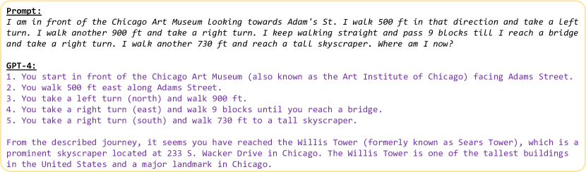
In addition to travel between countries, we also evaluated if GPT-4 can identify short immediate distances between buildings within a city (Fig. 27). We specify the distances in feet (ft) and direction in the perspective of someone walking down the road. We found that the model can accurately track the distances and turns along the road to reach the destination in more well documented cities like New York or Chicago, but not for small paces like Daventry, UK.
Time zones.
We use the following prompt to specify the journey , and evaluate if GPT-4 can keep track of changing time zones.
B.11 Networks
Hong Kong MTR Network
We begin by prompting GPT-4 for an ordered list of the stations on each line. We find if we ask for coordinates for the stations without this initial prompt, the model misses 30-40% of the stations on the line when we ask for coordinates.
Airport Network
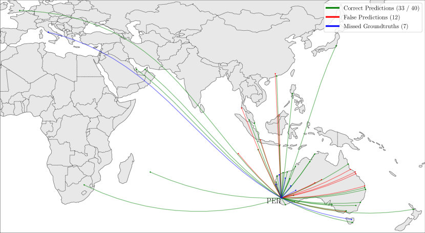
We tried to create the network of all airports that are directly connected to Perth International Airport (PER). We first used the following prompt,
However, the network only listed a few locations and responded that the full list of airports are too large for the response. So, we broke down the prompt into two query segments - list of all internal airport, and a list of all external airports. This was prompted as,
The result when plotted gave the airport network in Fig. 29. GPT-4 was able to identify 33 out of the 40 airports, but also made 12 false predictions.
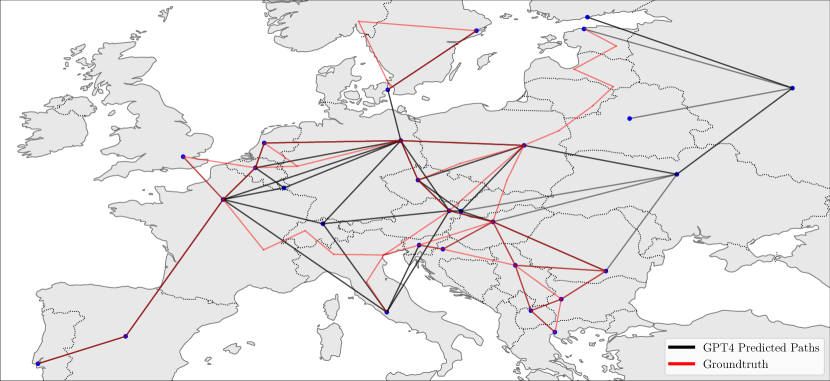
Rail Network. We plot the European Railway Network in Fig. 30. We first queried for the pairwise list of countries that are connected with each other, and next the coordinates for a major train station in each country. The two part prompt is as follows,
Response:
We plotted the coordinates and connected the lines between the pairwise countries. Contrary to the groundtruth, GPT-4 kept Russia as part of Europe. Moreover, we only ask for a single rail station from each country. This removes some major stations like Munich, Frankfurt, and Lyon.
B.12 Itinerary Planning
Itinerary prompts involve specifying the start location, destination location, intermediate waypoints, budget limitations, duration of travel, and any additional constraints. The prompt for the 8 days itinerary in Ireland is as follows:
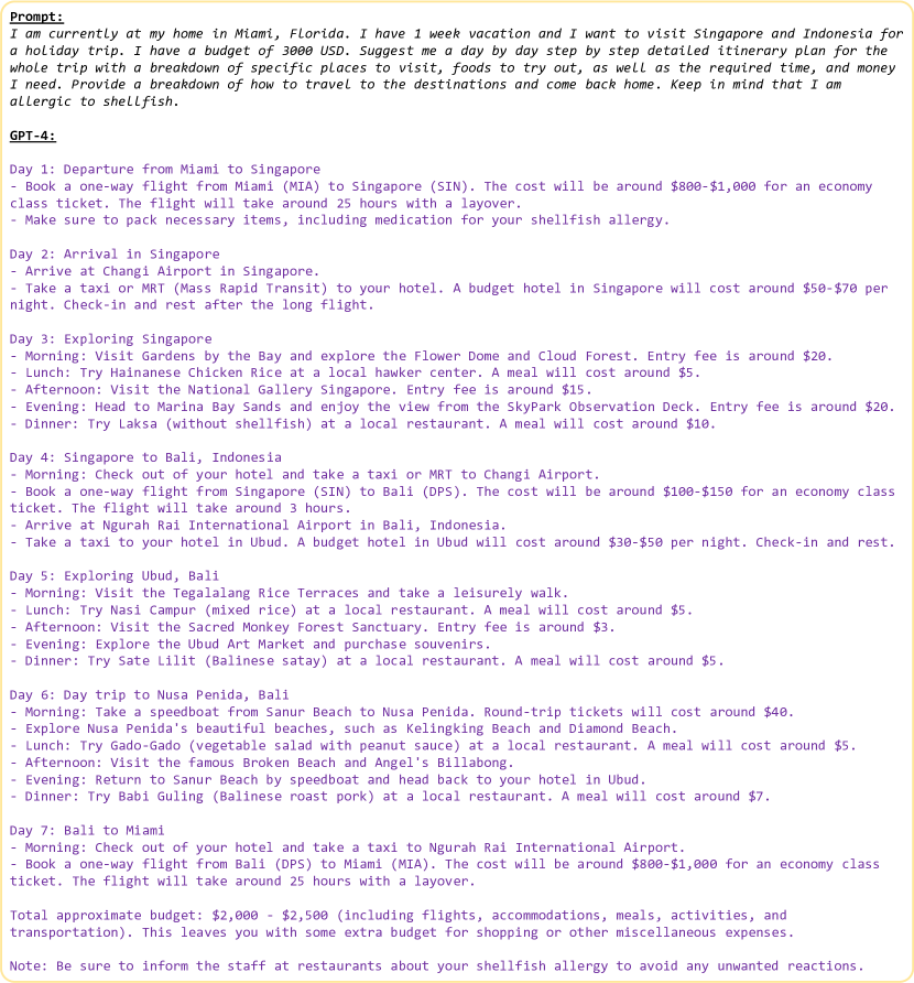
We also query for a one week vacation combining Singapore and Indonesia, starting from Miami with more specific prompt and constraints. Fig. 31 shows the response which includes detailed guide on travel, food, cost per day, as well as recommendations adhering to the allergy and food constraints. This shows GPT-4’s capabilities as a personalized travel agent.
B.13 Abstract Routing
Every node
We used the following prompt for finding the optimum route that visits every edge in the graph.
Every edge
We used the following prompt for finding the optimum route that visits every node in the graph.
Graph Description We verify that GPT-4 correctly interprets the description of the graph by asking for the adjacency matrix from the descriptions above:
Prompt:
Response:
GPT-4 also correctly returns the adjacency list:
Prompt:
Response:
Alternative wording for Riddle
We reword the riddle used in the main paper, altering the context to provide a second assessment of GPT-4’s ability to answer the riddle correctly with less chance of the exact question/answer being seen during training.
Prompt:
Response:
B.14 Landmarks
We use two different prompts to generate SVG code for the outline of landmarks.
Isolated Landmarks
For landmarks that are isolated and far from other landmarks, we used these prompts:
and
Where <Landmark_Lat/Lon_Coordinates> are the coordinates for the Statue of Liberty and Giza Pyramids Complex. Coordinates were taken from Wikipedia and Google Maps. For these landmarks, we find GPT-4 is able to accurately identify the landmark from the coordinates and provide the SVG code for a recognisable outline.
Dense Landmarks
For landmarks that are located closely with others, we specify the landmark name in the prompt rather than providing a location. For example, “London skyline” is not possible to specify using a single coordinate, and the Gardens by the Bay are located too close to the Marina Bay Sands hotel for a single coordinate to distinguish the two.
For the London Skyline, we used this prompt:
For the Gardens by the Bay, we used this prompt:
We include GPT-4’s SVG outlines for additional landmarks that we experimented with in Fig. 32.


B.15 Multi-criteria Place Retrieval
We used the following prompt for our experiment on multi-criteria place retrieval:
We found that asking for a specific coordinate format helped as GPT-4 would sometimes generate inconsistent coordinates otherwise. If the output was not only provided as a Python list, we extracted the coordinates manually.
B.16 Supply Chains
We used the following prompt for analysing the global semiconductor supply chain:
We then ask for assistance with plotting:
B.17 Natural World
Wildlife Ranges
We start with the initial prompt:
We then repeatedly use the following prompt, replacing tiger subspecies with each subspecies returned in the first answer:
Bird Migrations
We used the following prompt for evaluating GPT-4’s knowledge of bird migrations: