A survey of urban drive-by sensing: An optimization perspective
Abstract
Pervasive and mobile sensing is an integral part of smart transport and smart city applications. Vehicle-based mobile sensing, or drive-by sensing (DS), is gaining popularity in both academic research and field practice. The DS paradigm has an inherent transport component, as the spatial-temporal distribution of the sensors are closely related to the mobility patterns of their hosts, which may include third-party (e.g. taxis, buses) or for-hire (e.g. unmanned aerial vehicles and dedicated vehicles) vehicles. It is therefore essential to understand, assess and optimize the sensing power of vehicle fleets under a wide range of urban sensing scenarios. To this end, this paper offers an optimization-oriented summary of recent literature by presenting a four-step discussion, namely (1) quantifying the sensing quality (objective); (2) assessing the sensing power of various fleets (strategic); (3) sensor deployment (strategic/tactical); and (4) vehicle maneuvers (tactical/operational). By compiling research findings and practical insights in this way, this review article not only highlights the optimization aspect of drive-by sensing, but also serves as a practical guide for configuring and deploying vehicle-based urban sensing systems.
Keywords: crowdsensing; drive-by sensing; vehicle mobility; optimization; smart cities
1 Introduction
Central to many smart city applications is the capability to sense and monitor a variety of entities ranging from natural and built environment (e.g. through ubiquitous and pervasive sensing) to domestic and industrial processes (e.g. through IoT technologies) (Chan, , 2021; Du et al., , 2019; Zanella et al., , 2014). Both cases benefit from recent development of wireless technology and miniaturized sensing apparatus (Perera et al., , 2014; Liu et al., , 2016). When it comes to the sensing of outdoor urban environment, such as air quality and traffic states, the uprise of mobile sensors has enabled extensive spatial-temporal coverage by leveraging human mobility in a cost-effective way, giving rise to a rapidly expanding literature on mobile crowdsensing (Ganti et al., , 2011; Liu et al., , 2005; Ma et al., , 2014; Zhang et al., , 2014). For a general review of the architecture, technology, and applications of mobile crowdsensing, the reader is referred to Yurur et al., (2016); Capponi et al., (2019) and Laport-López et al., (2020).
According to the type of sensor hosts, mobile crowdsensing can be categorized as community sensing (CS) and drive-by sensing (DS), where the former utilizes sensors embedded in smartphones or wearable devices (Jiang et al., , 2011; Duan et al., , 2014; Yang et al., , 2012; SM et al., , 2019), and the latter relies on road or airborne vehicles such as taxis, buses, trams and unmanned aerial vehicles (UAVs) (Lee and Gerla, , 2010; Sanchez et al., , 2014). In general, DS outperforms CS in terms of geographic extent, temporal duration, reliability, cost-effectiveness and data quality (Yi et al., , 2015), and has been widely seen in various smart city applications such as air quality sensing (Kumar et al., , 2015; Hasenfratz et al., , 2015; Song et al., , 2021; Mahajan et al., , 2021; Marjovi et al., , 2015), traffic conditions estimation (Guo et al., , 2022; Li et al., , 2009; Yoon et al., , 2007), urban heat island phenomenon (Fekih et al., , 2021), noise monitoring (Alsina-Pagés et al., , 2017), and infrastructure health inspection (Wang et al., , 2014; Eriksson et al., , 2008; Malekjafarian et al., , 2022).
In drive-by sensing, the sensors may be carried by taxis (Honicky et al., , 2008; Mathur et al., , 2010), transit vehicles such as buses or trams (Kang et al., , 2016; Saukh et al., , 2012; Guan et al., , 2016), service vehicles such as trash trucks (Anjomshoaa et al., , 2018; deSouza et al., , 2020), dedicated vehicles (Messier et al., , 2018; Von Fischer et al., , 2017), and UAVs (Hu et al., , 2019; Li et al., , 2022; Hemamalini et al., , 2022). Clearly, the spatial-temporal distribution of sensors, and subsequently their sensing performance as a system, are dependent on the mobility patterns of the host vehicles (Anjomshoaa et al., , 2018). Understandably, the movement of third-party vehicles (taxis, buses, logistic vehicles) are confined to their designated routes or service-oriented operations, which are not specifically aligned with sensing objectives. Therefore, the allocation of sensors to such vehicles (strategic), as well as their full or partial maneuvers (tactical or operational), constitute an important aspect of vehicle-based urban sensing. Many such issues can be addressed as optimization problems, with varying degrees of spatial-temporal granularity, decision resolution, information availability, and user preferences. The following four questions are most commonly addressed in the literature, which are essential for the development and adoption of drive-by sensing systems:
-
Q1.
How to quantify the spatial-temporal sensing quality?
-
Q2.
What is the sensing power of a vehicle fleet of certain type (e.g. taxi, bus, UAVs)?
-
Q3.
How to deploy/allocate a set of sensors to a vehicle fleet?
-
Q4.
How to operationally maneuver a vehicle fleet to increase their sensing power?
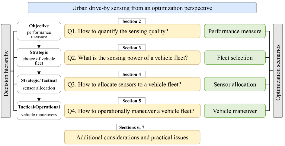
The logical flow of these four questions is illustrated in Figure 1. Q1 serves as the foundation of optimization approaches, as various sensing preferences or objectives lead to different deployment and maneuver strategies and could even influence the choice of sensing vehicles. Q2 offers insights into DS by profiling different types of vehicle fleet in terms of the extent and granularity of their spatial-temporal coverage, operational reliability, cost-effectiveness and flexibility. Q3 is most commonly investigated in the literature, especially for taxis and buses without operational intervention. Q4 concerns with full or partial control over the fleet (e.g. vehicle routing and scheduling, incentivizing schemes) in the interest of sensing quality improvement.
These four questions also reflect a natural order of decision making, starting from the performance measure (Q1-optimization objective), then the choice of vehicle fleet (Q2-strategic), followed by the sensor allocation (Q3-strategic/tactical), and furthered with vehicle maneuvers (Q4-tactical/operational). For a given urban sensing application with certain budget, the optimal or ideal distribution of the sensors in a space-time domain is usually difficult to achieve in reality, due to the physical constraints imposed by the mobility patterns of the host vehicles. Therefore, the essential purpose of optimization, whether regarding fleet selection (Q2), sensor allocation (Q3), or vehicle maneuver (Q4), is to remove those constraints as much as possible, such that the resulting sensing efficacy is engineered towards its optimal state. This motivates this paper to take on an optimization perspective in portraying drive-by sensing.
We offer the following discussion in the remainder of this paper. Section 2 reviews quantitative approaches that assess the goodness of sensing (Q1). Section 3 presents results and insights regarding the sensing capabilities of different types of vehicle fleets (Q2). Section 4 focuses on the optimization problem of allocating sensors to a chosen fleet (Q3). Section 5 discusses measures and mechanisms that influence the operation of sensing fleets (Q4). Section 6 offer some further discussion on theoretical and practical issues in drive-by sensing, following by concluding remarks in Section 7
2 Quantifying drive-by sensing quality
Quantification of the sensing quality is a prerequisite of DS system deployment. The data requirement of drive-by sensing depends on the subject of sensing and the underlying application (Restuccia et al., , 2017). For example, in crowdsourced traffic state (speed, travel time) monitoring, typically based on fine-grained GPS trajectory data, it is critical to collect samples that cover most main streets at a relatively high frequency since traffic states changes dynamically. In air quality or urban heat island sensing, the requirement on spatial-temporal resolution of the data is not as high, since pollutant concentration or temperature tend to vary relatively smoothly across the spatial-time domain.
In this section, we provide a unified quantification framework that subsume different approaches in the drive-by sensing literature. The area of interest is partitioned into subregions and the analysis horizon is discretized into intervals . In the literature, can be treated as a square region (i.e. mesh, grid) (Chen et al., , 2020; Zhao et al., , 2015) or a street segment (O’Keeffe et al., , 2019; Ali and Dyo, , 2017). In the following subsections, we present three types of quantification methods, based on the sample size, temporal gap, and measurement distributions, respectively. We also use the term ‘sensing score’ to refer to the goodness of sensing in a general setting.
2.1 Sensing score as a function of sample size
The first method quantifies the sensing quality as a non-decreasing function of the number of visits (samples) each sub-region receives. Specifically, let be the number of sensing vehicles covering region during time interval . The corresponding sensing score, expressed as a function , reads:
| (2.1) |
Eqn (2.1) uses a cut-off threshold to determine 0-1 sensing scores. In many studies (Ali and Dyo, , 2017; Tonekaboni et al., , 2020) is set to be 1, so that a single visit achieves the maximum score. In this case, the sensing objective focuses almost entirely on spatial extent of the coverage. Other studies (Cruz et al., 2020a, ; Zhao et al., , 2014) consider , which is in the interest of more frequent and reliable sampling achieved by multiple visits. As increases, the focus shifts from spatial coverage to sample size per unit area, or the temporal frequency of data collection.
The overall spatial-temporal coverage can be quantified as (Dai and Han, , 2023)
| (2.2) |
where and are, respectively, temporal and spatial weights assigned to the discrete units in the space-time domain. These weights should be determined jointly by the sensing application scenario (e.g. air quality or traffic state monitoring) and the specific situation of the target area.
2.2 Sensing score as a function of temporal gap
Another line of research focus on the temporal distribution of sensing measurements, by considering the so-called gap interval, during which a sub-region is not covered by any sensors. Specifically, consider a time interval , during which is covered by sensing vehicles. Let be the length of the i-th gap interval, and be the set of gap interval lengths during . Then, the sensing quality can be quantified in terms of the following quantities:
-
•
The maximum gap between two consecutive visits (Pasqualetti et al., , 2012): , where smaller implies higher sensing quality;
- •
-
•
The averaged gap with buffers (Ji, , 2021): , where is a fixed buffer such that any gap interval shorter than is ignored from the calculation (the buffer can be tailored to depend on or to diversify the sensing requirements);
-
•
The empirical distribution (cumulative distribution function) of the gap interval lengths (Zhao et al., , 2015): .
For the first three quantification methods, the overall sensing score can be calculated as
| (2.3) |
2.3 Sensing score measured as the difference from target distribution
The third method differs considerably from the first two by focusing on the spatial-temporal distribution of the sensing scores. This approach typically requires knowledge of an a priori (target) distribution, and some form of dissimilarity measure of two distributions. For example, (Xu et al., , 2019) consider the Kullback-Leibler (KL) divergence between the distribution of actual sensing rewards and a target distribution. The KL-divergence from Bayesian inference (Kullback and Leibler, , 1951) measures the change of information when one revises beliefs from the prior distribution to the posterior distribution .
Formally, recalling that denotes the number of visits of region during time interval , we let be an arbitrary sensing reward function. Then define the distribution
| (2.4) |
Let be a discrete target distribution defined on the domain . The KL divergence of from is
| (2.5) |
2.4 Discussion
The selection of quantification measures for sensing quality is closely related to the underlying sensing application. For example, traffic congestion and air quality monitoring require repeated sampling of the same sub-region (or road segment) since each sample (vehicle visit) may be subject to unobserved randomness. Therefore, the sensing quality can be quantized using the first method (2.1). As another example, quantities such as parking availability require high-frequency monitoring, and the second method based on the temporal spacing of visits would be appropriate. The third method is applicable when a target distribution of sensing resources is given, which typically arises in comprehensive area survey such as air quality and urban heat island monitoring. However, we note that, diversified sensing priorities or requirements even for the same sensing subject may lead to different evaluation methods. Table 1 categorizes relevant literature by their sensing evaluation methods, vehicles used and sensing application.
| Study | Quantification methods | Fleet type | Sensing scenario |
| Yu et al., (2021) | sample size | Taxi | Traffic condition |
| Guo et al., (2022) | sample size | Taxi | Traffic condition |
| Singh et al., (2020) | sample size | Taxi | Not specified |
| Wang et al., (2018) | sample size | Bus | Traffic condition |
| Gao et al., (2016) | sample size | Bus | Air quality |
| Yu et al., (2012) | sample size | Bus | Air quality |
| Kaivonen and Ngai, (2020) | sample size | Bus | Air quality |
| Agarwal et al., (2020) | sample size | Taxi & bus | Air quality |
| Cruz Caminha et al., (2018) | sample size | Bus | Air quality; traffic condition |
| Cruz et al., 2020a | sample size | Bus | Waste disposal; air quality; noise |
| Cruz et al., 2020b | sample size | Bus | Waste disposal; Air quality; noise |
| Ali and Dyo, (2017) | sample size | Bus | Road surface |
| Tonekaboni et al., (2020) | sample size | Bus | Heat island |
| Trotta et al., (2018) | sample size | UAV | Built environment |
| Rashid et al., (2020) | sample size | UAV | Disaster response |
| Mathur et al., (2010) | temporal gap | Taxi | Parking availability |
| Bock et al., (2017) | temporal gap | Taxi | Parking availability |
| Pasqualetti et al., (2012) | temporal gap | Robot | Built environment |
| Asprone et al., (2021) | temporal gap | Taxi | Not specified |
| Ji, (2021) | temporal gap | Dedicated vehicle | Air quality |
| Zhao et al., (2015) | temporal gap | Taxi | Not specified |
| Xu et al., (2019) | target distribution | Taxi | Air quality; built environment |
3 Assessing the sensing power of vehicle fleets
In urban drive-by sensing, the selection of vehicle fleet to carry out the sensing task is a strategic decision, which relies on knowledge of the candidates’ sensing capabilities, as well as the set-up and maintenance costs of instrumentation, among other case-specific considerations. Anjomshoaa et al., (2018) discuss the applicability of various third-party vehicles (taxis, buses, and service vehicles) in ubiquitous sensing, and find that the mobility patterns of host vehicles play a major role in the efficacy of drive-by sensing. This section reviews some empirical studies exploring the sensing power of public transport (taxi and bus) or for-hire (e.g. UAVs) vehicles.
3.1 Taxi fleets
Taxis have become the most widely used host vehicles for their high spatial mobility, long operational hours and low deployment and maintenance costs. Some experimental studies have evaluated the sensing power of taxi fleets in cities by analyzing actual taxi trajectories. Bonola et al., (2016) use real-world taxi trajectories over a six-month period in the city of Rome, and show that even a relative small fleet (120 taxis) can achieve 80% coverage of the downtown area in 24 hours. Bock et al., (2017) explored the spatial-temporal movement pattern of taxis in San Francisco and evaluated their suitability for sensing on-street parking availability, which reveal a strong dependence of taxi coverage on the hour of day and road class. In addition, despite their heterogeneous space-time distribution, about 500 taxis can adequately cover about 90% of road segments. Martino and Lucio Starace, (2022) analyze trajectories of taxi fleets in the city of Porto, and show that just 100 taxis can achieve a remarkable spatial coverage during certain periods, but the temporal coverage falls short for some urban sensing tasks. Zhao et al., (2015) define the opportunity coverage ratio as the expected proportion of grid cells that can be covered in each time interval. Then, they estimate the required number of taxis in Beijing and Shanghai to be 1700 and 1900, respectively, to achieve an opportunity coverage ratio of no less than 50% in an hour. O’Keeffe et al., (2019) propose a random search process of taxis and a ball-in-bin model to quantify the sensing power of taxi fleets. By analyzing empirical taxi trajectory data from 9 cities around the globe, the authors draw the following conclusion: (1) Only a few taxis can achieve a high sensing coverage, but the number of taxis required increase sharply as the monitoring range and frequency increase. (2) taxi fleets have large but limited sensing power: popular street segments are easily covered, but unpopular segments are rarely surveyed, and some may even be never scanned.
3.2 Bus fleets
Buses are deemed suitable hosts for drive-by ubiquitous sensing because of the extensive spatial coverage of bus routes, reliable bus operations (based on timetables), and highly predictable bus trajectories. Similar to taxis, actual bus trajectories have been used to analyze the sensing power of bus fleets. Cruz Caminha et al., (2018) analyze the spatial-temporal coverage of bus fleet in Rio de Janeiro in Brazil, and found that (1) the entire fleet covers approximately 47% of the urban streets; (2) 18% of the fleet contribute to 94% of the total coverage; (3) beyond certain fleet size, the coverage tends to concentrate on central areas instead of the entire region. Cruz et al., 2020b quantify the contribution of buses to drive-by sensing under different applications (waste management, air quality, and noise monitoring) in Rio de Janeiro, Brazil, and the results indicated that the contributions of individual buses vary greatly across these application scenarios. Cruz et al., 2020a propose a coverage metric that simultaneously considers the transmission delays and sensing frequency, which is used alongside bus trajectory data in Rio de Janeiro to quantify the sensing quality in different application scenarios. The authors demonstrate the considerable impact of sensing requirements specific to each application, while showing that bus-based sensing has distinctive advantage over fixed-location (stationary) sensing for some urban applications. Ji et al., (2022) explore the sensing power of bus fleets in central Chengdu, China, by adopting a sequential optimization approach with three sub-problems: (1) bus route selection, (2) minimum fleet size, and (3) sensor allocation. The authors partition the area into 219 spatial grids of size 1km1km, and show that only 30-40 sensors are sufficient to cover every grid at least once in an hour.
3.3 UAVs and DVs
In some urban sensing applications, it is crucial to survey highly specific target regions during certain times, instead of pervasive sensing. One example is urban built environment sensing for unauthorized construction and waste disposal activities. Another example involves noise or air quality monitoring at sensitive sites such as factories. Such sensing tasks are usually performed by dedicated vehicles (DVs) or unmanned aerial vehicles (UAVs) for their high controllability and flexibility in performing targeted sensing.
Yang et al., (2018) design a mobile air quality index (AQI) monitoring system based on UAVs to construct fine-grained AQI maps. The experimental results showed that the system can provide higher accuracy in AQI mapping than fixed-location sensing networks. Hu et al., (2019) present an aerial-ground air quality sensing system based on both fixed stations and UAVs. The experimental results show that: (1) Aerial sensing can well complement ground sensing to provide fine-grained monitoring; (2) The efficacy of aerial sensing is primarily limited by battery capacity of UAVs. Rashid et al., (2020) present an integrated system for reliable disaster response based on social media and UAVs sensing. Their main idea is to use UAVs to verify uncertain information extracted through social media. An instance of real-world disaster response application showed that this system significantly outperformed both the social-only and UAV-only solutions. For DVs, Fan et al., 2021b use a taxi-DV hybrid sensing method for fine-grained spatial-temporal sensing. The experimental results using a real-word dataset from Shenzhen, China showed that DVs can complement spatially unbalanced sensing offered by taxi fleets.
3.4 Discussion
A broad notion of sensing efficacy can be characterized in various aspects by the following 6 indicators
-
1.
Spatial extent: The size of area that can be frequently scanned by the fleet.
-
2.
Temporal duration: The maximum time span during which an area can be continuously scanned by a fleet.
-
3.
Sensing reliability: The likelihood that a given sub-region within the reach of the fleet can be scanned at least once within certain time interval.
-
4.
Spatial resolution: The smallest spatial unit that can be scanned at least once.
-
5.
Sensing flexibility: The maneuverability of the fleet to scan a target point in space and time.
-
6.
Cost effectiveness: Purchase, operational and maintenance costs (resulting from the sensing functionality only) to collect a unit amount of data.
Table LABEL:tabPI summarizes relevant data and conclusion found in the literature, which can be used to partially indicate the performance of different fleet types (very low, low, medium, high, very high).
| Study | Fleet type | Sensing scenarios | Performance indicator | Description |
|---|---|---|---|---|
| Anjomshoaa et al., (2018) | Taxi | Air quality; Road surface | Spat. res. (high) | In Manhattan, only five taxis can cover around 30% of street segments at least once per day. With 30 taxis, such a number increases to around 60%. |
| Bonola et al., (2016) | Taxi | Built environment | Spat. ext. (medium) | In Rome, 120 taxis can achieve 80% coverage of the downtown area in 24 hours. |
| Bock et al., (2017) | Taxi | Parking availability | Spat. res. (high) | In San Francisco, about 500 taxis can adequately cover about 90% of road segments. |
| Martino and Lucio Starace, (2022) | Taxi | General | Sens. rel. (medium) | In Porto, just 100 taxis can achieve a remarkable spatial coverage during certain periods, but the temporal coverage falls short for some urban sensing tasks. |
| Zhao et al., (2015) | Taxi | General | Sens. rel. (medium) | To achieve an opportunity coverage ratio of no less than 50% in an hour, only 1700 and 1900 taxis are required in Beijing and Shanghai, respectively. |
| O’Keeffe et al., (2019) | Taxi | General | Spat. ext. (medium), sens. rel. (low) | Taxi fleets have large but limited sensing power: popular street segments are easily covered, but unpopular segments are rarely surveyed, and some may even be never scanned. |
| Anjomshoaa et al., (2018) | Bus | Air quality; road surface | Spat. flex. (low), sens. rel. (medium) | Buses cover their predefined routes, which consist of a fixed number of street segments, many times per day. |
| Cruz Caminha et al., (2018) | Bus | Air quality; traffic condition | Spat. res. (medium); sens. flex. (low) | In Rio de Janeiro, (1) the entire fleet covers approximately 47% of the urban streets; (2) 18% of the fleet contribute to 94% of the total coverage. |
| Cruz et al., 2020b | Bus | Waste disposal; air quality; noise | Sens. rel. (medium) | In Rio de Janeiro, the contributions of individual buses vary greatly across these application scenarios. |
| Cruz et al., 2020a | Bus | Waste disposal; air quality; noise | Spat. ext. (high) | Bus-based sensing increases the coverage by up to 7.6 times compared to fixed-location (stationary) sensing. |
| Ji et al., (2022) | Bus | General | Sens. rel. (high) | Only 30-40 instrumented buses are sufficient to cover every one of 219 spatial grids (1km1km) at least once in an hour. |
| Yang et al., (2018) | UAV | Air quality | Spat. res. (very high), sens. flex. (very high) | The AQI monitoring system based on UAVs can provide finer-grained AQI maps than fixed-location sensing networks. |
| Hu et al., (2019) | UAV | Air quality | Spat. res. (very high), sens. flex. (very high) | Aerial sensing can well complement ground sensing to provide fine-grained monitoring. |
| Fan et al., 2021b | DV | Air quality, traffic condition | Sens. flex. (very high) | DVs can complement spatially unbalanced sensing offered by taxi fleets. |
| Ji et al., (2023) | DV | General | Sens. flex. (very high) | DVs can be flexibly navigated to monitor a set of points of interest with arbitrary sensing weights. |
| Anjomshoaa et al., (2018) | Trash truck | Air quality; road surface | Temp. dur. (low) | Trash trucks cover a larger number of street segments but operate for fewer hours per day, and usually operate only a few days a week in each zone. |
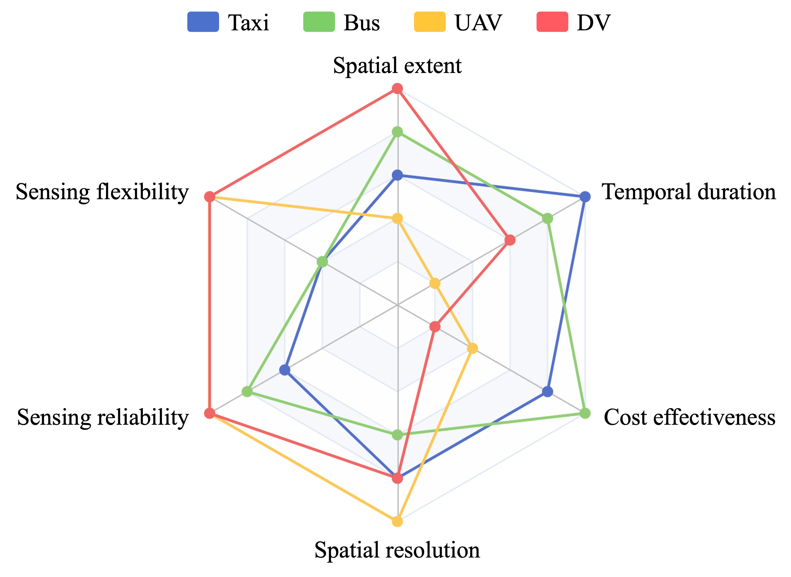
Building on Table LABEL:tabPI, together with some intuition and practical experience, in Figure 2 we qualitatively compare bus, taxi, unmanned aerial vehicles (UAVs) and dedicated vehicles (DVs) in terms of the 6 indicators. In particular,
-
•
Bus fleets excel in spatial extent, temporal duration and cost effectiveness, as buses have routes that extend to remote areas with fixed timetables that boost their temporal duration and sensing reliability.
-
•
Taxi fleets, in addition to cost effectiveness like buses, enjoy superior temporal duration and spatial resolution, as they have very long operating hours as well as flexible routes that cover most urban streets.
-
•
When it comes to costs, both buses and taxis do not require much investment beyond initial installation and regular maintenance. However, in our practical experience, the installation and maintenance fees for taxis are slightly higher because taxis are more revenue-driven and charge more for the time/opportunity lost due to service disruptions.
-
•
Both UAVs and DVs have high sensing flexibility, reliability and resolution, since they are fully controllable to fulfill very specific sensing requirements. However, they are quite costly and require additional human work to control them. Moreover, the mobility of UAVs is typically constrained by limited battery capacity, resulting in low spatial extent and temporal duration.
We consider several applications of drive-by sensing found in the literature, including air quality (Song et al., , 2021), traffic condition (Guo et al., , 2022), heat island phenomena (Fekih et al., , 2021), road surface conditions (Eriksson et al., , 2008), natural/built environment (Rashid et al., , 2020) and on-street parking availability (Mathur et al., , 2010). Table 3 outlines the relative importance of the 6 attributes for each application scenario. Note that the contents of Table 3 are qualitative and for illustration purposes only. Combining Figure 2 with such relative importance renders recommendation for the type of host vehicles, as shown in the last column of Table 3.
| Sensing | Spat. | Sens. | Sens. | Spat. | Cost | Temp. | Suitable |
| scenarios | extent | flex. | rel. | res. | eff. | dur. | fleet |
| Air quality | ✓✓✓ | ✓✓ | ✓✓✓ | Bus, taxi | |||
| Traffic condition | ✓✓ | ✓ | ✓✓✓ | ✓✓✓ | ✓✓✓ | Taxi | |
| Heat island | ✓✓✓ | ✓ | ✓✓ | ✓✓ | Bus, taxi | ||
| Road surface | ✓✓✓ | ✓ | ✓✓✓ | ✓ | DV | ||
| Built environment | ✓ | ✓✓✓ | ✓✓✓ | UAV | |||
| Parking availability | ✓✓ | ✓ | ✓✓✓ | ✓✓ | ✓✓ | ✓✓ | Mixture |
4 Sensor deployment problems in drive-by sensing
As another instance of strategic decision making in drive-by sensing, the sensor deployment problems are widely investigated in the literature. They can be interpreted as non-trivial extensions of the classical facility location problems in the logistics literature (Wang et al., , 2021). This section starts with a conceptual yet general form of the sensor deployment problem, followed by discussion of its applications in sensor allocation for taxis and transit vehicles.
4.1 A conceptual model of sensor deployment
The sensor deployment problem aims to allocate a fixed number of sensors (or budget) to a fleet of vehicles, such that the overall sensing quality is optimized. Two critical components of this problem are:
-
•
The mathematical articulation of sensing quality, which is expressed as a function (functional) of the sensors’ trajectories in space and time (see Section 2 for more details);
-
•
The mobility patterns of the host vehicles, which differ drastically by vehicle type (i.e. taxi, bus, dedicated vehicles, UAVs), and their mathematical expressions as constraints.
We consider a generic form of the sensor deployment problem: assigns sensor to candidate vehicles such that the overall sensing quality is maximized (of course, we assume that each vehicle can be equipped with at most one sensor and, in most cases, ). In the following conceptual model, the decision variables equals 1 if vehicle is equipped with sensor and 0 otherwise. Eqn. (4.6) expresses the sensing quality maximization based on , which denotes vehicle coverage at sub-region . In (4.7), is the sum of coverage by individual sensing vehicles . Eqn (4.8) expresses using a function that encapsulates the mobility pattern of the -th vehicle. For example, if the candidate vehicles are taxis, then the coverage of sub-region by vehicle can be expressed using a probability model following a ball-in-bin approach (O’Keeffe et al., , 2019); for buses, can be determined based on the route information of bus . The sensor limit constraint is expressed in (4.9) and the binary nature of the decision variables are stated in (4.10).
| (4.6) | ||||
| (4.7) | ||||
| (4.8) | ||||
| (4.9) | ||||
| (4.10) |
Remark 4.1.
The binary decision variable ’s are not necessarily associated with individual vehicles. For example, studies on bus-based drive-by sensing (Yu et al., , 2012) consider bus lines and let if the -th line is instrumented with sensors. In this case, the mobility equation reduces to the following incidence variables:
The corresponding optimization problem is also known as the set covering problem (Beasley and Chu, , 1996; Caprara et al., , 1999).
4.2 Sensor deployment problems for taxis
The sensor deployment problem for taxis is typically formulated as a subset selection problem. The premise is that, while taxi trajectories are in general difficult to predict, the mobility patterns of individual taxis might be heterogeneous, depending on the driver’s personal preferences and other unobserved factors. Therefore, by analyzing historical taxi trajectories, one may select a subset of taxis that promise good sensing outcome.
Zhao et al., (2014) propose a vehicle selection mechanism, which determines the minimum number of taxis to achieve coverage requirements. He et al., (2015) propose a greedy approximation algorithm and a genetic algorithm to solve the participant selection problem with a fixed budget to achieve the optimal coverage based on predicted trajectory. Khan et al., (2016) propose an information-centric algorithm to measure the taxis’ relative importance in the network, then presented a selection algorithm to find the best subset of taxis to achieve a desired coverage within a fixed budget. Liu et al., (2016) propose a vehicle selection method that uses heterogeneous vehicle mobility information forecasted by a continuous-time Markov chain for the collection of comprehensive tempo-spatial sensing data. They consider the vehicle selection issue as a knapsack problem and solve it with a polynomial-time greedy approximation algorithm. Yi et al., (2017) designed a greedy approximation algorithm with linear-time complexity to select taxis by minimizing costs while optimizing spatial-temporal coverage. Zhang et al., (2018) modeled the vehicle selection problem as a bi-objective approach, which jointly optimizes the total coverage of all vehicles and the reliability of individual sensing tasks (considering possible non-compliance on part of the drivers). Yu et al., (2021) consider traffic condition monitoring and propose a vehicle selection model based on the spatial-temporal characteristics of the road network, which takes into account the speeds of the host vehicles and their impact on the sensing quality. Chen et al., (2017) postulate a scenario where the sensor can be manually switched on and off, and the sensing cost is proportional to the length of the vehicle trajectory during which the sensor is on. Then, they propose a greedy heuristic to select appropriate trajectory segments to maximize the sensing quality at limited costs.
4.3 Sensor deployment problems for transit vehicles
For overground transit vehicles (e.g. buses, trams), the sensor deployment problem mainly focuses on allocating sensors to transit lines or individual vehicles. Depending on the decision resolution, these studies can be categorized as line selection and vehicle selection.
Regarding line selection, Yu et al., (2012) use a chemical reaction optimization approach to select a subset of bus lines to install sensors. Ali and Dyo, (2017) design a greedy heuristic algorithm to install a limited number of sensors on the bus lines to maximize the total number of segments in road surface condition monitoring. Kaivonen and Ngai, (2020) use an image analysis algorithm to evaluate the percentage of area that can be covered by different bus route combinations. Saukh et al., (2012) designed an evolutionary algorithm to select a subset of tram lines based on the service timetables to achieve good coverage with data calibration constraints (see Section 6.2).
Regarding vehicle selection, Gao et al., (2016) and Wang et al., (2018) design a greedy and an approximate algorithms, respectively, to select a subset of buses to maximize the coverage utility. Tonekaboni et al., (2020) design a heuristic algorithm to allocate a limited number of sensors to buses considering the importance level of different geographical regions in monitoring the urban heat island phenomenon. Agarwal et al., (2020) aim to select a subset of vehicles from a hybrid fleet of buses and taxis to maximize the spatial-temporal coverage of the city. They formulated this problem as an integer linear programming model and designed an approximate algorithm to solve it.
Different from the aforementioned models, Ji et al., (2023) adopt a trip-based approach, which explicitly consider timetabled trips that must be fulfilled by the bus fleet while a portion of them perform sensing tasks. To address the computational challenge in large-scale instances, the authors design a multi-stage solution framework that decouples the spatial-temporal structures of the sensing task through line pre-selection and bi-level optimization. As a result, the computational complexity is reduced to be sub-linear w.r.t. the number of lines, rather than combinatorial w.r.t. the number of buses in existing vehicle selection approaches.
4.4 Synopsis
Table 4 summarizes relevant literature on the sensor location problem for various vehicle types. They all focused on allocating sensors to vehicles or bus/tram lines based on actual or predicted vehicle trajectories and employ heuristic, meta-heuristic, or approximate algorithms to solve the problem. It is noted that all these studies fall within the category of opportunistic sensing (Ma et al., , 2014; Lane et al., , 2008).
| Study | Dataset | Sensor host | Solution approach |
| Zhao et al., (2014) | GPS trajectories of 10,357 taxis in Beijing, China | Taxi | Greedy heuristic algorithm |
| He et al., (2015) | Taxi trajectory data in Cologne, Germany | Taxi | Greedy approximation algorithm and genetic algorithm |
| Khan et al., (2016) | Taxi trajectory data in Cologne, Germany | Taxi | Greedy heuristic algorithm |
| Liu et al., (2016) | GPS trajectories of 10,357 taxis in Beijing, China | Taxi | Greedy approximation algorithm |
| Yi et al., (2017) | GPS trajectories of 4,316 taxis in Shanghai, China | Taxi | Greedy approximation algorithm |
| Zhang et al., (2018) | GPS trajectories of 10,357 taxis in Beijing, China | Taxi | Greedy heuristic and multi-objective genetic algorithm (NSGA-II) |
| Yu et al., (2021) | Taxi trajectories in Cologne, Germany | Taxi | Greedy heuristic algorithm |
| Chen et al., (2017) | Taxi trajectories in Rome, Italy | Taxi | Greedy heuristic algorithm |
| Yu et al., (2012) | 91 bus lines in Hong Kong Island, China | Bus line | Chemical Reaction Optimization (meta-heuristic) |
| Ali and Dyo, (2017) | 713 bus lines in London, UK | Bus line | Greedy heuristic algorithm |
| Kaivonen and Ngai, (2020) | 21 bus lines in Uppsala, Sweden | Bus line | Image analysis algorithm |
| Gao et al., (2016) | Trajectories of 1415 buses in Hangzhou, China | Bus | Greedy heuristic algorithm |
| Wang et al., (2018) | Bus trajectories in Beijing, China | Bus | Greedy approximate algorithm |
| Tonekaboni et al., (2020) | Trajectories of 20 buses in Athens, Georgia | Bus | Greedy heuristic algorithm |
| Saukh et al., (2012) | 13 tram lines in Zurich, Switzerland | Tram line | Evolutionary algorithm |
| Agarwal et al., (2020) | Taxi and bus trajectories in San Francisco, USA | Taxi & bus | Approximation algorithm |
| Ji et al., (2023) | Timetables of 167 bus lines in Chengdu, China | Bus trips | Multi-stage solution algorithm |
5 Operational intervention in drive-by sensing
Instead of opportunistic sensing, which exerts no influence on the operations of the host vehicles, another line of research investigates the possibility of improving sensing quality by applying intervention measures, ranging from incentivizing schemes to active scheduling. The design of such interventions is highly dependent on the nature of the host fleet, i.e. institutional barriers, operational constraints, participant compliance, and cost-effectiveness.
5.1 Intervention on taxi operations
Taxi-based drive-by sensing is associated with relatively low costs and high temporal duration (Figure 2), but its spatial survey is usually biased, primarily driven by factors such as spatially heterogeneous trip requests, and the tendency to follow shortest/popular paths. To improve the spatial coverage of taxi fleets while maintaining a satisfactory level of service, studies have resorted to incentivizing mechanisms and routing maneuvers.
5.1.1 Incentivizing mechanism
Fan et al., 2021a propose a system that integrates vehicle scheduling and incentive mechanisms to complete the sensing tasks with minimum cost. First, they formulate the sensing vehicle scheduling problem into an augmented set cover problem with spatial-temporal constraints by generating a driver’s candidate trajectory set within an acceptable detour range when the origin-destination pair set is known. Then, they design a greedy algorithm to choose routes for vehicles and design a pricing algorithm based on reverse combinatorial auction to calculate the drivers’ rewards. Chen et al., (2020) focus on routing advice for vacant taxis with limited incentive budget, by proposing a greedy heuristic algorithm that selects appropriate subset of vacant taxis to incentivize, along with suggested routes, such that they contribute to the maximization of sensing quality with limited monetary incentives, which are estimated based on predicted deadhead trips and trip requests. A similar incentive mechanism is discussed in Xu et al., (2019), where the sensing quality maximization is replaced by minimization of the discrepancy between actual and target distribution of sensing rewards.
5.1.2 Routing maneuvers
One of the causes of unbalanced spatial survey afforded by taxi fleets is their tendency to follow shortest (or least costly) paths between origins and destinations, which often leads to overly concentrated coverage of certain main street segments, leaving others rarely visited. Studies have therefore investigated diversified routing choices following both decentralized and centralized decision architectures. Asprone et al., (2021) propose an -perturbed route set based on the A∗ algorithm, such that a trip with given origin and destination can be executed by following a route that contributes to greater sensing coverage without considerably deviating from the optimal routing choice. Masutani, (2015) consider a centralized decision framework where a traffic center collects information of planned routes of all relevant vehicles, and makes routing recommendations to all participants based on a sensing quality maximization procedure. Simulation results show that this method can harvest higher-coverage sensing data without extending vehicles’ travel times. Guo and Qian, (2022) focus on the vacant cruising phase of taxi services, by devising a routing guidance framework for unoccupied taxis. The effectiveness of this method in boosting the sensing efficacy is demonstrated via a simulation study of ride-hailing fleet in New York.
5.2 Intervention on bus operations
Literature on the intervention of bus operations is sparse. Dai and Han, (2023) explore the sensing power of bus fleet by investigating the possibility of flexible sensor circulation in a transit network enabled by inter-line bus scheduling. They consider a fleet of normal and instrumented buses, and aim to maximize the sensing quality while minimizing bus operational costs (especially pertaining to inter-line relocations), while making sure that all timetabled trips are served at no cost of the service quality. This problem is formulated as a nonlinear integer program based on time-expanded network representation of the bus transit system (Lu et al., , 2022), which is solved by a batching scheduling heuristic algorithm. Using the bus network in Chengdu as a case study, the authors show that inter-line scheduling can improve the sensing quality by up to 32.1% while slightly saving the operational cost. They further point out that sensor investment can be reduced by over 33% when considering active bus scheduling. Ji et al., (2023) present a trip-based sensor allocation problem, which explicitly considers timetabled trips that must be executed by the fleet while a portion of them perform sensing tasks. To address the computational challenge in large-scale instances, we design a multi-stage solution frame- work that decouples the spatial-temporal structures of the sensing task through line pre- selection and bi-level optimization. As a result, the computational complexity is reduced to be sub-linear w.r.t. the number of lines, rather than combinatorial w.r.t. the number of buses in existing vehicle-based approaches. A real-world case study in central Chengdu demonstrates that coordinating bus scheduling and sensing tasks can substantially increase the spatial-temporal sensing coverage.
5.3 Dedicated vehicles (DVs)
Dedicated sensing vehicles are suitable to (1) survey targeted areas for their high controllability, and (2) spatially and temporally complement the sensing of other fleet types. O’Keeffe et al., (2019) proposed an idea of hybrid monitoring, where taxis are used to scan popular areas of a city, and hard-to-reach areas could be covered by dedicated vehicles. Fan et al., 2021b further realized such an idea by proposing a repositioning policy for DVs to achieve fine-grained spatial-temporal sensing coverage at the minimum long-term operational cost. Considering the randomness of taxi trajectories, they adopt a robust optimization approach for the DV scheduling problem. Tang et al., (2021) design two real-time routing algorithms for a fleet of DVs based on multi-agent reinforcement learning. This approach is shown to significantly outperform heuristic random routing policies, and could be applied to a mixed fleet by complementing the coverage offered by taxis or buses, based on their real-time trajectory information. Ji et al., (2023) design an adaptive large neighborhood search algorithm and a bilevel matheuristic method to solve the DV-based Volatile Organic Compounds (VOCs) monitoring, the results show that DVs can be flexibly navigated to monitor a set of points of interest with arbitrary sensing weights.
5.4 Unmanned Aerial Vehicles (UAVs)
The increased availability and readiness of general air mobility such as UAVs have raised their promises in urban sensing (Lambey and Prasad, , 2021). The advantages of UAV-based urban sensing include high controllability, which makes it suitable for targeted survey, and high mobility, which removes the physical constraint of street layouts.
Zhou et al., (2018) consider a joint routing and area assignment problem in UAV-aided sensing, as a two-stage two-sided matching problem. The first stage divides the target area into sub-regions and design UAV routes using dynamic programming and genetic algorithm; the second stage assigns UAVs to the routes. Xu et al., (2021) solve an urban sensing task allocation problem for UAVs, with heterogenous task requirements as input, using three heuristic algorithms to minimize the sensing cost. Ding et al., (2021) integrate community sensing with UAV-based sensing, and design an actor-centric heterogenous collaborative reinforcement learning algorithm to schedule different UAV sensors to maximize sensing coverage, coverage fairness and cost effectiveness. Xiang et al., (2021) consider a scenario where UAVs are used for logistic delivery while simultaneously for urban sensing. The problem jointly determines package assignment, delivery routes and sensing windows to optimize delivery and sensing objectives, which is solved with an approximate algorithm. Trotta et al., (2018) propose a framework that allows UAVs to perform city-scale video monitoring of a set of Points of Interests (PoIs). They develop a mixed integer linear programming model to select the UAVs for periodic re-charging and repositioning by landing on buses.
6 Relevant considerations for research and practice
6.1 Drive-by sensing with spatial-temporal correlation of information
Most studies that attempt to quantify the sensing quality using various metrics have not considered subsequent data-driven modeling or analyses that would benefit from such crowdsourced information. For example, in air quality sensing, mobile measurements of PM2.5 concentrations were used alongside fixed-location measurements for spatial inference based on urban big data (Song et al., , 2021). In traffic state monitoring, information such as flow and speed on unvisited links is likely to be inferred (sometimes with remarkable accuracy) from data collected in neighboring links or nodes (Zhu et al., , 2022; Viti et al., , 2014; Xu et al., , 2016). A few studies (Ding et al., , 2021; Guo and Qian, , 2022) have considered the effect of spatial and temporal correlation of measurements in mobile sensing, by postulating that measurements collected at certain point in space and time can be used to infer its neighbors.
The significance of spatial or temporal inference, as undertaken in the aforementioned studies, is that it could change the way sensing coverage is evaluated. Integrating application-specific objectives or constraints would be an interesting and practical extension of urban drive-by sensing.
6.2 Data calibration
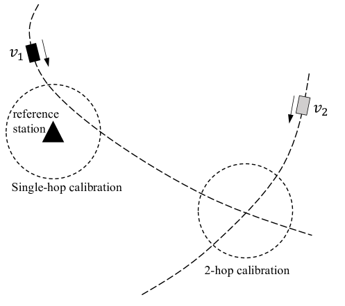
In drive-by sensing, the accuracy and reliability of the data collected by mobile sensors is crucial for their intended application. To ensure satisfactory accuracy and consistency of the measurements, some mobile sensors need to be constantly calibrated by fixed reference stations via collocation (Saukh et al., , 2014; Maag et al., , 2017; Song et al., , 2021). This means that two sensors are placed in proximity in the space-time domain, and the measurement of one (the reference station) can be used to correct the other.
Mobile data calibration via collocation can be categorized as single and multi hop (Hasenfratz et al., , 2012; Fu et al., , 2017) as shown in Figure 3. Single-hop calibration forms a data checkpoint when the vehicle is near the reference station , while a 2-hop calibration took place if a calibration path exists starting from the reference station and the vehicle . The cases of k-hop calibration can be similarly defined.
Agarwal et al., (2020) and Saukh et al., (2012) consider the need for data calibration as a constraint in mobile sensor deployment problems. Another way to address this issue is through the objective function, by either penalizing under-calibrated instances at the expense of non-analytic formulation, or increasing the spatial weight in (2.2) such that more vehicle trips are concentrated where the reference station is located, but without a guarantee that all sensors are uniformly calibrated.
6.3 Sensor deployment with heterogenous mobility patterns
The distinct mobility patterns of different types of host vehicles are responsible for their unique capabilities, as well as shortcomings, in certain aspect of drive-by sensing, as illustrated in Figure 2. An issue that has not been systematically explored is the sensing efficacy of a mixed vehicle fleet (e.g. that consisting of taxis, buses and dedicated vehicles). Depending on the level of operational intervention on the host fleet, this issue can be approached as
- (1)
-
(2)
A (partial) operational intervention problem, which aims to maneuver certain types of vehicles to complement the opportunistic sensing offered by other fleets.
While a few studies (Fan et al., 2021b, ; Agarwal et al., , 2020) have considered more than one type of vehicles in the sensing fleet, limited insights are generated regarding the applicability and limitations of such combinations in general, which is worth of further and thorough investigation.
7 Conclusion and outlook
Urban drive-by sensing (DS) is an emerging data collection paradigm that leverages vehicle mobilities to perform pervasive sensing at low costs. DS has been seen in numerous smart city applications such as air quality sensing, traffic state monitoring, waster disposal surveillance, and disaster response. For a given urban sensing application with certain budget, the ideal distribution of the sensors in a space-time domain is usually difficult to achieve in reality, due to the physical constraints imposed by the mobility patterns of the host vehicles. Therefore, the essential purpose of optimization, whether regarding fleet selection, sensor allocation, or vehicle maneuver, is to remove those constraints such that the resulting sensing efficacy is engineered towards optimality.
Building on a thorough review of existing literature, this paper has addressed the following questions in detail:
-
Q1.
quantifying sensing quality;
-
Q2.
assessing the sensing capabilities of various fleet types;
-
Q3.
sensor deployment (allocation) optimization;
-
Q4.
operations of sensing vehicles.
While literature in these regards keep expanding, a few practical issues should be noted:
-
1.
There does not seem to be an agreement on what is the best method to assess sensing quality, even for a given DS application such as air quality sensing. In fact, such an agreement is unlikely to exist since the goodness of a given sensing coverage is dependent on numerous factors, including but not limited to: sensor specification, data quality control standards, subsequent use of the sensing data, and user-defined sensing priority.
-
2.
There are certain constraints when it comes to mounting sensors on vehicles. Relevant considerations include: power supply (which renders some electric vehicles unsuitable for safety reasons), physical configuration (large sensors cannot be installed without affecting vehicle operation), and vehicle modification (such as electric wires and gas tubes). These and similar constraints need to be contemplated when evaluating the suitability of vehicle fleets for carrying out certain DS tasks.
-
3.
For third-party vehicles such as taxis and buses, incentivizing schemes or scheduling attempts need to carefully address the potential impact on their operations. While studies have proposed monetary incentives in various scenarios (Zhang et al., , 2016), it is unclear how they pan out on a human behavior level. User privacy is another important aspect of passive sensing that needs to be addressed in future research.
In summary, urban drive-by sensing is a promising means of collecting crowdsourced sensing data at relatively low costs. In the development and adoption of DS systems, optimization will keep playing an important role to fully harness their potentials. The inherent transport component, and its relevance to logistics and mechanism design (Rifki et al., , 2020; Lu et al., , 2022), suggest that the development of DS can further benefit from the participation of transportation and operations research communities.
Acknowledgement
This work is supported by the National Natural Science Foundation of China through grants 72071163 and 72271206, and the Natural Science Foundation of Sichuan Province through grant 2022NSFSC0474.
References
- Agarwal et al., (2020) Agarwal, D. , Iyengar, S. , Swaminathan, M. , Sharma, E. , Raj, A. , Hatwar, A., 2020. Modulo: Drive-by Sensing at City-scale on the Cheap, in: Proceedings of the 3rd ACM SIGCAS Conference on Computing and Sustainable Societies. Ecuador, 187-197.
- Ali and Dyo, (2017) Ali, J., Dyo, V., 2017. Coverage and Mobile Sensor Placement for Vehicles on Predetermined Routes: A Greedy Heuristic Approach, in: Proceedings of the 14th International Joint Conference on e-Business and Telecommunications. Madrid, Spain, 83-88.
- Alsina-Pagés et al., (2017) Alsina-Pagés, R., Hernandez-Jayo, U., Alías, F., Angulo, I., 2017. Design of a Mobile Low-Cost Sensor Network Using Urban Buses for Real-Time Ubiquitous Noise Monitoring. Sensors 17 (1), 57.
- Anjomshoaa et al., (2018) Anjomshoaa, A., Duarte, F., Rennings, D., Matarazzo, T.J., deSouza, P., Ratti, C., 2018. City Scanner: Building and Scheduling a Mobile Sensing Platform for Smart City Services. IEEE Internet of Things Journal 5 (6), 4567-4579.
- Asprone et al., (2021) Asprone, D., Di Martino, S., Festa, P., Starace, L.L.L., 2021. Vehicular crowd-sensing: a parametric routing algorithm to increase spatio-temporal road network coverage. International Journal of Geographical Information Science 35 (9), 1876-1904.
- Beasley and Chu, (1996) Beasley, J.E., Chu, P.C., 1996. A genetic algorithm for the set covering problem. European Journal of Operational Research 94 (2), 392-404.
- Bock et al., (2017) Bock, F., Attanasio, Y., Di Martino, S., 2017. Spatio-Temporal Road Coverage of Probe Vehicles: A Case Study on Crowd-Sensing of Parking Availability with Taxis. in: Societal Geo-Innovation, edited by Arnold Bregt, Tapani Sarjakoski, Ron van Lammeren, and Frans Rip, PP. 165–184.
- Bonola et al., (2016) Bonola, M., Bracciale, L., Loreti, P., Amici, R., Rabuffi, A., Bianchi, G., 2016. Opportunistic communication in smart city: Experimental insight with small-scale taxi fleets as data carriers. Ad Hoc Networks 43, 43-55.
- Capponi et al., (2019) Capponi, A., Fiandrino, C., Kantarci, B., Foschini, L., Kliazovich, D., Bouvry, P., 2019. A Survey on Mobile Crowdsensing Systems: Challenges, Solutions, and Opportunities. IEEE Communications Surveys & Tutorials. 21, 2419-2465.
- Caprara et al., (1999) Caprara, A., Fischetti, M., Toth, P., 1999. A Heuristic Method for the Set Covering Problem. Operations Research 47 (5), 730-743.
- Chan, (2021) Chan, V.W.S., 2021. Internet of Things and Smart Cities. IEEE Communications Magazine 59 (10), 4-6.
- Chen et al., (2020) Chen, X., Xu, S., Han, J., Fu, H., Pi, X., Joe-Wong, C., Li, Y., Zhang, L., Noh, H.Y., Zhang, P., 2020. PAS: Prediction-Based Actuation System for City-Scale Ridesharing Vehicular Mobile Crowdsensing. IEEE Internet of Things Journal 7 (5), 3719-3734.
- Chen et al., (2017) Chen, Y., Lv, P., Guo, D., Zhou, T., Xu, M., 2017. Trajectory segment selection with limited budget in mobile crowd sensing. Pervasive and Mobile Computing 40, 123-138.
- Cruz Caminha et al., (2018) Cruz Caminha, P., de Souza Couto, R., Maciel Kosmalski Costa, L., Fladenmuller, A., Dias de Amorim, M., 2018. On the Coverage of Bus-Based Mobile Sensing. Sensors 18 (6), 1976.
- (15) Cruz, P., Couto, R.S., Costa, L.H.M.K., Fladenmuller, A., Dias de Amorim, M., 2020a. A delay-aware coverage metric for bus-based sensor networks. Computer Communications 156, 192-200.
- (16) Cruz, P., Couto, R.S., Costa, L.H.M.K., Fladenmuller, A., de Amorim, M.D., 2020b. Per-Vehicle Coverage in a Bus-Based General-Purpose Sensor Network. IEEE Wireless Communications Letters 9 (7), 1019-1022.
- Dai and Han, (2023) Dai, Z., Han, K., 2023. Exploring the drive-by sensing power of bus fleet through active scheduling. Transportation Research Part E: Logistics and Transportation Review 171, 103029.
- deSouza et al., (2020) deSouza, P., Anjomshoaa, A., Duarte, F., Kahn, R., Kumar, P., Ratti, C., 2020. Air quality monitoring using mobile low-cost sensors mounted on trash-trucks: Methods development and lessons learned. Sustainable Cities and Society 60, 102239.
- Ding et al., (2021) Ding, L., Zhao, D., Cao, M., Ma, H., 2021. When Crowdsourcing Meets Unmanned Vehicles: Toward Cost-Effective Collaborative Urban Sensing via Deep Reinforcement Learning. IEEE Internet of Things Journal 8 (15), 12150-12162.
- Du et al., (2019) Du, R., Santi, P., Xiao, M., Vasilakos, A.V., Fischione, C., 2019. The Sensable City: A Survey on the Deployment and Management for Smart City Monitoring. IEEE Communications Surveys & Tutorials 21 (2), 1533-1560.
- Duan et al., (2014) Duan, L., Kubo, T., Sugiyama, K., Huang, J., Hasegawa, T., Walrand, J., 2014. Walrand, Motivating Smartphone Collaboration in Data Acquisition and Distributed Computing. IEEE Transactions on Mobile Computing 13 (10), 2320-2333.
- Eriksson et al., (2008) Eriksson, J., Girod, L., Hull, B., Newton, R., Madden, S., Balakrishnan, H., 2008. The pothole patrol: using a mobile sensor network for road surface monitoring. in: Proceeding of the 6th international conference on Mobile systems, applications, and services - MobiSys ’08, New York, NY, USA, 29-39.
- (23) Fan, G., Jin, H., Liu, Q., Qin, W., Gan, X., Long, H., Fu, L., Wang, X., 2021a. Joint Scheduling and Incentive Mechanism for Spatio-Temporal Vehicular Crowd Sensing. IEEE Transactions on Mobile Computing 20 (4), 1449-1464.
- (24) Fan, G., Zhao, Y., Guo, Z., Jin, H., Gan, X., Wang, X., 2021b. Towards Fine-Grained Spatio-Temporal Coverage for Vehicular Urban Sensing Systems. in: IEEE INFOCOM 2021 - IEEE Conference on Computer Communications, IEEE, Vancouver, BC, Canada, 1-10.
- Fekih et al., (2021) Fekih, M.A., Bechkit, W., Rivano, H., Dahan, M., Renard, F., Alonso, L., Pineau, F., 2021. Participatory Air Quality and Urban Heat Islands Monitoring System. IEEE Transactions on Instrumentation and Measurement 70, 1-14.
- Fu et al., (2017) Fu, K., Ren, W., Dong, W., 2017. Multihop calibration for mobile sensing: K-hop Calibratability and reference sensor deployment. in: IEEE INFOCOM 2017 - IEEE Conference on Computer Communications, Atlanta, GA, USA, 1-9.
- Ganti et al., (2011) Ganti, R., Ye, F., Lei, H., 2011. Mobile crowdsensing: current state and future challenges. IEEE Communications Magazine 49 (11), 32-39.
- Gao et al., (2016) Gao, Y., Dong, W., Guo, K., Liu, Xue, Chen, Y., Liu, Xiaojin, Bu, J., Chen, C., 2016. Mosaic: A low-cost mobile sensing system for urban air quality monitoring. in: IEEE INFOCOM 2016 - The 35th Annual IEEE International Conference on Computer Communications, San Francisco, CA, USA, 1-9.
- Guan et al., (2016) Guan, G., Chen, Y., Guo, K., Gao, Y., Dong, W., 2016. Low-cost urban air quality monitoring with Mosaic. in: Conference on Computer Communications Workshops (INFOCOM WKSHPS), 642-643.
- Guo and Qian, (2022) Guo, S., Qian, X., 2022. Optimal sensing of urban road networks with large-scale ridesourcing vehicles, arXiv. http://arxiv.org/abs/2207.11285.
- Guo et al., (2022) Guo, S., Qian, X., Dasgupta, S., Rahman, M., Jones, S., 2022. Sensing and monitoring of urban roadway traffic state with large-scale ride-sourcing vehicles. in: The Rise of Smart Cities. 551-582.
- Hasenfratz et al., (2012) Hasenfratz, D., Saukh, O., Thiele, L., 2012. On-the-fly calibration of low-cost gas sensors. in: Wireless Sensor Networks, edited by Gian Pietro Picco and Wendi Heinzelman, PP. 228-244.
- Hasenfratz et al., (2015) Hasenfratz, D., Saukh, O., Walser, C., Hueglin, C., Fierz, M., Arn, T., Beutel, J., Thiele, L., 2015. Deriving high-resolution urban air pollution maps using mobile sensor nodes. Pervasive and Mobile Computing 16, 268-285.
- He et al., (2015) He, Z., Cao, J., Liu, X., 2015. High quality participant recruitment in vehicle-based crowdsourcing using predictable mobility. in: 2015 IEEE Conference on Computer Communications (INFOCOM), Kowloon, Hong Kong, 2542-2550.
- Hemamalini et al., (2022) Hemamalini, R. R., Vinodhini, R., Shanthini, B., Partheeban, P., Charumathy, M., Cornelius, K., 2022. Air quality monitoring and forecasting using smart drones and recurrent neural network for sustainable development in Chennai city. Sustainable Cities and Society, 85, 104077.
- Honicky et al., (2008) Honicky, R., Brewer, E.A., Paulos, E., White, R., 2008. N-smarts: networked suite of mobile atmospheric real-time sensors. in: Proceedings of the second ACM SIGCOMM workshop on Networked systems for developing regions - NSDR ’08, Seattle, WA, USA, 25.
- Hu et al., (2019) Hu, Z., Bai, Z., Yang, Y., Zheng, Z., Bian, K., Song, L., 2019. UAV Aided Aerial-Ground IoT for Air Quality Sensing in Smart City: Architecture, Technologies, and Implementation. IEEE Network 33 (2), 14-22.
- Ji, (2021) Ji, W., 2021. Route planning for dedicated vehicles in urban drive-by sensing. BSc dissertation, Southwest Jiaotong University.
- Ji et al., (2022) Ji,W., Liu, T., Han, K., 2022. Exploring the sensing power of bus fleet-based drive-by sensing. in: Proceedings of the 26th International Conference of Hong Kong Society for Transportation Studies.
- Ji et al., (2023) Ji, W., Han, K., Ge, Q., 2023. Extended team orienteering problem: Algorithms and applications, arXiv: 2307.02397.
- Ji et al., (2023) Ji, W., Han, K., Liu, T., 2023. Trip-based mobile sensor deployment for drive-by sensing with bus fleets, arXiv: 2302.11489.
- Jiang et al., (2011) Jiang, Y., Shang, L., Li, K., Tian, L., Piedrahita, R., Yun, X., Mansata, O., Lv, Q., Dick, R.P., Hannigan, M., 2011. MAQS: a personalized mobile sensing system for indoor air quality monitoring. in: Proceedings of the 13th international conference on Ubiquitous computing - UbiComp ’11. Beijing, China, 271.
- Kaivonen and Ngai, (2020) Kaivonen, S., Ngai, E.C.-H., 2020. Real-time air pollution monitoring with sensors on city bus. Digital Communications and Networks 6 (1), 23-30.
- Kang et al., (2016) Kang, L., Poslad, S., Wang, W., Li, X., Zhang, Y., Wang, C., 2016. A Public Transport Bus as a Flexible Mobile Smart Environment Sensing Platform for IoT. in: 2016 12th International Conference on Intelligent Environments (IE). London, United Kingdom, 1-8.
- Khan et al., (2016) Khan, J.A., Ghamri-Doudane, Y., Botvich, D., 2016. Autonomous Identification and Optimal Selection of Popular Smart Vehicles for Urban Sensing - An Information-Centric Approach. IEEE Transactions on Vehicular Technology 65 (12), 9529-9541.
- Kullback and Leibler, (1951) Kullback, S., Leibler, R.A., 1951. On information and sufficiency. The annals of mathematical statistics 22 (1), 79-86.
- Kumar et al., (2015) Kumar, P., Morawska, L., Martani, C., Biskos, G., Neophytou, M., Di Sabatino, S., Bell, M., Norford, L., Britter, R., 2015. The rise of low-cost sensing for managing air pollution in cities. Environment International. 75, 199-205
- Lambey and Prasad, (2021) Lambey, V., Prasad, A.D., 2021. A Review on Air Quality Measurement Using an Unmanned Aerial Vehicle. Water, Air, & Soil Pollution 232 (3), 109.
- Laport-López et al., (2020) Laport-López, F., Serrano, E., Bajo, J., Campbell, A.T., 2020. A review of mobile sensing systems, applications, and opportunities. Knowledge and Information Systems. 62, 145–174.
- Lee and Gerla, (2010) Lee, U., Gerla, M., 2010. A survey of urban vehicular sensing platforms. Computer Networks. 54, 527-544.
- Li et al., (2022) Li, C., Liu, M., Hu, Y., Wang, H., Xiong, Z., Wu, W., Liu, C., Zhang, C., Du, Y., 2022. Investigating the vertical distribution patterns of urban air pollution based on unmanned aerial vehicle gradient monitoring. Sustainable Cities and Society, 86, 104144.
- Li et al., (2009) Li, X., Shu, W., Li, M., Huang, H., Luo, P., Wu, M., 2009. Performance Evaluation of Vehicle-Based Mobile Sensor Networks for Traffic Monitoring. IEEE Transactions on Vehicular Technology 58 (4), 1647-1653.
- Liu et al., (2005) Liu, B., Brass, P., Dousse, O., Nain, P., Towsley, D., 2005. Mobility improves coverage of sensor networks. in: Proceedings of the 6th ACM international symposium on Mobile ad hoc networking and computing - MobiHoc ’05. New York, NY, USA, 300-308.
- Liu et al., (2016) Liu, J., Shen, H., Zhang, X., 2016. A Survey of Mobile Crowdsensing Techniques: A Critical Component for the Internet of Things. in: Proceeding of 2016 25th International Conference on Computer Communication and Networks (ICCCN). Waikoloa, HI, USA, 1-6.
- Liu et al., (2016) Liu, Y., Niu, J., Liu, X., 2016. Comprehensive tempo-spatial data collection in crowd sensing using a heterogeneous sensing vehicle selection method. Personal and Ubiquitous Computing 20 (3), 397-411.
- Lane et al., (2008) Lane, N.D., Eisenman, S.B., Musolesi, M., Miluzzo, E., Campbell, A.T., 2008. Urban sensing systems: opportunistic or participatory ?, in: Proceedings of the 9th workshop on Mobile computing systems and applications - HotMobile ’08. Napa Valley, California, 11.
- Lu et al., (2022) Lu, C., Diabat, A., Li, Y., Yang, Y., 2022. Combined passenger and parcel transportation using a mixed fleet of electric and gasoline vehicles. Transportation Research Part E: Logistics and Transportation Review, 157:102546.
- Ma et al., (2014) Ma, H., Zhao, D., Yuan, P., 2014. Opportunities in mobile crowd sensing. IEEE Communications Magazine 52 (8), 29-35.
- Maag et al., (2017) Maag, B., Zhou, Z., Saukh, O., Thiele, L., 2017. SCAN: Multi-hop calibration for mobile sensor arrays. in: Proceedings of the ACM on Interactive, Mobile, Wearable and Ubiquitous Technologies, 19.
- Mahajan et al., (2021) Mahajan, S., Luo, C. H., Wu, D. Y., Chen, L. J., 2021. From Do-It-Yourself (DIY) to Do-It-Together (DIT): Reflections on designing a citizen-driven air quality monitoring framework in Taiwan. Sustainable Cities and Society, 66, 102628.
- Malekjafarian et al., (2022) Malekjafarian, A., Corbally, R., Gong, W., 2022. A review of mobile sensing of bridges using moving vehicles: Progress to date, challenges and future trends. Structures. 44, 1466-1489.
- Marjovi et al., (2015) Marjovi, A., Arfire, A., Martinoli, A., 2015. High Resolution Air Pollution Maps in Urban Environments Using Mobile Sensor Networks, in: 2015 International Conference on Distributed Computing in Sensor Systems. Fortaleza, Brazil, 11–20.
- Martino and Lucio Starace, (2022) Martino, S.D., Lucio Starace, L.L., 2022. Vehicular Crowd-Sensing on Complex Urban Road Networks: A Case Study in the City of Porto. Transportation Research Procedia 62, 350-357.
- Masutani, (2015) Masutani, O., 2015. A sensing coverage analysis of a route control method for vehicular crowd sensing. in: 2015 IEEE International Conference on Pervasive Computing and Communication Workshops (PerCom Workshops). St. Louis, MO, 396-401.
- Mathur et al., (2010) Mathur, S., Jin, T., Kasturirangan, N., Chandrasekaran, J., Xue, W., Gruteser, M., Trappe, W., 2010. ParkNet: drive-by sensing of road-side parking statistics. in: Proceedings of the 8th international conference on Mobile systems, applications, and services - MobiSys ’10. San Francisco, California, USA, 123.
- Messier et al., (2018) Messier, K.P., Chambliss, S.E., Gani, S., Alvarez, R., Brauer, M., Choi, J.J., Hamburg, S.P., Kerckhoffs, J., LaFranchi, B., Lunden, M.M., Marshall, J.D., Portier, C.J., Roy, A., Szpiro, A.A., Vermeulen, R.C.H., Apte, J.S., 2018. Mapping Air Pollution with Google Street View Cars: Efficient Approaches with Mobile Monitoring and Land Use Regression. Environmental Science & Technology 52 (21), 12563-12572.
- O’Keeffe et al., (2019) O’Keeffe, K.P., Anjomshoaa, A., Strogatz, S.H., Santi, P., Ratti, C., 2019. Quantifying the sensing power of vehicle fleets. Proceedings of the National Academy of Sciences 116 (26), 12752–12757.
- Pasqualetti et al., (2012) Pasqualetti, F., Durham, J.W., Bullo, F., 2012. Cooperative Patrolling via Weighted Tours: Performance Analysis and Distributed Algorithms. IEEE Transactions on Robotics 28 (5), 1181-1188.
- Perera et al., (2014) Perera, C., Zaslavsky, A., Christen, P., Georgakopoulos, D., 2014. Sensing as a service model for smart cities supported by Internet of Things. Transactions on Emerging Telecommunications Technologies 25 (1), 81-93.
- Rashid et al., (2020) Rashid, M.T., Zhang, D.Y., Wang, D., 2020. SocialDrone: An Integrated Social Media and Drone Sensing System for Reliable Disaster Response. in: IEEE INFOCOM 2020 - IEEE Conference on Computer Communications. Toronto, ON, Canada, 218-227.
- Restuccia et al., (2017) Restuccia, F., Ghosh, N., Bhattacharjee, S., Das, S.K., Melodia, T., 2017. Quality of Information in Mobile Crowdsensing: Survey and Research Challenges. ACM Transactions on Sensor Networks 13 (4), 1-43.
- Rifki et al., (2020) Rifki, O., Chiabaut, N., Solnon, R., 2020. On the impact of spatio-temporal granularity of traffic conditions on the quality of pickup and delivery optimal tours. Transportation Research Part E: Logistics and Transportation Review, 142:102085.
- Sanchez et al., (2014) Sanchez, L., Muñoz, L., Galache, J.A., Sotres, P., Santana, J.R., Gutierrez, V., Ramdhany, R., Gluhak, A., Krco, S., Theodoridis, E., Pfisterer, D., 2014. SmartSantander: IoT experimentation over a smart city testbed. Computer Networks 61, 217–238.
- Saukh et al., (2012) Saukh, O., Hasenfratz, D., Thiele, L., 2012. Route selection for mobile sensor nodes on public transport networks. Journal of Ambient Intelligence and Humanized Computing 5 (3), 307-321.
- Saukh et al., (2014) Saukh, O., Hasenfratz, D., Walser, C., Thiele, L., 2014. On rendezvous in mobile sensing networks. Lecture Notes in Electrical Engineering 281, 29-42.
- Singh et al., (2020) Singh, P., Kaur, A., Kumar, N., 2020. A reliable and cost-efficient code dissemination scheme for smart sensing devices with mobile vehicles in smart cities. Sustainable Cities and Society, 62, 102374.
- SM et al., (2019) SM, S. N., Yasa, P. R., Narayana, M. V., Khadirnaikar, S., Rani, P., 2019. Mobile monitoring of air pollution using low cost sensors to visualize spatio-temporal variation of pollutants at urban hotspots. Sustainable Cities and Society, 44, 520-535.
- Song et al., (2021) Song, J., Han, K., Stettler, M.E.J., 2021. Deep-MAPS: Machine learning based mobile air pollution sensing. IEEE Internet of Things Journal 8 (9), 7649-7660.
- Tang et al., (2021) Tang, B., Li, Z., Han, K., 2021. Multi-agent reinforcement learning for Mobile crowdsensing systems with dedicated vehicles on road networks. in: IEEE Intelligent Transportation Systems Conference, Indianapolis, USA, Sep 19-21.
- Tonekaboni et al., (2020) Tonekaboni, N.H., Ramaswamy, L., Mishra, D., Setayeshfar, O., Omidvar, S., 2020. Spatio-Temporal Coverage Enhancement in Drive-By Sensing Through Utility-Aware Mobile Agent Selection. in: Internet of Things - ICIOT 2020, vol. 12405, W. Song, K. Lee, Z. Yan, L.-J. Zhang, and H. Chen, Eds. Cham: Springer International Publishing, 108-124.
- Trotta et al., (2018) Trotta, A., Andreagiovanni, F.D., Di Felice, M., Natalizio, E., Chowdhury, K.R., 2018. When UAVs Ride A Bus: Towards Energy-efficient City-scale Video Surveillance. in: IEEE INFOCOM 2018 - IEEE Conference on Computer Communications. Honolulu, HI, 1043-1051.
- Viti et al., (2014) Viti, F., Rinaldi, M., Corman, F., Tampère, C.M.J., 2014. Assessing partial observability in network sensor location problems. Transportation Research Part B: Methodological 70, 65-89.
- Von Fischer et al., (2017) Von Fischer, J.C., Cooley, D., Chamberlain, S., Gaylord, A., Griebenow, C.J., Hamburg, S.P., Salo, J., Schumacher, R., Theobald, D., Ham, J., 2017. Rapid, Vehicle-Based Identification of Location and Magnitude of Urban Natural Gas Pipeline Leaks. Environmental Science & Technology 51, 4091–4099.
- Wang et al., (2018) Wang, C., Li, C., Qin, C., Wang, W., Li, X., 2018. Maximizing spatial-temporal coverage in mobile crowd-sensing based on public transports with predictable trajectory. International Journal of Distributed Sensor Networks 14 (8), 155014771879535.
- Wang et al., (2014) Wang, M., Birken, R., Shahini Shamsabadi, S., 2014. Framework and implementation of a continuous network-wide health monitoring system for roadways. in: Nondestructive Characterization for Composite Materials, Aerospace Engineering, Civil Infrastructure, and Homeland Security 2014 (International Society for Optics and Photonics, Bellingham, WA, 2014), vol.9063, p.90630H.
- Wang et al., (2021) Wang, W., Wu, S., Wang, S., Zhen, L., Qu, X., 2021. Emergency facility location problems in logistics: Status and perspectives. Transportation research part E: logistics and transportation review, 154:102465.
- Xiang et al., (2021) Xiang, C., Zhou, Y., Dai, H., Qu, Y., He, S., Chen, C., Yang, P., 2021. Reusing Delivery Drones for Urban Crowdsensing. IEEE Transactions on Mobile Computing, 1.
- Xu et al., (2021) Xu, S., Zhang, J., Meng, S., Xu, J., 2021. Task allocation for unmanned aerial vehicles in mobile crowdsensing. Wireless Networks, 1 - 13.
- Xu et al., (2019) Xu, S., Chen, X., Pi, X., Joe-Wong, C., Zhang, P., Noh, H.Y., 2019. iLOCuS: Incentivizing Vehicle Mobility to Optimize Sensing Distribution in Crowd Sensing. IEEE Transactions on Mobile Computing 19 (8), 1831-1847.
- Xu et al., (2016) Xu, X., Lo, H.K., Chen, A., Castillo, E., 2016. Robust network sensor location for complete link flow observability under uncertainty. Transportation Research Part B: Methodological 88, 1-20.
- Yang et al., (2012) Yang, D., Xue, G., Fang, X., Tang, J., 2012. Crowdsourcing to smartphones: incentive mechanism design for mobile phone sensing. in: Proceedings of the 18th annual international conference on Mobile computing and networking - Mobicom ’12. Istanbul, Turkey, 173.
- Yang et al., (2018) Yang, Y., Zheng, Z., Bian, K., Song, L., Han, Z., 2018. Real-Time Profiling of Fine-Grained Air Quality Index Distribution Using UAV Sensing. IEEE Internet of Things Journal 5 (1), 186-198.
- Yi et al., (2017) Yi, K., Du, R., Liu, L., Chen, Q., Gao, K., 2017. Fast participant recruitment algorithm for large-scale Vehicle-based Mobile Crowd Sensing. Pervasive and Mobile Computing 38, 188-199.
- Yi et al., (2015) Yi, W., Lo, K., Mak, T., Leung, K., Leung, Y., Meng, M., 2015. A Survey of Wireless Sensor Network Based Air Pollution Monitoring Systems. Sensors 15 (12), 31392-31427.
- Yoon et al., (2007) Yoon, J., Noble, B., Liu, M., 2007. Surface street traffic estimation. in: Proceedings of the 5th international conference on Mobile systems, applications and services - MobiSys ’07. San Juan, Puerto Rico, 220.
- Yu et al., (2021) Yu, H., Fang, J., Liu, S., Ren, Y., Lu, J., 2021. A node optimization model based on the spatiotemporal characteristics of the road network for urban traffic mobile crowd sensing. Vehicular Communications 31, 100383.
- Yu et al., (2012) Yu, J.J.Q., Li, V.O.K., Lam, A.Y.S., 2012. Sensor deployment for air pollution monitoring using public transportation system. in: 2012 IEEE Congress on Evolutionary Computation. Brisbane, Australia, 1-7.
- Yurur et al., (2016) Yurur, O., Liu, C.H., Sheng, Z., Leung, V.C.M., Moreno, W., Leung, K.K., 2016. Context-Awareness for Mobile Sensing: A Survey and Future Directions. IEEE Communications Surveys & Tutorials. 18, 68–93.
- Zanella et al., (2014) Zanella, A., Bui, N., Castellani, A., Vangelista, L., Zorzi, M., 2014. Internet of Things for Smart Cities. IEEE Internet of Things Journal 1 (1), 22-32.
- Zhang et al., (2014) Zhang, D., Wang, L., Xiong, H., Guo, B., 2014. 4W1H in mobile crowd sensing. IEEE Communications Magazine 52 (8), 42-48.
- Zhang et al., (2018) Zhang, X., Yang, Z., Liu, Y., 2018. Vehicle-based bi-objective crowdsourcing. IEEE Transactions on Intelligent Transportation Systems 19 (10), 3420-3428.
- Zhang et al., (2016) Zhang, X., Yang, Z., Sun, W., Liu, Y., Tang, S., Xing, K., Mao, X., 2016. Incentives for Mobile Crowd Sensing: A Survey. IEEE Communications Surveys & Tutorials. 18, 54-67.
- Zhao et al., (2014) Zhao, D., Ma, H., Liu, L., 2014. Energy-efficient opportunistic coverage for people-centric urban sensing. Wireless Networks 20 (6), 1461-1476.
- Zhao et al., (2015) Zhao, D., Ma, H., Liu, L., Li, X.-Y., 2015. Opportunistic coverage for urban vehicular sensing. Computer Communications 60, 71–85, 2015.
- Zhou et al., (2018) Zhou, Z., Feng, J., Gu, B., Ai, B., Mumtaz, S., Rodriguez, J., Guizani, M., 2018. When Mobile Crowd Sensing Meets UAV: Energy-Efficient Task Assignment and Route Planning. IEEE Transactions on Communications 66 (11), 5526-5538.
- Zhu et al., (2022) Zhu, N., Fu, C., Zhang, X., Ma, S., 2022. A network sensor location problem for link flow observability and estimation. European Journal of Operational Research 300 (2), 428-448.