General Place Recognition Survey: Towards the Real-world Autonomy Age
Abstract
Place recognition is the fundamental module that can assist Simultaneous Localization and Mapping (SLAM) in loop-closure detection and re-localization for long-term navigation. The place recognition community has made astonishing progress over the last years, and this has attracted widespread research interest and application in multiple fields such as computer vision and robotics. However, few methods have shown promising place recognition performance in complex real-world scenarios, where long-term and large-scale appearance changes usually result in failures. Additionally, there is a lack of an integrated framework amongst the state-of-the-art methods that can handle all of the challenges in place recognition, which include appearance changes, viewpoint differences, robustness to unknown areas, and efficiency in real-world applications. In this work, we survey the state-of-the-art methods that target long-term localization and discuss future directions and opportunities.
We start by investigating the formulation of place recognition in long-term autonomy and the major challenges in real-world environments. We then review the recent works in place recognition for different sensor modalities and current strategies for dealing with various place recognition challenges. Finally, we review the existing datasets for long-term localization and introduce our datasets and evaluation API for different approaches. This paper can be a tutorial for researchers new to the place recognition community and those who care about long-term robotics autonomy. We also provide our opinion on the frequently asked question in robotics: Do robots need accurate localization for long-term autonomy? A summary of this work, as well as our datasets and evaluation API are publicly available to the robotics community at: https://github.com/MetaSLAM/GPRS.
Index Terms:
Long-term Place Recognition, Multi-sensor modalities, Appearance-invariant, Viewpoint-invariant, Generalization Ability, Large-Scale DatasetsI Introduction
Real-world robotic systems have gained lots of attention in the past decades; from autonomous driving and last-mile delivery to search-and-rescue and warehouse logistics. Current robots are entering our daily lives and must deal with various complex scenarios. All of these mobile robotics systems require long-term localization to enable real-world autonomy. A critical aspect of long-term localization is guaranteeing the robust and accurate re-localization of previously visited areas under varying environmental conditions and viewpoint differences. This ability is referred to as place recognition (PR) or loop closure detection (LCD). The area of PR has been growing rapidly for the past ten years (): 1) there are more than published papers within this area, and 2) there have been several massive PR competitions, such as the Google Landmark Recognition competition, the CVPR 2020 Long-term Visual Place Recognition competition, and our previous ICRA 2022 General Place Recognition competition for City-scale UGV Localization and Visual Terrain Relative Navigation. Despite the wealth of place recognition research, we see few methods that support robotic autonomy in long-term and large-scale real-world applications.
| Position-based | Overlap-based | |
| Definition | The ability to recognize previously visited areas, irrespective of the viewpoint and conditional environmental differences. | The ability to recognize previously visited areas based on the similarity of regions that overlap between the test and query images. |
| Advantage | Suitable for place recognition, especially for large-scale SLAM tasks which need accurate loop closure detection. | Suitable for content-/landmark- based place recognition and help develop place recognition methods without position restriction. |
| Disadvantage | Sensitive to position/viewpoint differences, and global environmental conditional differences. | Hard to utilize for loop closure detection and will introduce localization noise under large-scale navigation tasks. |
In previous works, Lowry et al. [1] has provided a comprehensive analysis of visual place recognition (VPR) and defines the question of VPR as “given an image of a place, can a human, animal, or robot decide whether or not this image is of a place it has already seen?”; Zhang et al. [2] give an updated survey of VPR with a focus on recent rapid developments in Deep Learning (DL); Rather than focusing on only the visual modality, Barros et al. [3] analyze place recognition using new sensor modalities (e.g., 3D LiDAR and RADAR) from the DL perspective. In [4], Garg et al. mentioned that “the research on VPR has increasingly become more dissociated, there is no standard definition of a ‘place’ ”, and “comparison of different methods is challenging as benchmark datasets and metrics vary substantially.” In general, we also notice that it is hard to evaluate whether or not place recognition methods can be successfully applied to robotic systems for long-term autonomy.
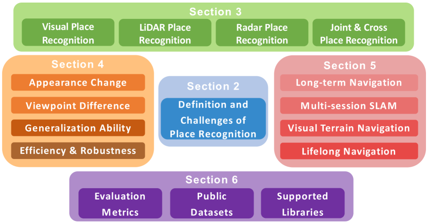
In light of the current dissociated status of PR, we aim to reduce the gap between theory and real-world application in this survey paper by analyzing the role of place recognition, describe its primary challenges, review the current solutions, and examine the potential research trends. Firstly, we re-formulate the problems and significant challenges for PR tasks in Section. II, where we argue the target for PR is to help improve the localization or data-association ability in long-term autonomy. Secondly, we analyze the current localization approaches across different sensor modalities (e.g., different visual inputs, LiDARs and RADARs) in Section III, and provide a detailed comparison of their advantages and disadvantages. Thirdly, we investigate the details of existing solutions for PR tasks in Section. IV and analyze their properties, such as condition-invariance, viewpoint-invariance, generalization ability, and lifelong application. Then, we dive deep into the status of current PR applications in real-world autonomy in Section. V and highlight the potential new trends and opportunities in large-scale and long-term navigation [5, 6], visual terrain relative navigation [7, 8], multi-session SLAM [9, 10], and lifelong autonomy [11, 12]. Though there are many place recognition datasets, one major problem is that it is either too complex (very complicated scenarios) or too simple (minimal differences) to evaluate PR performance with these datasets. To this end, we investigate the most recent public datasets that support real-world autonomy in Section. VI and also provide the corresponding python library tools at https://github.com/MetaSLAM/GPRS to help evaluate localization performance of PR methods. Finally, in Section. VII we discuss the status of current place recognition research from the perspective of real-world autonomy, which also serves as a reference for how to integrate PR with other relevant robotic and computer vision topics. In summary, the major contributions of this survey paper are as follows:
-
•
This work provides a comprehensive discussion of the current status of place recognition from the following three perspectives: Uniform Problem Formulation, Sensor Modalities, and Challenges and Solutions. We analyze both advantages and disadvantages of different solutions and modalities.
-
•
This work gives a deep dive into the Applications and Trends in real-world autonomy, which includes large-scale and long-term mobile robot localization, visual terrain relative navigation, multi-agent localization, lifelong autonomy, etc.
-
•
This work also provides a critical investigation of the Supporting Datasets and Evaluation Metrics and highlights the current limitations for reasonable evaluation of real-world localization requirements. We also provide our public datasets and open-source tools for fair comparison and analysis of future works.
II Definition of “Place” and Challenges
In nature, even for tiny creatures (insects, birds, bats, mice, etc.), the ability of place recognition plays a important role in localization and navigation in a complex world. Achieving robust localization ability also becomes one of the primary challenges for long-term real-world robotics autonomy. The fundamental questions for place recognition in real-world autonomy are 1) “what is a place?” and 2) “what are the major challenges in place recognition tasks?”.
There primarily exist two definitions for place recognition: position-based and overlap-based. In [1], Lowry et al. define the position-based place recognition as the ability to recognize previously visited areas, irrespective to the viewpoint and environmental conditional differences. The “position-based” definition is inspired by the ”place-cell” in the hippocampus, which was discovered by O’Keefe [13] and helped him win the 2014’s Nobel Prize. In contrast, Garg et al. [4] define the overlap-based PR, which estimates retrievals’ conditions using observation overlaps. By this definition, the exact location under significantly different viewpoints will be treated as additional areas. The overlap-based definition is similar to the content-based image retrieval task [14] within the computer vision community, which aims at searching an extensive database for the most similar image to a given query image. Due to this, though, overlap-based PR cannot be directly used in a SLAM framework’s loop closure detection for back-end position optimization [15].
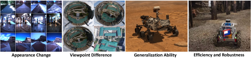
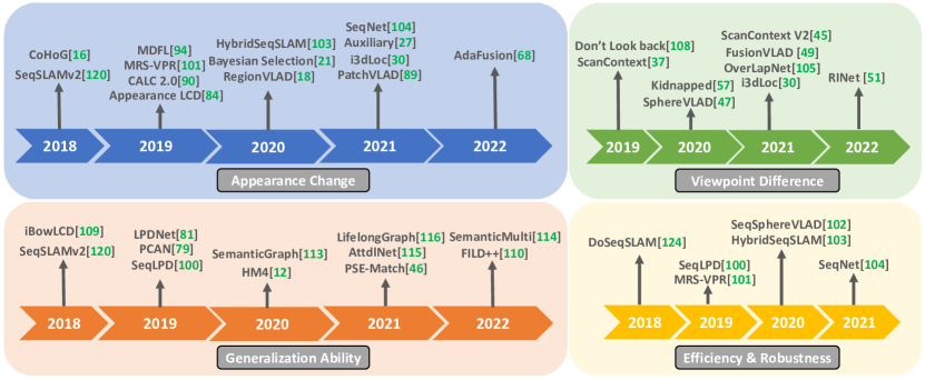
In real-world robot autonomy, appearance changes can significantly affect place recognition performance. As shown in Figure. 2, we can summarize the major challenges of place recognition into four categories: appearance change, viewpoint difference, generalization, and continual learning in real-world scenarios. Compared to short-term navigation, long-term operation may contain appearance changes under different illumination conditions or structural changes (i.e., parking lot and construction sites), which will introduce further localization failures. The viewpoint difference of the same area will decrease the place recognition accuracy in re-localization. In large-scale navigation tasks, since the complex scenarios are unlimited, the generalization ability of place recognition methods for unseen environments is one of the primary burdens. Beyond the generalization ability, the place recognition module is expected to have an online learning ability. With the developments in space exploration, more robots have been sent to other plants for long-term investigation. However, in such areas, human intervention is expensive, and the robots are expected to obtain continual learning ability for unseen areas. Using the above definitions and challenges [1, 3], we make a comparison between the two definitions in Table. I. It indicates that both types of place recognition face challenges in the current navigation pipeline.
We argue that, though overlap-based approaches are suitable for existing visual retrieval methods within the computer vision community, they are difficult to use in real-world applications. For example, how do we determine the scale of overlaps? And how do we leverage the visual retrieval for loop closure detection in a SLAM framework? It is also difficult to build the connection between overlap-based place recognition and real-world localization and navigation requirements since we cannot estimate the relative positions between different images based only on overlaps. In this case, the original position-based place recognition is more suitable for real-world robot autonomy applications. In this work, we will mainly focus on the related works that use a position-based place recognition approach using different sensor types, solutions, and directions.
III Sensor Modalities in Place Recognition
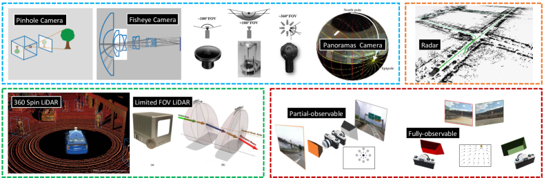
The first essential module for real-world robot localization is the appropriate sensor for the relative place recognition tasks. Since different sensors have their own unique properties, place recognition performance depends highly on the adaptability of various sensors. The critical considerations for sensor selection include 1) field of view, 2) geometric richness, and 3) robustness to environmental noise. This section will look at place recognition methods based on different sensor setups. And in Table. II, we list the relative works for different sensor modalities and analyze their properties.
| Sensor | Related Work | Place Recognition Properties |
| Partial-observable Camera | [16, 17, 18, 19, 20, 21, 22, 23, 24, 25, 26, 27, 28, 29] | These cameras are widely applied in most kinds of visual place recognition methods, but are sensitive to viewpoint differences, appearance changes, and dynamic objects. |
| Fully-observable Camera | [30, 31, 32, 33, 34, 35, 8, 36] | 360-degree cameras provide rich geometries, and can provide viewpoint (orientation)-invariant place recognition, but are sensitive to appearance changes and dynamic objects. |
| LiDAR Device | [37, 38, 39, 40, 41, 42, 43, 44, 45, 46, 47, 48, 49, 50, 51, 52, 53, 54] | LiDAR provides the most accurate 3D environment measurements, and is invariant to appearance changes, but it usually has lower resolution and textureless inputs for confined/flat areas. |
| RADAR Device | [55, 56, 57, 58, 59, 60, 61, 62] | Radar has 360-degree-view and not sensitive to both appearance and extreme weather conditions, but it has very low resolution inputs and noise cluster observations. |
| Joint Sensors | [63, 64, 65, 66, 67, 30, 68] | Joint sensors can cover the shortages of individual sensors, and the shared geometric property also make cross-modal place recognition methods possible. |
III-A Visual-based Place Recognition
Visual-based place recognition is the most investigated technique in the place recognition area. As stated in the previous visual place recognition (VPR) surveys [1, 4, 2], this area has been well studied using both traditional and learning-based approaches. This section tries to avoid repeating the previous analysis of existing VPR approaches. Instead, we highlight the new VPR approaches based on different sensor modalities. We argue that the same feature extraction approaches under different modalities may significantly differ in performance. Based on the field-of-view, the camera modalities can be categorized into two types: 1) partial-observable camera and 2) fully-observable camera.
As we can see in Figure. 3.A, the partial-observable camera mainly contains pin-hole, fish-eye, and stereo cameras. partial-observable camera systems are the most widely used device in visual place recognition tasks, and most overlap-based place recognition approaches [69] and datasets [4] are conducted under this modality. In [16], Zaffar et al. provide a non-learning method, CoHOG, which utilizes image entropy to extract regions-of-interest (ROI) and a regional-convolutional descriptor for appearance-/viewpoint-invariant visual place recognition. Oertel et al. [17] provide an augmented VPR method for the pin-hole-based visual inputs, which utilizes both raw 2D visual inputs and 3D point-cloud from structure-from-motion to enhance the place recognition robustness. Khaliq et al. [18] provide a Region-based VLAD VPR method for significant viewpoint and appearance changes. The critical contribution of this work is the lightweight CNN-based region features for fast and accurate global descriptor extraction. Ye et al. [19] propose a coarse-to-fine visual place recognition method, which extracts the global place descriptor from [70] for global matching, and parallelly with the local place descriptor for the local affine preserving matching (LAP). The proposed LAP method can provide effective and efficient feature matching for real-time geometrical verification of potential candidates. In [20], Ozdemir et al. introduce an Echo State Network (ESN) [71] enhanced method to model the spatial-temporal changes in VPR task, which can boost the VPR performance on different public datasets and shows the ability to capture temporal changes. Against the appearance changing problem, Molloy et al. [21] provide the doubled Bayesian Selection Fusion method to determine the best potential matched candidates among the potential searching database under variant environmental conditions. In [22], Peng et al. introduced semantic reinforcement attention as the feature embedding layer to enhance the recognition performance with both semantic priors and data-driven fine-tuning, which can significantly improve the image representation. To deal with the viewpoint difference in VPR, Lu et al., [23] provides a Spatio-Temporal Alignment method, which contains an adaptive dynamic time warping (DTM) mechanism to align and measure the similarity of potential matches. Waheed et al. [24] design a multi-process fusion method to fuse different VPR methods parallel for better performance. Most recently, Lee et al. [29] utilized the event camera to provide reconstructed edge-based place recognition, and the unique representation of the event camera helps extract invariant structures under dynamic luminance changing environments.
Even though the above approaches using a partial-observable camera can provide robustness against both viewpoint and appearance variants, the place recognition ability for the same area under different perspectives is still a significant challenge. As we can see in Figure. 3.C, the limited field-of-view of a partial-observable camera will cause it to observe significantly different objects from different traversal directions; meanwhile, for a fully-observable camera system, an observation with a 360-degree field-of-view will contain observations from all directions. This property enables a fully-observable camera system to have the innate advantage of viewpoint-invariant localization. There are mainly two types of omnidirectional cameras, as stated in [72]: catadioptric camera and panoramas camera. Specifically, the catadioptric camera usually contains a fisheye camera (along with reflection mirrors in [31]) with upward directions, and the panoramas camera is combined with two fisheye cameras with inverse directions. In [31], Yoon et al. provides a catadioptric camera-based VPR method, which utilizes a spectral graph matching for flattened indoor environment navigation. For aggressively maneuvering robot navigation on uneven terrain, Stone et al. [35] propose a Skyline-based localization system, which utilizes the spherical harmonics representation to provide viewpoint-invariant place recognition. Zioulis et al. [33] provide a spherical panorama-based indoor Manhattan aligned layout estimation method, which can indirectly help the indoor localization task but has the basic cuboids assumption for indoor environments. However, the field-of-view of a catadioptric configuration is limited, and the differences in the perspectives under significant pitch/roll changes will reduce the re-localization ability. In [34], the investigation by Zhang et al. shows that a 360-degree panoramic camera can provide more visual features in the visual SLAM system for odometry estimation and loop closure detection. Based on the rich feature property of a 360-degree panoramic camera, Grelsson et al.[8] propose a position estimation method for unmanned surface vessels (USVs); the most exciting point of this work is that they can handle significant viewpoint differences in pitch/roll/yaw. Their system combines a horizon line detection module to help approximate orientation estimation and a filter module to estimate the best matching localization in the Fourier domain. Liu et al. [36] provides a cross-view Geo-localization method, which contains a Siamese network to encode both 360 panorama images and the Google satellite images for geo-relative localization. However, in the above applications, the localization robustness against viewpoint differences and the distortion problem caused by pitch/roll changes significantly affect the extracted visual features. To deal with this problem, Yin et al. [30] provide an orientation-invariant place feature extraction method, which adds the orientation-equivalent property of spherical harmonics [73] to viewpoint-invariant place descriptors.
III-B LiDAR-based Place Recognition
In contrast to vision sensors, LiDAR-based devices can capture the 3D geometric structure of the surrounding environments via laser beams, which makes LiDAR-based place recognition (LPR) invariant to conditional differences, such as illumination, weather, and seasons. As shown in the Figure. 3.C, there are two kind of LiDAR devices that are widely available, Spin LiDAR (Velodyne VLP, 32E, 64E, etc [74]) and Non-repetitive LiDAR (Livox LiDAR, Mid-40, AVIA, etc [75]). The Spin LiDAR devices usually have measurement range and 360-degree field-of-view but are also expensive and have low-resolution sensor inputs; in contrast, the Non-repetitive LiDAR devices are relatively cheap and can provide high-resolution inputs, but their field of view is fairly limited. This subsection will introduce the related works in LPR.
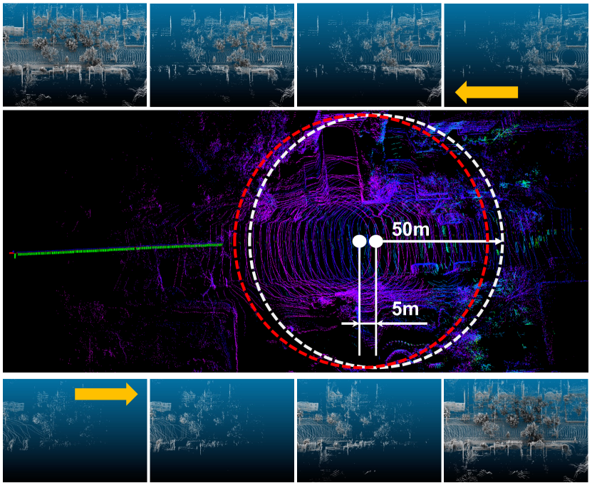
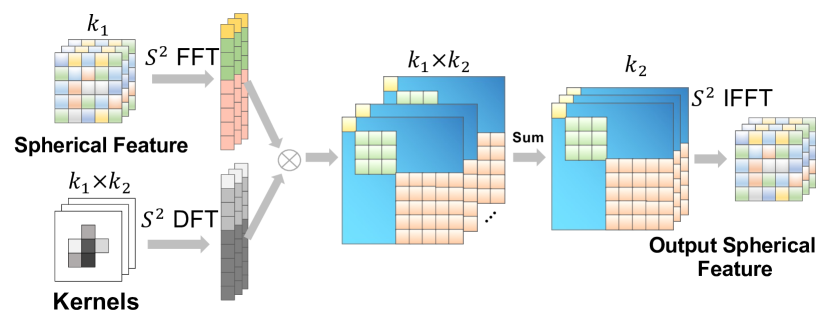
Based on the development of Deep 3D feature extraction, Uy et al. [76] provide 3D LPR method by combining the PointNetVLAD [77] feature extraction approach and NetVLAD [78] feature cluster method, which transform the successful visual place recognition technique into LiDAR domain. However, different from visual inputs, the low-resolution raw LiDAR inputs make it hard to encode local features into the distinguishable global descriptor. Guo et al. [38] design an enhanced place descriptor by combining both LiDAR point cloud and its calibrated intensity returns, showing significant performance improvements over pure geometric-based methods. Zhang et al. [79] propose an attention [80] enhanced place feature extractor, which can predict the significance of local points based on their context. To enhance the connection of local 3D structures in the large-scale point cloud, Liu et al. [81] introduces a graph-based neighborhood aggregation module to reveal the spatial distribution within the global descriptor. Zhu et al. [39] provide a coarse-to-fine strategy to perform semantic-level rough alignment and accurate pose refinements with 3D geometric registration. To deal with the sparsity LiDAR scan in long-term place recognition, Siva et al. [40] developed a voxel-based representation learning method. Yin et al. [46] utilize a parallel semantic embedding module to encode different kinds of objects (ground, building, small structures, etc.) and a divergency learning module to learn more robust 3D place descriptors under long-term variants. To deal with the sparsity of a single scan and provide a consistent place descriptor, Yin et al. [49] accumulate LiDAR scans into dense sub-maps for LPR feature extraction. As shown in Figure. 4, the generated dense sup-map can improve the LiDAR map similarity under inverse directions, and similar approaches have also been applied in [76, 81, 43]. Vidanapathirana et al. [48] utilize a second-order pooling to aggregate the topological and temporal semantic information to the place descriptor, which shows higher robustness to viewpoint changes and occlusions.
However, the PointNet [77] structure is not suitable to capture local geometric structures, especially under orientation differences, which will cause a performance drop under viewpoint differences, as mentioned in [81, 48]. In [37], Kim et al. provides a rotation-invariant 3D place descriptor through the structural appearance of polar context projection; however, this method is robust to orientation difference but very sensitive to local translation difference due to polar representation. Li et al. [51] propose a rotation invariant place descriptor via a series rotation-invariant network structures (convolution, attention, down-sampling). In [47], Yin et al. provide a spherical harmonica-based 3D map encoding method, the rotation-equivalent property of spherical harmonica [73] enhance the extracted place descriptors are invariant to local viewpoint differences. As an extension of [37], Kim et al. [45] provides a structural appearance-based LPR method, the new method can extract both translation- and rotation- invariant LiDAR place descriptor simultaneously. In [49], Yin et al. provides a fusion-based multiview place feature encoding method, which can combine the translation-invariant property of the top-down view and the rotation-invariant property of the spherical view and give an even robust 3D descriptor. Komorowski et al. [43] introduce a voxelization representation for the 3D LPR task and utilize sparse 3D convolution for place descriptor extraction, which has shown significant improvements to PointNet-based methods. As an extension of [43], Zywanowski et al. [44] utilize spherical coordinates of 3D points and LiDAR intensity measurements to further improve the recognition robustness with even a single sparse LiDAR scan. Vidanapathirana et al. [52] also utilize the sparse convolution in LPR descriptor extraction and provides a local consistency loss to guide the network to learn consistent local features across revisits, which also significantly improves the re-localization accuracy compared to other sparse convolution-/PointNet- based LPR approaches. For the Non-repetitive LiDAR device, Lin et al. [53] develop a fast loop detection approach where they calculate the cross-correlation of 2D histograms to estimate keyframes’ similarities. Wang et al. [54] utilize the ScanContext [37] in the Non-repetitive scans for place recognition.
III-C Radar-based Place Recognition
Different from camera and LiDAR sensors, which are operated under near-visible electromagnetic spectra (higher frequency, from THz to PHz), Frequency-Modulated Continuous Wave (FMCW) scanning Radar devices are usually performed under much lower frequency (GHz) [62]. The property of the Radar device makes it not sensitive to illumination differences, appearance changes, and extreme weather conditions (i.e., fog, mist, rain, snow, etc.). And currently, available Radar devices can also provide 360-degree field-of-view with up to hundreds of measurement abilities. The above properties make Radar-based place recognition (RPR) suitable for challenging outdoor localization under extreme weather conditions [60]. In [62], Hong et al. provide a complete radar SLAM system, which includes the motion estimation for reliable feature tracking, a motion distortion module to refine the pose estimation, and an M2DP [82] based place recognition module to provide efficient loop closure detection for large-scale SLAM tasks.
However, Radar devices have a typical limitation compared to a camera and LiDAR devices, low spatial resolution and noise cluster observations, making Radar-based place recognition still very challenging. In [55], Gadd et al. provides a sequence matching-based RPR method against the noise clusters within single scans, which can achieve a performance boost on km urban environments. However, in the real-world RPR task, the relative datasets are limited compared to camera-/LiDAR- based ones. Tang et al. [56] provide a self-supervised fusion method for RPR task, which is cheap to train without accurate ground truth. Specifically, they utilize public satellite images to simulate the Radar projections for metric localization learning. In [59], Cai et al. develop the dynamic points removal module to reduce the vibrant noise and the deep spatial-temporal feature embedding module to improve the extracted Radar points quality. Like the 360-degree LiDAR device, rotation differences may also encounter viewpoint differences in the RPR large-scale localization. Suaftescu et al. [57] provide a rotation-invariant radar-based place recognition method, which utilizes the cylindrical convolutions, anti-aliasing blurring, and azimuth-wise max-pooling to improve the recognition accuracy for polar radar scans in large-scale outdoor localization task. Gadd et al. [58] provide a data augmentation approach in the place descriptor training procedure, which can further improve the RPR performance.
III-D Joint and Cross Place Recognition
As we summarized in Table. II: vision sensors can provide rich texture and semantic information but are sensitive to illuminations and environmental condition differences; LiDAR devices are robust to the above appearance changes but have low-resolution data outputs and are sensitive to occlusions; Radar devices give even longer detections than LiDAR and are robust to extreme weather conditions but contain lots of measurement noise. Each sensor modality has unique adaptive properties (i.e., long-range in visual sensor, illumination-invariant in LiDAR sensor, and dust-invariant in Radar sensor), distinguishes abilities under different environmental conditions, and shares commonalities. Based on the properties mentioned above, there mainly exits two kinds of multi-modality place recognition approaches: 1) for the purpose of robust general place recognition, the combination of multi sensor modalities provides enhanced Joint place recognition methods [64, 65, 66]. 2) based on the commonality of different modalities on the same geometric structures, the Cross place recognition methods provide efficient and low-cost re-localization over existing maps [67, 63, 61, 30].
For the Joint place recognition, Shan et al. [64] developed an ORB descriptor based on both visual inputs and LiDAR intensity readings, which is invariant to rotation differences due to the panoramic perspective and RANSAC-based outlier rejecting. In [65], to improve the navigation robustness under cross-scene (ground, water, surface) environments, Yu et al. provide a multi-modal deep feature fusion method for both LiDAR and image inputs. Specifically, they also utilize the semantic feature to enhance the point cloud feature. The final place descriptor is aggregated from a fusion layer, which shows higher robustness than the original LiDAR and image features. Similar to [64], Bernreiter et al. [66] applies the spherical convolution neural network for the joint LiDAR and camera inputs to extract global place descriptor, which shows better recognition accuracy and robustness to viewpoint differences. However, the place recognition performance of different sensor modalities may also depend on the relative environmental conditions, i.e., the visual sensor in the dark environment and the LiDAR sensor under flattened areas. To deal with this problem, Lai et al. [68] provides an end-to-end adaptive fusion approach, which can be based on the individual sensor performance under different conditions and adjust their feature weightings in the global place descriptor fusion.
For the Cross place recognition, Cattaneo et al. [67] provides a cross-domain visual localization within existing LiDAR maps, which trains a 2D VPR network and a 3D LPR network simultaneously and provides robust cross-domain localization under changing weather and lighting conditions. In [63], Di et al. utilize the stable intensity measurements from the LiDAR device, and provide a deep evaluation of the VPR method against existing LiDAR intensity data; the relative results on different public datasets suggest that visual-to-intensity-based place recognition can deliver reliable performance in large-scale visual navigation. Yin et al. [30] provide a condition- and viewpoint- invariant place recognition method based on a conditional domain transfer module and an orientation equivalent extraction module. In [61], Yin et al. provide Radar localization method against the LiDAR maps, where both Radar and LiDAR maps are fed into the standard embedding networks to learn cross-matching features.
IV Key Strategies in Place Recognition
As we stated in Section. II, the primary challenges for place recognition can be categorized into four types: 1) Appearance change, 2) Viewpoint difference, 3) Generalization ability, and 4) Lifelong performance. We will investigate them separately.
IV-A Appearance Change
As one of the main challenges in place recognition, appearance changing can introduce recognition failures for the same areas and perceptual aliasing where different places generate similar visual observations. In long-term place recognition, there are two types of appearance changes:
-
•
Conditional changes, contains the appearance changes caused by environmental conditions, such as illuminations, weather, and seasons. This type of change will mainly affect the visual observations over time.
-
•
Structural changes, contains the dynamic objects, geometric transformations, and landform changes over short-term or long-term navigation. Both vision and LiDAR sensors can be affected, but the Radar device can survive because of its low-frequency observation property [62].
As pointed in [2], there mainly exist two kinds of approaches to deal with the above appearance changes, 1) place modeling, which utilizes the conditional-invariant features for stable place recognition, and 2) belief generation, which estimates the place similarity based on the sequence of observations.
With the rapid development in computer vision [83, 84, 16] deep learning [85, 86], and adversarial learning [87, 88], the place modeling based PR methods [18, 27, 89, 30] have gained lots of attention. In [84], Tsintotas et al. provides a training procedure to capture repeated scale-restrictive features and a voting mechanism to detect the potential loop closures within the distributed database. Merrill et al. [90] combines different visual modes information to extract rich place recognition features for robust re-localization. Inspired by the success of region-based visual object detection, Khaliq et al. [18] provides a Region-based VLAD feature aggregation module, which utilizes the pretrained AlexNet [91] for stable local region feature extraction. Hausler et al. [89] provides a multi-scale patch feature fusion mechanism to combine both local and global descriptions to boost the place recognition accuracy. Hausler’s method can aggregate local features over the feature-space grid, which is robust to environmental condition differences. However, the performance of the above methods is highly dependent on the pretrained model on existing datasets, and the adaptation ability is limited. Zaffar et al. [16] provide a training-free VPR approach, which combines the traditional HOG [92] descriptor and the regional feature extraction and convolution matching mechanism to achieve competitive recognition performance without training. Piasco et al. [27] introduce the auxiliary modality for the VPR task, which can infer depth prediction from the visual inputs and combine with the visual CNN features to extract robust global place descriptor. However, this work assumes there are paired image-depth data. Thus, the localization performance and generalization ability are highly reliant on the dataset and the depth of image quality. Based on the feature extraction ability of CapsuleNet [93], Yin et al. [94] provide a multi-domain feature learning method, which can capture different attribute descriptions from the diverse observations and separate the condition-invariant features for recognition. As an extension of [94], Yin et al. [30] further provides a cross-domain transfer module, different from the previously fixed domain-transfer method [88], this method introduces a conditional adversarial feature learning network to extract conditional-invariant visual features under multiple environmental conditions. However, the complex variant environmental conditions make the place recognition still challenging even under the assistance of place modeling. Molloy et al. [21] combine the NetVLAD-based place feature extraction with a Bayesian selective fusion approach, which can find target matches under relative domains. But this approach requires complete reference images under all domains.
For belief generation based PR methods, SeqSLAM [95] introduced by Milford et al. provide the well-known sequence matching method. In contrast to the traditional single frame-based place recognition methods, such as FAB-MAP [96] and Bag-of-Words [97], SeqSLAM finds the best matches by aligning a pair of reference and query sequence and can accurately capture the continuous geometric similarities under Conditional changes even with most traditional visual features [92, 83]. Since , there exist a wide body of literature [35, 98, 99, 100, 101, 102, 103, 104] benefiting from the SeqSLAM mechanism to provide more robust place recognition. In [35], to stable place recognition ability on a rough terrain under changing conditions, Stone et al. combines the SeqSLAM matching mechanism with the segments of skylines, which shows improved condition-invariant property during bumpy trails. To improve the searching efficiency of SeqSLAM, Siam et al. [98] provides a fast version of SeqSLAM, which utilize the approximate nearest neighbor (ANN) to greedily search the sequence instead of traditional burst-force searching and can significantly reduce the searching time without degrading the localization accuracy. However, this method initially needs good initial estimation, thus not suitable for large-scale global re-localization. In [101, 102], Yin introduces a multi-resolution sampling-based global place recognition mechanism for VPR [101] and LPR [102]. Yin’s method combines the coarse-to-fine re-sampling with particle-filter to achieve hierarchically global re-localization; this approach can balance the matching accuracy and efficiency and help provide near real-time global localization ability in long-term navigation. Instead of using burst-force searching over the difference matrix in SeqSLAM, Bampis et al. [99] provides a sequence bag-of-words with a novel temporal consistency filter, which can benefit from sequence matching manner but also maintain the real-time performance on a tablet device. In [103], Chancan et al. combines a compact and sparse neural network, FlyNet, and a continuous attractor neural network (CANN) to capture the sequence of observations, which can provide a better performance than SeqSLAM. Similarly, to [103], Garg et al. [104] also provides sequence global descriptor by using a temporal convolutional network, which can construct a hybrid place recognition system by combining both global matching and the local sequence matching.
IV-B Viewpoint Difference
As stated in Section. IV-A viewpoint differences can affect the recognition ability for all kinds of sensor modalities as one of the significant challenges in place recognition. In long-term navigation, the observation in the same place may have variant patterns under different perspectives.
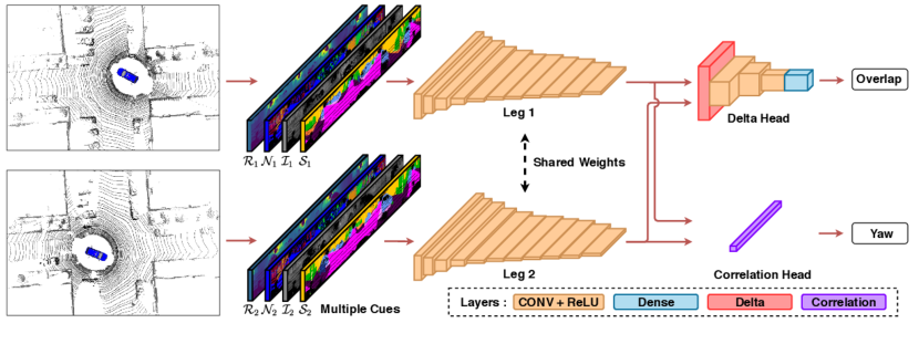
To improve the robustness of viewpoint difference, traditional place recognition methods, such as Bag-of-words [97], Fisher Vector [106], and Vector of Locally Aggregated Descriptors(VLAD) [107], have been investigated for more than ten years. However, the above methods can not deal with arbitrary viewpoint differences or inverse directions. The distribution changes caused by viewpoints will be treated as different places in Position-based place recognition. Garg et al. [108] provide semantics-aware neural networks to recognize the same place under inverse directions. However, this method can only deal with inverse-direction recognition, while arbitrary real-world differences are more common in indoor/outdoor navigation. As analyzed in Section. III, the panorama camera, LiDAR, and Radar can provide fully-observable sensor inputs, which are highly suitable for viewpoint invariant place recognition. As we mentioned in Section. III-B, Kim et al. [37, 45] provide a rotation-invariant descriptor through polar context projection; and Li et al. [51] also propose a rotation-invariant place descriptor via the combination of rotation-invariant network structures. In [102, 30], Yin et al. maps the LiDAR or 360-degree visual inputs to the spherical projections, and utilize the orientation-equivalent property of spherical harmonics to provide orientation-invariant place recognition methods as shown in Figure. 6. Chen et al. [105] develop a deep neural network to estimate the overlap similarly based on the overlap estimation from two LiDAR scans and parallel estimate the relative yaw angles via the delta-operation as depicted in Figure. 7. However, the overlap-based methods need to calculate each potential data pair; this procedure can make training and evaluation procedures time-consuming compared to the global descriptor-based spherical harmonics methods. Based on the dense local maps, Yin et al. [49] provide a multi-perspective fusion-based LPR, which benefits from the translation-invariant property of top-down inputs and the orientation-invariant property from a spherical view. In [57], Suaftescu et al. provides an orientation-invariant RPR method, which utilizes cylindrical convolutions along with anti-aliasing blurring, and azimuth-wise max-pooling to improve the localization accuracy for the noise Radar inputs.
IV-C Generalization Ability
Generalization ability indicates the place recognition of unseen environments. The real-world scenarios are infinite, given the same place can be presented under different environmental conditions, as stated in Section. IV-A, there is no boundary for the above combination of place datasets, which is impossible to collect at once.
In traditional methods, FAB-MAP [96] build a Bag-of-visual-words (BoW) architecture to achieve large-scale visual re-localization. iBoW-LCD [109] uses an incremental BoW scheme based on binary descriptors to retrieve matched images more efficiently. An et al. introduces FILD++ [110], an incremental loop closure detection approach via constructing a hierarchical small‐world graph. However, the generalization ability of the above non-learning-based methods is highly restricted, and robust performance usually comes with specific parameter fine-tuning. With the development of deep learning-based feature extraction [85, 111] and attention mechanism [80], learning-based place feature extraction methods have gained more attention in recent years. Khaliq et al. [18] combine the region of CNN features and a differentiable NetVLAD [78] layer to enable the generalization ability of the VPR task. Based on the attention mechanism, Zhang et al. [79] proposes a Point Contextual Attention Network (PCAN) to enforce the differential networks by paying more attention to the task-relevant features, which can further boost the robustness of LPR methods. In [68], Lai combines the advantages of different sensor modalities and proposes the attention-enhanced multi-modal fusion-based PR method, which can balance the feature weights based on the environmental conditions to boost the localization performance. In the most recent works, Zhao et al. [112] extend the original SphereVLAD [47] with an attention mechanism to increase the signal-noise ratio of extracted place features, which can improve the global feature distinguishable ability in large-scale place recognition.
On the other hand, the semantic segments in the 3D environments are usually more robust to the environmental changes. Based on this property, Kong et al. [113] provide semantic graph-based place recognition methods and utilize a graph-matching to improve localization performance under occlusion and viewpoint differences. Similarly, Yin et al. [46] propose a parallel semantic feature encoding module, which extracts the different types of semantics (tree, building, etc.) and utilizes a divergence place learning network to improve the robustness of place recognition. Most recently, Paolicelli et al. [114] combined the visual appearance and semantic context through a multi-scale attention module for robust feature embedding.
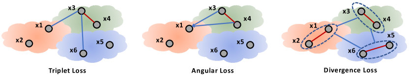
In recent years, new kinds of loss metrics have also played an essential role in boosting place recognition performance. Triplet loss is a standard metric in the existing place recognition methods [78, 76], which constructs the query-positive-negative pairs (based on the Euclidean distance). It stretches from the query to the positive references are minimized, and the negative inputs are maximized, as shown in Figure. 8. Based on the triplet loss, Yin et al. [47] provides a rotation triplet loss during training to improve the orientation-invariant performance. The angular loss is another typical selection for the learning place descriptor except for triplet loss. Barros et al. [115] use the cosine similarity to construct the angular loss, and angular (cosine) distance is a similarity-transform-invariant metric, which is more robust than the euclidean distance in triplet loss. However, the above loss metrics mainly consider the distance between individual cluster members with inner or external members; they do not necessarily look at the various aspects of the place recognition task explicitly. As shown in Figure. 8, divergence loss can explore this perspective through different ensemble modules. And based on the above property, Yin et al. [46] developed a divergence loss metric, which can enforce the place feature learning procedure care different semantic structures (i.e., trees, buildings, roads, etc.) separately. Except for the above loss metrics, Li et al. [51] treats place recognition as a classification problem, Chen et al. [105] utilizes a scaled sigmoid loss to estimate the overlaps between observations and achieves competitive performances.
Finally, even considering all the above approaches, developing a robust place recognition method can handle the unbounded combinations of environmental conditions and unlimited scenarios in the real-world place recognition task. One potential solution is lifelong learning based on place recognition. Lifelong learning, also known as continual learning, aims at providing incrementally updated knowledge in ever-changing environments. In [12], Doan et al. provides a Hidden Markov Model approach with a two-tiered memory management system, which can maintain the lifelong learning property by keeping necessary candidate images within the memory zones. Kurz et al. [116] provide a graph pruning-based method for lifelong LiDAR SLAM, which can remove vertices and edges to keep the graph size reasonable when repetitive visit previous areas.
IV-D Efficiency & Robustness
In real-world applications, efficiency and robustness are essential properties for long-term robotic localization. The most straightforward place match technique uses a single-frame-based re-localization approach [117, 118], which can provide efficient localization for static and short-term navigation tasks. However, real-world applications are full of dynamic changes and long-term appearance differences, and repetitive appearance patterns. The above factors restrict the single frame-based place recognition approaches. Instead of a single frame, sequences matching [95] can improve the tolerance to local scene changes and reduce false positives with self-similarities. SeqSLAM [95] and its related works [119, 120], use a brute force method to perform sequence matching. And based on the success of SeqSLAM, new learning-based methods [100, 101, 102, 103] have further boosted the place recognition performance in long-term localization tasks. It improves the matching accuracy but is time-consuming in practice and cannot be directly used in real-time. Thus, [121, 122, 123] proposed different methods to increase the efficiency of SeqSLAM by using particle filter, approximate world’s nearest neighbor, and the Hidden Markov Model. Methods efficiency may decrease when the number of reference sequences is enormous. [124] and [125] improves SeqSLAM by using dynamic query sequences and binary descriptors. These methods’ performances highly depend on the condition of the environment, which is not robust enough to perform in changing and challenging environments.
V Application & Trends
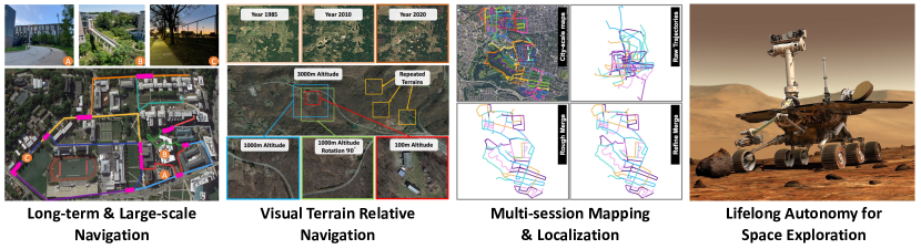
For future applications, there exist lots of potential directions in place for recognition. In this section, we pick up four primary directions: 1) long-term and large-scale navigation for UGV robots, 2) visual terrain relative navigation in UAV robots, 3) multi-session SLAM, and 4) lifelong autonomy. We analyze each direction’s current status, potential outcomes, and future research trends.
V-A Long-term & Large-scale Navigation
Currently, the most in demand application for place recognition is the long-term and large-scale navigation, such as autonomous driving [5], last mile delivery [6], and indoor service robots [126], etc. In the above applications, robots are expected to navigate within our daily changing indoor/outdoor environments. Except for the major challenges analyzed in Section. II, place recognition also needs to deal with the sensitive identity information [127], the high-frequent dynamic objects, and low-frequent updated geometries.
In [128], Torii et al. analyze the place recognition ability under changing environmental conditions and provides a condition-invariant large-scale VPR method and extensive comparable datasets. For the street localization task, Liu et al. [36] provide a cross-view matching for the large-scale geo-localization and encoding of both orientation and geometric information to boost the recall rates in spatial localization, which helps the city-scale robust localization. With the developments of deep-feature extraction [129], Sarlin et al. [70] provides a large-scale hierarchical localization approach, which develops a monolithic CNN structure that encodes both local geometric features and global descriptor to achieve the coarse-to-fine 6-DoF localization within large-scale environments. In [30], Yin et al. provide the cross-modality visual localization approach within large-scale campus areas. Based on pre-built 3D LiDAR maps, they provide cross-domain transfer networks to extract condition-invariant features from optical inputs and learn the geometric similarity to the relative LiDAR projections in long-term navigation. In [42], Rozenberszki et al. integrates the LiDAR odometry and LiDAR-based place recognition method and provides a pure LiDAR-based mapping and localization system, which significantly improves the real-time localization accuracy and mapping precision in the large-scale navigation. And in most recent works [43, 48, 52], different kinds of novel 3D place descriptors have also been investigated to boost the long-term localization performance in large-scale navigation tasks. To improve the localization robustness under extreme weather conditions, Hong et al. [62] propose the entire Radar SLAM system for city-scale environments, and the experiment results also show that the place recognition performance can also support all-weather conditions.
As analyzed above, long-term and large-scale navigation is currently the central research direction for place recognition, which can directly combine with most real-world robotic applications. With the development of new deep feature extraction methods and different configurations of sensor modalities, this area can provide new breaking points.
V-B Visual Terrain Relative Navigation
Visual terrain-relative navigation (VTRN) is the visual localization method that can provide UAVs localization results via image registration against the target images. Satellite imagery is relatively easy to obtain (on earth or other planets), which can be applied as a ground-truth image for long-term VTRN tasks. With the lightweight camera device and widely accessible satellite images, the VTRN approach can provide robust long-term localization in GPS-denied environments under variant conditions. Due to the condition changes (Section. IV-A), viewpoint differences (Section. IV-B), and limited generalization ability (Section. IV-C), large-scale visual terrain relative navigation is still a challenging task.
To deal with changes in environmental conditions, Mishkin et al. [130] modified BoW approach [131] with multiple descriptors and adaptive thresholds to better cope with large-scale changes in environments. Bhavit et al. [132] introduce a visual terrain navigation method where reference images are rendered from Google Earth (GE) satellite images. However, because such overhead images from GE are captured several years before test time, visual differences between reference/testing streams reduce localization accuracy. To deal with this issue, Mollie et al. [133] utilized an Auto-encoder network to transfer raw images into overhead images, ignoring local dynamic differences or environmental condition changes. However, this method cannot handle illumination, weather, and seasonal changes, reducing the generalization ability for unseen conditions. In their recent work [7], Anthony et al. provide a seasonally invariant profound transform neural network to convert seasonal images into a stable and consistent domain for visual terrain navigation. This method targets high-altitude flying modes, where there exist rich unchanging geometric features that persist even in different seasons. However, in lower altitudes, this method’s transferability will be negatively affected by occlusions of 3D objects and highly variable lighting conditions from other times of the day. Another solution to deal with disturbances from environmental conditions is to match horizontal lines extracted from a query image against those rendered from digital elevation models (DEM) [134]. In [135], Baatz et al. demonstrate terrain localization by leveraging this method. Similarly, Bertil et al. [8] introduced an accurate camera localization for unmanned surface vessels (USVs) by aligning horizontal lines with coastal structures. A significant drawback of horizontal line-based approaches is dependence on rich 3D geometric structures, such as mountainous or coastal areas, and relative place recognition performance will reduce in homogeneous and plain environments. A significant drawback of horizontal line-based approaches is dependence on rich 3D geometric structures, such as mountainous or coastal areas.
In general, VTRN localization is also a new research area within place recognition, which benefits from recent new domain transfer and deep feature extraction techniques. With the development of drone delivery and Mars exploration, the development of VTRN can be further extended.
V-C Multi-session SLAM
With the development of the autonomous system, the multi-agent system has been considered to explore extensive and complex areas. It can significantly improve the operation ability of the single agent system. And most recently, in the rover-copter system on Mars, the copter can provide better perception prediction ability in long-term rover negotiation [136]. In general, collaborative multi-agent localization can benefit efficient map sharing for efficient exploration and improving perception ability for better decision making. However, as pointed in Section. IV-A and Section. IV-B, the appearance-/viewpoint- differences from different agents will cause data association failures for multi-agent cooperation.
Van et al. [9] provide a collaborated SLAM system with compressed visual features, and enable the collaborative mapping of multi-agents on the KITTI dataset. In [136], Sasaki et al. provides a rover-copter-orbiter cooperative system, which utilizes the satellite images to achieve cooperated localization between the three agents; and based on the rich texture from the copter, the orbiter can generate a better path for the rover robot. In [137], Ebadi et al. provide a geometric-based multi-agent SLAM system for unstable underground environments, which develops a robust filtering mechanism via the consistent incremental measurement (ICM) [138] to reject noise data association. However, the performance of the point-based approach is highly dependent on the robustness of 3D geometric features. In recent work, Kimera [10], Rosinol et al. provide a deformation graph model to merge 3D meshes between different agents, which can ensure 3D mesh consistency when used in multi-agent distributed mapping [139]. In [140], Labb ’e et al. provide a multi-session mapping using visual appearance-based LCD methods, through which a single robot can map separate areas in different sessions without giving relative initial transformations between different trajectories. The above methods show the potential directions in multi-agent localization. Still, we also need to note that the success of large-scale map merging is highly reliant on place recognition ability. However, most of the above methods focus on single-agent inner data association. Still, few show promising results for large-scale multi-agent map merging tasks, where significant perspective and appearance differences between observations may exist. In most recent work, Yin et al. [141] provide a large-scale data-association and map merging framework, which can extract viewpoint-invariant place descriptor and reject the unreliable loop-closures in the global map merging.
Multi-agent localization can be applied as the basis to support the cooperation between single-/multi- type robots, which can provide new cross-field research points in the future.
V-D Lifelong Autonomy
Recent years witnessed remarkable developments in NASA’s new robotics rover (Perseverance) operation on Mars [142] and CNSA’s teleoperated rover (Yutu-2) on the Moon [143]. But due to the costly remote operation and impractical communication, long-term and real-world autonomy ability have become necessary in future robotic systems, which will incrementally encounter unknown environments in the large-scale exploration task. As stated in Section. II, robust place recognition needs to handle all the conditional and viewpoint challenges. The relative generalization ability is still limited when encountering new scenarios, as analyzed in Section. IV-C. As the most fundamental module in Space/underground exploration, the localization system can directly influence the planning and decision-making strategy. In this case, life-long place recognition has been put into an essential role in achieving long-term autonomy. Precisely, the robots may re-visited the same place under different environmental conditions and dynamic changes. In the above case, merging the maps and detecting environmental changes can also affect lifelong autonomy performance. On the other hand, the robotic systems need to incrementally build up the localization knowledge from a sequentially updated data stream [144, 145] without access to the complete datasets during the supervised/semi-supervised training manner.
Tipaldi et al. [146] provide a traditional probability-based lifelong localization approach, which combines a particle filter with a hidden Markov model to evaluate the dynamic changes of local maps. In [147], Zhao et al. introduce a lifelong LiDAR SLAM framework for the long-term indoor navigation task, which mainly utilizes a multiple-session map to build and refine maps and parallelly maintain the memory usage via a Chow-Liu spanning tree-based optimization approach. In real-world navigation, most SLAM methods suffer more from lower dynamic objects (i.e., parking cars) than high dynamics (i.e., moving cars). Inspired by this observation, Zhu et al. [148] provides a semantic mapping enhanced lifelong localization framework, which can also combine existing object detection methods to update existing maps. However, the above methods are restricted to local scale tasks. To tackle the large-scale applications, Yin’s work [141] provides a long-term map merging system for city-scale environments, which utilizes an adaptive loop closure selection filter that can detect stable matches for large-scale and long-term associations.
Lifelong place feature learning is primarily evaluated against catastrophic forgetting, while most exciting place recognition methods mainly focus on short-term localization or fixed pattern localization [69], catastrophic forgetting happens inevitably. In [11], Mactavish et al. provides a vision-in-the-loop navigation system, which contains a visual teach-and-repeat approach to enable long-term online visual place feature learning and a multi-experience localization mechanism to help observations locate the relevant experience references. As an extension of [11], Dall et al. [149] provides a conditional teach-and-repeat visual navigation approach, which utilizes the odometry pattern as outside signals to guide the visual place feature learning. However, in real-world localization tasks, the data stream is infinite, combining different areas under variant environmental conditions. To tackle the scalability issue, Doan et al. [12] provide a Hidden Markov Model approach with a two-tiered memory management system, which maintains an active memory and passive storage and transfers necessary candidate images between the above two memory zones to keep the lifelong property. Doan’s approach provides a new perspective on handling long-term navigation scalability issues and allows constant time/space inferencing.
Compared to other research directions, lifelong place recognition is still very young, and we can notice that there still exist many potential points in map factor and memory management for the requirements of long-term navigation tasks.
VI Datasets & Evaluation
As mentioned in Section. III, the performance of different kinds of place recognition methods depends on the environmental conditions and sensor configurations. The appropriate datasets and evaluation metrics are highly relevant to provide adequate evaluation for place recognition methods. In this section, we will investigate the current publicly available datasets in place recognition, the star-diagram evaluation metrics given fair consideration on different place recognition properties, and support libraries for place recognition.
| Method | Scenarios | Geographical Coverage | Sensor Inputs | Appearance Diversity | Viewpoint Diversity | Dynamic Diversity |
| Nordland [150] | Train ride | km | Pin-hole Camera | Four seasons | ✗ | ✗ |
| KITTI [151] | Urban Street | km | LiDAR, Pin-hole camera | Day-time | ✗ | ✔ |
| NCLT [152] | Campus | km | LiDAR, Panoramas Camera | Season | ✔ | ✗ |
| Oxford RobotCar [153] | Urban + Suburban | km | LiDAR, Pin-hole | All kinds | ✗ | ✔ |
| Mapillary [154] | Urban + Suburban | km | Pinhole Camera | All kinds | ✔ | ✔ |
| KITTI360 [155] | Urban Street | km | LiDAR, Pin-hole/Panoramas Cameras | Day-time | ✗ | ✔ |
| IndoorVPR [156] | Indoor | LiDAR, Pin-hole/Panoramas Cameras | Day-time | ✔ | ✗ | |
| ALTO [157](States) | Urban+Rural+Nature | km | Top-down Pin-hole Camera | Day-time | ✔ | ✗ |
| ALITA [158](City) | Urban + Terrain | km | LiDAR | Day time | ✔ | ✔ |
| ALITA [158](Campus) | Campus | km | LiDAR, Panoramas Camera | Day/Night | ✔ | ✔ |
VI-A Public Datasets
Robust and accurate place recognition required extensive training and evaluation of datasets. Recall the analysis in Section. III, the suitable datasets for different place recognition approaches also vary based on the sensor modalities. Though general investigations already exist on place recognition datasets [150, 159, 160, 154, 156], we notice that the connections from existing datasets to the sensor modalities and major challenges are still missing. In Table. III, we list all the relative publish available datasets with their properties.
For the most common visual place recognition, the relative datasets are mainly focus on environmental conditions(i.e., illuminations [128], weathers [94], seasons [150], and dynamic objects [161]) and viewpoint differences [4]. The well-known Nordland [150] dataset provides a cross-season visual dataset with a journey with a camera mounted on the train; this dataset has been widely applied to evaluate the condition-invariant [94] or large-scale [95] visual place recognition. However, these datasets can not provide viewpoint-invariant analysis due to the fixed perspective, which makes the evaluation constrained under seasonal changes. In [162], Smith et al. combine the visual inputs and Laser data for campus area data collection, but both the space- and time- scales are restricted for long-term and large-scale evaluation. Warburg et al. [154] provide the most long-term and large-scale visual place recognition datasets collected in years, under both urban and suburban areas, with diverse condition differences, which is highly suitable for lifelong outdoor visual place recognition. For LiDAR place recognition, except for the most well-known KITTI [163] datasets, the most recent autonomous driving datasets [164, 165] also give large datasets under all kinds of open-street environments. Ramezani et al. [166] provide campus-scale LiDAR and stereo-inertial datasets, which can be applied for VPR, LPR, and cross-modality place recognition. For Radar-based place recognition, Sheeny et al. [167] provide extensive Radar datasets, which contains a variety of weather and driving scenarios to help investigate the performance of Radar device against extreme environmental conditions. In [41], Kim et al. provide a multimodal dataset with parallel Radar and LiDAR sensor inputs; specifically, they also offer both raw-level and image-format radar data to analyze the place recognition performance of different configurations.
Except for the above commonplace recognition tasks, other essential scenarios exist in place recognition. The identity information is also one necessary factor in place recognition; Sheng et al. [127] provides a new VPR dataset to analyze effects when removing all identity information within visual inputs. For long-term visual terrain relative navigation (VTRN), Ivan et al. [157] provides a large-scale VPR dataset for UAV long-term navigation. Specifically, they provide raw top-down visual inputs from the helicopter and the corresponding satellite images to analyze how simulation data can benefit real-world navigation. For the purpose of multi-agent map merging, Yin et al. [158] provide a large-scale LiDAR datasets, which contains trajectories and overlaps in city-scale environments, and trajectories and overlaps in campus-scale environments. Most recently, Liu et al. [156] provided intensive indoor localization datasets with RGB panorama images, LiDAR scans, and query images from smartphones for cross-modal place recognition. Shi et al. [168] provide long-term indoor visual datasets with daily environmental changing and dynamics for lifelong indoor localization.
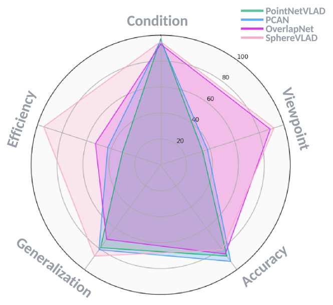
VI-B Star-diagram Evaluation
Recall the significant challenges in Section. II, the properties of place recognition are based on different factors, i.e., condition-invariant property, viewpoint-invariant property, recognition accuracy, inference efficiency, and generalization ability. Since place recognition in the real world is a complete task, and evaluate property only on accuracy can not fully indicate the actual performance. In previous relative benchmark [69], the performance of PR methods is mainly evaluated on specific datasets, and there misses a fair quality and qualitative analysis on particular properties. As shown in Fig. 10, we provide a star-diagram evaluation template to investigate the performance of the place recognition on,
-
•
Condition Invariant Property: under fixed viewpoints and given sensor inputs, we analyze the place recognition accuracy (Recall rates at Top-N retrievals) under different environmental conditions (illuminations, weather, etc.)
-
•
Viewpoint Invariant Property: under fixed environmental conditions and given sensor inputs, we evaluate the distributions of place recall rates Top-N under different combinations of local translation/orientation differences.
-
•
Recognition Accuracy: under fixed environmental conditions and different local viewpoints, we analyze the final localization error (Euclidean distances) distributions of various environments near the training scenarios.
-
•
Generalization ability: under fixed environmental conditions and viewpoints, we analyze the place recognition recall rates at top-N retrievals on the unknown areas after training the network model on a fixed given dataset.
-
•
Inference Efficiency: time is one of the essential factors in real-work place recognition applications; we also explore the feature extraction time and place recognition time.
VI-C Supported Libraries
In the recent years, there also emerge lots of well maintained libraries [120, 169, 170, 171, 172, 157, 158] to help develop long-term place recognition systems. OpenSeqSLAM2.0 [120] gives a comprehensively characterizing analysis of the critical components of SeqSLAM, which helps to investigate how to maximize the performance of sequence matching. VPR-Bench [170] provide 12 fully-integrated datasets, 10 VPR techniques, and a set of VPR evaluation metrics to help make the comparison for new methods. Kapture [169] is an open toolbox with an extendable data format for visual localization and structure-from-motion evaluation, which enable the VPR developments with variant requirements. And as an extension of Kapture, Kapture-localization [172] provides a basic localization template and can combine with different place recognition algorithms. LT-mapper [171] provide a uniform lifelong mapping framework for LiDAR SLAM, which includes multi-session mapping and long-term map managements. The LT-mapper’s modular design allows it to be easily combined with new custom place descriptors. ALITA [158] provides the tool box for city- and campus- scale datasets, which can evaluate: 1) large-scale place recognition, 2) multi-session map merging, 3) cross-domain place recognition, and 4) long-term lifelong localization. And ALTO [157] provides the open toolbox for accessing google satellite images for raw visual inputs from UAV to evaluate large-scale visual terrain relative navigation.
VII Conclusion
As stated in [173], simultaneous localization and mapping (SLAM) plays an essential role in mobile robotic development. However, while the well-known visual place recognition survey paper [1] was published years ago, visual-, LiDAR-, and Radar-based place recognition and re-localization methods are still unsuccessfully applied in long-term navigation systems under varying environments. This survey paper aims to provide a detailed review on the most recent long-term place recognition methods. We revisit the definition of ‘Place Recognition’ and highlight the current promising sensor modalities, major solutions for existing challenges, potential applications, trends based on reliable place recognition techniques, and publicly available datasets and libraries for long-term localization development.
With the recent development of new sensor modalities, place feature extraction from new types of sensors (high-resolution LiDAR, 360-degree camera, Radar devices) inputs have significantly improved the re-localization robustness under viewpoint and environmental conditions differences. Most recent combinations of multi-modal sensor inputs also provide a new direction for robust long-term place recognition approaches, which can compensate for the shortcomings of using a single sensor modality. These tradeoffs can be summarized as: 1) Visual cameras capture rich semantics and textures but are not robust to appearance changes; 2) LiDAR devices provide stable 3D geometry measurements but these are low-resolution and textureless; 3) Radar devices provide robust measurements in extreme weather and occlusions but observations are often noisy. The aforementioned different sensor configurations in Section. III, we hope, will spur new research directions in long-term real-world robotics autonomy, and will also provide a new perspective on system design for new industrial products.
Deep learning-based place feature extraction has shown great success in both single- and multi-modal systems. New types of convolution layers can be used with 360-degree sensor inputs for viewpoint-invariant place feature extraction. New domain-transfer methods also enable sim-to-real place recognition, where robots can achieve hundreds of kilometers of re-localization with only a few kilometers of training data trajectories. And a new type of data association mechanism, i.e., transformer networks and loss metrics, also enhances feature aggregation ability for more accurate re-localization. And, most importantly, the increased computing power and efficiency of embedded GPUs also make online feature extraction and place re-localization achievable in real-time and in low-power consumption platforms (i.e., low-cost UGVs and UAVs). Based on the analysis of current solutions for long-term place recognition in Section. IV, there is still lots of space and lots of opportunities for research into generalizable place recognition approaches.
So, what can a place recognition system bring to real-world robotic research? As analyzed in Section. V, reliable place recognition approaches can enable long-term navigation for mobile robots in city- and campus-scale environments under challenging conditions, in complicated indoor environments with illumination variations, and even in extreme underground environments with unstructured 3D geometries; it can also assist with positioning systems for UAVs with the aid of publicly available satellite images, especially for space exploration (i.e., Mars, Moon), where a GPS is unavailable. Additionally, reliable place recognition can provide stable data association across different sensor modalities or long-term time domains. This property can provide low-cost Radar-localization on accurate 3D LiDAR maps and wearable visual localization systems for Augmented reality and virtual reality applications. Further, with the recent developments in multi-agent systems, place recognition can also boost multi-agent cooperation in exploration and scene understanding. Finally, given that the data-association ability of place recognition can build on place connections in both the spatial and temporal domains, it can be used to help give robots lifelong navigation and continual perception abilities for real-world applications.
In Section. VI, we investigate the current publicly available datasets for long-term place recognition and provide our datasets and an evaluation benchmark to promote further research in this area. As a community, we can further analyze new place recognition methods under different localization constraints to investigate whether or not they are suitable for real-world challenging navigation tasks. This paper takes a sizable step toward long-term general autonomy and provides guidance in that direction.
VIII Acknowledgment
This research was supported by grants from NVIDIA and utilized NVIDIA SDKs (CUDA Toolkit, TensorRT, and Omniverse). This research was also supported by ARL grant NO.W911QX20D0008 and Mitsubishi Heavy Industries under grant NO.00003865.
References
- [1] C. Cadena, L. Carlone, H. Carrillo, Y. Latif, D. Scaramuzza, J. Neira, I. Reid, and J. J. Leonard, “Past, present, and future of simultaneous localization and mapping: Toward the robust-perception age,” IEEE Transactions on Robotics, vol. 32, no. 6, pp. 1309–1332, 2016.
- [2] X. Zhang, L. Wang, and Y. Su, “Visual place recognition: A survey from deep learning perspective,” Pattern Recognition, vol. 113, p. 107760, 2021.
- [3] T. Barros, R. Pereira, L. Garrote, C. Premebida, and U. J. Nunes, “Place recognition survey: An update on deep learning approaches,” 2021.
- [4] S. Garg, T. Fischer, and M. Milford, “Where is your place, visual place recognition?” in Proceedings of the Thirtieth International Joint Conference on Artificial Intelligence. International Joint Conferences on Artificial Intelligence Organization, aug 2021.
- [5] H. Lategahn, A. Geiger, and B. Kitt, “Visual slam for autonomous ground vehicles,” in 2011 IEEE International Conference on Robotics and Automation, 2011, pp. 1732–1737.
- [6] W. Wang, W. Zhao, X. Wang, Z. Jin, Y. Li, and T. Runge, “A low-cost simultaneous localization and mapping algorithm for last-mile indoor delivery,” in 2019 5th International Conference on Transportation Information and Safety (ICTIS), 2019, pp. 329–336.
- [7] A. T. Fragoso, C. T. Lee, A. S. McCoy, and S.-J. Chung, “A seasonally invariant deep transform for visual terrain-relative navigation,” Science Robotics, vol. 6, no. 55, p. eabf3320, 2021.
- [8] B. Grelsson, A. Robinson, M. Felsberg, and F. S. Khan, “Gps-level accurate camera localization with horizonnet,” Journal of Field Robotics, vol. 37, no. 6, pp. 951–971, 2020.
- [9] D. Van Opdenbosch and E. Steinbach, “Collaborative visual slam using compressed feature exchange,” IEEE Robotics and Automation Letters, vol. 4, no. 1, pp. 57–64, 2019.
- [10] A. Rosinol, M. Abate, Y. Chang, and L. Carlone, “Kimera: an open-source library for real-time metric-semantic localization and mapping,” in IEEE Intl. Conf. on Robotics and Automation (ICRA), 2020.
- [11] K. MacTavish, M. Paton, and T. D. Barfoot, “Visual triage: A bag-of-words experience selector for long-term visual route following,” in 2017 IEEE International Conference on Robotics and Automation (ICRA), 2017, pp. 2065–2072.
- [12] A.-D. Doan, Y. Latif, T.-J. Chin, and I. Reid, “Hm4: Hidden markov model with memory management for visual place recognition,” IEEE Robotics and Automation Letters, vol. 6, no. 1, pp. 167–174, 2021.
- [13] J. O’Keefe, “Place units in the hippocampus of the freely moving rat,” Experimental neurology, vol. 51, no. 1, pp. 78–109, 1976.
- [14] T. Weyand, A. Araujo, B. Cao, and J. Sim, “Google landmarks dataset v2 – a large-scale benchmark for instance-level recognition and retrieval,” in 2020 IEEE/CVF Conference on Computer Vision and Pattern Recognition (CVPR), 2020, pp. 2572–2581.
- [15] A. Yang, Y. Luo, L. Chen, and Y. Xu, “Survey of 3d map in slam: Localization and navigation,” in Advanced Computational Methods in Life System Modeling and Simulation,LSMS 2017, PT I, ser. Communications in Computer and Information Science, vol. 761, 2017, pp. 410–420.
- [16] M. Zaffar, S. Ehsan, M. Milford, and K. McDonald-Maier, “Cohog: A light-weight, compute-efficient, and training-free visual place recognition technique for changing environments,” IEEE Robotics and Automation Letters, vol. 5, no. 2, pp. 1835–1842, 2020.
- [17] A. Oertel, T. Cieslewski, and D. Scaramuzza, “Augmenting visual place recognition with structural cues,” IEEE Robotics and Automation Letters, vol. 5, no. 4, pp. 5534–5541, 2020.
- [18] A. Khaliq, S. Ehsan, Z. Chen, M. Milford, and K. McDonald-Maier, “A holistic visual place recognition approach using lightweight cnns for significant viewpoint and appearance changes,” IEEE Transactions on Robotics, vol. 36, no. 2, pp. 561–569, 2020.
- [19] X. Ye and J. Ma, “Visual place recognition via local affine preserving matching,” in 2021 IEEE International Conference on Robotics and Automation (ICRA), 2021, pp. 12 954–12 960.
- [20] A. Ozdemir, M. Scerri, A. B. Barron, A. Philippides, M. Mangan, E. Vasilaki, and L. Manneschi, “Echovpr: Echo state networks for visual place recognition,” IEEE Robotics and Automation Letters, vol. 7, no. 2, pp. 4520–4527, 2022.
- [21] T. L. Molloy, T. Fischer, M. Milford, and G. N. Nair, “Intelligent reference curation for visual place recognition via bayesian selective fusion,” IEEE Robotics and Automation Letters, vol. 6, no. 2, pp. 588–595, 2021.
- [22] G. Peng, Y. Yue, J. Zhang, Z. Wu, X. Tang, and D. Wang, “Semantic reinforced attention learning for visual place recognition,” in 2021 IEEE International Conference on Robotics and Automation (ICRA), 2021, pp. 13 415–13 422.
- [23] F. Lu, B. Chen, X.-D. Zhou, and D. Song, “Sta-vpr: Spatio-temporal alignment for visual place recognition,” IEEE Robotics and Automation Letters, vol. 6, no. 3, pp. 4297–4304, 2021.
- [24] M. Waheed, M. Milford, K. McDonald-Maier, and S. Ehsan, “Improving visual place recognition performance by maximising complementarity,” IEEE Robotics and Automation Letters, vol. 6, no. 3, pp. 5976–5983, 2021.
- [25] A. Khaliq, M. Milford, and S. Garg, “Multires-netvlad: Augmenting place recognition training with low-resolution imagery,” IEEE Robotics and Automation Letters, vol. 7, no. 2, pp. 3882–3889, 2022.
- [26] F. Yuan, P. Neubert, S. Schubert, and P. Protzel, “Softmp: Attentive feature pooling for joint local feature detection and description for place recognition in changing environments,” in 2021 IEEE International Conference on Robotics and Automation (ICRA), 2021, pp. 5847–5853.
- [27] N. Piasco, D. Sidibé, V. Gouet-Brunet, and C. Demonceaux, “Improving image description with auxiliary modality for visual localization in challenging conditions,” International Journal of Computer Vision, vol. 129, no. 1, pp. 185–202, 2021.
- [28] J. Mo and J. Sattar, “A fast and robust place recognition approach for stereo visual odometry using lidar descriptors,” in 2020 IEEE/RSJ International Conference on Intelligent Robots and Systems (IROS), 2020, pp. 5893–5900.
- [29] A. J. Lee and A. Kim, “Eventvlad: Visual place recognition with reconstructed edges from event cameras,” in 2021 IEEE/RSJ International Conference on Intelligent Robots and Systems (IROS), 2021, pp. 2247–2252.
- [30] P. Yin, L. Xu, J. Zhang, H. Choset, and S. Scherer, “i3dloc: Image-to-range cross-domain localization robust to inconsistent environmental conditions,” 2021.
- [31] S. Yoon, S. Park, S. Ahn, H. Hwang, and K. S. Roh, “Robust place recognition by spectral graph matching using omni-directional images,” in 2014 IEEE/ASME International Conference on Advanced Intelligent Mechatronics, 2014, pp. 1527–1532.
- [32] K. Lee, S. Lee, W. J. Jung, and K. T. Kim, “Fast and accurate visual place recognition using street-view images,” ETRI Journal, vol. 39, no. 1, pp. 97–107, 2017.
- [33] N. Zioulis, F. Alvarez, D. Zarpalas, and P. Daras, “Single-shot cuboids: Geodesics-based end-to-end manhattan aligned layout estimation from spherical panoramas,” Image and Vision Computing, vol. 110, p. 104160, 2021.
- [34] Y. Zhang and F. Huang, “Panoramic visual slam technology for spherical images,” Sensors, vol. 21, no. 3, 2021.
- [35] T. Stone, D. Differt, M. Milford, and B. Webb, “Skyline-based localisation for aggressively manoeuvring robots using uv sensors and spherical harmonics,” in 2016 IEEE International Conference on Robotics and Automation (ICRA), 2016, pp. 5615–5622.
- [36] L. Liu and H. Li, “Lending orientation to neural networks for cross-view geo-localization,” in 2019 IEEE/CVF Conference on Computer Vision and Pattern Recognition (CVPR), 2019, pp. 5617–5626.
- [37] G. Kim and A. Kim, “Scan context: Egocentric spatial descriptor for place recognition within 3d point cloud map,” in 2018 IEEE/RSJ International Conference on Intelligent Robots and Systems (IROS), 2018, pp. 4802–4809.
- [38] J. Guo, P. V. K. Borges, C. Park, and A. Gawel, “Local descriptor for robust place recognition using lidar intensity,” IEEE Robotics and Automation Letters, vol. 4, no. 2, pp. 1470–1477, 2019.
- [39] Y. Zhu, Y. Ma, L. Chen, C. Liu, M. Ye, and L. Li, “Gosmatch: Graph-of-semantics matching for detecting loop closures in 3d lidar data,” in 2020 IEEE/RSJ International Conference on Intelligent Robots and Systems (IROS), 2020, pp. 5151–5157.
- [40] S. Siva, Z. Nahman, and H. Zhang, “Voxel-based representation learning for place recognition based on 3d point clouds,” in 2020 IEEE/RSJ International Conference on Intelligent Robots and Systems (IROS), 2020, pp. 8351–8357.
- [41] G. Kim, Y. S. Park, Y. Cho, J. Jeong, and A. Kim, “Mulran: Multimodal range dataset for urban place recognition,” in 2020 IEEE International Conference on Robotics and Automation (ICRA), 2020, pp. 6246–6253.
- [42] D. Rozenberszki and A. L. Majdik, “Lol: Lidar-only odometry and localization in 3d point cloud maps,” in 2020 IEEE International Conference on Robotics and Automation (ICRA), 2020, pp. 4379–4385.
- [43] J. Komorowski, “Minkloc3d: Point cloud based large-scale place recognition,” in 2021 IEEE Winter Conference on Applications of Computer Vision (WACV), 2021, pp. 1789–1798.
- [44] K. Żywanowski, A. Banaszczyk, M. R. Nowicki, and J. Komorowski, “Minkloc3d-si: 3d lidar place recognition with sparse convolutions, spherical coordinates, and intensity,” IEEE Robotics and Automation Letters, vol. 7, no. 2, pp. 1079–1086, 2022.
- [45] G. Kim, S. Choi, and A. Kim, “Scan context++: Structural place recognition robust to rotation and lateral variations in urban environments,” IEEE Transactions on Robotics, vol. 38, no. 3, pp. 1856–1874, 2022.
- [46] P. Yin, L. Xu, Z. Feng, A. Egorov, and B. Li, “Pse-match: A viewpoint-free place recognition method with parallel semantic embedding,” IEEE Transactions on Intelligent Transportation Systems, pp. 1–12, 2021.
- [47] P. Yin, F. Wang, A. Egorov, J. Hou, Z. Jia, and J. Han, “Fast sequence-matching enhanced viewpoint-invariant 3-d place recognition,” IEEE Transactions on Industrial Electronics, vol. 69, no. 2, pp. 2127–2135, 2022.
- [48] K. Vidanapathirana, P. Moghadam, B. Harwood, M. Zhao, S. Sridharan, and C. Fookes, “Locus: Lidar-based place recognition using spatiotemporal higher-order pooling,” in 2021 IEEE International Conference on Robotics and Automation (ICRA), 2021, pp. 5075–5081.
- [49] P. Yin, L. Xu, J. Zhang, and H. Choset, “Fusionvlad: A multi-view deep fusion networks for viewpoint-free 3d place recognition,” IEEE Robotics and Automation Letters, vol. 6, no. 2, pp. 2304–2310, 2021.
- [50] Y. Xie, Y. Zhang, L. Chen, H. Cheng, W. Tu, D. Cao, and Q. Li, “Rdc-slam: A real-time distributed cooperative slam system based on 3d lidar,” IEEE Transactions on Intelligent Transportation Systems, pp. 1–10, 2021.
- [51] L. Li, X. Kong, X. Zhao, T. Huang, W. Li, F. Wen, H. Zhang, and Y. Liu, “Rinet: Efficient 3d lidar-based place recognition using rotation invariant neural network,” IEEE Robotics and Automation Letters, vol. 7, no. 2, pp. 4321–4328, 2022.
- [52] K. Vidanapathirana, M. Ramezani, P. Moghadam, S. Sridharan, and C. Fookes, “Logg3d-net: Locally guided global descriptor learning for 3d place recognition,” in 2022 International Conference on Robotics and Automation (ICRA), 2022, pp. 2215–2221.
- [53] J. Lin and F. Zhang, “A fast, complete, point cloud based loop closure for lidar odometry and mapping,” arXiv preprint arXiv:1909.11811, 2019.
- [54] Y. Wang, Y. Lou, Y. Zhang, W. Song, F. Huang, and Z. Tu, “A robust framework for simultaneous localization and mapping with multiple non-repetitive scanning lidars,” Remote Sensing, vol. 13, no. 10, 2021.
- [55] M. Gadd, D. De Martini, and P. Newman, “Look around you: Sequence-based radar place recognition with learned rotational invariance,” in 2020 IEEE/ION Position, Location and Navigation Symposium (PLANS), 2020, pp. 270–276.
- [56] T. Y. Tang, D. D. Martini, S. Wu, and P. Newman, “Self-supervised learning for using overhead imagery as maps in outdoor range sensor localization,” The International Journal of Robotics Research, vol. 40, no. 12-14, pp. 1488–1509, 2021, pMID: 34992328.
- [57] S. Saftescu, M. Gadd, D. De Martini, D. Barnes, and P. Newman, “Kidnapped radar: Topological radar localisation using rotationally-invariant metric learning,” in 2020 IEEE International Conference on Robotics and Automation (ICRA), 2020, pp. 4358–4364.
- [58] M. Gadd, D. De Martini, and P. Newman, “Contrastive learning for unsupervised radar place recognition,” in 2021 20th International Conference on Advanced Robotics (ICAR), 2021, pp. 344–349.
- [59] K. Cait, B. Wang, and C. X. Lu, “Autoplace: Robust place recognition with single-chip automotive radar,” in 2022 International Conference on Robotics and Automation (ICRA), 2022, pp. 2222–2228.
- [60] A. Geiger, P. Lenz, and R. Urtasun, “Are we ready for autonomous driving? the kitti vision benchmark suite,” in 2012 IEEE Conference on Computer Vision and Pattern Recognition, 2012, pp. 3354–3361.
- [61] H. Yin, R. Chen, Y. Wang, and R. Xiong, “Rall: End-to-end radar localization on lidar map using differentiable measurement model,” IEEE Transactions on Intelligent Transportation Systems, vol. 23, no. 7, pp. 6737–6750, 2022.
- [62] Z. Hong, Y. Petillot, A. Wallace, and S. Wang, “Radarslam: A robust simultaneous localization and mapping system for all weather conditions,” The International Journal of Robotics Research, vol. 41, no. 5, pp. 519–542, 2022.
- [63] L. Di Giammarino, I. Aloise, C. Stachniss, and G. Grisetti, “Visual place recognition using lidar intensity information,” in 2021 IEEE/RSJ International Conference on Intelligent Robots and Systems (IROS), 2021, pp. 4382–4389.
- [64] T. Shan, B. Englot, F. Duarte, C. Ratti, and D. Rus, “Robust place recognition using an imaging lidar,” in 2021 IEEE International Conference on Robotics and Automation (ICRA). IEEE, 2021, pp. 5469–5475.
- [65] X. Yu, B. Zhou, Z. Chang, K. Qian, and F. Fang, “Mmdf: Multi-modal deep feature based place recognition of mobile robots with applications on cross-scene navigation,” IEEE Robotics and Automation Letters, vol. 7, no. 3, pp. 6742–6749, 2022.
- [66] L. Bernreiter, L. Ott, J. Nieto, R. Siegwart, and C. Cadena, “Spherical multi-modal place recognition for heterogeneous sensor systems,” in 2021 IEEE International Conference on Robotics and Automation (ICRA), 2021, pp. 1743–1750.
- [67] D. Cattaneo, M. Vaghi, S. Fontana, A. L. Ballardini, and D. G. Sorrenti, “Global visual localization in lidar-maps through shared 2d-3d embedding space,” in 2020 IEEE International Conference on Robotics and Automation (ICRA), 2020, pp. 4365–4371.
- [68] H. Lai, P. Yin, and S. Scherer, “Adafusion: Visual-lidar fusion with adaptive weights for place recognition,” 2021.
- [69] M. Zaffar, S. Garg, M. Milford, J. Kooij, D. Flynn, K. McDonald-Maier, and S. Ehsan, “VPR-bench: An open-source visual place recognition evaluation framework with quantifiable viewpoint and appearance change,” International Journal of Computer Vision., vol. 129, no. 7, pp. 2136–2174, May 2021.
- [70] P.-E. Sarlin, C. Cadena, R. Siegwart, and M. Dymczyk, “From coarse to fine: Robust hierarchical localization at large scale,” in 2019 IEEE/CVF Conference on Computer Vision and Pattern Recognition (CVPR), 2019, pp. 12 708–12 717.
- [71] H. Jaeger, M. Lukoševičius, D. Popovici, and U. Siewert, “Optimization and applications of echo state networks with leaky- integrator neurons,” Neural Networks, vol. 20, no. 3, pp. 335–352, 2007, echo State Networks and Liquid State Machines.
- [72] D. Scaramuzza, Omnidirectional Camera. Boston, MA: Springer US, 2014, pp. 552–560.
- [73] C. Esteves, C. Allen-Blanchette, A. Makadia, and K. Daniilidis, “Learning so(3) equivariant representations with spherical cnns,” International Journal of Computer Vision, vol. 128, no. 2, pp. 588–600, 2020.
- [74] F. Moosmann and C. Stiller, “Velodyne slam,” in 2011 IEEE Intelligent Vehicles Symposium (IV), 2011, pp. 393–398.
- [75] J. Lin and F. Zhang, “Loam livox: A fast, robust, high-precision lidar odometry and mapping package for lidars of small fov,” in 2020 IEEE International Conference on Robotics and Automation (ICRA), 2020, pp. 3126–3131.
- [76] M. A. Uy and G. H. Lee, “Pointnetvlad: Deep point cloud based retrieval for large-scale place recognition,” in 2018 IEEE/CVF Conference on Computer Vision and Pattern Recognition, 2018, pp. 4470–4479.
- [77] R. Q. Charles, H. Su, M. Kaichun, and L. J. Guibas, “Pointnet: Deep learning on point sets for 3d classification and segmentation,” in 2017 IEEE Conference on Computer Vision and Pattern Recognition (CVPR), 2017, pp. 77–85.
- [78] R. Arandjelovic, P. Gronat, A. Torii, T. Pajdla, and J. Sivic, “Netvlad: Cnn architecture for weakly supervised place recognition,” in 2016 IEEE Conference on Computer Vision and Pattern Recognition (CVPR), 2016, pp. 5297–5307.
- [79] W. Zhang and C. Xiao, “Pcan: 3d attention map learning using contextual information for point cloud based retrieval,” in 2019 IEEE/CVF Conference on Computer Vision and Pattern Recognition (CVPR), 2019, pp. 12 428–12 437.
- [80] A. Vaswani, N. Shazeer, N. Parmar, J. Uszkoreit, L. Jones, A. N. Gomez, L. Kaiser, and I. Polosukhin, “Attention is all you need,” in Proceedings of the 31st International Conference on Neural Information Processing Systems, ser. NIPS’17. Red Hook, NY, USA: Curran Associates Inc., 2017, p. 6000–6010.
- [81] Z. Liu, S. Zhou, C. Suo, P. Yin, W. Chen, H. Wang, H. Li, and Y. Liu, “Lpd-net: 3d point cloud learning for large-scale place recognition and environment analysis,” in 2019 IEEE/CVF International Conference on Computer Vision (ICCV), 2019, pp. 2831–2840.
- [82] L. He, X. Wang, and H. Zhang, “M2dp: A novel 3d point cloud descriptor and its application in loop closure detection,” in 2016 IEEE/RSJ International Conference on Intelligent Robots and Systems (IROS), 2016, pp. 231–237.
- [83] E. Rublee, V. Rabaud, K. Konolige, and G. Bradski, “Orb: An efficient alternative to sift or surf,” in 2011 International Conference on Computer Vision, 2011, pp. 2564–2571.
- [84] K. A. Tsintotas, P. Giannis, L. Bampis, and A. Gasteratos, “Appearance-based loop closure detection with scale-restrictive visual features,” in Computer Vision Systems, D. Tzovaras, D. Giakoumis, M. Vincze, and A. Argyros, Eds. Cham: Springer International Publishing, 2019, pp. 75–87.
- [85] K. Simonyan and A. Zisserman, “Very deep convolutional networks for large-scale image recognition,” in 3rd International Conference on Learning Representations, ICLR 2015, San Diego, CA, USA, May 7-9, 2015, Conference Track Proceedings, Y. Bengio and Y. LeCun, Eds., 2015.
- [86] K. He, X. Zhang, S. Ren, and J. Sun, “Identity mappings in deep residual networks,” in European conference on computer vision. Springer, 2016, pp. 630–645.
- [87] I. Goodfellow, J. Pouget-Abadie, M. Mirza, B. Xu, D. Warde-Farley, S. Ozair, A. Courville, and Y. Bengio, “Generative adversarial nets,” Advances in neural information processing systems, vol. 27, 2014.
- [88] J.-Y. Zhu, T. Park, P. Isola, and A. A. Efros, “Unpaired image-to-image translation using cycle-consistent adversarial networks,” in 2017 IEEE International Conference on Computer Vision (ICCV), 2017, pp. 2242–2251.
- [89] S. Hausler, S. Garg, M. Xu, M. Milford, and T. Fischer, “Patch-netvlad: Multi-scale fusion of locally-global descriptors for place recognition,” in 2021 IEEE/CVF Conference on Computer Vision and Pattern Recognition (CVPR), 2021, pp. 14 136–14 147.
- [90] N. Merrill and G. Huang, “Calc2.0: Combining appearance, semantic and geometric information for robust and efficient visual loop closure,” in 2019 IEEE/RSJ International Conference on Intelligent Robots and Systems (IROS), 2019, pp. 4554–4561.
- [91] A. Krizhevsky, I. Sutskever, and G. E. Hinton, “Imagenet classification with deep convolutional neural networks,” Commun. ACM, vol. 60, no. 6, p. 84–90, may 2017.
- [92] N. Dalal and B. Triggs, “Histograms of oriented gradients for human detection,” in 2005 IEEE Computer Society Conference on Computer Vision and Pattern Recognition (CVPR’05), vol. 1, 2005, pp. 886–893 vol. 1.
- [93] A. Krizhevsky, I. Sutskever, and G. E. Hinton, “Imagenet classification with deep convolutional neural networks,” Commun. ACM, vol. 60, no. 6, p. 84–90, may 2017.
- [94] P. Yin, L. Xu, X. Li, C. Yin, Y. Li, R. A. Srivatsan, L. Li, J. Ji, and Y. He, “A multi-domain feature learning method for visual place recognition,” in 2019 International Conference on Robotics and Automation (ICRA), 2019, pp. 319–324.
- [95] M. J. Milford and G. F. Wyeth, “Seqslam: Visual route-based navigation for sunny summer days and stormy winter nights,” in 2012 IEEE International Conference on Robotics and Automation, 2012, pp. 1643–1649.
- [96] M. Cummins and P. Newman, “Fab-map: Probabilistic localization and mapping in the space of appearance,” The International Journal of Robotics Research, vol. 27, no. 6, pp. 647–665, 2008.
- [97] D. Galvez-López and J. D. Tardos, “Bags of binary words for fast place recognition in image sequences,” IEEE Transactions on Robotics, vol. 28, no. 5, pp. 1188–1197, 2012.
- [98] S. M. Siam and H. Zhang, “Fast-seqslam: A fast appearance based place recognition algorithm,” in 2017 IEEE International Conference on Robotics and Automation (ICRA), 2017, pp. 5702–5708.
- [99] L. Bampis, A. Amanatiadis, and A. Gasteratos, “Fast loop-closure detection using visual-word-vectors from image sequences,” The International Journal of Robotics Research, vol. 37, no. 1, pp. 62–82, 2018.
- [100] Z. Liu, C. Suo, S. Zhou, F. Xu, H. Wei, W. Chen, H. Wang, X. Liang, and Y.-H. Liu, “Seqlpd: Sequence matching enhanced loop-closure detection based on large-scale point cloud description for self-driving vehicles,” in 2019 IEEE/RSJ International Conference on Intelligent Robots and Systems (IROS), 2019, pp. 1218–1223.
- [101] P. Yin, R. A. Srivatsan, Y. Chen, X. Li, H. Zhang, L. Xu, L. Li, Z. Jia, J. Ji, and Y. He, “Mrs-vpr: a multi-resolution sampling based global visual place recognition method,” in 2019 International Conference on Robotics and Automation (ICRA), 2019, pp. 7137–7142.
- [102] P. Yin, F. Wang, A. Egorov, J. Hou, J. Zhang, and H. Choset, “Seqspherevlad: Sequence matching enhanced orientation-invariant place recognition,” in 2020 IEEE/RSJ International Conference on Intelligent Robots and Systems (IROS), 2020, pp. 5024–5029.
- [103] M. Chancán, L. Hernandez-Nunez, A. Narendra, A. B. Barron, and M. Milford, “A hybrid compact neural architecture for visual place recognition,” IEEE Robotics and Automation Letters, vol. 5, no. 2, pp. 993–1000, 2020.
- [104] S. Garg and M. Milford, “Seqnet: Learning descriptors for sequence-based hierarchical place recognition,” IEEE Robotics and Automation Letters, vol. 6, no. 3, pp. 4305–4312, 2021.
- [105] X. Chen, T. Läbe, A. Milioto, T. Röhling, O. Vysotska, A. Haag, J. Behley, and C. Stachniss, “Overlapnet: Loop closing for lidar-based SLAM,” CoRR, vol. abs/2105.11344, 2021.
- [106] J. Sanchez, F. Perronnin, T. Mensink, and J. Verbeek, “Image classification with the fisher vector: Theory and practice,” International journal of computer vision, vol. 105, no. 3, pp. 222–245, 2013.
- [107] R. Arandjelovic and A. Zisserman, “All about vlad,” in 2013 IEEE Conference on Computer Vision and Pattern Recognition, 2013, pp. 1578–1585.
- [108] S. Garg, N. Suenderhauf, and M. Milford, “Don’t look back: Robustifying place categorization for viewpoint- and condition-invariant place recognition,” in 2018 IEEE International Conference on Robotics and Automation (ICRA), 2018, pp. 3645–3652.
- [109] E. Garcia-Fidalgo and A. Ortiz, “ibow-lcd: An appearance-based loop-closure detection approach using incremental bags of binary words,” IEEE Robotics and Automation Letters, vol. 3, no. 4, pp. 3051–3057, 2018.
- [110] S. An, H. Zhu, D. Wei, K. A. Tsintotas, and A. Gasteratos, “Fast and incremental loop closure detection with deep features and proximity graphs,” Journal of Field Robotics, vol. 39, no. 4, pp. 473–493, 2022.
- [111] K. He, X. Zhang, S. Ren, and J. Sun, “Identity mappings in deep residual networks,” in Computer Vision – ECCV 2016, B. Leibe, J. Matas, N. Sebe, and M. Welling, Eds. Cham: Springer International Publishing, 2016, pp. 630–645.
- [112] S. Zhao, P. Yin, G. Yi, and S. Scherer, “Spherevlad++: Attention-based and signal-enhanced viewpoint invariant descriptor,” 2022.
- [113] X. Kong, X. Yang, G. Zhai, X. Zhao, X. Zeng, M. Wang, Y. Liu, W. Li, and F. Wen, “Semantic graph based place recognition for 3d point clouds,” in 2020 IEEE/RSJ International Conference on Intelligent Robots and Systems (IROS). IEEE, 2020, pp. 8216–8223.
- [114] V. Paolicelli, A. Tavera, C. Masone, G. Berton, and B. Caputo, “Learning semantics for visual place recognition through multi-scale attention,” in Image Analysis and Processing – ICIAP 2022, S. Sclaroff, C. Distante, M. Leo, G. M. Farinella, and F. Tombari, Eds. Cham: Springer International Publishing, 2022, pp. 454–466.
- [115] T. Barros, L. Garrote, R. Pereira, C. Premebida, and U. J. Nunes, “Attdlnet: Attention-based dl network for 3d lidar place recognition,” 2021.
- [116] G. Kurz, M. Holoch, and P. Biber, “Geometry-based graph pruning for lifelong slam,” in 2021 IEEE/RSJ International Conference on Intelligent Robots and Systems (IROS), 2021, pp. 3313–3320.
- [117] R. Mur-Artal, J. M. M. Montiel, and J. D. Tardós, “Orb-slam: A versatile and accurate monocular slam system,” IEEE Transactions on Robotics, vol. 31, no. 5, pp. 1147–1163, 2015.
- [118] T. Qin, P. Li, and S. Shen, “Vins-mono: A robust and versatile monocular visual-inertial state estimator,” IEEE Transactions on Robotics, vol. 34, no. 4, pp. 1004–1020, 2018.
- [119] E. Pepperell, P. I. Corke, and M. J. Milford, “All-environment visual place recognition with smart,” in 2014 IEEE International Conference on Robotics and Automation (ICRA), 2014, pp. 1612–1618.
- [120] B. Talbot, S. Garg, and M. Milford, “Openseqslam2.0: An open source toolbox for visual place recognition under changing conditions,” in 2018 IEEE/RSJ International Conference on Intelligent Robots and Systems (IROS), 2018, pp. 7758–7765.
- [121] Y. Liu and H. Zhang, “Towards improving the efficiency of sequence-based slam,” in 2013 IEEE International Conference on Mechatronics and Automation, 2013, pp. 1261–1266.
- [122] S. M. Siam and H. Zhang, “Fast-seqslam: A fast appearance based place recognition algorithm,” in 2017 IEEE International Conference on Robotics and Automation (ICRA), 2017, pp. 5702–5708.
- [123] P. Hansen and B. Browning, “Visual place recognition using hmm sequence matchingv,” in 2014 IEEE/RSJ International Conference on Intelligent Robots and Systems, 2014, pp. 4549–4555.
- [124] K. A. Tsintotas, L. Bampis, and A. Gasteratos, “Doseqslam: Dynamic on-line sequence based loop closure detection algorithm for slam,” in 2018 IEEE International Conference on Imaging Systems and Techniques (IST), 2018, pp. 1–6.
- [125] R. Arroyo, P. F. Alcantarilla, L. M. Bergasa, and E. Romera, “Towards life-long visual localization using an efficient matching of binary sequences from images,” in 2015 IEEE International Conference on Robotics and Automation (ICRA), 2015, pp. 6328–6335.
- [126] G. Xiang, Y. Huang, J. Yu, M. Zhu, and J. Su, “Intelligence evolution for service robot: An adrc perspective,” Control Theory and Technology, vol. 16, no. 4, pp. 324–335, 2018.
- [127] D. Sheng, Y. Chai, X. Li, C. Feng, J. Lin, C. Silva, and J.-R. Rizzo, “Nyu-vpr: Long-term visual place recognition benchmark with view direction and data anonymization influences,” in 2021 IEEE/RSJ International Conference on Intelligent Robots and Systems (IROS), 2021, pp. 9773–9779.
- [128] A. Torii, R. Arandjelović, J. Sivic, M. Okutomi, and T. Pajdla, “24/7 place recognition by view synthesis,” in 2015 IEEE Conference on Computer Vision and Pattern Recognition (CVPR), 2015, pp. 1808–1817.
- [129] T. Y. Tang, D. De Martini, S. Wu, and P. Newman, “Self-supervised localisation between range sensors and overhead imagery,” 2020.
- [130] D. Mishkin, M. Perdoch, and J. Matas, “Place recognition with wxbs retrieval,” in CVPR 2015 workshop on visual place recognition in changing environments, vol. 30, 2015.
- [131] H. Jégou, F. Perronnin, M. Douze, J. Sánchez, P. Pérez, and C. Schmid, “Aggregating local image descriptors into compact codes,” IEEE Transactions on Pattern Analysis and Machine Intelligence, vol. 34, no. 9, pp. 1704–1716, Sept 2012.
- [132] B. Patel, T. D. Barfoot, and A. P. Schoellig, “Visual localization with google earth images for robust global pose estimation of uavs,” in 2020 IEEE International Conference on Robotics and Automation (ICRA). IEEE, 2020, pp. 6491–6497.
- [133] M. Bianchi and T. D. Barfoot, “Uav localization using autoencoded satellite images,” IEEE Robotics and Automation Letters, vol. 6, no. 2, pp. 1761–1768, 2021.
- [134] G. Baatz, O. Saurer, K. Köser, and M. Pollefeys, “Large scale visual geo-localization of images in mountainous terrain,” in Computer Vision – ECCV 2012, A. Fitzgibbon, S. Lazebnik, P. Perona, Y. Sato, and C. Schmid, Eds. Berlin, Heidelberg: Springer Berlin Heidelberg, 2012, pp. 517–530.
- [135] G. Baatz, O. Saurer, K. Köser, and M. Pollefeys, “Leveraging topographic maps for image to terrain alignment,” in 2012 Second International Conference on 3D Imaging, Modeling, Processing, Visualization Transmission, 2012, pp. 487–492.
- [136] T. Sasaki, K. Otsu, R. Thakker, S. Haesaert, and A.-a. Agha-mohammadi, “Where to map? iterative rover-copter path planning for mars exploration,” IEEE Robotics and Automation Letters, vol. 5, no. 2, pp. 2123–2130, 2020.
- [137] K. Ebadi, Y. Chang, M. Palieri, A. Stephens, A. Hatteland, E. Heiden, A. Thakur, N. Funabiki, B. Morrell, S. Wood, L. Carlone, and A.-a. Agha-mohammadi, “Lamp: Large-scale autonomous mapping and positioning for exploration of perceptually-degraded subterranean environments,” in 2020 IEEE International Conference on Robotics and Automation (ICRA), 2020, pp. 80–86.
- [138] J. G. Mangelson, D. Dominic, R. M. Eustice, and R. Vasudevan, “Pairwise consistent measurement set maximization for robust multi-robot map merging,” in 2018 IEEE International Conference on Robotics and Automation (ICRA), 2018, pp. 2916–2923.
- [139] Y. Tian, Y. Chang, F. H. Arias, C. Nieto-Granda, J. P. How, and L. Carlone, “Kimera-multi: Robust, distributed, dense metric-semantic slam for multi-robot systems,” IEEE Transactions on Robotics, pp. 1–17, 2022.
- [140] M. Labbé and F. Michaud, “Rtab-map as an open-source lidar and visual simultaneous localization and mapping library for large-scale and long-term online operation,” Journal of Field Robotics, vol. 36, no. 2, pp. 416–446, 2019.
- [141] P. Yin, H. Lai, S. Zhao, R. Fu, I. Cisneros, R. Ge, J. Zhang, H. Choset, and S. Scherer, “Automerge: A framework for map assembling and smoothing in city-scale environments,” 2022.
- [142] A. Witze et al., “Nasa has launched the most ambitious mars rover ever built: Here’s what happens next,” Nature, vol. 584, no. 7819, pp. 15–16, 2020.
- [143] L. Ding, R. Zhou, Y. Yuan, H. Yang, J. Li, T. Yu, C. Liu, J. Wang, S. Li, H. Gao, Z. Deng, N. Li, Z. Wang, Z. Gong, G. Liu, J. Xie, S. Wang, Z. Rong, D. Deng, X. Wang, S. Han, W. Wan, L. Richter, L. Huang, S. Gou, Z. Liu, H. Yu, Y. Jia, B. Chen, Z. Dang, K. Zhang, L. Li, X. He, S. Liu, and K. Di, “A 2-year locomotive exploration and scientific investigation of the lunar farside by the yutu-2 rover,” Science Robotics, vol. 7, no. 62, p. eabj6660, 2022.
- [144] M. De Lange, R. Aljundi, M. Masana, S. Parisot, X. Jia, A. Leonardis, G. Slabaugh, and T. Tuytelaars, “A continual learning survey: Defying forgetting in classification tasks,” IEEE Transactions on Pattern Analysis and Machine Intelligence, vol. 44, no. 7, pp. 3366–3385, 2022.
- [145] T. Lesort, V. Lomonaco, A. Stoian, D. Maltoni, D. Filliat, and N. D. Rodríguez, “Continual learning for robotics,” ArXiv, vol. abs/1907.00182, 2019.
- [146] G. D. Tipaldi, D. Meyer-Delius, and W. Burgard, “Lifelong localization in changing environments,” The International Journal of Robotics Research, vol. 32, no. 14, pp. 1662–1678, 2013.
- [147] M. Zhao, X. Guo, L. Song, B. Qin, X. Shi, G. H. Lee, and G. Sun, “A general framework for lifelong localization and mapping in changing environment,” in 2021 IEEE/RSJ International Conference on Intelligent Robots and Systems (IROS), 2021, pp. 3305–3312.
- [148] S. Zhu, X. Zhang, S. Guo, J. Li, and H. Liu, “Lifelong localization in semi-dynamic environment,” in 2021 IEEE International Conference on Robotics and Automation (ICRA), 2021, pp. 14 389–14 395.
- [149] D. Dall’Osto, T. Fischer, and M. Milford, “Fast and robust bio-inspired teach and repeat navigation,” in 2021 IEEE/RSJ International Conference on Intelligent Robots and Systems (IROS), 2021, pp. 500–507.
- [150] N. Sünderhauf, P. Neubert, and P. Protzel, “Are we there yet? challenging seqslam on a 3000 km journey across all four seasons,” in Proc. of workshop on long-term autonomy, IEEE international conference on robotics and automation (ICRA), 2013, p. 2013.
- [151] A. Geiger, P. Lenz, C. Stiller, and R. Urtasun, “Vision meets robotics: The kitti dataset,” The International Journal of Robotics Research, vol. 32, no. 11, pp. 1231–1237, 2013.
- [152] N. Carlevaris-Bianco, A. K. Ushani, and R. M. Eustice, “University of michigan north campus long-term vision and lidar dataset,” The International Journal of Robotics Research, vol. 35, no. 9, pp. 1023–1035, 2016.
- [153] W. Maddern, G. Pascoe, C. Linegar, and P. Newman, “1 year, 1000 km: The oxford robotcar dataset,” The International Journal of Robotics Research, vol. 36, no. 1, pp. 3–15, 2017.
- [154] F. Warburg, S. Hauberg, M. López-Antequera, P. Gargallo, Y. Kuang, and J. Civera, “Mapillary street-level sequences: A dataset for lifelong place recognition,” in 2020 IEEE/CVF Conference on Computer Vision and Pattern Recognition (CVPR), 2020, pp. 2623–2632.
- [155] Y. Liao, J. Xie, and A. Geiger, “KITTI-360: A novel dataset and benchmarks for urban scene understanding in 2d and 3d,” CoRR, vol. abs/2109.13410, 2021.
- [156] Y. Liu, W. Gao, and Z. Hu, “A large-scale dataset for indoor visual localization with high-precision ground truth,” The International Journal of Robotics Research, vol. 41, no. 2, pp. 129–135, 2022.
- [157] C. Ivan, P. Yin, J. Zhang, H. Choset, and S. Scherer, “Alto: A large-scale dataset for uav visual place recognition and localization,” arXiv preprint arXiv:2205.30737, 2022.
- [158] P. Yin, S. Zhao, R. Ge, I. Cisneros, R. Fu, J. Zhang, H. Choset, and S. Scherer, “Alita: A large-scale incremental dataset for long-term autonomy,” 2022.
- [159] Y. Kang, H. Yin, and C. Berger, “Test your self-driving algorithm: An overview of publicly available driving datasets and virtual testing environments,” IEEE Transactions on Intelligent Vehicles, vol. 4, no. 2, pp. 171–185, 2019.
- [160] Y. S. Park, J. Jeong, Y. Shin, and A. Kim, “Radar dataset for robust localization and mapping in urban environment,” in ICRA Workshop on Dataset Generation and Benchmarking of SLAM Algorithms for Robotics and VR/AR, Montreal, 2019.
- [161] B. Yamauchi and P. Langley, “Place recognition in dynamic environments,” Journal of Robotic Systems, vol. 14, no. 2, pp. 107–120, 1997.
- [162] M. Smith, I. Baldwin, W. Churchill, R. Paul, and P. Newman, “The new college vision and laser data set,” The International Journal of Robotics Research, vol. 28, no. 5, pp. 595–599, 2009.
- [163] A. Geiger, P. Lenz, and R. Urtasun, “Are we ready for autonomous driving? the kitti vision benchmark suite,” in 2012 IEEE conference on computer vision and pattern recognition. IEEE, 2012, pp. 3354–3361.
- [164] M.-F. Chang, J. Lambert, P. Sangkloy, J. Singh, S. Bak, A. Hartnett, D. Wang, P. Carr, S. Lucey, D. Ramanan, and J. Hays, “Argoverse: 3d tracking and forecasting with rich maps,” in 2019 IEEE/CVF Conference on Computer Vision and Pattern Recognition (CVPR), 2019, pp. 8740–8749.
- [165] P. Sun, H. Kretzschmar, X. Dotiwalla, A. Chouard, V. Patnaik, P. Tsui, J. Guo, Y. Zhou, Y. Chai, B. Caine, V. Vasudevan, W. Han, J. Ngiam, H. Zhao, A. Timofeev, S. Ettinger, M. Krivokon, A. Gao, A. Joshi, Y. Zhang, J. Shlens, Z. Chen, and D. Anguelov, “Scalability in perception for autonomous driving: Waymo open dataset,” in 2020 IEEE/CVF Conference on Computer Vision and Pattern Recognition (CVPR), 2020, pp. 2443–2451.
- [166] M. Ramezani, Y. Wang, M. Camurri, D. Wisth, M. Mattamala, and M. Fallon, “The newer college dataset: Handheld lidar, inertial and vision with ground truth,” in 2020 IEEE/RSJ International Conference on Intelligent Robots and Systems (IROS), 2020, pp. 4353–4360.
- [167] M. Sheeny, E. De Pellegrin, S. Mukherjee, A. Ahrabian, S. Wang, and A. Wallace, “Radiate: A radar dataset for automotive perception in bad weather,” in 2021 IEEE International Conference on Robotics and Automation (ICRA), 2021, pp. 1–7.
- [168] X. Shi, D. Li, P. Zhao, Q. Tian, Y. Tian, Q. Long, C. Zhu, J. Song, F. Qiao, L. Song, Y. Guo, Z. Wang, Y. Zhang, B. Qin, W. Yang, F. Wang, R. H. M. Chan, and Q. She, “Are we ready for service robots? the openloris-scene datasets for lifelong slam,” in 2020 IEEE International Conference on Robotics and Automation (ICRA), 2020, pp. 3139–3145.
- [169] M. Humenberger, Y. Cabon, N. Guerin, J. Morat, V. Leroy, J. Revaud, P. Rerole, N. Pion, C. de Souza, and G. Csurka, “Robust image retrieval-based visual localization using kapture,” 2020.
- [170] M. Zaffar, S. Garg, M. Milford, J. Kooij, D. Flynn, K. McDonald-Maier, and S. Ehsan, “Vpr-bench: An open-source visual place recognition evaluation framework with quantifiable viewpoint and appearance change,” Int. J. Comput. Vision, vol. 129, no. 7, p. 2136–2174, jul 2021.
- [171] G. Kim and A. Kim, “Lt-mapper: A modular framework for lidar-based lifelong mapping,” in 2022 International Conference on Robotics and Automation (ICRA), 2022, pp. 7995–8002.
- [172] M. Humenberger, Y. Cabon, N. Pion, P. Weinzaepfel, D. Lee, N. Guérin, T. Sattler, and G. Csurka, “Investigating the role of image retrieval for visual localization: An exhaustive benchmark,” Int. J. Comput. Vision, vol. 130, no. 7, p. 1811–1836, jul 2022.
- [173] G.-Z. Yang, J. Bellingham, P. E. Dupont, P. Fischer, L. Floridi, R. Full, N. Jacobstein, V. Kumar, M. McNutt, R. Merrifield, B. J. Nelson, B. Scassellati, M. Taddeo, R. Taylor, M. Veloso, Z. L. Wang, and R. Wood, “The grand challenges of ¡i¿science robotics¡/i¿,” Science Robotics, vol. 3, no. 14, p. eaar7650, 2018.
![[Uncaptioned image]](/html/2209.04497/assets/Biography/Peng.jpg) |
Peng Yin received his Bachelor degree from Harbin Institute of Technology, Harbin, China, in 2013, and his Ph.D. degree from the University of Chinese Academy of Sciences, Beijing, in 2019. He is a research Post-doctoral with the Department of the Robotics Institute, Carnegie Mellon University, Pittsburgh, USA. His research interests include LiDAR SLAM, Place Recognition, 3D Perception, and Reinforcement Learning. Dr. Yin has served as a Reviewer for several IEEE Conferences ICRA, IROS, ACC, RSS. |
![[Uncaptioned image]](/html/2209.04497/assets/Biography/shiqi.png) |
Shiqi Zhao received his Bachelor’s degree from Dalian University of Technology, Dalian, China, in 2018, and his Master’s degree from the University of California San Diego, U.S., in 2020. He is currently working as an intern at the Robotics Institute at Carnegie Mellon University. His research interests include Place Recognition, 3D Perception, and Deep Learning. |
![[Uncaptioned image]](/html/2209.04497/assets/Biography/ivan.jpeg) |
Ivan Cisneros received his B.S. in Electrical Engineering with a minor in Computer Science from Harvard University in 2016. He worked full time at NASA-JPL on several flight projects for 3 years before starting his graduate studies at Carnegie Mellon University. He is currently working on a Master’s degree in Robotics within the Robotics Institute at CMU. His research interests include SLAM, visual localization, 3D Perception, and Deep Learning. |
![[Uncaptioned image]](/html/2209.04497/assets/Biography/Abu.jpg) |
Abulikemu Abuduweili received his B.S. in Electrical Engineering from Peking University, China, in 2017, and his M.S. in Electrical Engineering from Peking University, China, in 2020. He is currently a PhD student at Electrical Engineering and Robotics at Carnegie Mellon University, USA. His research interests include Deep Learning, Robotics, and Computer Vision. |
![[Uncaptioned image]](/html/2209.04497/assets/Biography/ghuang.jpg) |
Guoquan (Paul) Huang (Senior Member, IEEE) received the B.S. degree in automation (electrical engineering) from the University of Science and Technology Beijing, China, in 2002, and the M.Sc. and Ph.D. degrees in computer science from the University of Minnesota–Twin Cities, Minneapolis, MN, USA, in 2009 and 2012, respectively. He currently is an Associate Professor of Mechanical Engineering (ME), Computer and Information Sciences (CIS), and Electrical and Computer Engineering (ECE), at the University of Delaware (UD), where he is leading the Robot Perception and Navigation Group (RPNG). From 2012 to 2014, he was a Postdoctoral Associate with the MIT Computer Science and Artificial Intelligence Laboratory (CSAIL), Cambridge, MA, USA. His research interests focus on state estimation and spatial AI for autonomous vehicles and mobile devices, including probabilistic sensing, localization, mapping, perception and navigation of autonomous robots. Dr. Huang has received some honors and awards over the years, including the 2015 UD Research Award (UDRF), 2015 NASA DE Space Research Seed Award, 2016 NSF CRII Award, 2018 SATEC Robotics Delegation (one of ten US experts invited by ASME), 2018 Google Daydream Faculty Research Award, 2019 Google AR/VR Faculty Research Award, and the Winner for the IROS 2019 FPV Drone Racing VIO Competition. He was the recipient of the ICRA 2022 Outstanding Navigation Paper Award, and the Finalists of the RSS 2009 Best Paper Award and ICRA 2021 Best Paper Award in Robot Vision. |
![[Uncaptioned image]](/html/2209.04497/assets/Biography/milford_small.jpeg) |
Michael J. Milford (Senior Member, IEEE) received the Bachelor of Mechanical and Space Engineering degree and the Ph.D. degree in electrical engineering from The University of Queensland, Brisbane, QLD, Australia. He was a Research Fellow on the Thinking Systems Project with Queensland Brain Institute, in 2010. Since 2010, he has been a Lecturer at the Queensland University of Technology (QUT), Brisbane, QLD, Australia, where he is currently an Associate Professor and an Australian Research Council Future Fellow and the Chief Investigator of the Australian Centre of Excellence for Robotic Vision. His research interests include navigation across the fields of robotics, neuroscience, and computer vision. Dr. Milford was a recipient of an inaugural Australian Research Council Discovery Early Career Research Award in 2012. He has been a Microsoft Research Faculty Fellow since 2013. |
![[Uncaptioned image]](/html/2209.04497/assets/Biography/Changliu.jpg) |
Changliu Liu received the B.S. degree in mechanical engineering and the B.S. degree in economics from Tsinghua University, China, in 2012, the M.S. degree in mechanical engineering, and the M.A. degree in mathematics from University of California, Berkeley, U.S.A., in 2014 and 2016 respectively, and the Ph.D. degree in mechanical engineering from University of California, Berkeley, U.S.A., in 2017. She is an assistant professor at the Robotics Institute at Carnegie Mellon University. Her research interests lie in the design and verification of intelligent systems with applications to manufacturing and transportation. She received NSF Career Award, Amazon Research Award, and Ford URP Award. |
![[Uncaptioned image]](/html/2209.04497/assets/Biography/howie.jpeg) |
Howie Choset received the B.S. Eng. degree in computer science and the B.S. Econ. degree in entrepreneurial management from the University of Pennsylvania (Wharton), Philadelphia, PA, USA, both in 1990, the M.S. and Ph.D. degrees in mechanical engineering from California Institute of Technology (Caltech), Pasadena, CA, USA, in 1991 and 1996, respectively. He is currently a Professor of Robotics with the Carnegie Mellon University, Pittsburgh, PA, USA. His research group reduces complicated high dimensional problems found in robotics to low-dimensional simpler ones for design, analysis, and planning. |
![[Uncaptioned image]](/html/2209.04497/assets/Biography/basti.png) |
Sebastian Scherer received his B.S. in Computer Science, M.S. and Ph.D. in Robotics from CMU in 2004, 2007, and 2010. Sebastian Scherer is an Associate Research Professor at the Robotics Institute at Carnegie Mellon University. His research focuses on enabling autonomy for unmanned rotorcraft to operate at low altitude in cluttered environments. He is a Siebel scholar and a recipient of multiple paper awards and nominations, including AIAA@Infotech 2010 and FSR 2013. His research has been covered by the national and internal press including IEEE Spectrum, the New Scientist, Wired, der Spiegel, and the WSJ. |