UAV-aided RF Mapping for Sensing and Connectivity in Wireless Networks
Abstract
The use of unmanned aerial vehicles (UAV) as flying radio access network (RAN) nodes offers a promising complement to traditional fixed terrestrial deployments. More recently yet still in the context of wireless networks, drones have also been envisioned for use as radio frequency (RF) sensing and localization devices. In both cases, the advantage of using UAVs lies in their ability to navigate themselves freely in 3D and in a timely manner to locations of space where the obtained network throughput or sensing performance is optimal. In practice, the selection of a proper location or trajectory for the UAV very much depends on local terrain features, including the position of surrounding radio obstacles. Hence, the robot must be able to map the features of its radio environment as it performs its data communication or sensing services. The challenges related to this task, referred here as radio mapping, are discussed in this paper. Its promises related to efficient trajectory design for autonomous radio-aware UAVs are highlighted, along with algorithm solutions. The advantages induced by radio-mapping in terms of connectivity, sensing, and localization performance are illustrated.
I UAV-aided networks and placement problems
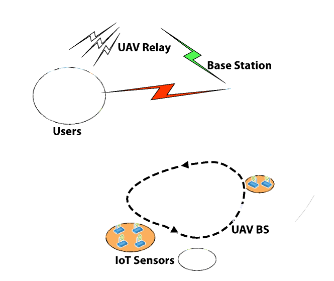
The exploitation of drones, aka UAVs, within the future 6G wireless cellular communication networks has recently gained significant attention. Several scenarios have been articulated in the literature which we can be categorize as Drone-as-a-Terminal (DaaT), Drone-as-a-Relay (DaaR), Drone-as-a-Base station (DaaB), and Drone-as-a-Sensor (DaaS) scenarios, respectively. In the DaaT scenario, applications range from delivery to monitoring and surveillance, and wireless networks play a vital role to carry UAV control (possibly video-based) and command data. In contrast, the DaaR and DaaB frameworks view the UAV as a piece of the radio access network (RAN) infrastructure, as shown in Fig. 1. The UAV acts as a flying base station (BS) which can, for example, harvest data sent from ground nodes. The UAV can also be a flying real-time relay to extend coverage from a ground-based fixed BS. A promising feature of both DaaB and DaaR scenarios is to allow a flexible deployment of radio resources when and where they are most needed. Use cases range from disaster recovery scenarios, servicing of temporary cultural/sporting events, road traffic assistance, hot-spots coverage, and Internet-of-Things (IoT) data harvesting (smart city, agriculture, …) [1]. In DaaS applications, the UAV acts as a flying sensor collecting (radio) data for radio frequency (RF) sensing and localization purposes, which are important and novel use cases for 6G.
While research challenges dealing with radio-aided UAVs and UAV-aided radio networks are plenty, the problem of how UAVs can best (self-) navigate the radio environment to render the best possible communication or sensing services remains perhaps the most critical and fascinating issue [1].
In order to offer much needed performance guarantees, the trajectory design algorithms must be adaptive to context parameters, such as ground radio node locations, the traffic distribution, the quality of service (QoS) or sensing requirements, and the propagation conditions shaped by the radio obstacles. Ideally, the algorithm operates in an autonomous fashion, either on-board the drone or in a ground-based computing unit that is connected to the drone. From an algorithmic perspective, it is important to distinguish between the (i) static placement problem from (ii) path or trajectory planning. Static placement involves finding a single good 3D location for the UAV, from where to provide connectivity to not-too distant ground nodes or sense the environment. While the solution may be updated when large-scale system parameters vary, such as traffic or ground user location distributions, the UAV location is otherwise stable and can benefit from energy-saving mechanisms, such as the ability to exploit nearby resting spots [2]. In some scenarios, however, there is interest in flying along an optimal path. For DaaB scenarios, a pattern that brings the UAV closer in turn to each ground node will improve the average throughput over a static deployment [3] or reduce energy expenditure at the nodes in an IoT setting [4]. Path optimization may also take into account specific kinematic energy consumption models, obstacle avoidance, as well as realistic robot dynamics, leading to a potentially complex mixed communication-robotics optimization framework [1].
Regardless of the static or dynamic nature of the placement strategy, the algorithms usually operate on the basis of an array of information which may include ground node GPS location information, per-node data traffic requirements and, importantly, terrain-dependent propagation data allowing the reliable prediction of radio signal strengths. While such data may be collected via the network beforehand allowing placement to be optimized before the actual UAV flight, part or all of the information may also have to be discovered or learned by the UAV while in flight to its destination, implying some degree of online optimization. The choice between the offline and online cases gives rise to an interesting trade-off between flight efficiency and adaptability vis-à-vis a priori unknown deployment settings.
In the DaaB and DaaR settings, the premium offered over fixed cellular deployment essentially lies in the ability to bring the RAN closer to the user so as to increase the radio channel quality. In the DaaS case, the designed trajectory aims at optimally enriching the set of measurements collected along the path in order to accelerate sensing performance.
In all these cases, the influence of channel models in the placement solution is critical. The assumption of Line-of-sight (LoS) channels or the use of simple statistical blocking models (i.e. modeling the LoS probability) has proved an excellent way to derive early insights into the problem [5, 1]. Unfortunately, the probabilistic nature of such approaches limits our ability to guarantee performance in an actual UAV deployment. For example, a statistically optimized placement of a flying BS might suggest a location which one eventually discovers to be severely affected by local blockage (e.g. unforeseen presence of a tall building) forcing the drone to recompute a sub-optimal path.
As an alternative to probabilistic channel models, trajectory design can instead exploit channel prediction based on local terrain features. To this end, the UAV can map out its environment or exploit readily available maps in order to navigate through the radio environment with enhanced reliability. As such, radio maps or 3D physical maps play an essential role in optimal UAV-based connectivity and sensing. The problem of estimating such maps from data collected at the UAV and suitable channel models is looked at in the next sections, followed by methods for placing the UAV optimally on the basis of the maps. The problem of optimally placing the UAV for communication or sensing purposes based on map data unfortunately comes with its own challenges. One of them is referred to as the ”rich data dilemma”: On the one hand, radio or 3D maps are rich in useful contextual information, revealing the position of each radio obstacle. On the other, radio blockage is often irregular and causes a lack of structure in the map, breaking differentiability in the placement optimization problem. As shown in this paper, a possible solution to this issue can be found in the concept of map compression which attempts to retain the ”local knowledge” feature of maps while lending the differentiability aspect to the placement problem, making it amenable to standard optimization. Finally, this paper discusses the optimization of the flight path toward optimal sensing through robotics-inspired active learning principles. Section VI briefly presents practical prototype realizations.
II UAV-to-ground segmented channel models
Air-to-ground channel modeling plays an essential role in our problem. The quality of channel models lies in their ability to correctly predict power attenuation as a function of distance, frequency, as well as to characterize seemingly random blockage. While some models encompass multi-path fading, the placement optimization time scale is usually much longer than the fast fading coherence time, hence fast fading can be averaged out in a first approximation, leaving the design with the task of modelling the path loss or received signal strength indicator (RSSI). In contrast to terrestrial radio pathloss models, air-to-ground channels between low altitude flying radios and ground users are known to exhibit a segmented nature [5] that depends on the relative locations of UAV and user. In such models the path loss vs. distance follows the classical exponential decay rule where the exponent is selected from a discrete set of values and where the so-called segment value reflects the degree of link’s obstruction and its strong dependence on local terrain. As an example, we can differentiate the LoS and non-LoS (NLoS) nature of air-to-ground links by using a segmented model with , and representing the pathloss exponent in LoS and NLoS links, respectively. For a greater reality match, one may increase the number of segments to account for extra degrees of obstruction severity such as concrete building vs. wood-walled structure vs. foliage etc. Of course, more segment values means added complexity as well as a greater noise sensitivity when doing model classification.
II-A Map-aided vs. probabilistic attenuation models
The segmented pathloss model is highly dependent on the relative UAV-user locations and the local terrain. In map-aided approaches, the segment value is directly predicted from a 3D terrain map. For example, if the straight line connecting UAV and user location is obstructed by a blockage or building, we can infer that the radio link is of NLoS nature. In the absence of maps, probabilistic segmented models are used, whereby the segment value is simply governed by a likelihood parameter. In the popular two-segment model with LoS and NLoS segments, the LoS probability is used to obtain this likelihood. The LoS probability is a logistic type of function applied on where is the elevation angle between the -th user and the UAV. The intuition is that if the elevation is close to 90 degrees, the probability of LoS will approach 1, while if the elevation is small, a high probability of blockage is expected. Such probabilistic path loss models are global by nature in the sense that the model parameters are trained once and are the same across all ground nodes [5]. While this approach can give useful insights into the role played by certain system design parameters, it often falls short in real-life robotic placement problems because of the lack of performance guarantees. Instead, for an actual implementation, it is essential to exploit local information relevant to the terrain surrounding the ground nodes and the robot. There are several ways to infer such map-based information in practice, be it from 3D terrain data or radio measurements from the scene of interest as we review next.
III Learning Maps for Flying Radios
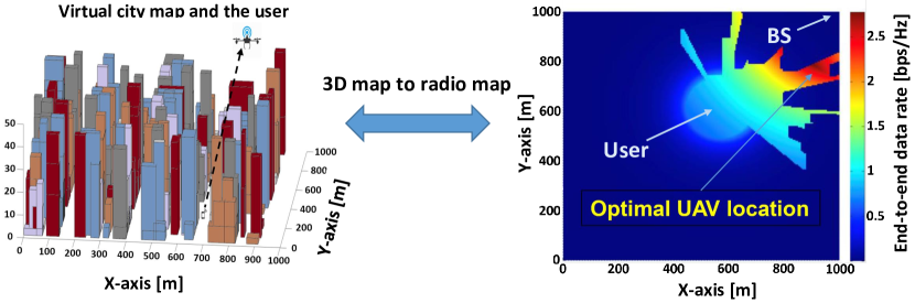
Various kinds of maps can be used to predict the channel quality between a UAV and a ground user. These include 3D terrain or building maps, radio (or RSSI) maps, and (system-level) throughput maps. Radio and 3D maps are strongly inter-related via the existence of a reliable path-loss model, as illustrated in Fig. 2. This gives rise to powerful joint radio and 3D map estimation opportunities, which are later mentioned. Generally, radio and throughput maps are 5D objects as the RSSI or throughput is specified for each pair of 3D UAV location and 2D ground user location111In this paper we mostly consider outdoor service. If indoor users are accounted for, a 3D model for user locations ensues.. The throughput map may include the effect of finite backhaul between the fixed infrastructure and a UAV acting as a relay. A simplifying relay model is based on the decode-and-forward framework whereby the capacity is governed by the minimum capacity between the BS-to-UAV link and UAV-to-user link throughput, respectively. Note that the BS-to-UAV link rate is more easily predictable from a distance-based path loss model as the UAV is often assumed to maintain LoS with the BS. This leaves the system designer with the sole (yet challenging) task of predicting the actual link strength between the UAV and the ground user. Once maps are obtained, it becomes possible to place the UAV at a throughput-maximizing location or path.
The advantage of map-based placement over a probabilistic approach is well illustrated in Fig. 2 which shows the link throughput for a UAV-relay enabled communication link between a fixed BS and one ground user. While a probabilistic approach would always place the UAV somewhere on the axis between the BS and the ground user so as to minimize path travel length, the throughput map predicts an optimal UAV location well off the BS-user axis. Generally, map-based placement determines the best trade-off between minimizing distances (i.e., staying close to the BS-user axis) and exploring LoS opportunities at other locations to boost user signal power.
III-A Learning radio maps from sparse UAV-borne RSSI measurements
Radio or 3D maps are not always readily available and, as flying time is costly, often need to be reconstructed from a limited set of radio measurements. Let us consider the problem of predicting the air-to-ground link quality at arbitrary UAV locations for one fixed ground user location. The problem of radio map reconstruction in the fixed cellular context is not new. In fact recent advances using deep learning have been reported such as in [6]. In our context, it is assumed that a finite number of RSSI measurements have been collected beforehand by the UAV for training. Typically, the training data points offer a sparse representation of the radio map, which must then be reconstructed at all locations where measurements are missing. Note that this can be done using standard or adapted machine learning techniques. Generally speaking, the map reconstruction may be direct or model-based [7]. For a direct reconstruction, one relies on the hidden correlation structure between RSSI levels at neighboring training data points and a new candidate UAV location in order to generate an estimate of the RSSI at the new location. Averaging of RSSI levels has been considered in [8] using kernel regression methods. Alternatively, a model-based approach can be used which exploits radio expert knowledge in the form of the segmented channel models shown earlier. We need to first estimate the unknown model parameters from the training data. Unfortunately, it is not known a priori to which segment each of the training data points actually belongs to. To circumvent the absence of segment labels in the data, a joint classification and parameter estimation approach is proposed. The basis of this approach is two-stage iterative process where classification of the data points is first carried out by way of a clustering algorithm on the basis of pre-estimated model parameters. Then the propagation parameters for each segment can be re-estimated using maximum-likelihood estimation or least-squares estimation on each corresponding subset of the data [7].
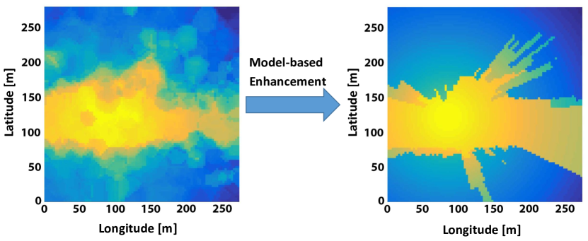
In Fig. 3, the performance of model-based radio map reconstruction is illustrated and compared with a direct reconstruction approach in the RSSI domain using the kernel trick [8] for a selected area at center Washington DC [7]. The UAV moves at a fixed height 50 meters above ground to visit 400 randomly selected training locations to measure the link quality to 100 random ground user locations. The model-based approach can reconstruct the crisp shapes of the propagation segments with accurate prediction on the channel gain.
III-B Radio maps vs. 3D terrain maps
Note that the above radio map reconstruction is carried out for one particular fixed ground user location. However, in the presence of ground users, a separate radio map per user must be estimated in principle such that an overall system-level throughput map can be drawn222 Multi-user throughput may be defined in a number of ways, including sum throughput, fair throughput, worst case throughput etc. In all such cases we assume orthogonal multiple-access however.. Note that the throughput map could in principle be reconstructed directly from sparse measurements done directly in the throughput domain, hence bypassing the radio map altogether. However this approach does not leverage expert knowledge related to channel models. On the other hand, it is desirable to exploit the inherent correlation existing between radio conditions for ground users that are close to each other. A powerful way to exploit blockage correlation across users is to introduce the 3D terrain map as auxiliary information. The use of 3D terrain maps can be explicit or implicit. If a 3D city map is available, link strengths are directly predicted from it using ray tracing followed by classification into one of the model segments.
Joint radio and 3D map reconstruction
In some cases, the 3D terrain map may not be available. In fact obtaining a 3D map of surrounding may be the actual goal in mind (e.g. sensing). In this case, it is still possible to reverse engineer the radio map back to the 3D terrain map domain. In practice, this is again done using the UAV’s RSSI measurement data set. While jointly estimating the model parameters, such RSSI levels are classified to one of two segment values (i.e. LoS or NLoS). In turn, a UAV-user link which is classified as LoS reveals that any building located between the two must be lower than the UAV-user axis, yielding a set of inequality constraints. A picture of the 3D building map emerges when aggregating these equations through a large enough number of RSSI measurements from scattered users in the city. It is then possible to exploit the common underlying structure between the radio map and the 3D terrain map. This is done by feeding the building height estimates obtained above, back into the RSSI prediction model so as to have a more complete radio map estimate. This procedure can be iterated until no more improvement is achieved. Finally another approach to enhance map reconstruction consists in complementing radio data with additional vision sensor data (camera or lidar) followed by a suitable fusion algorithm.
IV Map-based path planning of flying access points
In the above section, methods for acquiring useful map information on the basis of measurements carried out by radio-enabled UAVs were surveyed. We now turn our attention to the design of map-aided optimal paths for UAVs in the DaaR and DaaB contexts.
IV-A Placement of UAV based on nested propagation segments
Let’s assume a scenario in which ground users performing special tasks in an area where terrestrial connectivity is limited or degraded, e.g. military patrolling in remote areas, site or plant inspection by humans or rovers after a natural disaster etc. Such scenarios can benefit from the deployment of a user-dedicated UAV-mounted relay. The challenge is for the drone to self-position at a location allowing to maximize the throughput of the end-to-end relay channel. Since the link between the UAV and BS tower is likely to be relatively clear of obstacles (assuming high enough BS antenna), the intuition behind optimal UAV position lies in striking a balance between keeping path travel distances low (both for the backward link to the BS as well for the forward link to the users) and maintaining a good link quality to the users by discovering LoS opportunities. Although the optimal position can be, in theory, computed offline using a global search over the radio map, it is desirable to have a method which only requires local exploration of the map. Such benefit is made possible by exploiting an interesting nested propagation property.
The property reflects the notion of LoS irreversibility. Assume a UAV flies at constant height, initially far off and moving towards a ground node. Also assume the UAV is initially located in the NLoS region of this node, then it will hit LoS region once the UAV gets close enough to the ground node. LoS irreversibility predicts that LoS will be maintained without interruption until the UAV reaches the spot right above the node’s location. Intriguingly, an implicit condition for this is that the buildings and other (large) obstacles on the ground have a convex shape, which fortunately is often the case. For a more general segmentation (), this property extends by arguing that the UAV-user channel tends to become less obstructed as the UAV moves towards the ground user. For a fixed given ground node location, denoting by the region formed by UAV locations for which , we have that is nested inside (e.g. the LoS region is nested inside the NLoS region). Note that the nested propagation regions property conveys some useful structure to radio maps and it can be shown that the optimal UAV position can only be either the BS-user axis or one segment’s boundary. As a result, it is possible to derive globally convergent algorithms with linear search complexity in terms of the BS-user distance [9].
IV-B Intelligent IoT data harvesting
When the UAV addresses the connectivity of multiple ground nodes, it can be shown [3] that the optimal placement involves designing a path allowing the UAV to cycle through points located above, and in the vicinity of these ground nodes, as opposed to having the UAV hover above a static location. To what extent that path takes the UAV near the nodes depends on the limited on-board battery budget. The problem of designing an optimal communication path can be formulated as an extension of UAV static placement where the UAV location is replaced by a vector of time-discretized locations satisfying extra dynamical constraints (bounded velocity, acceleration and deceleration); the throughput reflects a summation over the rates offered to the multiple ground nodes. With the use of probabilistic segmented channel models, the optimal path design is amenable to classical optimization tools thanks to the differentiability of the RSSI with respect to UAV location [1]. The disadvantage of this approach is that local terrain features are ignored and the obtained path cannot offer performance guarantees on communication quality.
IV-C Map compression
When the RSSI at a given drone location is drawn from a 3D or radio map, we obtain rich local information enabling accurate throughput predictions at the UAV. Unfortunately, the irregular shapes of the LoS regions in the many user case renders the throughput function non-differentiable as a function of the UAV location. A key to solving this problem resides in the idea of map smoothing or compression [4]. The goal is to preserve essential node-location dependent channel behavior while smoothing out other map details. In practice, this is done by converting map data into a reliable node location dependent LoS probability model which is now modeled by where denotes the elevation angle for ground node and the LoS probability is now made dependent on the location of ground node by using node-dependent logistic regression parameters. Such parameters can be learned (e.g. [4]) from a training data set formed by a set of tentative UAV locations around the -th ground node along with the true LoS status obtained from the 3D map. Interestingly, the extended model above can be seen as localized extension of the classical probability model. The key advantage in using the local probability model over the global one is that it discriminates between the ground nodes in terms of LoS opportunities they allow, while going around the non differentiability issues created by raw map data.
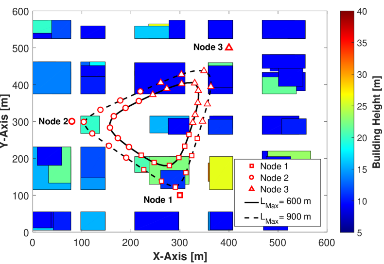
An example of a path obtained under the map compression approach for an IoT setting with 3 nodes is shown in Fig. 4. The optimal path design exploiting compressed map information allows the UAV to exploit LoS opportunities when possible, for some of the ground nodes, while designing a path under classical probabilistic channel models, tends to treat all ground nodes in a similar way. As a result of using the map compression technique, the UAV can decide to stay at a distance from node 3 which is located in a relatively open area while cycling closer to other nodes which are shadowed away by taller buildings that can bring a considerable gain in the amount of data collected from the nodes [4].
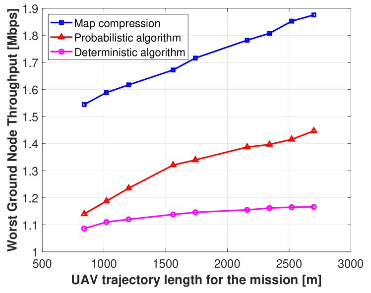
Fig. 5 shows the advantage of using the map compression method over different algorithms for UAV trajectory design in an IoT scenario where a DaaB collects data from 6 ground sensors. In the deterministic algorithm, an optimal trajectory is generated by considering a single deterministic LoS channel model for the links between the UAV and ground sensors. In the probabilistic algorithm, a probabilistic segmented channel model, which was introduced in section II-A, is used [4].
V Robot-aided RF sensing based on active learning
So far we have seen the use cases of UAV acting as a flying RAN device aiming to improve the wireless connectivity services towards ground nodes. In the context of 6G research where there is a growing convergence between communication and sensing systems [10], we can consider the DaaS scenario where the UAV acts as a flying RF sensor that can assist with sensing and localization services. Contrary to static or uncontrolled mobile devices in the network, we can optimize the UAV trajectories to improve the sensing and localization performance. Specifically, UAV path planning problems that constitute a good trajectory to collect the most informative measurements, among all feasible paths, satisfying a duration or energy budget constraint can be formulated. In machine learning and robotics, this problem is sometimes referred to as active learning or optimal experiment design [11].
Interestingly, the map can one more time help to predict a UAV trajectory allowing us to collect maximally informative measurements. For instance, the availability of the 3D map can let us determine where and when the UAV can maintain LoS connections to the users for collecting the measurements which tend to be more suitable for precise sensing (i.e. LoS measurements are subject to less shadowing noise than NLoS measurements). It is shown in [12] that by exploiting the 3D map an improvement of about over the other approaches in the user localization accuracy can be obtained.
VI Prototypes
The problem of autonomous placement of micro-UAVs as flying radios (LTE relays or BSs) has been the subject of relatively few practical deployments and prototypes to date. In fact, much prior work examining the design of UAV-based RANs is based on the simplifying idea that the UAV serves as a mechanical flying device on which a BS is mounted, hence communication and navigation functionalities are mostly kept decoupled. Hence, the potential associated with optimized 3D placement with UAV BSs in theoretical works cannot be fully demonstrated with such prototypes in real-world scenarios.
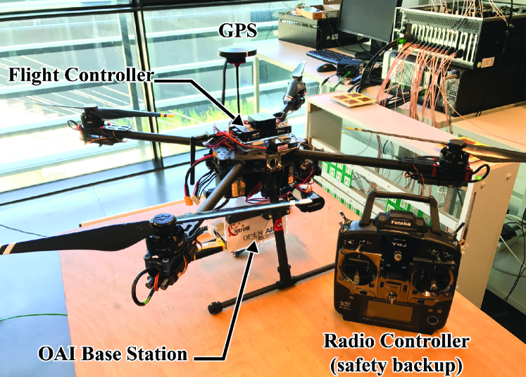
In [13], the Rebot (Relay Robot) concept was presented. The Rebot functions both as an outdoor LTE relay between ground users and a fixed BS, as well as a fully customized autonomous robot capable of positioning itself at a throughput maximizing location. The Rebot’s communication layer embedded on the UAV is based on the OpenAirInterface (OAI), which is an open-source reference implementation of 3GPP standards running onboard the UAV using commodity Linux computing equipment. In [13], a video recording of the experiment on the EURECOM campus is also captured, illustrating the throughput advantage and the machine learning-driven self-placement and tracking capabilities of the Rebot. The UAV continuously collects and processes radio measurements over the flight path to update the estimate for the optimal placement solution. Different parts of the UAV are shown in Fig. 6.
VII Perspectives
The deployment of UAV-aided wireless networks offers a host of mixed robotic-communications analysis problems [1]. Real-time placement algorithms remains a central issue for which the use of machine learning-driven map-aided methods seem promising. Interestingly, the useful interactions between 3D mapping and UAV path planning have also been recently investigated in scenarios beyond the sole UAV-aided communication use cases. For instance the role of maps was highlighted in the context of UAV positioning for optimal wireless power transfer [14]. In the DaaT scenario, a central issue is the design of safe UAV paths that allow the robot to reach a prescribed destination while satisfying connectivity (from network) constraints all along the way. The use of radio maps was shown to be highly beneficial also in that context [15] as they enable more accurate connectivity predictions than probabilistic channel models. In such DaaT scenario as well, maps create an information richness dilemma which can be mitigated using the compression method surveyed in Sec. IV-C.
Moreover, the ideas and tools discussed in the above sections can be extended to multi-UAV scenarios where there are several UAVs (i.e. a swarm of UAVs) cooperating to provide better coverage and services to users. However, when it comes to the multiple UAVs, we still need to face the same problem as in the single UAV case, because when a UAV in the swarm communicates with a ground node, the communication link may probably be blocked by obstacles. Therefore, the exploitation of the map and ideas proposed in this paper can still be beneficial for the multi-UAV case to guarantee the link quality between UAVs and ground users.
VIII Acknowledgment
Part of the work by David Gesbert, Omid Esrafilian, and Rajeev Gangula was funded via the HUAWEI France supported Chair on Future Wireless Networks at EURECOM. The part done by Junting Chen was supported by the National Key R&D Program of China with grant No. 2018YFB1800800, by National Science Foundation of China No. 92067202 and No. 62171398, by the Shenzhen Science and Technology Program under Grant No. JCYJ20210324134612033, and by the Guangdong Provincial Key Laboratory of Future Networks of Intelligence. The part done by Urbashi Mitra was supported by ONR N00014-15-1-2550, NSF CCF-1817200, ARO W911NF1910269, Cisco Foundation 1980393, DOE DE-SC0021417, Swedish Research Council 2018-04359, and NSF CCF-2008927.
References
- [1] Q. Wu, J. Xu, Y. Zeng, D. W. K. Ng, N. Al-Dhahir, R. Schober, and A. L. Swindlehurst, “A comprehensive overview on 5G-and-beyond networks with UAVs: From communications to sensing and intelligence,” IEEE Journal on Selected Areas in Communications, 2021.
- [2] R. Gangula, D. Gesbert, D. F. Kuelzer, and J. M. Franceschi, “A landing spot approach for enhancing the performance of UAV-aided wireless networks,” in IEEE ICC Workshop, 2018.
- [3] Y. Zeng and R. Zhang, “Energy-efficient UAV communication with trajectory optimization,” IEEE Trans. Wireless Commun., vol. 16, no. 6, pp. 3747–3760, 2017.
- [4] O. Esrafilian, R. Gangula, and D. Gesbert, “Learning to Communicate in UAV-Aided Wireless Networks: Map-Based Approaches,” IEEE Internet of Things Journal, vol. 6, no. 2, pp. 1791–1802, 2019.
- [5] A. Hourani, K. Sithamparanathan, and S. Lardner, “Optimal LAP altitude for maximum coverage,” IEEE Commun. Lett., no. 99, pp. 1–4, 2014.
- [6] R. Levie, Ç. Yapar, G. Kutyniok, and G. Caire, “Radiounet: Fast radio map estimation with convolutional neural networks,” IEEE Transactions on Wireless Communications, 2021.
- [7] J. Chen, O. Esrafilian, D. Gesbert, and U. Mitra, “Efficient algorithms for air-to-ground channel reconstruction in UAV-aided communications,” in Proc. IEEE Globecom Wi-UAV workshop, Dec. 2017.
- [8] D. Romero, S.-J. Kim, G. B. Giannakis, and R. Lopez-Valcarce, “Learning power spectrum maps from quantized power measurements,” IEEE Trans. Signal Process., vol. 65, no. 10, pp. 2547–2560, 2017.
- [9] J. Chen and D. Gesbert, “Efficient local map search algorithms for the placement of flying relays,” IEEE Trans. Wireless Commun., vol. 15, no. 2, Feb. 2020.
- [10] A. Bourdoux, A. N. Barreto, B. van Liempd, C. de Lima, D. Dardari, D. Belot, E.-S. Lohan, G. Seco-Granados, H. Sarieddeen, H. Wymeersch et al., “6G white paper on localization and sensing,” arXiv preprint arXiv:2006.01779, 2020.
- [11] A. T. Taylor, T. A. Berrueta, and T. D. Murphey, “Active learning in robotics: A review of control principles,” Mechatronics, vol. 77, p. 102576, 2021.
- [12] O. Esrafilian, R. Gangula, and D. Gesbert, “3D Map-based Trajectory Design in UAV-aided Wireless Localization Systems,” IEEE Internet of Things Journal, 2020.
- [13] R. Gangula, O. Esrafilian, D. Gesbert, C. Roux, F. Kaltenberger, and R. Knopp, “Flying rebots: First results on an autonomous UAV-based LTE relay using open airinterface,” in IEEE SPAWC, 2018.
- [14] J. X. X. Mo, Y. Huang, “Radio-map-based robust positioning optimization for UAV-enabled wireless power transfer,” IEEE Wireless Communications Letters, 2019.
- [15] S. Zhang and R. Zhang, “Radio Map-Based 3D Path Planning for Cellular-Connected UAV,” IEEE Transactions on Wireless Communications, vol. 20, no. 3, pp. 1975–1989, 2020.
| David Gesbert [Fellow, IEEE] is Director of EURECOM, France. He received his Ph.D. from TelecomParis, in 1997. Prior to EURECOM, he was with ISL, Stanford University, was a founding engineer of Iospan Wireless Inc., a Stanford spin-off pioneering MIMO-OFDM, and with the University of Oslo. He published about 350 articles and 25 patents, 7 of them winning IEEE Best paper awards, and was named a Highly Cited Researcher in computer science. He is a Board Member of the OpenAirInterface Software Alliance. He was an awardee of the ERC Advanced Grant and the Grand Prix in Research from IMT and the French Academy of Sciences. |
| Omid Esrafilian [Member, IEEE] received his Ph.D. degree from Sorbonne University and EURECOM, France, in 2020. He is currently working at EURECOM as a research engineer building prototypes for autonomous aerial cellular relay drones capable of providing flexible and enhanced (LTE, 5G) connectivity to mobile users. He was the recipient of several awards in the national and international robotics competitions as well as the award for ”Fundamental research project of the year”, 2019, by the French SCS Research and Industry Cluster. His main research interests include unmanned aerial vehicle communication systems, machine learning, and robotics. |
| Junting Chen [Member, IEEE] received the B.Sc. degree in electronic engineering from Nanjing University, Nanjing, China, in 2009, and the Ph.D. degree in electronic and computer engineering from The Hong Kong University of Science and Technology (HKUST), Hong Kong, SAR, China, in 2015. He is currently an Assistant Professor with the School of Science and Engineering and the Future Network of Intelligence Institute (FNii), The Chinese University of Hong Kong, Shenzhen (CUHK-Shenzhen), China. He works on radio map learning and applications, UAV assisted communications, and, more generally, machine learning and optimization for wireless communications and localization. |
| Rajeev Gangula [Member, IEEE] obtained his Ph.D. degrees from Telecom ParisTech (Eurecom), France, in 2015. He is currently working at Eurecom as a research engineer building prototypes for autonomous aerial cellular relay drones capable of providing flexible and enhanced (LTE, 5G) connectivity to mobile users. His research interests lie in the areas of optimization, communication theory and development of unmanned aerial vehicle communication system. |
| Urbashi Mitra [Fellow, IEEE] is currently the Gordon S. Marshall Professor in Engineering at the University of Southern California. She is the recipient of: the 2021 USC Viterbi Senior Research Award, 2017 IEEE Women in Communications Engineering Technical Achievement Award, a 2015 UK Royal Academy of Engineering Distinguished Visiting Professorship, a 2015 US Fulbright Scholar Award, a 2015-2016 UK Leverhulme Trust Visiting Professorship, IEEE Communications Society Distinguished Lecturer, 2012 Globecom Signal Processing for Communications Symposium Best Paper Award, 2012 US National Academy of Engineering Lillian Gilbreth Lectureship, the 2009 DCOSS Applications & Systems Best Paper Award, 2001 Okawa Foundation Award, 2000 Ohio State University’s College of Engineering Lumley Award for Research, and a 1996 National Science Foundation CAREER Award. |