\system: Augmented Reality Supported Collaboration for UAV Driven Emergency Response Systems
Abstract.
Emergency response events are fast-paced, noisy, and they require teamwork to accomplish the mission. Furthermore, the increasing deployment of Unmanned Aerial Vehicles (UAVs) alongside emergency responders, demands a new form of partnership between humans and UAVs. Traditional radio-based information exchange between humans during an emergency response suffers from a lack of visualization and often results in miscommunication. This paper presents a novel collaboration platform: RescueAR, which utilizes the paradigm of Location-based Augmented Reality to geotag, share, and visualize information. \systemaims to support the two-way communication between humans and UAVs, facilitate collaboration across diverse responders, and visualize scene information relevant to the rescue team’s role. According to our feasibility study, user study, followed by a focus group session with police officers, \systemcan support rescue teams in developing the spatial cognition of the scene, facilitate the exchange of geolocation information, and complement existing communication tools during the UAV-supported emergency response.
Description
1. Introduction
Technological advancements have enabled Unmanned Aerial vehicles (UAVs) to evolve from manual to semi-autonomous to near fully autonomous operations (Floreano and Wood, 2015). As a result, they have gained in popularity as surveillance, delivery, photography, and emergency rescue tools, with state of the art emergency response teams exploring the use of smart UAVs for public safety operations such as search and rescue (Khan et al., 2014; Scherer et al., 2015), firefighting (Jayapandian, 2019; Aydin et al., 2019), surveillance (Basso et al., 2018; Sărăcin et al., 2017), and disaster relief (Nguyen et al., 2019). While technological advances allow UAVs to operate independently, human supervision with timely interventions are still necessary to ensure their ethical and safe operations. Therefore, both humans and smart UAVs are required to work together as a Human-Agent Team (HAT) (Klien et al., 2004) during emergency response (Bellamy et al., 2017; Cleland-Huang and Agrawal, 2020; Agrawal et al., 2020b). As an example of this partnership, law enforcement officers in California recently utilized smart UAVs to help them catch a shooter running through the streets 111https://www.nytimes.com/2020/12/05/technology/police-drones.html. Officers at their headquarters continuously monitored the live video feed, and relayed details to the police officers on the scene as the smart drone autonomously tracked the shooter through crowded parking lots, strip malls, and narrow streets. While the drone provided a bird’s eye view of the evolving scene, effective communication between the off-site officers and the on-site team ultimately played a crucial role in catching the shooter. Similarly, in 2019 French firefighters used two UAVs equipped with thermal cameras to assess the fire scene and distribute fire hoses effectively to fight the fire at Notre-Dame cathedral in Paris 222https://www.theverge.com/2019/4/16/18410723/notre-dame-fire-dji-drones-tracking-stopped-thermal-cameras. This massive emergency response operation involved more than 400 people, including firefighters, government officials, police, and municipal workers, and demonstrated the use of the UAV’s onboard cameras, sensors, and computers to augment information collected by on-scene first responders and to provide timely insights to the mission commander and other team members throughout the mission. It also highlights the need for effective communication amongst humans, smart UAVs, and between humans and UAVs during emergency situations (Cleland-Huang and Agrawal, 2020).
To identify communication barriers, Manoj et al. (Manoj and Baker, 2007) observed the first responders’ as they engaged in exercises, drills, and workshops. Apart from the technical challenges associated with providing first responders with a robust communication network during an emergency response, Manoj et al. (Manoj and Baker, 2007) also identified communication challenges at the social as well as organizational level.
The social communication challenge is to ensure a coherent interpretation of the situation among emergency responders. Information communicated over the radio suffers from noise in signals, lacks visualization, and is difficult to persist for later analysis. In a separate study (Agrawal et al., 2020a), first responders reported that sharing information over the radio in an already noisy environment can lead to an inaccurate perception of a situation. Organizational communication challenges also arise due to information gaps between primary decision-makers such as on-site first responders, remote emergency operations centers (EOC), and local governments when planning emergency responses. Therefore, the social and organizational challenges of communication necessitate improving the way emergency response teams consume and share information (Andreassen et al., 2020; Bergstrand and Landgren, 2009; Guntha et al., 2020) during emergency response. This paper aims to address the social and organizational issues of communication during an emergency by supporting rescue team members in geotagging different pieces of information on the scene and visualizing it upon demand. Geo-locatable information can be shared and visualized in different formats such as on 2D maps for mission commanders (Domova et al., 2020), overlays on video streams for remote team members, and even by displaying virtual objects using augmented reality head-mounted displays for the on-scene first responders(Roldán et al., 2019; Roldán et al., 2017). UAVs in emergency response also utilize geolocated information to make autonomous decisions during missions. For example, during a river search and rescue mission, a UAV could autonomously deliver a flotation device based on the geolocation of the potential victim (Agrawal et al., 2020b).
In this work, we utilize the paradigms of Location-based Augmented Reality to design \systemwith the intent of helping mission commanders, first responders, and rescue teams to communicate scene information and retain situational awareness as an event unfolds. The design of \systemcomprises three different interfaces: FirstResponse-AR, Flying-AR, and Mission-Control , all of which empower responders to share and visualize information according to the diverse needs of their specific team roles. \systemautomatically computes the geolocation of objects of interest in the aerial video stream captured by UAVs in real-time. These objects can be detected using onboard image recognition models or tagged in the video stream by emergency responders. \systemfirst computes the geolocations of the physical objects in the environment and then places virtual objects at these geolocations in the AR world space. \systemalso persists the geolocations of objects on a cloud server to make them visually available upon demand across all three UIs. \systemrepresents a pragmatic approach for alleviating the social and organizational challenges of communication during an emergency response.
The main contributions of this paper are: (i) the design and implementation of the \systemcomponent: Flying-AR , as an interface for remote rescue team members to create, share, and visualize AR content during the UAV-driven emergency response mission, (ii) a second interface for On-Scene Response teams: FirstResponse-AR , which builds upon the design of existing AR interface (Campos et al., 2019) and adapts them for use in a UAV-driven emergency response system, (iii) feedback from a focus group study that assesses the differences between verbal and visual modes of communicating a scene in a rapidly changing environment, and (iv) recommendations for the design of frameworks for the UAV-driven emergency response system emphasizing visual communication. We conducted multiple studies to learn the feasibility, usability, and end-users’ (police officers) perspective of our system. We found that \systemoffers a pragmatic approach to alleviate the social and organizational challenges of communication during emergency response. \systemmakes critical geolocation information more accessible, and the visualization of the points of interest (POIs) improves the spatial understanding of the scene among the rescue team members. Further, a team of police officers indicated that \systemwould complement the existing communication infrastructure (radios) of their emergency rescue teams.
The remainder of the paper is organized as follows. In Section 2, we provide background knowledge on human-UAV interaction and augmented-reality applications for collaboration. In Section 3, we describe RescueAR, including its architecture and implementation details. Section 4 explains the methodology we used to evaluate \systemand present the results from our experiments and a user study. In section 5, we describe police officers’ perspective on the design of \system. Section 6 summarizes the findings and provide opportunities to explore in future to design AR-Based tools for emergency response. Finally, In Section 7, we discuss the limitations of our work and conclude our discussion in Section 8.
2. Background and Related Work
2.1. UAV Driven Emergency Response
UAVs stream the bird’s eye view of emergency situations and can provide valuable information to the rescue team (Jones et al., 2016). Khan et al., (Khan and Neustaedter, 2019) interviewed firefighters and learned that communicating effectively with remote emergency rescue teams is critical in the design of a UAV driven emergency response system. Similarly, Lopez et al., (López et al., 2017) demonstrated that using live video footage of the incident from UAVs enables firefighters to devise strategies to mitigate damage ahead of time. Similarly, our work leverages real-time aerial video streams to distribute scene information. In particular, we focus on designing interfaces for demand-based visualization of the scene information to improve the situational understanding of various rescue teams.
Agrawal et al., (Cleland-Huang et al., 2020; Agrawal et al., 2020b; Agrawal et al., 2020a) conducted multiple participatory design sessions with firefighters to explore the role of smart UAVs’ assistance in emergency situations. They also provided guidance for designing interfaces for UAV-based emergency response systems, and emphasized the need to support multi-user collaboration between humans and smart UAVs (Cleland-Huang and Agrawal, 2020; Abraham et al., 2021). While this prior work has studied the importance of humans and multiple UAVs collaborating under various circumstances, the new work described in this paper presents a novel interaction technique based on annotating aerial video stream with POI information and visualizing it across role-specific interfaces, to improve human-UAV collaboration during emergency response scenarios.
2.2. Augmented Reality for Collaboration
Augmented Reality (AR) technology augments the humans’ perception of the real world by adding virtual elements to it. Location-based AR experiences (Paucher and Turk, 2010) rely on the location of the device to determine where and how to place a virtual object within the real world, whereas vision-based AR relies on known image markers (Kato and Billinghurst, 1999) or complex scene analysis algorithms to augment the real world with virtual objects (Gauglitz et al., 2014; Carozza et al., 2014). In contrast, Remote Augmented Reality (RAR) extends location or vision-based AR experiences by augmenting videos received from remote sources with 3D models and graphics in real-time. The usability of RAR has been explored widely for remote assistance applications in the manufacturing industry for connecting end-users to remote experts for product maintenance (Masoni et al., 2017) (Mourtzis et al., 2017b) (Mourtzis et al., 2017a) (Schneider et al., 2017), and in the healthcare industry for remote surgical guidance, and teleportation (Wang et al., 2017) (Mather et al., 2017) (Rojas-Muñoz et al., 2020). Similarly, Unal et al., (Unal et al., 2020) demonstrated the use of RAR for delivering a lively experience of cultural heritage to tourists. In contrast, we utilize RAR to share and communicate scene information to team members.
In the context of emergency response, researchers discovered AR’s suitability for communicating information within and among rescue teams during earthquakes (Leebmann, 2004), fire outbreaks (Wani et al., 2013), and medical emergency services (Schlosser et al., 2021). The THEMIS-AR (Nunes et al., 2018) is an AR mobile application designed to improve emergency responders’ scene perception by overlaying context-relevant information, such as distance, time, and position of POIs on their scene perception via a head-mounted display. Further, Campos et al., (Campos et al., 2019) extended THEMIS-AR to study AR user interfaces and provide guidelines for designing AR applications for emergency response. However, the scene information in THEMIS-AR is geo-referenced manually, and the AR application overlays that same information on the first-person views of onsite first-responders, such as the number of casualties, distance to the nearest hospital, or fire location. In contrast, this paper builds upon previous work for UAV based emergency response systems by 1) automatically computing the Geo-location of POIs from their image pixel coordinates in the aerial video frame, 2) allowing remote rescue teams to add, track and visualize POI data in real-time as overlays over videos streamed by UAVs via Flying-AR, and 3) allowing on-site first responders to visualize dynamically identified scene information by other rescue teams or UAVs in the first-person view via FirstResponse-AR. Further, \systemalso allows decision-makers to continuously visualize the points of interests on 2-D maps via its Mission-Control interface as the situation evolves.
3. Collaboration Framework: Rescue-AR
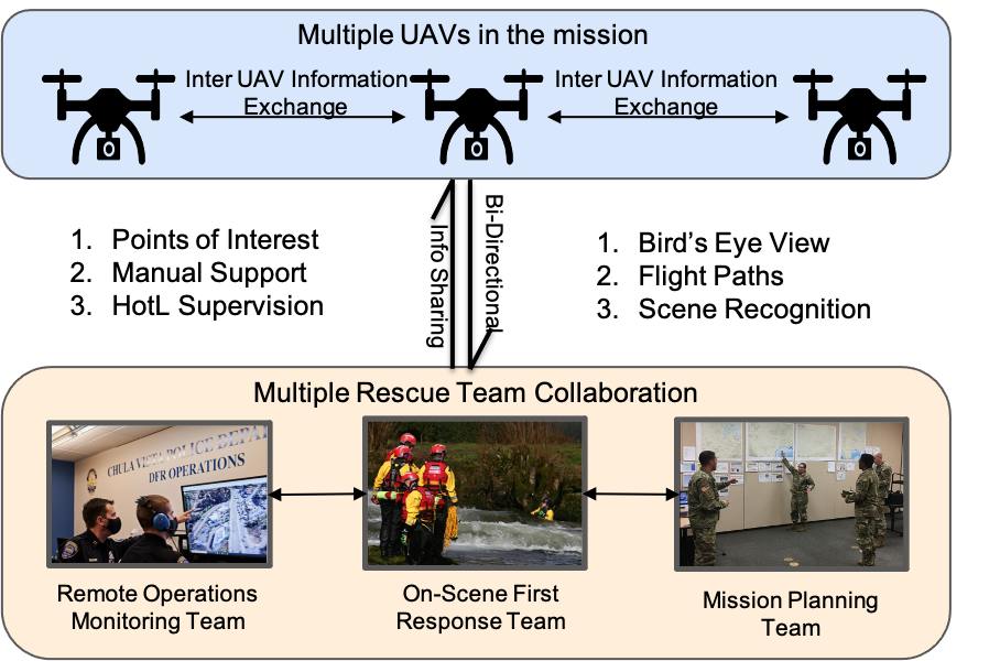
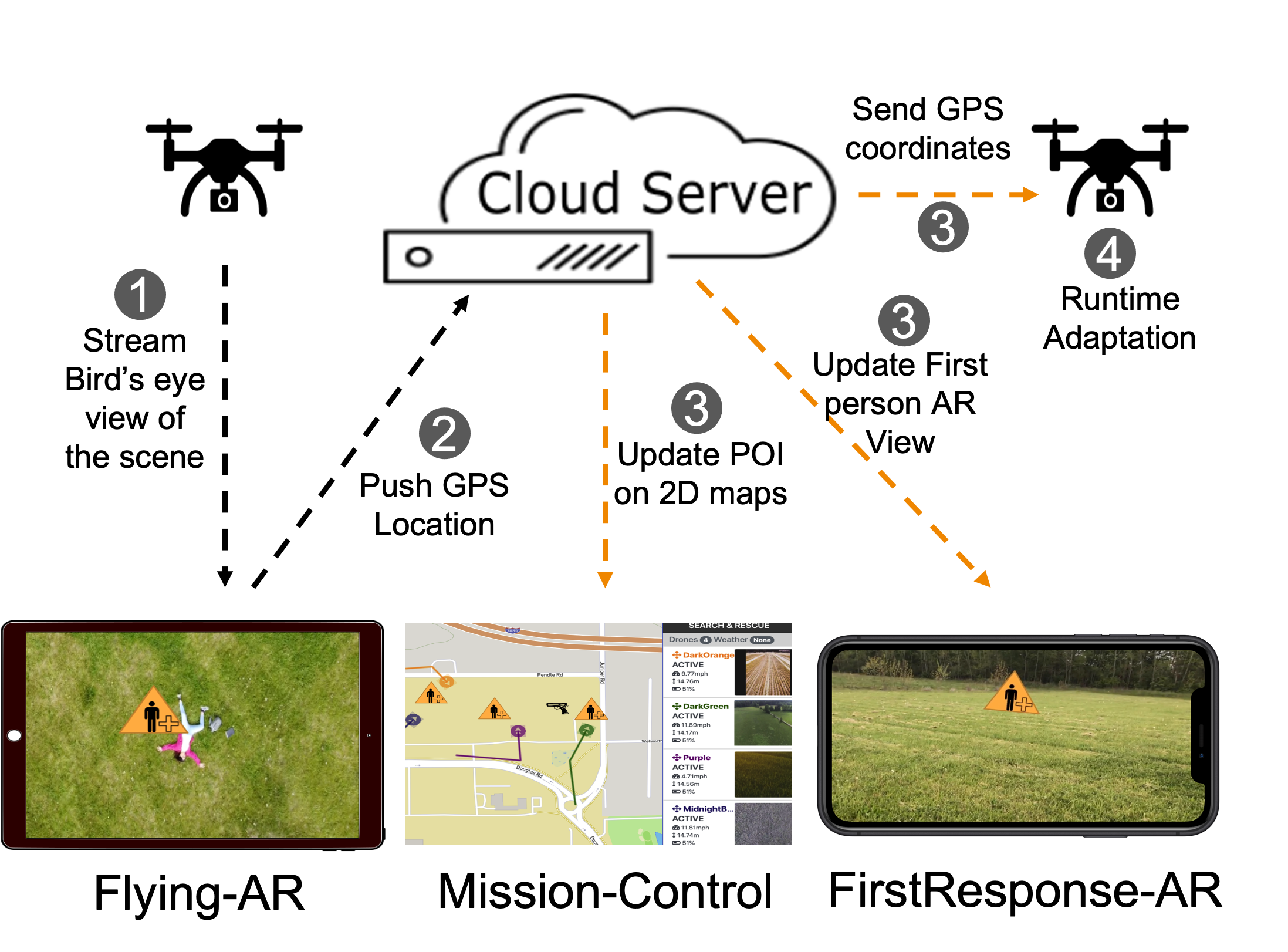
The purpose of \systemis to enable diverse human rescue teams and UAVs deployed on a mission to share and visualize information. \systemprovides support across rescue teams in three primary roles: first, On-Scene First Responders responsible for assessing the scene closely, and performing ground activities such as rescuing victims or arresting suspects; second, Mission Planners, whose primary responsibility is to develop strategies for rescue missions and impart plans of actions to individual teams; and third, the Remote Monitors, whose primary responsibility is to closely monitor the rescue operation and provide informational support to on-scene responders and mission planners. Smart UAVs deployed in the mission use their on-board vision and computation capabilities to independently carry out tasks, such as surveying impacted areas, tracking people, or detecting and locating objects of interest to rescue teams. Information collected by the UAVs can be used by human responders to gain increased situational awareness throughout the operation. At the same time, human operators supervise the UAVs and, when needed, provide them with information garnered from the ground to help them enact their tasks. As an example, a human might provide the GPS coordinates of a victim trapped in trees at the edge of the river so that the UAV can deliver a flotation device. Figure 2 shows the kinds of collaboration and bidirectional exchange of information that is possible between human team members and UAVs during emergency response.
provides three interfaces that rescue teams can use to share and visualize information. We developed these interfaces using several iterative prototype design, development, and evaluation cycles, to allow for continual refinement. To help achieve consistency of information shared across all three interfaces, we used Marinova’s map symbol system (Marinova, 2018) to represent points of interest such as a disaster, infrastructure, people, and operational sites.
We now describe the design and features of each interface: Mission-Control, Flying-AR, and FirstResponse-AR333Demo Videos: https://www.youtube.com/playlist?list=PLU5_FMa4WPVgTSWHJmmdHVK-Eu3HvZLRS. Mission-Control is a classic web-based application that builds upon DroneResponse (Agrawal et al., 2020a) to visualize the POIs on 2D maps. The Flying-AR and FirstResponse-AR are standalone Location-Based Augmented Reality applications developed in the Unity (Haas, 2014) environment for iOS devices using ARKit (AR-, 2021) platform. We study the usability of our interfaces for the collaboration across teams in the domain of multi-UAV systems.
3.1. Flying-AR
Flying-AR leverages Location-Based AR and relies upon geolocations to augment the video stream with POIs. Remote monitors use Flying-AR to monitor the aerial video feeds of UAVs involved in the mission and to annotate them with identified POIs throughout the mission. Once created, these POIs appear as overlays on the aerial videos of any UAV flying in the POI’s vicinity. In addition to human-created annotations, Flying-AR can also leverage onboard vision capabilities (e.g., YOLO (Redmon et al., 2016)) to automatically detect and annotate additional objects of interest. However, while YOLO and other similar vision models are able to recognize diverse objects, such as people, vehicles, and animals, recognizing a broad set of unknown POIs presents an Unknown-Unknown problem, and is the reason that we designed Flying-AR to also support manual tagging by operators. Regardless of how the annotation is created, the pixel coordinates of the video frame representing the POI need to be transformed into a geolocation to augment its corresponding virtual object in the streamed aerial video. In this paper, we focus on the human aspects of annotating the aerial video stream.
3.1.1. POI Augmentation
Flying-AR simultaneously collects the following four pieces of information when a POI is marked in a video frame: 1) the GPS position of the UAV, 2) orientation of the UAV (Roll, Pitch, Yaw), 3) orientation of the on-board camera (Roll, Pitch, Yaw), and 4) the video frame itself. This data is used to transform each pixel coordinate in the frame into geolocations. The AR World tracking camera of Flying-AR leverages this data to mimic the position and orientation of the UAV and camera onboard the drone in the virtual environment. Further, we also configure the Field-of-View of the AR camera to be the same as that of our UAVs to maintain consistency between physical UAV attributes and the AR application. In order to determine the final perspective of the onboard UAV camera inside the AR environment, Flying-AR employs two transformations: UAV Position and Orientation, and Gimbal Orientation. Both of these transformations are applied in the same order at each update in the aerial video frame. Flying-AR locates the annotated region of the frame in order to compute the geolocation of the POI, and then uses this computed geolocation along with AR world tracking to render and track the virtual object on the video stream. Finally, it computes the geolocations of the POIs from their pixel coordinates in the aerial video frame.
3.1.2. Geo-Location of POIs
GPS uses the ECEF (Earth-Centered, Earth-Fixed) Cartesian coordinate system as its primary coordinate system and drives all other coordinates from it. Therefore, we perform all our calculations in the ECEF system. The computation is described in the following steps:
-
•
Transform UAVs’ GPS to ECEF: First, we transform the incoming GPS location from the UAV into its corresponding ECEF coordinates using a standard computation suggested by Zhou, (Zhou et al., 1999). We define the ECEF coordinate of the UAV’s location as containing , , and as three dimensions of the ECEF coordinate system.
-
•
Compute ECEF of the POI: Second, we leverage the ray tracing feature of the ARKit platform, which returns a ray going from the AR camera through a screen point (representing the POI) to compute the position of the POI in the AR world space. This position represents the ENU coordinate of the POI with respect to the position of the UAV. We therefore use the following equation to compute the ECEF coordinates of the POI:
(1) Here, and values are the geographic raw latitude and longitude of the UAV location, while x, y, z represent the position of the POI in the AR world space.
-
•
Transform ECEF of the POI to GPS: Finally, we transform the into its corresponding Geo-Location using the standard algorithm provided by (Zhu, 1994), Zhu.
After computing the geolocation of the target object, Flying-AR pushes the geolocation to a backend component for persistence and for distribution to other UAVs and rescue team members participating in the mission.
3.1.3. Multi-UAV POI Visualization
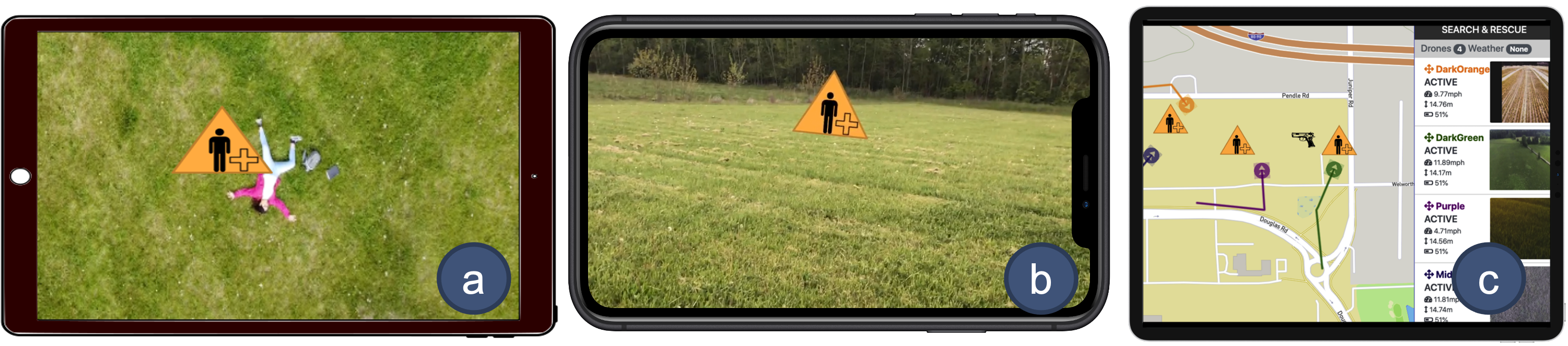
To preserve the geolocation information in a way that can be shared with other UAVs participating in the mission, all symbols corresponding to POIs are persisted in the AR world space of Flying-AR based on their geolocation. As all UAVs share the same AR world space of Flying-AR and as each UAV has its own AR camera, we are able to create a shared augmented reality (Peitso and Michael, 2020) environment. To support the POI visualization for multi-UAV emergency response missions, we leverage the AR world tracking feature of the ARKit platform to render the POI annotated in the aerial video stream of one UAV into the aerial video stream of other UAVs participating in the same mission. Figures 3a and 3b illustrate the multi-UAV POI visualization whilst searching for an injured person. The sequence of events for multi-UAV POI visualization is as follows; first, the victim is detected in the aerial video stream of a UAV (e.g., UAV-1, Figure 3a) and a user marks the victim on the video stream; second, \systemcomputes the geolocation of the injured person and stores it in the shared AR space. Finally, the AR cameras of other UAVs (e.g., UAV-2, Figure 3b) track the same AR space and render the POI overlay into their own video streams when the POI appears within their camera’s field of view.
3.2. FirstResponse-AR
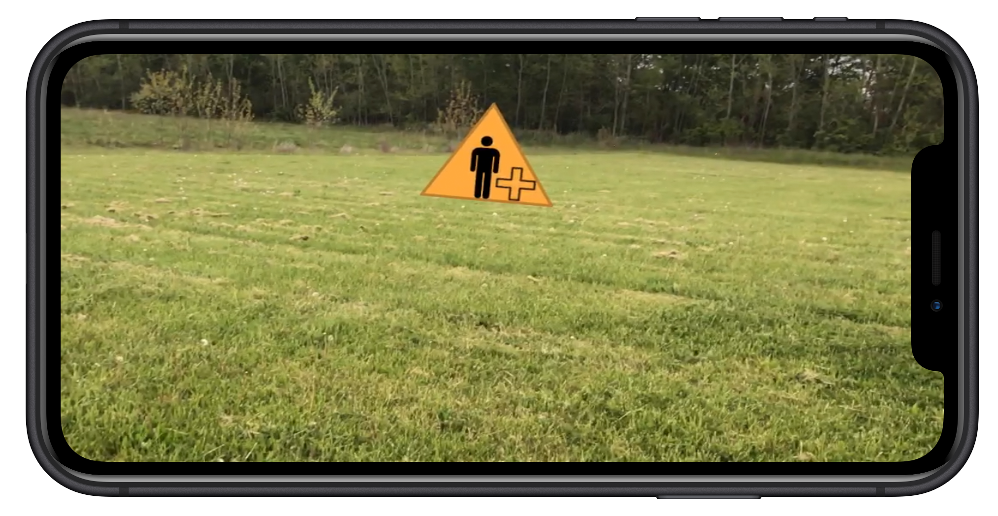
FirstResponse-AR is a Location-Based AR application that allows the On-Scene First Response team to visualize geolocated scene information from the first-person perspective using head-mounted displays, mobile devices, or AR glasses. FirstResponse-AR creates its own AR space; however, it constantly synchronizes the geolocations of POIs from the AR space of Flying-AR using the backend component of the \systemover secured Wi-Fi channels. The AR camera of the FirstResponse-AR application mimics the GPS position, orientation, and camera properties such as Field-of-View of the first responders’ device in the AR world space. This enables FirstResponse-AR to track the AR world space according to the movements of the first responder in the real world. FirstResponse-AR also leverages ARKit’s (AR-, 2021) world tracking feature to augment the POI symbol in the first responders’ view based on geolocations of the POI and the first responders’ device. The FirstResponse-AR interface extends Campos et al., THEMIS-AR (Campos et al., 2019) design for use in a multi-UAV domain. While THEMIS-AR requires humans to manually provide the geolocation of the POI in the form of GPS coordinates, our solution lifts this limitation by automatically computing the geolocations of POIs based on annotations in the video stream. Additionally, FirstResponse-AR leverages web-socket connections over Wi-Fi and LTE channels to exchange data such as geolocation of POIs with other emergency response tools. Hence, the extensible design of FirstResponse-AR allows it to receive GPS locations of POI at run-time from UAVs, Mission-Control , Flying-AR , and can work in conjunction with other emergency rescue tools. Figure 4b shows the FirstResponse-AR application interface.
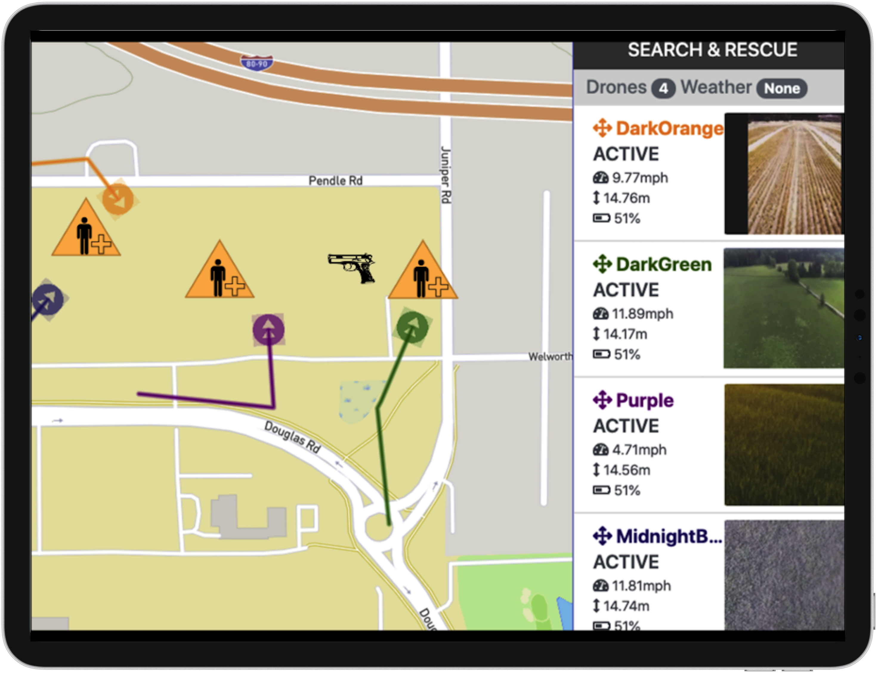
3.3. Mission-Control
The Mission Planning Team leverages the Mission-Control interface to visualize the overview of the mission, allowing the team to plan and discuss different execution strategies as the mission unfolds. The Mission-Control interface is implemented as a Web application using the Angular (Jain et al., 2014) web framework and displays video streams and UAV location and status, while Mission-Control is deployed on a web server, where it enables each member of the Mission Planning team to access the status of the mission on their devices. It extends the design of previous multi-UAV interfaces from the literature (Agrawal et al., 2020a) by (i) receiving information from multiple rescue teams and visualizing it on 2D maps, and (ii) broadcasting Geo-Locations of POIs to UAVs and other stakeholders of the mission. Figure 4a shows the Mission-Control interface. The team interacts with the user interface to perform tasks such as plan flight routes, assigning tasks to specific UAVs, and annotating maps with scene information using labels and icons. Whenever a scene update is received for a new piece of geo-locatable information, Mission-Control synchronizes the information to all devices and immediately displays it on the map, reducing the need for redundant communication amongst distributed members of the Mission Planning Team.
3.4. Collaboration
supports collaboration through a back-end component that persists the geolocation of all POIs annotated by either the rescue team members or UAVs themselves. The back-end is built using Node.js, and deployed as a web service on a private cloud server using web sockets to broadcast data in real-time. The back-end component tracks the geolocation, type of POI, information source (e.g., rescue team ID), and other properties of the shared data. Each member of the rescue team is equipped with a mobile device which communicates with the node.js web service to synchronize the latest information in the UI. We describe two primary scenarios for illustrating the usability of \systemin visualizing the situational information and supporting collaborative work whilst using UAVs for emergency response.
3.4.1. Human Knowledge Sharing
In the river search and rescue scenario, autonomous UAVs search the river for drowning victim(s) whilst continually streaming video. Team members, including the Remote Operations Monitoring Team, examine aerial video streams for information that could be important for the search mission, such as clothing, a capsized canoe, or submerged branches in which a victim might get trapped. While the UAV video streams can provide mission-critical information; precisely communicating this information across multiple rescue teams remains challenging due to the difficulty of verbally describing geographic locations. As highlighted in Figure 2, the Flying-AR interface, supported by the AR environment, is designed to enable high degrees of collaboration between team members monitoring the video stream and those enacting actual operations at the scene of the incident. The enhanced situational awareness provided by Flying-AR enables timely planning and more effective mission execution.
The geolocation of all POIs is shared with all UAVs participating in the mission through the same back-end component of RescueAR. Given a certain degree of autonomy, the UAVs can leverage this information to adjust their flight plans and actions accordingly. In summary, \systemallows key mission information to be shared in close to real-time to all mission participants, including UAVs, in a format that facilitates comprehension and actions. Figure 5a provides an overview of the scenario.
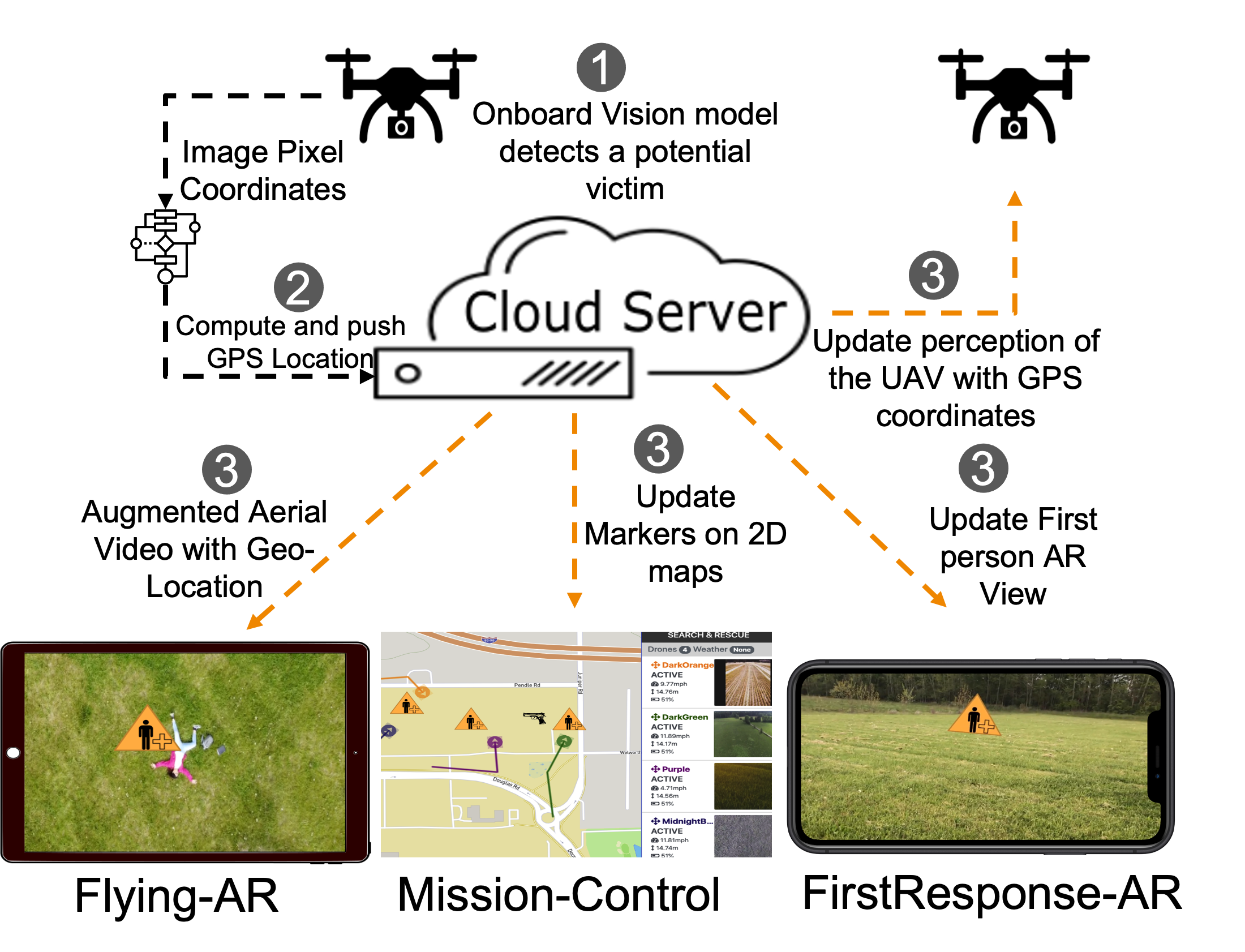
3.4.2. UAV Knowledge Distribution
Companion computers onboard the UAVs enable them to act and perform tasks independently. These companion computers, such as Nvidia Jetson Nano (Jet, 2021), run complex planning (Allaire et al., 2008; Zhou et al., 2020), vision (Timotheatos et al., 2018; Yang et al., 2019), and adaptation algorithms (Zhang et al., 2018) that allow UAVs to sense, plan, and act in the environment. During a river search and rescue operation, the onboard companion computer performs the computations described in section 3.1 to transform the pixel coordinates of the point of interest recognized by the onboard vision algorithms into its corresponding Geo-location. The UAV pushes geolocation of POIs to the back-end component for broadcasting. This allows a UAV to directly share information with all stakeholders, including other UAVs participating in the mission. The mission planning team visualizes the POIs in the form of icons on 2D maps. The world tracking feature of the Flying AR interface enables members of the remote operations monitoring team to visualize the UAV recognized POIs on the aerial video streams of all UAVs. Likewise, the on Scene First Response team members visualize the incoming information from UAVs in the first-person view on the ground. Figure 5b provides an overview of the scenario.
4. Experiments and Analysis
The objective of our study was two-fold: (i) to evaluate the effectiveness of the \systemin computing the geolocations of POIs in the aerial video stream, and (ii) to analyze the usability of Flying-AR in creating and sharing the AR content, and then consuming the AR content as overlays on aerial video stream to understand the scene, and communicating the scene information to rescue team stakeholders. We conducted our user studies after approval from the local institutional research board. For aerial video analysis, we leveraged a commercial grade UAV equipped with a 3-axis Gimbal and an RGB camera to record aerial videos of our testing site. Table 1 describes the relevant specifications of the UAV used in all of our studies.
| Aircraft | |
| Manufacturer | DJI |
| Model | Mavic Mini 2 |
| Takeoff Weight | 249 g |
| Dimensions | 245 X 289 X 55 mm (LXWXH) |
| Max Flight Time | 30 minutes |
| Hovering accuracy (GPS based) | ±0.5 meters |
| Gimbal | |
| Stabilization | 3-axis |
| Pitch / Tilt range | -90 to 0 ∘ |
| Camera | |
| Sensor Size | 1/2.3” CMOS |
| Effective Pixels | 12 MP |
| Lens FOV | 83 ∘ |
4.1. Geo-Location Computation Analysis
We conducted a preliminary analysis to identify the suitability of \systemin real world conditions. Specifically, we assessed its ability to compute geolocations of objects based on the image pixel coordinates in their aerial video frames.
4.1.1. Data Collection
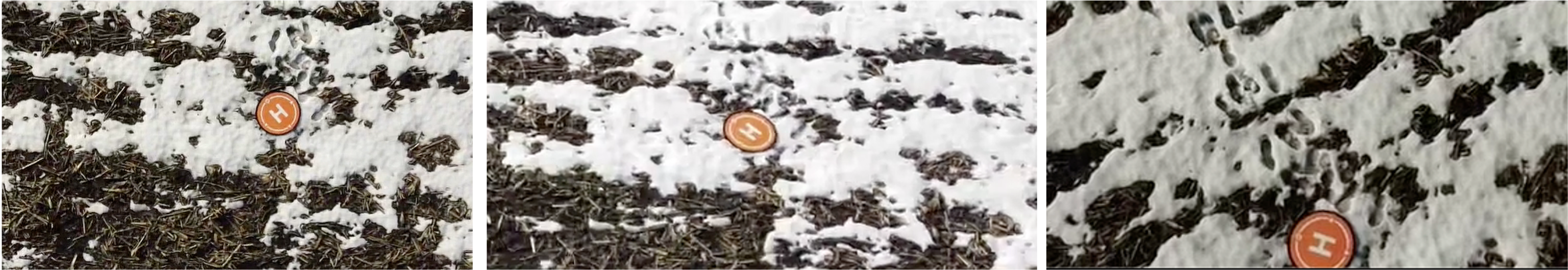
For preliminary testing purposes, we manually operated the UAV so that we could capture diverse views of a target object in the aerial video frame, varying the drone’s altitude, position, orientation (yaw, pitch, roll), and gimbal orientation. Figure 6 presents a few samples from our video collection showing the target object from various drone altitudes, camera angles, and screen positions. In total, we collected three aerial videos of the scene along with their flight logs, with an average flight time of 3 minutes 4 seconds. Finally, to create approximate ‘ground truth’ about the actual location of the target object, we used Coordinates, an iOS mobile application (Coo, 2021) to collect its GPS coordinates and refer to these as measured coordinates in the remainder of this discussion. For analysis purposes, we compared the measured geolocation of the target object with its computed geolocation.
4.1.2. Analysis of Geo-Tagging Accuracy
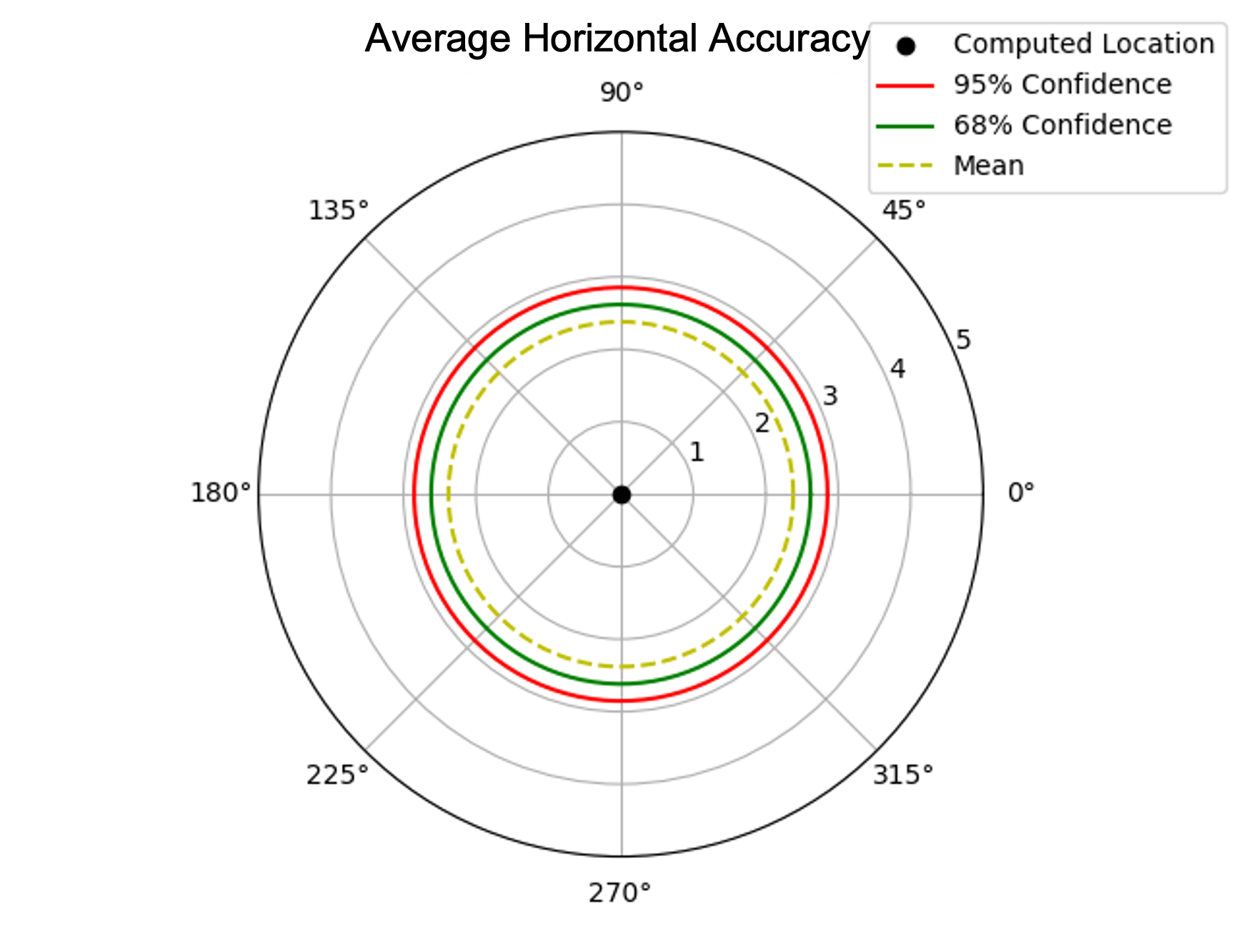
We started by annotating the target objects in the aerial video stream using Flying-AR . The first author created 91 annotations of target objects in the aerial videos, and recorded their computed geolocations for analysis purposes. We used distance between the calculated and measured co-ordinates of the target object to estimate the horizontal accuracy of our computed geolocations. Figure 7a shows the mean horizontal accuracy of the calculated geolocations of the target objects. Each circle in Figure 7a indicates the estimated distance (in meters) at which the measured geolocation of the target would lie from the computed geolocation (center). The red circle indicates that 99% of the time, the distance between the computed geolocation and the actual geolocation will be less than 3 meters, whilst the green circle indicates that 68% of the time, the computed geolocation will lie within 2.6 meters of the measured geolocation.
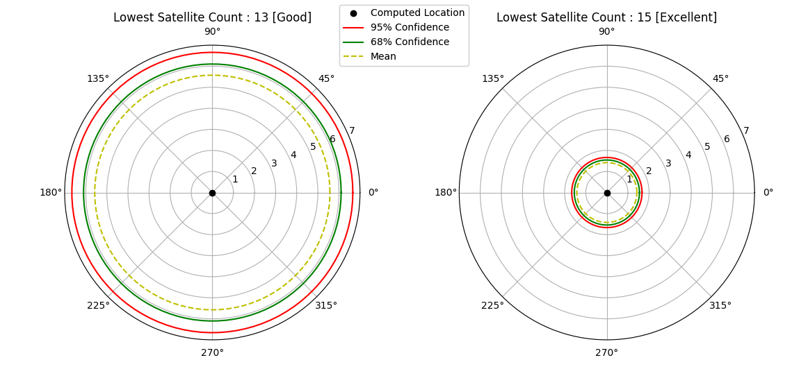
Since our POI geolocation computations depend on the GPS location of the UAV as described in Section 3.1, we analyzed the efficiency of our approach under varying UAVs’ GPS signal strength. The satellite count available for the GPS device onboard the UAV determines the quality of GPS signal reception. According to the flight logs analysis tool called AirData (Dro, 2021), availability of at least 13 satellite signals is required for safe flying, and a satellite count below 13 is considered to create poor or dangerous situations for flying. Therefore, we separated our analysis based on UAV’s lowest satellite reception count; 15 (excellent flying conditions) and 13 (good flying conditions).
First, we found that the accuracy of the target geolocation computation improves as the number of available satellite count increases. Second, we observed that under excellent signal strength (i.e., satellite count above 15), the mean accuracy is within 2 meters. However, the mean accuracy degrades to within 7 meters when the satellite counts drop to 13. As a result, an object marked in the video stream of one UAV can be expected to appear within 2 meters of another UAV’s video stream, provided there are at least 15 satellites available for UAVs’ GPS. Figure 8 illustrates the results of the computed accuracy of target object geolocation when UAVs’ GPS quality is good and excellent. In addition, the results of the experiment enable us to surround the POI with an uncertainty circle, providing the user with a clear understanding of the POI’s true location.
4.2. Usability Analysis of Flying-AR
4.2.1. Study Participants
We recruited six participants (five men and one woman) from our network. Four of them had experience in operating UAVs or developing UAV applications. The other two were researchers in the Software Engineering domain. All participants’ ages ranged between 18 and 34. Four of them had prior knowledge of AR technologies.
4.2.2. Study Method
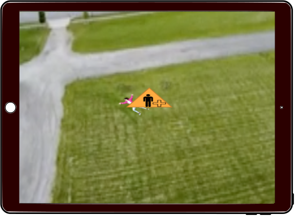
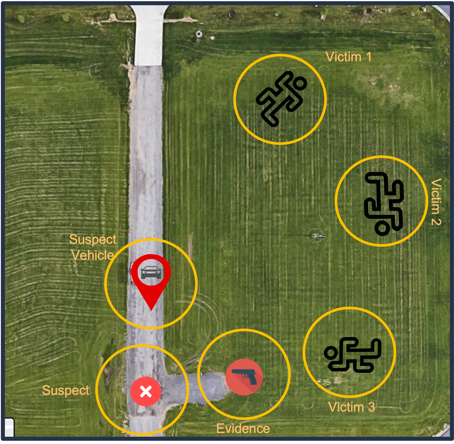
To support our user study, we recruited three volunteers to help us enact the scene of a shooting incident. Two volunteers and the first author acted as injured victims in the park, whilst one played the role of the shooter dropping a toy gun on the ground whilst running through a park. The UAV flew autonomously in mission mode to survey the crime scene, capturing videos for use in our study. Figure 7b depicts the enacted scene including the location of injured victims, the toy gun - dropped by the suspect (evidence), the suspect’s last known location, and his probable vehicle. As part of our study, we selected the shooting event because it was easier to enact in the real world than other incidents such as river searches or fire surveillance.
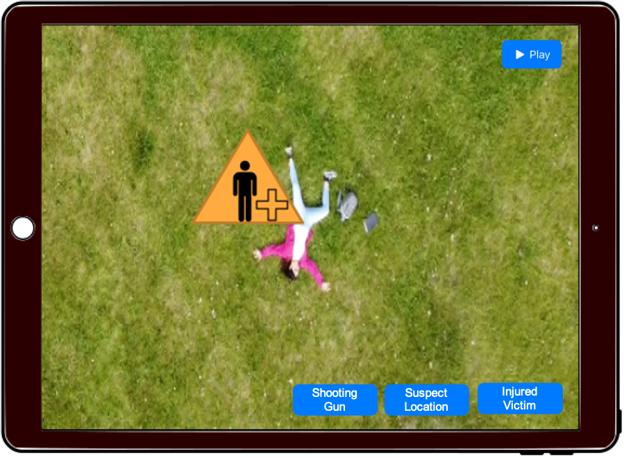
We used the recorded aerial video stream of the artificial shooting event as described above to analyze the usability of our system. In preparation for the user study, we seeded the AR world space by using Flying-AR ’s annotation feature to add the gun as a POI so that it appeared in UI’s presented to users in our study.
During our study session we first obtained participants’ consent for the study, and then provided an overview of \systemto familiarize them with the kinds of use-cases it would support. Second, we demonstrated Flying-AR ’s interface and asked participants to test out the annotation tool by marking a random object in an aerial video stream. Once they acknowledged confidence in using the interface, we assigned a task of monitoring the video stream of our enacted crime scene activity to: (i) acknowledge any information shared by other rescue team members or UAVs that might help them to develop an understanding of the crime scene, and (ii) annotate POIs in the aerial video stream with their corresponding symbols in order to share the information with other rescue team members.
When participants were interacting with our system, we also recorded the screen and mouse clicks to identify any interaction pattern that participants specifically followed to complete the task. Soon after task completion, we asked participants to fill out a questionnaire and then conducted a brief follow-up interview to elicit further comments and suggestions for improvement.
4.2.3. Results and Discussion
We divided the post-task questionnaire into four sections. The first part of the questionnaire focused on evaluating Flying-AR ’s performance on six parameters (attractiveness, perspicuity, efficiency, dependability, simulation and novelty) using a standard User Experience Quality (UEQ) scale (Laugwitz et al., 2008). The second part evaluated the overall system’s usability under real-world conditions using System Usability Scale (SUS) (Bangor et al., 2008). In the third part, we asked participants to rate the usefulness of each Flying-AR feature on a 7 point Likert scale using the questionnaire shown in Table 2, and finally, we asked participants to think aloud throughout the study and to provide us with insights for ways to improve the usability of \system. Participants did not receive any compensation for participating in, or completing the study. We now describe our analysis in relation to each part of the questionnaire.
| Flying-AR Feature | Statements in our Survey |
|---|---|
| Pause Video Before Annotation | The ability to pause a video and annotate it with objects was very useful to me. |
| Object Selection | The Object Selection Panel at the bottom was useful to pick which objects I wanted to annotate. |
| Supports Scene Spatial Understanding | The Gun icon gave me a good idea of where it’s positioned in relation to other Vehicles in the Scene. |
| GeoLocation Persistence | It was useful that the system automatically stored my annotations on the video and shared them with other members of the rescue team. I do not have to share it verbally with others over the radio. |
| POI Visualization (shared by others) | I would probably have difficulty finding the gun in the video if the gun icon did not appear automatically. |
| Maintain Consistency across teams | I think it is better to see the evidence icons in the video stream rather than hearing where it was found over the phone or radio. |
-
•
User Experience: Figure 9 (Left) provides UEQ mean scores across six dimensions. The standard deviation and confidence interval for each scale are shown. In general, the participants had a positive experience, and reported that they found Flying-AR to be an innovative solution for sharing information during UAV based emergency response missions, with a mean score of 2.33 for Novelty. One participant mentioned “I think that the system would be very useful, and it was definitely helpful being able to see the icons set up by both the teams on the ground and in charge of the aerial view. Overall, I would say that this is a very valuable tool”. UEQ results also indicate potential for improvements in Dependability and Efficiency aspects of the interface. Therefore, the first author of the paper reviewed participants’ feedback comments to identify improvement opportunities.
-
•
Feedback: First, two participants suggested adding the capability to rewind the aerial video stream to annotate fast-moving POIs. One of them mentioned “ For fast moving objects such as suspect, it may be useful to add a feature to rewind a video”. This feature would also support rescue team members in revisiting existing annotations. Another participant felt the need to be able to zoom into the video to closely analyze small objects in the scene such as a gun and mentioned “there can also be a zoom feature for the video”. Third, two participants reported difficulties when using the UI buttons to mark objects in the aerial video stream, saying “sometimes it is stressful to mark the targets however just because it is sort of hard to press the buttons…, but I would like to use a keyboard to press [buttons on the UI]”. Another participant also suggested providing “ shortcuts to select the options like gun, suspect, play, pause, etc.” as “It would make it much easier to operate”. We anticipate that providing multiple annotation methods such as keyboard shortcuts and drag-and-drop markers would improve efficiency and support diverse user interaction preferences.
In the context of enhancing the situational awareness of the operators monitoring the aerial video stream, one participant suggested overlaying arrows on the edge of the aerial video stream pointing towards the POIs in the affected area. The participant said “if there is nothing on the screen, like the times there was just grass, there could be arrows on the edges of the screen. These arrows would be pointing in the direction of where something has been marked. These arrows could be labeled with what has been marked”. By doing so, users would be able to gain an understanding of the situation that extends beyond what is visible in the aerial video stream. As an example, if a police officer on the ground identifies critical evidence and transmits its geolocation to \system, the arrows pointing towards the evidence will benefit the rescue team in two ways. First, the direction of the arrow will allow the remote operator to understand the location of the evidence in relation to the current location of the UAV. Second, the operator may choose to use the arrows to guide the UAV towards the evidence for a closer aerial inspection and marking annotations.
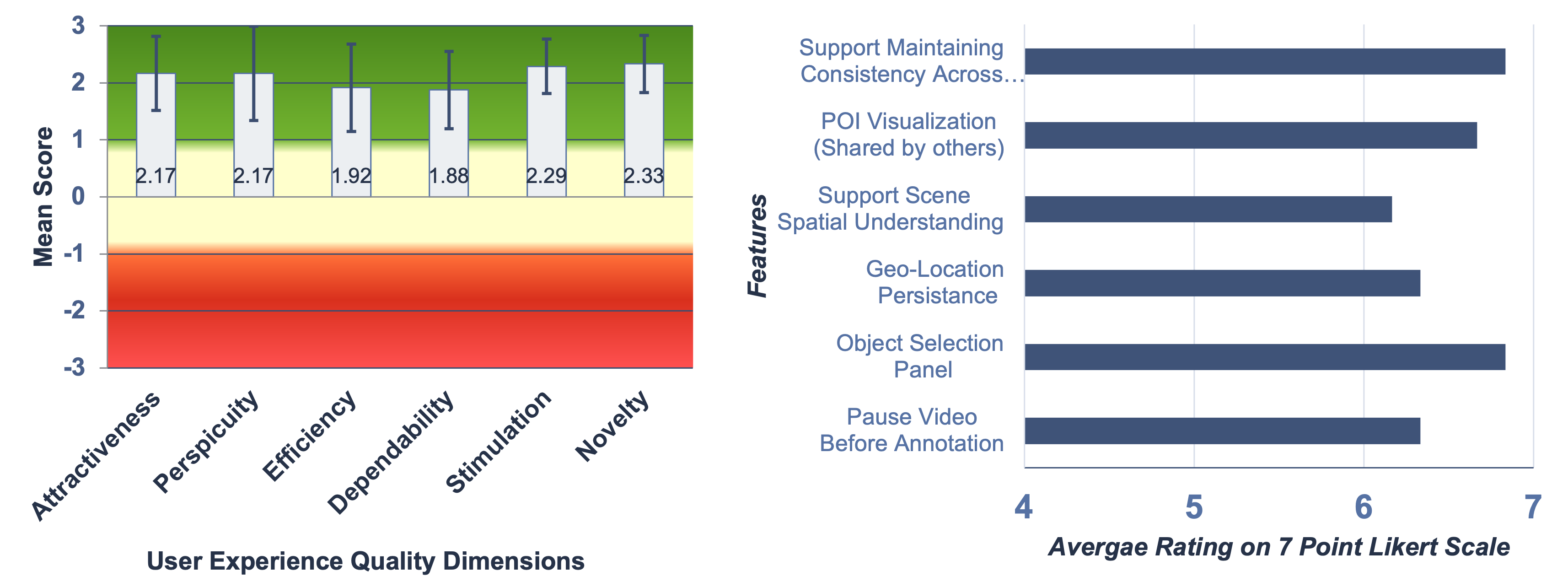
Figure 9. User Study Results : (Left) Flying-AR User Experience Quality Results, (Right) Flying-AR Features Usefulness -
•
Usability : Based on the participants’ responses to the statements described in Table 2, we summarize the usefulness of each Flying-AR feature in Figure 9 (Right). Participants strongly agreed that visualizing the POIs shared by other rescue team members as overlays on the aerial video stream is useful and directly supports awareness of the situation across multiple teams. When multiple POIs were available in a single frame, the POI visualization also improved the participant’s spatial understanding of the scene. Participants also found other features very useful such as persistence of information, ability to pause the video stream before annotating it, and object selection panel at the bottom for picking objects. However, as the scenario gets more complex in the real world, putting many labelled buttons at the bottom of the screen might clutter the interface. In such case, we believe replacing labels with icons on the buttons at the bottom might be more useful for providing quick access to many annotation objects. Finally, we compute an SUS score of 94.6, which, based on the adjective rating scale (Bangor et al., 2009) can be defined as Excellent (where 25 represents the worst imaginable, and 100 represents the best imaginable).
Overall, the study participants found our system to be useful and reported positive experiences with it. The participants provided valuable UX recommendations to consider for improving UI design of Flying-AR .
5. Stakeholders Perspectives
To gain a deeper understanding of emergency rescue teams’ communication needs and to understand how \systemcan be leveraged and improved to serve those needs during the course of investigations, we reached police officers from a local law enforcement agency and conducted a one-hour focus group session (Morgan, 1996). During this session we (i) explored the challenges they face when communicating with each other during emergency response situations such as mass shootings, (ii) asked whether \systemcould alleviate some of those challenges, if so, how? (iii) gathered feedback regarding how \systemcould be utilized in real-world emergency circumstances, and finally (iv) discussed opportunities for conducting field exercises in the future.
5.1. Participants
Invitations to the focus group were sent via emails and resulted in participation of five police officers (four Male and one Female). Table 3 describes the participant’s backgrounds.
| Participant Id | Current Designation | Years of Service | Experience with UAVs |
|---|---|---|---|
| P1 | Police Chief | 17 | None |
| P2 | Deputy Chief of Police | 27 | 1-3 years |
| P3 | Assistant Police Chief | 40 | Occasional at Incident Scenes |
| P4 | Special Events Program Manager | 15 | 0-1 Years |
| P5 | Deputy Chief Safety Services | 34 | None |
5.2. Procedure
We opted to conduct a focus group, because they have been shown to increase the likelihood of discovering a wide variety of attitudes, knowledge, and experiences in one session. The first and second authors facilitated the focus group, and the second author also took notes during the session for analysis. Participants of the focus group were asked to discuss openly their experiences, attitudes, and opinions.
We opened the session with a presentation of the overarching goal of leveraging UAVs as partners in emergency response missions such as river search and rescue and fire surveillance, and city surveillance, and then drew on news articles detailing how police have previously used drones in emergency situations to inspire their thinking about UAV use. We then asked them about their current communication practices and challenges during emergencies.
In the second half of the session, we introduced the participants to \systemas a tool for sharing geolocation information. We also presented videos of each of the Flying-AR , FirstResponse-AR , and Mission-Control interfaces created from the enacted shooting scene described in Section 4. Finally, we asked the participants to complete a five-minute survey questionnaire in order to capture their views and opinions about the system. The entire focus group session was completed in one hour.
5.3. Findings
5.3.1. Challenges in current communication system
During the session, the police officers confirmed our previous understanding that they communicated primarily verbally via radio. However, they also explained that they had tablets in each police car which they used to exchange written communication. Most participants agreed that radio communication suffers from excessive chatter and that superfluous information is frequently broadcast when multiple people talk or communicate simultaneously. Moreover, P5 pointed out that, in large-scale operations, this can create a chaotic situation, resulting in confusion among rescue personnel. P1 also stated that radio communications between dispatchers and callers can be frustrating due to the time-sensitive nature of the situation. While discussing how geolocation information is communicated over the radio and how police officers interpret it, we learned that officers frequently refer to landmarks, roads, buildings, and other known entities in their environment. In this context, P1 shared that it can be difficult identifying locations when several buildings have similar names.
Their current communication infrastructure lacked the capability to visualize information in any form. However, Flying-AR and FirstResponse-AR interfaces could alleviate this problem by enabling team members to use POI markers to share and interpret geolocation information during an emergency response.
5.3.2. geolocation importance
Police officers reported that geolocation assists them in many ways – for example, by narrowing down their search or containment areas. They also agreed that tracking down a suspect becomes easier if the suspect’s past geolocations are known. In the context of a mass shooting crime scene, police officers determined that the location of victims, suspects, evidence, and danger areas are of critical importance. Further, they suggested reducing the types of icons to use for POI markers to include only the essential types. \systemcan be customized to allow tagging aerial video stream with a limited set of markers appropriate to each scenario type.
5.3.3. Design
The police officers also suggested the following ways to improve the design of \system, in order to address the police officers’ real-world needs.
-
•
Suspect Tracking: Police officers found it helpful to mark suspects in the aerial video stream in order to determine their geolocation. They expressed interest in the UAV to tracking the suspect and for Flying-AR to move the POI marker according to the suspects’ last known position. Integrating a tracking feature into Flying-AR requires extending its implementation to continuously update the POI symbols in the AR space to reflect the last known geolocation of the suspect.
-
•
Textual Annotations: In addition to using markers or symbols, police officers suggested placing textual annotations in the scene via Flying-AR . They believed that on-scene rescue teams would benefit from a detailed textual description of specific POIs, such as the model of a gun and the type of bullet found on the crime scene.
-
•
Annotation Modifications: Police officers are often required to confirm the presence of evidence during an investigation. Therefore, our participants suggested that on-scene responders should be able to move, delete, or even add new POIs using FirstResponse-AR. This would allow a police office to augment, correct, or create information that would then be available to all team memebers, including UAVs, via Flying-AR and Mission-Control. As a result, all rescue teams would be able to maintain consistent awareness of the situation.
-
•
System Integration: Finally, our participants also believed that integrating \systemwith other situational awareness tools such as Fuses(fus, 2021) which assists police officers in developing situational awareness of the scene by providing real-time video footage from CCTV cameras. The police chief (P1) demonstrated Fuses to us in order to explain how it helps them in criminal investigations, and discussed the possibility of integrating video imagery from CCTV cameras via Fuses with the more flexible, mobile UAV views via Flying-AR interfaces.
5.3.4. More Applications
Police officers identified several additional use cases. The two that they were most enthralled by were related to major sporting events on the campus and included traffic planning and searching for lost children. Other ideas supported parking services and escort services.
5.3.5. Police Officer’s Perception of \system
| Qs | Statement |
|---|---|
| Q1 | I believe the system’s ability to geolocate POIs could benefit the police officers in carrying out their investigations |
| Q2 | I believe the visualizing the POIs using AR Glasses can assist on-scene officers in quickly assessing the situations |
| Q3 | The system supports police officers in sharing and understanding the geolocation information during emergency response |
| Q4 | The system could be a valuable addition to our existing communication system |
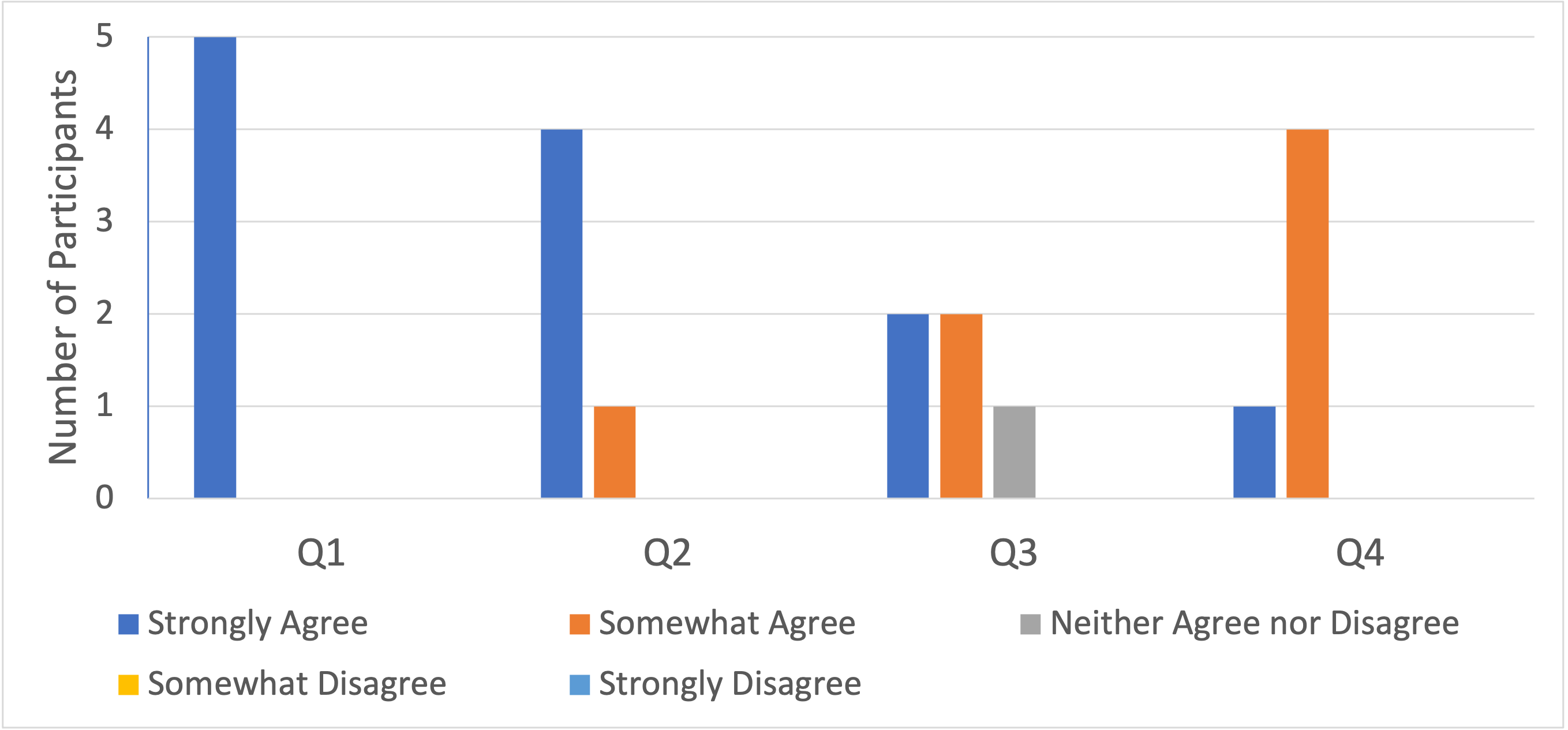
We developed a short questionnaire to obtain feedback from police officers regarding their perception of the usability of the \systemduring crime investigations, and asked police officers to rate their agreement or disagreement with the statements in Table 4 on a 5-point Likert scale. The survey results are shown in Figure 10. All police officers strongly agreed that the ability of the \systemto compute the geolocation would be useful to carry out their investigations. Four strongly agreed, and one moderately agreed that visualizing the critical POIs using AR glasses would allow officers to quickly access the situation. This response suggests that FirstResponse-AR could improve the response time of on Scene emergency rescue teams. Further, police officers believed that the overall system could support teams in sharing and understanding the geolocation information (two strongly agreed, two somewhat agreed, and one neural) and could be a complementary addition to the existing communication system (one strongly agreed, and four somewhat agreed). These responses suggest the positive feedback from the end-users of \systemand support our design concept to improve the communication among rescue teams during emergency response.
6. Discussion and Future Work
Our research proposed a novel system and multiple interfaces for improving information exchange among rescue teams and UAVs during emergency response. Based on our feasibility analysis, usability analysis, and feedback from domain experts, we found that \systempresents a pragmatic approach to alleviate the social and organization challenges of communication enabling multiple rescue teams and UAVs to share and visualize scene information. Our findings in this study inform several insights to design the AR-based communication system for the next-generation UAV-Driven emergency response.
First, domain experts emphasized the importance of geolocations of POIs in the scene. Therefore, it is crucial for Location-Based AR communication systems to determine the geolocations of the target objects in the scene in order to develop a feasible solution. According to our geolocation accuracy analysis discussed in Section 4.1, \systemis able to calculate the geolocation of the target objects in an aerial video stream within a range of 2 meters under ideal conditions, making it a potentially valuable asset for emergency response teams. However, as our solution depends heavily on the GPS accuracy of the UAVs’ position in the air, adding more sensory information to improve the UAVs’ GPS signal quality would enhance the geolocation computation of the target object. For instance, leveraging Real-Time Kinetics (RTK) base stations over GPS, which provide centimeters level accuracy (Stott et al., 2020), could enhance the target geolocation computation in urban areas where UAVs’ GPS accuracy tends to deteriorate.
Second, in our usability study discussed in Section 4.2, we noticed that four out of six users preferred to pause the aerial video before annotating it in order to ensure precision of annotations, whilst some users requested the ability to rewind the live video feed in order to replay parts of it, so that they could have sufficient time to annotate everything in the scene. In the context of this observation, two factors should be taken into consideration when designing Flying-AR . First, if users are allowed to pause and rewind the live video feed during a fast-paced emergency response mission, they will not have time to analyze the incoming video frames for the duration of the pause or for the time required to complete the annotation. Second, preventing the users from pausing the video or rewinding it would prevent them from annotating the video if there are many points of interest within one frame. Thus, in order to assure that users are able to analyze every video frame as well as pause and rewind the live aerial video feed, user interface design choices should be explored. A possible solution could be to use the aerial video buffer to show the aerial video at a fast rate in order to catchup on the time taken for annotating. Thus, future research could examine options for addressing such trade-offs in UX design of Flying-AR . Further, from the perspective of user experience design, we believe that the users should be able to choose whether they wish to skip the video frames or view it at a higher frame rate in such a scenario.
Finally, our study with domain experts discussed in Section 5 provided us with end-user requirements that we should consider while designing AR supported emergency rescue tools. The demonstration of the \systemprototype resulted in an agreement to conduct future field exercises with them to evaluate Flying-AR in a real world setting.
7. Limitations
Our work is subject to several limitations. We have illustrated that the system can provide communication support during the enactment of a shooting incident; however, further analysis is needed for more complex emergency response scenarios. In addition, the system must undergo additional field-testing with police officers and other stakeholders to ensure its robustness. We considered several alternative designs to evaluate the accuracy of our system in computing the geographical location of the target object, including the possibility of collecting and analyzing the data in real-time. We plan to study the robustness of our system during future field tests with stakeholders. However, our approach of using pre-recorded videos of the scene and the geolocation of the target objects allowed us to control the UAVs’ GPS signal strength and to conduct a thorough accuracy analysis of the geolocated POIs. The analysis can be extended to high-speed UAVs flying at much higher altitudes. Another threat is related to the experience of participants in the focus group. While all police officers have served for more than 15 years in the department, their experience in the use of UAVs was limited, and two police officers had no experience in working alongside UAVs. Therefore, we anticipate more use-cases and design improvements for our UAV-based emergency response system.
8. Conclusion
In this paper, we have shared our vision for using AR during emergency response to make geolocation information more accessible in order to support informed and quick decision-making. We introduced RescueAR, a location-based Augmented Reality platform that consists of three different user interfaces: Flying-AR, FirstResponse-AR, and Mission-Control. These interfaces allow rescue personnel and UAVs to share and visualize geolocated POIs using AR. We conducted multiple studies, including a focus group session with end-users of our platform, to study the feasibility and usability of \systemin the real world. We found that \systemis capable of calculating the geolocation of POIs in the scene within a range of 2 meters under ideal conditions. In addition, participants in our usability study indicated that Flying-AR assists rescue team members in maintaining a consistent awareness of the scene. In our focus group discussion, police officers also expressed their belief that our system has the potential to benefit law enforcement agencies in the course of investigations, and could be a valuable addition to their existing communication systems. Finally, we also identified design implications for building future collaborative UAV driven AR systems.
9. Acknowledgements
Double blinded
References
- (1)
- AR- (2021) 2021. Augmented Reality - Apple Developer. https://developer.apple.com/augmented-reality/. (Accessed on 04/15/2021).
- Coo (2021) 2021. Coordinates - GPS Formatter on the App Store. https://apps.apple.com/us/app/coordinates-gps-formatter/id494286614. (Accessed on 09/06/2021).
- Dro (2021) 2021. Drone Data Management and Flight Analysis — Airdata UAV. https://airdata.com/. (Accessed on 07/29/2021).
- fus (2021) 2021. fūsusONE™: Real-Time Crime Center Software In The Cloud. https://www.fusus.com/rtc3-products/fususone. (Accessed on 08/21/2021).
- Jet (2021) 2021. Jetson Nano - eLinux.org. https://elinux.org/Jetson_Nano. (Accessed on 07/05/2021).
- Abraham et al. (2021) Sophia Abraham, Zachariah Carmichael, Sreya Banerjee, Rosaura VidalMata, Ankit Agrawal, Md Nafee Al Islam, Walter Scheirer, and Jane Cleland-Huang. 2021. Adaptive Autonomy in Human-on-the-Loop Vision-Based Robotics Systems. arXiv preprint arXiv:2103.15053 (2021).
- Agrawal et al. (2020a) Ankit Agrawal, Sophia J Abraham, Benjamin Burger, Chichi Christine, Luke Fraser, John M Hoeksema, Sarah Hwang, Elizabeth Travnik, Shreya Kumar, Walter Scheirer, et al. 2020a. The next generation of human-drone partnerships: Co-designing an emergency response system. In Proceedings of the 2020 CHI Conference on Human Factors in Computing Systems. 1–13.
- Agrawal et al. (2020b) Ankit Agrawal, Jane Cleland-Huang, and Jan-Philipp Stegh”ofer. 2020b. Model-Driven Requirements for Humans-on-the-Loop Multi-UAV Missions. In 2020 IEEE Tenth International Model-Driven Requirements Engineering (MoDRE). IEEE, 1–10.
- Allaire et al. (2008) François CJ Allaire, Mohamed Tarbouchi, Gilles Labonté, and Giovanni Fusina. 2008. FPGA implementation of genetic algorithm for UAV real-time path planning. In Unmanned Aircraft Systems. Springer, 495–510.
- Andreassen et al. (2020) Natalia Andreassen, Odd Jarl Borch, and Are Kristoffer Sydnes. 2020. Information sharing and emergency response coordination. Safety Science 130 (2020), 104895.
- Aydin et al. (2019) Burchan Aydin, Emre Selvi, Jian Tao, and Michael J Starek. 2019. Use of fire-extinguishing balls for a conceptual system of drone-assisted wildfire fighting. Drones 3, 1 (2019), 17.
- Bangor et al. (2009) Aaron Bangor, Philip Kortum, and James Miller. 2009. Determining what individual SUS scores mean: Adding an adjective rating scale. Journal of usability studies 4, 3 (2009), 114–123.
- Bangor et al. (2008) Aaron Bangor, Philip T Kortum, and James T Miller. 2008. An empirical evaluation of the system usability scale. Intl. Journal of Human–Computer Interaction 24, 6 (2008), 574–594.
- Basso et al. (2018) Maik Basso, Iulisloi Zacarias, Carlos Eduardo Tussi Leite, Haijun Wang, and Edison Pignaton de Freitas. 2018. A Practical Deployment of a Communication Infrastructure to Support the Employment of Multiple Surveillance Drones Systems. Drones 2, 3 (2018), 26.
- Bellamy et al. (2017) Rachel KE Bellamy, Sean Andrist, Timothy Bickmore, Elizabeth F Churchill, and Thomas Erickson. 2017. Human-agent collaboration: Can an agent be a partner?. In Proceedings of the 2017 CHI Conference Extended Abstracts on Human Factors in Computing Systems. 1289–1294.
- Bergstrand and Landgren (2009) Fredrik Bergstrand and Jonas Landgren. 2009. Information sharing using live video in emergency response work. In Proceedings of the 6th International ISCRAM Conference. Citeseer, 1–5.
- Campos et al. (2019) Alexandre Campos, Nuno Correia, Teresa Romão, Isabel Nunes, and Mário Simões-Marques. 2019. Mobile augmented reality techniques for emergency response. In Proceedings of the 16th EAI International Conference on Mobile and Ubiquitous Systems: Computing, Networking and Services. 31–39.
- Carozza et al. (2014) Ludovico Carozza, David Tingdahl, Frédéric Bosché, and Luc Van Gool. 2014. Markerless vision-based augmented reality for urban planning. Computer-Aided Civil and Infrastructure Engineering 29, 1 (2014), 2–17.
- Cleland-Huang and Agrawal (2020) Jane Cleland-Huang and Ankit Agrawal. 2020. Human-drone interactions with semi-autonomous cohorts of collaborating drones. arXiv preprint arXiv:2010.04101 (2020).
- Cleland-Huang et al. (2020) Jane Cleland-Huang, Ankit Agrawal, Md Nafee Al Islam, Eric Tsai, Maxime Van Speybroeck, and Michael Vierhauser. 2020. Requirements-driven configuration of emergency response missions with small aerial vehicles. In Proceedings of the 24th ACM Conference on Systems and Software Product Line: Volume A-Volume A. 1–12.
- Domova et al. (2020) Veronika Domova, Erik Gärtner, Fredrik Präntare, Martin Pallin, Johan Källström, and Nikita Korzhitskii. 2020. Improving Usability of Search and Rescue Decision Support Systems: WARA-PS Case Study. In 2020 25th IEEE International Conference on Emerging Technologies and Factory Automation (ETFA), Vol. 1. IEEE, 1251–1254.
- Floreano and Wood (2015) Dario Floreano and Robert J Wood. 2015. Science, technology and the future of small autonomous drones. Nature 521, 7553 (2015), 460–466.
- Gauglitz et al. (2014) Steffen Gauglitz, Benjamin Nuernberger, Matthew Turk, and Tobias Höllerer. 2014. World-stabilized annotations and virtual scene navigation for remote collaboration. In Proceedings of the 27th annual ACM symposium on User interface software and technology. 449–459.
- Guntha et al. (2020) Ramesh Guntha, Sethuraman N Rao, and Maneesha V Ramesh. 2020. Architectural Considerations for Building a Robust Crowdsourced Disaster Relief Application. In 2020 International Conference on COMmunication Systems & NETworkS (COMSNETS). IEEE, 638–641.
- Haas (2014) John K Haas. 2014. A history of the unity game engine. (2014).
- Jain et al. (2014) Nilesh Jain, Ashok Bhansali, and Deepak Mehta. 2014. AngularJS: A modern MVC framework in JavaScript. Journal of Global Research in Computer Science 5, 12 (2014), 17–23.
- Jayapandian (2019) N Jayapandian. 2019. Cloud Enabled Smart Firefighting Drone Using Internet of Things. In 2019 International Conference on Smart Systems and Inventive Technology (ICSSIT). IEEE, 1079–1083.
- Jones et al. (2016) Brennan Jones, Kody Dillman, Richard Tang, Anthony Tang, Ehud Sharlin, Lora Oehlberg, Carman Neustaedter, and Scott Bateman. 2016. Elevating communication, collaboration, and shared experiences in mobile video through drones. In Proceedings of the 2016 ACM Conference on Designing Interactive Systems. 1123–1135.
- Kato and Billinghurst (1999) Hirokazu Kato and Mark Billinghurst. 1999. Marker tracking and hmd calibration for a video-based augmented reality conferencing system. In Proceedings 2nd IEEE and ACM International Workshop on Augmented Reality (IWAR’99). IEEE, 85–94.
- Khan et al. (2014) Asif Khan, Evsen Yanmaz, and Bernhard Rinner. 2014. Information merging in multi-UAV cooperative search. In 2014 IEEE international conference on robotics and automation (ICRA). IEEE, 3122–3129.
- Khan and Neustaedter (2019) Md Nafiz Hasan Khan and Carman Neustaedter. 2019. An exploratory study of the use of drones for assisting firefighters during emergency situations. In Proceedings of the 2019 CHI Conference on Human Factors in Computing Systems. 1–14.
- Klien et al. (2004) Glen Klien, David D Woods, Jeffrey M Bradshaw, Robert R Hoffman, and Paul J Feltovich. 2004. Ten challenges for making automation a” team player” in joint human-agent activity. IEEE Intelligent Systems 19, 6 (2004), 91–95.
- Laugwitz et al. (2008) Bettina Laugwitz, Theo Held, and Martin Schrepp. 2008. Construction and evaluation of a user experience questionnaire. In Symposium of the Austrian HCI and usability engineering group. Springer, 63–76.
- Leebmann (2004) Johannes Leebmann. 2004. An augmented reality system for earthquake disaster response. International Archives of the Photogrammetry, Remote Sensing and Spatial Information Sciences 34, Part XXX (2004).
- López et al. (2017) Luis Bausá López, Niels Van Manen, Erik Van der Zee, and Steven Bos. 2017. DroneAlert: Autonomous drones for emergency response. In Multi-Technology Positioning. Springer, 303–321.
- Manoj and Baker (2007) Balakrishan S Manoj and Alexandra Hubenko Baker. 2007. Communication challenges in emergency response. Commun. ACM 50, 3 (2007), 51–53.
- Marinova (2018) Silvia T Marinova. 2018. New Map Symbol System for Disaster Management. In Proceedings of the ICA, Vol. 1. 74.
- Masoni et al. (2017) Riccardo Masoni, Francesco Ferrise, Monica Bordegoni, Michele Gattullo, Antonio E Uva, Michele Fiorentino, Ernesto Carrabba, and Michele Di Donato. 2017. Supporting remote maintenance in industry 4.0 through augmented reality. Procedia manufacturing 11 (2017), 1296–1302.
- Mather et al. (2017) CA Mather, Tony Barnett, Vlasti Broucek, Annette Saunders, Darren Grattidge, and Weidong Huang. 2017. Helping hands: using augmented reality to provide remote guidance to health professionals. Studies in health technology and informatics 241 (2017), 57–62.
- Morgan (1996) David L Morgan. 1996. Focus groups as qualitative research. Vol. 16. Sage publications.
- Mourtzis et al. (2017a) Dimitris Mourtzis, Aikaterini Vlachou, and Vasilios Zogopoulos. 2017a. Cloud-based augmented reality remote maintenance through shop-floor monitoring: a product-service system approach. Journal of Manufacturing Science and Engineering 139, 6 (2017).
- Mourtzis et al. (2017b) D Mourtzis, V Zogopoulos, and E Vlachou. 2017b. Augmented reality application to support remote maintenance as a service in the robotics industry. Procedia Cirp 63, 2017 (2017), 46–51.
- Nguyen et al. (2019) Long D Nguyen, Khoi K Nguyen, Ayse Kortun, and Trung Q Duong. 2019. Real-time deployment and resource allocation for distributed UAV systems in disaster relief. In 2019 IEEE 20th International Workshop on Signal Processing Advances in Wireless Communications (SPAWC). IEEE, 1–5.
- Nunes et al. (2018) Isabel L Nunes, Raquel Lucas, Mário Simões-Marques, and Nuno Correia. 2018. An augmented reality application to support deployed emergency teams. In Congress of the International Ergonomics Association. Springer, 195–204.
- Paucher and Turk (2010) Rémi Paucher and Matthew Turk. 2010. Location-based augmented reality on mobile phones. In 2010 IEEE Computer Society Conference on Computer Vision and Pattern Recognition-Workshops. IEEE, 9–16.
- Peitso and Michael (2020) Loren E Peitso and James Bret Michael. 2020. The Promise of Interactive Shared Augmented Reality. Computer 53, 1 (2020), 45–52.
- Redmon et al. (2016) Joseph Redmon, Santosh Divvala, Ross Girshick, and Ali Farhadi. 2016. You only look once: Unified, real-time object detection. In Proceedings of the IEEE conference on computer vision and pattern recognition. 779–788.
- Rojas-Muñoz et al. (2020) Edgar Rojas-Muñoz, Maria E Cabrera, Chengyuan Lin, Daniel Andersen, Voicu Popescu, Kathryn Anderson, Ben L Zarzaur, Brian Mullis, and Juan P Wachs. 2020. The System for Telementoring with Augmented Reality (STAR): A head-mounted display to improve surgical coaching and confidence in remote areas. Surgery (2020).
- Roldán et al. (2019) Juan Jesús Roldán, Elena Peña-Tapia, David Garzón-Ramos, Jorge de León, Mario Garzón, Jaime del Cerro, and Antonio Barrientos. 2019. Multi-robot systems, virtual reality and ROS: developing a new generation of operator interfaces. In Robot Operating System (ROS). Springer, 29–64.
- Roldán et al. (2017) Juan Jesús Roldán, Elena Peña-Tapia, Andrés Martín-Barrio, Miguel A Olivares-Méndez, Jaime Del Cerro, and Antonio Barrientos. 2017. Multi-robot interfaces and operator situational awareness: Study of the impact of immersion and prediction. Sensors 17, 8 (2017), 1720.
- Sărăcin et al. (2017) Cristina Gabriela Sărăcin, Ioan Dragoş, and Aurel Ionuţ Chirilă. 2017. Powering aerial surveillance drones. In 2017 10th international symposium on advanced topics in electrical engineering (ATEE). IEEE, 237–240.
- Scherer et al. (2015) Jürgen Scherer, Saeed Yahyanejad, Samira Hayat, Evsen Yanmaz, Torsten Andre, Asif Khan, Vladimir Vukadinovic, Christian Bettstetter, Hermann Hellwagner, and Bernhard Rinner. 2015. An autonomous multi-UAV system for search and rescue. In Proceedings of the First Workshop on Micro Aerial Vehicle Networks, Systems, and Applications for Civilian Use. 33–38.
- Schlosser et al. (2021) Paul Schlosser, Ben Matthews, Isaac Salisbury, Penelope Sanderson, and Sass Hayes. 2021. Head-Worn Displays for Emergency Medical Services Staff: Properties of Prehospital Work, Use Cases, and Design Considerations. In Proceedings of the 2021 CHI Conference on Human Factors in Computing Systems (Yokohama, Japan) (CHI ’21). Association for Computing Machinery, New York, NY, USA, Article 40, 14 pages. https://doi.org/10.1145/3411764.3445614
- Schneider et al. (2017) Michael Schneider, Jason Rambach, and Didier Stricker. 2017. Augmented reality based on edge computing using the example of remote live support. In 2017 IEEE International Conference on Industrial Technology (ICIT). IEEE, 1277–1282.
- Stott et al. (2020) Eilidh Stott, Richard D Williams, and Trevor B Hoey. 2020. Ground control point distribution for accurate kilometre-scale topographic mapping using an RTK-GNSS unmanned aerial vehicle and SfM photogrammetry. Drones 4, 3 (2020), 55.
- Timotheatos et al. (2018) Stavros Timotheatos, Stylianos Piperakis, Antonis Argyros, and Panos Trahanias. 2018. Vision Based Horizon Detection for UAV Navigation. In International Conference on Robotics in Alpe-Adria Danube Region. Springer, 181–189.
- Unal et al. (2020) Metehan Unal, Erkan Bostanci, and Evren Sertalp. 2020. Distant augmented reality: Bringing a new dimension to user experience using drones. Digital Applications in Archaeology and Cultural Heritage (2020), e00140.
- Wang et al. (2017) Shiyao Wang, Michael Parsons, Jordan Stone-McLean, Peter Rogers, Sarah Boyd, Kristopher Hoover, Oscar Meruvia-Pastor, Minglun Gong, and Andrew Smith. 2017. Augmented reality as a telemedicine platform for remote procedural training. Sensors 17, 10 (2017), 2294.
- Wani et al. (2013) Aameer R Wani, Sofi Shabir, and Roohie Naaz. 2013. Augmented reality for fire and emergency services. In Int. Conf. on Recent Trends in Communication and Computer Networks, Byderabad India. Citeseer.
- Yang et al. (2019) Yuzhe Yang, Zhiwen Hu, Kaigui Bian, and Lingyang Song. 2019. Imgsensingnet: Uav vision guided aerial-ground air quality sensing system. In IEEE INFOCOM 2019-IEEE Conference on Computer Communications. IEEE, 1207–1215.
- Zhang et al. (2018) Xiangyin Zhang, Xingyang Lu, Songmin Jia, and Xiuzhi Li. 2018. A novel phase angle-encoded fruit fly optimization algorithm with mutation adaptation mechanism applied to UAV path planning. Applied Soft Computing 70 (2018), 371–388.
- Zhou et al. (2020) Hao Zhou, Hai-Ling Xiong, Yun Liu, Nong-Die Tan, and Lei Chen. 2020. Trajectory planning algorithm of UAV based on system positioning accuracy constraints. Electronics 9, 2 (2020), 250.
- Zhou et al. (1999) Yifeng Zhou, Henry Leung, and Martin Blanchette. 1999. Sensor alignment with earth-centered earth-fixed (ECEF) coordinate system. IEEE Transactions on Aerospace and Electronic systems 35, 2 (1999), 410–418.
- Zhu (1994) Jijie Zhu. 1994. Conversion of Earth-centered Earth-fixed coordinates to geodetic coordinates. IEEE Trans. Aerospace Electron. Systems 30, 3 (1994), 957–961.