Decentralized Visual-Inertial-UWB Fusion for Relative State Estimation of Aerial Swarm
Abstract
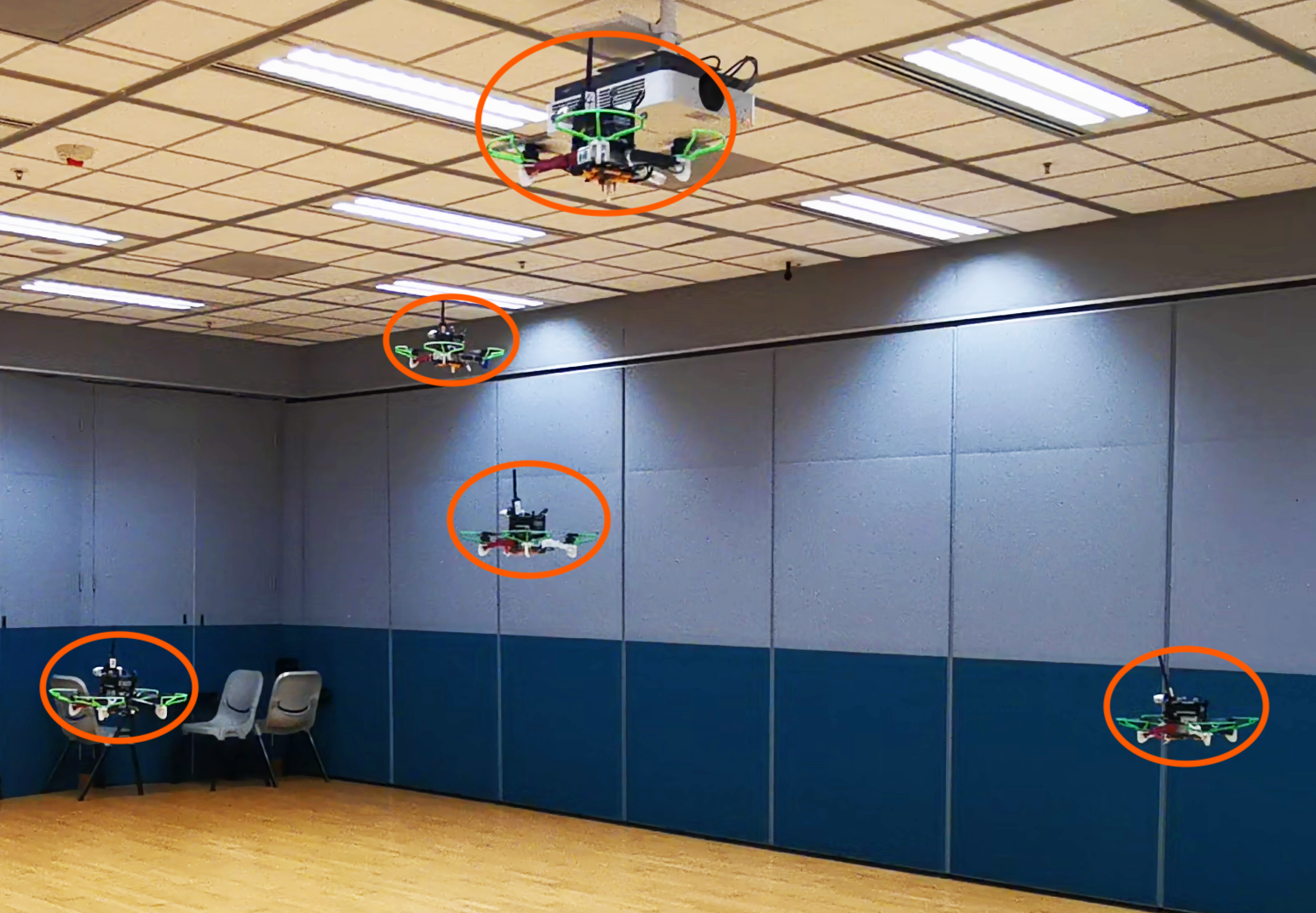
The collaboration of unmanned aerial vehicles (UAVs) has become a popular research topic for its practicability in multiple scenarios. The collaboration of multiple UAVs, which is also known as aerial swarm is a highly complex system, which still lacks a state-of-art decentralized relative state estimation method. In this paper, we present a novel fully decentralized visual-inertial-UWB fusion framework for relative state estimation and demonstrate the practicability by performing extensive aerial swarm flight experiments. The comparison result with ground truth data from the motion capture system shows the centimeter-level precision which outperforms all the Ultra-WideBand (UWB) and even vision based method. The system is not limited by the field of view (FoV) of the camera or Global Positioning System (GPS), meanwhile on account of its estimation consistency, we believe that the proposed relative state estimation framework has the potential to be prevalently adopted by aerial swarm applications in different scenarios in multiple scales.
I Introduction
The collaboration of unmanned aerial vehicles (UAVs) has become a more and more popular research topic in the recent years for its practicability in inspection, search & rescue, and light show performances. Aerial swarm is simply the collaboration of large amount of aerial vehicles. During the collaborative missions, it is crucial to perform real-time state estimation for each drone in order to plan smooth trajectories without collisions. Currently, the state estimations of aerial swarm are widely adopting either Global Positioning System (GPS) based methods[jaimes2008approach]in outdoor environments or motion capture system and Ultra-WideBand (UWB) based methods[alarifi2016ultra] [ledergerber2015robot] [mueller2015fusing] in indoor environments. However, the limitations of these methods are obvious: Due to the constraints of the GPS signal, state estimation for aerial swarm using GPS based methods can only be adopted in outdoor environments. Meanwhile, the system can only provide an accuracy at the magnitude of meters, which is not sufficient for tight formation flying. An alternative method is to increase the accuracy utilizing the Real-Time Kinematic positioning system[moon2016outdoor]. Although the accuracy of centimeter-level positioning can be achieved by making use of the RTK-GPS framework, a ground station is compulsory to manipulate the system, causing the whole system to be clumsy and complicated to operate, which means that the framework can scarcely be adopted in an unknown environment. Despite that motion capture or traditional UWB based localization systems in[alarifi2016ultra] [ledergerber2015robot] [mueller2015fusing] can be functional in the indoor scenarios where the GPS signal is not available, the installation external cameras or ground anchors are still required, which is not suitable for the navigation in unknown environments.
In order to get rid of the bulky external sensors, so as to have the capability of performing swarm flying in unknown environments, adopting a visual-inertial state estimation method[qin2017vins] can be a possible solution, which can provide effective and robust state estimations for UAVs in indoor and outdoor, known and unknown environments. Nevertheless, visual-inertial odometry (VIO) is only capable of providing the state estimations in local frames. Together with the drift issue, it is apparent that a simple one-time alignment of the coordinate systems of the individual UAVs before take-off is not sufficient during formation flying. It is intuitive to perform detection for other vehicles from the images captured by the on-board cameras so as to obtain relative state estimations[saska2017system]. Nonetheless, the estimation of the vehicles that are out of the field of view (FoV) of the on-board cameras can be a tricky problem. Hence, A sensor with omnidirectional sensing range and can be carried by a UAV, like a UWB module, is desired for the state estimation.
As a result, in this paper, we propose a vision-UWB based on-board real-time relative state estimation system which can be adopted in aerial swarm frameworks. The system is
-
1.
Decentralized: Each vehicle perform relative state estimation individually and share information with others;
-
2.
Flexible: Only on-board sensors and computing power, including stereo cameras, inertial measurement units (IMU), UWB modules, as well as DJI Manifold2-Gs are utilized. No external off-board sensors or computing power are required;
-
3.
Robust: The system can handle the lack of the detection results as well as malfunctions of individual vehicles during swarm flights.
Our approach presents a comprehensive solution for on-board relative state estimation, eliminating the environmental restrictions of previous localization methods, which provides other researchers an opportunity to apply aerial swarm motion planning techniques in complex environments.
II Related Works
In recent years, it is shown that researches on aerial swarms are more likely to focus on planning and control, and the relative state estimation is always leaped by adopting external positioning systems, including GPS[jaimes2008approach], motion capture system[preiss2017crazyswarm] or UWB modules with anchers[ledergerber2015robot], which are all centralized system, requiring bulky external devices. There is still no state-of-art solutions for decentralized relative state estimations, which can be adopted on aerial swarm applications. Up to present, there are several proposed solutions or systems but the practicability or the performance are generally not satisfactory. As mentioned previously in Sec. I, it is intuitive to use sensors like camera and UWB modules to perceive relative state estimation and the recent researches generally follows the two branches.
Several works have adopted the UWB based methods for relative localization. In[guo2017ultra][guo2019ultra], the triangulation with distance measurements from the UWB modules are combined with the self displacement from optical flow method to obtain a relative state estimation. Only a 2-D translation is estimated and the initialization requires movement of a drone while other drones keep stationary, which limit the application scenario. In[goel2017distributed], another decentralized system using Extended Kalmen Filter to fuse the information from IMU and relative distance is introduced. The system is claimed to be the first attempt to realize a distributed localization framework with low cost sensors. Nevertheless, there are still large amount of challenges, including the precision problem preserved, making it difficult to put in practice.
A series of work on vision-based relative state estimation has been conducted by M. Saska and his team. In[saska2016auro], a vision based framework is gradually developed. In the system, each drone is equipped with a circle marker for the detection purpose, which can be quite redundant. In [walter2018icuas][walterRAL2019], additional UltraViolet Direction And Ranging (UVDAR) sensor and active marker are installed on the drone for tracking purposes. Nonetheless, all the systems may encounter potential failure or drift when the markers are out of the FoV of the cameras, which limits the application scenario to be leader-follower formation.
III Relative State Estimation Framework
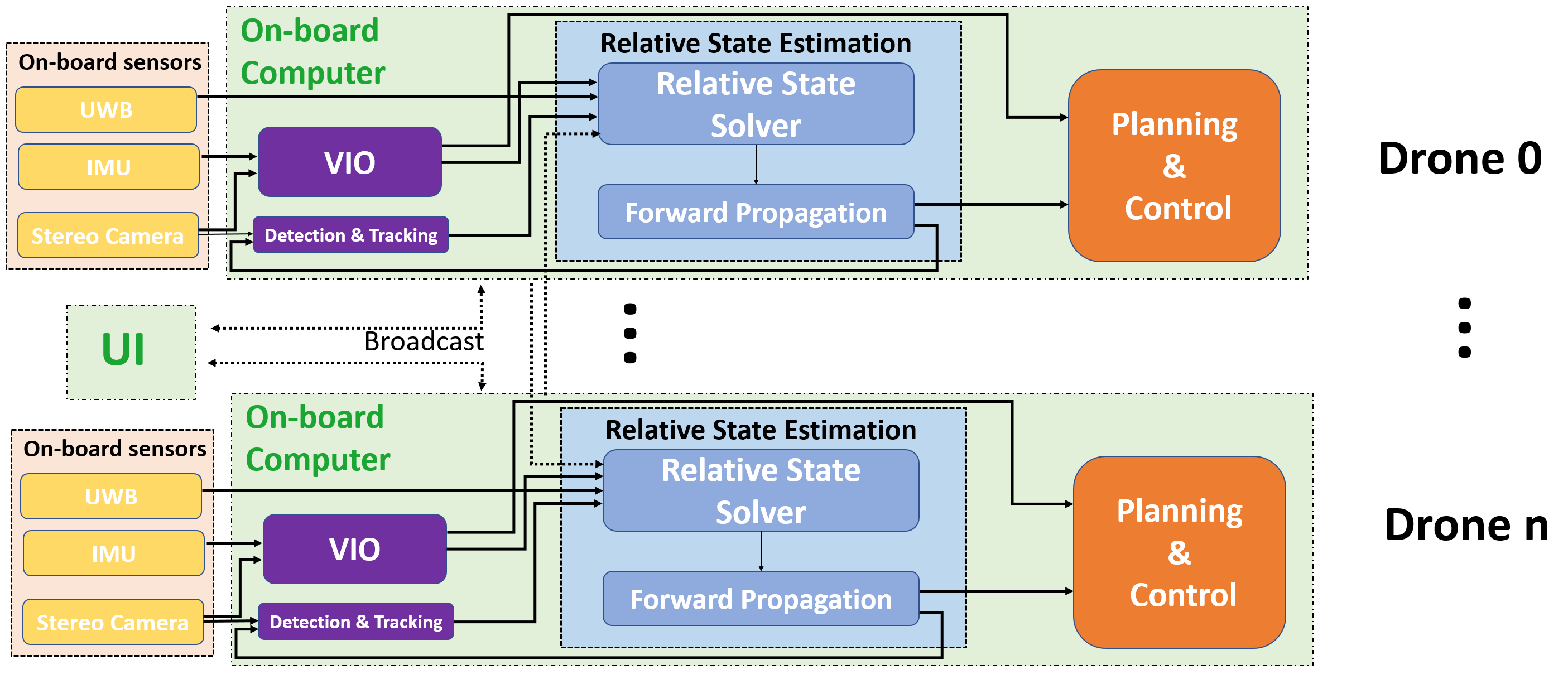
The complete relative state estimation structure is shown in Fig. 2. A combination of a detector and a tracker is adopted for the motion capture of other drones when visible. Meanwhile, the measurements of relative distance from the UWB modules, together with the VIO are incorporated as well to optimize the 4 degrees of freedom (4DoF) relative state estimation, which consists of the three axes of translation , , , and yaw rotation .
We propose a two-stage optimization based relative state estimate for aerial swarm. The first stage is the fusion of visual and inertial data from stereo camera and IMU using VINS-Fusion[qin2017vins]. The second stage is using the VIO result together with detection and UWB relative measurements for optimization-based fusion. The obtained relative state estimations are then sent back to facilitate the detection.
III-A Notations
In order to help to understand the estimation framework, the following notations are defined below and followed by the rest of the paper.