Draft \SetWatermarkScale1 \SetWatermarkLightness0.9
IP Geolocation through Reverse DNS
Abstract.
IP Geolocation databases are widely used in online services to map end user IP addresses to their geographical locations. However, they use proprietary geolocation methods and in some cases they have poor accuracy. We propose a systematic approach to use publicly accessible reverse DNS hostnames for geolocating IP addresses. Our method is designed to be combined with other geolocation data sources. We cast the task as a machine learning problem where for a given hostname, we generate and rank a list of potential location candidates. We evaluate our approach against three state of the art academic baselines and two state of the art commercial IP geolocation databases. We show that our work significantly outperforms the academic baselines, and is complementary and competitive with commercial databases. To aid reproducibility, we open source our entire approach.
1. Introduction
IP Geolocation databases map IP addresses to their corresponding geographical locations. They are often used to find the approximate location of an IP address at the city level. Records in these databases typically contain IP ranges along with their physical location. These databases are vital to a variety of online services when the exact location of a user is not available. Table 1 lists a few examples of such records. For instance, the second example in the table maps a /24 subnet (256 IPs) to Hengyang, a city in China. While some users opt-in to share their exact coordinates to online services through devices with global positioning sensors or Wi-Fi based geolocation, others decline or use devices without such features. IP geolocation is therefore a valuable source of information on user location.
A practical application of IP geolocation is personalized local search results in the context of search engines. Figure 2 demonstrates the striking difference in results for the query ”restaurants” when the user location is unknown, compared to when it is known. The generic nationwide results require the user to requery for more specific restaurants in their area, while the personalized results directly list restaurants tailored to a specific location. Previous work has shown that personalizing results to a user’s location leads to increased user satisfaction and conversely that missing location information leads to user dissatisfaction (Dan et al., 2016; Bennett et al., 2011; Kliman-Silver et al., 2015). IP geolocation databases are also used in many other applications, including: content personalization and online advertising to serve content local to the user (Bennett et al., 2011; Hannak et al., 2013; Kölmel and Alexakis, 2002), content delivery networks to direct users to the closest datacenter (Huang et al., 2011), law enforcement to fight cybercrime (Shue et al., 2013), geographic content licensing to restrict content delivery to licensed geographic regions (MacVittie, 2012), and e-commerce to display variable pricing based on local taxes and shipping (Svantesson, 2007).
| StartIP | EndIP | Country | Region | City |
|---|---|---|---|---|
| 1.0.16.0 | 1.0.16.255 | JP | Tokyo | Tokyo |
| 124.228.150.0 | 124.228.150.255 | CN | Hunan | Hengyang |
| 131.107.147.0 | 131.107.147.255 | US | Washington | Redmond |
Commercial IP geolocation databases such as MaxMind (MaxMind, 2018), Neustar IP Intelligence (Neustar, Inc., 2018), and IP2Location (IP2Location.com, 2018) are considered state of the art. They combine multiple IP location sources, including WHOIS lookups, network latency, network topology, reverse DNS, as well as direct contracts with Internet Service Providers (Muir and Oorschot, 2009). However, the exact methods they use are proprietary. Some of these approaches have been studied in academia to some extent, as described in Section 2. Related work has shown that while they have high coverage, commercial databases are sometimes inaccurate or are missing location information for some IP ranges (Shavitt and Zilberman, 2011; Poese et al., 2011; Gharaibeh et al., 2017).
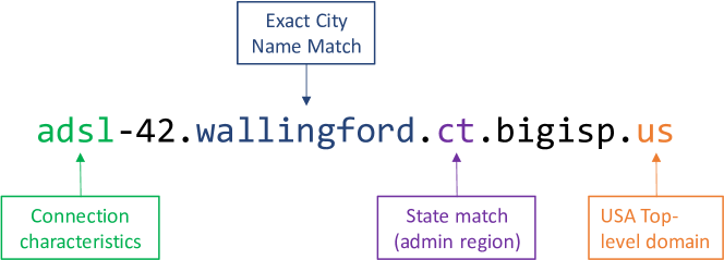
Our work focuses on extracting location information from reverse DNS hostnames assigned to IP addresses, which has many potential advantages including high coverage and accuracy. These hostnames can be periodically collected in a short amount of time by performing a reverse DNS lookup for every address in the IP space. Figure 1 exemplifies the information that can be parsed from reverse DNS hostnames. Here we can derive both the location and connection characteristics for the hostname of an IP address. A person reading the name of the hostname can reasonably determine that it references Wallingford, a town in Connecticut, USA.
Reverse DNS is the opposite of Forward DNS. Forward DNS starts from a domain or subdomain such as www.bing.com and resolves to zero, one, or more IP addresses (Mockapetris, 1987). Note that multiple subdomains can map to the same IP. Conversely, reverse DNS lookups start from an IP address and typically return zero or one hostnames (Eidnes et al., 1998). The reverse DNS hostname does not need to be the same as the Forward DNS hostname. While Forward DNS lookups are used by Internet users to get to websites, Reverse DNS hostnames are typically used to name and describe the underlying physical infrastructure that makes up the Internet.
Figure 3 contains examples of both forward and reverse DNS resolution.

Given a reverse DNS hostname, our task is to determine its location at the city level. This task poses multiple challenges. First, the naming schemes of Internet Service Providers are often ad-hoc and do not always contain the full names or common abbreviations of cities. For example, the drr01.cral.id.frontiernet.net hostname is located in Coeur D’Alene, Idaho. Determining that the cral substring maps to this location is difficult even for a human. Second, many cities around the world have ambiguous names. Take for instance Vancouver, Canada and Vancouver, USA. A hostname which only contains the substring vancouver is not specific enough to determine a single location correctly. Even unambiguous city names can become ambiguous when abbreviations are used instead of their full names. Does nwmd refer to New Richmond, WI or to New Maryland, NB, or to neither of them? Third, sometimes hostnames contain multiple or conflicting locations. For example, it is difficult to determine if sur01.tacoma.wa.seattle.comcast.net is located in Seattle, WA, Tacoma, WA, or maybe even Sumner, WA.
We propose a systematic approach for using reverse DNS hostnames to geolocate IP addresses. Our contributions are:
-
(1)
In our preliminary investigation we determine reverse DNS coverage in the entire IPv4 address space. We also find an upper bound of exact city and airport code matches.
-
(2)
We present a machine learning approach for extracting locations from hostnames. We cast the task as a machine learning problem where for a given hostname, we split the hostname into its constituent terms, we generate a list of potential location candidates, and then we classify each hostname and candidate pair using a binary classifier to determine which candidates are plausible. Finally, we rank the remaining candidates by confidence, and we break the ties by location popularity.
-
(3)
We evaluate our approach against state-of-the-art baselines. Using a large ground truth set, we evaluate our approach against three academic baselines and two commercial IP geolocation databases. We show that our method significantly outperforms academic baselines. We also show that the academic baselines contain incorrect rules which impact their performance. Finally, we demonstrate that our approach is both competitive and complementary to commercial geolocation baselines, which shows that our method can help improve their accuracy.
-
(4)
We release our approach as open source. To help the academic community reproduce our results, we release our reverse DNS geolocation software as open source.
2. Related Work
We divide IP geolocation research in two broad categories, based on the methods they use: network delay and topology approaches use ping, traceroute, and BGP network structure information; web mining approaches use diverse information mined from the web, including WHOIS databases, social graphs, and reverse DNS.
The majority of IP geolocation research relies on active network delay measurements to locate addresses. These approaches issue pings or traceroutes from multiple geographically distributed landmark servers to a target IP, then triangulate the location (Padmanabhan and Subramanian, 2001; Jayant and Katz-Bassett, 2004; Gueye et al., 2006; Katz-Bassett et al., 2006; Youn et al., 2009; Laki et al., 2010; Eriksson et al., 2010; Li et al., 2012; Ciavarrini et al., 2018). Multiple systems such as Octant (Wong et al., 2007), Alidade (Chandrasekaran et al., 2015), or HLOC (Scheitle et al., 2017) combine delay measurement methods with other data sources such as reverse DNS and WHOIS information.
Network delay and topology methods have significant limitations. First, they have scalability issues as they require access to landmark servers distributed around the world and each target IP needs separate measurements. Second, not all networks allow ping and traceroute. Third, routes on the Internet do not necessarily map to geographic distances. These problems often lead to lackluster results, with error distance in the order of hundreds of kilometers (Padmanabhan and Subramanian, 2001; Gueye et al., 2006). Some of the earlier research is also plagued by extremely small ground truth datasets, often focusing on a handful of IP addresses in a few US universities (Padmanabhan and Subramanian, 2001; Katz-Bassett et al., 2006; Gueye et al., 2006; Youn et al., 2009).
Our work addresses several of these limitations. First, using reverse DNS hostnames for geolocation does not require any network delay measurements. Reverse DNS hostnames can be obtained much faster than performing active delay measurements, by querying DNS servers. Second, our ground truth dataset is several orders of magnitude larger than the ones used in previous work and it spans the entire planet. Third, our approach of extracting locations from hostnames can be performed offline. Fourth, our results have lower median error distance than most previous work.
Web mining approaches use diverse information mined from the web. Guo et al. (Guo et al., 2009) extract locations mentioned in web pages and assign the locations to the IPs which host the content. Although they report city level agreement for 87% of the IPs, they use an IP geolocation database with unknown accuracy as ground truth. Endo and Sadok (Endo and Sadok, 2010) propose using whois information. Unfortunately, the evaluation section lacks a comparison against ground truth. Wang et al. (Wang et al., 2011) combine a network delay approach with extracting the location of web servers from the web pages that they host. They obtain a median error of 0.69 kilometers for the best data set, which contains only 88 target IP addresses. Backstrom et al. (Backstrom et al., 2010) propose deriving the location of target users based on the locations of friends. However, this approach requires access to users’ social graphs. It achieves a median error distance of 590 km on 2,830 IPs.
In this work we propose extracting IP locations from their reverse DNS hostnames. GeoTrack (Padmanabhan and Subramanian, 2001), proposed by Padmanabhan and Subramanian, is one of the earliest reverse DNS geolocation approaches. It uses manual rules to determine locations of hostnames in the United States using city names, airport codes, and country codes. It then combines this approach with traceroutes to estimate the location of a target IP. Our machine learning approach does not require manual rules and it achieves a median error of tens of kilometers using a test set of millions of IP addresses.
Undns is the most well-known and widely used reverse DNS geolocation approach (Spring et al., 2002). Similarly to GeoTrack, it consists of manual rules which are expressed as regular expressions at the domain level. For example, the rule ([A-Z]3,4)[0-9]?.verizon-gni.net matches the hostname PHIL.verizon-gni.net. A domain specific location dictionary is then used to match the extracted slot PHIL to Philadelphia, PA. The obvious disadvantage of this approach is that each domain requires manually generated and potentially error prone rules. In comparison, our approach is more scalable since it does not require human generated rules. It also handles unique situations better, since it considers the terms of each hostname individually, without requiring domain-specific training. In Section 6.3 we show that our approach significantly outperforms undns. Multiple geolocation and network topology papers use undns as-is to draw conclusions or perform experiments (Freedman et al., 2005; NUR and TOZAL, 2018). Unfortunately, we demonstrate that undns results suffer due to catch-all rules.
DRoP, another state of the art reverse DNS based approach, aims to geolocate hostnames using automatically generated rules generated by finding patterns across all the hostname terms of a domain (Huffaker et al., 2014). For example, it may find that for the domain cogentco.com, the second term from the right often contains airport codes. These rules are then validated using network delay information. DRoP places 99% of IPs in 5 test domains within 40 km of their actual location. However, it uses network delay measurements, its method of splitting hostnames is rudimentary, and as we show in Section 6.3, it performs poorly on worldwide ISP domains.
Finally DDec (for Applied Internet Data Analysis, 2018) combines undns and DRoP rules by giving precedence to undns and using DRoP as fallback.
3. Datasets
This section contains descriptions of the datasets we use throughout this paper for experiments, training and testing.
Our ground truth set contains 67 million IP addresses with known geographic location. To the best of our knowledge, it is the largest and most diverse set used in geolocation literature. We compiled the ground truth set in March 2018 by randomly sampling the query logs of a large-scale commercial search engine. We describe the characteristics of this dataset in more detail in Section 6.1.
GeoNames is a free database with geographical information (Wick, 2018). The March 2018 snapshot we used contains information on 11.5 million geographic features from all countries in the world. From Geonames we used multiple subsets available separately for download. Cities 1000 consists of information on all cities in the world with a population of at least 1,000, including coordinates, original names, ASCII names, alternate names, and codes of administrative divisions. Alternate Names contains more alternate names for some cities such as abbreviations, colloquial names, and historic names. More importantly, it also contains airport codes issued by IATA, ICAO, and FAAC, which are travel organizations. Admin 1 Codes is comprised of the codes and names of first-level administrative regions. Country Info contains general information about countries, including their Internet top-level domain (TLD).
CLLI is an abbreviation for Common Language Location Identifier. These codes are used by the North American telecommunications industry to designate names of locations and functions of telecommunications equipment. While historically only used by the Bell Telephone companies, they were more recently adopted by other companies as well. Multiple codes can map to the same location. For example, all the following codes map to Chicago, Illinois: chcgil, chchil, chciil, chcjil, and chclil. Note that the codes cannot necessarily be derived from the name of the city. This database is available from multiple sources. We acquired a May 2017 snapshot from TelcoData (Timmins, 2018) for a token amount.
UN/LOCODE, which stands for United Nations Code for Trade and Transport Locations, is a worldwide geographic coding scheme developed and maintained by the UN. It assigns codes to locations used in trade and transport, such as rail yards, sea ports, and airports. The code assigned to Paris, France is FRPAR and the functions listed for this location are: port, rail, road, and postal. This dataset is updated twice a year and it is available for free on the United Nations Economic Commission for Europe website (for Europe, 2018). We used the December 2017 release, which was the latest available version.
Public Suffix List, maintained by the Mozilla Foundation, is a free list of domain suffixes under which Internet users can directly register names (Foundation, 2018). Examples include cloudapp.net and gov.uk.
Rapid7 Reverse DNS consists of reverse DNS hostnames of the entire IPv4 address space. The dataset is available for free and it is updated weekly. The archive contains snapshots going back to 2013 (Rapid7Labs, 2018). We discuss this dataset in detail in the next section.
4. Reverse DNS
Forward DNS lookups convert hostnames such as www.bing.com into IP addresses, while reverse DNS lookups work in the other direction; they start from an IP address and find a hostname. Since the forward and reverse DNS lookups are set in different DNS records, they do not need to have the same hostname. Reverse hostnames are more likely to be used to name the underlying networking infrastructure, while forward hostnames are used to name websites or other online services (Mockapetris, 1987).
IPv6 addresses also have reverse DNS hostnames. The only difference is that the records are under the ip6.arpa domain. While we evaluate our approach on IPv4, all methods described in this paper can be equally applied to IPv6 addresses as well.
To determine the viability of using reverse DNS hostnames for geolocation, we studied the Rapid7 reverse DNS dataset (Rapid7Labs, 2018), which covers the entire IPv4 address space. Rapid7 compiles it by performing IPv4 PTR lookups over the entire address space as described above, except for ranges that are blacklisted or private. The archive contains snapshots going back to 2013 (Rapid7Labs, 2017). This preliminary investigation is based on a snapshot taken in January 2017, while in the rest of the paper we use a more recent dataset from March 2018.
The IPv4 address space consists of all 32-bit numbers. This limits the possible address space to 232 (4.3 billion) addresses. The number of usable IPs is actually only 3.7 billion, since some IP ranges are designated as special-use or private (Internet Assigned Numbers Authority, 2017). Since not all IP addresses have a reverse DNS hostname, we parsed the Rapid7 dataset to find the actual coverage. We found that 1.25 billion addresses have a reverse DNS hostname. This finding shows that although they have significant coverage, these hostnames need to be augmented with other data to obtain a complete geolocation database.
We then quantified how many of the hostnames are valid, since the DNS records are unrestricted strings. We parsed each hostname and rejected the ones that did not respect Internet host naming rules (Braden, 1989). We also rejected hostnames that did not have a valid suffix as defined by the Public Suffix List, which is a list of valid domain suffixes from the Mozilla Foundation previously described in Section 3. This left us with 1.24 billion hostnames, of which 1.15 billion were distinct. Our findings are summarized in Table 2, which shows that 33.4% of usable IP addresses have a valid reverse DNS hostname, and 31.1% are distinct. Considering that not all IPv4 addresses are yet allocated, the actual percentage is likely higher.
Next, we set out to determine if reverse DNS hostnames are a valuable source of geolocation information. We searched for exact city names and airport codes in the hostnames, using the Cities 1000 and the Alternate Names dataset, respectively. We find that 163.7 million hostnames could contain exact city names, and 272.9 million hostnames could contain airport codes. This approach represents an upper-bound of the number of hostnames that could contain exact city names or airport codes. The results contain true positives such as sur01.seattle.wa.seattle.comcast.net in Seattle, Washington and inovea5.gs.par.ivision.fr in Paris, France. However, this naive approach also matches false negatives such as node-j.pool-1-0.dynamic.totbb.net which is not in Pool, UK and mobile.bigredgroup.net.au which is not in Mobile, Alabama. Nevertheless, the results summarized in Table 2 show that there are potentially hundreds of millions of hostnames that could contain geographic information, using just these two features alone. We conclude that while the results are promising, a more sophisticated approach could achieve higher coverage and accuracy.
| Set name | Size | % of usable | % of distinct |
|---|---|---|---|
| Total IPv4 space | 4.3 B | ||
| Reserved IP addresses | 0.6 B | ||
| Usable IP addresses | 3.7 B | ||
| IPs with Reverse DNS hostnames | 1.25 B | 33.7% | |
| Valid Reverse DNS hostnames | 1.24 B | 33.4% | |
| Distinct DNS hostnames | 1.15 B | 31.1% | |
| Exact city match (naive) | 0.16 B | 4.4% | 14.1% |
| Airport code match (naive) | 0.27 B | 7.4% | 23.5% |
| Domain | Count | % of valid | Top hostname components sorted in descending order by how often they appear in all hostnames of this domain |
|---|---|---|---|
| comcast.net | 50.0M | 4.0% | c, hsd, hsd1, m, ca, pa, fl, il, ma, ga, a, co, mi, d, f, wa, b, e, va, nj, or, md, tx, chlm, chic, phil, tn, in, npls, dd, atlt, sjos, denv, mn |
| bbtec.net | 37.2M | 3.0% | softbank, biz |
| rr.com | 31.1M | 2.5% | res, cpe, mta, socal, biz, rrcs, nyc, neo, nc, wi, kya, columbus, cinci, carolina, tx, central, twcny, nycap, west, sw, rochester |
| myvzw.com | 29.6M | 2.4% | sub, qarestr |
| sbcglobal.net | 28.4M | 2.3% | lightspeed, adsl, dsl, irvnca, hstntx, rcsntx, cicril, sntcca, tukrga, miamfl, pltn, pltn13, stlsmo, livnmi, bcvloh, frokca, chcgil |
| t-ipconnect.de | 24.5M | 2.0% | dip, dip0, p, b, e, a, f, d, c, pd, fc, fd, fe, ff, de, dd, dc, df, ee, bb, bd, bc, ae, ac, aa, ab, af, ad, ba, bf, ea, eb, be, ec, fa, ed, fb, ef, db, da, ca, cf |
| telecomitalia.it | 19.4M | 1.6% | host, static, business, b, r, retail, dynamic, host156, host15, host94, host61, host127, host232, host112, host95, host72, host107, host220 |
| ge.com | 16.7M | 1.4% | static, n, n003, n003-000-000-000, n129, n144, n144-220-000-000, n129-201-000-000, n129-202-000-000, n165-156-000-000m n165, n192 |
| ocn.ne.jp | 16.2M | 1.3% | p, ipngn, tokyo, osaka, ipbf, marunouchi, ipbfp, omed, omed01, kanagawa, hodogaya, aichi, osakachuo, saitama, hokkaido |
| spcsdns.net | 16.0M | 1.3% | pools, static |
To further familiarize ourselves with hostname naming conventions, we extracted the top hostname components of the largest 10 domains in the Rapid7 dataset. We divided each subdomain on the dotted terms, and then we further split the components on dashes and on the transitions between numbers and letters. For example, we split soc-l.wht2.ocn.ne.jp into soc, l, wht. We then manually labeled the components that we found to reasonably correspond to geographic locations. We also cross-checked our findings with commercial geolocation databases. Table 3 shows a sumary of the results. We observe that only 4 out of the top 10 domains contain indicators of geographic location. However, those that use geographic encodings do so extensively. We found that service providers use various naming conventions across different networks and within a single network. For instance, the hostnames under the sbcglobal.net domain owned by AT&T make use of abbreviations such as pltn to refer to Pleasanton, CA. But they also use combinations of city abbreviations with State names such as chcgil to refer to Chicago, Illinois. Our findings are in line with previous work by Chabarek and Barford (Chabarek and Barford, 2013). They found that all 8 of the providers they studied used multiple naming schemes. They also found that 20 out of 22 North American providers they surveyed use geographic encodings in their hostnames.
We also studied the distribution of top-level domains (TLDs) such as .com and .fr in the Rapid7 dataset to determine if country-specific domains can be used as location hints. We observed that most hostnames contain a .net domain at 33.2%, followed by .com with only 17.2%. This is the opposite of forward DNS, where .com is more popular. The difference is due to Internet Service Providers preferring to use .net domains for hostnames that describe the underlying physical architecture of their network. After removing the .com, .net, .edu, and .mil domains which together make up 51.6% of valid hostnames, we are left with approximately 600 million hostnames, the vast majority of which are country-specific. We found very few novelty TLDs used in reverse DNS hostnames. We conclude that the corresponding country of a reverse DNS domain could potentially be a useful hint in geolocation.
Finally, we compared snapshots of the dataset, each collected in the month of January of years 2014 to 2017, inclusive. Our goal was to determine how the characteristics of the hostnames change in time. For each IP in the snapshot we compared the hostname values in consecutive years. Table 4 shows a summary of the results. We found that a maximum of 14.7% of hostnames changed year over year and 63.7% of them remain the same across all four years. These numbers include the cases where one side of the comparison had a hostname but the other side was empty due to the DNS query returning an empty hostname, or due to the request failing because of network failures during data collection. We then performed a similar comparison, this time counting only the cases where both sides of the comparison contained non-empty hostnames. Here we found that a maximum of 2.2% hostnames change over the years, if both the values are present. To understand why there is such a large discrepancy between these two findings we also determined the number of hosts that were gained or list between the years. By hostnames gained we mean that in the older year a hostname was missing, while in the subsequent year it was present, and by hostnames lost we mean the opposite. The results show that yearly more hostnames are gained than lost, at about a ratio of 2:1.
In summary, we determined that 1.24 billion IP addresses have valid reverse DNS hostnames with 1.15 billion distinct values, many of which contain exact city or airport code matches.
| Change / Year Pair | 2014 →2015 | 2015 →2016 | 2016 →2017 |
|---|---|---|---|
| Hostnames changed (incl. empty) | 179M (14.7%) | 159.3M (12.6%) | 164.8M (12.8%) |
| Hostnames changed (non-empty) | 26.4M (2.2%) | 20.7M (1.6%) | 14.2M (1.1%) |
| Hostnames gained | 108.5M (8.9%) | 89.3M (7.1%) | 81M (6.3%) |
| Hostnames lost | 44M (3.6%) | 49.4M (3.9%) | 70M (5.4%) |
5. Approach
We cast the problem of extracting locations from reverse DNS hostnames as a machine learning problem. We train a binary classifier on a dataset where each training sample is a hostname and location candidate pair, along with a binary label which signifies if the hostname is likely or unlikely to be in the candidate location. Given a new hostname, our proposed approach splits the hostname into components, finds a preliminary list of location candidates, generates primary and secondary features for each candidate, then classifies each potential location using the classifier, also assigning each candidate a confidence score. For instance, for the hostname ce-salmor0w03w.cpe.or.portland.bigisp.net our approach considers tens of potential location candidates, including Portland, UK and Salmoral, Spain. In the end however, it ranks Salem, Oregon and Portland, Oregon as the most likely candidates.
5.1. Splitting hostnames
Drawing from our preliminary analysis in Section 4, as well as further manual analysis, we implemented multiple heuristics for splitting hostnames into their constituent components.
First, we apply the ToUnicode algorithm described in RFC3490 (P. Faltstrom, 2003) to convert International Domain Names (IDN) to Unicode. The reason we perform this translation is that international hostnames are stored as ASCII strings using Punycode transcription. For example, the hostname xn--0rsod70av79j.xn--j6w193g gets converted to 夏威夷舞.香港. This allows us to perform location lookups using the original language of the hostname.
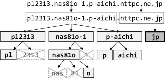
Second, we separate the subdomain from the domain and the public suffix, using the list provided by the Mozilla Foundation previously described in Section 3. These suffixes are a superset of normal TLDs because they also contain entire domains under which users can create subdomains. For example, the list contains the pseudo-TLD azurewebsites.net since users of Azure cloud services can register their own subdomains under this name. At this point we also extract the native TLD. For instance, for dps8099.denver.k12.co.us we extract denver.k12.co.us as the domain because k12.co.us is a public suffix, we extract dps8099 as the subdomain, and finally we extract .us as the TLD.
Third, we split the extracted subdomain at three levels of aggregation: on the dotted elements, on hyphens within the dotted elements, and on the transitions between letters and numbers within the hyphenated elements, saving the results at each level. Figure 4 contains a specific example represented intuitively as a tree structure. The bottom three levels of the tree correspond to the three levels of aggregation. As a last step, we trim the leaf nodes. We remove any leaf node consisting solely of numbers. We also remove common terms terms related to connection characteristics, such as dsl, fiber, and nas. We obtained them by counting the top extracted leaf nodes in the training set and manually selecting the ones which are unrelated to geolocation but clearly related to the underlying network infrastructure. The list is available in the source code we are publishing along with this paper.
5.2. Features
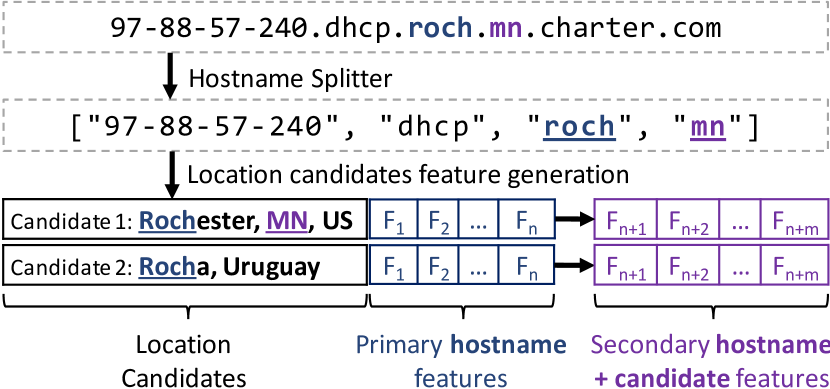
Starting from the results of the hostname splitter, we find the location candidates along with their primary and secondary features, as defined below. The list of preliminary location candidates is defined by the union of locations which match any of the primary features of the hostname. Figure 5 shows a concrete example. Primary features can be derived directly from a hostname. These features are matched using a single contiguous string which indicate a location at city level granularity. Primary feature generation and candidate selection happen at the same time. Secondary features are generated in the context of a hostname and location candidate pair. These features require the context of a primary candidate to match. In our example two location candidates and their primary features are first selected based on the term roch in the hostname. Then we compute secondary features separately for each candidate. In the context of Rochester, Minnesota, we match the mn term as a secondary feature that captures the administrative region for this candidate.
Primary features are based on the GeoNames, UN/LOCODE, and CLLI datasets described in Section 3. From GeoNames we use the Cities 1000, Alternate Names, and Admin 1 Codes subsets. The primary feature categories are listed in Table 5. Each of these categories is represented by three specific features: IsMatch, Population, and MatchedLettersCount. The IsMatch feature is a boolean which indicates if the feature matched the current hostname and current location candidate. The Population feature contains the population of the current location, if IsMatch is true. We use population as a proxy for the importance of a city candidate. Finally, MatchedLettersCount contains the number of characters which matched. As the number of characters in common between a hostname and a location increases, it could mean a higher confidence match. For instance, if the hostname contains the letters seattle and the current location candidate is Seattle, Washington, then the CityName-MatchedLettersCount Feature would have a value of seven.
| Category | Example | Location |
|---|---|---|
| City Name | p907072-li-mobac01.osaka.ocn.ne.jp | Osaka, JP |
| Alternate names | 178235248188.warszawa.vectranet.pl | Warsaw, PL |
| Abbreviations | cpe-68-173-83-248.nyc.res.rr.com | New York City |
| City + Admin1 | torontoon-rta-1.inhouse.compuserve.com | Toronto, ON |
| City + Country | er1-ge-7-1.londonuk5.savvis.net | London, UK |
| No Vowels Name | static-50-47-60-130.sttl.wa.frontiernet.net | Seattle, WA |
| First Letters | 97-90-205-107.dhcp.losa.ca.charter.com | Los Angeles |
| Airport Code | 62.80.122.50.fra.de.eunx.net | Frankfurt, DE |
| CLLI Code | 99-166-111-251.tukrga.sbcglobal.net | Tucker, GA |
| UN/LOCODE | 16.151.88.129,krsel19d.kor.hp.com | Korea, Seoul |
| Host Patterns | atoulon-651-1-29-109.abo.wanadoo.fr | Toulon, FR |
| Category | Candidate | Match Example |
|---|---|---|
| Admin1 | Johnstown, PA | 138-207-246-119.jst.pa.atlanticbb.net |
| First Letters Admin 1 | Ft. Huachuca, AZ | frth-bw-noc.ariz.aisco.ngb.army.mil |
| Country | Paris, FR | ci77.paris12eme.fr.psi.net |
| Country TLD | Barcelona, ES | barcelona.fib.upc.es |
While most feature categories in Table 5 are self-explanatory, we describe them here briefly. The City Name category matches entire names of cities. Alternate names matches translations and colloquial names of locations. Abbreviations are based on the first letters of cities with longer names, such as sf for San Francisco. The City + Admin1 category consists of concatenations of city and administrative regions, such as seattlewa. Similarly, City + Country matches combinations of city and country names.
The intent of the No Vowel Name feature is to match city names without vowels. It allows partial matches using the first 3 or more letters of the names. For example, this allows matching gnvl to Greenville, SC and rvrs to Riverside, CA. Furthermore, based on our observations we extended this feature with more complex variations. We select the first and last letters of each word in the name, even if the letters are vowels. We then generate combinations of letters from this list, in order. Examples matched by this variation include oxfr for Oxford, MA, and ftmy for Fort Meyers, FL.
The First Letters features use the first consecutive letters of locations. The Airport Code category spans airport codes from travel organizations. CLLI and UN/LOCODE codes match telecommunications and transportation codes of locations, respectively.
Finally, Host Patterns attempts to capture rules not encompassed by the other features. Using training data we extract frequently co-occurring hostname term permutations of one or two terms. We then aggregate the training data per domain and within a domain on the term permutations. If at least 40% of the training locations for a permutation are located within a 20 kilometer radius, we convert the term permutation into a rule. We determined the support ratio and the distance radius using a small validation set. For example, this feature determines that whenever a hostname in the frontiernet.net domain contains the term or in the rightmost position and the term mmvl in the second rightmost position, then the hostname is most likely located in McMinnville, Oregon. This feature would then match for the hostname static-50-126-80-6.mmvl.or.frontiernet.net.
Secondary features are determined in the context of a hostname and location candidate pair. As shown in Figure 5, we first determine all candidates before we can compute the secondary features. An example of secondary features for the Rochester, MN candidate is Admin1 Match, which is true only if the administrative region of the candidate location can be found in a different term of the hostname. Since the hostname contains the term mn, which is an abbreviation of Minnesota, then this secondary feature is true for the first candidate. However, it is false for the second candidate, because Rocha is in an administrative region also called Rocha, and it cannot be found in the hostname. First Letters Admin 1 is similar, but it matches at least 3 first consecutive letters of administrative names. Country and Country TLD both try to match the country of the current candidate by searching for a country code in the hostname terms or in the domain TLD, respectively.
5.3. Classifier
For a given hostname, our reverse DNS geolocation can extract and evaluate tens of potential location candidates. For example, if one of the terms of the hostname is york, the initial list of candidates will contain all locations named York in the world. We run a binary classifier on each of the initial candidates. The classifier uses the primary and secondary features to evaluate if it is plausible for the hostname to be located in a candidate location. All the candidates where the classifier returns false are discarded. The remaining plausible candidates are sorted by confidence and returned in a list.
Although determining the optimal type of binary classifier is outside of the scope of this work, we tested four variations of the classifier: logistic regression, C4.5 decision trees, random forest, and SVM. Logistic regression had the best performance on a small validation set. Consequently, we performed all experiments in Section 6 using this classifier.
5.4. Sampling Strategy
We propose sampling the training set to account for data bias, to improve generalization, and to reduce the amount of required training data. First, the entire set of reverse DNS hostnames is naturally skewed towards the largest Internet Service Providers, which own the most addresses. Second, some feature categories such as City Name occur much more often than others such as Abbreviations. This can lead the classifier to ignore less frequent features categories. Third, during training multiple location candidates can be generated for each hostname, out of which at most one can be correct. Since the classifier is trained on hostname and candidate pairs, this also introduces another type of bias where the number of negative samples significantly outweighs the number of positive ones. Therefore, we sample data to account for some of this bias and to improve generalization through increased training data diversity.
We perform stratified sampling on the domain of the hostname, keeping at most samples per domain. This approach ensures that naming schemes of large organizations do not significantly skew the training data. We further increase feature diversity by keeping a ratio of between the number of samples that contain the most commonly occurring feature and the ones that contain the least occurring feature. Finally, we also enforce a ratio of between the number of negative and positive examples. We evaluate our data sampling strategy and its three parameters in Section 6.2.
6. Evaluation
We evaluate our approach against three state-of-the-art academic baselines and two commercial geolocation databases. We show that our method significantly outperforms academic baselines and is complementary and competitive to commercial databases.
6.1. Ground Truth
Our ground truth dataset contains 67 million IP addresses with known IP location, of which we used 40 million for training and 27 million for testing. We compiled the dataset in March 2018 from a subset of the query log of a major search engine. Each IP address has a corresponding location obtained from users that opted in to provide their location through devices connected to cellular networks or home Wi-Fi networks. We discarded any IP address that was present in multiple cities over the course of a month. The locations were aggregated at IP and city level by an automated pipeline. We did not have access to the locations of individual users.
6.2. Preliminary Evaluation
We conducted two experiments to evaluate the binary classifier in isolation. In the first experiment, we randomly selected 100,000 IP addresses from the training set and performed ten-fold cross validation. We did not further sample the data in any other way. For each hostname, we extracted location candidates, then ran the binary classifier on all the pairs between the target hostname and each of its candidates. Since our approach can return multiple plausible locations for a given hostname, we choose the candidate with the highest classifier confidence. We break ties by selecting the location with the highest population, as a proxy of popularity. We obtained an overall accuracy of 99%, mostly because the vast majority of results were true negatives. However, the true positive rate was only 67.6%, precision was 80.9%, and recall was 67.6%.
In the second experiment we introduced training data sampling as described in Section 5.4. We set the , , and parameters to 200, 10, and 3, respectively. We again performed ten-fold cross validation. Although accuracy decreased to 92.9%, we obtained better results for true positive rate, precision, and recall, at 78.8%, 88.5%, and 78.8%, respectively. We varied the values of the , , and parameters using exhaustive search but this did not alter the results significantly. In conclusion, our sampling strategy helps the classifier generalize and it significantly improves results.
6.3. Academic baselines
| Metric → | Median Error in km (lower is better) | RMSE based on km (lower is better) | Coverage (higher is better) | Combined score (higher is better) | |||||||||||||
|---|---|---|---|---|---|---|---|---|---|---|---|---|---|---|---|---|---|
| Domain ↓ | # | undns | DRoP | DDec | RDNS | undns | DRoP | DDec | RDNS | undns | DRoP | DDec | RDNS | undns | DRoP | DDec | RDNS |
| 163data.com.cn | 166K | 1,517.5 | N/A | 1,517.5 | 10.6 | 1,495 | N/A | 1,495 | 404 | 100% | N/A | 100% | 94.5% | 0.67 | N/A | 0.67 | 2.34 |
| bell.ca | 200K | N/A | 5,875.2 | 5,875.2 | 6.0 | N/A | 5,807 | 5,807 | 1,262 | N/A | 2.3% | 2.3% | 95.7% | N/A | 0.00 | 0.00 | 0.76 |
| brasiltelecom.net.br | 32K | 808.7 | 5,628.7 | 808.7 | 15.2 | 889 | 5,620 | 889 | 427 | 100% | 69.7% | 100% | 73.9% | 1.12 | 0.12 | 1.12 | 1.73 |
| charter.com | 580K | 60.8 | N/A | 60.8 | 59.9 | 478 | N/A | 478 | 484 | 78.0% | N/A | 78.0% | 89.0% | 1.63 | N/A | 1.63 | 1.84 |
| frontiernet.net | 67K | 36.5 | 6,247.6 | 36.5 | 16.7 | 785 | 6,101 | 785 | 689 | 3.6% | 0.8% | 3.6% | 99.4% | 0.05 | 0.00 | 0.05 | 1.44 |
| nttpc.ne.jp | 0.9K | 9.5 | 9,259.9 | 16.2 | 9.1 | 2,081 | 9,161 | 4,976 | 3,694 | 12.0% | 16.2% | 16.2% | 57.6% | 0.06 | 0.02 | 0.03 | 0.16 |
| optusnet.com.au | 100K | 704.4 | 16,134.6 | 704.4 | 12.7 | 1,175 | 16,374 | 1,175 | 583 | 100% | 49.8% | 100% | 98.9% | 0.85 | 0.03 | 0.85 | 1.70 |
| qwest.net | 408K | 3,426.6 | 8,038.7 | 8,038.7 | 17.6 | 6,856 | 7,361 | 7,361 | 427 | 0.0% | 4.1% | 4.1% | 94.0% | 0.00 | 0.01 | 0.01 | 2.20 |
| Overall | 1.6M | 163.9 | 13,974.2 | 177.9 | 17.5 | 924.0 | 12,640.4 | 1,497.5 | 677.8 | 48.3% | 6.1% | 49.7% | 92.3% | 0.52 | 0.00 | 0.33 | 1.36 |
| Hostname | Location extracted incorrectly by DRoP | Correct location | DRoP Rule |
|---|---|---|---|
%<<pop>>([^L]+L+D*)3.bell.ca| \\
\texttt{200-96-182-198.cbace700.\boldunder{dsl}.brasiltelecom.net.br} & \textbf{dsl} → Daru, Sierra Leone & \textbf{cbace}, \textbf{.br} → Cuiabá, Brazil & \texttt{\%\verb¡¡iata¿¿.brasiltelecom.net.br—
|
|||
%<<pop>>([^L]+L+D*)2.frontiernet.net| \\
\texttt{st0120.\boldunder{nas}931.m-hiroshima.nttpc.ne.jp} & \textbf{nas} → Nassau, Bahamas & \textbf{hiroshima}, \textbf{.jp} → Hiroshima, Japan & \texttt{\%\verb¡¡iata¿¿([^L]+L+D*)2.nttpc.ne.jp—
|
|||
%<<iata>>.optusnet.com.au| \\
\texttt{71-209-14-48.\boldunder{bois}.qwest.net} & \textbf{bois} → ’s-Hertogenbosch, The Netherlands & \textbf{bois} → Boise, Idaho, USA & \texttt{\%\verb¡¡pop¿¿.qwest.net—
|
|||
We next evaluate against three state-of-the-art academic baselines. Like our approach, they receive a hostname as input and attempt to extract its location. The undns baseline from University of Washington consists of manually generated rules that map hostname patterns to locations (Spring et al., 2002). The DRoP baseline from CAIDA at University of California-San Diego relies on automatically generated rules derived from hostname patterns and validated by active measurement data (traceroutes) (Huffaker et al., 2014). Finally, the DDec baseline also from CAIDA combines the results from undns and DRoP (for Applied Internet Data Analysis, 2018).
Since all three baselines are accessed from a public web endpoint (for Applied Internet Data Analysis, 2018), we had to restrict the number of requests we made to a manageable size, out of politeness. For testing we initially selected multiple service providers of different sizes, spanning various countries around the world. However, the baselines were missing any rules for several of these providers, including airtelbroadband.in from India, bigpond.net.au from Australia, and megared.net.mx in Mexico. Although the baselines have good rule coverage in North America, they are at least partially lacking in international coverage. In the interest of fairness, we selected a list of eight providers, each of which are covered by at least two of the baselines.
To train the classifier, our sampling strategy only considered approximately 60,000 data points out of the 40 million hostnames in our training set. From our test set of 27 million IP addresses, we selected all of the ground truth data points which intersected the eight target providers, which yielded a testing subset of 1.6 million hostnames. We issued these requests to the CAIDA web endpoint and parsed the responses from each of the baselines.
Table 7 lists the results for each of the eight domains, as well as the overall results across the entire testing subset. Our approach is labeled RDNS in the table. We define the error distance in kilometers to be the distance between where a model places the location of a hostname, and the actual location of the IP address behind that hostname. The first block of results shows median error distance in kilometers. We observe that our model significantly outperforms the baselines and its results are generally more stable across all domains. We also observe that the median error distance for several domains is abnormally high for the DRoP baseline, and sometimes for the other baselines as well. To further investigate this surprising finding we manually verified a small sample of results. Table 8 lists examples of locations extracted incorrectly by the DRoP baseline. In the last column of the table we list the rule that caused the incorrect extraction. For example, DRoP incorrectly determines that the hostname d49-194-53-51.meb1.vic.optusnet.com.au is in Vicenza, Italy, using the rule %<<iata>>.optusnet.com.au. Although the IATA airport code vic is indeed located in Vicenza, the correct location is Melbourne, Victoria. We could not find any optusnet.com.au hostname where the rule was correct. In conclusion, the DRoP baseline contains incorrect rules for some domains. The results for the undns baseline also indicate high error distance for multiple test domains. After investigating the results, we found that undns sometimes maps entire TLDs to a single city. For example, the locations for all 163.data.com.cn hostnames are extracted as Beijing, China. Lastly, since DDec is a combination of undns and DRoP, it is also affected by incorrect rules.
The advantage of using median as a metric is that it is impervious to outliers, which can favor our model that can place false positives far from the actual location, generating larger outliers. To fairly characterize the results, we also computed RMSE, a metric at the other extreme of the spectrum. RMSE, which stands for root mean squared error, easily gets swayed by large outliers. This poses a disadvantage for our model. We compute it using the error distance in kilometers for each hostname. The RMSE results in Table 7 show that generally our approach still outperforms the baselines in 6 out of 8 domains. In the two cases where our model has higher RMSE than the models, the coverage of our model is higher.
In 3 out of 8 cases the undns baseline has 100% coverage. We define coverage as the total number of hostnames where a model made a decision, over the total number of hostnames in the test set. undns having high coverage is a side effect of it using catch-all rules that map entire TLDs to a single city. In all three cases this leads to poor results for both median error and RMSE.
We define the combined score as the inverse of RMSE multiplied by coverage. As error distance improves (gets smaller), the combined score increases, and vice versa. Similarly, higher coverage also improves the combined score, and vice versa. Our approach significantly outperforms all academic baselines when considering the combination of error distance and coverage.
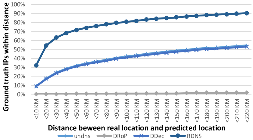
Finally, Figure 6 displays the cumulative error distance in kilometers. The X axis represents the maximum distance between the real location and the predicted location. The Y axis shows how many hostnames and their IP addresses fall within the error distance. For instance, the ¡20 km column shows that our method, labeled RDNS, places approximately 54% of hostnames in the ground truth set within 20 kilometers of their actual location. Our method outperforms the baselines by a large margin. The DRoP baseline yields the worst results, significantly underperforming the other methods.
6.4. Commercial baselines
In this work we focus on improving reverse DNS geolocation, which is only one source of geolocation information. Table 2 reveals that about a third of IP addresses have reverse DNS hostnames. A further subset of these hostnames contain location hints. While this can result in hundreds of millions of hostnames with location information, this is insufficient to completely cover the IPv4 space.
Commercial geolocation databases combine and conflate multiple geolocation data sources. Information from reverse DNS hostnames is required but not sufficient to compile a full geolocation database. Our approach, which can output multiple potentially valid location candidates for a given hostname, lends itself to being combined with other data source to form a more complete database.
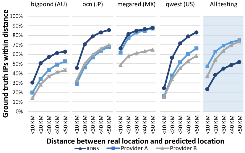
Although reverse DNS geolocation on its own cannot match commercial databases, we evaluate our approach to show that our approach can complement and potentially improve existing databases. We trained our classifier as described in Section 6.3. We then obtained two state of the art commercial IP geolocation databases. We tested our approach against the two commercial database providers A and B using our entire test dataset of 27 million hostnames. The first four graphs in Figure 7 show that on certain domains our approach outperforms, and thus can be used to improve, commercial databases. However, as expected, the fifth graph shows that overall the commercial databases still outperform our method. Results show that median error is 43.7, 16.7, 11.1 kilometers, and RMSE is 4649, 545.3, 545.9 for RDNS, Provider A, and Provider B, respectively.
7. Privacy
Online privacy is becoming increasingly important. For example, Pew research has found in 2016 that while many Americans are willing to share personal information in exchange for accessing online services, they are often cautious about disclosing their information and frequently unhappy about what happens to that information once companies have collected it (Rainie and Duggan, 2016). We have designed both our approach and our evaluation with this sensitive subject in mind.
Our proposed geolocation method relies on reverse DNS hostnames shared publicly by Internet Service Providers. These hostnames provide only coarse city-level or region level location information. Therefore our approach may be more privacy conscious than the widespread industry practice of requesting exact GPS coordinates through mobile apps or the HTML5 Geolocation API.
Furthermore, the ground truth set was anonymized before we had access to it by modifying raw locations in a random direction by 200 meters, aggregating all locations reported for an IP address, and reducing location accuracy to city-level.
8. Reproducing Results
To aid in reproducing and extending our results, we are open sourcing all the major components of our approach, including the hostname splitter and the terms blacklist, our sampling strategy, the primary and secondary feature generators, as well as the classifier itself. For feature generation we have purposely used mainly freely available datasets as described in Section 3. While we cannot include our ground truth set because it is proprietary, we will make available a binary version of our model. We will also publish instructions on creating a ground truth set using public datasets by using our sampling strategy to minimize any manual labeling.
9. Conclusions and Future Work
We presented a machine learning approach to geolocating reverse DNS hostnames. Our method significantly outperforms several state of the art academic baselines and it is competitive and complementary with commercial baselines. Our method outputs multiple plausible locations in case of ambiguity. It thus lends itself to being combined with other data sources to form a more complete geolocation database. Our future work will focus on combining reverse DNS hostname information with WHOIS databases and network delay to form a geolocation database across the entire IP space.
References
- (1)
- Backstrom et al. (2010) Lars Backstrom, Eric Sun, and Cameron Marlow. 2010. Find Me if You Can: Improving Geographical Prediction with Social and Spatial Proximity. In WWW 2010. ACM, Raleigh, North Carolina, USA, 61–70. https://doi.org/10.1145/1772690.1772698
- Bennett et al. (2011) Paul N. Bennett, Filip Radlinski, Ryen W. White, and Emine Yilmaz. 2011. Inferring and Using Location Metadata to Personalize Web Search. In SIGIR 2011. ACM, Beijing, China, 135–144. https://doi.org/10.1145/2009916.2009938
- Braden (1989) R. Braden. 1989. Requirements for Internet Hosts – Application and Support. RFC 1123. RFC Editor. https://tools.ietf.org/html/rfc1123
- Chabarek and Barford (2013) Joseph Chabarek and Paul Barford. 2013. What’s in a name?: decoding router interface names. In Proceedings of the 5th ACM workshop on HotPlanet. ACM, 3–8.
- Chandrasekaran et al. (2015) Balakrishnan Chandrasekaran, Mingru Bai, Michael Schoenfield, Arthur Berger, Nicole Caruso, George Economou, Stephen Gilliss, Bruce Maggs, Kyle Moses, David Duff, et al. 2015. Alidade: IP geolocation without active probing. Technical Report. Department of Computer Science, Duke University.
- Ciavarrini et al. (2018) Gloria Ciavarrini, Maria S Greco, and Alessio Vecchio. 2018. Geolocation of Internet hosts: Accuracy limits through Cramér–Rao lower bound. Computer Networks 135 (2018), 70–80.
- Dan et al. (2016) Ovidiu Dan, Vaibhav Parikh, and Brian D Davison. 2016. Improving IP geolocation using query logs. In Proceedings of the Ninth ACM International Conference on Web Search and Data Mining. ACM, 347–356.
- Eidnes et al. (1998) H. Eidnes, G. de Groot, and P. Vixie. 1998. Classless IN-ADDR.ARPA delegation. RFC 2317. RFC Editor. https://tools.ietf.org/html/rfc2317
- Endo and Sadok (2010) P.T. Endo and D. Sadok. 2010. Whois Based Geolocation: A Strategy to Geolocate Internet Hosts. In AINA 2010. 408–413. https://doi.org/10.1109/AINA.2010.39
- Eriksson et al. (2010) Brian Eriksson, Paul Barford, Joel Sommers, and Robert Nowak. 2010. A learning-based approach for IP geolocation. In International Conference on Passive and Active Network Measurement. Springer, 171–180.
- for Applied Internet Data Analysis (2018) Center for Applied Internet Data Analysis. 2018. DDec - DNS Decoded - CAIDA’s public DNS Decoding database. (2018). http://ddec.caida.org/help.pl Accessed: 2018-07-31.
- for Europe (2018) United Nations Economic Commission for Europe. 2018. UN/LOCODE: United Nations Code for Trade and Transport Locations. (2018). https://www.unece.org/cefact/locode/welcome.html Accessed: 2018-06-27.
- Foundation (2018) Mozilla Foundation. 2018. Public Suffix List. (2018). https://publicsuffix.org/list/ Accessed: 2018-06-28.
- Freedman et al. (2005) Michael J Freedman, Mythili Vutukuru, Nick Feamster, and Hari Balakrishnan. 2005. Geographic locality of IP prefixes. In Proceedings of the 5th ACM SIGCOMM conference on Internet Measurement. USENIX Association, 13–13.
- Gharaibeh et al. (2017) Manaf Gharaibeh, Anant Shah, Bradley Huffaker, Han Zhang, Roya Ensafi, and Christos Papadopoulos. 2017. A look at router geolocation in public and commercial databases. In Proceedings of the 2017 Internet Measurement Conference. ACM, 463–469.
- Gueye et al. (2006) Bamba Gueye, Artur Ziviani, Mark Crovella, and Serge Fdida. 2006. Constraint-Based Geolocation of Internet Hosts. IEEE/ACM Transactions on Networking 14, 6 (Dec 2006), 1219–1232. https://doi.org/10.1109/TNET.2006.886332
- Guo et al. (2009) Chuanxiong Guo, Yunxin Liu, Wenchao Shen, H.J. Wang, Qing Yu, and Yongguang Zhang. 2009. Mining the Web and the Internet for Accurate IP Address Geolocations. In INFOCOM 2009. 2841–2845. https://doi.org/10.1109/INFCOM.2009.5062243
- Hannak et al. (2013) Aniko Hannak, Piotr Sapiezynski, Arash Molavi Kakhki, Balachander Krishnamurthy, David Lazer, Alan Mislove, and Christo Wilson. 2013. Measuring personalization of web search. In Proceedings of the 22nd international conference on World Wide Web. ACM, 527–538.
- Huang et al. (2011) Cheng Huang, D.A. Maltz, Jin Li, and Albert Greenberg. 2011. Public DNS system and Global Traffic Management. In INFOCOM 2011. 2615–2623. https://doi.org/10.1109/INFCOM.2011.5935088
- Huffaker et al. (2014) B. Huffaker, M. Fomenkov, and k. claffy. 2014. DRoP:DNS-based Router Positioning. ACM SIGCOMM Computer Communication Review (CCR) 44, 3 (Jul 2014), 6–13.
- Internet Assigned Numbers Authority (2017) Internet Assigned Numbers Authority. 2017. IANA IPv4 Special-Purpose Address Registry. Technical Report. IANA. https://www.iana.org/assignments/iana-ipv4-special-registry/iana-ipv4-special-registry.xhtml Accessed: 2018-08-10.
- IP2Location.com (2018) IP2Location.com. 2018. Geolocate IP Address Location using IP2Location. (2018). https://www.ip2location.com/ Accessed: 2018-08-13.
- Jayant and Katz-Bassett (2004) Rika Jayant and Ethan Katz-Bassett. 2004. Toward Better Geolocation: Improving Internet Distance Estimates Using Route Traces. Technical Report. The Pennsylvania State University.
- Katz-Bassett et al. (2006) Ethan Katz-Bassett, John P John, Arvind Krishnamurthy, David Wetherall, Thomas Anderson, and Yatin Chawathe. 2006. Towards IP geolocation using delay and topology measurements. In Proceedings of the 6th ACM SIGCOMM conference on Internet measurement. ACM, 71–84.
- Kliman-Silver et al. (2015) Chloe Kliman-Silver, Aniko Hannak, David Lazer, Christo Wilson, and Alan Mislove. 2015. Location, location, location: The impact of geolocation on web search personalization. In Proceedings of the 2015 Internet Measurement Conference. ACM, 121–127.
- Kölmel and Alexakis (2002) Bernhard Kölmel and Spiros Alexakis. 2002. Location Based Advertising. In First International Conference on Mobile Business. Athens, Greece.
- Laki et al. (2010) Sándor Laki, Péter Mátray, Péter Hága, István Csabai, and Gábor Vattay. 2010. A model based approach for improving router geolocation. Computer Networks 54, 9 (2010), 1490–1501.
- Li et al. (2012) Dan Li, Jiong Chen, Chuanxiong Guo, Yunxin Liu, Jinyu Zhang, Zhili Zhang, and Yongguang Zhang. 2012. IP-Geolocation mapping for moderately-connected Internet regions. IEEE Transactions on Parallel and Distributed Systems (2012).
- MacVittie (2012) Lori MacVittie. 2012. Geolocation and Application Delivery. https://www.f5.com/pdf/white-papers/geolocation-wp.pdf. (2012). Accessed: 2018-08-02.
- MaxMind (2018) Inc. MaxMind. 2018. Detect Online Fraud and Locate Online Visitors. (2018). https://www.maxmind.com/en/home Accessed: 2018-08-13.
- Mockapetris (1987) P. Mockapetris. 1987. DOMAIN NAMES - CONCEPTS AND FACILITIES. RFC 1034. RFC Editor. https://tools.ietf.org/html/rfc1034
- Muir and Oorschot (2009) James A. Muir and Paul C. Van Oorschot. 2009. Internet geolocation: Evasion and counterevasion. ACM Computing Surveys (CSUR) 42, 1 (2009), 4.
- Neustar, Inc. (2018) Neustar, Inc. 2018. IP Intelligence. (2018). https://www.security.neustar/digital-performance/ip-intelligence Accessed: 2018-08-13.
- NUR and TOZAL (2018) ABDULLAH YASIN NUR and MEHMET ENGIN TOZAL. 2018. Geography and Routing in the Internet. ACM Transactions on Spatial Algorithms and Systems (TSAS) (2018).
- P. Faltstrom (2003) A. Costello P. Faltstrom, P. Hoffman. 2003. Internationalizing Domain Names in Applications (IDNA). RFC 3490. RFC Editor. https://tools.ietf.org/html/rfc3490
- Padmanabhan and Subramanian (2001) Venkata N. Padmanabhan and Lakshminarayanan Subramanian. 2001. An Investigation of Geographic Mapping Techniques for Internet Hosts. In SIGCOMM 2001. ACM, San Diego, California, USA, 173–185. https://doi.org/10.1145/383059.383073
- Poese et al. (2011) Ingmar Poese, Steve Uhlig, Mohamed Ali Kaafar, Benoit Donnet, and Bamba Gueye. 2011. IP geolocation databases: Unreliable? ACM SIGCOMM Computer Communication Review 41, 2 (2011), 53–56.
- Rainie and Duggan (2016) Lee Rainie and Maeve Duggan. 2016. Privacy and information sharing. Pew Research Center 16 (2016).
- Rapid7Labs (2017) Rapid7Labs. 2017. Reverse DNS (RDNS) - 2013-2017. https://opendata.rapid7.com/sonar.rdns/. (2017). Accessed: 2018-06-23.
- Rapid7Labs (2018) Rapid7Labs. 2018. Reverse DNS (RDNS) v2 - 2017 onward. Technical Report. https://opendata.rapid7.com/sonar.rdns_v2/ Accessed: 2018-06-23.
- Scheitle et al. (2017) Quirin Scheitle, Oliver Gasser, Patrick Sattler, and Georg Carle. 2017. HLOC: Hints-Based Geolocation Leveraging Multiple Measurement Frameworks. arXiv preprint arXiv:1706.09331 (2017).
- Shavitt and Zilberman (2011) Yuval Shavitt and Noa Zilberman. 2011. A geolocation databases study. IEEE Journal on Selected Areas in Communications 29, 10 (2011), 2044–2056.
- Shue et al. (2013) Craig A. Shue, Nathanael Paul, and Curtis R. Taylor. 2013. From an IP Address to a Street Address: Using Wireless Signals to Locate a Target. In WOOT 2013. USENIX, Washington, D.C. https://www.usenix.org/conference/woot13/workshop-program/presentation/Shue
- Spring et al. (2002) Neil Spring, Ratul Mahajan, and David Wetherall. 2002. Measuring ISP topologies with Rocketfuel. ACM SIGCOMM Computer Communication Review 32, 4 (2002), 133–145.
- Svantesson (2007) Dan Jerker B Svantesson. 2007. E-Commerce Tax: How The Taxman Brought Geography To The ‘Borderless’ Internet. Revenue Law Journal 17, 1 (2007), 11.
- Timmins (2018) Paul Timmins. 2018. TelcoData Telecommunications Database. (2018). https://www.telcodata.us/ Accessed: 2018-06-27.
- Wang et al. (2011) Yong Wang, Daniel Burgener, Marcel Flores, Aleksandar Kuzmanovic, and Cheng Huang. 2011. Towards Street-level Client-independent IP Geolocation. In NSDI 2011. USENIX, Berkeley, CA, USA, 365–379. http://dl.acm.org/citation.cfm?id=1972457.1972494
- Wick (2018) Marc Wick. 2018. GeoNames. (2018). http://download.geonames.org/export/dump/ Accessed: 2018-06-27.
- Wong et al. (2007) Bernard Wong, Ivan Stoyanov, and Emin Gün Sirer. 2007. Octant: A Comprehensive Framework for the Geolocalization of Internet Hosts. In NSDI 2007. USENIX Association, Berkeley, CA, USA, 23–23. http://dl.acm.org/citation.cfm?id=1973430.1973453
- Youn et al. (2009) I. Youn, B.L. Mark, and D. Richards. 2009. Statistical Geolocation of Internet Hosts. In ICCCN 2009. 1–6. https://doi.org/10.1109/ICCCN.2009.5235373