Comparative Analysis of SpatialHadoop and GeoSpark for Geospatial Big Data Analytics
Abstract
In this digitalised world where every information is stored, the data a are growing exponentially. It is estimated that data are doubles itself every two years. Geospatial data are one of the prime contributors to the big data scenario. There are numerous tools of the big data analytics. But not all the big data analytics tools are capabilities to handle geospatial big data. In the present paper, it has been discussed about the recent two popular open source geospatial big data analytical tools i.e. SpatialHadoop and GeoSpark which can be used for analysis and process the geospatial big data in efficient manner. It has compared the architectural view of SpatialHadoop and GeoSpark. Through the architectural comparison, it has also summarised the merits and demerits of these tools according the execution times and volume of the data which has been used.
Index Terms-Big Data; Geospatial big data; GIS; Spatial- Hadoop; GeoSpark.
1 Introduction
Data is exploding at an alarming rate due to growth in various areas of business, scientific studies, academics, social media and digitalization of all the offline records. Due to this huge volume of data; it is difficult to perform knowledge discovery and decision making in efficient time. According to the International Data Corporation (IDC) report, it has been predicted that digital data could increase by 40 times from 2012 to 2020, and it is of utmost importance that we develop tools to handle such large amount of evolving data [1]. Big Data is characterized by 5Vs, i.e. huge Volume, high Velocity, high Variety, low Veracity and high Value [2]. Traditional data warehousing is based on predetermined analytics over the abstracted data but big data work on non-predetermined analytics. Traditional technologies fail to organize and query data like sensor data, location data, clickstream logs etc. But we require to handle these type of data in today’s date.
Fortunately, we have some emerging technologies like map reduce, distributed computing etc. to tackle with this big data. Open source frameworks like Apache Hadoop and Apache Spark are using these technologies. These open source technologies enable us to perform computing over very large datasets. Hadoop is reliable, scalable and comes with software library which helps in performing distributed storage and processing[1]. Apache Spark is fast and allows us to do batch as well as real-time processing, it provides high level APIs in JAVA, Scala, Python and R. High level APIs are easy to use, require less setup but is less flexible [3].
One of the emerging field in big data is Geographical Information System (GIS). According to NCGIA, “GIS is a system of hardware and software which facilitate the management, manipulation, analysing, modelling, representation and display of georeferenced data to solve complex problem regarding planning and management of resources by using of so many various types of open source GIS software [4] [6]. Since geographic data are in such huge volume and velocity it qualifies itself as a Big Data problem. The above-mentioned technologies are required to store and process geospatial data in efficient way.
2 GEOSPATIAL BIG DATA
Geospatial Data is the data related to geographical location, it is usually stored as coordinates and topology and it is used for mapping [5]. Geospatial Big Data is not the new problem, in 2007 itself it crossed the storage capacity due to exponential increase in data production. Considering the velocity of data, Remote Sensing data archives of EOSDIS are growing at the rate of 4TB daily. The data flow offers to the users around the world every day would be about 20 TB, which means more than 630 million data files. Every unit time, the observing data gathered from nearly 100 active missions of NASA would be about 1.73GB [7]. NASA satellite data archives exceeded 500TB and is still growing [8]. Sources of these data are satellite remote sensing, digital camera, sensor networks, radar, LIDAR etc. To model and simulate these huge volume of geospatially enabled content, we require high performance computing or cloud computing environment more than ever [9]. There are three kinds of geospatial data [10].
-
•
Raster Data: It contains images taken by digital cameras, satellite etc. It is a regular grid of pixels of fixed size and is best suited for continuous data.
-
•
Vector Data: They are build using points, lines and polygons. It is best suited for categorical or discrete data. The map data belongs to this form. Ex: Sea, forest, land etc.
-
•
Graph Data: It appears in the form of city maps containing roads and landmark. Roads are represented as edges and landmarks or intersection as node.
Earth consists of many complex features and GIS helps us to keep track of these features in a simplified manner. The more complex the feature, more storage required, more computational complex queries. GIS is a tool that helps to manage, analyse, and display spatial information on a computer. GIS helps us to skip traditional process of drawing map, which can be time consuming and expensive. GIS combines map making with Database management system. GIS stores graphical operation of real world features and information about the real world features. These features are linked geographically to some kind of coordinate system. The data can be about people, population, income, education, land, soil types, water resources, storm drains, electric power line, etc. Data that are in digital form can be directly uploaded into GIS whereas maps can be scanned or converted into digital information. On a single map one can show different kinds of data through GIS, which helps in analysing and understanding patterns and relationships. GIS can be used as a tool to explore other planets. For example, the Global Biodiversity Information Facility (GBIF) has collected more than 400 million species occurrence records and most of them comes with (latitude, longitude) pair. To find bio diversity patterns it is important to map all of these species. This mapping and querying exceeds the capability of the traditional system and hence qualifying for the domain of big data. Now a days, Fog computing comes into the picture for geospatial big data analytics in health geoinformatics, smartwatch technology and location based recommender system [11] [12] [13] [14] [15].

3 SPATIAL-HADOOP
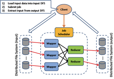
Apache Hadoop is an open source framework written in JAVA to perform distributed storage and computing of very large dataset [3]. Traditional approaches used powerful computer to process these huge data but those were not scalable, so at some point of time they were not able to cope with continuous growth of data. Hadoop solved this problem with the help of distributed computing as it is scalable. Hadoop breaks down the big data into smaller parts hence able to achieve distributed storage. It also breaks down the processing into chunks and every node performs its subtask, ultimately result of all the nodes are combined to give the final result which is returned to the application, in this way parallel and distributed processing is achieved. Figure 1 shows the general architecture of Hadoop Ecosystem.
Hadoop has its own storage area, processing area known as Map Reduce and Hadoop Distributed File System (HDFS) [3]. Map Reduce divides the large dataset into independent small data which will be processed in parallel where as HDFS spreads multiple copy of data into multiple machine which gives us reliability which has been shown in Figure 2. This task is done automatically by Hadoop Ecosystem hence programmer need not worry about it, which means we can write scale free programmes.
We initially had Hadoop-GIS for this which was built on Hive, but this thing became too difficult as we were unable to do traditional map reduce job. Whereas SpatialHadoop is directly integrated into in the Hadoop making it more efficient than Hadoop-GIS [16]. SpatialHadoop provided tools for the developers and researchers to implement new spatial operations in the system efficiently. We need to use hadoop but unfortunately hadoop is not able to process spatial data efficiently. For example: Range query is better performed by SpatialHadoop compared to range query perform by hadoop as it takes less time on SpatialHadoop. But this type of facilities was not present in Hadoop-GIS and their counter parts hence they were very limited to the functionalities they came with. For the visualization purpose of geospatial big data, we have a mapreduce based framework that is built on top of Hadoop and is known as Hadoopviz.
Hadoopviz is one of the open source tool and can produce giga-pixel images for spatial big data. It is an important tool to learn about geospatial data visualization which helps in detecting interesting patterns and relationships in the given data easily and quickly. Hadoopviz is extensible and this makes it more industry-friendly. It provides a large variety of data visualizations and it uses a 3-phase technique called partition-plot-merge. Hadoopviz can visualize in two forms, they are single level visualization and multilevel visualization. In single level visualization, it produces an image that shows all information in single level whereas in multilevel visualization the information is shown through multiple levels and produces multilevel gigapixel images [17].
4 GEOSPARK
Spark is the hottest tool to analyse and work on Big Data. Now-a-days most of the companies are using Apache Spark as it provides batch processing as well as real time processing and it is 100 times faster than Hadoop. Spark is written in Scala and performs in-memory computation. Some high level tools supported by Apache Spark are Spark SQL, Spark MLlib, GraphX, Hive and Spark streaming [3]. When it combines with Hive it is known as SHARK, and SHARK is 100 times faster than Hive. Machine learning algorithms are best suited in this framework and it is an interesting feature of Spark. It not only does faster batch processing but also does Realtime processing, interactive data analysis which in turn makes faster decision making. It also supports iterative algorithm; this is not easily done in Hadoop. Apache Storm is also a good contender for the real time processing but we use Spark over it because of the following reasons:
-
•
It does not support integration with Hadoop
-
•
It only supports real time processing
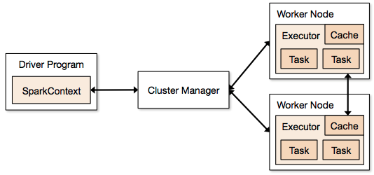
Apache Spark provides us both reliability and speed by giving all the features which Storm could not. Spark has two type of programs i.e. Driver Program which run on Master andWorker Program which runs on Slave. Spark Context is responsible for the connection to the Cluster Manager which in turn allocates the resources on the slave(worker) nodes which has been shown in Figure 3.
Spark is extremely flexible as not only it has its own cluster manager but it connects to other sources like Apache Memos and Hadoop (HDFS). It has integrated with Hadoop as they both belong to the same family so if you are running Hadoop and you want to switch over to Spark then you can run Spark on the top of the Hadoop hence saving all the data migration time from HDFS to Spark. It can also combine with Apache Cassandra, OpenStack Swift, Amazon S3.
As we are witnessing that Geospatial data is becoming a Big Data problem and people were using Hadoop to tackle geospatial problem. Since Spark is so much faster than Hadoop people tried to use Spark instead of Hadoop to solve various type of analysis of geospatial data, but unfortunately Spark had no support for Spatial data and operation. GeoSpark tries to solve this problem by extending the core of Apache Spark and providing tools to tackle geospatial data [18].
5 OBJECTIVE OF THE PRESENT STUDY
In the preent paper, it has discussed about different frameworks like Hadoop, spark and the frameworks which are built on top these Hadoop and Spark like Hadoop-GIS, HadoopViz, SpatialHadoop and GeoSpark. All these frameworks are used for geospatial big data analytics. The objective the present study is to make everyone familiar about these tools, about their architecture and working as they are specially built for geospatial data and the people working in the field of geospatial data may need these tools. Hadoop-GIS built to handle geospatial big data but was unable to perform mapreduce job. SpatialHadoop is built on the top of hadoop and can perform different geospatial operations on the given geospatial big data. HadoopViz, this was also built on top of Hadoop and is used for visualization of geospatial big data in gigapixels. GeoSpark is built on the top of Spark and can perform geospatial operations on given geospatial data but it is faster than SpatialHadoop. This study makes it clear that which tool is required for differnt tasks related to geospatial big data.
6 ARCHITECTURE COMPARISON
Since It has been dealt with SpatialHadoop and GeoSpark for geospatial big data analytics, it is important to know the difference between their architecture and working.
6.1 Architectural view of SpatialHadoop
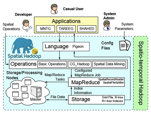
SpatialHadoop is a full fledged MapReduce framework with native support for geospatial data and it overcomes the limitation of Hadoop-GIS. The architecture of SpatialHadoop consists of the following four layers[19].
-
•
Language Layer: The language used in SpatialHadoop is pigeon which is an extension of pig. It is because of this language only that SpatialHadoop has the ability to add geospatial datatypes, functions and operations.
-
•
Operation Layer: The different type of geospatial operations can be performed by SpatialHadoop like range query, KNN, geospatial join etc. We can add more operations in this layer like KNN join, RNN etc.
-
•
MapReduce Layer: This layer of SpatialHadoop runs mapreduce program. The input files supported by SpatialHadoop are geospatially indexed. It is better that traditional Hadoop as it adds two main components as follows:
-
1.
Geospatial File Splitter: It is an extension of a file splitter that is used in Hadoop system.
-
2.
Geospatial Record Reader: It reads the slitted file originating from input files and for efficient processing it uses local index.
-
1.
-
•
Storage: In Hadoop the input files are non indexed heap files, but SpatialHadoop makes geospatial index structure within the HDFS. Due to this, it has two-level index structure of global and local indexing. Global index divides the data across all the nodes while the local indexes with the node. Architectural view of SpatialHadoop has been illustrated in Figure 5.
6.2 Architectural view of GeoSpark
To handle large volume of geospatial data , it has used GeoSpark as it is an in-memory cluster computing system. It is an extension of Apache Spark which supports geospatial datatypes, indexes and operations which has been illustrated in Figure LABEL:fig5.
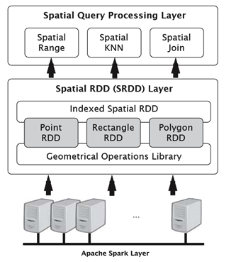
The architecture of GeoSpark consists of the following three layers:
-
•
Apache Spark Layer: It consists of all the components present in Spark. It performs loading and querying data.
-
•
Geospatial Resilient Distributed Dataset Layer: This layer extends the Spark. There are three types of RDD in this layer i.e. Point, Rectangle and Polygon RDD. It contains geometrical operations library for every RDD.
-
•
Geospatial Query Processing Layer: It is used to perform different types of geospatial queries
7 RESULT and DISCUSSION
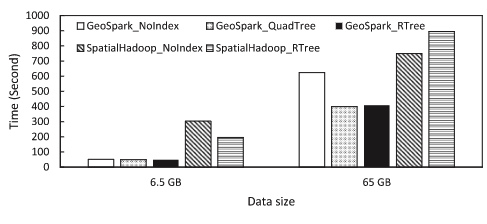
In the present research paper, it has discussed the architectural view of both the open source frameworks. Both of these tools are powerful and handy to use and can efficiently handle geospatial big data analytics. It has the capability to add more functionalities and operations in each of these tools as per the requirements. Figure 6 and Figure 7 describe the runtime analysis between SpatialHaddop and GeoSpark according to the cluster size. From the graph, it has been clearly shown that GeoSpark has the edge over the SpatialHadoop for geospatial big data analytics when the cluster size compared with time span for geospatial big data processing.

Since no tool is perfect and have merits and demerits. Table 1 represents the merits and demerits of SpatialHadoop and GeoSpark.
| Tools | Merit | Demrit |
|---|---|---|
| SpatialHadoop | 1-Uses MapReduce framework, | Extremely slow |
| 2-Basic functionalities of Hadoop like reliability, | when compared to | |
| availability, scalability etc. | GeoSpark[18] | |
| GeoSpark | 1-Uses MapReduce framework, | 1-Limited community support, |
| 2-Derived from Apache Spark, | 2-Only supports JAVA and SCALA, | |
| 3-Much faster than SpatialHadoop |
8 Conclusions
In this paper, it has discussed the two important geospatial big data analytical tools i.e. SpatialHadoop and GeoSpark for geospatial data processing. It has also described the certain architectural comparative analysis between these two open source tools which handle geospatial big data efficiently which build on the top of Hadoop and Spark. Both GeoSpark and Spatial-Hadoop are efficient in handling geospatial data but GeoSpark has edge over Spatial-Hadoop as it is much faster for realtime processing of geospatial big data. In future studies, it has been planned to implement in disaster mitigation and management as well as geospatial health information infrastructure management for better predictive analytics.
References
- [1] Raghavendra Kune, Pramod Kumar Konugurthi, Arun Agarwal, Raghavendra Rao Chillarige, and Rajkumar Buyya, “The anatomy of big data computing,” Software: Practice and Experience, vol. 46, no. 1, pp. 79–105, 2016.
- [2] Ahmed Eldawy, “Spatialhadoop: towards flexible and scalable spatial processing using mapreduce,” in Proceedings of the 2014 SIGMOD PhD symposium. ACM, 2014, pp. 46–50.
- [3] Jia Yu, Jinxuan Wu, and Mohamed Sarwat, “Geospark: A cluster computing framework for processing large-scale spatial data,” in Proceedings of the 23rd SIGSPATIAL International Conference on Advances in Geographic Information Systems. ACM, 2015, p. 70.
- [4] Ahmed Eldawy, M Mokbel, and Christopher Jonathan, “Hadoopviz: A mapreduce framework for extensible visualization of big spatial data,” in IEEE Intl. Conf. on Data Engineering (ICDE), 2016.
- [5] Ahmed Eldawy and Mohamed F Mokbel, “Spatialhadoop: A mapreduce framework for spatial data,” in 2015 IEEE 31st International Conference on Data Engineering. IEEE, 2015, pp. 1352–1363.
- [6] Dubey Harishchandra Samaddar. A. B Gupta R.D. Barik, Rabindra K. and P.K. Ray, “Foggis: Fog computing for geospatial big data analytics,” in 3rd IEEE Uttar Pradesh Section International Conference on Electrical, Computer and Electronics. IEEE, 2016.
- [7] A. Monteiro, H. Dubey, L. Mahler, Q. Yang, and K. Mankodiya, “Fit: A fog computing device for speech tele-treatments,” in 2016 IEEE International Conference on Smart Computing (SMARTCOMP), May 2016.
- [8] Admir Monteiro; Leslie Mahler; Umer Akbar; Yan Sun; Qing Yang; Kunal Mankodiya Harishchandra Dubey, “Fogcare: A fog-assisted internet of things for smart telemedicine,” Future Generation Computer Systems, 2016.
- [9] Harishchandra Dubey, Jon C. Goldberg, Mohammadreza Abtahi, Leslie Mahler, and Kunal Mankodiya, “Echowear: Smartwatch technology for voice and speech treatments of patients with parkinson’s disease,” in Proceedings of the Conference on Wireless Health, New York, NY, USA, 2015, WH ’15, pp. 15:1–15:8, ACM.
- [10] Harishchandra Dubey, Jing Yang, Nick Constant, Amir Mohammad Amiri, Qing Yang, and Kunal Makodiya, “Fog data: enhancing telehealth big data through fog computing,” in Proceedings of the ASE BigData & SocialInformatics 2015. ACM, 2015, p. 14.
- [11] Jae-Gil Lee and Minseo Kang, “Geospatial big data: challenges and opportunities,” Big Data Research, vol. 2, no. 2, pp. 74–81, 2015.
- [12] Konstantinos Evangelidis, Konstantinos Ntouros, Stathis Makridis, and Constantine Papatheodorou, “Geospatial services in the cloud,” Computers & Geosciences, vol. 63, pp. 116–122, 2014.
- [13] Arup Dasgupta, “Big data: The future is in analytics,” Geospatial World, April, 2013.
- [14] Yan Ma, Haiping Wu, Lizhe Wang, Bormin Huang, Rajiv Ranjan, Albert Zomaya, and Wei Jie, “Remote sensing big data computing: challenges and opportunities,” Future Generation Computer Systems, vol. 51, pp. 47–60, 2015.
- [15] RK Barik, AB Samaddar, and RD Gupta, “Investigations into the efficacy of open source gis software,” 2009.
- [16] Wikipedia contributors, “Geospatial analysis,” Wikipedia,TheFreeEncyclopedia,30%****␣3.SpatialHadoop.bbl␣Line␣100␣****Aug.2016.
- [17] Renato Barrera, Andrew Frank, Khaled Al-Taha, and NCGIA Maine Orono, “Temporal relations in geographic information systems: A workshop at the university of maine, orono, october 12-13, 1990 (91-4),” 1991.
- [18] Gema Bello-Orgaz, Jason J Jung, and David Camacho, “Social big data: Recent achievements and new challenges,” Information Fusion, vol. 28, pp. 45–59, 2016.
- [19] Xiaolong Jin, Benjamin W Wah, Xueqi Cheng, and Yuanzhuo Wang, “Significance and challenges of big data research,” Big Data Research, vol. 2, no. 2, pp. 59–64, 2015.