Bulgarian Academy of Sciences,
11email: nido@math.bas.bg 22institutetext: Geophysical Institute
Bulgarian Academy of Sciences
22email: gjordanov@geophys.bas.bg 33institutetext: Department of Mathematical and Statistical Sciences
University of Colorado Denver
33email: jan.mandel@ucdenver.edu
WRF-Fire Applied in Bulgaria
Abstract
WRF-Fire consists of the WRF (Weather Research and Forecasting Model) coupled with a fire spread model, based on the level-set method. We describe a preliminary application of WRF-Fire to a forest fire in Bulgaria, oportunities for research of forest fire models for Bulgaria, and plans for the development of an Environmental Decision Support Systems which includes computational modeling of fire behavior.
Keywords:
Wildland fire modeling, forest fires, coupled atmosphere-fire modeling, level-set method, Decision Support System1 Introduction
Forest fires are a problem in most south-European countries, because of the dry climate during the summer and the year-round high temperatures. Statistics have been done among the south-European EU member states, where is clear that the number of the forest fires has increased rapidly in the last 15 years along with the climate change. In addition, increased pace of development puts more people and property into harm’s way in a wildfire. Bulgaria as part of this region also has huge problems with wildland fires. Statistics have been maintained in Bulgaria for the last 30 years, and the number of forest fires increases every year [6, 10]. Even though the number of wildfires is increasing and the consequences are not only of environmental, but also of economical and social significance, a proper solution has not been found neither for Bulgaria nor for the rest of the south EU member states. At present, most of the countries suffering from wildfires are dealing with the disaster at the moment of its occurrence. After much controversy, the role of forest fires as a natural part of the ecosystem and the importance of the fuel accumulation were recognized in North America, where prescribed burns are now an integral part of forest management to reduce the fuel, and software tools can play an important role in the fire management as well in the evaluation of prescribed burns [7]. Decision support tools integrating models and observations from a variety of sources are of great interest in Bulgaria also [5].
Bulgaria has started a nice initiative by opening a center in Sofia on 7th of July 2007 to provide the disaster control units with adequate, real time information and to ensure better coordination and effectiveness in the prevention of natural hazards. It is the first initiative in the policy makers sector with such orientation. The center is named Aero-Spatial Observation Center (ASOC). It is aimed to improve and streamline the process of early warning, prediction and monitoring of natural disasters and accidents on a national scale. It allows discovering and following the dynamics of wildland and forest fires, floods, to estimate the loss of forest, control the conditions of the vegetation, soil humidity and erosion as well as air pollution. The system operates on national level and is also used by other governmental organizations e.g. Ministry of Economy and Energy, Ministry of Environment and Water Supplies, Ministry of Agriculture and Forestry, and others. The center operates 24/7. However ASOC still lacks a system for automated satellite image recognition and early detection of forest fires, floods, and other natural or human-caused disasters. That is why our team from the Bulgarian Academy of Sciences has started its own research project dedicated to the forest fires models and tools for fire simulations.
After an analysis of the literature, we have identified WRF-Fire [9] as a free Linux-based model which can simulate open area fires not only in the U.S., but also in Bulgaria, when the run process is modified to ingest data available in Europe. WRF contains the WRF Preprocessing System (WPS) [14, Chapter 3], which can input meteorological and land-use data in a number of commonly used formats. WPS has been extended to process fine-scale land data for use with the fire model, such as topography and fuel [2] [14, Appendix A]. While the format of meteorological data has largely stabilized, the ingestion of fire-modeling data was developed for U.S. sources only, and it may require further preprocessing for other countries.
2 Coupled Atmosphere-fire Modeling by WRF-Fire
This section is based on [9], where more details can be found.
Fire models range from simple spread formulas to sophisticated computational fluid dynamics and combustion simulations, see the review in [13], and also [9, p. 50]. However, a fire behaviour model in a Decision Support System should be faster than real time in order to deliver a prediction, which dictates a compromise between the spatial resolution, the processes to be modeled, and fast execution.
Weather has a major influence on wildfire behavior; in particular, the wind plays a dominant role in the fire progress and shape. Conversely, the fire influences the weather through the heat and vapor fluxes. Fire heat output can easily reach the surface intensity of , and the fast-rising hot air causes a significant air motion, which affects the atmosphere also away from the fire. It is known that a large fire “creates its own weather.” The correct wildland fire shape and progress result from the two-way interaction between the fire and the atmosphere [3, 4].
2.1 Overview of the Software
WRF-Fire [9] combines the Weather Research and Forecasting Model (WRF) [15] with a semi-empirical fire spread model. WRF-Fire got its start in [12], where a combination of the tracer-based model from [3] with WRF was proposed, a road map was formulated, and the fundamental observation was made that the innermost domain, which interacts directly with the fire model, needs to run in the Large Eddy Simulation (LES) mode. However, instead of tracers, the fire code in WRF-Fire was developed [9] based on the level-set method [11], partly because the level-set function can be manipulated more easily than tracers for the purposes of data assimilation. The code in WRF-Fire for the fire spread rate and feedback to the atmosphere was taken from [3, 4] without any significant changes, and the initial code for the WRF interface was taken from [12].
In the semi-empirical model, the fire spread rate in the normal direction to the fireline is assumed to be a function of the fuel properties, the wind speed close to the ground, and the terrain slope. The fraction of the fuel left is assumed to be an exponential function of the time from ignition. The semi-empirical formulas were derived from laboratory experiments, and the coupled model was verified on several large fires in an earlier implementation, called CAWFE [4], with the fire propagation by tracers and atmospheric modeling by the Clark-Hall weather code. WRF-Fire takes advantage of this validation and implements a subset of the physical model from [3, 4]: the physical model is the same, but the fire spread in WRF-Fire is implemented by the level-set method, and the weather model is replaced by WRF, a supported standard community weather code. WRF can be run with several nested refined meshes, called domains in meteorology, which can run different physical models. WRF-Fire takes advantage of the mature WRF infrastructure for parallel computing and for data management. An important motivation for the development of the WRF-Fire software was the ability of WRF to export and import state, thus facilitating data assimilation (input of additional data while the model is running), which is essential for fire behaviour prediction from all available data [8].
2.2 Mathematical Methods
Mathematically, the fire model is posed in the horizontal plane. The semi-empirical approach to fire propagation used here assumes that the fire spreads in the direction normal to the fireline at the speen given by the modified Rothermel’s formula
| (1) |
where is the backing rate (spread rate against the wind), is the spread rate in the absence of wind, is the wind correction, and is the terrain correction. Here, is the wind vector, is the terrain gradient vector, and is the normal vector to the fireline in the direction away from the burning area. In addition, the spread rate is limited by . Once the fuel is ignited, the amount of the fuel at location is given by
| (2) |
where is the time, is the ignition time, is the initial amount of fuel, and is the time constant of fuel (the time for the fuel to burn down to of the original quantity). The coefficients , , , , , , , and in (1) and (2) are data.
The heat fluxes from the fire are inserted into the atmospheric model as forcing terms in the differential equations of the atmospheric model into a layer above the surface, with exponential decay with altitude. The sensible heat flux is inserted as the time derivative of the temperature, while the latent heat flux as the time derivative of water vapor concentration. This scheme is required because atmospheric models with explicit timestepping, such as WRF, do not support flux boundary conditions. The heat fluxes from the fire to the atmosphere are taken proportional to the fuel burning rate, . The proportionality constants are again fuel coefficients.
For each point in the plane, the fuel coefficients are given by one of the 13 Anderson categories [1]. The categories are developed for the U.S. and different countries use different fuel schemes. WRF-Fire provides for the definition of the categories as input data, which allows the software to adapt to other countries.
The burning region at time is represented level set function by a as the set of all points where . It is known that the level set function satisfies the partial differential equation [11]
| (3) |
where is the Euclidean norm of the gradient of . Equation (3) is solved numerically by the finite difference method.
In each time step of the atmospheric model, first the winds are interpolated from the atmopheric model grid to a finer fire model grid. The numerical scheme for the level set equation (3) is then advanced to the next time step value, the time of ignition is set for any nodes that started burning during the time step, and the fuel burned during the time step is computed by quadrature from (2) in each fire model cell. The resulting heat fluxes are averaged over the fire cells that make up one atmosphere model cell, and inserted into the atmospheric model, which then completes its own time step.
3 Initialization and Computational Results
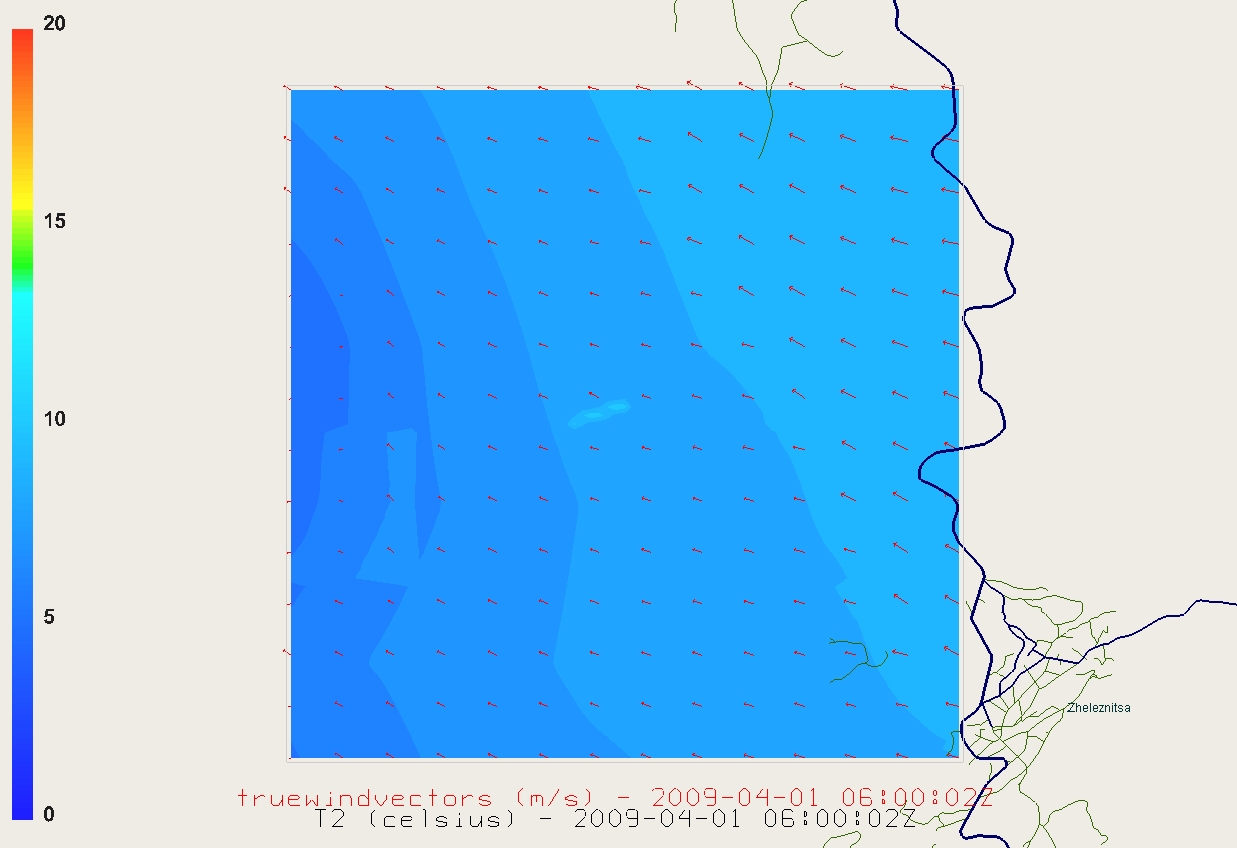
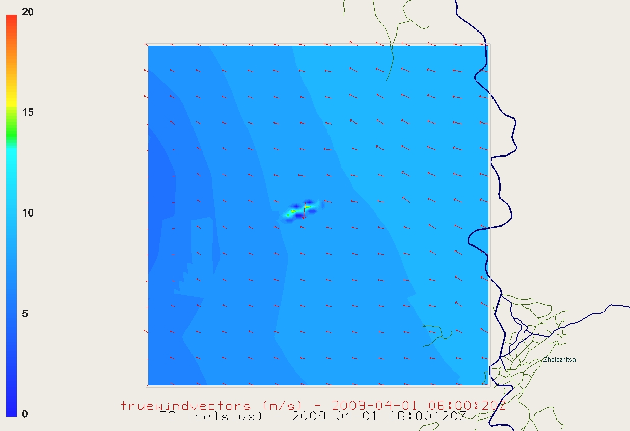
WRF-Fire v.3.2 is used for the simulation. The model consists of one domain of size 4 by 4 km, with horizontal resolution of 50 m for the atmosphere mesh, 80 by 80 grid cells, and with 41 vertical levels from ground surface to 100hPa. There is no nesting. The domain is located 4 km west from village Zheleznitsa in the south-east part of Sofia district. This domain is covering the low part of the forest on Vitosha mountain. The ignition line is located in the center of the domain, it is 345 m long and the ignition is made at 01 APR 2009, 06:00:02UTC (2 seconds after the start of the simulation). The time step used in this simulation is 0.5 s. The boundary conditions are specified and are delivered from the WRF preprocessor WPS. The WRF physics parameterizations used are [14, Chapter 5]: Microphysics - Lin et al. scheme (mp_physics = 2), Longwave radiation - RRTM scheme (ra_lw_physics = 1), Shortwave Radiation - Dudhia scheme (ra_sw_physics = 1), Surface Layer - MM5 similarity (sf_sfclay_physics = 1), Land Surface - 5-layer thermal diffusion (sf_surface_physics = 1), Planetary Boundary layer - Yonsei University scheme (bl_pbl_physics = 1). Instead of real fuel data, the fuel used in the fire simulation is based on the altitude (fire_fuel_read=1). The large-scale meteorological background data has 1 degree horizontal resolution and is obtained from NCEP Global Analysis Data. The input for land cover and land use data is from the standard data sources of WRF obtained from USGS with 1km resolution with global coverage (http://edc2.usgs.gov/glcc/glcc.php). The terrain input is also from the standard WRF data sources, USGS with 1 km resolution.
Clearly, the resolution of the land cover and the terrain data is too coarse for realistic high-resolution studies, but this is the first step of the testing the WRF-Fire capabilities to work with real data in Bulgaria. For future experiments, more detailed data will be used. We are in the process of acquiring databases of high-resolution topography and databases of fuel data, which specify the type of trees (oak, or a type of conifer). We expect to specify the custom fuel categories available in WRF-Fire to input the data for Bulgarian mountains.
In Figs. 1 – 3, we have given the temperature change in the first stage of the fire propagation, the stage of the fire when the flame is very strongly burning, and the last picture is with fire intensity slowing down. The three pictures show also the wind direction and the fire propagation line. The simulation scenario is a real representation of possible forest fire at Vitosha mountain, 10 km south from Sofia. The results from this experiment prove the capabilities of the model to work with real data for areas in Bulgaria and to give results suitable for forecasting the propagation of the fire line. The coupling of meteorological model with fire model gives us the abilities to take into account in our experiments the influence of the wind on the fire, and, conversely, the winds created by the fire itself. Obtaining as good meteorological and land data as possible is very important for getting adequate results in future real cases.

4 Conclusion and Future Plans
In this paper we have described how a wildland fire in Vitosha mountain can be simulated by adapting WRF-Fire v.3.2. Since we were limited by the real data we had and used idealizations and approximations for the fuel, the fire was not real, but it does approximate a possible real scenario. We have used raw data with approximations, because the real data is not available yet for our research.
Our future goal is to incorporate successfuly real data from the wildland fire, which occured near by the village Leshnikovo in the region of Haskovo, municipality of Harmanli in August 2009. For the new data, we plan to use 100 meters resolution land-use and land-cover data instead of the 1 km now, and high-resolution topography along with real fuel data. WRF-Fire is still an experimental tool for wildland modelling. Our team is aware that most of its applications are adapted for the U.S. territory and running it with Bulgarian data has added new features to the model specifics. We intend to make all results and succesful runs available online for other WRF-Fire users.
Acknowledgements
This work was supported by the European Social Fund and Bulgarian Ministry of Education, Youth and Science under Operative Program “Human Resources Development,” Grant BG051PO001-3.3.04/40, the project DMU 02-14 “Collecting and Processing of Data Concerning Wild land Fires, Occurred on the Bulgarian Territory in the Recent Years by Using Weather Research and Forecasting Model-Fire (WRF-Fire)”, and by the U.S. National Science Foundation under grants AGS-0835579 and CNS-0719641.
References
- [1] Anderson, H.E.: Aids to determining fuel models for estimating fire behavior. USDA Forest Service, Intermountain Forest and Range Experiment Station, Research Report INT-122 (1982), http://www.fs.fed.us/rm/pubs_int/int_gtr122.html
- [2] Beezley, J.D.: How to run WRF-Fire with real data. http://www.openwfm.org/wiki/How_to_run_WRF-Fire_with_real_data (visited July 2010)
- [3] Clark, T.L., Coen, J., Latham, D.: Description of a coupled atmosphere-fire model. International Journal of Wildland Fire 13, 49–64 (2004)
- [4] Coen, J.L.: Simulation of the Big Elk Fire using coupled atmosphere-fire modeling. International Journal of Wildland Fire 14, 49–59 (2005)
- [5] Dobrinkova, N., Nedelchev, L.: PERUN – a system for early warning and simulation of forest fires and other natural or human-caused disasters. In: Adakin, E.E., Zakonnova, L.I., Vertchagina, I.Y., Dolganov, D.N. (eds.) Education and science. Kemerovskii State University (2008), VII International Scientific Conference “Nauka i obrazovanie”, Belovo, Russia, March 14–15, 2008
- [6] Editorial: Forest fires reach catastrophic scales (in Bulgarian). Ecopolis 48 (2001), http://www.bluelink.net/bg/bulletins/ecopolis12/1_os_1.htm
- [7] Finney, M.A., McHugh, C.W., Grenfell, I.C.: Stand- and landscape-level effects of prescribed burning on two Arizona wildfires. Canadian Journal of Forest Research – Revue Canadienne de Recherche Forestiere 35, 1714–1722 (July 2005)
- [8] Mandel, J., Chen, M., Franca, L.P., Johns, C., Puhalskii, A., Coen, J.L., Douglas, C.C., Kremens, R., Vodacek, A., Zhao, W.: A note on dynamic data driven wildfire modeling. In: Bubak, M., van Albada, G.D., Sloot, P.M.A., Dongarra, J.J. (eds.) Computational Science - ICCS 2004, Lecture Notes in Computer Science, vol. 3038, pp. 725–731. Springer (2004)
- [9] Mandel, J., Beezley, J.D., Coen, J.L., Kim, M.: Data assimilation for wildland fires: Ensemble Kalman filters in coupled atmosphere-surface models. IEEE Control Systems Magazine 29, 47–65 (June 2009)
- [10] National Fire Safety and Civil Protection Service of Bulgaria: Statistics – Forest fires (in Bulgarian). http://www.nspbzn.mvr.bg/Sprav_informacia/Statistika/gorski.htm (visited July 2010)
- [11] Osher, S., Fedkiw, R.: Level set methods and dynamic implicit surfaces. Springer-Verlag, New York (2003)
- [12] Patton, E.G., Coen, J.L.: WRF-Fire: A coupled atmosphere-fire module for WRF. In: Preprints of Joint MM5/Weather Research and Forecasting Model Users’ Workshop, Boulder, CO, June 22–25, pp. 221–223. NCAR (2004), http://www.mmm.ucar.edu/mm5/workshop/ws04/Session9/Patton_Edward.pdf
- [13] Sullivan, A.L.: A review of wildland fire spread modelling, 1990-present. International Journal of WildLand Fire 18, 347–403 (2009)
- [14] Wang, W., Bruyère, C., Duda, M., Dudhia, J., Gill, D., Lin, H.C., Michalakes, J., Rizvi, S., Zhang, X., Beezley, J.D., Coen, J.L., Mandel, J.: ARW version 3 modeling system user’s guide. Mesoscale & Miscroscale Meteorology Division, National Center for Atmospheric Research (July 2010), http://www.mmm.ucar.edu/wrf/users/docs/user_guide_V3/ARWUsersGuideV3.pd%f
- [15] WRF Working Group: Weather Research Forecasting (WRF) Model (visited July 2010), http://wrf-model.org