On the Efficiency of Underground Systems in Large Cities
Abstract
We report an analysis of the accessibility between different locations in big cities, which is illustrated with respect to London and Paris. The effects of the respective underground systems in facilitating more uniform access to diverse places are also quantified and investigated. It is shown that London and Paris have markedly different patterns of accessibility, as a consequence of the number of bridges and large parks of London, and that in both cases the respective underground systems imply in general increase of accessibility.
pacs:
89.75.Fb, 02.10.Ox, 89.65.LmUnderground systems have a critical rule in metropolitan areas, affecting urban economic development, people transportation systems, car dependence with related pollution problems, as well as the urban form. Therefore, in the global debate about urban sustainability, underground and other transportation systems were and still are big and controversial issues, to the extent that the quantification of their impact represents a challenge for city planners and local administrations Newman1999 ; Marshall2001 ; Banister2007 . In this letter, we report an analysis of the accessibilities and the effects of the underground systems in the central area of London and Paris street network (area of 13 km2). In order to do so, we first transform the streets of these cities into complex networks Barabasi2002Survey ; Barabasi2007 ; Costa2007Survey so that every confluence of three or more streets becomes a node, while the streets themselves correspond to the links, and then calculate the diversity entropy of each node. The latter measurement is particularly useful to quantify the potential of each node in accessing in a balanced and homogeneous manner other nodes at specific scales. The mathematical definition of the diversity entropy of the node is given as Travencolo2008 ; Travencolo2008-2 ; Travencolo2009 :
| (1) |
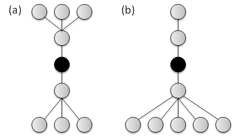
for , where corresponds to the probability that an agent performing a self-avoiding random walk reaches the node after steps departing from . The higher the diversity entropy for a given , the more balanced will be the access from node to the other nodes at that distance. Figure 1 illustrates the concept of diversity entropy for two simple graphs with different interconnecting patterns.
The data of the central areas of Paris and London were extracted from the OpenStreetMap website (http://openstreetmap.org) using the software Merkaartor markurl , which supplies information about both the positions of streets and underground routes. The street networks were coupled to their respective underground networks by linking every underground station to the closest node (considering Euclidean distance) of the street network. The final networks of Paris and London resulted with 11699 (669 from underground) nodes and 6885 (346 from underground) nodes, respectively. The average degrees of these networks are 3.02 for Paris and 2.73 for London.
The displacements of people through the cities were modeled in terms of self-avoiding random walks, so as to avoid going back along the routes. Two different types of walks were considered: respectively to the network with and without the underground system. For the latter, self-avoiding random walks were used. For the former case, i.e. including the underground system, several diffusive process starting from each station node were used so that the sum of every diffusion was considered as the weight of the nodes. The agents move over the streets network following the gradient of the nodes weights. In this approach the station nodes can be considered as local attractors of agents and these agents are naturally guided to the closest underground station. When an agent reaches a station it enters in the metro and navigates through the underground by traditional random walk. When it leaves the metro, the weights of the nodes are inverted, so that the station works as a repeller and the agent continues his self-avoid random walk in the nodes of the streets.
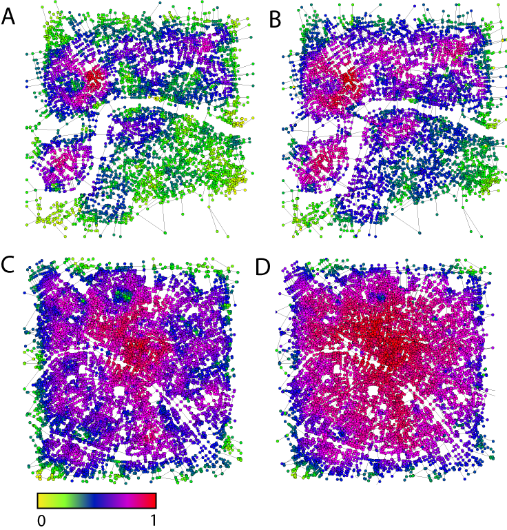
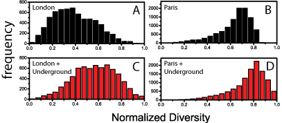
The diversity entropy was estimated for both cities with and without the underground network and a total of 10,000 walks were performed for each node, for every city. Each walk had length equal to the average shortest path length of the respective network (i.e. 41 steps for London and 37 for Paris steps). The obtained results are depicted in Figure 2, where the diversity entropy values are coded by colors. The values of diversity obtained for the two cities are organized as histograms in Figure 3. Several interesting insights can be inferred from this figure. Describing the morphological structure of both cities, we have that Paris has more uniform distribution of diversity entropy than London, meaning more homogeneous access between generic locations, probably as a consequence of its boulevards pattern. Second, as it can be clearly appreciated from Figures 2, the incorporation of the respective underground systems clearly enhanced the diversity entropy values and homogeneity in both cases. It is possible to note that the efficiency of London street network is more dependent on the underground system than in Paris, reflecting particularly well their respective different mutual dependence on urban evolution. It is also interesting to note that the fact that the river Thames is much wider than the Seine implied in the southern part of London being less integrated into the remainder network than the counterpart situation in Paris (the Seine has almost 2.5 times more bridges along central Paris than the Thames within central London). Even when restricted to the northern regions, London still has less uniform accessibility, which is possibly a consequence of the large parks found in the central region of that city (Regent’s and Hyde Parks).
The obtained results reinforces that the diversity entropy is a particularly sensitive method for revealing relationships between urban form and their underground systems. Hence there are many applications of the reported methodology, especially in assisting transportation, city planning, and urban form research.
Acknowledgments
Luciano da F. Costa thanks FAPESP (05/00587-5) and CNPq (301303/06-1) for sponsorship. B. A. N. Travençolo is grateful to FAPESP (07/02938-5) for financial support. Matheus P. Viana thanks FAPESP (07/50882-9) for financial support.
References
- (1) P. Newman and J. Kenworthy, Sustainability and Cities, Overcoming Automobile Dependence (Island press, 1999).
- (2) S. Marshall, “Planning for a sustainable future,” (Spon, 2001) Chap. The Challenge of sustainable transport, pp. 131–147.
- (3) David Banister, “Cities, mobility, and climate change,” Journal of Industrial Ecology 11, 7–10 (2007).
- (4) R. Albert and A.-L. Barabási, “Statistical mechanics of complex networks,” Rev. Mod. Phys. 74, 47 (2002).
- (5) A.-L. Barabási, “The architecture of complexity,” IEEE Control Systems 27, 33–42 (2007).
- (6) L. da F. Costa, F. A. Rodrigues, G. Travieso, and P. R. Villas Boas, “Characterization of complex networks: A survey of measurements,” Advances In Physics 56, 167 (2007).
- (7) B. A. N. Travençolo and L. da F. Costa, “Accessibility in complex networks,” Physics Letters A 373, 89 – 95 (2008), ISSN 0375-9601.
- (8) B. A. N. Travençolo and L. da F. Costa, “Hierarchical spatial organization of geographical networks,” Journal of Physics A: Mathematical and Theoretical 41, 224004 (9pp) (2008).
- (9) B. A. N. Travençolo, M. P. Viana, and L. da F. Costa, “Border detection in complex networks,” New Journal of Physics 11, 063019 (17pp) (2009).
- (10) http://merkaartor.org.