Aligned Virtual Coordinates for Greedy Routing in WSNs
Abstract
Geographic routing provides relatively good performance at a much lower overhead than conventional routing protocols such as AODV. However, the performance of these protocols is impacted by physical voids, and localization errors. Accordingly, virtual coordinate systems (VCS) were proposed as an alternative approach that is resilient to localization errors and that naturally routes around physical voids. However, we show that VCS is vulnerable to different forms of the void problem and the performance of greedy routing on VCS is worse than that of geographic forwarding. We show that these anomalies are due to the integral nature of VCS, which causes quantization noise in the estimate of connectivity and node location. We propose an aligned virtual coordinate system (AVCS) on which the greedy routing success can be significantly improved. With our approach, and for the first time, we show that greedy routing on VCS out-performs that on physical coordinate systems even in the absence of localization errors. We compare AVCS against some of the most popular geographical routing protocols both on physical coordinate system and the virtual coordinate systems and show that AVCS significantly improves performance over the best known solutions.
I Introduction
In contrast to traditional ad hocrouting protocols such as AODV [1], Geographical routing [2, 3, 5, 6], provides attractive properties for WSNs. It operates via local interactions among neighboring nodes and requires little state information that does not grow with the number of communicating nodes. In these algorithms, nodes exchange location information with their neighbors. Packets addressed to a destination must provide its location. At every intermediate hop, the subset of the neighbors that are closer to the destination is called the forwarding set (FS). Routing simply forwards a packet a node in FS. This process is repeated greedily until the packet reaches the destination. Thus, interactions are localized to location exchange with direct neighbors and there is no need for global identifiers.
Geographical routing protocols suffer from significant problems under realistic operation. First, voids –intermediate nodes whose FS relative to a destination is empty– can cause the greedy algorithm to fail [2, 3, 4, 5]. Voids require a somewhat complex and inefficient complementary routing algorithm (e.g., perimeter routing) that is invoked when they are encountered, which requires more information in addition to the location of neighbors [6]. Moreover, geographic routing has been shown to be sensitive to localization errors [7], especially in the perimeter routing phase [6, 8]; such errors can cause routing anomalies ranging from suboptimal paths to loops and failure to deliver packets. Making geographical routing protocols practical is extremely difficult [6].
Routing based on Virtual Coordinate Systems (VCS) has been recently proposed [12, 13, 14, 15, 16] to address some of the shortcomings of geographic routing. A VCS overlays virtual coordinates on the nodes in the network based on their distance (typically in terms of number of hops) from fixed reference points; the coordinates are computed via an initialization phase. VCS coordinates serve in place of the geographic location for purposes of geographic forwarding; that is, in these algorithms the FS is the set of nodes that are closer to the destination than the current node, based on a function that computes distance between points in coordinate space (e.g., Cartesian distance, or Manhattan distance). Because it does not require precise location information, VCS is not sensitive to localization errors. Further, it is argued that VCS is not susceptible to conventional voids because the coordinates are based on connectivity and not physical distance [13]. On the negative side, VCS may be sensitive to collisions and or signal fading effects in the initialization phase. Furthermore, the initialization phase requires a flood from each reference point. Finally, the coordinates should be refreshed periodically if the network is dynamic. These issues are not present in geographical routing. We call both geographic and virtual coordinate routing geometric routing.
Most existing research work in geometric routing protocols concentrates on optimizing the complementary routing algorithm such as perimeter routing[3, 2, 6], or backtracking in VCS [12, 14, 13, 16, 23]. The dominant part of the geographical routing, greedy forwarding, is largely ignored. However, since performance during greedy forwarding phase is much better than during the complementary phase, it stands to reason that increasing the percentage of paths that can be routed in the greedy mode improve overall performance. This is the primary advantage of our approach. To provide the necessary context to describe our contribution, Section II reviews related work.
The first contribution of the paper is to identify, for the first time, the VCS forwarding void that arises due to the virtual coordinate quantization noise. More specifically, since virtual coordinates are based on integer number of hops to the reference nodes, they represent a coarse approximation of node location; several nodes which are not close to each other may share the same coordinates, or have the same distance to a destination. This leads to a special type of forwarding voids which cause greedy forwarding to fail even without the presence of physical voids. We explain how this problem arises and analyze the frequency of occurrence. Other routing anomalies that arise in VCS systems [23], are also contributed to by the quantization noise. These problems are discussed in Section III.
The second contribution of this paper is an aligned virtual coordinate system (aligned VCS, or AVCS) on which the greedy forwarding phase becomes more immune to quantization noise. Specifically, nodes align themselves to a non-integral coordinate point that is a function of not only their own coordinates, but also of those of their neighbors. This alignment process significantly reduces the quantization noise, and alleviates many of the VCS forwarding voids, especially under uniform node density. AVCS is presented in Section IV.
We use simulation to compare the performance of greedy routing protocols on different coordinate systems, such as geographic coordinate system (GeoCS), VCS and the aligned VCS in Section V. The aligned VCS is able to deliver packets in the greedy forwarding mode at a much higher rate than the other coordinate systems we analyze, while achieving a good path quality that approaches that of stateful Shortest Path (SP) routing such as AODV. Using VCS, the percentage of time that the expensive complimentary void traversal algorithm is invoked is significantly reduced. Please note that aligned VCS optimizes the greedy phase, and can inter-operate with any complimentary algorithm for packets that reach voids. The path stretch of greedy forwarding is shown to be as good as SP experimentally. We present some concluding remarks and future work in Section VI.
II Background and Related Work
Stateful hop-count based routing protocols such as AODV [1], are commonly-used in Ad hoc networks. A variant, called Shortest Path (SP), can be used in sensor networks: in SP, data sinks send periodic network-wide beacons (typically using flooding). As nodes receive the beacon, they set their next hop to be the node from which they received the beacon with the shortest number of hops to the sink. Thus, with a single network wide broadcast, all nodes can construct routes to the originating node. This functionality is convenient for data gathering applications where there is a single data destination. SP can provide the optimal path in terms of path length. However, it is a stateful and reactive protocol: for each data sink, the forwarding path is needed before data transmission can begin. The storage it requires increases with the number of sinks in the network. Furthermore, it is vulnerable to mobility or other changes in the topology.
To counter these disadvantages, stateless geometric routing protocols were proposed. GFG [2], and the very similar GPSR [3], are the earliest and most widely used of this class of protocols. They consist of a Greedy Forwarding (GF) phase where each node forwards packets to the neighbor that will bring the packet closest to the destination. Each node tracks only the location information of its neighbors. Based on this information, for a packet with a given destination, a node can determine the set of neighbors closer to the destination than itself; this set is called the forwarding set for this destination. GF proceeds by picking a node from this set, typically the closest to the destination.
It is possible that GF fails, if the forwarding set is empty: a void is encountered. A complementary phase of the algorithm is then invoked to traverse the void. Typically, face routing or perimeter routing; this is an approach based planar graph theory. The general idea is to attempt to route around the void using a right hand rule that selects nodes around the perimeter of the void (details may be found in the original paper [3]). This approach is continued until a node closer to the destination than the void origin is encountered; at this stage, operation switches back to greedy forwarding. However, a problem arises if the perimeter routing intersects itself – there is a danger that the packet gets stuck in a loop. Thus, a technique for planarizing the graph to avoid the use of intersecting edges is needed: Relative Neighborhood Graph (RNG) and Gabriel Graph (GG) are 2 kinds of such planarization techniques.
GPSR and other geographic routing protocols are vulnerable to localization errors. The localization process has built in tolerances and, in general, location information is not precise. The degree of error in the location estimate depends on the localization mechanism (an error up to 40% of the radio range is considered a common case). Since GPS devices are costly, they may not be feasible for sensor networks; often, localization algorithms are employed that significantly increase the uncertainty in the location estimate (e.g., [19, 20, 22]). Both the greedy forwarding and face routing phases are susceptible to localization errors [7, 8]. While some approaches to tolerate location errors have been suggested, in general, this remains a weakness of this class of protocols. Further, the paths constructed by face routing are typically not the best path available to cross the void; they can be extremely inefficient, especially if the network is dense. Thus, additional routing protocols have attempted to optimize the face routing phase of operation [5, 4, 17]. However, most of these works optimize face routing in term of path quality, but tend to increase the overhead and the complexity. They do not address the effect of location errors on the improved schemes.
Routing based on a coordinate system, rather than location, was first proposed by Rao et al [9]. However, this approach requires a large number of nodes to serve as virtual coordinate anchor nodes (sufficient to form a bounding polygon around the remaining sensors). The drawback of having many reference points is that forming coordinates requires a long time to converge and a very high network density; the same is true for the overhead to refresh coordinates. Instead of using the virtual coordinates directly for routing, they use them to estimate location for use in geographic routing. Reachability is expected to be an issue in this protocol as geographic location is approximate; recall that it has been shown that both the greedy forwarding and the face routing phases of geographic routing are susceptible to localization errors. Similar approaches that use VCS to aid localization have been also used by other works [18, 19]. Note that these works collapse the original VCS coordinates back into 2 geographic coordinates for the purpose of routing.
GEM [10] proposed the routing based on a virtual coordinate system. A virtual polar coordinate space (VPCS) is used for localizing each node in network. A tree-style overlay is then used for routing. Thus, GEM is not stateless. Further, using the tree overlay results in poor path quality. Since it uses the VPCS to localize the network first, it tolerates only up to localization error [10].
Caruso et al recently proposed the Virtual Coordinate assignment protocol (VCap) [15]. Several similar protocols are also proposed[12, 14, 13, 16, 23]. In this approach, coordinates are constructed in an initialization phase relative to a number of reference points. Following this initialization phase, packets can be routed using the Greedy Forwarding principles, replacing node location with its coordinates: the forwarding set consists of neighbors whose coordinates are closer (different distance functions have been proposed) to the destination than the current node. The paper advocates the use of 3 reference points to assign the virtual coordinates, constructing a 3-dimensional VCS. We showed that this 3D VCS may not sufficient to map the network effectively[23]. VCap, even with 4 coordinates, is worse than GPSR both in delivery ratio (node pair reach-ability) and path quality. We also demonstrate and experimentally show that Greedy Forwarding on 3D VCap is significantly worse than normal geographically based Greedy Forwarding.
Qing et al proposed a similar protocol, called Logical Coordinate Routing (LCR), to VCap with 4 reference nodes (4D) each located at a corner for a rectangular area [13]. The choice of the number of reference nodes was not explicitly explained; however, we note that 4 corner nodes are sufficient to form a bounding polygon of a rectangular area. The authors suggested a backtracking approach to deliver packet when facing any routing anomalies. This approach requires that each hop in the forwarding path of each packet to be recorded. LCR and other VCS algorithms can benefit from the proposed Aligned VCS idea to improve the performance of the greedy phase.
The use of a Manhattan-style distance was proposed by Rodrigo et al in BVR[16]. On a VCS with much more reference nodes (typically 10 to 80), BVR suggested a different backtracking approach to forward packets back to the reference node closest to the destination when greedy forwarding fails. As we show in this paper, neither Manhattan distance nor the one proposed in BVR[16] (which we call semi-Manhattan distance) are necessarily better measures of than Euclidean distance. The use of a high number of reference nodes requires proportionately higher overhead in terms of communication and state, both during set up and refresh of the coordinates.
Papadimitriou and Ratajczak [11] conjecture that every planar 3-connected graph can be embedded on the plane so that greedy routing works. If this conjecture holds, a coordinate system where a guaranteed greedy routing may exist for any connected network. Our work may be considered a step towards this goal.
III Greedy Forwarding in VCS
The Virtual Coordinate System (VCS) for wireless routing was introduced by VCap [15]. It is attractive for use in environments where the advantages of geographic routing are desired, but are not possible due to localization errors. The virtual coordinates of each node in the network are set up by tracking the number of hops from several virtual coordinate anchors. A network using SP with sinks can be considered an -dimensional VCS as the distance to each of the sinks is tracked. The authors [15] argue that for a 2 dimensional geographical coordinate system (GeoCS), a 3-dimensional VCS is sufficient to accomplish effective Greedy Forwarding (GF). In [23] we showed that in practice this is not possible, and low delivery ratio is achieved, unless at least 4 dimensional VCS is used.
Although VCS appears to overcome voids because it is based on connectivity rather than geographical location; it does not achieve perfect greedy routing. Far from it, its greedy routing phase fails more often than geographical routing in most situations. Several routing problems that arise with VCS that result from voids perturbing the coordinate space[23]. In this paper, we show another problem in greedy forwarding in VCS that arises even when there are no physical voids. In all these problems, the result is that a packet reaches a node with no neighbors closer to the destination than itself; a local minimum is reached and greedy forwarding fails.
Consider a 4D VCS, set up according to the VCAP scheme [15, 13, 23]. Further, consider a set of nodes A, B and C with virtual coordinates as V(A), V(B) and V(C), where A and B are neighbors, and B and C are also neighbors. According to the design of VCS, we have
If we also have
where can be measured in different ways such as Euclidean distance [15, 13] and Manhattan-style distance [16], then a packet from node C may not be delivered to node A even if there is a path through node B. In simulations, we observed such conditions arising often, and in many scenarios are the primary cause of undeliverable packets. For example, in a simulation with 400 nodes that are uniformly deployed with an average density of 10 neighbors per node, greedy forwarding between nearly 20% of the pairs of the nodes failed, with 4D-VCS. For 3-D VCS, roughly 40% failed. For example, the virtual coordinates of A, B and C are
So the and measured in Euclidean Distance, while the , and measured in Manhattan distance. Even though the virtual coordinates of A, B and C satisfy the design of VCS and they are in the same neighboring chain, greedy forwarding fails at node C. We demonstrate this problem as a distance map in figure 1, where the X and Y denotes the physical location of each node, and Z denotes the Euclidean distance of each node of virtual coordinates to the node locates at (2, 8) (node A).
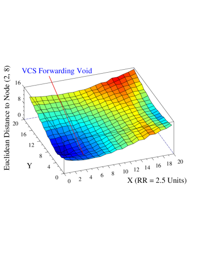
As we can see, the node located at (5, 4) (node C) has no neighbor closer to the destination (node A) per either the Euclidean or Manhattan distance of virtual coordinates. We call this problem a VCS forwarding void. A more serious forwarding void may be found in the region around location (19,6) where the virtual coordinates of all nodes around it are further away away from the destination in this figure.
The reason behind the VCS forwarding void is the virtual coordinate quantization noise. Two nodes may receive the same virtual coordinate value at a given dimension, their physical distances to the anchor node providing the dimension beacon may match
where the denotes radio range. For each hop (1 in value), the noise would be at most under unit disc assumptions. As the value of goes higher, the noise becomes bigger. Since the virtual coordinate value just reflects the distance of a node to some anchor measured in number of hops, the noise affects the greedy forwarding significantly in the networks with a large number of nodes.
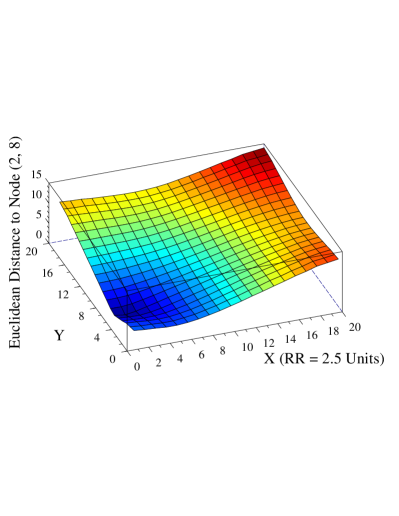
The quantization noise comes from the hop-count nature of the VCS which uses integer values to approximate continuous physical locations. A more accurate approach to mapping the network into a VCS is needed. The virtual coordinate value should reflect not only the distance to the anchor nodes, but also the connectivity of the neighborhood. We propose such an approach which we call aligned VCS (described in Section IV). The use of aligned VCS on the 20x20 grid network causes the distance map as figure 2 where the distances of all nodes to the destination node is continuously decreasing, allowing more effective greedy forwarding.
IV The Design of Aligned VCS
For geographical routing protocols, a relative high density can resolve many routing anomalies such as physical voids (ignoring the effect of localization errors). In contrast, high density may not resolve the routing anomalies in VCS [23]; it may even exacerbate them due to the quantization noise problems such as VCS forwarding void presented in section III. The complementary solutions for a void avoidance are not effective as described in section II. Consequently, the performance of geographical routing protocols on VCS is not as good as it on GeoCS with precise location information or any stateful routing protocols. A successful geographical routing protocol should be stateless, tolerate localization errors, and use greedy forwarding as much as possible in order to perform as well as on GeoCS or stateful routing protocols.
The integral-valued nature of the VCS contains quantization noise. Further, the discrete nature of the integral coordinates makes it easier to reach routing anomalies where all neighbors are of equal coordinates or equal distance to the destination. The goal of the proposed Aligned Virtual Coordinate System (AVCS) is to provide more representative and continuous coordinate and connectivity information.
IV-A Aligned VCS
The virtual coordinates of each node in the VCS is set up as the vector of the hop-counts from several anchor nodes. For any node A with a virtual coordinate vector , the virtual coordinate vector of any neighbor N of it would satisfy
The integral value of virtual coordinate at dimension cannot discriminate between two nodes with the same coordinate value. The value can only tell us what level of a routing trees rooted at the anchor nodes the two nodes belong to. However, by considering the neighbor information, which is generally different for the two nodes, a more effective and discriminating coordinate value can be achieved. More specifically, alignment refers to the process of computing the coordinates of a given node as a function of its own coordinates and the coordinates of the neighboring nodes. Thus, given the same initial coordinate value, a node A with neighbors that average a smaller virtual coordinate value than another node B, is closer to the root of the routing tree than B is. In this case, B has neighbors which average bigger virtual coordinate value is aligned further away from the root. Similarly, a node with neighbors which average roughly the same virtual coordinate value is aligned towards the middle. A possible alignment function that we consider produces an aligned virtual coordinate vector of a node as follows.
| (1) |
where the is the virtual dimension, the is the neighbor of A, and is the number of neighbors of . is the depth of aligned virtual coordinates. The aligned virtual coordinates with depth 0 stand for the original integral hop-counter virtual coordinates value. A depth of 1 indicates averaging coordinates among one-hop neighbors, and a depth of reflects taking into account neighbors that are hops away from the node. An alternative equation for aligned virtual coordinates might be
| (2) |
The estimates of the two functions are not likely to be significantly different.
IV-B Distance Measurement on Aligned VCS
In geographical routing, each data packet has to carry the coordinates value of the destination node. To make a routing decision in greedy forwarding, the distance from current node to the destination is compared to those of one-hop neighbors. The closest neighbor to the destination would be chosen as the next hop to which the packet would be forwarded. This process repeats until the packet arrives at the destination.
For a network where nodes do not move frequently, the stability of nodes keeps the aligned VCS stable. So for routing decisions, the updated aligned virtual coordinates of destination is not difficult to obtain. But if nodes with high mobility are common, the aligned virtual coordinates of nodes would turn stale quickly. For this consideration, the aligned virtual coordinates of any node as destination is not used for routing, which means that each data packet carries only the integer value virtual coordinate of the destination ( or say, ). The aligned virtual coordinates are used only for distance measurement locally. So the Euclidean distance from a given node to the destination is measured as
| (3) |
For a 4D VCS, . And the Manhattan distance can be measured by
| (4) |
Other distance functions such as the semi-Manhattan function used by BVR [16] can be measured in a similar way.
It is important to note that AVCS is quite different from works that use virtual coordinates to localize for use in geographic routing. Those works attempt to measure physical distance and not align based on connectivity. Furthermore, they compress the VCS dimensions, no matter how many, back into two geographic dimensions X and Y, losing a significant amount of information.
V Experiment
In this section, we present an experimental evaluation that illustrates the existing geographical routing protocols on physical coordinates (GeoCS), virtual coordinates (VCS) and aligned virtual coordinates (AVCS) systems. The evaluation tracks metrics such the greedy ratio (portion of paths that can be routed using greedy forwarding only) and average path length (path stretch relative to SP). The reason to choose the greedy ratio as an evaluation metric is that it reflects both the overhead and the performance of a stateless routing protocol such as GPSR; the lower the greedy ratio, the more frequently we need to use the more expensive and less efficient complimentary perimeter routing.
V-A Experimental Setup and Preliminaries
To enable scalability, we use a custom simulator written for this study; the simulator abstracts away the details of the channel and the networking protocols. Since our work targets functionality in the control plane (not the data plane), we believe that hiding the modeling details of that level should be better. The results of the simulator validate well with the NS-2 simulator [24]. However, NS-2 does not allow scaling the simulation size to the network sizes we want to study.
We study the impact of physical voids on geographical routing with different coordinate systems through a number of scenarios. For every scenario, the greedy ratio and path stretch are determined as the average of these values for every pairwise permutation of the nodes in the network; that is, one test is done for sending a packet from every node to every other node. If the packet is delivered through greedy forwarding, it counted towards the greedy ratio. We use SP, which finds the optimal routing in terms of number of hops, as the baseline for measuring path stretch. Note that SP is stateful and expensive especially if the network is dynamic or the number of destinations large.
We implemented GPSR (with both GG and RNG planarization) [3, 6], Shortest Path (SP), Greedy Forwarding on VCS [15], LCR [13] and BVR [16] on 4D VCS, to study their performance against Aligned VCS (AVCS). In fairness to BVR, the original specification suggests 10 to 80 reference points; however, we are interested in evaluating it against the other schemes with similar assumptions on the number of beacons. In addition, we believe that such a large number of reference points is impractical in many settings. The aligned VCS uses Equation (2). The simulation results show the 2 equations (1, 2) perform almost identically (less than 0.5% difference). The distance between any 2 nodes is measured through a Euclidean manner as equation (3) except BVR.
V-B Greedy Forwarding vs Shortest Path
The first study shows the performance of geographical Greedy Forwarding (GF) and Shortest Path (SP) routing in terms of path length. These results form part of the intuition for our work. More specifically, the greedy component of geographic and VCS routing is the close to the optimal SP performance. Thus, increasing the success of the greedy phase leads to improving the effectiveness of geographic and VCS routing.
Since voids cause non-greedy routing, in this study we use a grid deployment of 2500 nodes in a 50x50 units area. Each node is placed at the center of one grid. The impact of the density is studied through varying the transmission range. The path lengths of SP GF on GeoCS (greedy phase of GPSR), 4D VCS and 4D Aligned VCS with depth 1 (AVCS d1) are shown in Table I. GF on GeoCS performs the same as SP routing which means in this grid deployment without any physical voids, the stateless routing protocols perform as well as stateful one. When the radio range becomes higher, the greedy forwarding on VCS becomes worse than GF due to the increased quantization noise and the VCS forwarding anomalies. Aligned VCS does not suffer from this problem.
| Neighbors # | SP | GeoCS | 4D VCS | 4D AVCS (d 1) |
| 3.92 | 1.0000 | 1.0000 | 1.0000 | 1.0000 |
| 7.76 | 1.0000 | 1.0000 | 1.0000 | 1.0000 |
| 11.60 | 1.0000 | 1.0000 | 1.0000 | 1.0000 |
| 19.13 | 1.0000 | 1.0000 | 1.0494 | 1.0073 |
| 26.57 | 1.0000 | 1.0000 | 1.0251 | 1.0010 |
| 33.94 | 1.0000 | 1.0000 | 1.0409 | 1.0050 |
| 44.84 | 1.0000 | 1.0000 | 1.0545 | 1.0035 |
| 62.66 | 1.0000 | 1.0000 | 1.0850 | 1.0100 |
| 73.17 | 1.0000 | 1.0000 | 1.0926 | 1.0074 |
| Neighbor # | Perimeter Routing | BVR BT | LCR BT |
|---|---|---|---|
| 3.92 | 16.9200 | 2.1903 | 1.0000 |
| 7.76 | 13.1800 | 2.0996 | 1.0000 |
| 11.60 | 18.0365 | 2.1875 | 1.0000 |
| 19.13 | 23.7324 | 2.1411 | 1.0525 |
| 26.57 | 29.7087 | 2.1459 | 1.0277 |
| 33.94 | 31.7657 | 2.1609 | 1.0480 |
| 44.84 | 37.4030 | 2.1512 | 1.0564 |
| 62.66 | 41.9031 | 2.1342 | 1.1198 |
| 73.17 | 46.2990 | 2.1311 | 1.0982 |
Usually, the complementary solution for voids such as perimeter routing and backtracking cause a significant path stretch relative to SP. The path stretch of the complimentary algorithms in the previous scenario were measured (Table II). The path stretch of perimeter routing is extremely high but it is stateless, requiring no more information than greedy forwarding. BVR is considerably better, but still quite high, without requiring more information. However, almost every time that backtracking was invoked BVR required a scoped flood from the beacon which may cover half of the network in a 4D VCS. Although the path stretch of LCR is the best and approaches SP, it requires each data packet to be recorded by each node in its forwarding path; this solution is impractical for all but very lightly loaded networks. From this study, we can conclude that if the stateless routing can keep using greedy forwarding, it can provide performance close to stateful routing protocols while maintaining their desirable properties (statelessness and low overhead).
V-C Effect of Voids
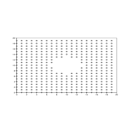
First, we study the impact of the size of a single physical void on performance. We use a uniform grid deployment of 400 nodes. The physical voids are created by taking away some nodes in the center of area. An example of such a physical void is shown in figure 3 where 29 nodes in the center are taken away. Later, we study random deployment scenarios.
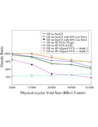
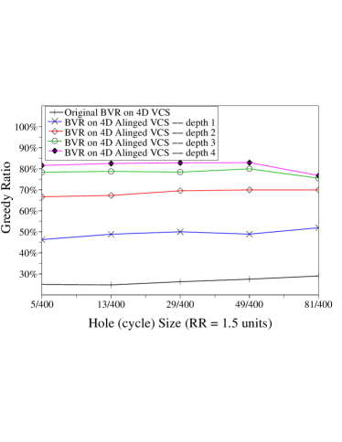
The greedy ratios of the geographical routing on different coordinate systems are shown in Figure 4. GF on 4D VCS is able to use greedy forwarding more often than GF on GeoCS. The greedy ratio on 3D VCS is stable no matter what the size of the void is. The reason may be that the anomalies of greedy forwarding on 3D VCS arise not from voids primarily. Although a localization error of around 20% of transmission range does not significantly affect the greedy ratio on GeoCS, a 40% localization error causes greedy ratio to drop considerably which leads to higher path lengths and even routing failure. Meanwhile, the geographical routing on VCS does not suffer from localization errors. The greedy ratios of BVR on 4D VCS is shown in figure 5. As we can see, since the original BVR is designed on a VCS with a relative higher dimensions (usually 10 80), its greedy ratio with only four dimensions is very low. However, increasing the number of coordinates higher, comes at a cost of increased overhead in constructing the coordinates. Even with aligned VCS depth 3, its greedy ratio remains lower than the other approaches.
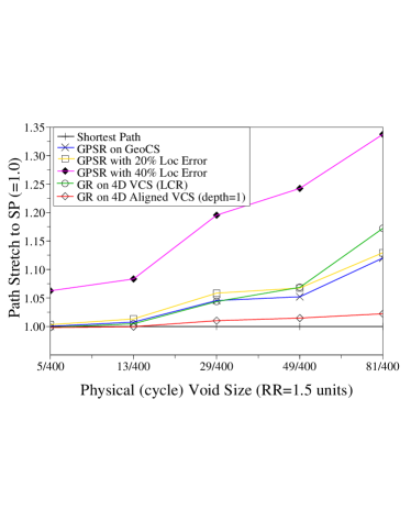
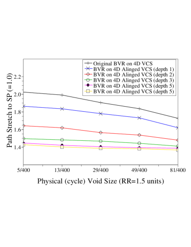
Figure 6 shows the path length of geographical routing on different coordinate systems. The primary observation from this figure is that the greedy routing on VCS is better than that on GeoCS even without any localization error, especially with a bigger physical void. It can provide path stretch close to the optimal one even with a large physical void. The path stretch of BVR is shown in figure 7. Similar to the study of greedy ratio, deeper aligned VCS is, smaller path stretch is.
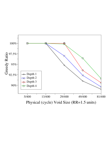
The impact of size of the void on AVCS for different alignment depths is shown in Figure 8. As expected, the deeper the alignment, the higher the greedy ratio. Although deeper than 3 aligned VCS may still help, it may not be practical if node mobility is present.
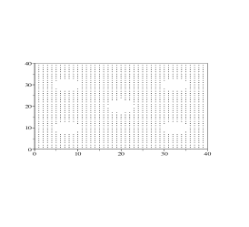
Next, we study the effect of multiple voids. In a 40x40 area with grid deployment, nodes are removed to create different number of holes. An example of 5 holes in such an area is shown in Figure 9.
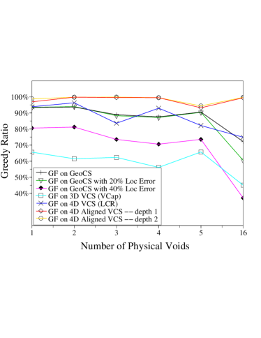
Figure 10 shows the greedy ratio of geographical routing on different coordinate systems as the number of physical voids is increased. GF on 4D VCS has a similar performance as it does on a GeoCS. The result does not support the use of VCS over GeoCS. However, the greedy ratio using aligned VCS even with only depth 1 approaches 100%, especially when the deployment of nodes is very complicated (note the one with 16 physical holes).
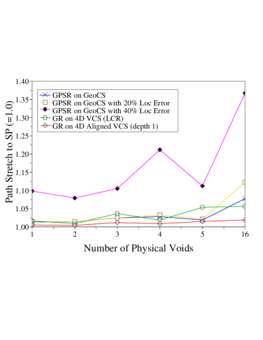
The study of path length in these scenarios is shown in Figure 11. The path stretch of greedy routing on 4D VCS (either aligned or not) is just a little smaller than it on a GeoCS for a small number of voids. As the number of voids increases, the greedy ratio of GeoCS drops, leading to a much higher path stretch. Meanwhile, the greedy ratio of VCS is still high, and it achieves good path quality as a result. With a 40% localization error, VCS significantly outperforms GeoCS.
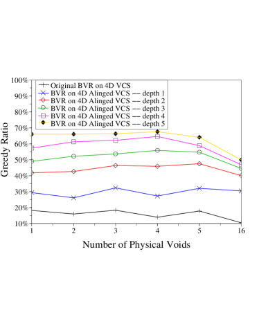
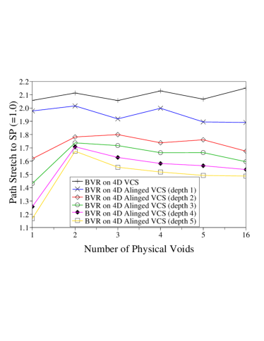
The performance of BVR in these scenarios is shown in Figure 12 and 13. Although the aligned VCS greatly helps the performance of BVR , it is still worse than other routing protocols which means its design requires a large number of dimensions (anchor nodes). Because of this, we do not include BVR in the remaining studies.
In unplanned wireless ad hoc and sensor networks deployments, the placement of nodes is more likely to be random. We study scenarios where 1600 nodes are deployed in a 30x30 area randomly. The results shown represent the mean of 20 randomly generated deployments, to tightly bind the confidence interval. We study the impact of density by increasing radio range.
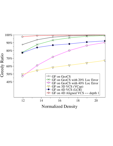
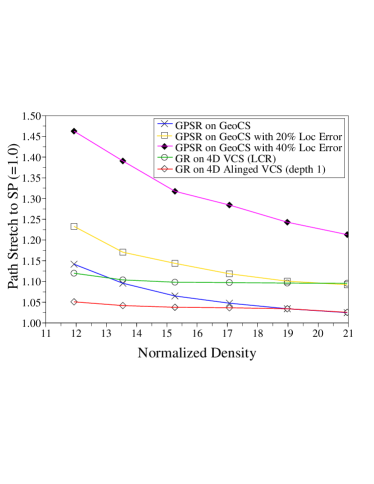
The greedy ratio in these random scenarios is shown in Figure 14. GeoCS performs very well even with 20% localization error. 4D VCS does not provide a higher greedy ratio than GeoCS which may mean that in the reality, the geographical routing on VCS may be not as good as GeoCS even with some localization errors. However, the greedy ratio with aligned VCS (even only with depth 1) is higher than any other and approaches 100% much quicker than the others. In our opinion, this result argues strongly in favor of VCS, especially when localization error is common. In a relatively sparse network, the high quality of aligned VCS makes it an attractive solution for geographical routing. Figure 15 shows the path length. Aligned VCS performs better than others except the shortest path routing.
VI Conclusion
In this paper, we first analyze the reason why the recently proposed stateless routing protocols such as GPSR can not be successful as well as traditional stateful routing protocols such as DSR and AODV since the requirement of these routing protocols: precise location may not be available mostly. We also analyze why the geographical routing on VCS may not be a replacement of it on GeoCS since the performance of it is not as well and the complementary solution for physical voids is not satisfactory. Then we argue that the way of a stateless routing protocol to be successful is to provide a performance as well as stateful ones while does not suffer from the localization errors.
The simulation shows that the greedy forwarding phase of the stateless geographical routing leads to a performance comparable with stateful routing protocols. We proposed an aligned virtual coordinate system which significantly reduces the quantization noise in traditional VCS and greatly increases the greedy ratio of these protocols. AVCS was shown to significantly outperforms GeoCS, basic VCS, and also the BVR in terms of greedy ratio and path stretch.
It is widely accepted that stateless routing protocols offer desirable properties over stateful ones. However, it is also accepted that these come at a price in terms of performance. In this paper, we show that the performance of stateless routing can approach that of stateful routing protocols, even in the presence of voids. Further, we show for the first time that VCS (with alignment) can outperform GeoCS even without localization errors.
References
- [1] C. E. Perkins and E. M. Royer, Ad hoc On-Demand Distance Vector Routing, in Proceedings of the 2nd IEEE Workshop on Mobile Computing Systems and Applications, February 1999
- [2] P. Bose, P. Morin, I. Stojmenovic and J. Urrutia, Routing with guaranteed delivery in ad hoc wireless networks, DIAL M99, Auguest 1999
- [3] B. Karp and H.T. Kung, GPSR: Greedy Perimeter Stateless Routing for Wireless Networks, MobiCom 2000
- [4] Q. Fang, J. Gao and L. Guibas, Locating and Bypassing Routing Holes in Sensor Networks, INFOCOM 2004
- [5] Sophia Fotopoulou-Prigipa and A. Bruce McDonald, GCRP: Geographic Virtual Circuit Routing Protocol for Ad Hoc Networks, MASS 2004
- [6] Young-Jin Kim, Ramesh Govindan, Brad Karp and Scott Shenker, Geographic Routing Made Practical, the Second USENIX/ACM Symposium on Networked System Design and Implementation(NSDI’05), May 2005
- [7] T. He, C. Huang, B. Blum, J. A. Stankovic and T. Abdelzaher, Range-Free Localization Schemes for Large Scale Sensor Networks, MobiCom 2003
- [8] K. Seada, A. Helmy and R. Govindan, On the Effect of Localization Errors on Geographic Face Routing in Sensor Networks, IPSN 2004
- [9] A. Rao, S. Ratnasamy, C. Papadimitriou, S. Shenker and Ion Stoica, Geo. Routing without Location Info., MobiCom 2003
- [10] J. Newsome and D. Song, GEM: Graph EMbedding for Routing and Data-Centric Storage in Sensor Networks Without Geographic Information, SenSys’03, Nov. 2003
- [11] C. H. Papadimitriou and D. Ratajczak, On a Conjecture Related to Geometric Routing, ALGOSENSORS 2004
- [12] T. Moscibroda, R. O’Dell, M. Wattenhofer, R. Wattenhofer, Virtual Coordinates for Ad hoc and Sensor Networks, ACM DIALM-POMC, October 2004
- [13] Qing Cao and Tarek F. Abdelzaher, A Scalable Logical Coordinates Framework for Routing in Wireless Sensor Networks, RTSS 2004
- [14] D. M. Nicol, M. E. Goldsby and M. M. Johnson, Simulation Analysis of Virtual Geographic Routing, in Proceedings of the 2004 Winter Simulation Conference
- [15] A. Caruso et al. GPS Free Coordinate Assignment and Routing in Wireless Sensor Networks, INFOCOM 2005
- [16] R. Fonseca, S. Ratnasamy, J. Zhao, C. T. Ee, D. Culler, S. Shenker and I. Stoica, Beacon Vector Routing: Scalable Point-to-Point Routing in Wireless Sensornets, NSDI’05, 2005
- [17] Q. Fang, J. Gao, L. J. Guibas, V. de Silva and L. Zhang, GLIDER: Gradient Landmark-Based Distributed Routing for Sensor Networks, INFOCOM 2005
- [18] R. Nagpal, H. Shrobe and J. Bachrach, Organizing a global coordinate system from local information on an ad hoc sensor networks, IPSN 2003
- [19] D. Niculescu and B. Nath, Ad Hoc Positioning System (APS), GlobalCom 2001
- [20] J. Hightower and G. Borriella, Location Systems for Ubiquitous Computing, IEEE Computer, V34, 57-66, 2001
- [21] L. Doherty, K. S. J. Pister and L. El Ghaoui, Convex position estimation in wireless sensor networks, INFOCOM 2001
- [22] A. Haeberlen, E. Flannery, A. M. Ladd, A. Rudys, D. S. Wallach and L. E. Kavraki, Practical Robust Localization over Large-Scale 802.11 Wireless Networks, MobiCom 2002
- [23] Ke Liu and Nael Abu-Ghazaleh, Virtual Coordinate Backtracking for Void Traversal in Geographic Routing, Technical report, Binghamton University, CS. Dept., Feburary, 2006.
- [24] The Network Simulator - ns-2, http://www.isi.edu/nsnam/ns/