IVS Products for Precise Global Reference Frames
Abstract
VLBI plays a unique and fundamental role in the maintenance of global reference frames which are required for precise positioning in many research areas related e.g to the understanding and monitoring of global changes, to geodesy, to space missions etc. The International VLBI Service for Geodesy and Astrometry coordinates internationally the VLBI components and resources and is tasked by IAG and IAU for the provision of products describing the Celestial Reference Frame through positions of quasars and their changes with time and also for products describing the rotation of the Earth in space. This paper summarises today’s status of the products, achieved over the last years by evolving the observing programs. It points out the activities to improve further on the product quality to meet future service requirements, which will come up with the need for highly precise global reference frames.
1 Introduction
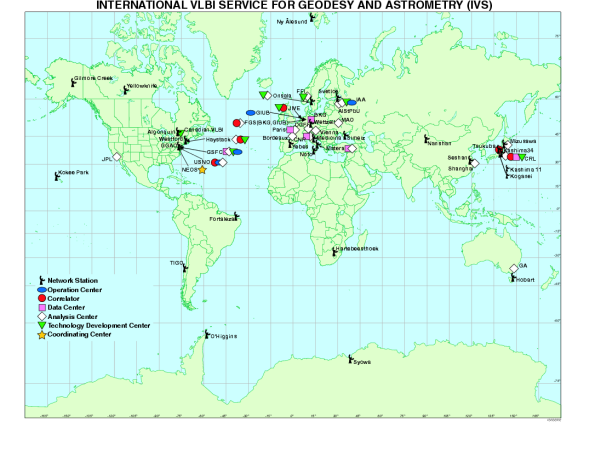
The International VLBI Service for Geodesy and Astrometry (IVS) is a service of the International Association of Geodesy (IAG), the International Astronomical Union (IAU) and the Federation of Astronomical and Geophysical Data Analysis Services (FAGS). The main task of the IVS is the coordination of VLBI components in order to guarantee the provision of the products and parameters to realize the Celestial Reference Frame (CRF), the Terrestrial Reference Frame (TRF) and the Earth Rotation with its orientation of the rotation axis in both reference frames and its angular velocity through the Earth Orientation Parameter (EOP). The EOP enables the transformation between TRF and CRF. VLBI is fundamental and unique for the realization of the CRF through a catalogue of quasar positions. The IAU tasked IVS to maintain the CRF and released a resolution in August 2001, during the General Assembly in Birmingham. VLBI contributes strongly to the TRF by the determination of station positions, in particular of baseline lengths between the stations. Due to the long intercontinental baselines VLBI is strongly supporting the scale of the TRF. Time series of station positions give information about their movements (plate motions). As VLBI provides the complete set of EOP and uniquely the UT1-UTC (DUT1) parameter and the CRF, VLBI is the key technique for the monitoring of global reference frames. The international collaboration is based on a Call for Participation in 1998 with respect to the IVS Terms of Reference (ToR). Proposals were made to operate more than 73 permanent components by 37 institutions in 17 countries. IVS has more than 250 Associate Members. Annual Reports and Meeting Proceedings are published (Vandenberg [1999], Vandenberg, Baver [2001], Vandenberg, Baver [2002] , Vandenberg, Baver [2003] , Vandenberg, Baver [2004] , Vandenberg, Baver [2000], Vandenberg, Baver [2002b] , Vandenberg, Baver [2004b]).
2 Products and improvements
When IVS started in March 1999, the demand for continuity in maintaining the reference frames forced us to employ the existing observing programs set up by the US Naval Observatory as NEOS, or by NASA as CORE. In 2001 a working group (IVS WG2) was established to review the products and the existing observing programs. The WG2 report was the basis for improving products and evolving observing programs to meet service requirements. The IVS products can be defined in terms of their accuracy, reliability, frequency of observing sessions, temporal resolution of the estimated parameters, time delay from observing to final product, and frequency of solutions. The situation before 2002 and the goals for the follow on years with IVS products are described in detailed tables in the WG2 report (Schuh et al. [2002]). The main IVS products, their current accuracies and the goals are summarized in table 1. The VLBI technique allow us to provide additional products and IVS intends to set up the extended products summarized in table 2.
As of late 2001, IVS products were generated from 3 days/week observing with 6-station networks. The time delay ranged from several days up to 4 months, with an overall average value of 60 days. Over the next years, the goals of IVS with respect to its products were the following (specific goals for each product are listed in the WG2 report tables):
-
•
improve the accuracies of all EOP and TRF products by a factor of 2 to 4 and improve the sky distribution of the CRF,
-
•
decrease the average time delay from 60 to 30 days, and designate 2 days per week as rapid turnaround sessions with a maximum delay of 3-4 days,
-
•
increase the frequency of observing sessions from 3 to 7 days per week,
-
•
deliver all products on a regular, timely schedule.
| Products | Specifications | Status | Goals (2002 – 2005) | |
| Polar Motion | accuracy |
~ , ~
|
, : | … |
| , | latency | 1 – 4 weeks …4 months | 4 – 3 days | …1 day |
| resolution | 1 day | 1 day …1 h | …10 min | |
| frequency of solution | +3 days/week | …7 days/week | ||
| UT1 - UTC | accuracy | … | … | |
| DUT1 | latency | 1 week | 4 – 3 days | … 1 day |
| resolution | 1 day | 1 day | …10 min | |
| Celestial Pole | accuracy | … | … | |
| , | latency | 1 – 4 weeks …4 months | 4 – 3 days | … 1 day |
| resolution | 1 day | 1 day | ||
| frequency of solution |
~ 3 days/week |
…7 days/week | ||
| TRF(x,y,z) | accuracy | 5 mm – 20 mm | 5mm | …2 mm |
| CRF | accurary | – | ||
| frequency of solution | 1 year | 1 year | ||
| latency | 3 – 6 months | 3 months | …1 month | |
-
1
improved distribution
| Earth Orientation Parameter additions | dUT1/dt (length of day) |
|---|---|
| ; (pole rates) | |
| Terrestrial Reference Frame (TRF) | x-, y-, z- time series |
| Episodic events | |
| Annual solutions | |
| Non linear changes | |
| Celestial Reference Frame (CRF) | Source structure |
| Flux density | |
| Geodynamical Parameter | Solid Earth tides (Love numbers h,l) |
| Ocean Loading (amplitudes and phases ) | |
| Atmospheric loading (site-dependent coefficients) | |
| Physical Parameter | Tropospheric parameters |
| Ionospheric mapping | |
| Light deflection parameter |
3 Evolving observing programs
To meet its product goals, beginning with the 2002 observing year, IVS designed an observing program coordinated with the international community. The 2002 observing program included the following sessions:
-
•
EOP: Two rapid turnaround sessions each week (IVS R1 and IVS R2), initially with 6 stations, increasing to 8. These networks were designed with the goal of having comparable and results. One-baseline 1-hr INTENSIVE sessions four times per week, with at least one parallel session.
-
•
TRF: Monthly TRF sessions with 8 stations including a core network of 4 to 5 stations and using all other stations three to four times per year.
-
•
CRF: Bi-monthly RDV sessions using the Very Long Baseline Array (VLBA) and 10 geodetic stations, plus quarterly astrometric sessions to observe mostly southern sky sources.
-
•
Monthly R&D sessions to investigate instrumental effects, research the network offset problem, and study ways for technique and product improvement.
-
•
Annual, or semi-annual if resources are available, 14-day continuous sessions to demonstrate the best results that VLBI can offer, aiming for the highest sustained accuracy.
Although certain sessions have primary goals, such as CRF, all sessions are scheduled so that they contribute to all geodetic and astrometric products. Sessions in the observing program that are recorded and correlated using S2 or K4 technology will have the same accuracy and timeliness goals as those using Mark 4/Mark 5. The new IVS observing program began in January 2002. The observing program and product delivery was accomplished by making some changes and improvements in IVS observing program resources (station days, correlator time, and magnetic media), by improving and strengthening analysis procedures, and by a vigorous technology development program.
4 Status and experiences of the new IVS Program two year after its implementation
The number of station observing days increased by about 10compared to 2001, with an additional 12campaign. Not counting CONT02, the number of observing days increased by another 12will continuously increase such that by 2005 the top dozen geodetic stations will need to be observing up to 4 days per week - an ambitious goal. Increased station reliability and unattended operations can improve temporal coverage by VLBI and also allow substantial savings in operating costs. Higher data rate sessions can yield more accurate results, and therefore nearly all geodetic stations were upgraded to Mark 5 and K5 technology. A deployment plan for the Mark 5 system was proposed. As of the end of 2003 the correlator and most of the observing stations were equipped with Mark 5 digital recording systems. All correlators were committed to handling the IVS data with priority processing for meeting timely product delivery requirements. High capacity disks were purchased and organized in a common pool to replace magnetic tapes and to obtain additional recording media capacity. The progress in communication technologies supported the breakthrough for e-VLBI. Several tests have been conducted on national, continental and global levels. Some station are already connected to fast internet links and regular applications for e-VLBI (real time or near real time) will be established. The 1-hr INTENSIVE observation sessions are routinely transferred electronically to a correlator and will soon be operational. The increased amount of VLBI data to be produced under the new observing program required Analysis Centers to handle a larger load. Partially automated analysis procedures helped to improve the timeliness of product delivery. As the official IVS product, a complete set of Earth Orientation Parameter is regularly submitted to the International Earth Rotation Service (IERS). The set is obtained as a combination of the individual solutions of the six IVS Analysis Centers (Nothnagel, Steinforth [2002]). Up to the end of the year 2001, the parameters were derived from the NEOS observations, while since January 2002 the IVS R1 and IVS R4 were used. It should be noted that up to the end of 2001 NEOS was the rapid turn around program which since January 2002 now includes the IVS R1 and R4 sessions. The objective of the rapid turn around observation sessions was to minimize the delay between the observations and the availability of the results. For the NEOS the delay was approximately 2 weeks, which has not changed by its transition to the IVS R4 as all the routine procedures were already established. For the IVS R4, as new stations were added the data shipping procedures needed to be set up to be routine. Initially this caused unexpected delays, which were overcome with time. For the IVS R1 processing, experience needed to be gained at the correlators at Bonn, Haystack and Washington during the first months. The delay between the observation to the results is approximately two weeks since April 2002. This should be regarded as significant and real progress, even though the WG2 goal of only 4 days has not been achieved. Improvements for data transmission and a higher throughput at the correlator were achieved, after the implementation of the newly developed Mark 5 digital data recording system, which has e-VLBI capabilities, allowing data transmission via high speed Internet links. The determination of DUT1 from the near-daily 1-hour observations known as ”Intensives” have been carried out since 1983 via the baseline Wettzell-Westford, since 1994 via the baseline Wettzell-Green Bank and since 2000 via the baseline Wettzell-Kokee Park. These baselines now employ Mark 5 systems . In the year 2002 a time series observed on the baseline Wettzell-Tsukba/Japan with the Japanese K4 system was set up. The regular application of fast Internet links for the INTENSIVE’s will start soon, which will allow rapid availability of DUT1. The VLBI observations from the IVS R1 and R4 allow determination of tropospheric parameters, in particular the wet zenith path delay. Since July 2003 the zenith wet path delay is an official IVS product. The University of Vienna is combining the solutions of five Analysis Centers (Schuh, Boehm [2002]).
5 Plans
A ”Vision Paper 2010” for geodetic VLBI is under development by IVS. Considering our increasing requirements (e.g. the IGGOS project, the increase in radio frequency interference, our aging antennas) general refinements and upgrades of VLBI technology are needed in the future. A Working Group, WG3, was established with the objective to develop future visions. Goals include unattended observation, improved global coverage of the network, employment of the new data transmission technologies and provision of near real time correlation and products. In collaboration with radio astronomers some guidelines for future developments will be derived.
References
- [1999] Vandenberg, N.R. (editor) 1999, Annual Report 1999, NASA/TP-1999-209243, Greenbelt, MD
- [2001] Vandenberg, N. R., Baver K. D.(editors) 2001, Annual Report 2000, NASA/TP-2001-209979, Greenbelt, MD
- [2002] Vandenberg, N. R., Baver K. D.(editors) 2002, Annual Report 2001, NASA/TP-2002-210001, Greenbelt, MD
- [2003] Vandenberg, N. R., Baver K. D.(editors) 2003, Annual Report 2002, NASA/TP-2003-211619, Greenbelt, MD
- [2004] Vandenberg, N. R., Baver K. D.(editors) 2004, Annual Report 2003, NASA/TP-2004-212254, Greenbelt, MD;
- [2000] Vandenberg, N. R., Baver K. D.(editors) 2000, 2000 General Meeting Proceedings, NASA/CP-2000-209893, Greenbelt, MD
- [2002b] Vandenberg, N. R., Baver K. D.(editors) 2002b, 2002 General Meeting Proceedings, NASA/CP-2002-210002, Greenbelt, MD
- [2004b] Vandenberg, N. R., Baver K. D.(editors) 2004b, 2004 General Meeting Proceedings, NASA/CP-200-212255, Greenbelt, MD
- [2002] Schuh, H. et al. 2002, IVS Working Group 2 for Product Specification and Observing programs, Final Report, Annual Report 2001, page 13 - 45, NASA/TP-2002-210001, Greenbelt, MD
- [2002] Nothnagel, A., Ch. Steinforth 2002, IVS Analysis Coordination, IAG CSTG Bulletin no.17, Progress Report 2001
- [2002] Schuh H., Boehm, J. 2002, IVS- Zenith Wet path delay , 2002 General Meeting Proceedings, NASA/CP-2002- 210002, Greenbelt, MD