Can Foundation Models Revolutionize
Mobile AR Sparse Sensing?
Abstract.
Mobile sensing systems have long faced a fundamental trade-off between sensing quality and efficiency due to constraints in computation, power, and other limitations. Sparse sensing, which aims to acquire and process only a subset of sensor data, has been a key strategy for maintaining performance under such constraints. However, existing sparse sensing methods often suffer from reduced accuracy, as missing information across space and time introduces uncertainty into many sensing systems. In this work, we investigate whether foundation models can change the landscape of mobile sparse sensing. Using real-world mobile AR data, our evaluations demonstrate that foundation models offer significant improvements in geometry-aware image warping, a central technique for enabling accurate reuse of cross-frame information. Furthermore, our study demonstrates the scalability of foundation model-based sparse sensing and shows its leading performance in 3D scene reconstruction. Collectively, our study reveals critical aspects of the promises and the open challenges of integrating foundation models into mobile sparse sensing systems.
1. Introduction
Today’s mobile systems employ sensing systems to understand their surrounding environments to enable rich user experiences. In many mobile sensing systems, including our focus of augmented reality, deep learning models have been a central technology that provides accurate mobile sensing on complex sensor data. However, continuously sensing, often necessary to provide required features for mobile AR applications, can pose a high toll on mobile energy.
One natural way is to sense less, which we generally term sparse sensing, but still be able to deliver the same or similar application performance. Traditional sparse sensing techniques reduce system overhead by selectively activating subsets of sensors or processing pipelines (Yang et al., 2015). However, such systems often struggle to maintain real-world robustness.
The advent of foundation models could be a game-changer for sparse sensing. By leveraging their large-scale pretraining and strong generalization capabilities, these models exhibit remarkable robustness in extracting meaningful information even from sparse inputs. For example, an image foundation model can infer omnidirectional environment lighting from just one or a few camera frames (Zhao et al., 2025). Moreover, recent models, such as DINOv3 (Siméoni et al., 2025), are capable of producing high-resolution sensing results directly from RGB images with a quality that was previously unattainable even with advanced sensor hardware.
In this work, we set out to explore the promises and open challenges when leveraging foundation models for mobile sparse sensing. We focus on mobile augmented reality, which is a fast-growing mobile computing area that deeply depends on multimodal sensing. Specifically, we investigate two research questions: (i) The feasibility of leveraging foundation models on sparse sensing with a data-driven evaluation to quantify the improvement of cross-frame information reuse. (ii) The scalability of sparse sensing on long-duration AR sessions by quantifying the impacts on 3D reconstruction, an important downstream task.
To answer the abovementioned research questions, we use an indoor dataset called Scannet++ (Yeshwanth et al., 2023) which consists of real-world mobile AR data recordings. We begin by investigating how foundation models can be leveraged to assist geometry-aware image warping, a central technique for supporting cross-frame information reuse. We tested geometry-aware image warping across different frame intervals, representing different sparsity levels in the temporal domain. In the experiment, we used the device LiDAR depth, the foundation model estimated depth, and the ground truth depth for warping. We measure the error using SSIM on warped RGB and depth images. Our results show that foundation model-based warping significantly outperforms LiDAR-based one, with an average improvement of at least 25.5%.
We also investigate the scalability of sparse sensing on long-duration AR sessions and find that foundation model-based 3D reconstruction quality, even with aggressive temporal downsampling, significantly outperforms LiDAR-based reconstruction with 60 FPS sensing. Specifically, using Hausdorff Distance as the metric, foundation model-based reconstruction outperforms LiDAR-based one by 48%. This indicates the possibility of using sparsely sensed data for longer-term environment understanding.
Finally, we evaluate the temporal and spatial information differences in AR sessions. We quantify frame-to-frame information overlap under different sparse sensing policies. Our results show that, on average, only about 27% of frames in an AR session are needed to achieve 80% information overlap between all consecutive frames. However, none of the traditionally used time interval-based or motion-based control policies can achieve comparable performance. This leaves open questions and challenges for future sparse sensing control policy design. Our observations also point toward a new type of sparse sensing policy design that considers both temporal and spatial dimensions.
In summary, we make the following key contributions:
-
•
We demonstrate the opportunities to apply sparse sensing in mobile AR with an analysis of how different depth estimation methods impact geometry-aware image warping. We show that foundation models can substantially enhance the accuracy of reusing information in real-time AR sessions.
-
•
We show the feasibility of leveraging foundation models to improve the information reuse accuracy on temporally adjacent frames, which could, in turn, allow the use of sparser sensing compared to not using foundation models.
-
•
We show that with the help of foundation models, we can achieve comparable or even better 3D reconstruction quality over long-duration AR sessions when compared to sensing with a much higher frequency with a LiDAR sensor, i.e., 15FPS vs. 60FPS.
2. Background
Sparse sensing. Sparse sensing aims to achieve accurate sensing from sensor data that contains limited information. Traditional sparse-sensing research often focuses on inferring information from compressed, undersampled, or partial signals to reconstruct rich results from fewer measurements (Donoho, 2006). On mobile platforms, sparse sensing is often used as a strategy to reduce mobile system resource usage by using only a small subset of sensor measurements or computation resources. Existing systems often employ sparse sensing by carefully designing control algorithms and systems to selectively activate sensors or processing frames based on task importance or environmental dynamics (Razzaque and Dobson, 2014; Chen et al., 2015). However, sparse inputs often lead to degraded estimation quality since many vision or sensing algorithms rely on dense, temporally consistent data. To address this, prior work (Yang et al., 2015; Duarte-Carvajalino and Sapiro, 2009) explores adaptive sampling and predictive sensing to balance efficiency and accuracy, yet these approaches remain limited by their task-specific heuristics.
Foundation model. Foundation models are large-sized and multi-task-capable models pretrained on diverse datasets. They offer strong generalization and robustness for several tasks. The emergence of foundation models has transformed tasks across computer vision, natural language processing, and robotics. In vision, image encoders such as DINOv3 (Siméoni et al., 2025) and SAM (Ravi et al., 2024) demonstrate strong zero-shot segmentation and object recognition capabilities. In multimodal learning, models like FLAVA (Singh et al., 2022) and Florence (Yuan et al., 2021) integrate text, vision, and geometry, enabling joint reasoning over heterogeneous sensory inputs. Unlike traditional task-specific models that are prone to overfitting, foundation models learn rich, transferable representations that capture both semantic and structural relationships across data distributions. However, integrating foundation models into mobile sensing still remains challenging (Yuan et al., 2024). Most foundation models contain billions of parameters, leading to high computational costs and substantial energy consumption.
3. Experiment Setups
Study aims. To explore the promises and challenges of leveraging foundation models to sparse sensing, we design three experiments: cross-frame information reuse (§4), long-duration sparse sensing (§5), and spatial-temporal sparse sensing (§6). Specifically, the first experiment examines the feasibility of foundation models by demonstrating frame-level perception results via geometry-aware image warping. The second experiment focuses on understanding foundation models’ ability in improving long-duration sparse sensing with a downstream task called 3D reconstruction. The last experiment analyzes the information overlap under both temporal and spatial domains, paving new directions to perform sparse sensing in the era of foundation models.
Dataset setup. Our study focuses on two aspects of mobile sparse sensing: cross-frame information reuse (§4) and spatial-temporal sparse sensing (§6). To explore key questions in these areas, we utilize real-world 3D scans and mobile sensor data from ScanNet++ (Yeshwanth et al., 2023). Figure 1 shows a set of 3D scene examples of the ScanNet++ dataset and samples of our extracted data frames. Each extracted data frame contains an iPhone camera RGB image, an iPhone LiDAR depth image, and an ARKit pose-tracking result. Using the 3D environment scans, we also extract a ground-truth depth map from the scanned geometry, which is generated by precise laser scanners. Each scene contains about 10,000 data frames, with a framerate of 60. In total, we extract 10 3D scenes and 1,500 minutes of mobile AR data frames.
Implementation. Our experiment tools and systems are primarily implemented in Python. We leverage the diffusers111Diffusers: https://huggingface.co/docs/diffusers/index and transformers222Transformers: https://huggingface.co/docs/transformers/en/index libraries to perform inference with foundation models. For depth estimation in (§4), we employ the geometry understanding foundation model Metric3DV2 (Hu et al., 2024) with the metric3d_vit_large checkpoint. Rendering is implemented using ModernGL333ModernGL: https://github.com/moderngl/moderngl, which provides a Python interface to the standard OpenGL graphics pipeline. In (§4), we adopt the screen-space meshing technique (Du et al., 2020) to enable rasterization-based vertex interpolation during image warping. To prevent geometry artifacts, triangles with areas exceeding the 95th percentile of triangle areas are discarded. For 3D reconstruction experiments, we use the Open3D444Open3D: https://open3d.org framework for mesh-related processing. All experiments are conducted on an NVIDIA GH200 Grace Hopper-based platform equipped with 64 ARM CPU cores, 432 GiB of system memory, and 96 GiB of GPU memory.
Evaluation metrics. For the cross-frame information reuse experiment (§4), we evaluate the effectiveness of geometry-aware image warping by measuring the accuracy of the warped RGB and depth pixel values. Specifically, we employ the structural similarity index (SSIM) (Wang et al., 2004) to assess the structural differences between warped RGBD images. For assessing the quality of 3D reconstruction in (§5), we use the Hausdorff Distance (Huttenlocher et al., 2002) on the mesh vertices. For the spatial-temporal sparse sensing experiment (§6), we assess the camera pose differences using geodesic distance following (Triggs et al., 1999; Gao et al., 2023; Govindu, 2004).
4. Cross-Frame Information Reuse
Sparse sensing is often enabled by reusing sensing results across multiple frames (Kong et al., 2023; Meng et al., 2021; Li et al., 2020). However, a central challenge in cross-frame reuse lies in accurately transforming information between frames of different view poses. In this section, we explore how foundation models can be leveraged to address the key challenges of cross-view information transformation. Also, we measure the quantitative quality impacts on cross-frame information reuse.
Geometry-aware image warping is a widely adopted technique for enabling mobile sensing at reduced framerates by reusing sensing results across temporally adjacent frames (Kong et al., 2023; Meng et al., 2021). It allows cross-view information sharing over overlapping 3D regions by transferring pixel-level information from one view to another based on the underlying environment geometry. Formally, given a pixel in frame at with depth , camera intrinsics , and relative rotation and translation between frame and , its corresponding pixel in the target frame can be obtained by
| (1) |
where denotes equality up to a homogeneous scaling factor. This warping process allows per-pixel attributes, such as color, depth, or semantic labels, from frame to be geometrically aligned and transferred to frame , thereby enabling sparse mobile sensing systems to maintain temporal consistency even under reduced sensing frequency.
This transformation process relies on the accurate understanding of the depth . Prior mobile depth estimation methods have often failed to achieve accurate depth estimation results on complex real-world environment geometries, even with specialized hardware like the LiDAR sensor. However, recent foundation model-based depth estimation methods have shown significant improvement in the accuracy of depth estimation as well as the quality of understanding fine-grained details, thanks to the rich image understanding prior of these models.
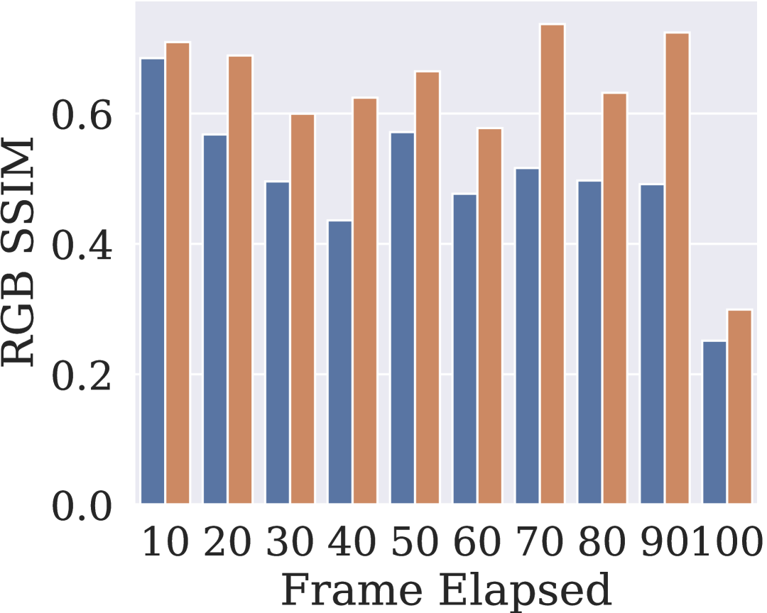
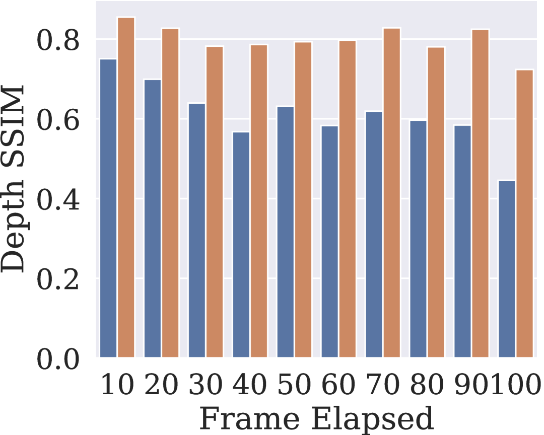
Accuracy evaluation. Next, we evaluate the quantitative accuracy of geometry-aware image warping with different camera depth data. For this experiment, we first select paired AR frame samples from ScanNet++ by randomly choosing frame pairs within a temporal window of frames, corresponding to milliseconds of time difference between frames. We use a step of 10 to find frames within the time window. This random pairing simulates view pose variations induced by user mobility in real-world AR usage. Using these paired frames, we then perform geometry-aware image warping under all three different depth inputs: (i) LiDAR depth, (ii) foundation model–predicted depth, and (iii) ground truth depth.
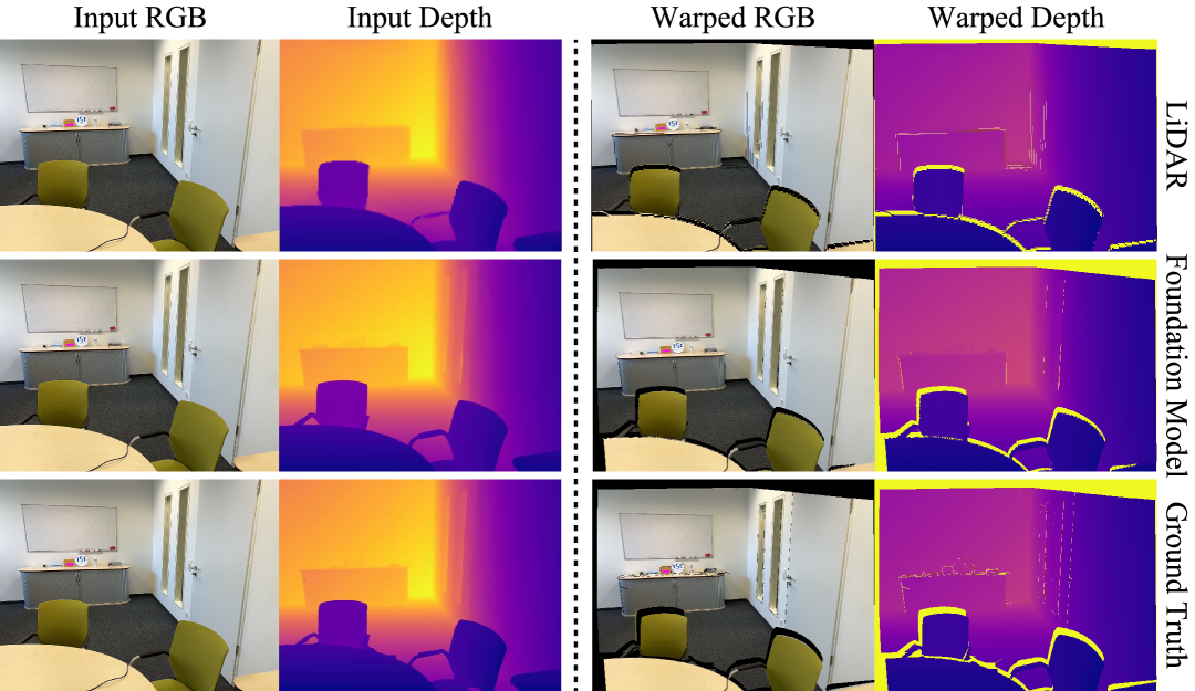
In Figure 2, we show a qualitative comparison of geometry-aware image warping using depth from foundation models, a LiDAR sensor, and the ground truth depth. For our experiment, we assume the environment does not change between views. We notice that not only does the foundation model generate more fine-grained depth details, but it also gives more accurate results on image edges and object boundaries. The improved depth quality translates to fewer visual artifacts and more accurate results on image warping. Consequently, the warping accuracy can enable more accurate reuse of sparse sensing results in real-time mobile AR.
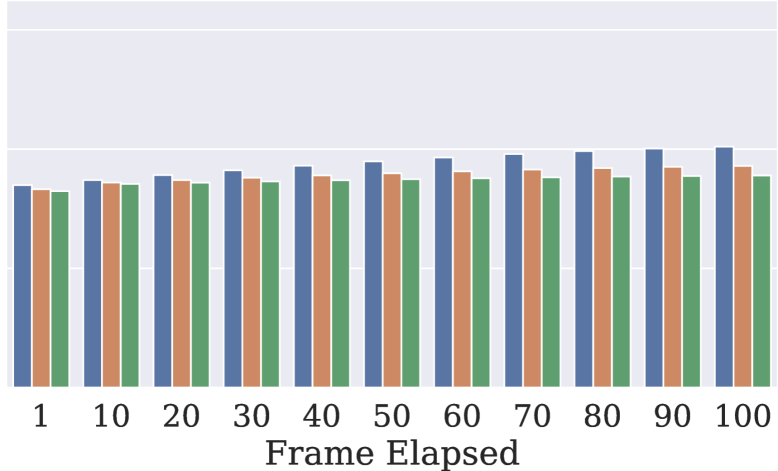
Figure 3 summarizes the quantitative results of geometry-aware image warping using different depth inputs. On average, warping with LiDAR depth achieves an SSIM of 0.499 for RGB images and 0.612 for depth images. Using the foundation model-estimated depth improves the SSIM to 0.626 and 0.800, respectively. This corresponds to an improvement of approximately 25.5% in RGB warping quality and 30.7% in depth warping quality. Furthermore, we observe that foundation model–based warping remains more robust over longer temporal intervals (i.e., larger frame gaps), whereas LiDAR depth-based warping typically degrades.

The observed improvements mainly come from the foundation model’s ability to generate depth maps with richer structural details and fewer artifacts. In particular, foundation depth estimation better captures object edges, fine surface variations, and subtle geometric discontinuities. LiDAR depth on these regions often becomes sparse or noisy due to limited resolution or reflective materials. These findings highlight the strong potential of foundation model–based depth estimation to improve both the accuracy and robustness of geometry-aware image warping. As a result, we expect the foundation depth model to be used to tackle camera movement and enable accurate cross-frame information reuse. It can also be used to enable high-latency sensing and perception algorithms in real-time applications by allowing the reuse of estimation results on temporally adjacent frames.
Summary. Foundation models significantly improve the geometry-aware image warping through more accurate depth estimation results. This brings a new opportunity to enable cross-frame information reuse and integrate sparse sensing in real-time mobile AR applications.
5. Long-Duration Sparse Sensing
Our previous experiment has shown promising results on employing a foundation model-based technique for sparse sensing of temporally adjacent frames. Next, we investigate the scalability of foundation-model-based sparse sensing in the context of 3D environment reconstruction tasks.

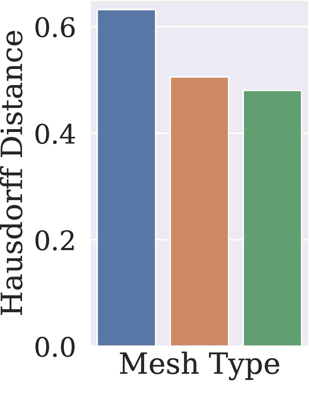
We evaluate the quality of reconstructing 3D environment meshes from long-duration AR session data. Using the session data from selected scenes, we first reconstruct 3D environment meshes using the device LiDAR depth. The LiDAR depth is from the dense AR frames. We reconstruct the environment mesh for each frame and merge them with three different methods: (i) simple concatenation, (ii) Poisson surface reconstruction (Kazhdan et al., 2006), and (iii) Poisson surface reconstruction combined with iterative closest point (ICP) (Besl and McKay, 1992) optimization. Next, we reconstruct the environment mesh using the foundation model-estimated depth on temporally downsampled frames. Similar to our previous experiment, we chose the frame gap from with a step of 10.
Figure 4 presents the average reconstruction accuracy of environment meshes across ten scenes using different mesh generation methods. We use Hausdorff Distance (Huttenlocher et al., 2002), which measures the distance between two subsets of the same metric space, to quantify the reconstruction accuracy. Specifically, in our case, we treat the overlapping region between the reconstructed and ground-truth meshes as the metric space. As shown in Figure 4a, applying advanced mesh merging algorithms leads to noticeable improvements in reconstruction quality for LiDAR depth-based methods. However, due to the inherent limitations in the quality of LiDAR depth, the overall reconstruction quality remains low. In contrast, the foundation model-based reconstruction can achieve significantly higher accuracy without advanced merging. Specifically, without temporal downsampling, the foundation depth-based Poisson + ICP reconstruction achieves a Hausdorff Distance of 0.25, whereas the LiDAR depth–based reconstruction yields 0.48. Moreover, we observe that the foundation model–based reconstruction remains robust under sparse input conditions. In Figure 4b, we notice consistently more accurate results even with significantly fewer inputs than the LiDAR-based reconstruction. These findings highlight the strong potential of foundation model–driven sparse sensing for enabling scalable 3D reconstruction tasks.
Summary. Our study suggests that foundation models can be leveraged to achieve better 3D reconstruction quality when using sparse sensing compared to directly using LiDAR-based per-frame depth information.
6. Towards Spatial-Temporal Sparse Sensing
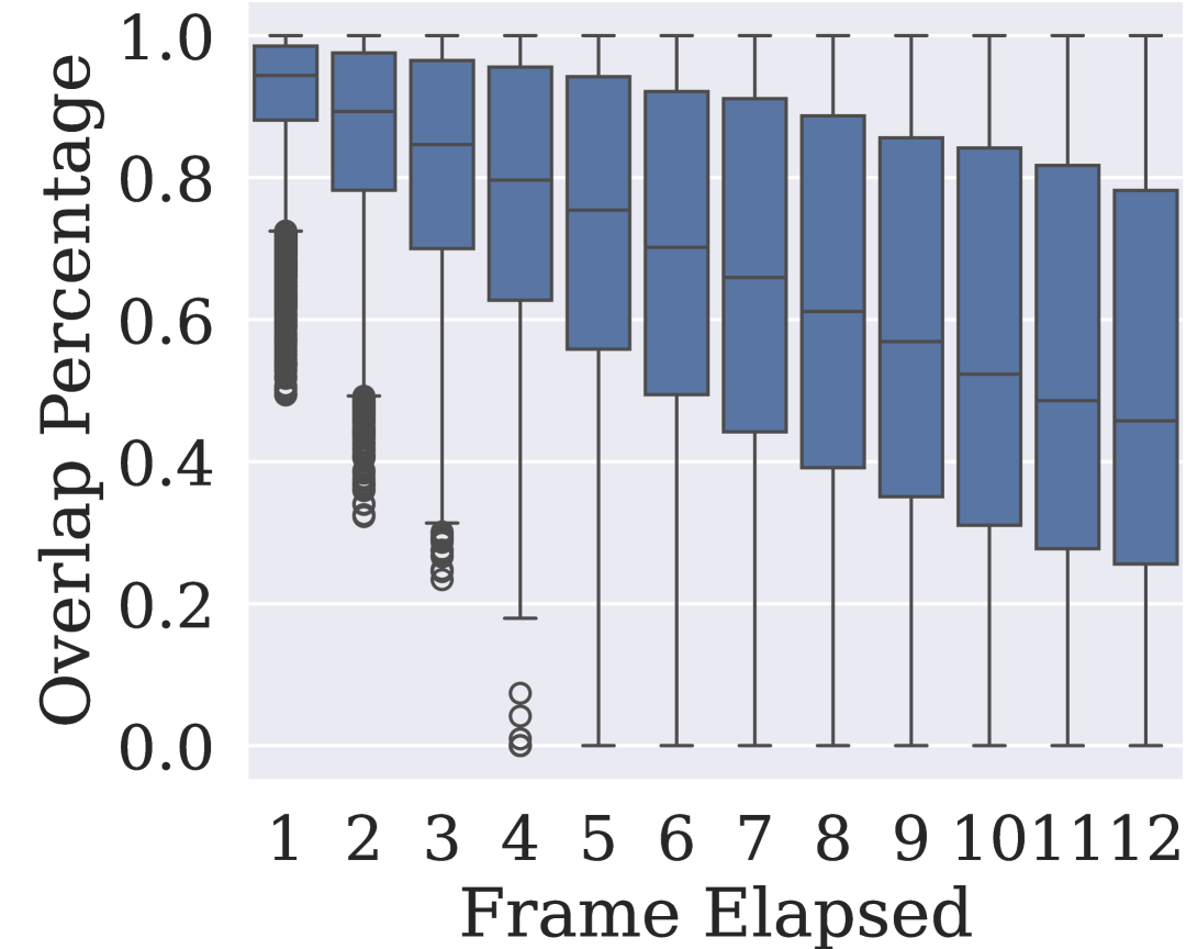
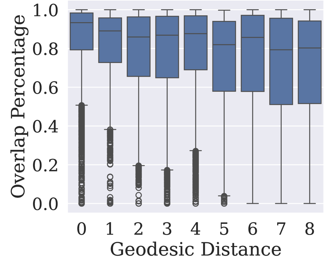
Although sparse sensing demonstrates great potential for both real-time and long-duration tasks, its effectiveness depends on well-designed control policies that ensure critical information is not missed during the sensing process. In this experiment, we analyze how information sparsity evolves under different sparse sensing control policies and explore the open questions and challenges for designing such policies. We quantify information sparsity by applying the geometry-aware image warping technique and measure the ratio of warped pixels. Different from motion-based analysis, this ratio captures both viewpoint changes and geometric variations in the environment.
We evaluate two categories of sparse sensing policies: (i) temporal sparse sensing, which reduces the sensing based on time intervals, and (ii) spatial sparse sensing, which reduces sensing based on device motion. For temporal sparsity, we vary the inter-frame interval to analyze how decreasing the framerate impacts information overlap. For spatial sparsity, we control camera motion based on the SE(3) geodesic distance. This metric, commonly used in 3D vision and SLAM (Triggs et al., 1999; Gao et al., 2023; Govindu, 2004), jointly accounts for both rotational and translational differences between camera poses.
Figure 5 shows our measurement results. For temporal sparse sensing, the information overlap degrades rapidly as the inter-frame interval increases. For example, maintaining an 80% information overlap requires at most four frames. This finding suggests that a 60 FPS AR stream can be temporally downsampled to 15 FPS, resulting in a 75% reduction in sensing workload, while still preserving sufficient inter-frame overlap for effective information reuse. A similar trend is observed under spatial sparse sensing. Combined with the geometry-aware image warping technique, this reduction opens up new opportunities for integrating foundation models into real-time AR pipelines at lower frame rates without compromising perceptual consistency.
However, it is important to note that neither temporal nor spatial control policies can strictly guarantee a minimum view-to-view overlap. This is because the information overlap is inherently influenced by user motion dynamics and environmental geometry. Furthermore, our measurements indicate that information sparsity evolves in a nonlinear manner, suggesting that static or heuristic policies may be insufficient for optimal performance. We believe future work should explore hybrid sparse sensing controllers that adapt to both user and environment context to allow intelligent reuse of information across frames to achieve high-quality sparse sensing in mobile AR.
Summary. Both temporal and spatial sparse sensing demonstrate high view overlaps, suggesting the promise of exploiting both domains when designing sparse sensing policies.
7. Conclusion
We take a first step toward a foundation model-driven sparse sensing for mobile AR systems. Through our study using real-world AR data, we showed that foundation models can compensate for reduced sensing frequency by more effectively reusing information across temporal and spatial domains, even improving 3D reconstruction quality under very sparsely sensed data. Our observations that downstream tasks can reuse information from both temporal and spatial domains in AR with the help of foundation models point toward a new class of sensing policy design, i.e., hybrid policies that truly adapt to user environment context and allow mobile devices to sense only when it matters.
References
- (1)
- Besl and McKay (1992) Paul J Besl and Neil D McKay. 1992. Method for registration of 3-D shapes. In Sensor fusion IV: control paradigms and data structures, Vol. 1611. Spie, 586–606.
- Chen et al. (2015) Zichong Chen, Juri Ranieri, Runwei Zhang, and Martin Vetterli. 2015. DASS: Distributed adaptive sparse sensing. IEEE Transactions on Wireless Communications 14, 5 (2015), 2571–2583.
- Donoho (2006) David L Donoho. 2006. Compressed sensing. IEEE Transactions on information theory 52, 4 (2006), 1289–1306.
- Du et al. (2020) Ruofei Du, Eric Turner, Maksym Dzitsiuk, Luca Prasso, Ivo Duarte, Jason Dourgarian, Joao Afonso, Jose Pascoal, Josh Gladstone, Nuno Cruces, Shahram Izadi, Adarsh Kowdle, Konstantine Tsotsos, and David Kim. 2020. DepthLab: Real-Time 3D Interaction With Depth Maps for Mobile Augmented Reality. In Proceedings of the 33rd Annual ACM Symposium on User Interface Software and Technology (UIST). ACM, 15 pages. doi:10.1145/3379337.3415881
- Duarte-Carvajalino and Sapiro (2009) Julio Martin Duarte-Carvajalino and Guillermo Sapiro. 2009. Learning to sense sparse signals: Simultaneous sensing matrix and sparsifying dictionary optimization. IEEE Transactions on Image Processing 18, 7 (2009), 1395–1408.
- Gao et al. (2023) Cong Gao, Anqi Feng, Xingtong Liu, Russell H Taylor, Mehran Armand, and Mathias Unberath. 2023. A fully differentiable framework for 2D/3D registration and the projective spatial transformers. IEEE transactions on medical imaging 43, 1 (2023), 275–285.
- Govindu (2004) Venu Madhav Govindu. 2004. Lie-algebraic averaging for globally consistent motion estimation. In Proceedings of the 2004 IEEE Computer Society Conference on Computer Vision and Pattern Recognition, 2004. CVPR 2004., Vol. 1. IEEE, I–I.
- Hu et al. (2024) Mu Hu, Wei Yin, Chi Zhang, Zhipeng Cai, Xiaoxiao Long, Hao Chen, Kaixuan Wang, Gang Yu, Chunhua Shen, and Shaojie Shen. 2024. A Versatile Monocular Geometric Foundation Model for Zero-shot Metric Depth and Surface Normal Estimation. (2024). arXiv:2404.15506
- Huttenlocher et al. (2002) Daniel P Huttenlocher, Gregory A. Klanderman, and William J Rucklidge. 2002. Comparing images using the Hausdorff distance. IEEE Transactions on pattern analysis and machine intelligence 15, 9 (2002), 850–863.
- Kazhdan et al. (2006) Michael Kazhdan, Matthew Bolitho, and Hugues Hoppe. 2006. Poisson surface reconstruction. In Proceedings of the fourth Eurographics symposium on Geometry processing, Vol. 7.
- Kong et al. (2023) Z Jonny Kong, Qiang Xu, Jiayi Meng, and Y Charlie Hu. 2023. AccuMO: Accuracy-centric multitask offloading in edge-assisted mobile augmented reality. In Proceedings of the 29th Annual International Conference on Mobile Computing and Networking. 1–16.
- Li et al. (2020) Mengtian Li, Yu-Xiong Wang, and Deva Ramanan. 2020. Towards streaming perception. In European conference on computer vision. Springer, 473–488.
- Meng et al. (2021) Jiayi Meng, Zhaoning Kong, Qiang Xu, and Y. Charlie Hu. 2021. Do Larger (More Accurate) Deep Neural Network Models Help in Edge-assisted Augmented Reality?. In Proceedings of the ACM SIGCOMM 2021 Workshop on Network-Application Integration (Virtual Event, USA) (NAI’21). Association for Computing Machinery, New York, NY, USA, 47–52. doi:10.1145/3472727.3472807
- Ravi et al. (2024) Nikhila Ravi, Valentin Gabeur, Yuan-Ting Hu, Ronghang Hu, Chaitanya Ryali, Tengyu Ma, Haitham Khedr, Roman Rädle, Chloe Rolland, Laura Gustafson, et al. 2024. Sam 2: Segment anything in images and videos. arXiv preprint arXiv:2408.00714 (2024).
- Razzaque and Dobson (2014) Mohammad Abdur Razzaque and Simon Dobson. 2014. Energy-efficient sensing in wireless sensor networks using compressed sensing. Sensors 14, 2 (2014), 2822–2859.
- Siméoni et al. (2025) Oriane Siméoni, Huy V Vo, Maximilian Seitzer, Federico Baldassarre, Maxime Oquab, Cijo Jose, Vasil Khalidov, Marc Szafraniec, Seungeun Yi, Michaël Ramamonjisoa, et al. 2025. Dinov3. arXiv preprint arXiv:2508.10104 (2025).
- Singh et al. (2022) Amanpreet Singh, Ronghang Hu, Vedanuj Goswami, Guillaume Couairon, Wojciech Galuba, Marcus Rohrbach, and Douwe Kiela. 2022. Flava: A foundational language and vision alignment model. In Proceedings of the IEEE/CVF Conference on Computer Vision and Pattern Recognition. 15638–15650.
- Triggs et al. (1999) Bill Triggs, Philip F McLauchlan, Richard I Hartley, and Andrew W Fitzgibbon. 1999. Bundle adjustment—a modern synthesis. In International workshop on vision algorithms. Springer, 298–372.
- Wang et al. (2004) Zhou Wang, Alan C Bovik, Hamid R Sheikh, and Eero P Simoncelli. 2004. Image quality assessment: from error visibility to structural similarity. IEEE transactions on image processing 13, 4 (2004), 600–612.
- Yang et al. (2015) Jing Yang, Xianwen Wu, and Jingxian Wu. 2015. Adaptive sensing scheduling for energy harvesting sensors with finite battery. In 2015 IEEE International Conference on Communications (ICC). IEEE, 98–103.
- Yeshwanth et al. (2023) Chandan Yeshwanth, Yueh-Cheng Liu, Matthias Nießner, and Angela Dai. 2023. Scannet++: A high-fidelity dataset of 3d indoor scenes. In Proceedings of the IEEE/CVF International Conference on Computer Vision. 12–22.
- Yuan et al. (2024) Jinliang Yuan, Chen Yang, Dongqi Cai, Shihe Wang, Xin Yuan, Zeling Zhang, Xiang Li, Dingge Zhang, Hanzi Mei, Xianqing Jia, et al. 2024. Mobile foundation model as firmware. In Proceedings of the 30th Annual International Conference on Mobile Computing and Networking. 279–295.
- Yuan et al. (2021) Lu Yuan, Dongdong Chen, Yi-Ling Chen, Noel Codella, Xiyang Dai, Jianfeng Gao, Houdong Hu, Xuedong Huang, Boxin Li, Chunyuan Li, et al. 2021. Florence: A new foundation model for computer vision. arXiv preprint arXiv:2111.11432 (2021).
- Zhao et al. (2025) Yiqin Zhao, Mallesham Dasari, and Tian Guo. 2025. Clear: Robust context-guided generative lighting estimation for mobile augmented reality. Proceedings of the ACM on Interactive, Mobile, Wearable and Ubiquitous Technologies 9, 3 (2025), 1–26.