Sensing, Detection and Localization for Low Altitude UAV: A RF-Based Framework via Multiple BSs Collaboration
Abstract
The rapid growth of the low-altitude economy has resulted in a significant increase in the number of Low, slow, and small (LLS) unmanned aerial vehicles (UAVs), raising critical challenges for secure airspace management and reliable trajectory planning. To address this, this paper proposes a cooperative radio-frequency (RF) detection and localization framework that leverages existing cellular base stations. The proposed approach features a robust scheme for LSS target identification, integrating a cell averaging-constant false alarm rate (CA-CFAR) detector with a micro-Doppler signature (MDS) based recognition method. Multi-station measurements are fused through a grid-based probabilistic algorithm combined with clustering techniques, effectively mitigating ghost targets and improving localization accuracy in multi-UAV scenarios. Furthermore, the Cramer-Rao lower bound (CRLB) is derived as a performance benchmark and reinforcement learning (RL)-based optimization is employed to balance localization accuracy against station resource usage. Simulations demonstrate that increasing from one to multiple BSs reduces the positioning error to near the CRLB, while practical experiments further verify the framework’s effectiveness. Furthermore, our RL-based optimization can find solutions that maintain high accuracy while minimizing resource usage, highlighting its potential as a scalable solution for ensuring airspace safety in the emerging low-altitude economy.
I Introduction
I-A Background and Motivation
Driven by the advancements in Unmanned aerial vehicle (UAV) technologies and supportive governmental policies, the low-altitude economy is experiencing rapid expansion from ground into the airspace. This growing promotes a wide range of emerging aerial applications, including logistics, emergency rescue, situation awareness, and environmental monitoring [1, 2, 3, 4, 5, 6, 7]. Concurrently, this trend is leading to an unprecedented increase in the number of UAVs, which introduces complex challenges to airspace management and flight safety [8, 9, 10].
On the one hand, diverse low-altitude services involve heterogeneous UAV types and mission requirements [11]. In the absence of interconnectivity among these applications, UAVs from different services can act as non-cooperative aerial obstacles. Their trajectories need to be accurately sensed, detected and localized to enable collision avoidance and improve flight efficiency [12], [13]. On the other hand, the extensive use of UAVs may raise the risk of unauthorized and non-cooperative drones operations, posing potential threats to public safety, such as terrorist attack, smuggling, and the disruptions to the normal operations of critical infrastructure like airports, military strongholds and large hydroelectric plants [14, 15, 16]. Consequently, there is a pressing need for robust and reliable UAV sensing, detection and localization technologies, which are not only vital to ensure secure and reliable low-altitude operations, but also essential for supporting the sustainable development of the low-altitude economy [17, 18, 19, 20, 21].
To achieve accurate detection accuracy, vision-based method have been investigated as mainstream UAV detection schemes [22]. However, their performance degrades in occluded and low-light environments. In contrast, radio frequency (RF)-based methods can work all-time and all-weather, making them priority alternatives for robust UAV detection [23], [24]. Generally, achieving high sensing, detection and localization accuracy in practice requires the deployment of numerous dedicated devices, which significantly increases infrastructure costs and prohibit their adoption in a short time [25]. Prompted by the advancement of millimeter wave and integrated sensing and communication (ISAC) technologies for the upcoming sixth-generation (6G) networks, sensing functions can be performed directly by base stations (BSs) without requiring additional equipments [26, 27, 28, 29, 30, 31]. Inspired by investigations of the ISAC applications for aerial scenarios, UAV sensing, detection and localization can be implemented using the current cellular networks, offering a cost-effective and scalable solution by unifying spectral resources and hardware platforms [32, 33, 34].
Despite the growing attention to UAV sensing, detection and localization via BSs, practical operations still faces several key limitations [35], [36], presented below.
-
•
UAVs in low-altitude applications are typically small targets, with a radar cross section (RCS) under 2, and their speeds are usually not exceeding 200. These characteristics classify them as low-slow-small (LSS) aerial targets, which are inherently difficult to distinguish from background clutter in urban environments, as they exhibit a low signal-to-clutter-plus-noise ratio and weak Doppler signatures [37, 38, 39].
- •
- •
These limitations highlight the urgent exploration for more advanced sensing, detection and localization frameworks of LLS targets within existing networks to meet the safety and reliability requirements of the emerging low-altitude economy.
Motivated by these challenges, this paper focuses on reliable UAV detection and localization by leveraging existing BSs, thereby reducing the need for costly dedicated sensing infrastructure. Utilizing the antenna array at the BS, the hybrid time of arrival (ToA) and angle of arrival (AoA) method can be employed to obtain ranging and angle information from the UAV using pilot or ISAC signals [46], [47]. To enhance the detection and localization performance of BSs, the inherent Doppler modulation caused by the rotation of UAV’s rotor, named micro-Doppler signature (MDS), can be exploited to obtain the more concentrated energy of LLS UAV targets [48] [49]. Furthermore, the cooperative scheme among multiple BSs and the efficient methods for processing multiple UAV targets recognition are necessary to be designed to eliminate ghost interference and enhance localization accuracy [50], which is the focus of this investigation.
I-B Related Works
UAV detection and localization by multiple stations can be briefly divided into three key phases [51]. The first is parameter estimation process, where localization-related information (e.g., distance and angle) is extracted from the received RF signals. The second phase involves clutter suppression and feature extraction operations, which are critical for mitigating interference from the environment and distinguishing UAV targets from noise and ghost reflections. The last stage is the cooperative data fusion process, where information from multiple stations is combined to refine the final position of the UAV and improve overall accuracy [52]. In the following, we overview the related works corresponding to each of these three stages.
For UAV detection and localization, the estimation process of UAV parameters is determined by the localization method. Common methods include ToA, AoA, received signal strength (RSS), and their combinations [53]. Generally, RSS is usually applied in indoor localization systems due to its feasibility and simplicity. However, it exhibits low accuracy in environments with significant fading or unknown pathloss coefficient [54, 55]. Conversely, ToA and AoA methods can provide relative higher accuracy distance measurements, especially for large bandwidth signals. Due to the synchronization issues, the ToA measurements can be further categorized into time difference of arrival (TDOA) and round trip measuring methods [56]. Different from traditional distributed multiple input multiple output (MIMO) radar system [57], the asynchronous problem has been effectively addressed in currently BS architectures. To fully utilize the capabilities of these BSs, the hybrid TOA and AOA is often adopted to locate the detected targets, which has been proven to yield excellent localization performance [58, 59, 60].
Clutters caused by the scatterers are the useless components in the received signals and must be suppressed. The key of clutter suppression is analyzing the property of clutter according to the relationship between scatterers and receiver systems [61]. For static reflectors and slow-moving clutter, benefited from the increased stability of digital processer, the moving target indicator (MTI) filters are effective at isolating targets with significant velocity [62]. However, for the dynamic LLS UAV targets with weak Doppler signatures, it is difficult to obtain high detection performance through the traditional detectors like constant false alarm rate (CFAR) [63] and adaptive normalized matched filter (AMF) [64]. To overcome this issue, method based on the MDS have been extensively investigated. Typically, the echo of rotor UAV mainly includes the translational component generated by the motion of UAV’s body and the micro-Doppler component generated by the rotation of rotor, whose echo is a typical sine frequency modulation (SFM) signal [65]. Therefore, by properly exploiting the micro-Doppler effects, target recognition can be significantly improved [66]. Generally, time-frequency analysis methods, such as short-time Fourier transform (STFT), radon-Wigner transform (RWT), etc., are used to generate the time-frequency spectrogram representing the MDS [67, 68]. Features are then extracted from these spectrograms using transition methods like singular value decomposition (SVD) [69], empirical mode decomposition (EMD) [70]. Subsequently, the LLS UAV can be detected using classification methods, such as support vector machines (SVM), and convolutional neural networks (CNN) [71], [72].
The multipath propagation generated by random reflectors or unexpected obstacles is another critical issue during detection process, especially in the complicated environment [73]. Compared to traditional long range detection, sensing inside the low-altitude scenarios suffers much more from the multipath effects, which leads to severe detection performance degradation and ghost targets generation [74]. Without proper priori knowledge of the environment, these ghosts could be mapped back to their corresponding true target location, which cause severe interference to the environmental sensing and mapping. Typically, two different ghost targets can be generated both from measurement procedure and data fusion phases, respectively. There may exist multipath ghosts produced by the indirect path propagations for an individual transmitter, with different bounce process from the reflector [75]. Additionally, multiple targets inside the beam intersection areas from multiple transmitter can also generate ghost detections [76]. These ghost targets will lead to unexpected false alarms, which has attracted wide interests [77, 78]. Consequently, various techniques for ghost suppression have been investigated. In [75], based on the phase property of multipath ghost, the phase coherent factor (PCF) was weighted to the radar image, to mitigate the ghost power. The authors in [79] found out the physical relationship among target, first-order ghost and second-order ghost. The Hough transform was applied to find out real target in range-Doppler domain. Machine learning based methods have also been adopted to recognize the ghost from measured observations. After training with the pre collected data from vehicle radar, the ghost can be distinguished successfully [80]. Building a cooperative sensor network is one of the most effective method to suppress ghost. The authors in [78] analyzed the aspect properties of ghost target, and introduced a sensor network with multiple monostatic radars to mitigate the ghost and realize indoor tracking. In [81], a distributed MIMO radar network was deployed, to sequentially separate the ghosts out.
The design of cooperative schemes, encompassing both the fusion method and node selection strategy, is also crucial for the detection and localization performance in a multiple-station network, especial for those resource limited scenarios. The geometric configuration of the participating station directly affects the detection and localization performance due to the difference in received signal intensity [82]. An straightforward method is to reduce the resource cost on BS nodes, to increase the positioning accuracy while conserving power and reducing interference between sensing communication [83]. Many investigations leverage the Cramer-Rao Lower Bound (CRLB), which provides a theoretical minimum for localization error, as a metric for optimizing the joint allocation of network resources like energy and spectrum [84] [85]. Nevertheless, the CRLB is not always achievable in low SNR conditions. To address this limitation, reinforcement learning (RL) based methods have been proposed. These approaches can optimize a non-closed-form localization metric, such as the mean square error (MSE) output by a specific algorithm, making them more practical for real-world scenarios with varying SNR [86], [87].
I-C Contribution
To address aforementioned challenges while fully leveraging current infrastructures, we propose a multi-layered, RF-based cooperative framework for UAV sensing, detection, and localization. Our approach begins with robust single-station sensing for LLS targets by combination methods of CA-CFAR detector and MDS based algorithm. Subsequently, measurements from multiple stations are intelligently fused using a grid-based probabilistic algorithm, which incorporates clustering to handle multi-UAV scenarios and effectively mitigate ghost targets. To improve the network efficiency, we introduce a RL-based optimization strategy that adaptively balances the localization accuracy and the number of involved stations. The main contributions of this paper are summarized as follows.
-
•
We first establish the framework for low altitude UAV sensing and detection, which is founded on a hybrid TOA and AOA localization method. The ghost types caused by indirect propagations are also analyzed comprehensively.
-
•
A CA-CFAR algorithm is then proposed to suppress clutters and obtain the ranging and angle information from received signals. The MDS-based methodology using EMD is employed to recognize the LLS UAV and further improve detection performance.
-
•
Subsequently, a clustering based method is provided in multi-UAV scenarios, where a probabilistic grid-based data fusion method is proposed to mitigate the ghost targets and enhance the localization accuracy.
-
•
The CRLB is derived analytically to illustrate the theoretical performance limits of this cooperative localization network. Two joint localization accuracy and node selection optimization problems are formulated and solved by RL-based algorithm to optimize the network efficiency. Numerical simulations and practical experiments are conducted to validate the superiority and feasibility of proposed framework.
The rest of this paper is organized as follows. Section II introduces the system model, detailing the measuring signal and ghost generation types. Section III presents algorithms of signal parameters estimation, MDS extraction and data fusion for UAV sensing, detection and localization, respectively. In section IV, the CRLB is derived, and two optimization problems are formulated and solved. Subsequently, simulation results and illustrated experiments are carried out in section V. Finally, Section VI draws the conclusion and key findings of this paper.
II System Model
II-A Scenario
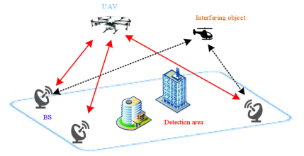
As depicted in Fig. 1, we consider a low-altitude surveillance scenario in the urban. There are BSs deployed to monitor a specific area of interest. Within this area, there may be one or more non-cooperative UAVs to be detected and localized. There are also some other unintentional moving objects (e.g., helicopters, birds) and a number of randomly located interactive objects, such as high buildings and other cooperative aerial devices. These interactive objects act as reflectors and are the primary source of multipath propagation, which can generate ghost echoes. Each BS attempts to detect and localize UAVs based on received echoes. The primary focus of this work is to recognize and locate the UAV by intelligently fusing the observations from all individual stations. The investigation is carried out based on the following key assumptions:
-
•
The received echoes at BSs may be generated by the UAV, unintentional targets, and randomly located interactive objects. The presence and location of interactive objects may vary over time due to the dynamic nature of the environment.
-
•
The interactive objects are treated as uncorrelated scatterers. For simplicity in modeling multipath, we primarily consider single-interaction bounces.
-
•
During the detection interval (a single coherent processing interval), the UAVs are assumed to be quasi-static, meaning their velocity is constant and their position does not change significantly.
II-B Signal Model
Generally, the received signal at the BS, superposed by the signals from UAVs and ghosts, can be expressed as
| (1) | ||||
where represents the transmitted signal, and is additive white Gaussian noise (AWGN). The first summation accounts for the echoes from the real UAVs, while the second part represents the echoes from the multipath ghosts in the environment. The term is the amplitude of the received signal from the -th scatterer, which is determined by the radar range equation and expressed as
| (2) |
Here, is the transmit power, and are the transmit and receive antenna gains, respectively, is the signal wavelength, and is the distance to the scatterer. The term indicates the RCS of the scatterer.
The term is time delay of the signal reflected from UAV , which is a function of its range and velocity. Assuming a UAV is at an initial distance from the BS and moving with a radial velocity , the two-way time delay can be expressed as
| (3) |
where is the speed of light in free space.
To enable angle estimation, we assume each BS is equipped with a uniform linear array (ULA) consisting of antenna elements. The signal received at the -th element of the array, , can be modeled based on the signal at the first element and a phase shift corresponding to the angle of arrival
| (4) |
where is the received signal at the first antenna element, and is the distance between adjacent antenna elements, and is the AoA of the signal from the UAV.
II-C Ghost Target Generation
In complex low-altitude environments, signals will propagate along multiple paths before returning to the receiver, leading to the generation of “ghost” targets, which are false detections.
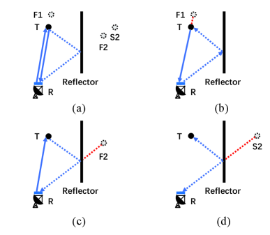
To illustrate the properties of multipath ghosts, we consider a detection scenario with one BS, one UAV, and one reflector, as shown in Fig. 2. The signal transmitted by the BS is assumed to be received by both the UAV and the reflector within its field of view (FoV). Ghosts are detected due to these indirect signal reflections. Based on the propagation path, these received signals can be categorized into the following types.
-
1.
Direct Path: As shown in Fig. 2(a), the direct or line-of-sight path follows the propagation BSUAVBS. This corresponds to the real detection of the UAV.
-
2.
Type-1 First-Order Ghost: This ghost involves a reflection off the reflector before the signal illuminates the UAV. As shown in Fig. 2(b), it experiences the propagation path BSReflectorUAVBS.
-
3.
Type-2 First-Order Ghost: This ghost, shown in Fig. 2(c), occurs when the signal reflects off the reflector after scattering from the UAV. The propagation path is BSUAVReflectorBS.
-
4.
Second-Order Ghost: Fig. 2(d) shows a second-order ghost, where both the transmitted and received signals bounce off the reflector. The path is BSReflectorUAVReflectorBS111If multiple reflectors exist, a signal may experience more than two indirect reflections. Generally, the energy of these higher-order ghosts is relatively small, making them less likely to be detected..
The detection probability of both the real UAV and the multipath ghosts is highly related to their signal-to-noise ratio (SNR) at the receiver. For the signal reflected from the direct path, the SNR is expressed as
| (5) |
where is the input power of signal from target UAV, is the noise power, is the output power from the transmitter, is the distance from the BS to the UAV, is the BS wavelength, is the non-fluctuating RCS of the UAV, and and are the antenna gains of the transmitter and receiver, respectively.
Conversely, the power of a signal received from an indirect path is lower than direct path due to the additional path loss and reflection losses. We typically only consider first-order ghosts, as higher-order ghosts have significantly lower energy. Assuming the distances from the reflector to the UAV and the BS are and respectively, and the RCS of the reflector is . Therefore, the SNR for an indirect path ghost can be expressed as
| (6) |
III UAV Detection and Localization Algorithm
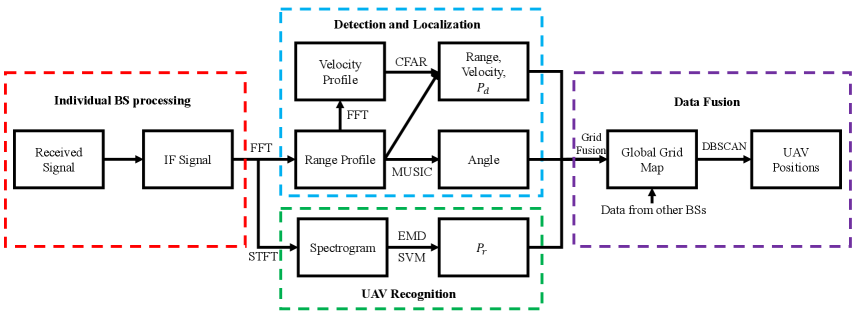
This section introduces the comprehensive process of our proposed UAV Detection and Localization framework, where the parameter estimation, MDS extraction, multi-station data fusion, are elaborated, respectively. The end-to-end workflow is illustrated in Fig. 3.
III-A Range, velocity and angle estimation
In this paper, we utilize the Linear Frequency Modulated Continuous Wave (LFMCW) as the transmitted signal , whose generation is compatible with the hardware capabilities of future BS, and is expressed as
| (7) |
where is the carrier frequency, is the linear modulation slope for a signal with bandwidth and duration , and is the amplitude. At each BS, the range, angle, and velocity of UAV are obtained from the received echoes through following signal processing steps.
III-A1 Intermediate Frequency (IF) Signal Generation
The IF signal is achieved by mixing the received echoes in (1) with a local copy of the transmitted signal. This process, known as de-chirping, shifts the echoes from different scatterers to baseband, where each scatterer’s echo becomes a sinusoidal tone. The resulting baseband IF signal is written as
| (8) | ||||
where represents the IF component corresponding to the -th scatterer, and is the mixer noise. The frequency of each IF component is proportional to the round-trip delay , which in turn encodes its range and velocity.
III-A2 IF Signal Digitalization
The analog IF signal is then sampled to produce a discrete-time signal. Denoting sampling period as , the sampling time is , where and represent the fast-time (for range) and slow-time (for velocity) domains, respectively. The discrete received signal is expressed as
| (9) |
This forms a matrix .
III-A3 Range Profile Generation
A range profile is generated by performing a Fast Fourier Transform (FFT) along the fast-time domain. A Hamming window is typically applied before the FFT to reduce sidelobes, which means the rang matrix
| (10) |
where is the windowing matrix and is the FFT matrix. Therefore, the range corresponding to the -th bin is estimated as
| (11) |
where is the sampling frequency.
III-A4 Velocity Profile Generation
Similarly, a velocity profile is obtained by performing an FFT across the slow-time domain, and is expressed as
| (12) |
The velocity corresponding to the -th bin is estimated as
| (13) |
III-A5 Range and Velocity Determination
Subsequently, a CA-CFAR detection strategy is adopted to distinguish UAV echoes from background noise in the range-velocity map [88]. The main steps are listed in Algorithm 1. A closed-form of the detection probability, for a specific UAV/ghost, can be achieved by calculating the probability that the signal envelope is over the detection threshold [89] as
| (14) |
where is the desired false alarm rate, and and are the number of reference cells in range and velocity.
III-A6 Angle Estimation
As established in the signal model, each BS is equipped with a ULA, allowing it to estimate the AoA of the signals reflected from a UAV. Off-the-shelf estimator as multiple signal classification (MUSIC) [90] can be used. The angle estimates for these two algorithms are expressed as
| (15) |
where is the noise subspace matrix and is the array steering vector. These estimated parameters including range, velocity, angle, and detection probability are then available for multi-BS fusion and further analysis.
III-B Micro-Doppler Feature Enhancement for UAV Recognition
While the CA-CFAR detector can identify the presence of moving objects, it cannot distinguish a UAV from other objects. To achieve robust UAV recognition, we leverage the unique MDS generated by the rotating blades of a UAV. These micro-motions produce a distinct frequency modulation on the reflected echo signal, which can be used as a feature for classification [91].

To model this effect, we consider a UAV with rotors. The echoes from a single rotor can be modeled as the coherent sum of reflections from its blades [92, 93]. The echo from one rotor can be expressed as
| (16) |
where is the length of a single blade. As shown in Fig. 4, is the distance from the rotor’s center of rotation to the BS, is the rotational angular frequency of the blade, and and are the azimuth and elevation angles of the rotor relative to the BS line-of-sight (LoS), respectively. The term represents the phase function of the -th blade. The total echo signal from the UAV is the sum of echoes from all its rotors,
| (17) |
To classify the UAV based on this signal, we employ a process involving EMD and a SVM classifier. The full procedure for acquiring the recognition probability , is described in Algorithm 2. A STFT is first applied to to generate a time-frequency spectrogram to represent the MDS. The EMD algorithm then decomposes the signal into a set of intrinsic mode functions (IMFs). Features such as zero-crossing rate, normalized energy, and standard deviation are extracted from the first four IMFs. These features form a vector that is fed into a pre-trained SVM classifier, which outputs the recognition probability . This probability quantifies the confidence that the detected object is indeed a UAV.
III-C Multi-Station Data Fusion for Localization
While a single BS can estimate the range, velocity, and angle of a UAV, its observations are susceptible to errors from noise, clutter, and multipath ghosts. To overcome these limitations and achieve robust, high-accuracy localization, we fuse observations from multiple spatially BSs. A grid-based probabilistic data fusion framework is proposed to reduce interference and enhances the reliability of the final localization. The process involves grid initialization and calibration, data fusion, and clustering.
III-C1 Grid Initialization and Calibration
The first step is to discretize the surveillance area into a grid and to map the local observations from each BS into this common, unified world coordinate system. This ensures that all measurements can be compared and combined meaningfully.
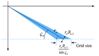
A critical aspect of this process is determining the size of the grid cells, which should be related to the resolution of the sensing BSs. For a given BS, a measurement corresponds not to an infinitesimal point but to a “possible detection region”, the size of which is determined by its range and angular resolution. As shown in Fig. 5, the size of this region for the -th BS is the minimum of its effective range and beam resolutions with
| (18) |
where and are defined as:
| (19) | ||||
| (20) |
Here, is the intrinsic range resolution (dependent on bandwidth), and is the 3dB beamwidth of the antenna, and is the measured range, and is the transmission angle. The final grid size for the entire map is chosen to be the minimum resolution across all participating BSs to avoid loss of information.
Once the grid is established, each local measurement is calibrated. Let the position of the -th BS in the world be =, with a rotation angle . If this BS detects a UAV at range and angle , the UAV’s world position, , is calculated as
| (27) |
This mapping allows us to translate every detection from its local polar coordinates to the corresponding grid cells in the global map.
III-C2 Data Fusion on a Grid Map
After calibration, the observations are fused on the grid map. This probabilistic approach combines information while filtering out inconsistent measurements, such as those from ghosts.
The event that grid cell is occupied by a UAV is defined as . When the -th BS receives an echo that maps to grid cell (event ), the posterior probability of the cell being occupied is updated using the Bayesian theorem as
| (28) |
The likelihood term is the recognition probability from the micro-Doppler analysis. This assigns higher likelihood to detections that exhibit UAV-like characteristics, effectively suppressing echoes from unintentional objects.
To combine observations from all BSs, we adopt a log-likelihood ratio probability fusion framework. For the -th BS, the occurrence probability of grid cell is updated iteratively
| (29) |
After iterating through all BSs, the final fused grid map contains enhanced probabilities for true UAV locations. The complete process is detailed in Algorithm 3. The final UAV position, , can then be estimated using a minimum mean square error (MMSE) as
| (30) |
where is the location of the -th grid cell.
III-C3 Clustering for Multiple UAVs
In scenarios with multiple UAVs, the fused grid map may contain several high-probability regions. To distinguish individual UAVs, we use the Density-Based Spatial Clustering of Applications with Noise (DBSCAN) method. DBSCAN groups high-probability grid cells into distinct clusters, each corresponding to a different UAV while identifying sparse noise points [94]. The algorithm is detailed in Algorithm 4.
IV Performance Analysis and Optimization
IV-A The Cramer-Rao Lower Bound
To evaluate the fundamental performance limits of the proposed multi-BS localization system, we utilize the CRLB, which provides a theoretical lower bound on the MSE for any unbiased estimator of a UAV’s position. According to the Fisher information inequality, the MSE of the position estimate, , is bounded as follows
| (31) |
where is the equivalent Fisher information matrix (EFIM) for the entire system [95]. The EFIM is constructed by aggregating the information from each antenna element of every participating BS. We can state the following proposition regarding its structure.
Proposition 1: If there are BSs deployed, and each BS is equipped with a -element uniform linear antenna array, the equivalent EFIM of the UAV’s position can be expressed as the sum of the individual information matrices from each antenna’s ToA and AoA measurements:
| (32) |
where and are the FIM for the ToA and DoA measurements, respectively, from the -th antenna element of the -th BS.
Proof: The detailed derivation of the Fisher Information Matrix is provided in the Appendix.
This proposition highlights two key remarks.
-
•
At each individual BS, the measurement information obtained from ToA () and DoA () can be linearly accumulated. The quality of this information is determined by system parameters such as transmit power and signal bandwidth, as well as the geometric relationship between the BS and the UAV.
-
•
The measurement information from multiple BSs can also be linearly accumulated. This demonstrates that observations from all BSs can be combined to achieve a more accurate and reliable position estimate compared to what is possible with a single BS.
The CRLB serves as an essential performance benchmark, allowing us to quantify how close the accuracy of our proposed fusion and localization algorithms comes to the theoretical best-case scenario.
IV-B Reinforcement Learning for Station Selection
In a dense network of BSs, it is often inefficient and unnecessary to activate all of them for UAV detection. Activating only the most useful BSs can significantly reduce energy consumption and computational load while maintaining or even improving localization accuracy. This section formulates the BS selection task as an optimization problem and presents a RL-based solution. We first consider a single UAV scenario and then extend the framework to handle multiple UAVs.
IV-B1 Single UAV Scene
Problem Formulation
For a single UAV scene with a total of available BSs, our objective is to select a subset of these BSs to find a balance between minimizing the localization MSE and the resource cost (number of active BSs). With the true position of the UAV being and the estimated position being , the MSE is . The optimization problem can then be written as
| (33) | ||||
| s.t. | ||||
where is the selection vector, with indicating that the -th BS is selected. is the total number of selected BSs. and are the weighting factors for the MSE and resource cost, respectively. Since the MSE cannot be easily formulated as a closed-form function of the BS selection state , we adopt a non-parametric, model-free learning strategy.
Node Selection Strategy
We employ Q-learning to find an optimal policy for BS selection. The Q-learning framework is defined within a Markov Decision Process (MDP) as follows:
-
•
Agent: The agent is the BS sensor network responsible for positioning.
-
•
State: The state is the power allocation status for all BSs, represented by a binary vector indicating which BSs are currently active (on/off).
-
•
Action: An action is the decision to change the state, i.e., to select a new subset of BSs to activate for the next measurement.
-
•
Environment: The environment is the physical space containing the UAV. The agent’s interaction with the environment yields an observation, which is the localization result obtained using the fusion framework from the previously selected BSs.
The Q-learning algorithm iteratively updates a Q-table, which estimates the long-term reward of taking a certain action from a given state. The agent explores different selection strategies using an -greedy policy. The reward function is designed to reflect the objective function
| (34) |
where is a constant baseline reward. By maximizing this reward, the agent learns to select BS configurations that result in a good trade-off between positioning error and resource cost. The complete training and regression process is outlined in Algorithm 5. To improve real-time performance, a pre-trained Back Propagation (BP) neural network can be used to approximate the Q-function, enabling rapid selection of the sub-optimal action based on a coarse initial UAV position estimate.
IV-B2 Multi-UAV Scene
General Extension
When multiple UAVs are present, the objective function is modified to account for the localization error of all UAVs. The optimization problem, , becomes minimizing the sum of weighted MSEs and the resource cost
| : min | (35) | |||
| s.t. | ||||
To satisfy this requirement, the reward function in the Q-learning algorithm must be adjusted to reflect this new objective.
Suboptimal Scheme
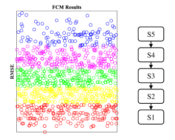
Optimizing for multiple UAVs simultaneously can be complex. A practical, suboptimal approach is to define states based on localization performance. As shown in Fig. 6, we can define a finite number of states based on the distribution of the Root Mean Square Error (RMSE) using a clustering method like Fuzzy C-Means (FCM). The agent learns to select actions that move the system from poor states (e.g., S1) to good states (e.g., S5). The RL agent’s goal is then to take actions that transition the system from a high-error state to a low-error state.
The problem can be reformulated to find the minimum number of BSs, , that can achieve a localization MSE below a certain threshold, , for all detected UAVs
| : min | (36) | |||
| s.t. |
The Q-learning algorithm is then trained to satisfy this constraint. The state transitions from poor localization (high error) to accurate localization (error below ), and the algorithm stops when the error constraint is met, yielding an efficient BS selection.
V Experimental and Simulation Results
V-A Numerical Simulations
To validate the performance of the proposed framework, we conduct a series of numerical simulations. We first describe the simulation setup and then present the results for collaborative localization and reinforcement learning-based BS selection.
V-A1 Simulation Settings
As shown in Fig. 7, the simulation environment consists of a area with a grid resolution of . Two UAVs with different micro-Doppler characteristics are randomly located: “target UAV” (e.g., a quadcopter) and an “unintentional UAV” (e.g., a larger, helicopter-like UAV). 8 BSs are deployed at the edges of the map, each separated by . All BSs are assumed to be synchronized.
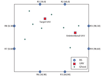
To simulate a complex environment, reflectors are randomly distributed according to a Poisson Point Process (PPP) with an expectation of 3, which generate multipath ghost echoes. The key simulation parameters for the BSs are listed in Tab. I.
| Parameter | Value | Parameter | Value |
| Carrier Frequency () | 24 GHz | Bandwidth () | 100 MHz |
| Pulse Duration () | 1 ms | Samples () | 128 |
| Number of Pulses () | 64 | 0.001 |
V-A2 Localization Results
The simulated localization process is presented in Fig. 8, where the color map represents the detection probability. The process demonstrates the progressive refinement from raw single-BS data to a precise, fused localization result.
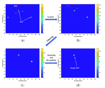
Single BS Detection
Initially, we evaluate the performance of a single BS (located at R1 in Fig. 7). As shown in Fig. 8 (a), the single BS generates a probabilistic map containing multiple potential detections. It is unable to distinguish the true UAVs from the multipath ghosts, highlighting the challenge of localization in complex environments.
Observations from Multiple BSs
Next, we apply the proposed data fusion framework to combine observations from all eight BSs. By comparing Fig. 8 (a) and Fig. 8(b), it is clear that the fusion process significantly enhances the detection probabilities at the true UAV locations while suppressing the probabilities of the inconsistent ghost detections. By applying a threshold (set to half the peak probability value), the influence of multipath reflections is almost entirely mitigated, as shown in Fig. 8(c). Finally, by applying the DBSCAN clustering and micro-Doppler recognition algorithms, the target of interest is successfully isolated and localized, as shown in Fig. 8 (d).
Performance Analysis
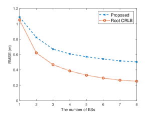
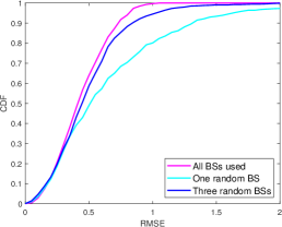
To quantitatively assess the performance, we conducted 5000 Monte Carlo simulations. Fig. 9 shows the mean positioning error (MMSE) as a function of the number of active BSs, compared against the theoretical CRLB. The results clearly show that the localization error decreases as more BSs are used, demonstrating the benefit of collaborative sensing. The cumulative distribution function (CDF) of the positioning error, shown in Fig. 10, further illustrates that using all eight BSs provides a significant improvement over using a single or a small number of BSs.
V-A3 Node Selection Results
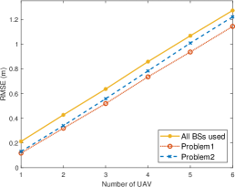
We now evaluate the performance of the reinforcement learning-based BS selection algorithms, considering both the single-UAV objective () and the multi-UAV objective (). We performed 2000 training iterations followed by 2000 Monte Carlo simulations, varying the number of UAVs from one to six.
RMSE Performance
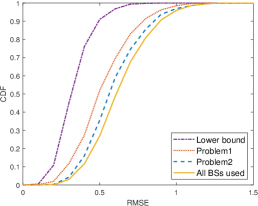
Fig. 11 shows the total localization error versus the number of UAVs for three cases: using all BSs, using the optimization, and using the optimization. Both optimization methods outperform the baseline of using all BSs. The method achieves the lowest error, while the method still offers a significant improvement of nearly 0.4 meters over the baseline. The CDF of the localization error for a three-UAV scenario is shown in Fig. 12, confirming that both optimization methods yield better performance than the baseline, though they remain above the theoretical lower bound due to the inclusion of resource cost in the reward function.
V-B Practical Experiments
In addition to simulations, we conducted practical experiments to validate the proposed framework in a real-world indoor environment. The experiments demonstrate the effectiveness of both the micro-Doppler based UAV recognition and the multi-BS data fusion for improving localization accuracy.
V-B1 Experimental Setup
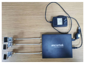
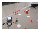
The experiments were carried out using a K-band (24 GHz) FMCW radar kit (Ancortek SDR-kit 2400AD2), as shown in Fig. 13(a). The radar is capable of generating the necessary waveforms for sensing and is equipped with one transmit and two receive horn antennas, allowing for both ToA and AoA measurements as described in Section IV-A.
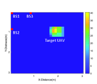
The experimental scene, depicted in Fig. 13(b), was set up in a cluttered indoor environment containing various stationary objects like chairs and desks. Two distinct objects were used for the experiment: a target of interest, represented by an electric fan to emulate the rotating blades of a UAV, and an unintentional object, a stationary iron box.
To simulate a multi-BS scenario, the radar was placed at three different locations sequentially. The data from each location was recorded and then processed as if it were collected simultaneously from three separate, spatially distributed BSs.
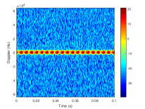
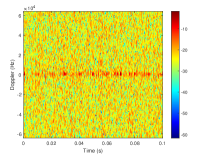
V-B2 Micro-Doppler Characterization
First, we analyzed the micro-Doppler signatures of the fan (UAV) and the iron box to verify the recognition capability of our system. Figure. 14 shows the time-frequency spectrograms for both objects.
A clear difference is visible: the fan’s rotating blades produce a distinct periodic micro-Doppler signature, whereas the iron box, being stationary, exhibits no such features. We applied the EMD-SVM classifier described in Section IV-B to these signals. The resulting recognition probabilities () are shown in Tab. II. The classifier correctly identifies the fan as a UAV with high probability (0.8 to 0.93) across all three BS locations, while assigning a very low probability to the iron box. This confirms that the proposed feature enhancement method can effectively distinguish UAVs from other static or unintentional objects.
| BS 1 | BS 2 | BS 3 | |
|---|---|---|---|
| Fan (UAV) | 0.8 | 0.8667 | 0.9333 |
| Iron Box | 0.2667 | 0 | 0.2 |
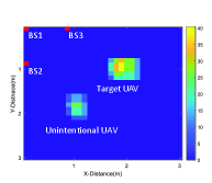
V-B3 Multi-BS Fusion and Localization
Next, we evaluated the performance of the multi-BS data fusion framework. Figure 15(a) shows the fused detection map using the basic detection probability () from all three BS locations. While both the fan (target of interest) and the iron box (unintentional target) are detected, the map is noisy.
Figure 15(b) shows the result after applying our complete framework, where the fusion is weighted by the recognition probability (). The framework successfully suppresses the detection of the iron box and isolates the fan, providing a clean and unambiguous localization of the UAV.
The positioning errors for individual BSs and various fused combinations are listed in Tab. III. The results show that fusing observations from multiple BSs provides a more ”balanced” and often more accurate solution. For instance, while BS 2 has the lowest individual error, BS 1 and BS 3 have significant errors. Fusing all three BSs yields a final error of 0.0627 m, which is a substantial improvement over the average individual performance. This demonstrates that multi-BS observations provide spatial diversity that effectively mitigates multipath effects and improves overall detection accuracy and reliability.
| Error | Mean | |
|---|---|---|
| BS 1 | 0.0333 | |
| BS 2 | 0.1414 | 0.1249 |
| BS 3 | 0.2000 | |
| BS 1 and 2 | 0.0505 | |
| BS 1 and 3 | 0.0514 | 0.0836 |
| BS 2 and 3 | 0.1490 | |
| All three BSs | 0.0627 | |
VI Conclusion
In this paper, we investigated UAV sensing, detection and localization in the context of the emerging low-altitude economy, where the proliferation of LSS UAVs poses significant safety challenges. To address the limitations of conventional solutions, we proposed an RF-based cooperative sensing framework that leverages existing base stations, integrating CA-CFAR and MDS-based methods for robust UAV detection and recognition. A grid-based probabilistic data fusion and clustering strategy was introduced to mitigate ghost targets and improve multi-UAV localization accuracy. Furthermore, CRLB analysis and RL-based optimization were employed to balance localization performance and system efficiency. The feasibility and superiority of the proposed framework are verified through both numerical simulations and practical experiments. Our method is shown to reduce localization error by over through multi-station fusion, a result confirmed by experiments achieving centimeter-level accuracy, while our RL-based optimization efficiently manages network resources. Future work will extend the framework to more complex communication scenario and explore the co-design strategies between sensing and communication for large-scale UAV networks.
Appendix: Proof of Proposition 1
The measurement equation for the position of a UAV, , as observed by BSs, each with antennas, is given by the vector of observations :
| (53) |
where and are the measured range and angle. The true range and angle, and , are functions of the UAV’s position and the antenna’s position :
| (54) |
| (55) |
The measurement noise vector is zero-mean Gaussian with covariance . The likelihood function is:
| (56) |
where and are the measurement errors, and represents the constant terms from the likelihood function’s normalization factor, which will not influence the subsequent derivatives with respect to . The log-likelihood function is:
| (57) |
The first-order partial derivative of the log-likelihood is:
| (58) |
The second-order partial derivative is:
| (59) |
where
| (60) |
| (61) |
The Fisher Information Matrix (FIM) is the negative expectation of the second-order derivative. Since the expectation of the error terms and is zero, the second terms in and vanish.
| (62) |
The partial derivatives of the range and angle functions are:
| (63) |
| (64) |
The outer product for the ToA component is:
| (65) |
And the outer product for the AoA component is:
| (66) |
Substituting these results back into the FIM expression yields the final form:
| (67) |
References
- [1] H. Huang, J. Su, and F.-Y. Wang, “The potential of low-altitude airspace: The future of urban air transportation,” IEEE Transactions on Intelligent Vehicles, 2024.
- [2] D. He, W. Yuan, J. Wu, and R. Liu, “Ubiquitous UAV communication enabled low-altitude economy: Applications, techniques, and 3gpp’s efforts,” IEEE Network, 2025.
- [3] Y. Ping, T. Liang, H. Ding, G. Lei, J. Wu, X. Zou, K. Shi, R. Shao, C. Zhang, W. Zhang et al., “Multimodal large language models-enabled UAV swarm: Towards efficient and intelligent autonomous aerial systems,” arXiv preprint arXiv:2506.12710, 2025.
- [4] Q. Wu, J. Xu, Y. Zeng, D. W. K. Ng, N. Al-Dhahir, R. Schober, and A. L. Swindlehurst, “A comprehensive overview on 5G-and-beyond networks with UAVs: From communications to sensing and intelligence,” IEEE Journal on Selected Areas in Communications, vol. 39, no. 10, pp. 2912–2945, 2021.
- [5] T. Liang, T. Zhang, and Q. Zhang, “Toward seamless localization and communication: A Satellite-UAV NTN architecture,” IEEE Network, vol. 38, no. 4, pp. 103–110, 2024.
- [6] T. Liang, W. Liu, J. Yang, and T. Zhang, “Age of information based scheduling for UAV aided emergency communication networks,” in ICC 2022 - IEEE International Conference on Communications, 2022, pp. 5128–5133.
- [7] T. Liang, T. Zhang, Q. Wu, W. Liu, D. Li, Z. Xie, D. Li, and Q. Zhang, “Age of information based scheduling for UAV aided localization and communication,” IEEE Transactions on Wireless Communications, vol. 23, no. 5, pp. 4610–4626, 2024.
- [8] P. Pothana, J. Joy, P. Snyder, and S. Vidhyadharan, “Uas air-risk assessment in and around airports,” in 2023 Integrated Communication, Navigation and Surveillance Conference (ICNS), 2023, pp. 1–11.
- [9] J. Yang, Y. Wang, X. Hang, and D. Delahaye, “A review on airspace design and risk assessment for urban air mobility,” IEEE Access, vol. 12, pp. 157 599–157 611, 2024.
- [10] W. Yuan, C. Liu, F. Liu, S. Li, and D. W. K. Ng, “Learning-based predictive beamforming for UAV communications with jittering,” IEEE Wireless Communications Letters, vol. 9, no. 11, pp. 1970–1974, 2020.
- [11] H. Jin, W. Yuan, J. Wu, J. Wang, D. Niyato, X. Wang, G. K. Karagiannidis, Z. Lin, Y. Gong, D. I. Kim et al., “Advancing the control of low-altitude wireless networks: Architecture, design principles, and future directions,” arXiv preprint arXiv:2508.07967, 2025.
- [12] Y. Wang, K. Zu, L. Xiang, Q. Zhang, Z. Feng, J. Hu, and K. Yang, “Isac enabled cooperative detection for cellular-connected UAV network,” IEEE Transactions on Wireless Communications, vol. 24, no. 2, pp. 1541–1554, 2025.
- [13] J. Wu, W. Yuan, Q. Cheng, and H. Jin, “Toward dual-functional LAWN: Control-aware system design for aerodynamics-aided UAV formations,” arXiv preprint arXiv:2507.19910, 2025.
- [14] A. P. Cohen, S. A. Shaheen, and E. M. Farrar, “Urban air mobility: History, ecosystem, market potential, and challenges,” IEEE Transactions on Intelligent Transportation Systems, vol. 22, no. 9, pp. 6074–6087, 2021.
- [15] C. Dong, Y. Wang, W. Wang, X. Zhu, M. Zhang, and Q. Wu, “Low-altitude centric space-air-ground integrated network: Evolutions, challenges and countermeasures,” IEEE Internet of Things Journal, pp. 1–1, 2025.
- [16] X. Huang, Z. Wang, Q. Peng, H. Xu, and Z. He, “LSS UAV target intelligent detection in urban complex environment,” in 2021 IEEE 3rd International Conference on Civil Aviation Safety and Information Technology (ICCASIT), 2021, pp. 648–650.
- [17] G. Lei, T. Liang, Y. Ping, X. Chen, L. Zhou, J. Wu, X. Zhang, H. Ding, X. Zhang, W. Yuan et al., “Enhancing low-altitude airspace security: Mllm-enabled UAV intent recognition,” arXiv preprint arXiv:2509.06312, 2025.
- [18] Z. Li, Z. Gao, K. Wang, Y. Mei, C. Zhu, L. Chen, X. Wu, and D. Niyato, “Unauthorized UAV countermeasure for low-altitude economy: Joint communications and jamming based on MIMO cellular systems,” IEEE Internet of Things Journal, vol. 12, no. 6, pp. 6659–6672, 2025.
- [19] M. Liu, H. Xiao, G. Pan, J. Zhou, W. Li, and X. Xi, “How to achieve large-scale development in the low-altitude economy,” in 2024 IEEE 10th International Symposium on Microwave, Antenna, Propagation and EMC Technologies for Wireless Communications (MAPE), 2024, pp. 1–4.
- [20] T. Liang, T. Zhang, S. Zhou, W. Liu, D. Li, and Q. Zhang, “UAV-aided localization and communication: Joint frame structure, beamwidth, and power allocation,” IEEE Journal of Selected Areas in Sensors, vol. 1, pp. 154–165, 2024.
- [21] T. Liang, H. Ding, Y. Ping, T. Zhang, L. Zhou, Q. Zhang, and T. Q. S. Quek, “Satellite-assisted uav control: Sensing and communication scheduling for energy efficient data collection,” IEEE Internet of Things Journal, pp. 1–1, 2025.
- [22] R. Niu, Y. Qu, and Z. Wang, “UAV detection based on improved yolov4 object detection model,” in 2021 2nd International Conference on Big Data & Artificial Intelligence & Software Engineering (ICBASE), 2021, pp. 25–29.
- [23] Z. Wang, Z. Cao, J. Xie, W. Zhang, and Z. He, “Rf-based drone detection enhancement via a generalized denoising and interference-removal framework,” IEEE Signal Processing Letters, vol. 31, pp. 929–933, 2024.
- [24] M. Ezuma, F. Erden, C. Kumar Anjinappa, O. Ozdemir, and I. Guvenc, “Detection and classification of UAVs using rf fingerprints in the presence of wi-fi and bluetooth interference,” IEEE Open Journal of the Communications Society, vol. 1, pp. 60–76, 2020.
- [25] W. Xie, Y. Wan, G. Wu, Y. Li, F. Zhou, and Q. Wu, “An RF-Visual directional fusion framework for precise UAV positioning,” IEEE Internet of Things Journal, vol. 11, no. 22, pp. 36 736–36 747, 2024.
- [26] W. Yuan, Z. Wei, S. Li, J. Yuan, and D. W. K. Ng, “Integrated sensing and communication-assisted orthogonal time frequency space transmission for vehicular networks,” IEEE Journal of Selected Topics in Signal Processing, vol. 15, no. 6, pp. 1515–1528, 2021.
- [27] M. Jia, J. Yang, and T. Zhang, “Power allocation in infrastructure limited integration sensing and localization wireless networks,” in 2022 IEEE 96th Vehicular Technology Conference (VTC2022-Fall), 2022, pp. 1–5.
- [28] F. Liu, W. Yuan, C. Masouros, and J. Yuan, “Radar-assisted predictive beamforming for vehicular links: Communication served by sensing,” IEEE Transactions on Wireless Communications, vol. 19, no. 11, pp. 7704–7719, 2020.
- [29] F. Liu, Y. Cui, C. Masouros, J. Xu, T. X. Han, Y. C. Eldar, and S. Buzzi, “Integrated sensing and communications: Toward dual-functional wireless networks for 6G and beyond,” IEEE journal on selected areas in communications, vol. 40, no. 6, pp. 1728–1767, 2022.
- [30] H. He, T. Liang, and T. Zhang, “Robust beamforming for isac systems in highly dynamic scenarios,” in 2023 IEEE 34th Annual International Symposium on Personal, Indoor and Mobile Radio Communications (PIMRC), 2023, pp. 1–6.
- [31] X. Zhang, W. Yuan, C. Liu, J. Wu, and D. W. K. Ng, “Predictive beamforming for vehicles with complex behaviors in ISAC systems: A deep learning approach,” IEEE Journal of Selected Topics in Signal Processing, vol. 18, no. 5, pp. 828–841, 2024.
- [32] Z. Yan, W. Yuan, X. Zhang, C. Liu, J. Wu, and T. Q. Quek, “Deep learning-based compensation mechanism for UAV sensing via OTFS signaling,” IEEE Internet of Things Journal, 2025.
- [33] J. Wu, W. Yuan, X. Zhang, Y. Yu, Y. Cui, F. Liu, G. Sun, J. Wang, D. Niyato, and D. I. Kim, “Toward multi-functional LAWNs with ISAC: Opportunities, challenges, and the road ahead,” arXiv preprint arXiv:2508.17354, 2025.
- [34] J. Wu, W. Yuan, and L. Hanzo, “When UAVs meet ISAC: Real-time trajectory design for secure communications,” IEEE Transactions on Vehicular Technology, vol. 72, no. 12, pp. 16 766–16 771, 2023.
- [35] Y. Zhao and Y. Su, “Estimation of micro-doppler parameters with combined null space pursuit methods for the identification of LSS UAVs,” IEEE Transactions on Geoscience and Remote Sensing, vol. 61, pp. 1–11, 2023.
- [36] P. Zhu, L. Wen, D. Du, X. Bian, H. Fan, Q. Hu, and H. Ling, “Detection and tracking meet drones challenge,” IEEE Transactions on Pattern Analysis and Machine Intelligence, vol. 44, no. 11, pp. 7380–7399, 2022.
- [37] Q. Wang, X. Wei, and M. Gao, “Lssdnet: A low-slow-small target detection method based on centimeter wave radar in the urban environment,” IEEE Sensors Journal, vol. 25, no. 12, pp. 22 118–22 137, 2025.
- [38] A. A. Selvi and S. P. K. Babu, “Design and simulation of an FMCW/CW X-Band radar for detection/classification of LSS targets,” in 2025 International Conference on Wireless Communications Signal Processing and Networking (WiSPNET), 2025, pp. 1–6.
- [39] W. Yuan, X. Chen, X. Du, J. Guan, J. Wang, and T. Lan, “A low slow small target classification network model based on k-band radar dynamic multifeature data fusion,” IEEE Sensors Journal, vol. 25, no. 1, pp. 1656–1668, 2025.
- [40] Y. Ahirrao, R. P. Yadav, and S. Kumar, “Real-time UAV detection through RF signal analysis and machine learning,” in 2024 IEEE Microwaves, Antennas, and Propagation Conference (MAPCON), 2024, pp. 1–4.
- [41] R. Akter, V.-S. Doan, A. Zainudin, and D.-S. Kim, “Sparsely connected low complexity CNN for unmanned vehicles detection-sensing RF signal,” IEEE Transactions on Vehicular Technology, vol. 73, no. 10, pp. 14 236–14 251, 2024.
- [42] B. Gao, M. Jia, T. Zhang, and Q. Zhang, “Reliable target positioning in complicated environments using multiple radar observations,” in 2021 IEEE Global Communications Conference (GLOBECOM), 2021, pp. 1–6.
- [43] R. Feng, E. De Greef, M. Rykunov, H. Sahli, S. Pollin, and A. Bourdoux, “Multipath ghost recognition for indoor MIMO radar,” IEEE Transactions on Geoscience and Remote Sensing, pp. 1–10, 2021.
- [44] X. Wang, M. Jia, X. Meng, and T. Zhang, “Multipath ghosts mitigation for radar-based positioning systems,” in 2022 IEEE 96th Vehicular Technology Conference (VTC2022-Fall), 2022, pp. 1–6.
- [45] F. Kraus, N. Scheiner, W. Ritter, and K. Dietmayer, “The radar ghost dataset: An evaluation of ghost objects in automotive radar data,” in 2021 IEEE/RSJ International Conference on Intelligent Robots and Systems (IROS), 2021, pp. 8570–8577.
- [46] D. Ghozlani, A. Omri, S. Bouallegue, H. Chamkhia, and R. Bouallegue, “Stochastic geometry-based analysis of joint radar and communication-enabled cooperative detection systems,” in 2021 17th International Conference on Wireless and Mobile Computing, Networking and Communications (WiMob), 2021, pp. 325–330.
- [47] J. Yang, T. Zhang, X. Wu, T. Liang, and Q. Zhang, “Efficient scheduling in space-air-ground-integrated localization networks,” IEEE Internet of Things Journal, vol. 9, no. 18, pp. 17 689–17 704, 2022.
- [48] G. Ji, C. Song, and H. Huo, “Detection and identification of low-slow-small rotor unmanned aerial vehicle using micro-doppler information,” IEEE Access, vol. 9, pp. 99 995–100 008, 2021.
- [49] Y. Sun, S. Abeywickrama, L. Jayasinghe, C. Yuen, J. Chen, and M. Zhang, “Micro-doppler signature-based detection, classification, and localization of small uav with long short-term memory neural network,” IEEE Transactions on Geoscience and Remote Sensing, vol. 59, no. 8, pp. 6285–6300, 2021.
- [50] T. Zhang, A. F. Molisch, Y. Shen, Q. Zhang, H. Feng, and M. Z. Win, “Joint power and bandwidth allocation in wireless cooperative localization networks,” IEEE Transactions on Wireless Communications, vol. 15, no. 10, pp. 6527–6540, 2016.
- [51] I. Bekkerman and J. Tabrikian, “Target detection and localization using mimo radars and sonars,” IEEE Transactions on Signal Processing, vol. 54, no. 10, pp. 3873–3883, 2006.
- [52] W. Yuan, N. Wu, B. Etzlinger, H. Wang, and J. Kuang, “Cooperative joint localization and clock synchronization based on gaussian message passing in asynchronous wireless networks,” IEEE Transactions on Vehicular Technology, vol. 65, no. 9, pp. 7258–7273, 2016.
- [53] E. M. Mohamed and M. M. Fouda, “OTFS-Based Proactive Dynamic UAV Positioning for High-Speed Train Coverage,” IEEE Open Journal of the Communications Society, vol. 5, pp. 5718–5734, 2024.
- [54] F. Zafari, A. Gkelias, and K. K. Leung, “A survey of indoor localization systems and technologies,” IEEE Communications Surveys & Tutorials, vol. 21, no. 3, pp. 2568–2599, 2019.
- [55] M. Jia, J. Chen, Y.-C. Liang, and P.-Y. Kam, “Optimum noncoherent detection of constant-envelope signals using received signal magnitudes–energy detection and amplitude detection,” arXiv preprint arXiv:2502.17897, 2025.
- [56] T. Wang, H. Xiong, H. Ding, and L. Zheng, “Tdoa-based joint synchronization and localization algorithm for asynchronous wireless sensor networks,” IEEE Transactions on Communications, vol. 68, no. 5, pp. 3107–3124, 2020.
- [57] A. M. Haimovich, R. S. Blum, and L. J. Cimini, “Mimo radar with widely separated antennas,” IEEE Signal Processing Magazine, vol. 25, no. 1, pp. 116–129, 2008.
- [58] T. Liang, J. Yang, and T. Zhang, “Uav aided vehicle positioning with imperfect data association,” in 2021 IEEE 93rd Vehicular Technology Conference (VTC2021-Spring), 2021, pp. 1–6.
- [59] T. Liang and T. Zhang, “Simultaneous localization and tracking for uav-enhanced positioning network,” in 2023 IEEE 98th Vehicular Technology Conference (VTC2023-Fall), 2023, pp. 1–5.
- [60] J. Yang, T. Liang, and T. Zhang, “Deployment optimization in uav aided vehicle localization,” in 2021 IEEE 93rd Vehicular Technology Conference (VTC2021-Spring), 2021, pp. 1–6.
- [61] H. Zhu, Z. Zhu, and F. Su, “Clutter properties and suppression methods of hyper sonic airborne radar,” in 2018 14th IEEE International Conference on Signal Processing (ICSP), 2018, pp. 859–862.
- [62] M. Ash, M. Ritchie, and K. Chetty, “On the application of digital moving target indication techniques to short-range FMCW radar data,” IEEE Sensors Journal, vol. 18, no. 10, pp. 4167–4175, 2018.
- [63] M. Ezuma, O. Ozdemir, C. K. Anjinappa, W. A. Gulzar, and I. Guvenc, “Micro-uav detection with a low-grazing angle millimeter wave radar,” in 2019 IEEE Radio and Wireless Symposium (RWS), 2019, pp. 1–4.
- [64] A. Kammoun, R. Couillet, F. Pascal, and M.-S. Alouini, “Optimal design of the adaptive normalized matched filter detector using regularized tyler estimators,” IEEE Transactions on Aerospace and Electronic Systems, vol. 54, no. 2, pp. 755–769, 2018.
- [65] S. Rahman and D. A. Robertson, “Radar micro-doppler signatures of drones and birds at k-band and w-band,” Scientific reports, vol. 8, no. 1, p. 17396, 2018.
- [66] M. Jian, Z. Lu, and V. C. Chen, “Experimental study on radar micro-doppler signatures of unmanned aerial vehicles,” in 2017 IEEE Radar Conference (RadarConf). IEEE, 2017, pp. 0854–0857.
- [67] H. Fu, S. Abeywickrama, L. Zhang, and C. Yuen, “Low-complexity portable passive drone surveillance via sdr-based signal processing,” IEEE Communications Magazine, vol. 56, no. 4, pp. 112–118, 2018.
- [68] M. Jia, S. Li, J. L. Kernec, S. Yang, F. Fioranelli, and O. Romain, “Human activity classification with radar signal processing and machine learning,” in 2020 International Conference on UK-China Emerging Technologies (UCET), 2020, pp. 1–5.
- [69] D. Vovchuk, M. Khobzei, V. Tkach, O. Eliiashiv, O. Tzidki, K. Grotov, A. Glam, and P. Ginzburg, “Micro-doppler-coded drone identification via resonant tagging,” IEEE Transactions on Antennas and Propagation, vol. 73, no. 6, pp. 3917–3927, 2025.
- [70] A. Brewster and A. Balleri, “Extraction and analysis of micro-doppler signatures by the empirical mode decomposition,” in 2015 IEEE Radar Conference (RadarCon), May 2015, pp. 0947–0951.
- [71] N. Yu, J. Wu, C. Zhou, Z. Shi, and J. Chen, “Open set learning for rf-based drone recognition via signal semantics,” IEEE Transactions on Information Forensics and Security, vol. 19, pp. 9894–9909, 2024.
- [72] M. U. Khan, M. Dil, M. Z. Alam, F. A. Orakazi, A. M. Almasoud, Z. Kaleem, and C. Yuen, “Safespace mfnet: Precise and efficient multifeature drone detection network,” IEEE Transactions on Vehicular Technology, vol. 73, no. 3, pp. 3106–3118, 2024.
- [73] F. Liu, X. Sun, H. Zhang, Y. Wang, X. Qu, and X. Yang, “Multipath ghost suppression based on frequency domain filtering for through-the-wall radar,” in 2024 IEEE International Conference on Signal, Information and Data Processing (ICSIDP), 2024, pp. 1–6.
- [74] Y. Zhou, X. Huang, D. Zhang, B. Li, J. Zeng, and F. Wu, “5g-based measurements and characterizations of low-altitude tethered balloon multipath channel,” in 2021 IEEE 93rd Vehicular Technology Conference (VTC2021-Spring), 2021, pp. 1–5.
- [75] J. Liu, L. Kong, X. Yang, and Q. H. Liu, “First-order multipath ghosts’ characteristics and suppression in mimo through-wall imaging,” IEEE Geoscience and Remote Sensing Letters, vol. 13, no. 9, pp. 1315–1319, 2016.
- [76] I. Trofymov, V. Tiutiunnyk, A. Dudush, A. Shevchenko, and I. Medinets, “Deghosting method for multistatic radar systems with cooperative receiving,” in 2020 IEEE Ukrainian Microwave Week (UkrMW), 2020, pp. 1–4.
- [77] A. T. Abdalla and A. H. Muqaibel, “Single-view bistatic sparse reconstruction in twri exploiting ghost’s aspect dependence feature,” in 2016 IEEE Wireless Communications and Networking Conference, 2016, pp. 1–5.
- [78] H. Li, G. Cui, S. Guo, L. Kong, and X. Yang, “Target tracking and ghost mitigation based on multi-view through-the-wall radar imaging,” in 2020 IEEE Radar Conference (RadarConf20), 2020, pp. 1–5.
- [79] R. Feng, E. De Greef, M. Rykunov, H. Sahli, S. Pollin, and A. Bourdoux, “Multipath ghost recognition for indoor mimo radar,” IEEE Transactions on Geoscience and Remote Sensing, pp. 1–10, 2021.
- [80] F. Kraus, N. Scheiner, W. Ritter, and K. Dietmayer, “Using machine learning to detect ghost images in automotive radar,” in 2020 IEEE 23rd International Conference on Intelligent Transportation Systems (ITSC), 2020, pp. 1–7.
- [81] J. Shen and A. F. Molisch, “Estimating multiple target locations in multi-path environments,” IEEE Transactions on Wireless Communications, vol. 13, no. 8, pp. 4547–4559, 2014.
- [82] M. Z. Win, Y. Shen, and W. Dai, “A theoretical foundation of network localization and navigation,” Proceedings of the IEEE, vol. 106, no. 7, pp. 1136–1165, 2018.
- [83] T. Liang, T. Zhang, B. Cao, and Q. Zhang, “Sensing, communication, and control co-design for energy-efficient UAV-aided data collection,” IEEE Wireless Communications Letters, vol. 13, no. 10, pp. 2852–2856, 2024.
- [84] T. Zhang, C. Qin, A. F. Molisch, and Q. Zhang, “Joint allocation of spectral and power resources for non-cooperative wireless localization networks,” IEEE Transactions on Communications, vol. 64, no. 9, pp. 3733–3745, 2016.
- [85] T. Liang, Z. Yu, T. Zhang, S. Zhou, W. Liu, D. Li, and Z. Niu, “Joint frame structure and beamwidth optimization for integrated localization and communication,” in 2024 IEEE Wireless Communications and Networking Conference (WCNC), 2024, pp. 1–6.
- [86] B. Peng, G. Seco-Granados, E. Steinmetz, M. Fr?hle, and H. Wymeersch, “Decentralized scheduling for cooperative localization with deep reinforcement learning,” IEEE Transactions on Vehicular Technology, vol. 68, no. 5, pp. 4295–4305, 2019.
- [87] C. Yang, F. Liu, and T. Zhang, “MSE based resource optimization in wireless localization networks,” in 2021 IEEE 93rd Vehicular Technology Conference (VTC2021-Spring), 2021, pp. 1–6.
- [88] M. A. Richards, Fundamentals of radar signal processing,2nd ed, 2014.
- [89] ——, Fundamentals of radar signal processing. Tata McGraw-Hill Education, 2005.
- [90] L. Liu, J. Xu, G. Wang, X. Xia, Y. Gao, and T. Long, “An extended dimension music method for doa estimation of multiple real-valued sources,” in 2016 CIE International Conference on Radar (RADAR), Oct 2016, pp. 1–5.
- [91] V. C. Chen, F. Li, S.-S. Ho, and H. Wechsler, “Micro-doppler effect in radar: phenomenon, model, and simulation study,” IEEE Transactions on Aerospace and electronic systems, vol. 42, no. 1, pp. 2–21, 2006.
- [92] P. Sathe, A. Dyana, K. P. Ray, D. Shashikiran, and A. Vengadarajan, “Helicopter main and tail rotor blade parameter extraction using micro-doppler,” in 2018 19th International Radar Symposium (IRS), June 2018, pp. 1–10.
- [93] V. C. Chen and I. Ebrary, “The micro-doppler effect in radar,” 2011.
- [94] T. Liang, T. Zhang, J. Yang, D. Feng, and Q. Zhang, “UAV-aided positioning systems for ground devices: Fundamental limits and algorithms,” IEEE Internet of Things Journal, vol. 9, no. 15, pp. 13 470–13 485, 2022.
- [95] Y. Shen and M. Z. Win, “Fundamental limits of wideband localization part i: A general framework,” IEEE Transactions on Information Theory, vol. 56, no. 10, pp. 4956–4980, 2010.