Optimal Micro-Transit Zoning via Clique Generation and Integer Programming
Abstract
Micro-transit services offer a promising solution to enhance urban mobility and access, particularly by complementing existing public transit. However, effectively designing these services requires determining optimal service zones for these on-demand shuttles, a complex challenge often constrained by operating budgets and transit agency priorities. This paper presents a novel two-phase algorithmic framework for designing optimal micro-transit service zones based on the objective of maximizing served demand. A key innovation is our adaptation of the shareability graph concept from its traditional use in dynamic trip assignment to the distinct challenge of static spatial zoning. We redefine shareability by considering geographical proximity within a specified diameter constraint, rather than trip characteristics. In Phase 1, the framework employs a highly scalable algorithm to generate a comprehensive set of candidate zones. In Phase 2, it formulates the selection of a specified number of zones as a Weighted Maximum Coverage Problem, which can be efficiently solved by an integer programming solver. Evaluations on real-world data from Chattanooga, TN, and synthetic datasets show that our framework outperforms a baseline algorithm, serving 27.03% more demand in practice and up to 49.5% more demand in synthetic settings.
I Introduction
Public transit systems are fundamental to sustainable urban development, contributing to reduced emissions and energy consumption [b1] while fostering economic development and social equity [b2]. However, inadequate public transit investments along with car-centric planning have resulted in very restricted transit coverage in most U.S. cities, leaving many communities with limited access to essential services and opportunities via public transit. Micro-transit, a small-scale demand-responsive transit service characterized by flexible routes and adaptable scheduling, has recently emerged as a promising complement to traditional fixed-route mass transit—with the potential for improving access in areas with restricted coverage, such as lower-density areas [b3].
One of the primary decisions for an operator when planning a micro-transit service is to decide where to operate the service given budgetary constraints and other operational requirements/constraints. This optimal micro-transit zone design problem is a complex optimization problem and typically solved either directly via expert opinion or through heuristic methods. While zoning methodologies exist, many are adapted from different contexts like freight logistics (e.g., using clustering techniques) [b9] or, when specific to micro-transit, may prioritize objectives like equity without directly optimizing for demand coverage based on origin-destination patterns. Consequently, these approaches fall short in identifying zone configurations that maximize service coverage under operator constraints.
To address the zoning problem, this paper proposes a novel, optimal, and highly scalable algorithmic framework. The core idea of this framework is inspired by the concept of the shareability graph, originally developed for taxi-sharing systems [b4]. The original shareability graph is a spatiotemporal network abstraction used to characterize which taxi requests can share a taxi given user constraints such as waiting time, that can be used to efficient compute optimal sharing strategies on large-scale taxi trip datasets. It has subsequently been applied to other operations research problems in transportation systems, such as high-capacity ride-pooling assignment [b12] and school bus routing [b5]
In this paper, we adapt the shareability graph concept specifically for the micro-transit zoning problem. Instead of focusing on whether specific trips can be shared (as in the original concept), our key modification is to focus on whether locations are close enough to be grouped. In our model, we represent locations as “nodes”, where each node stands for a small neighborhood and captures the travel demand originating or ending in that area. Two nodes are considered “shareable" if the shortest-path distance between them is within a specified diameter constraint , which defines the maximum geographical extent permitted for any single service zone.
Based on this modified shareability concept, we design a two-phase algorithmic framework to find optimal zones. Phase 1 is an algorithm called CliqueGen, which leverages the modified shareability structure to iteratively construct all valid candidate zones, represented as “cliques” of mutually shareable nodes, that adhere to the diameter constraint . If a zone is selected, all travel demand where both origin and destination fall within that zone’s constituent nodes will be served. Phase 2 formulates the zone selection task as a Weighted Maximum Coverage Problem, taking the candidate zones from Phase 1 as input. An Integer Linear Program (ILP) called ZoningILP is then solved to select the zones that collectively cover the maximum possible intra-zone travel demand. The effectiveness of this framework was validated through numerical experiments using real-world trips from Chattanooga, TN, USA, demonstrating practical applicability in an operational setting. We complement this with synthetically generated datasets that enable systematic sensitivity analysis across varying problem parameters, including network size and diameter constraints, which would be difficult to control with real-world data alone.
work for designing effective micro-transit zones, contributing novel modeling techniques, an efficient solution approach, and its validation. Several key points are summarized as follows:
-
1.
We propose a highly scalable two-phase algorithm to optimally solve the micro-transit zoning problem.
-
2.
We validate the algorithm through numerical experiments, demonstrating a substantial increase in total demand served compared to a baseline algorithm.
II Related Work
This section first examines existing methodologies for transportation zoning, with a particular focus on approaches relevant to micro-transit design. Second, it discusses the development and application of shareability graphs within transportation research, a concept central to our proposed framework.
a) Transportation Zoning Approaches: Zoning is fundamental to urban planning and infrastructure management, influencing land use patterns [b6] and correlating with urban development trajectories [b7]. However, poorly designed or outdated zoning can exacerbate urban inequalities [b8]. Within transportation planning, computational approaches have been developed to automate or optimize zone design. For instance, in freight transportation planning, methodologies have been proposed to update zoning systems by clustering geographically similar spatial units using techniques like K-means clustering [b9] or multi-objective genetic algorithms for improved scalability [b10]. In micro-transit contexts, [erdogan2024] developed a framework incorporating expert judgment for zone evaluation, while [ng2024] focused on operational dispatching within pre-determined zones using reinforcement learning.
While the benefits of micro-transit are increasingly recognized, the specific problem of computationally designing optimal micro-transit zones is less explored. Existing research often focuses on different objectives or employs distinct methodologies. For example, Bonner & Miller-Hooks [b11] developed a mixed-integer programming approach to generate equitable micro-transit zones, maximizing equity-based objective functions that prioritize fair service distribution across populations and geographic areas, rather than directly targeting demand coverage. Our work differs by introducing a optimal and highly-scalable graph-based methodology built upon an efficient candidate zone generation and selection process.
b) Shareability Graph: The concept of the shareability graph, introduced by Santi et al. [b4] for taxi sharing, has proven influential in addressing various transportation optimization problems. This graph-abstraction captures the potential for individual requests to be grouped together based on spatio-temporal constraints. It was initially used to quantify the benefits of taxi sharing by efficiently computing optimal sharing strategies [b4]. Subsequently, variations of the shareability graph have been applied to complex operational problems in many specific contexts, including, most prominently, the real-time matching of riders and drivers in high-capacity ride-pooling systems [b12].
Guo et al. [b5] adopted the shareability graph to solve large-scale school bus routing problems via a decomposition based on feasible bus trips. Shah et al. [Shah2019] extended shareability graph approaches with neural network-based value functions to overcome the myopic nature of ride-pooling assignments. Vazifeh et al. [Vazifeh2018] adapted the shareability graph concept to create “vehicle-sharing networks" that model the sharing of vehicles rather than rides. Relevant to micro-transit’s role in complementing mass transit, Edirimanna et al. [b13] modified the graph construction to model ride-sharing for first-and-last-mile trips in a multi-modal setting, defining feasibility based on subgraph structures and quality-of-service constraints.
While such work advances the operational planning of ride-sharing services, our research addresses the distinct, foundational challenge of designing the geographical service zones themselves. We apply the shareability graph concept differently, shifting to a static, node-level perspective based on geographical proximity. This novel adaptation allows us to specifically tackle the a priori zoning problem, providing a method to strategically define optimal service areas to allow effective operational deployment.
III Problem Description
We formulate the micro-transit zoning problem as a combinatorial optimization problem with the following inputs:
-
1.
A planar directed graph abstracted from an urban region, where each node represents a small neighborhood that aggregates all travel demand from and to that area. An edge exists only if node and are connected by a segment of a road. The edge weight is defined as the center-to-center distance between node and .
-
2.
A demand table , where each entry represents a nominal travel demand from node to .
-
3.
A distance matrix , where each entry denotes the shortest-path distance from node to in graph .
-
4.
A maximum diameter constrains the spatial extent of each zone, defined as the maximum pairwise distance between any two nodes assigned to the zone.
-
5.
An integer indicating the number of zones to be set up.
The goal is to select micro-transit zones, where each zone is defined as a subset of connected nodes satisfying the diameter constraint , such that the total intra-zone demand served in Equation 1 is maximized.
| (1) |
IV Methodology
We approach the micro-transit problem via a two-phase algorithmic framework, which is illustrated in the schematic diagram in Figure 1.
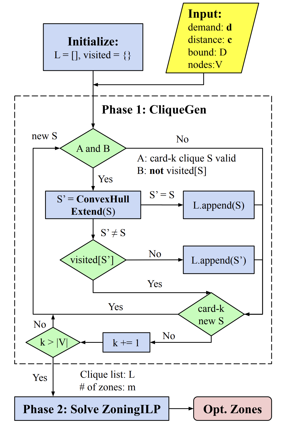
In Phase 1, we design a candidate zone generation algorithm, called CliqueGen, to efficiently enumerate all valid zones with diameters less than , with the full procedure described in Section IV-A. Inspired by the definition of shareability graph [b4], the algorithm iteratively constructs cliques111Following prior work on shareability graphs, we adopt the term clique for our subgraph structure of interest, though our definition differs from the classical graph-theoretic one that a clique is a complete subgraph. – special subgraph structures – of cardinality by progressively extending cliques of cardinality . A clique can be regarded as a valid zone and is defined below.
Definition 1 (-bounded Clique)
Given a graph , a -bounded clique is a subset of nodes , such that the longest shortest-path distance between any two nodes , called the diameter, is less than . The cardinality of a clique is the number of nodes in it, namely .
Although the number of valid zones grows exponentially when the diameter constraint is relaxed, CliqueGen leverages a pruning sub-routine called CovexHullExtend to exclude a large number of zones that do not make physical sense and are dominated by other zones that we keep. Any such dominated zone does not cover all nodes within its convex hull, and thus cannot contribute to an optimal solution to our problem. This significantly reduces the computational overhead and enables practical tractability, as demonstrated in Section LABEL:sec:res. The number of candidate zones generated by CliqueGen for different parameters is detailed in Table LABEL:tab:scalability.
In Phase 2, we formulate an Integer Linear Program (ILP), denoted by ZoningILP, to select the optimal zones given the full list of cliques generated in Phase 1. Such an optimization problem is a variant of the classical Weighted Maximum Coverage Problem (WMCP) [b14]. The full formulation and discussions are in Section IV-B.
IV-A Candidate Zone Generation
Given a diameter bound , CliqueGen builds up the list of cliques in an iterative manner. It begins by initializing a list with all cardinality- cliques (i.e., single nodes). Then, at any arbitrary iteration , CliqueGen attempts to construct all possible cliques of cardinality that can be directly extended from at least one cardinality-(-1) clique. Specifically, if a clique such as is deemed invalid at iteration , any superset, like with being any other nodes, will be excluded by the algorithm for further consideration. A new cardinality- clique formed by adding node to an existing clique is retained in list only if for all . This condition ensures that lies within the diameter constraint relative to all members of , effectively enforcing a local geographic proximity requirement.
This idea is analogous to the the notion of shareability in prior works [b4] [b12] [b13], where trip-level shareability is verified based on the temporal or spatial proximity between origin-destination pairs. However, our setting is even simpler in two key ways: (1) CliqueGen assesses the shareability at the node level rather than the trip level, and (2) pairwise node-level shareability suffices to guarantee clique-level validity. The latter is in contrast to trip-based models, where verifying group shareability typically requires solving an NP-hard Pick-up and Delivery Problem (PDP) for all origins and destinations, whereas our clique validation takes only at most distance checks.
At an iteration , once CliqueGen identifies a new clique from an existing clique , it invokes a sub-routine called ConvexHullExtend to check whether the new clique can be further extended by adding nodes within its convex hull, , geographically. If ConvexHullExtend can find a set of additional nodes contained in , the convex-hull-extended clique is added to the list , and clique is discarded. Otherwise, clique is added to . Once all cardinality- clique extensions are processed, CliqueGen moves to iteration . The algorithm terminates when cannot increase anymore, which occurs when cliques are over-extended (i.e., new nodes are far away) and the diameter constraint is near violation. The pseudo-code for CliqueGen is provided in Algorithm 1.
The rationale behind the convex hull extension is that a “hollow” clique, one that omits nodes contained within its convex hull, will always be dominated by the zone that includes the omitted nodes, as illustrated in Figure 2. This is because it has the same diameter as the “hollow” clique (i.e., it is also feasible), but potentially serves more travel demand. Therefore, CliqueGen will only include convex cliques, formalized in Definition 2, into the list .
Definition 2 (Convex Clique)
A clique is convex if it is closed under the convex hull extension in the node set . Equivalently, .
The sub-routine ConvexHullExtend is executed as follows: given a clique and the node set , it iteratively examines each node and determines if is shareable with all nodes in , using the same pairwise shareability check as in CliqueGen. Since the internal shareability of is already validated, each new candidate node only requires checks to complete the validation. If is shareable with the entire , an oracle is further invoked to check whether is contained in before integrating into . The original clique keeps expanding along the loop until no more new node is found within . Given that the “point-in-convex-hull” oracle takes steps, the overall time complexity of ConvexHullExtend is . The pseudo-code is provided in Algorithm 2.
It is important to note that a naive implementation of CliqueGen can be highly inefficient due to extensive re-computation in the following aspect: the algorithm may repeatedly examine the same set of nodes as it checks the formation of an identical valid clique from different lower-cardinality cliques. To address this issue, we design a data structure called visited that maps the sorted tuple of cliques to a binary flag indicating whether the combination has been explored in previous steps. CliqueGen always checks visited before extending an existing clique with a new node , or with a new set of nodes contained in . If visited returns true for a combination, the step is skipped to save computation. Similarly, whenever CliqueGen inserts a newly found clique into the list , it updates the map with visited[sorted()] = 1.
IV-B Optimal Zoning via Maximum Coverage
Given the comprehensive list of all the candidate valid zones generated by CliqueGen, the goal in Phase 2 is to select zones from that maximizes the total demand served, as described in Equation 1. Since the demand table is defined over node pairs, allowing zones to overlap can lead to higher total coverage and thus better solutions. This problem reduces to a Weighted Maximum Coverage Problem with sets.
Let be a binary decision variable indicating whether a candidate valid zone is selected. Let be a binary decision variable indicating whether both nodes are jointly covered by at least one selected zones. For each zone , define a binary vector capturing the mapping between zone and all the nodes in . In particular, if node , and otherwise. These vectors are provided as input as they can be directly derived from the clique list generated in Phase 1. With the notations properly defined, we formulate ZoningILP, consisting of the objective function and constraints from (2a) to (2e), to solve this maximum coverage problem exactly.
| (2a) | |||
| (2b) | |||
| (2c) | |||
| (2d) | |||
| (2e) | |||