Data Augmentation and Resolution Enhancement using GANs and Diffusion Models for Tree Segmentation
Abstract
Urban forests play a key role in enhancing environmental quality and supporting biodiversity in cities. Mapping and monitoring these green spaces are crucial for urban planning and conservation, yet accurately detecting trees is challenging due to complex landscapes and the variability in image resolution caused by different satellite sensors or UAV flight altitudes. While deep learning architectures have shown promise in addressing these challenges, their effectiveness remains strongly dependent on the availability of large and manually labeled datasets, which are often expensive and difficult to obtain in sufficient quantity. In this work, we propose a novel pipeline that integrates domain adaptation with GANs and Diffusion models to enhance the quality of low-resolution aerial images. Our proposed pipeline enhances low-resolution imagery while preserving semantic content, enabling effective tree segmentation without requiring large volumes of manually annotated data. Leveraging models such as pix2pix, Real-ESRGAN, Latent Diffusion, and Stable Diffusion, we generate realistic and structurally consistent synthetic samples that expand the training dataset and unify scale across domains. This approach not only improves the robustness of segmentation models across different acquisition conditions but also provides a scalable and replicable solution for remote sensing scenarios with scarce annotation resources. Experimental results demonstrated an improvement of over 50% in IoU for low-resolution images, highlighting the effectiveness of our method compared to traditional pipelines.
Keywords tree segmentation generative adversarial networks diffusion models
1 Introduction
Urban forests are increasingly recognized for their significant benefits to human well-being. They contribute to energy savings, reduce stormwater runoff, and improve water quality [17, 18]. Additionally, these forests provide essential ecosystem services that combat climate change, such as carbon sequestration, oxygen generation, water cycling, soil conservation, and mitigation of the urban heat island effect. Automated tree mapping is essential for effective management of both native and invasive vegetation [12, 2].
For monitoring urban forest resources, satellite remote sensing has been crucial. However, the heterogeneous structure and surface complexity of urban environments, combined with the limited spatial resolution of satellite imagery, pose significant challenges for the accurate detection and delineation of individual trees [17, 12]. In recent years, high-resolution aerial RGB imagery, which is easy to use and available at low cost, has become widely accessible. Unlike satellite images, UAV-acquired imagery typically includes only three RGB channels, which, while providing limited spectral information, enables clear visualization and extraction of structural characteristics such as shape, size, and texture of ground objects [7].
In this context, techniques such as semantic segmentation, which offer pixel-based classification, are increasingly employed across a range of applications. Recent advancements in tree detection, classification, and segmentation predominantly utilize deep learning networks, such as ConvNets [7, 8, 10], applied to aerial RGB and multispectral imagery [2, 17, 18]. More recently, transformers have also been utilized for tree counting in aerial images [3].
Accurately detecting individual tree from remote sensing data presents a significant challenge for traditional deep learning-based methods due to the variability encountered in cross-regional scenarios [20, 11, 22]. This variability can arise from various factors, including deformations or shifts caused by biased sampling in the spatial domain, changes in acquisition conditions (such as variations in illumination or acquisition angle), or seasonal changes [15].
Despite substantial advancements with deep neural networks, their performance improvement largely depends on the availability of extensive labeled training data, which involves costly and labor-intensive data curation [5, 1]. The challenge is further compounded when a deep neural network must handle multiple distinct domains. For instance, in tree detecting, each domain might include different scenes (e.g., urban, countryside, farmland), imagery types (e.g., aerial or satellite), and varying levels of tree density, shadows, or overlap among individual trees.
To overcome these challenges, recent works have focused on applying unsupervised domain adaptation in satellite and aerial images. Zheng et al. [22] proposed a domain-adaptive method to detect and count cross-regional oil palm trees using an adversarial learning-based multi-level attention mechanism. Wang et al. [20] also employed an adversarial domain-adaptive model with a transferable attention mechanism for tree crown detection using high-resolution remote sensing images. More recently, AdaTreeFormer was introduced by Amirkolaee et al. [1], demonstrating the ongoing trend of combining adversarial learning with attention mechanisms to perform domain adaptation for tree detection in high-resolution images.
To address these limitations, this study introduces an innovative approach that diverges from prior methodologies. Rather than relying solely on adversarial learning and attention mechanisms applied to high-resolution imagery - as commonly seen in recent work - we propose a domain adaptation strategy using image-to-image translation and super-resolution techniques. Our method leverages models such as pix2pix [9], Real-ESRGAN [19], and both Latent and Stable Diffusion [13] to enhance low-resolution aerial images while preserving their semantic integrity. This enables our effective tree segmentation, using SegFormer [21], without the need for extensive manually labeled datasets, offering a cost-efficient and scalable alternative.
By unifying image scales across domains and automatically generating realistic and annotated synthetic samples, our approach significantly improves model robustness to variations in acquisition conditions, such as flight altitude, tree density, or sensor quality. It provides a versatile and replicable solution for remote sensing scenarios where annotation resources are scarce. Experimental results demonstrate the effectiveness of our pipeline, with IoU improvements exceeding 50% for low-resolution imagery, clearly outperforming traditional supervised training pipelines.
2 Methodology
2.1 Dataset
The images used in the experiments are separated into the datasets and based on the ground sample distance (GSD) utilized in the capture of the images. The dataset consists of images sized pixels with a 20-centimeter GSD, i.e., each pixel corresponds to approximately 20 cm in the real world. The dataset consists of images sized pixels with a 50-centimeter GSD. Thus, the resolution of the images in the dataset is 2.5 times greater than that of the images in the dataset.
| Dataset | GSD | Train | Validation | Test | Total |
| P20 | 20cm | 218 | 36 | 109 | 363 |
| P50 | 50cm | 134 | 23 | 67 | 224 |
The images consist of aerial views of urban environments and have been manually annotated by specialists as either background or tree classes. Sample images from both datasets, along with their respective annotations, can be seen in Figure 1, and the distribution of images in these datasets is shown in Table 1.
2.2 Proposed Approach
Differences in ground sample distance (GSD) across datasets affect the pixel representation of image elements such as trees and roads, as shown in Figure 1. While the size of these elements may remain consistent within a single dataset, variations in GSD between datasets introduce inconsistencies that can hinder model generalization and transferability. To address this, we propose an approach that harmonizes the scale of visual features by adjusting the GSDs through upsampling techniques, ensuring a more uniform representation of key elements across datasets.
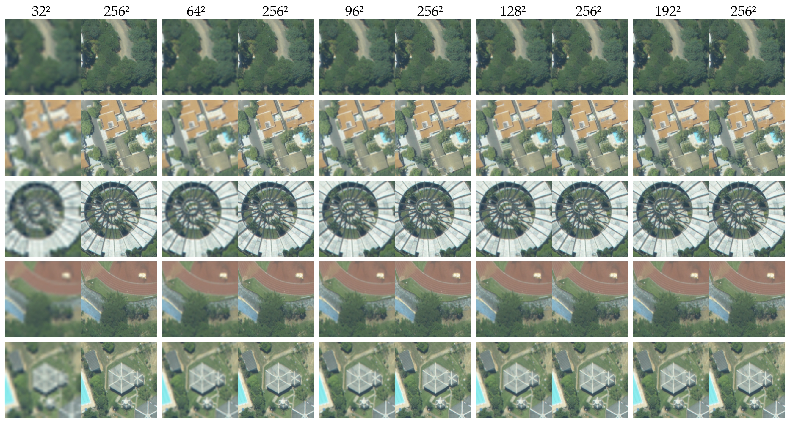
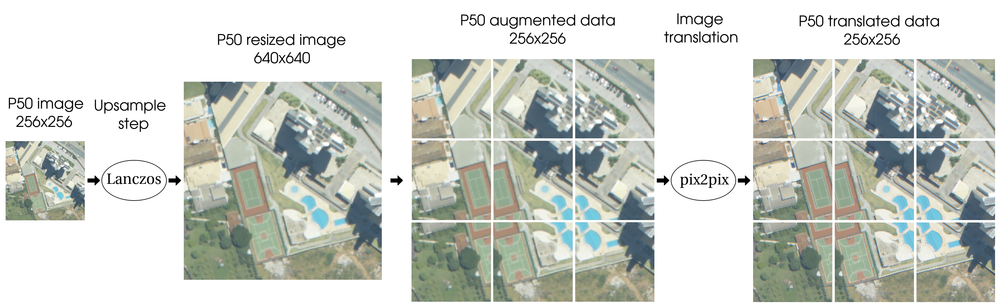
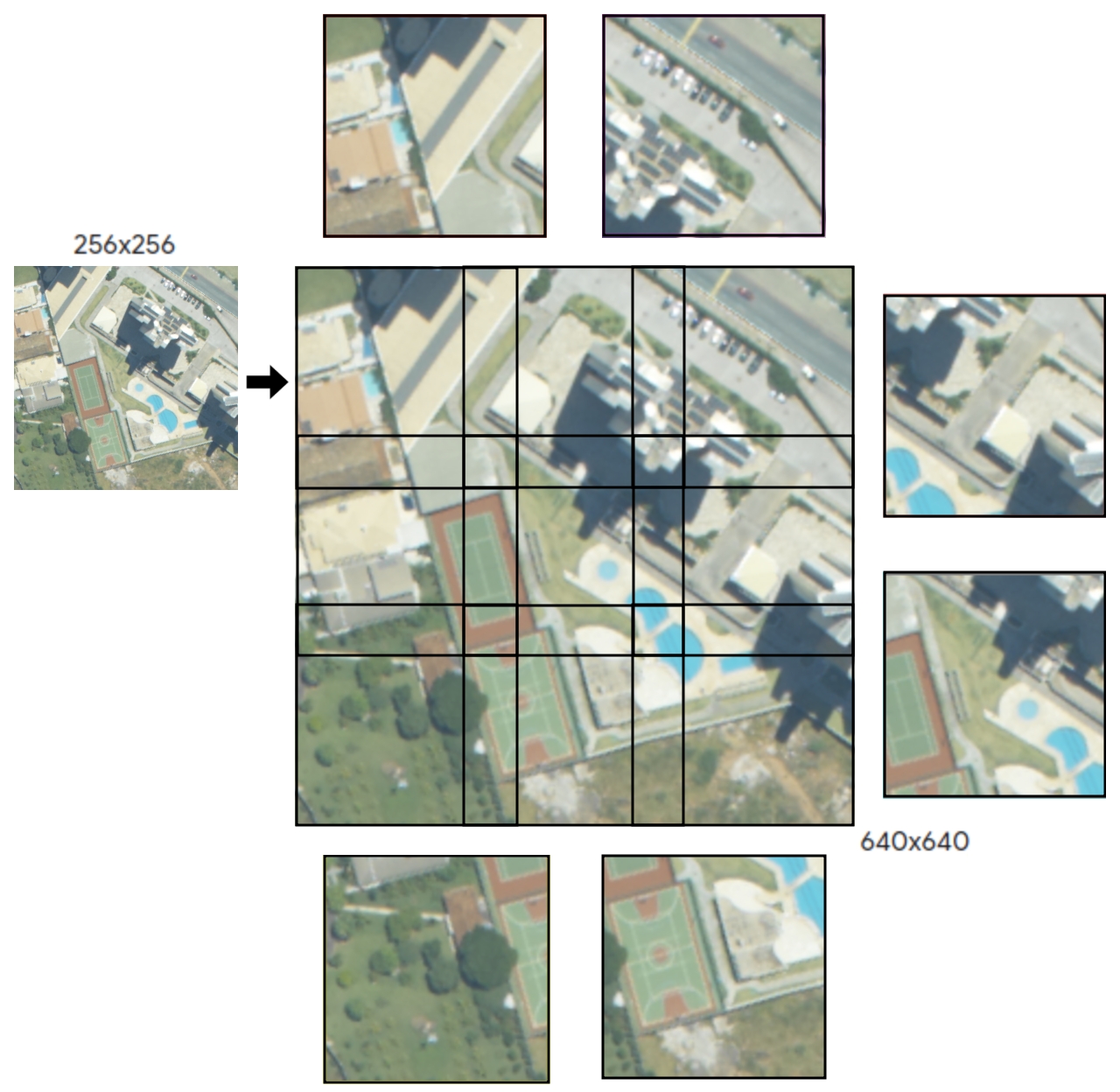
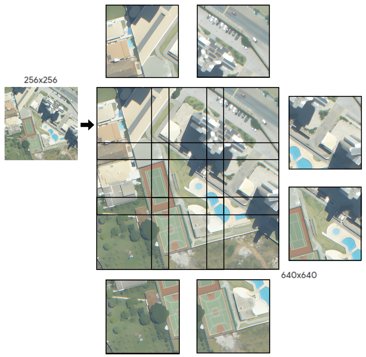
We developed two different methods to implement this strategy. In our first method, we upsample the dataset, which has a difference in centimeters per pixel compared to the dataset, by resizing the images from to using the default ImageMagick filter, Lanczos resampling [6, 14], to make the size of objects similar to those in the dataset. After this step, we generated 9 patches of size .
This process also augments the data in the dataset by a factor of 9, increasing it from images to images. However, this procedure significantly decreases the resolution of these images, which could hamper the performance of network training and increase the data shift compared to the other dataset. To overcome this drawback, we trained pix2pix models to perform image-to-image translation and address the loss of resolution. The pipeline of this method can be seen in Figure 2. A more detailed visualization of the process for generating patches is illustrated in Figure 3.
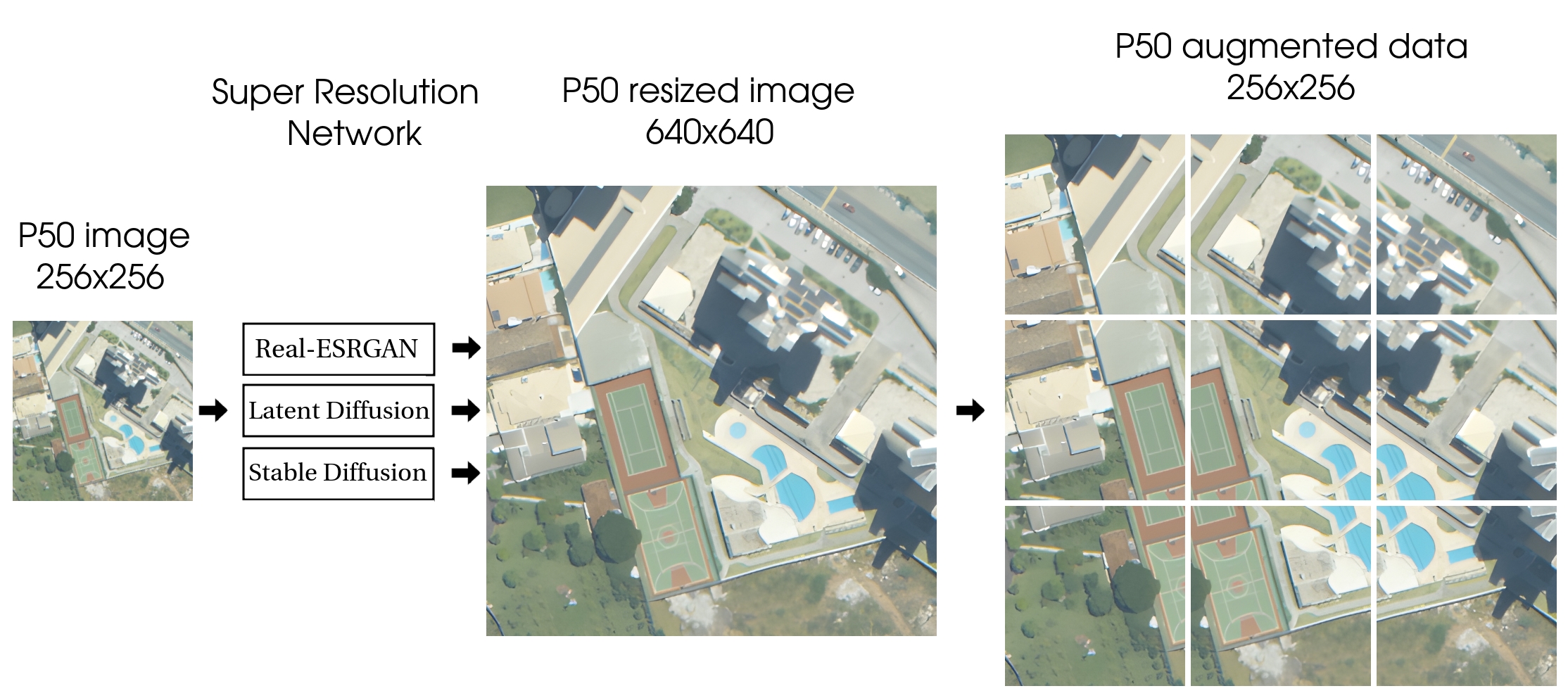
In our second approach, we used recent super-resolution GANs and Diffusion models to upsample the images directly without loss of quality. The pipeline for this method is illustrated in Figure 4. The advantage of this approach is that we can leverage publicly available models trained on millions of images, unlike the pix2pix model, which needed to be trained from scratch with image pairs generated from our training sets. However, these models do not achieve direct image-to-image translation between the two domains; they primarily enhance resolution to compensate for quality loss during upsampling.
Additionally, it is important to highlight that both approaches used here produce nine times more data from the original images, with these new images having a 2.5 times superior ground sample distance. Since we also updated all annotations for the new GSD automatically, this process helps address the cost of pixel-annotated data and mitigates the drawbacks of low-resolution aerial images. It produces significantly more high-quality annotated data, which is required to train deep learning models efficiently, in a fully automatic way. In the following sections, we provide more details about the methods used.
2.2.1 Paired Image-to-Image Translation: pix2pix
Pix2pix is an image-to-image translation GAN and has shown promising results in datasets with a paired image relationship between the source and target domains, such as the Facade and Cityscapes datasets [16, 4]. The image-to-image translation used here could alleviate distortions in the generated images that might otherwise decrease the segmentation performance in subsequent steps. However, since we lack a direct relationship between the images of the two datasets, and , to perform a true paired translation, we proposed two approximate mapping approaches.
| Dataset | Generation Method | GSD | Train | Validation | Test | Total | ||
| P50-20p |
|
20cm | 1206 | 207 | 603 | 2016 | ||
| P50-50p |
|
20cm | 1206 | 207 | 603 | 2016 |
To perform the mapping required for paired image-to-image translation used in pix2pix, we reduced the resolution of the images in datasets and . For dataset , we used resolutions of , , , , and . For dataset , we used resolutions of , , , , and . After resizing to these smaller resolutions, we upscaled the images back to without any preprocessing steps and generated paired images. Examples of these paired images can be found in Supplementary Material. We trained two different pix2pix models using these pairs.
We used the images obtained after applying the Lanczos method to the dataset, as illustrated in Figure 3, as input for the pix2pix models, generating two new datasets: and . The distribution of images in these datasets is described in Table 2. Sample images from these datasets are shown in Figure 5.
2.2.2 Super-Resolution Models: Real-ESRGAN, Latent and Stable Diffusion
| Dataset | Generation Method | GSD | Train | Validation | Test | Total |
| P20G | Real-ESRGAN | 20cm | 218 | 36 | 109 | 363 |
| P50G | Real-ESRGAN | 20cm | 1206 | 207 | 603 | 2016 |
| P20D | Latent Diffusion | 20cm | 218 | 36 | 109 | 363 |
| P50D | Latent Diffusion | 20cm | 1206 | 207 | 603 | 2016 |
| P20S | Stable Diffusion | 20cm | 218 | 36 | 109 | 363 |
| P50S | Stable Diffusion | 20cm | 1206 | 207 | 603 | 2016 |
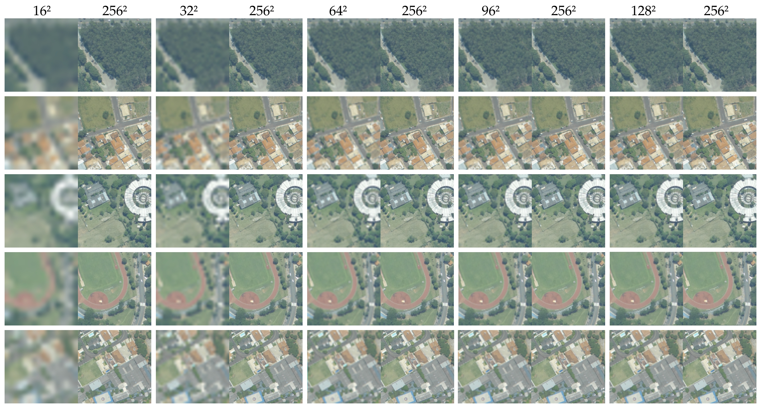
We used the Real-ESRGAN and Diffusion public models, without any fine-tuning, to generate our images from dataset . Using the resulting super-resolution images, we generated 9 patches of size , as described in Figure 6. For dataset , we upscaled the original images to using the models and then resized them back to the original size of to maintain similarity with the images generated by the previous pipeline. The distribution of images in each generated dataset can be seen in Table 3, where the suffix G represents Real-ESRGAN, the suffix D represents Latent Diffusion, and the suffix S represents Stable Diffusion.
Using Stable Diffusion, we have the option to provide a prompt that guides the image generation. While this could be an advantage over Latent Diffusion, for this work, this feature poses a challenge in choosing a prompt that optimizes our segmentation results. Since evaluating the optimal prompt for the segmentation task is somewhat beyond the scope of this work, we used the prompt Enhance the resolution of this aerial city image without applying any filter, which was selected from a few alternatives based on its superior qualitative visual results.
2.3 Evaluation Metrics
To assess and compare the networks evaluated in the experiments, we used the metric commonly applied in the literature: intersection over union (IoU) at the pixel level, described in Equation 1.
| (1) |
where P corresponds to model prediction and GT corresponds to Ground Truth.
In all experimental results presented here, the notation indicates that the model was trained on images from dataset and evaluated on test images from dataset . Thus, signifies that training and test images come from the same dataset, while denotes a scenario where the model is trained on one dataset and evaluated on a different dataset.
2.4 Experimental Setup
We ran our experiments with SegFormer, pix2pix, and Real-ESRGAN using the free version of Google Colab with a T4 GPU. For experiments with Latent Diffusion, and Stable Diffusion, we utilized an Intel(R) Core (TM) i7-5820K CPU @ 3.30GHz with 32 GB of RAM, and an Nvidia GeForce GTX TITAN X GPU with 12 GB GDDR5 memory and 3072 CUDA Cores.
In our supervised segmentation tests with SegFormer, we utilized the available architectures in MMSegmentation, accessible at https://github.com/open-mmlab/mmsegmentation. For training, we used the base configuration files provided by MMSegmentation, specifically using the Cityscapes configuration with the MIT-B5 backbone, a crop size of , and a learning rate schedule set at . Additionally, we adjusted the image scale to , modified the number of classes in the decode/auxiliary head to , and resized the crop size to to better suit our dataset.
For pix2pix training, we utilized the original code provided by the authors, accessible at github.com/junyanz/pytorch-CycleGAN-and-pix2pix. Each model was trained for 200 epochs with decay initiated after 100 epochs. No additional training or fine-tuning was conducted for Real-ESRGAN. Inference was performed using the default configurations provided in the script available from the authors’ repository at github.com/xinntao/Real-ESRGAN.git.
For Latent and Stable Diffusion, we utilized the implementation provided by the authors in python library format, accessible at github.com/CompVis/latent-diffusion and github.com/CompVis/stable-diffusion. The images resulting from inference by the GANs and Diffusion models were used to train the SegFormer model.
Unlike Real-ESRGAN, the outscale parameter of the pre-trained Diffusion models could not be adjusted to a value smaller than 4. Due to our machine’s 12GB memory limitation, we were unable to resize images from to directly. Therefore, we divided our original images into 4 patches of , upscaled them using the Diffusion models, and then used the 4 upscaled patches to reconstruct the image with size . We acknowledge that this step could have impacted our results and consider this aspect a limitation of the Diffusion pre-trained models.
3 Results and Discussion
3.1 Baseline
We evaluated the performance of supervised segmentation using SegFormer on two original datasets, and , without upsampling the original images. The results are presented on the left side of Table 4. While both datasets achieved considerable performance in terms of IoU metric, dataset exhibited a higher IoU than dataset . This outcome was anticipated, given that dataset comprises higher-resolution images and a larger training set.
| P20 P20 | P50 P50 | P50 P20 | P20 P50 | |
| SegFormer (MiT-B5) | ||||
| Background | 94.87 | 95.56 | 91.05 | 94.22 |
| Trees | 77.44 | 70.18 | 57.43 | 63.27 |
| Average | 86.15 | 82.87 | 74.25 | 78.75 |
We also evaluated the models on a different dataset than those used for training (i.e., source model only). The results are presented on the right side of Table 4. When segmenting target images with models trained on images from a different domain, a noticeable decrease in IoU is observed due to data shift. This performance drop is particularly pronounced when using the model trained on dataset to segment images from dataset , where the IoU decreases from 77.44 to 57.43 for the Trees class, approximately a 25.8% drop.
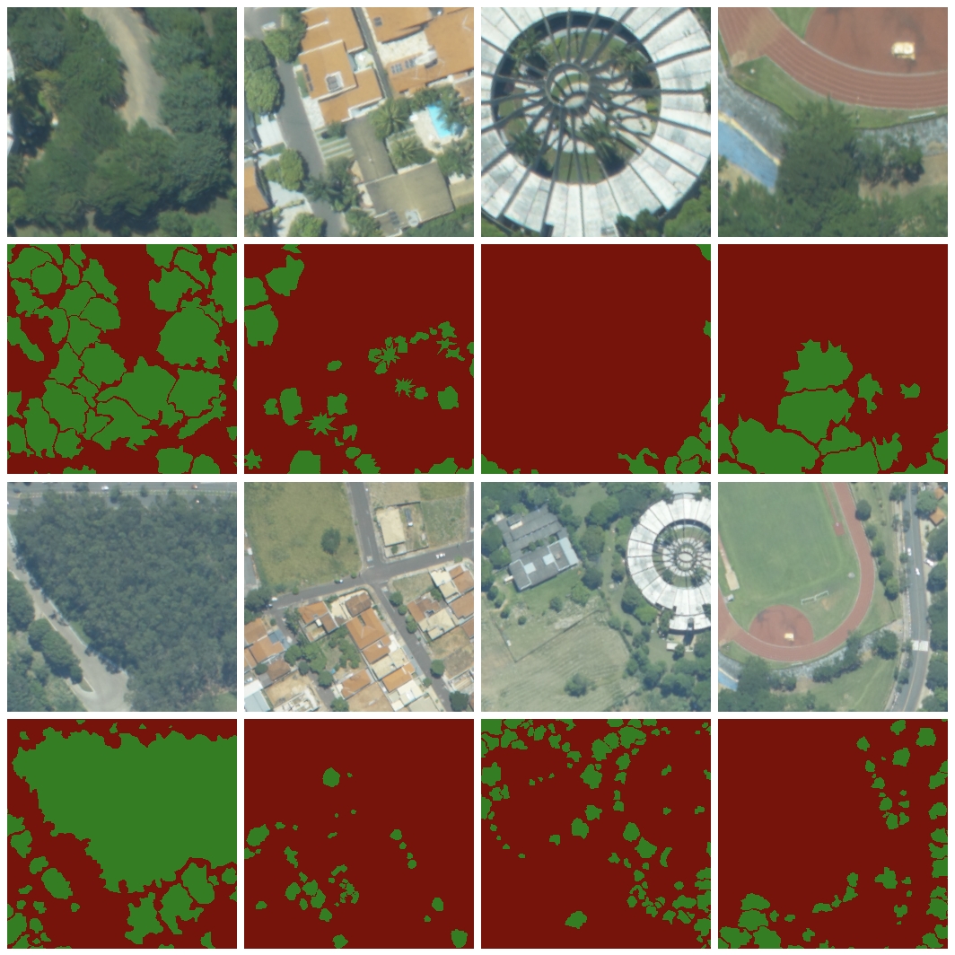
In Figure 7 we can see the visual predictions using the SegFormer model trained with images from datasets and . The models performed well even when segmenting images from a different domain. However, the model failed to detect some large trees and occasionally misidentified grass as trees in the images. The model failed to detect smaller trees in the images, but the reduced size of the trees generated a smaller impact on the average IoU.

Although we can consider the performance of the source model only reasonable in these experiments, given the similarity of the images in both datasets, the next sections analyze techniques aimed at improving these results, as well as enhancing the performance of supervised segmentation.
3.2 Paired Image-to-Image Translation
3.2.1 pix2pix
| P50-20pP50-20p | P50-50pP50-50p | P50P50 | |
| SegFormer (MiT-B5) | |||
| Background | 96.05 | 95.99 | 95.56 |
| Trees | 73.25 | 72.77 | 70.18 |
| Average | 84.65 | 84.37 | 82.87 |
We trained two pix2pix models using the pairs described in Section 2.2.1. These models were used to generate two new datasets, and , which consist of translated images from dataset after applying the upsampling process. The results of the SegFormer supervised segmentation trained with these models can be seen in Table 5. In both cases, we observe an improvement in IoU compared to supervised segmentation using the original images.

| P20P50-20p | P20P50-50p | P20P50 | P50-20pP20 | P50-50pP20 | P50P20 | |
| SegFormer (MiT-B5) | ||||||
| Background | 94.65 | 94.48 | 94.22 | 93.07 | 92.94 | 91.05 |
| Trees | 67.20 | 66.29 | 63.27 | 68.05 | 67.43 | 57.43 |
| Average | 80.92 | 80.38 | 78.75 | 80.56 | 80.19 | 74.25 |
However, it is important to highlight that we are not evaluating the translated images from dataset directly but rather the corresponding augmented data generated through the upsampling process; thus, this improvement could also be attributed to the data augmentation process.
Nevertheless, it is an interesting finding that, in these experiments, we were able to enhance our segmentation results using the same network, SegFormer, without the need for more labeled images for training. Instead, we achieved this increase by generating more images at the same size but with lower resolution and then improving the quality using paired image-to-image translation, showing the potential of our data augmentation method.
We also evaluated these models as source model only on the test images from dataset and evaluated the model trained with images from dataset on the images generated by pix2pix. The results can be seen at Table 6. In all tests, we achieved significant improvements compared to the results on the original images of dataset without using image-to-image translation. The best model trained with pix2pix images improved the IoU for the Trees class from 57.43 to 68.05, reducing the gap with the supervised results of , 77.43, by approximately 60%.
3.3 Super-Resolution Models
We used the super-resolution models to generate high-resolution images from the datasets and , as described in Section 2.2.2. We evaluated the SegFormer model trained on these images and compared its performance to training using the original images. The results for each network evaluated are detailed in the following sections.
3.3.1 Real-ESRGAN
| P20G P50G | P20 P50 | P50G P20G | P50 P20 | |
| SegFormer (MiT-B5) | ||||
| Background | 94.86 | 94.22 | 92.45 | 91.05 |
| Trees | 66.57 | 63.27 | 63.92 | 57.43 |
| Average | 80.71 | 78.75 | 78.19 | 74.25 |
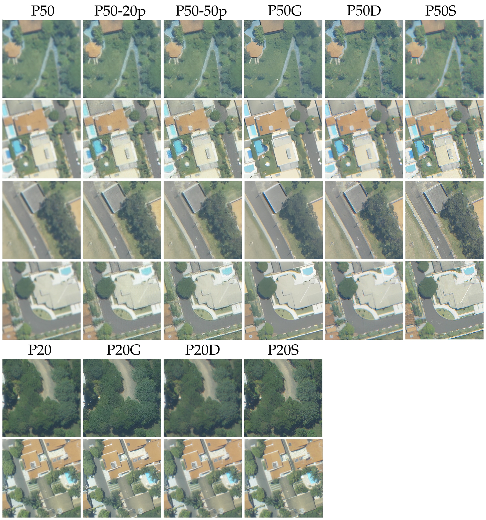
Although the images generated by Real-ESRGAN exhibit superior visual quality compared to those generated by pix2pix models, as depicted in Figure 5, the results of our experiments were slightly inferior to those achieved by SegFormer trained with images translated by pix2pix models, as shown in Table 7. This difference can be attributed to the fact that while we trained the pix2pix models using images from our specific datasets, Real-ESRGAN uses a super-resolution model trained on general images.
This lack of training could have led the network to distort the semantic information of some pixels, resulting in a decrease in the segmentation results. However, it is worth highlighting that omitting the training step sped up our pipeline. Moreover, while semantic distortion of pixels can significantly impact segmentation tasks, in other tasks such as object detection, this effect is generally negligible.
3.3.2 Latent and Stable Diffusion
| P20DP50D | P20SP50S | P20P50 | P50DP20D | P50SP20S | P50P20 | |
| SegFormer (MiT-B5) | ||||||
| Background | 94.42 | 94.63 | 94.22 | 92.59 | 91.63 | 91.05 |
| Trees | 65.58 | 65.59 | 63.27 | 65.36 | 62.73 | 57.43 |
| Average | 80.00 | 80.11 | 78.75 | 78.97 | 77.18 | 74.25 |

With our Diffusion models, we obtained results similar to Real-ESRGAN, as shown in Table 8. We also experimented a combination of models trained using Latent and Stable Diffusion. One interesting finding was that our best results were achieved using a model trained with images from dataset to segment the test images from dataset , achieving an IoU of 67.79 for the Trees class, superior to our results shown in the Table.
However, it’s difficult to establish a specific reason for this behavior, mainly due to the fact that the resulting images from Stable Diffusion are strongly influenced by the prompt used. Nevertheless, this aspect may highlight the possibilities that can be explored with the use of Stable Diffusion in similar tasks. In Figure 9, we can observe a visual comparison of the segmentation results of datasets generated by the super-resolution methods.
3.4 Low Resolution Images
Despite a 2.5-fold resolution difference between our original datasets and , the visual quality in both cases was good, and the slight disparity in resolution between the datasets allowed us to achieve satisfactory results with the source model only approach, even without applying image translation or using super-resolution networks. One scenario not addressed in our experiments with these datasets is using our trained models with images of lower quality than those used in training.
| P20 P20lr | P20 P20lp | P20 P20lG | P20 P20lD | P20 P20 | |
| SegFormer (MiT-B5) | |||||
| Background | 89.72 | 92.43 | 90.22 | 90.41 | 94.87 |
| Trees | 50.99 | 67.80 | 61.71 | 61.60 | 77.44 |
| Average | 70.36 | 80.11 | 75.97 | 76.00 | 86.15 |
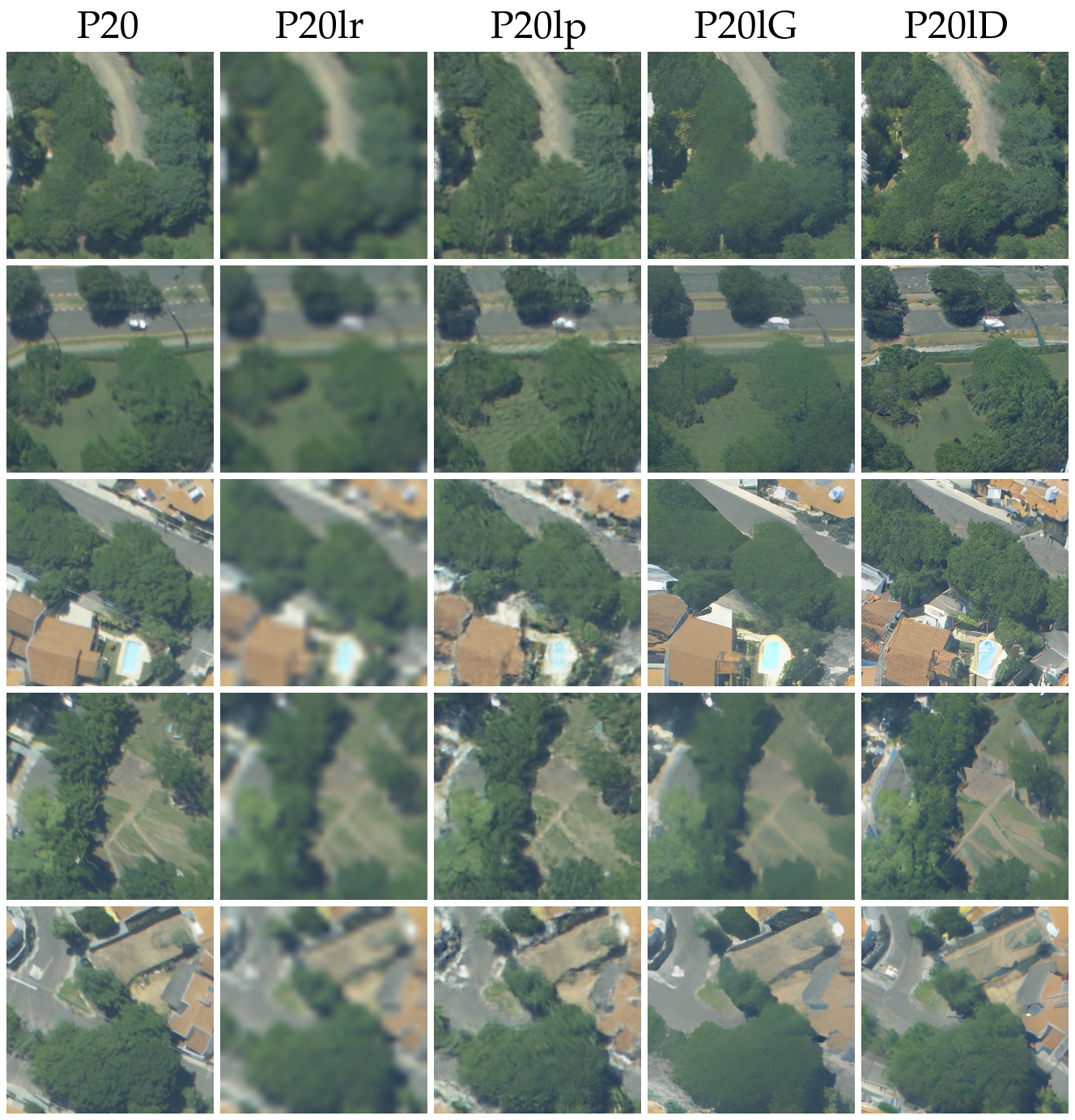
We decided to simulate this scenario to evaluate the performance of the techniques presented here in enhancing the quality of low-resolution images. To simulate it, we resized the original images from the dataset to , decreasing their resolution by 8 times. This represents a difference significantly greater than the 2.5 times difference in our datasets.

Through this process, we created the dataset lr (P20 low resolution) and used it to test our GANs and Diffusion methods, creating new datasets with translated images. We generated the dataset lp after applying pix2pix translation in lr, the dataset lG after increasing the resolution using Real-ESRGAN, and the dataset lD after enhancing the resolution with Latent Diffusion. Examples of images from these datasets can be found in Supplementary Material.
In Table 9, we present the IoU results of segmentation using our model trained with images from dataset . There is a noticeable decrease in performance when our model trained with original images segments low-resolution images from database lr. However, when segmenting target images translated by the pix2pix model, this same model achieved significantly better results compared to those obtained using super-resolution models, despite the visually superior quality of images generated by Latent Diffusion, particularly evident in the depiction of roofs.
This evaluation corroborates the idea that, for the approach used in this work, preserving the semantic information of original pixels is more crucial for segmentation results than achieving high visual quality in the generated images. However, it is important to acknowledge the capability of super-resolution models to generate coherent images from low-resolution inputs using a publicly available checkpoint without fine-tuning and the training process required by pix2pix models. The visual predictions, compared to the ground truth, can be seen in Figure 10.
4 Conclusion
In this work, we introduced an approach to enhance the resolution of aerial images to improve tree detection performance by utilizing image-to-image translation and super-resolution methods. Our method introduced a novel data augmentation technique, employing upsampling to generate high-quality annotated samples with varying ground sample distances (GSD). This approach also addresses the costly and labor-intensive process of manually labeling data.
Our data augmentation pipeline, which combines upsampling with translation and super-resolution steps, can be applied with different scaling factors to create new labeled images across a range of GSDs. This process enables the network to adapt to different image capture heights, thereby increasing the robustness of the supervised model when applied to new domains. Our evaluation revealed that lightweight models, such as pix2pix, can compete effectively with more recent and complex networks in translating images when trained appropriately.
In addition, we also conducted experiments reducing the resolution of our original dataset images, which were generally of high quality, by a factor of eight and evaluated the model’s performance on both the original and enhanced images. The results demonstrated that our upsampling pipeline using pix2pix improved IoU tree detection performance by more than 50% when compared to the low-resolution images, validating the effectiveness of our upsampling strategy. The methods for enhancing resolution presented in this work can be applied in scenarios where remote sensing images lack the necessary quality for achieving high accuracy in computer vision tasks, such as detection, classification, and segmentation.
References
- Amirkolaee et al. [2024] Hamed Amini Amirkolaee, Miaojing Shi, Lianghua He, and Mark Mulligan. Adatreeformer: Few shot domain adaptation for tree counting from a single high-resolution image. arXiv preprint arXiv:2402.02956, 2024.
- Beloiu et al. [2023] Mirela Beloiu, Lucca Heinzmann, Nataliia Rehush, Arthur Gessler, and Verena C Griess. Individual tree-crown detection and species identification in heterogeneous forests using aerial rgb imagery and deep learning. Remote Sensing, 15(5):1463, 2023.
- Chen and Shang [2022] Guang Chen and Yi Shang. Transformer for tree counting in aerial images. Remote Sensing, 14(3):476, 2022.
- Cordts et al. [2016] Marius Cordts, Mohamed Omran, Sebastian Ramos, Timo Rehfeld, Markus Enzweiler, Rodrigo Benenson, Uwe Franke, Stefan Roth, and Bernt Schiele. The cityscapes dataset for semantic urban scene understanding. In Proceedings of the IEEE conference on computer vision and pattern recognition, pages 3213–3223, 2016.
- dos Santos Ferreira et al. [2019] Alessandro dos Santos Ferreira, Daniel Matte Freitas, Gercina Gonçalves da Silva, Hemerson Pistori, and Marcelo Theophilo Folhes. Unsupervised deep learning and semi-automatic data labeling in weed discrimination. Computers and Electronics in Agriculture, 165:104963, 2019.
- Duchon [1979] Claude E Duchon. Lanczos filtering in one and two dimensions. Journal of Applied Meteorology and Climatology, 18(8):1016–1022, 1979.
- Ferreira et al. [2020] Matheus Pinheiro Ferreira, Danilo Roberti Alves de Almeida, Daniel de Almeida Papa, Juliano Baldez Silva Minervino, Hudson Franklin Pessoa Veras, Arthur Formighieri, Caio Alexandre Nascimento Santos, Marcio Aurélio Dantas Ferreira, Evandro Orfano Figueiredo, and Evandro José Linhares Ferreira. Individual tree detection and species classification of amazonian palms using uav images and deep learning. Forest Ecology and Management, 475:118397, 2020.
- Iqbal et al. [2021] Muhammad Shakaib Iqbal, Hazrat Ali, Son N Tran, and Talha Iqbal. Coconut trees detection and segmentation in aerial imagery using mask region-based convolution neural network. IET Computer Vision, 15(6):428–439, 2021.
- Isola et al. [2017] Phillip Isola, Jun-Yan Zhu, Tinghui Zhou, and Alexei A Efros. Image-to-image translation with conditional adversarial networks. In Proceedings of the IEEE conference on computer vision and pattern recognition, pages 1125–1134, 2017.
- Jintasuttisak et al. [2022] Thani Jintasuttisak, Eran Edirisinghe, and Ali Elbattay. Deep neural network based date palm tree detection in drone imagery. Computers and Electronics in Agriculture, 192:106560, 2022.
- Kapil et al. [2024] Rudraksh Kapil, Seyed Mojtaba Marvasti-Zadeh, Nadir Erbilgin, and Nilanjan Ray. Shadowsense: Unsupervised domain adaptation and feature fusion for shadow-agnostic tree crown detection from rgb-thermal drone imagery. In Proceedings of the IEEE/CVF Winter Conference on Applications of Computer Vision, pages 8266–8276, 2024.
- Lv et al. [2023] Lujin Lv, Xuejian Li, Fangjie Mao, Lv Zhou, Jie Xuan, Yinyin Zhao, Jiacong Yu, Meixuan Song, Lei Huang, and Huaqiang Du. A deep learning network for individual tree segmentation in uav images with a coupled cspnet and attention mechanism. Remote Sensing, 15(18):4420, 2023.
- Rombach et al. [2022] Robin Rombach, Andreas Blattmann, Dominik Lorenz, Patrick Esser, and Björn Ommer. High-resolution image synthesis with latent diffusion models. In Proceedings of the IEEE/CVF conference on computer vision and pattern recognition, pages 10684–10695, 2022.
- Still [2006] Michael Still. The definitive guide to ImageMagick. Apress, 2006.
- Tuia et al. [2021] Devis Tuia, Claudio Persello, and Lorenzo Bruzzone. Recent advances in domain adaptation for the classification of remote sensing data. arXiv preprint arXiv:2104.07778, 2021.
- Tyleček and Šára [2013] Radim Tyleček and Radim Šára. Spatial pattern templates for recognition of objects with regular structure. In Pattern Recognition: 35th German Conference, GCPR 2013, Saarbrücken, Germany, September 3-6, 2013. Proceedings 35, pages 364–374. Springer, 2013.
- Velasquez-Camacho et al. [2023] Luisa Velasquez-Camacho, Maddi Etxegarai, and Sergio de Miguel. Implementing deep learning algorithms for urban tree detection and geolocation with high-resolution aerial, satellite, and ground-level images. Computers, Environment and Urban Systems, 105:102025, 2023.
- Ventura et al. [2024] Jonathan Ventura, Camille Pawlak, Milo Honsberger, Cameron Gonsalves, Julian Rice, Natalie LR Love, Skyler Han, Viet Nguyen, Keilana Sugano, Jacqueline Doremus, et al. Individual tree detection in large-scale urban environments using high-resolution multispectral imagery. International Journal of Applied Earth Observation and Geoinformation, 130:103848, 2024.
- Wang et al. [2018] Xintao Wang, Ke Yu, Shixiang Wu, Jinjin Gu, Yihao Liu, Chao Dong, Yu Qiao, and Chen Change Loy. Esrgan: Enhanced super-resolution generative adversarial networks. In Proceedings of the European conference on computer vision (ECCV) workshops, pages 0–0, 2018.
- Wang et al. [2022] Yisha Wang, Gang Yang, and Hao Lu. Domain adaptive tree crown detection using high-resolution remote sensing images. Journal of Applied Remote Sensing, 16(4):044505–044505, 2022.
- Xie et al. [2021] Enze Xie, Wenhai Wang, Zhiding Yu, Anima Anandkumar, Jose M Alvarez, and Ping Luo. Segformer: Simple and efficient design for semantic segmentation with transformers. Advances in Neural Information Processing Systems, 34, 2021.
- Zheng et al. [2020] Juepeng Zheng, Haohuan Fu, Weijia Li, Wenzhao Wu, Yi Zhao, Runmin Dong, and Le Yu. Cross-regional oil palm tree counting and detection via a multi-level attention domain adaptation network. ISPRS Journal of Photogrammetry and Remote Sensing, 167:154–177, 2020.
Appendix A Supplementary Material