RADLER: Radar Object Detection Leveraging Semantic 3D City Models and Self-Supervised Radar-Image Learning
Abstract
Semantic 3D city models are worldwide easy-accessible, providing accurate, object-oriented, and semantic-rich 3D priors. To date, their potential to mitigate the noise impact on radar object detection remains under-explored. In this paper, we first introduce a unique dataset, RadarCity, comprising 54K synchronized radar-image pairs and semantic 3D city models. Moreover, we propose a novel neural network, RADLER, leveraging the effectiveness of contrastive self-supervised learning (SSL) and semantic 3D city models to enhance radar object detection of pedestrians, cyclists, and cars. Specifically, we first obtain the robust radar features via a SSL network in the radar-image pretext task. We then use a simple yet effective feature fusion strategy to incorporate semantic-depth features from semantic 3D city models. Having prior 3D information as guidance, RADLER obtains more fine-grained details to enhance radar object detection. We extensively evaluate RADLER on the collected RadarCity dataset and demonstrate average improvements of 5.46% in mean average precision (mAP) and 3.51% in mean average recall (mAR) over previous radar object detection methods. We believe this work will foster further research on semantic-guided and map-supported radar object detection. Our project page is publicly available at https://gpp-communication.github.io/RADLER.
1 Introduction
fmcw radar is a widely used type of millimeter-wave (mmWave) radar, having applications in diverse domains, including object detection [35, 28, 27, 18], human activity detection [32, 22], and hand gesture recognition [46, 10]. Unlike image and LiDAR object detection [41, 37], \Acfmcw radar produces data in radio frequency (RF) form. By applying Fast Fourier Transforms (FFTs), range, Doppler velocity, and azimuth can be derived, enabling the generation of radar point clouds through constant false alarm rate (CFAR) detection and clustering. However, radar signals are hardly interpretable by humans, making manual annotation impractical. The lack of labeled radar datasets significantly limits the development of learning-based methods in radar object detection.
Recent contrastive SSL has demonstrated its promise of learning directly from data without annotation in image-related tasks [9, 15, 12]. The inherent spatial or temporal relationship in cross-modal data, such as radar-image pairs, makes them suitable for contrastive SSL approaches. Recent studies [13, 3, 2] have supported its effectiveness in radar object detection. However, frequency modulated continuous wave (FMCW) radars are prone to environmental clutter and multipath propagation, resulting in ghost objects and masking effects that adversely affect accurate detection. While some methods [8, 24, 20] address these issues for radar point clouds, few tackle them in the RF domain.
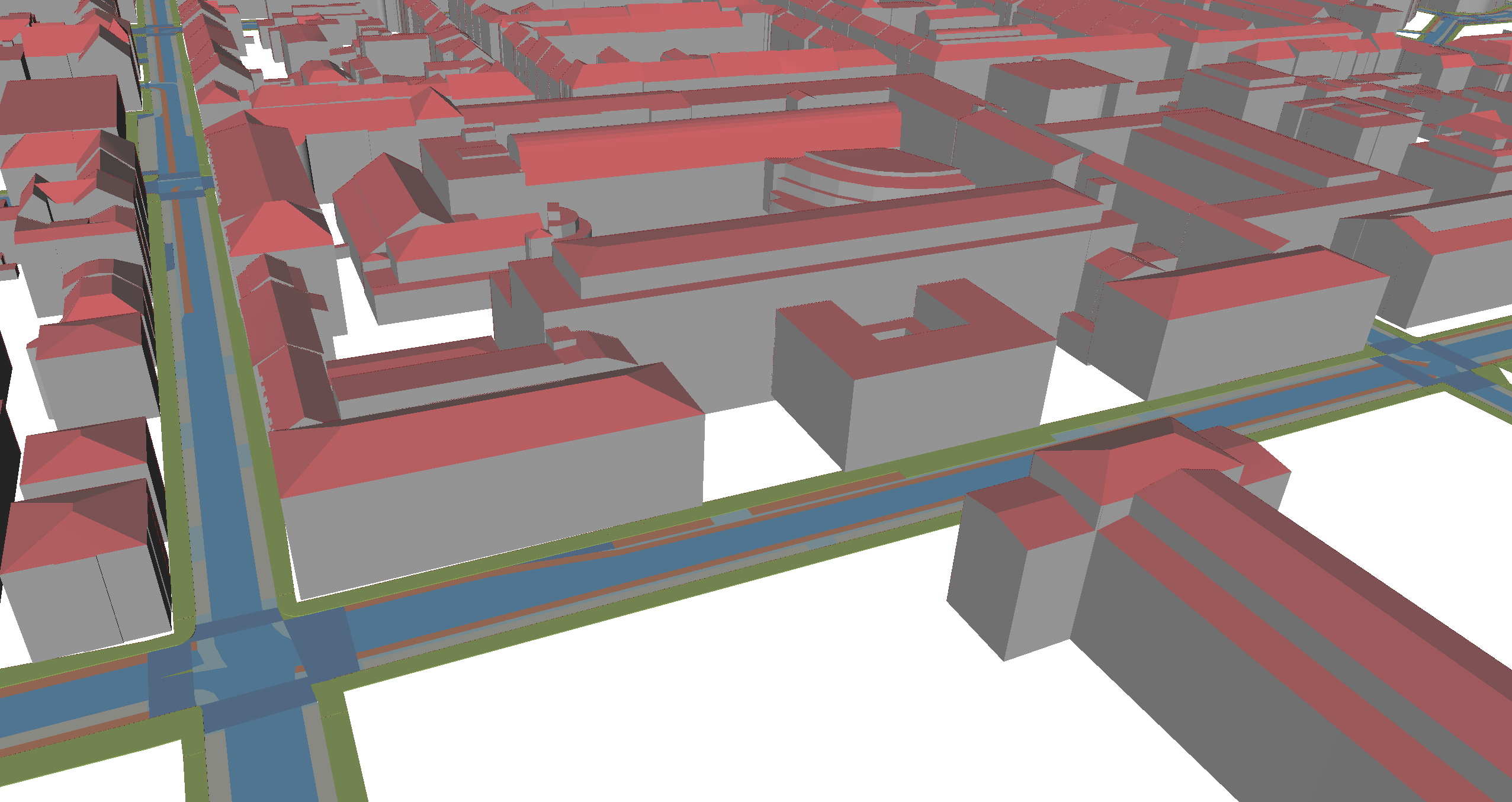
Besides, map-based radar object detection methods are scarce and typically rely only on 3D mesh-like geometries without incorporating semantic information [16]. Actually, semantic 3D city models have become increasingly widespread and easily accessible, e.g., more than 215 million building models worldwide available at no cost [40, 38]. Such city models can provide rich contextual information, such as building functions, road structures, and separated traffic lanes, which can enhance radar perception. Despite their availability, existing radar datasets do not integrate semantic 3D city models, limiting research into their potential benefits.
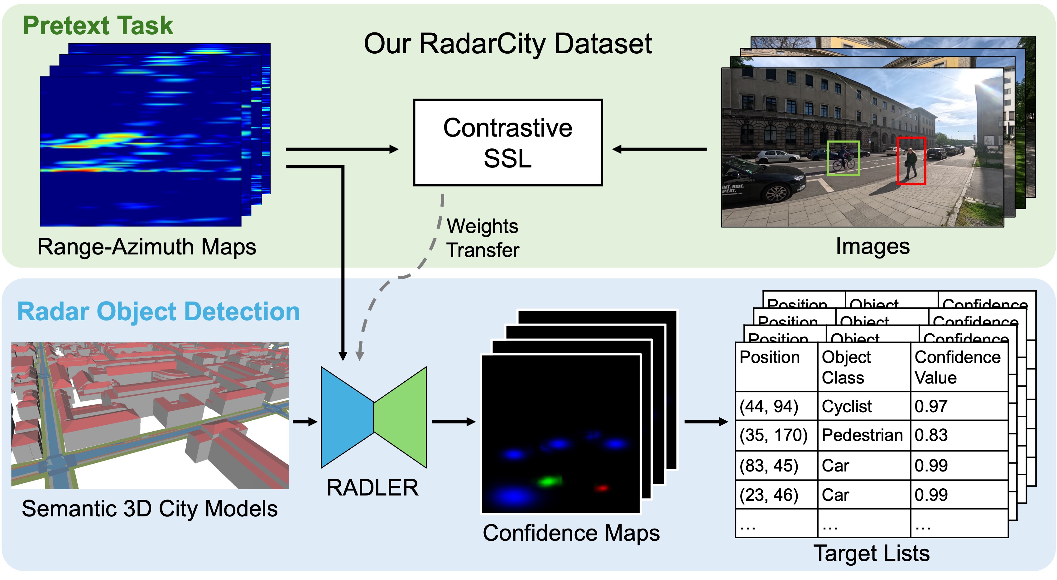
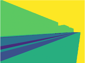
To bridge this gap, we first introduce RadarCity, a new dataset comprising 54K synchronized radar-image pairs enriched with semantic 3D city models at Technical University of Munich, Germany. The data are filtered to contain only pedestrians, cyclists, and cars. Furthermore, we propose RADLER, a novel RADar object detector, LEveraging readily available semantic 3D city models as prior information and a SSL strategy, as shown in Fig. 1.
Inspired by Alloulah et al. [3], we first propose a pretext radar-image task to learn robust radar representations against the images using a contrastive SSL strategy. Then, we apply a simple yet effective fusion strategy to insert the semantic and depth information from the easily accessible semantic 3D city models. Specifically, we process RA maps and classify objects via confidence maps (ConfMaps), with the optional fusion of semantic and depth information from semantic-depth maps (SDM). Experiments on our RadarCity dataset show that our approach achieves a mAP of 90.69% and a mAR of 95.28% without SDM, with performance being further improved by 4.17% and 0.67%, respectively, when SDM are incorporated. RADLER demonstrates superior detection accuracy compared to baseline radar object detection network (RODNet) models, highlighting the benefits of integrating semantic 3D city models with radar data.
Our contributions are summarized as follows:
-
•
To the best of our knowledge, we are the first to leverage easily accessible and standardized semantic 3D city models to assist radar-based object detection. To support this, we set up a new dataset, RadarCity, comprising 54K synchronized radar-image pairs with semantic 3D city models being used to generate SDM for all scenes.
-
•
We introduce a radar object detection method based on contrastive SSL, RADLER, which effectively learns representations from radar data and improves detection accuracy.
-
•
We enhance radar object detection performance by effectively incorporating semantic and geometric information from semantic 3D city models.
2 Related Works
Contrastive self-supervised learning Contrastive SSL captures comprehensive feature representations by exploring not only a single modality but the inherent spatial and temporal relationships between different data modalities. SimCLR represents a simple framework for contrastive SSL [9]. It unleashes the potential of representation learning from large-scale image data without annotations. MoCo [15] introduced a dynamic dictionary incorporating a queue and momentum-updated parameters, significantly reducing hardware requirements while maintaining competitive performance in representation learning. Different downstream tasks in computer vision, such as object detection [25, 44, 5], semantic segmentation [17, 48], and 3D vision [1, 42, 31], also leverage the representations learned to achieve exceptional performance. \Acclip applies contrastive SSL to text-image pairs to caption images [29]. In [4], videos are clustered based on their audio information using a contrastive SSL model trained on video-audio data. Additionally, Text2Loc [42] establishes correspondences between 3D point clouds of objects and textual descriptions using a contrastive learning approach.
Contrastive self-supervised radar-image learning Owing to the temporal relationship between radar and image data, utilizing contrastive SSL is an ideal method to combine them. In [3], the authors apply contrastive SSL on radar-image data from the CRUW dataset. The learned representations of different object classes on the RA maps exhibit distinct clusters when visualized with t-SNE. The effectiveness of contrastive SSL on radar-image data is further validated in [2] using both synthetic and empirical datasets. However, the intrinsic differences still exist between image and radar data. Recent [13] implemented and evaluated radar-specific data augmentation methods to address this issue.
Interoperable semantic 3D city models To structure semantic, geometric, topological, and appearance information for cities and landscapes, the City Geography Markup Language (CityGML) standard has become established internationally [19]. The standard defines a conceptual data model and is issued by the Open Geospatial Consortium (OGC). \Accitygml is based on the standards from the ISO 191XX series of geographic information standards, which are widely used by geographic information systems. Due to the absolute georeferencing with standardized spatial reference systems, accurate distance and area calculations can be carried out for entire cities and countries while taking the curvature of the earth into account.
In CityGML version 3.0, objects can be geometrically represented at levels of detail (LOD) 0 to 3. For example, building models in LOD0 are typically represented by their footprint, and in LOD1, by prismatic 3D solids. While LOD2 building models comprise realistic but generalized roofs and facades, LOD3 include detailed roof and facade structures. At the granularity level lane, the street space is decomposed into lane-specific traffic spaces and areas with predecessor-successor information [21, 7]. The complete building stock in LOD2 of Germany, Poland, Switzerland, and large parts of Japan is provided and maintained with stable identifiers as open CityGML datasets by public authorities. Since these datasets are commonly based on the official cadastre, the georeferencing accuracy is in the centimeter range [30]. As of 2024, a total of 216.5 million building models are available as open CityGML datasets worldwide, with an increasing number of transportation models [40]. The current trends also show that more data is expected to be released owing to open data policies and novel reconstruction methods [39, 43, 36, 26, 33].
3 Our RADLER
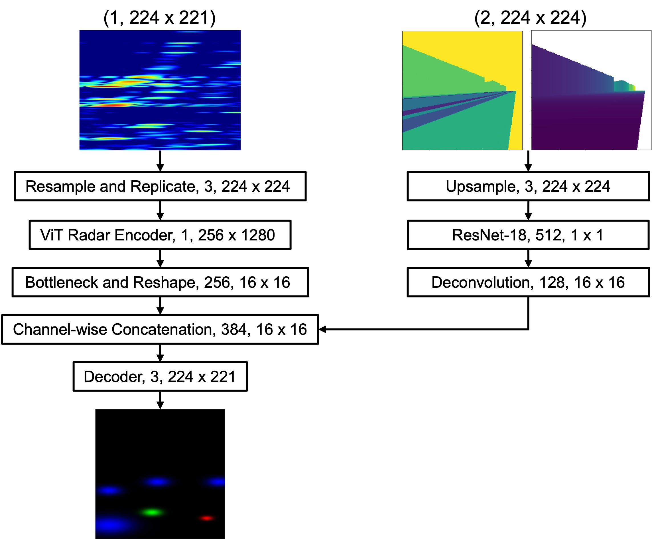
RADLER’s workflow is illustrated in Fig. 3. \Acra maps are processed using the contrastive SSL framework, MoCo [15], in the pretext task to learn comprehensive representations against the images. These representations are transferred to the radar object detection task, where they can be fused with semantic and depth information, stored as SDM, from semantic 3D city models. RADLER outputs ConfMaps to classify and localize the objects. \Aclnms is applied on the ConfMaps to extract target lists, which are evaluated against ground truth (GT) for average precision (AP) and average recall (AR).
3.1 Prior Information Selection
To determine which prior information from the CityGML model could potentially enhance radar object detection, we analyze the movement pattern of objects on the RA map. Consecutive RA maps are animated to track the trajectories of the moving objects, represented as lines in distinct colors.
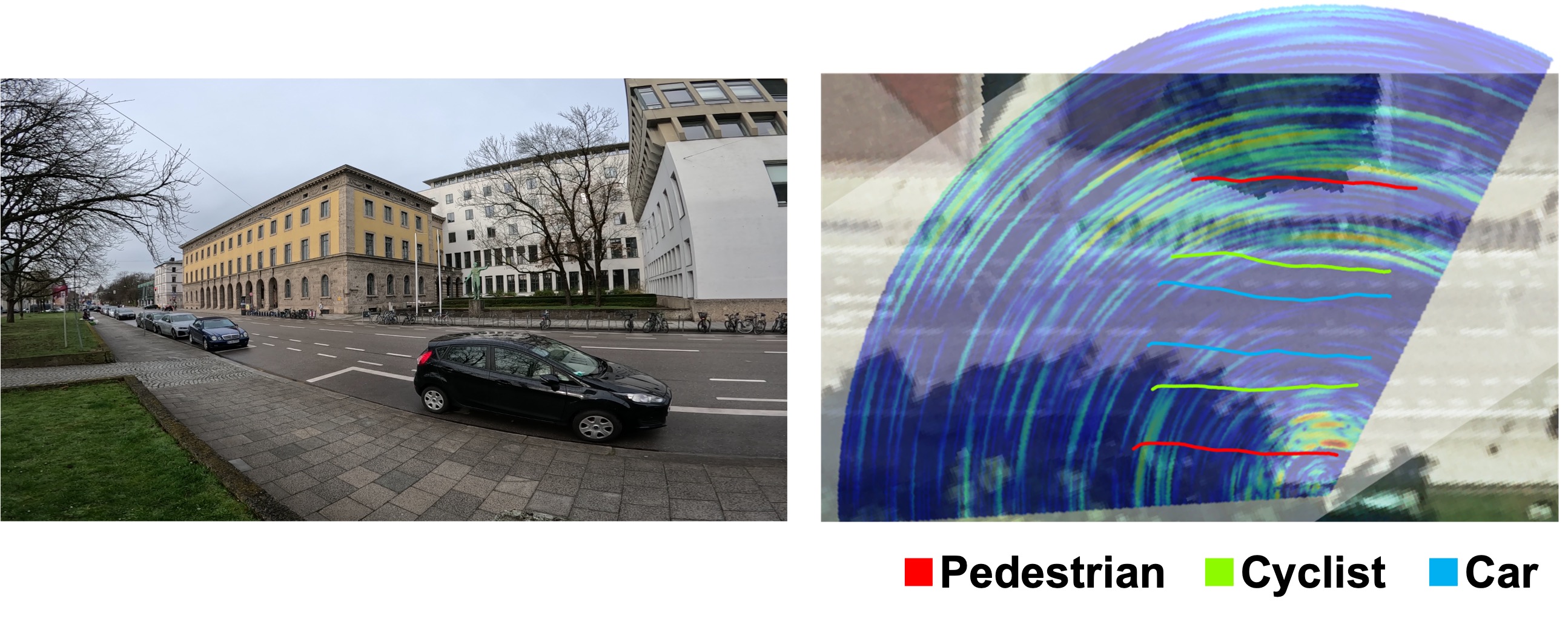
The results, shown in Fig. 2, demonstrate the accurate spatial registration of the tracked objects’ trajectories by superimposing the RA map onto a scaled and oriented BEV of the street. The RA map’s origin is precisely aligned with the sensor’s deployment point with an offset of 10 centimeters, ensuring accurate georeferencing. Notably, the trajectories of different objects are observed to be nearly parallel, reflecting the linear nature of the traffic flow. Furthermore, these trajectories accurately align with the actual traffic lanes depicted in the BEV, confirming their correct spacing and distance from the sensor’s deployment point.
This precise alignment validates the reliability of the RA map in representing the movement of objects within the street environment. We anticipate enhancing this representation by incorporating prior information about the street layout derived from semantic 3D city models, further improving the accuracy and contextual understanding of radar object detection.
Based on the process used to generate Fig. 2, two types of information are identified as crucial for accurately constructing traffic lanes on the RA map: semantic and depth information. Semantic information provides contextual details about different types of traffic objects, while depth information ensures traffic lanes’ correct positioning and spacing from the device’s perspective.
3.2 Model Architecture and Design
Contrastive SSL involves two key stages: pretext and downstream tasks. The pretext task aims to establish comprehensive representations of the input data, which are then utilized in the downstream task for specific purposes.
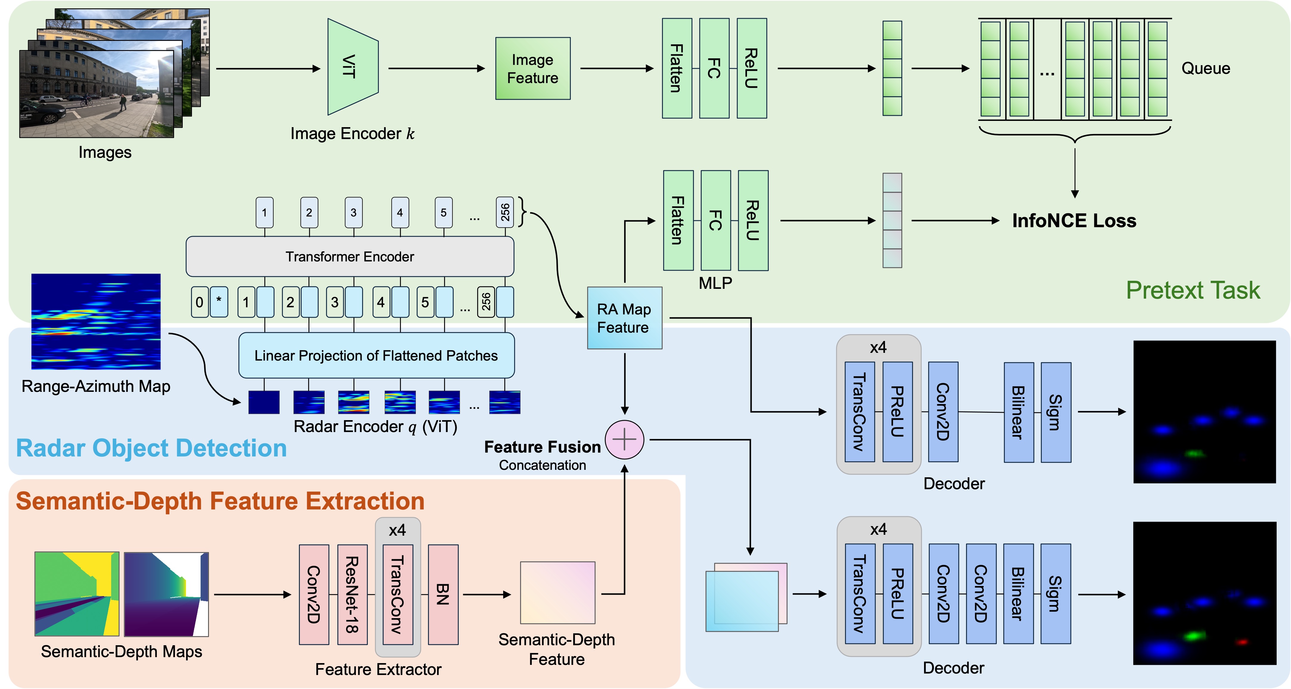
As shown in Fig. 3, for the pretext task, we adopt MoCo [15] by using Vision Transformer (ViT) [11] as the base encoder for both image and radar data. ViT is chosen due to its proven effectiveness in image-related tasks [6, 23], aligning well with the image-like nature of RA maps. The encoders are initialized with weights pre-trained on ImageNet-1K data and fine-tuned during the training. The encoded features are further processed by a multi-layer perceptron (MLP) to reduce dimensionality before calculating the contrastive loss using the InfoNCE loss function:
| (1) |
where denotes the image samples stored in the queue, with representing the positive sample, and are the negative samples. refers to the RA maps.
The cosine similarity function, , is used to calculate the similarities between RA maps and images, with as the temperature hyperparameter. The InfoNCE loss function encourages our model to associate the representation of a RA map more closely with its positive than negative images.
During training, backpropagation updates the radar branch, while the parameters of the image branch are updated using the momentum mechanism:
| (2) |
Here, represents the parameters of the encoder and MLP on the image branch, and denotes the parameters of the encoder and MLP on the radar branch. is the momentum coefficient that controls the smoothness of ’s updates. At step , the parameters are updated based on the previous parameters and the current parameters .
In the downstream task of radar object detection, the radar encoder trained during the pretext task is transferred. The encoded feature is decoded into ConfMaps, with an option to incorporate semantic-depth features extracted from SDM using ResNet-18 [14] as the feature extractor. Each channel in the ConfMaps corresponds to one object class, and each pixel value represents the likelihood of an object of that class being present at that location. The predicted ConfMaps are compared with the GT ConfMaps using the binary cross-entropy (BCE) loss function:
| (3) |
here, represents the GT ConfMaps. represents the predicted ConfMaps. cls stands for the object’s class label. is the pixel’s coordinates.
4 RadarCity Dataset
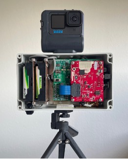
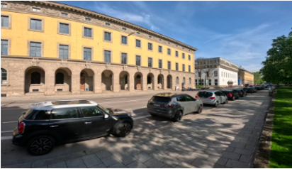
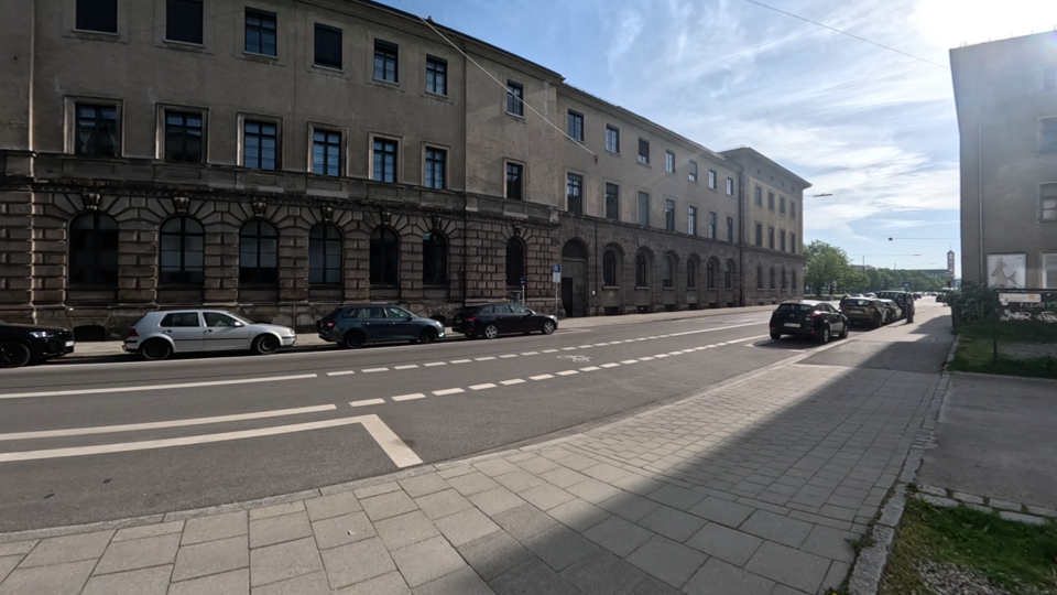
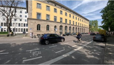
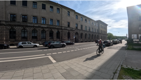
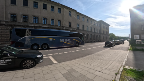
The lack of support for semantic 3D city models in existing radar-image datasets necessitates the creation of a dedicated dataset for our research. For the area around the Technical University of Munich (TUM) university campus, comprehensive CityGML models exist, as shown in Fig. 4: While LOD2 building models are provided by the state mapping agency for the entire country, lane-level street models, tree models, and LOD3 building models are available within the TUM2TWIN project [34]. Consequently, we collect the RadarCity dataset there using the setup shown in Fig. 5(a), which includes a camera and a FMCW radar. The AWR1843Boost radar has been widely used in research due to its high integration, affordability, strong performance, and comprehensive development support. To suit the requirements of our use case, we adapt the waveform parameters to achieve an unambiguous range of . Moreover, we use an effective chirp bandwidth of , with chirps per frame and time division multiplexing (TDM) multiple-input multiple-output (MIMO) coding on the two transmit and four receive antennas to obtain a virtual linear horizontal array of eight receive antennas. This leads to a range resolution of and an angular resolution of . The optimal standard deviations for a target with signal-to-noise ratio (SNR) are for the range and for the angle estimation.
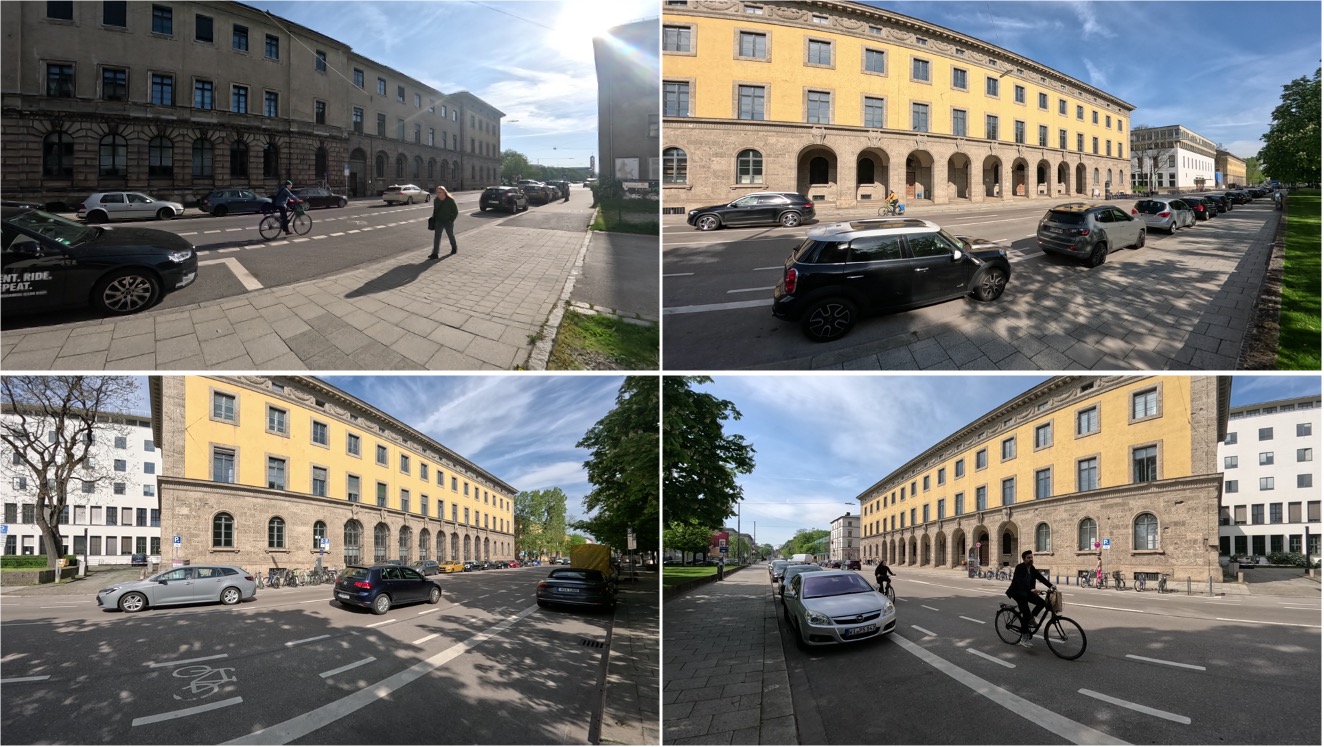
The data collection is conducted stationarily, resulting in 54K camera and radar data pairs across four scenes. The data are manually filtered to include only pedestrians, cyclists, and cars. Sample data are visualized in Fig. 5(b). Contrastive SSL alleviates the need for annotating data for the pretext task, which takes up 80% of the data. The remaining 20% is annotated manually for the downstream radar object detection task. This annotated portion is further split into training and testing datasets using an 80%-20% ratio.
5 Experiments
5.1 Prior Information Extraction
To extract semantic and depth information, the objects in the CityGML models are grouped based on their semantic attributes. For instance, traffic lanes are categorized by lane types, with lanes of the same type grouped and stored individually.
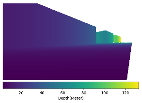
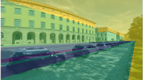
We perform raycasting on the semantic 3D city models using Open3D [47]. Furthermore, we use a point cloud scan of the TUM area to determine the precise location and orientation of the device. The generated depth and semantic maps from raycasting are presented in Fig. 6(a) and Fig. 6(b). To validate the precision, the semantic map is overlaid on the camera image (Fig. 6(d)).
Fig. 6(a) and Fig. 6(b) comprehensively demonstrate the raycasting results. However, in practice, we apply a depth-based mask to exclude semantic and depth information beyond 35 meters, which corresponds to the radar’s maximum detection range. This ensures that SDM contain only the most relevant information for radar object detection.
5.2 Fusion Ablation Studies
Common fusion methods for radar-image data include addition, mean and multiplication, concatenation, and attention mechanism [45]. These techniques inspire our exploration of radar-SDM fusion using addition and concatenation methods.

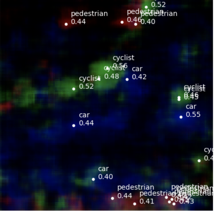
To evaluate the effectiveness of different fusion strategies, we visualize the predicted ConfMaps generated by our RADLER on the unseen test data, as shown in Fig. 8. Detected objects are marked by white dots, each labeled with the predicted object class and confidence score. When we perform radar-SDM fusion using element-wise addition, unexpected ghost targets appear throughout the predicted ConfMaps. These artifacts likely arise because adding SDM overly influences the radar object detection process. This leads to spurious predictions, indicating that element-wise addition may not be suitable for fusing radar and SDM features in this context.
We then experiment with channel-wise concatenation. By empirically fine-tuning the number of channels to be concatenated in each data modality, we find that this fusion method produces more reliable results. Fig. 8(e) demonstrates that channel-wise concatenation effectively preserves the prediction quality while integrating additional information from SDM.
Although channel-wise concatenation appears promising based on visual inspection, a conclusive evaluation of RADLER with the finalized configuration shown in Fig. 9, using mAP and mAR, is required to quantify the effectiveness of the radar-SDM fusion approach.
5.3 Radar Object Detection Results
| Models | mAP | mAR | ||||||
|---|---|---|---|---|---|---|---|---|
| RADLER (Without SDM) | 90.69 | 91.94 | 90.93 | 88.87 | 95.28 | 95.88 | 95.58 | 93.49 |
| RADLER (With SDM) | 94.86 | 95.89 | 95.41 | 92.68 | 95.95 | 96.64 | 96.23 | 94.19 |
| RODNet-CDC | 89.31 | 89.56 | 89.45 | 88.21 | 92.87 | 93.33 | 93.14 | 91.49 |
| RODNet-HG | 89.74 | 90.46 | 90.21 | 87.72 | 95.26 | 95.96 | 95.51 | 93.63 |
| RODNet-HGwI | 83.14 | 83.75 | 83.56 | 81.38 | 89.17 | 89.75 | 89.48 | 87.65 |
From ConfMaps to target lists, we adopt the same method used by RODNet, namely location-based non-maximum suppression (L-NMS). L-NMS tries to ensure each object is represented by one detection and hence to reduce false positives. It first detects all the peaks, defined as local maxima in a sliding window, in each channel of the ConfMaps. A peak threshold filters out any peaks with a lower confidence score than the threshold. The OLS values among the remaining peaks are then calculated, which is defined mathematically as follows:
| (4) |
where is the distance between two detections, is the detection’s distance to the device, and is a per-class constant which represents the error tolerance for object class cls. If the OLS value of two peaks exceeds the specified threshold, the one with the lower confidence score is suppressed, as they are likely to represent the same object. Otherwise, they are retained as valid detections for different objects. This threshold is empirically chosen to ensure the best performance of our RADLER and RODNet.
With target lists, mAP and mAR are calculated. Another use case of OLS values is determining whether a prediction is positive or negative. The OLS values between the predicted results and the GT annotations are calculated. Then, different OLS thresholds are applied, from 0.5 to 0.9, with a step size of 0.05. The mAP and mAR are the average values of AP and AR under all OLS thresholds within this range. We compare RADLER with three RODNet models, 3D Convolution-Deconvolution (RODNet-CDC), 3D stacked hourglass (RODNet-HG), and 3D stacked hourglass with temporal inception (RODNet-HGwI). Tab. 1 shows the quantitative evaluation results. and represent precision and recall under a specific OLS threshold.
Our RADLER, fused with SDM, achieves the highest performance among all models, with significant gains in both mAP and mAR. Compared to RODNet-CDC, RADLER achieves relative improvements of 6.22% in mAP and 3.31% in mAR, demonstrating robust detection capabilities across various OLS values. It also shows improvements of 5.46% in mAP and 3.51% over the average performance of RODNet models. Even without SDM, RADLER outperforms RODNet-CDC, highlighting the effectiveness of contrastive SSL on radar-image data. Among baseline models, RODNet-HG slightly improves upon RODNet-CDC in recall but still falls short of RADLER’s performance. Conversely, RODNet-HGwI shows the weakest results, reinforcing RODNet’s limitations in radar object detection and underscoring the advantages of RADLER.
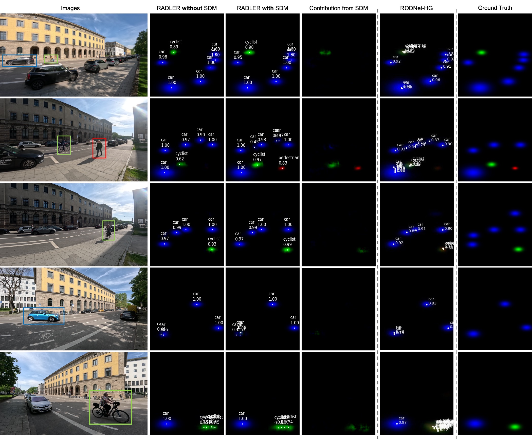
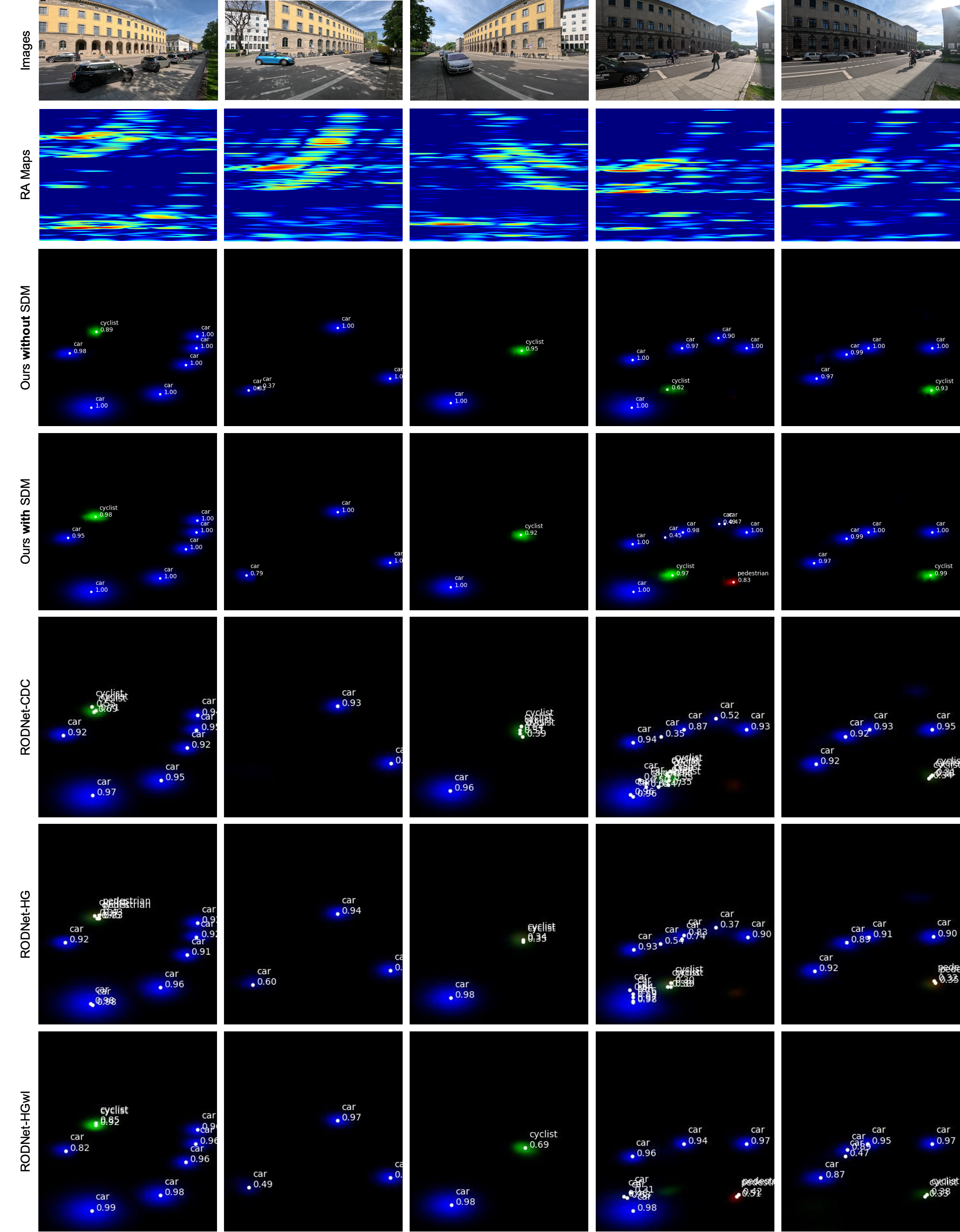
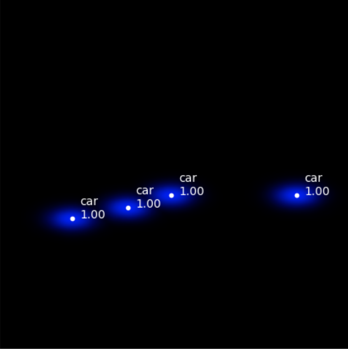
Our RADLER’s advantage over RODNet is further demonstrated in the visualized results (Fig. 10). RODNet-HG, as the best-performing RODNet variant, tends to produce duplicate detections for the same object. In contrast, our RADLER, both with and without SDM, produces fewer duplicate detections with higher confidence scores, suggesting more distinct and localized object representations on the ConfMaps. For example, in the \nth3 row in Fig. 10, RADLER detects the cyclist with confidence scores exceeding 0.9, while RODNet-HG produces detection with a confidence score of only around 0.35. In the last row, RADLER can effectively reduce duplicate detection compared to RODNet-HG in cases where the object is close to our device.
5.4 Ablation Study
By comparing the first two rows in Tab. 1, the performance gain by introducing SDM in RADLER is significant. Incorporating SDM results in a 4.17% improvement in mAP and a 0.67% increase in mAR compared to RADLER without SDM. The performance boost is consistent across different OLS values, indicating a steady contribution from SDM. These results confirm the effectiveness of incorporating semantic-depth features into RA maps and demonstrate a clear advantage over existing RODNet models.
The claim is further evidenced in Fig. 10 where SDM has increased the confidence scores of the cyclists in all three examples. In the second example, the pedestrian is detected by RADLER fusing SDM with a high confidence score, to which SDM contribute substantially. Moreover, SDM aids in detecting the car in the middle of three parked vehicles across the street, which RADLER without SDM fails to identify. The contribution from SDM is also apparent when visualizing the difference between ConfMaps from RADLER with and without SDM.
However, SDM do not always contribute to the detection. In the first and second examples, cars detected by RADLER with SDM have slightly lower confidence scores. Despite these occasional limitations, the overall advantage of fusing SDM is clearly demonstrated.
5.5 Evaluation on the CRUW dataset
The autoencoder-based RODNet-CDC’s encoder and decoder are detachable. We train the encoder of RODNet-CDC using the same method shown in Fig. 3. To validate the viability of contrastive SSL on radar-image data, we compare the performance of RODNet-CDC trained in both supervised and self-supervised manners on the CRUW dataset.
Training Method Peak = 0.3 Peak = 0.8 Peak = 0.9 mAP mAR mAP mAR mAP mAR Supervised 68.62 74.91 38.26 41.23 2.41 2.07 Self-supervised 44.04 49.96 31.23 34.28 17.95 19.11
The results are shown in Tab. 2. When the peak threshold in L-NMS is low (0.3), RODNet-CDC trained with supervised learning shows a noticeable performance advantage over the self-supervised version. However, as the threshold increases to 0.8, the performance gap narrows. At a high peak threshold of 0.9, RODNet-CDC trained self-supervised demonstrates a significant performance lead, achieving 15.54% and 17.04% improvements in mAP and mAR, respectively, over its supervised counterpart.
Peak threshold in L-NMS represents requirements for detection quality, with higher values demanding more precise detections. The self-supervised RODNet-CDC’s superior performance at high thresholds further supports our findings from the RadarCity dataset: contrastive SSL enables the model to produce more distinct and localized object representations on the ConfMaps than supervised training. This highlights the potential of self-supervised learning to improve detection quality, especially for challenging cases requiring high confidence.
The RODNet-CDC trained self-supervised shows promise; however, its overall performance may improve with larger training datasets, as contrastive SSL benefits from extensive data. Additionally, the architecture of the RODNet-CDC is relatively simple and may limit its ability to learn comprehensive representations. Prior studies such as SimCLR [9] and MoCo [15] have demonstrated that more complex architecture can better utilize contrastive loss to generate richer and more generalizable features. Nevertheless, this study validates the effectiveness of contrastive SSL for radar-image data and highlights its potential for further exploration.
6 Conclusion and Limitation
This paper introduces RADLER, a novel radar object detection method developed under contrastive SSL, which leverages prior information from semantic 3D city models for more accurate and noise-robust performance.
Semantic-depth features extracted from SDM are fused with RA map features, yielding notable performance improvements (5.46% in mAP and 3.51% in mAR on average). We observe that the introduced RadarCity dataset, containing 54K synchronized radar-image data pairs, offers unique and, to date, the only possibility to test and develop semantic-map-based radar object detection methods. Evaluation on the CRUW dataset further validates the potential of contrastive SSL for radar object detection. While challenges such as improved data synchronization, automated annotation methods, and group object detection remain, this work highlights the effectiveness of combining semantic 3D city models with radar data. It provides a solid foundation for future advancements in radar object detection.
Acknowledgments The work was conducted within the framework of the Leonhard Obermeyer Center at TUM. We are grateful for the diligent work of the TUM2TWIN members and happily support this open data initiative with our data.
References
- Achituve et al. [2021] Idan Achituve, Haggai Maron, and Gal Chechik. Self-supervised learning for domain adaptation on point clouds. In Proceedings of the IEEE/CVF winter conference on applications of computer vision, pages 123–133, 2021.
- Alloulah and Arnold [2023] Mohammed Alloulah and Maximilian Arnold. Look, radiate, and learn: Self-supervised localisation via radio-visual correspondence. In Proceedings of the IEEE/CVF Conference on Computer Vision and Pattern Recognition, pages 17430–17440, 2023.
- Alloulah et al. [2022] Mohammed Alloulah, Akash Deep Singh, and Maximilian Arnold. Self-supervised radio-visual representation learning for 6g sensing. In ICC 2022-IEEE International Conference on Communications, pages 1955–1961. IEEE, 2022.
- Alwassel et al. [2020] Humam Alwassel, Dhruv Mahajan, Bruno Korbar, Lorenzo Torresani, Bernard Ghanem, and Du Tran. Self-supervised learning by cross-modal audio-video clustering. Advances in Neural Information Processing Systems, 33:9758–9770, 2020.
- Baek et al. [2020] Kyungjune Baek, Minhyun Lee, and Hyunjung Shim. Psynet: Self-supervised approach to object localization using point symmetric transformation. In Proceedings of the AAAI Conference on Artificial Intelligence, pages 10451–10459, 2020.
- Bao et al. [2023] Fan Bao, Shen Nie, Kaiwen Xue, Yue Cao, Chongxuan Li, Hang Su, and Jun Zhu. All are worth words: A vit backbone for diffusion models. In Proceedings of the IEEE/CVF conference on computer vision and pattern recognition, pages 22669–22679, 2023.
- Beil and Kolbe [2024] Christof Beil and Thomas H. Kolbe. Applications for Semantic 3D Streetspace Models and Their Requirements—A Review and Look at the Road Ahead. ISPRS International Journal of Geo-Information, 13(10):363, 2024.
- Chamseddine et al. [2021] Mahdi Chamseddine, Jason Rambach, Didier Stricker, and Oliver Wasenmuller. Ghost target detection in 3d radar data using point cloud based deep neural network. In 2020 25th International Conference on Pattern Recognition (ICPR), pages 10398–10403. IEEE, 2021.
- Chen et al. [2020] Ting Chen, Simon Kornblith, Mohammad Norouzi, and Geoffrey Hinton. A simple framework for contrastive learning of visual representations. In International conference on machine learning, pages 1597–1607. PMLR, 2020.
- Choi et al. [2019] Jae-Woo Choi, Si-Jung Ryu, and Jong-Hwan Kim. Short-range radar based real-time hand gesture recognition using lstm encoder. IEEE Access, 7:33610–33618, 2019.
- Dosovitskiy [2020] Alexey Dosovitskiy. An image is worth 16x16 words: Transformers for image recognition at scale. arXiv preprint arXiv:2010.11929, 2020.
- Grill et al. [2020] Jean-Bastien Grill, Florian Strub, Florent Altché, Corentin Tallec, Pierre Richemond, Elena Buchatskaya, Carl Doersch, Bernardo Avila Pires, Zhaohan Guo, Mohammad Gheshlaghi Azar, et al. Bootstrap your own latent-a new approach to self-supervised learning. Advances in neural information processing systems, 33:21271–21284, 2020.
- Hao et al. [2024] Yiduo Hao, Sohrab Madani, Junfeng Guan, Mohammed Alloulah, Saurabh Gupta, and Haitham Hassanieh. Bootstrapping autonomous driving radars with self-supervised learning. In Proceedings of the IEEE/CVF Conference on Computer Vision and Pattern Recognition, pages 15012–15023, 2024.
- He et al. [2016] Kaiming He, Xiangyu Zhang, Shaoqing Ren, and Jian Sun. Deep residual learning for image recognition. In Proceedings of the IEEE conference on computer vision and pattern recognition, pages 770–778, 2016.
- He et al. [2020] Kaiming He, Haoqi Fan, Yuxin Wu, Saining Xie, and Ross Girshick. Momentum contrast for unsupervised visual representation learning. In Proceedings of the IEEE/CVF conference on computer vision and pattern recognition, pages 9729–9738, 2020.
- Hong et al. [2020] Ziyang Hong, Yvan Petillot, and Sen Wang. Radarslam: Radar based large-scale slam in all weathers. In 2020 IEEE/RSJ International Conference on Intelligent Robots and Systems (IROS), pages 5164–5170. IEEE, 2020.
- Hoyer et al. [2021] Lukas Hoyer, Dengxin Dai, Yuhua Chen, Adrian Koring, Suman Saha, and Luc Van Gool. Three ways to improve semantic segmentation with self-supervised depth estimation. In Proceedings of the IEEE/CVF conference on computer vision and pattern recognition, pages 11130–11140, 2021.
- Huang et al. [2024] Xun Huang, Ziyu Xu, Hai Wu, Jinlong Wang, Qiming Xia, Yan Xia, Jonathan Li, Kyle Gao, Chenglu Wen, and Cheng Wang. L4dr: Lidar-4dradar fusion for weather-robust 3d object detection. arXiv preprint arXiv:2408.03677, 2024.
- Kolbe et al. [2021] Thomas H. Kolbe, Tatjana Kutzner, Carl Stephen Smyth, Claus Nagel, Carsten Roensdorf, and Charles Heazel. OGC City Geography Markup Language (CityGML) Part 1: Conceptual Model Standard v3.0, 2021.
- Kraus et al. [2020] Florian Kraus, Nicolas Scheiner, Werner Ritter, and Klaus Dietmayer. Using machine learning to detect ghost images in automotive radar. In 2020 IEEE 23rd International Conference on Intelligent Transportation Systems (ITSC), pages 1–7. IEEE, 2020.
- Kutzner et al. [2020] Tatjana Kutzner, Kanishk Chaturvedi, and Thomas H. Kolbe. CityGML 3.0: New functions open up new applications. PFG – Journal of Photogrammetry, Remote Sensing and Geoinformation Science, 2020.
- Li et al. [2021] Xinyu Li, Yuan He, Francesco Fioranelli, and Xiaojun Jing. Semisupervised human activity recognition with radar micro-doppler signatures. IEEE Transactions on Geoscience and Remote Sensing, 60:1–12, 2021.
- Li et al. [2022] Yanghao Li, Hanzi Mao, Ross Girshick, and Kaiming He. Exploring plain vision transformer backbones for object detection. In European conference on computer vision, pages 280–296. Springer, 2022.
- Liu et al. [2020a] Chenwen Liu, Shengheng Liu, Cheng Zhang, Yongming Huang, and Haiming Wang. Multipath propagation analysis and ghost target removal for fmcw automotive radars. In IET International Radar Conference (IET IRC 2020), pages 330–334. IET, 2020a.
- Liu et al. [2020b] Songtao Liu, Zeming Li, and Jian Sun. Self-emd: Self-supervised object detection without imagenet. arXiv preprint arXiv:2011.13677, 2020b.
- Lo et al. [2024] Kyle Shih-Huang Lo, Jörg Peters, and Eric Spellman. Roofdiffusion: Constructing roofs from severely corrupted point data via diffusion. In European Conference on Computer Vision, pages 38–57. Springer, 2024.
- Nabati and Qi [2019] Ramin Nabati and Hairong Qi. Rrpn: Radar region proposal network for object detection in autonomous vehicles. In 2019 IEEE International Conference on Image Processing (ICIP), pages 3093–3097. IEEE, 2019.
- Nabati and Qi [2021] Ramin Nabati and Hairong Qi. Centerfusion: Center-based radar and camera fusion for 3d object detection. In Proceedings of the IEEE/CVF Winter Conference on Applications of Computer Vision, pages 1527–1536, 2021.
- Radford et al. [2021] Alec Radford, Jong Wook Kim, Chris Hallacy, Aditya Ramesh, Gabriel Goh, Sandhini Agarwal, Girish Sastry, Amanda Askell, Pamela Mishkin, Jack Clark, et al. Learning transferable visual models from natural language supervision. In International conference on machine learning, pages 8748–8763. PMLR, 2021.
- Roschlaub and Batscheider [2016] Robert Roschlaub and Joachim Batscheider. An INSPIRE-conform 3D building model of Bavaria using cadastre information, LiDAR and image matching. The International Archives of the Photogrammetry, Remote Sensing and Spatial Information Sciences, XLI-B4:747–754, 2016.
- Sanghi [2020] Aditya Sanghi. Info3d: Representation learning on 3d objects using mutual information maximization and contrastive learning. In Computer Vision–ECCV 2020: 16th European Conference, Glasgow, UK, August 23–28, 2020, Proceedings, Part XXIX 16, pages 626–642. Springer, 2020.
- Singh et al. [2019] Akash Deep Singh, Sandeep Singh Sandha, Luis Garcia, and Mani Srivastava. Radhar: Human activity recognition from point clouds generated through a millimeter-wave radar. In Proceedings of the 3rd ACM Workshop on Millimeter-wave Networks and Sensing Systems, pages 51–56, 2019.
- Tang et al. [2025] Wenzhao Tang, Weihang Li, Xiucheng Liang, Olaf Wysocki, Filip Biljecki, Christoph Holst, and Boris Jutzi. Texture2LoD3: Enabling LoD3 Building Reconstruction With Panoramic Images. https://arxiv.org/abs/2504.05249, 2025.
- TUM2TWIN team [2023] TUM2TWIN team. TUM2TWIN. https://tum2t.win/, 2023. [Accessed 27-11-2024].
- Wang et al. [2021] Yizhou Wang, Zhongyu Jiang, Xiangyu Gao, Jenq-Neng Hwang, Guanbin Xing, and Hui Liu. Rodnet: Radar object detection using cross-modal supervision. In Proceedings of the IEEE/CVF Winter Conference on Applications of Computer Vision, pages 504–513, 2021.
- Wang et al. [2024] Yuefeng Wang, Wei Jiao, Hongchao Fan, and Guoqing Zhou. A framework for fully automated reconstruction of semantic building model at urban-scale using textured lod2 data. ISPRS Journal of Photogrammetry and Remote Sensing, 216:90–108, 2024.
- Wu et al. [2024] Qiangqiang Wu, Yan Xia, Jia Wan, and Antoni B Chan. Boosting 3d single object tracking with 2d matching distillation and 3d pre-training. In European Conference on Computer Vision, pages 270–288. Springer, 2024.
- Wysocki et al. [2022] Olaf Wysocki, Benedikt Schwab, and Bruno Willenborg. Oloocki/awesome-citygml: Release, 2022.
- Wysocki et al. [2023] Olaf Wysocki, Yan Xia, Magdalena Wysocki, Eleonora Grilli, Ludwig Hoegner, Daniel Cremers, and Uwe Stilla. Scan2LoD3: Reconstructing semantic 3D building models at LoD3 using ray casting and Bayesian networks. IEEE/CVF Conference on Computer Vision and Pattern Recognition Workshops (CVPRW), pages 6547–6557, 2023.
- Wysocki et al. [2024] Olaf Wysocki, Benedikt Schwab, Christof Beil, Christoph Holst, and Thomas H Kolbe. Reviewing open data semantic 3d city models to develop novel 3d reconstruction methods. The International Archives of the Photogrammetry, Remote Sensing and Spatial Information Sciences, 48:493–500, 2024.
- Xia et al. [2023] Yan Xia, Qiangqiang Wu, Wei Li, Antoni B Chan, and Uwe Stilla. A lightweight and detector-free 3d single object tracker on point clouds. IEEE Transactions on Intelligent Transportation Systems, 24(5):5543–5554, 2023.
- Xia et al. [2024] Yan Xia, Letian Shi, Zifeng Ding, Joao F Henriques, and Daniel Cremers. Text2loc: 3d point cloud localization from natural language. In Proceedings of the IEEE/CVF conference on computer vision and pattern recognition, pages 14958–14967, 2024.
- Xu et al. [2024] Yajin Xu, Juilson Jubanski, Ksenia Bittner, and Florian Siegert. Roof plane parsing towards lod-2.2 building reconstruction based on joint learning using remote sensing images. International Journal of Applied Earth Observation and Geoinformation, 133:104096, 2024.
- Yang et al. [2021] Ceyuan Yang, Zhirong Wu, Bolei Zhou, and Stephen Lin. Instance localization for self-supervised detection pretraining. In Proceedings of the IEEE/CVF Conference on Computer Vision and Pattern Recognition, pages 3987–3996, 2021.
- Yao et al. [2023] Shanliang Yao, Runwei Guan, Xiaoyu Huang, Zhuoxiao Li, Xiangyu Sha, Yong Yue, Eng Gee Lim, Hyungjoon Seo, Ka Lok Man, Xiaohui Zhu, et al. Radar-camera fusion for object detection and semantic segmentation in autonomous driving: A comprehensive review. IEEE Transactions on Intelligent Vehicles, 2023.
- Zhang et al. [2018] Zhenyuan Zhang, Zengshan Tian, and Mu Zhou. Latern: Dynamic continuous hand gesture recognition using fmcw radar sensor. IEEE Sensors Journal, 18(8):3278–3289, 2018.
- Zhou et al. [2018] Qian-Yi Zhou, Jaesik Park, and Vladlen Koltun. Open3d: A modern library for 3d data processing. arXiv preprint arXiv:1801.09847, 2018.
- Ziegler and Asano [2022] Adrian Ziegler and Yuki M Asano. Self-supervised learning of object parts for semantic segmentation. In Proceedings of the IEEE/CVF Conference on Computer Vision and Pattern Recognition, pages 14502–14511, 2022.
Supplementary Material
7 RadarCity Dataset
7.1 Sensor and Device Setup
The sensor platform for collecting the dataset contains a GoPro HERO11 Black camera and a 77GHz FMCW mmWave radar from Texas Instrument, model AWR1843Boost. The radar’s field of view (FoV) after post-processing is 1-33.7m, ±60° horizontally. The GoPro camera uses the ultra-wide mode to enable a horizontal FoV of also ±60°. The frame rate of the camera recording is 30 frames per second (FPS), and for the radar, it is 15 FPS.
Attempts have been made to record radar data at 30 FPS to facilitate data alignment. However, under our radar configuration, the radar data recording could only last around five minutes at 30 FPS due to limited bandwidth for data transmission. The collected radar data is initially stored in the onboard storage and then transmitted to the computer via Ethernet, as depicted in Fig. 11. However, there is a mismatch in the data collection and transmission rate, causing the onboard storage to be filled up after a certain time. Subsequently, any collected data beyond the storage capacity will be abandoned, leading to data loss. To maintain data integrity, it is required to reduce the frame rate of the radar data recording to 15 FPS.
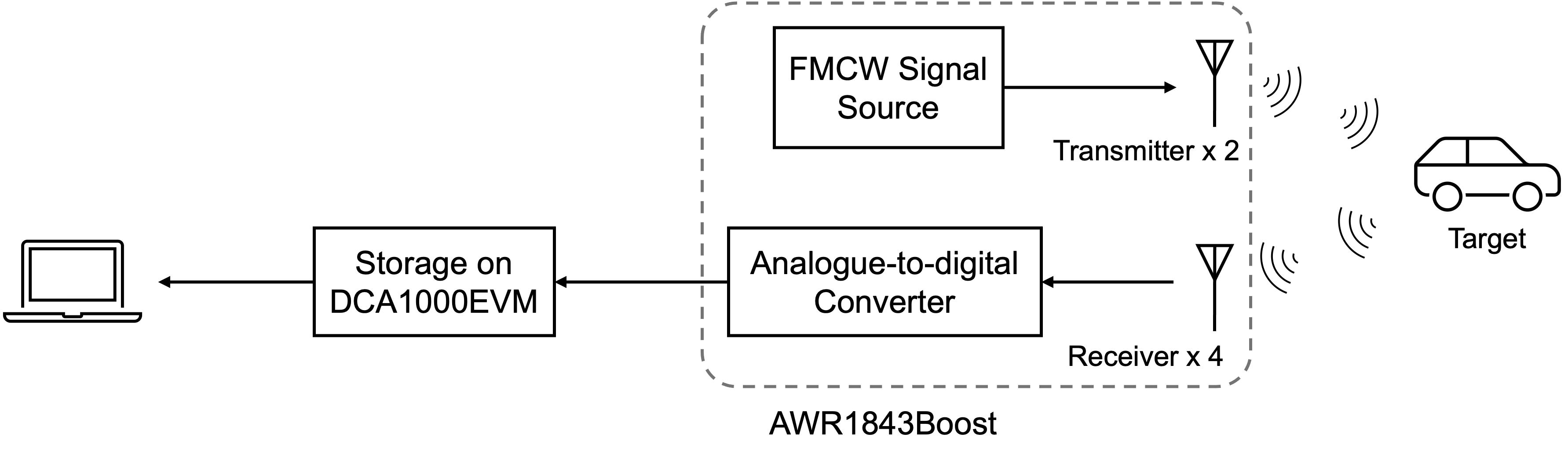
However, to ensure that every second camera image frame matches a radar frame, it is essential to start recording simultaneously on both the camera and radar. The proposed method uses a synchronized software trigger to start the recording on both devices. For the GoPro camera, a lab firmware is available, offering the functionality to synchronize the built-in clock of the GoPro camera with the computer’s system clock. Additionally, the GoPro camera can start recording automatically at a given time.
The radar board is controlled through mmWave Studio, a GUI from Texas Instruments that allows configuration and control of mmWave sensor modules and collection of analog-to-digital data for offline analysis. A script has been developed to read the computer’s system clock so the buttons to trigger the radar data recording can be clicked at a specified time.
As a result, the GoPro camera and radar can be triggered to record data automatically and simultaneously based on the computer’s system clock.
7.2 Data Clusters
After collecting the data, they are organized into clusters based on object types and their positions in the scene. Tab. 3 shows detailed information about the data clusters. Data clusters 1 and 2 contain three common objects on the street: pedestrians, cyclists, and cars. These objects are also the targets of interest in many other machine learning models for radar object detection.
| Data Cluster | Object Classes | Objects’ Position | Number of Data Pairs |
|---|---|---|---|
| 1 | pedestrians, cyclists, and cars | In the corresponding lanes | |
| 2 | pedestrians, cyclists, and cars | Not in the corresponding lanes | |
| 3 | Besides mentioned above, trucks, vans, scooters, motorbikes, and bicycles for delivery, etc. | May or may not be in the corresponding lanes |
Data cluster 1 and 2 are further split based on where those objects are. Fig. 12(a) shows an example of data cluster 1 where the cars are on the driving lane, and a cyclist is riding on the bicycle lanes. Fig. 12(b), an example data from data cluster 2, contains the same object classes. However, the cyclist there is riding on the pedestrian walk instead of the bicycle lane. This separation is prepared for further analysis of how to use the prior information from the semantic 3D city models, as the initial thought is that the traffic lanes in the street model should facilitate the detection of common objects traveling on them. Objects, such as the bus in Fig. 12(c), are out of our current research interest.
7.3 Dataset Annotation Overview
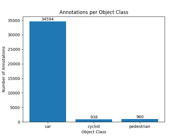
Data clusters 1 and 2 were selected for training and evaluating the performance of RADLER against the baseline RODNet models. Based on the workflow of contrastive SSL, the data in data clusters 1 and 2 are further split into the pretext and downstream task datasets. The pretext task dataset has around radar-image data pairs, while the downstream task dataset has data pairs with for training and for testing. Although SSL can save the efforts of annotating the pretext task dataset, the downstream task dataset still needs to be annotated. In this case, the downstream task dataset is purely manually annotated, hence incurring some offsets in the annotations despite great carefulness. The distribution of the annotations of different object classes in the downstream dataset is presented in Fig. 13. More cars are annotated than pedestrians and cyclists since those cars are annotated repeatedly among the radar data frames.
8 Evaluation Results
8.1 Impact of OLS in L-NMS
The OLS value used in L-NMS is chosen through an experimental evaluation. The results of mAP and mAR for RADLER and RODNet under different OLS values as thresholds for L-NMS are shown in Fig. 14. An observation applied for all is that mAP and mAR improve as the OLS value increases.
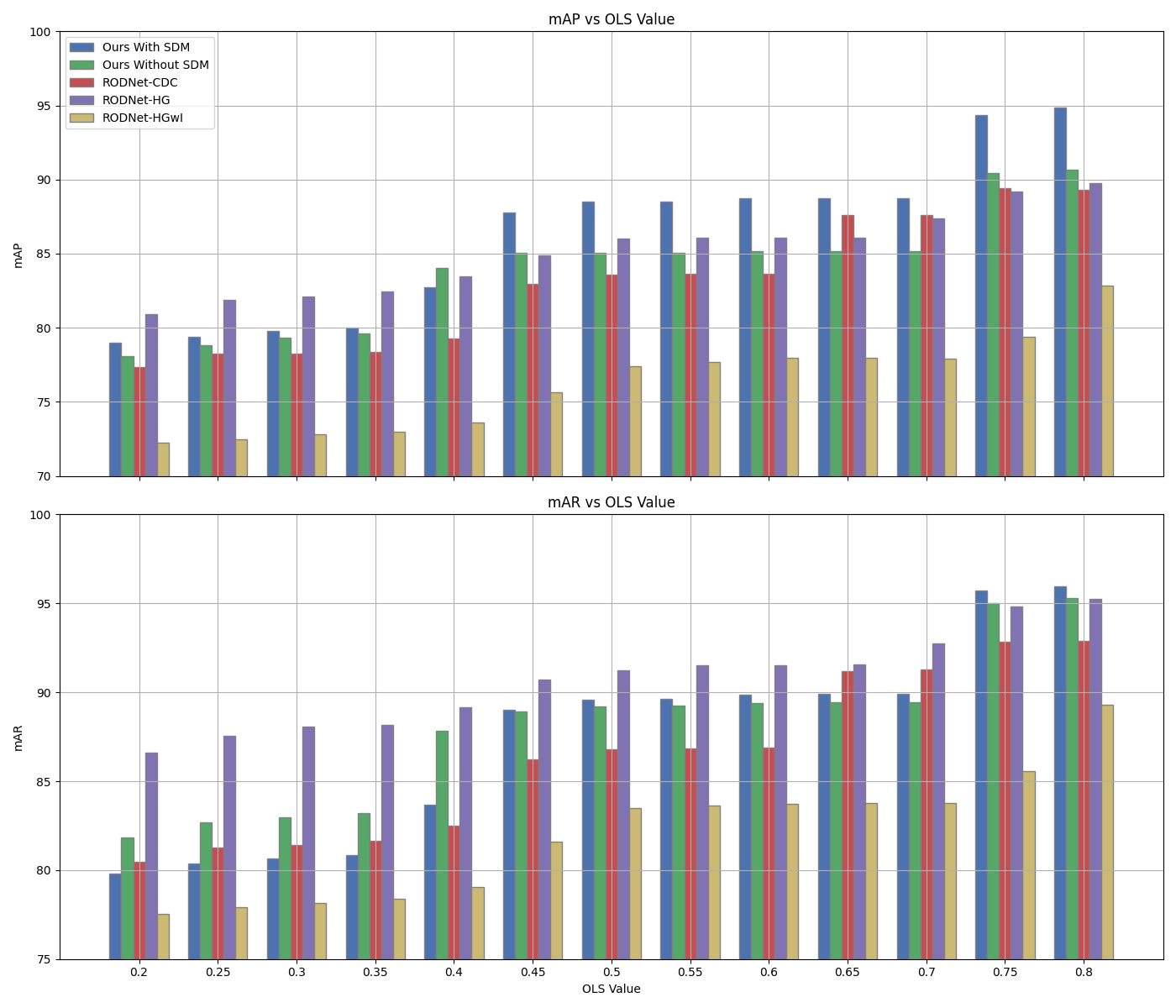
Notably, RODNet-HG performs better than other models at lower OLS values (from to ). This suggests that RODNet-HG produces more separated peaks in the ConfMaps, leading to fewer overlaps and, therefore, lower similarities between the peaks to have them survive the L-NMS. As the OLS value increases, RADLER, particularly the variant integrated with SDM, starts to outperform the others, with its advantage becoming most apparent at an OLS value of , where it achieves a mAP of nearly % and a mAR of around %.
While the exact reasons for this performance trend across different OLS values may not be immediately clear, this experiment highlights how the distribution of confidence values in the ConfMaps varies across models. The same OLS threshold applied to different models yields different target lists, indicating the differences in how the confidence values of a detected object from different models are numerically distributed on the ConfMaps, resulting in the quality of the target list generated through L-NMS.
8.2 Additional Qualitative Results
Fig. 15 shows more visualized detection results from the test data. Here, the OLS value for L-NMS is set to be for all models. RADLER demonstrates a clear advantage over the RODNet models. As shown in every column, RADLER can produce a more accurate and confident detection for each object as the RODNet models tend to produce redundant detection for one object with lower confidence values.
In the \nth1 column, SDM contribute to the detection of the cyclist by increasing its confidence score by . Also, in the last column, the usage of SDM increases the confidence of the detected cyclist by .
However, SDM are not always contributive. In the \nth1 column, the detected car on the left in the middle of the street is lower in confidence score compared to the detection from RADLER without SDM. Also, in the \nth3 column, SDM have lowered the confidence of the detected cyclist by .