ST-Booster: An Iterative SpatioTemporal Perception Booster for Vision-and-Language Navigation in Continuous Environments
Abstract
Vision-and-Language Navigation in Continuous Environments (VLN-CE) requires agents to navigate unknown, continuous spaces based on natural language instructions. Compared to discrete settings, VLN-CE poses two core perception challenges. First, the absence of predefined observation points leads to heterogeneous visual memories and weakened global spatial correlations. Second, cumulative reconstruction errors in three-dimensional scenes introduce structural noise, impairing local feature perception. To address these challenges, this paper proposes ST-Booster, an iterative spatiotemporal booster that enhances navigation performance through multi-granularity perception and instruction-aware reasoning. ST-Booster consists of three key modules — Hierarchical SpatioTemporal Encoding (HSTE), Multi-Granularity Aligned Fusion (MGAF), and Value-Guided Waypoint Generation (VGWG). HSTE encodes long-term global memory using topological graphs and captures short-term local details via grid maps. MGAF aligns these dual-map representations with instructions through geometry-aware knowledge fusion. The resulting representations are iteratively refined through pretraining tasks. During reasoning, VGWG generates Guided Attention Heatmaps (GAHs) to explicitly model environment-instruction relevance and optimize waypoint selection. Extensive comparative experiments and performance analyses are conducted, demonstrating that ST-Booster outperforms existing state-of-the-art methods, particularly in complex, disturbance-prone environments.
Index Terms:
Vision-and-language navigation, robot navigation, map learning.Vision-and-Language Navigation in Continuous Environments demands robust perception to navigate reconstructed real-world scenes under observational noise. This paper presents ST-Booster, a practical solution that enhances scene understanding by combining global layout tracking with local detail mapping. ST-Booster maintains fused spatiotemporal environmental representations by integrating navigation memory with real-time fine-grained observations, which are further aligned with linguisitc instructions. It autonomously identifies instruction-relevant regions via predicted heatmaps to inform path planning decisions. This multi-scale perception strategy significantly improves navigation robustness in noisy, cluttered indoor environments. To support real-world applications, we open-source the code of ST-Booster, enabling its deployment in indoor autonomous navigation tasks for robotics practitioners.
I Introduction
Vision-and-Language Navigation (VLN) is an interdisciplinary indoor embodied task [1, 2, 3] that seeks to develop intelligent robots to navigate complex environments based on natural language instructions. Traditionally, VLN frameworks operate within discrete environments, where robots move only between predefined waypoints. In contrast, VLN in continuous environments (VLN-CE) [4, 5], trains robots to navigate smoothly in continuous spaces through small, incremental actions. Although VLN-CE offers a more realistic scenario for navigation tasks, it also introduces substantial challenges. Firstly, the absence of the predefined navigation graphs compels agents to establish long-term spatiotemporal dependencies through diverse visual observations at arbitrary positions. Secondly, the inherent visual noise in continuous environments during three-dimensional (3D) reconstruction severely compromises local observation accuracy. These factors collectively necessitate enhanced spatiotemporal perception capabilities for robust visual interpretation and trajectory-instruction alignment.
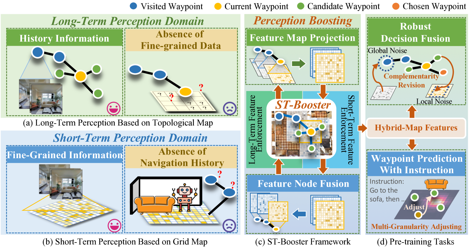
Current approaches for VLN-CE are broadly categorized into end-to-end methods and the map-based methods. End-to-end methods implicitly learn environmental perceptions through RGB-D image processing [8, 9], facing challenges in preserving fine-grained spatial details and long-term history due to feature compression. Map-based methods have emerged as solutions for achieving effective environmental perception, owing to their inherent advantages in structured representation [10, 11, 12]. Particularly, as shown in Figure 1 (a), topological mapping techniques [6, 13, 14, 15] address long-term dependencies by constructing graph representations, however, they often oversimplify the local representations. Conversely, grid-based methods [7, 16] in Figure 1 (b) excel in capturing detailed local features but face the challenge of computational efficiency for large-scale environments. Recent hybrid strategies attempt to synergize these complementary map representations. Initial efforts [17] directly combined two different map features through averaging operations, which diluted critical spatial relationships. Subsequent advancements [18] introduced multi-scale fusion mechanisms. However, the prevailing late-fusion paradigm inherits limitations from individual map representations.
To address these perception challenges in VLN-CE, we propose ST-Booster, an iterative spatiotemporal enhancement method with three core components illustrated in Figure 2. First, the Hierarchical SpatioTemporal Encoding (HSTE) module decouples long- and short-term perception through complementary representations. Global topological graphs aggregate historical trajectory patterns to establish structured global memory, while local grid maps employ deformable projections to capture fine-grained environmental details. Second, Multi-Granularity Aligned Fusion (MGAF) module bridges these heterogeneous representations via bidirectional cross-domain fusion. Specifically, topological nodes are projected onto grid coordinates with spatial distribution weights to inject historical context into local features, while local details from grid maps are embedded into corresponding topological nodes through region matching to enhance global precision. Cross-modal alignment with linguistic instructions further integrates textual intent into the fused representations. Finally, this multi-granularity perception undergoes iterative optimization through several pretraining tasks, including a weakly-supervised Guided Attention Heatmap (GAH) prediction task that explicitly models environment-instruction joint probabilities through a Value-Guided Waypoint Generation (VGWG) module. VGWG predicts GAHs and utilizes them to guide the generated candidate waypoints to prioritize instruction-relevant regions, overcoming the limitation of conventional waypoint generation methods that ignore linguistic constraints. Experiments demonstrate improved navigation success rates in complex scenarios with environmental interference, compared to state-of-the-art methods evaluated on VLN-CE datasets.
The remainder of this paper is organized as follows. Section II conducts a comprehensive review of the relevant literature. The design of ST-Booster is presented in Section III. Section IV details dataset construction and presents the experimental results. Finally, Section V provides the concluding remarks.
II Related Work
In this section, we review related research on VLN-CE and environment representation in autonomous navigation. Comparison with existing literature is carried out to highlight the novel aspects of our research.
Vision-and-Language Navigation in Continuous Environments (VLN-CE). Facing the challenges of VLN-CE, researchers have explored various techniques. Initial methods for VLN-CE attempted to predict low-level actions from continuous visual observations through end-to-end training [4, 19]. However, these methods failed to effectively process historical information due to the extended navigation paths with overlapping observations. To address this limitation, researchers introduced waypoint predictors, which leverage predicted local navigation graphs to provide candidate waypoints for subsequent decision-making [20, 21, 22]. This modular approach, inspired by discrete VLN, bridges the gap between discrete and continuous environments and has been further extended with semantic information [23, 24, 25]. Nevertheless, the performance of VLN-CE is still far below VLN [26, 27]. This mainly arises from the fact that both end-to-end and modular approaches rely on implicit visual representations derived from complex inputs, hindering the understanding of spatiotemporal relationships in environments and diminishing the model’s capacity to capture the vision-textual dependencies. To overcome these challenges, this paper proposes a novel environmental perception booster that combines the structural advantages of global topological and local grid maps to explicitly model spatial-temporal relationships.
Environment Representation. Scene perception is essential for indoor navigation, offering agents visual cues and contextual insights [28, 29, 30, 31]. Traditional end-to-end training methods often lack structured constraints, leading to loss and distortion of representation. To address this issue, researchers have explored map-based approaches to effectively manage perceptual data during navigation [32, 33, 34]. For instance, Chen et al. [6] introduced a framework combining topological maps and attention mechanisms for navigation planning. In a later study [35], an online topological map is utilized to enhance the agent’s spatial comprehension. Some other approaches leverage grid maps to represent environmental details. Unlike topological graphs that compress visual representations into nodes, grid maps offer detailed local spatial information, aiding short-term decision-making [36, 37]. For instance, Georgios et al. [23] proposed a cross-modal map learning framework to enhance path prediction. Meanwhile, Huang et al. [32] integrated pre-trained vision-language features with 3D reconstruction for spatial mapping. In order to combine the strengths of topological and grid maps, hybrid map methods have been proposed. For instance, Liu et al. [17] constructed a global topological map by averaging grid map features and fused the decision results. In contrast, An et al. [18] enhanced both maps by incorporating panoramic image features and their low-dimensional representations, and improved action reasoning by combining independent decisions. However, existing hybrid map methods are still constrained by the inherent limitations of each map type without feature-level fusion. This paper proposes an iterative spatiotemporal perception booster that focuses on feature-level hybrid map fusion to achieve a more comprehensive perception and improve the model’s multi-granularity understanding of the environment.
III ST-Booster
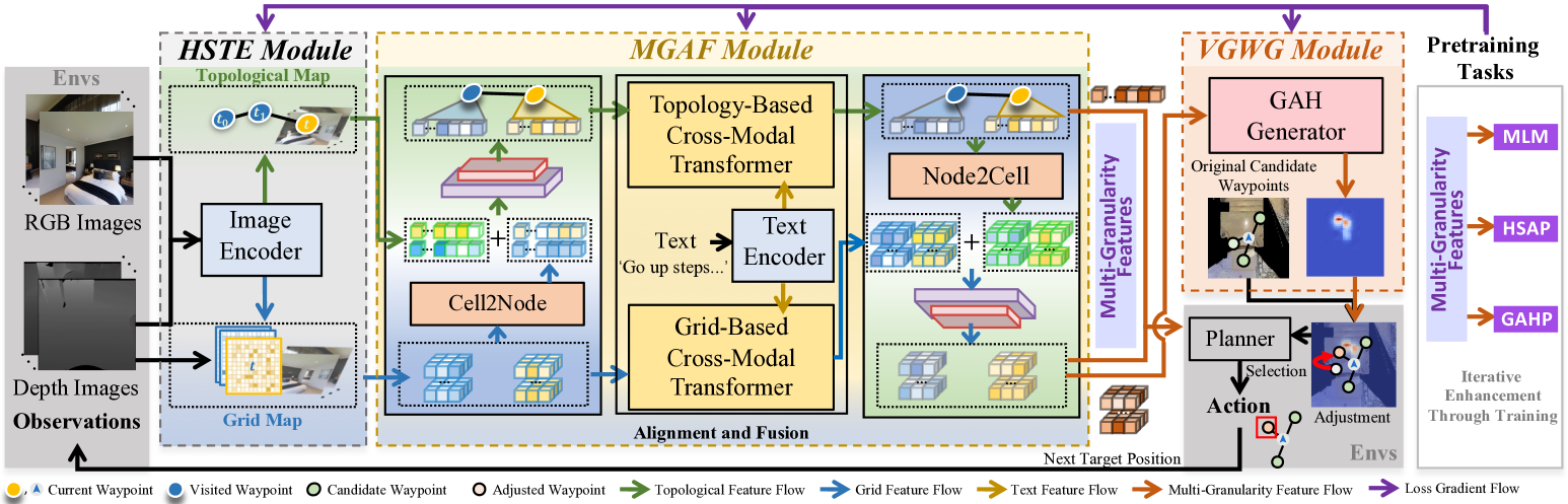
In this section, we first outline the problem formulation of VLN-CE (Section III-A). Subsequently, we introduce ST-Booster, an iteratively spatiotemporal booster to enhance agent perception in complex environments. As illustrated in Figure 2, HSTE module constructs hybrid maps by introducing global topological and local grid map representations (Section III-B). These hybrid map representations are fused and aligned with instructions through MGAF module (Section III-C). The obtained multi-granularity features are utilized in VGWG module to predict GAHs, which optimize the candidate waypoint generation with instruction-relevant knowledge (Section III-D). The multi-granularity features are iteratively refined using several pretraining tasks and then fine-tuned with online-generated maps for navigation reasoning (Section III-E).
III-A Problem Formulation
Following the conventional setting of VLN-CE [38, 18], an agent in VLN-CE receives an instruction containing words for each navigation episode. This instruction is embedded as , where represents the embedding of the -th word. During the navigation process, the agent records its position information and observes the surrounding panoramic RGB-D images at each time step . These images are taken from 12 distinct views, each oriented at a horizontal heading angle of , where . Here, and represent the RGB and depth images observed from the th view, respectively. The agent’s objective is to effectively integrate textual and visual information to navigate toward the target locations specified in the instruction. In contrast to selecting discrete waypoints, agents in VLN-CE navigate within a 3D continuous environment by choosing actions from a low-level action space defined as .
III-B Hierarchical SpatioTemporal Encoding Module
To effectively navigate complex continuous environments, we propose a hierarchical spatiotemporal encoding module that decomposes environmental representation into long-term and short-term components.
Structural Topology Encoding for Global Perception. At step , the global topological map captures long-term environmental awareness by jointly modeling visited and observed waypoints. The node set stores the visited nodes with averaged panoramic visual representations and the observed nodes with view-specific visual representations, where and , is the number of observed waypoints at th time step. In particular, the visual representations include the RGB features extracted via ViT [39] and the depth features extracted from ResNet [40]. In addition, the edge set encodes the Euclidean distances between adjacent nodes. The nodes in dynamically integrate perception context through fused relative position embeddings and time-step embeddings. Additionally, a globally connected virtual node is created to represent the ‘stop’ action. Topological maps efficiently manage global scaling and maintain historical memory, but compress the representation details. To address this, we integrate local grid maps to enrich fine-grained environmental representation.
Dense Grid Encoding for Local Perception. To represent the detailed surrounding environment, we introduce a local grid map centered on the agent’s current position, where and denote the map scale size and feature dimensions, respectively. To mitigate computational complexity, we construct using dimensionality-reduced RGB features and depth images. Leveraging the agent’s pose and depth data, the downsized RGB features are projected onto the ground grid through the spatial transformation between 2D and 3D coordinate spaces. Similar to node embeddings, for each grid cell, , in addition to introducing the projected features, we also incorporate position embeddings to capture the spacial relationships between the grid cells. Grid maps offer precise local information but are limited in scalability and historical context.
III-C Multi-Granularity Aligned Fusion Module
Although global topological and local grid maps each possess distinct perceptual advantages, their structural limitations still constrain their perception capability. Therefore, this section establishes a multi-granularity alignment fusion module, which introduces instruction-aware feature alignment to construct unified hybrid representations aligned with linguistic instructions. Meanwhile, the cross-domain fusion between long- and short-term perception domains addresses intrinsic heterogeneity in spatiotemporal feature spaces.
Instruction Feature Alignment. By interacting with instruction information, contextual understanding is embedded into domain-specific environmental perception. We adopt Topology-based Cross-Modal Transformer (TCMT) and Grid-based Cross-Modal Transformer (GCMT) [18] to facilitate the fusion of instruction cues with long-term and short-term environmental perception, respectively. Specifically, TCMT incorporates a graph-aware self-attention mechanism to integrate instructions with global topological information , producing a global-aware multi-modal graph , i.e.,
| (1) |
where NE represents the node embedding network. For GCMT, the fusion of instruction information and local spatial awareness is achieved through a self-attention mechanism for cell encoding, i.e.,
| (2) |
where represents the local-aware multi-modal grid maps and CE represents the grid cell embedding network.
This dual-stream design establishes hierarchical perception, where global topological graphs comprehend navigation context through global trajectory-linguistic correlation, while local grid maps discern fine-grained spatial-textual correspondence. However, this domain alignment creates independent representations that impede unified spatiotemporal reasoning.
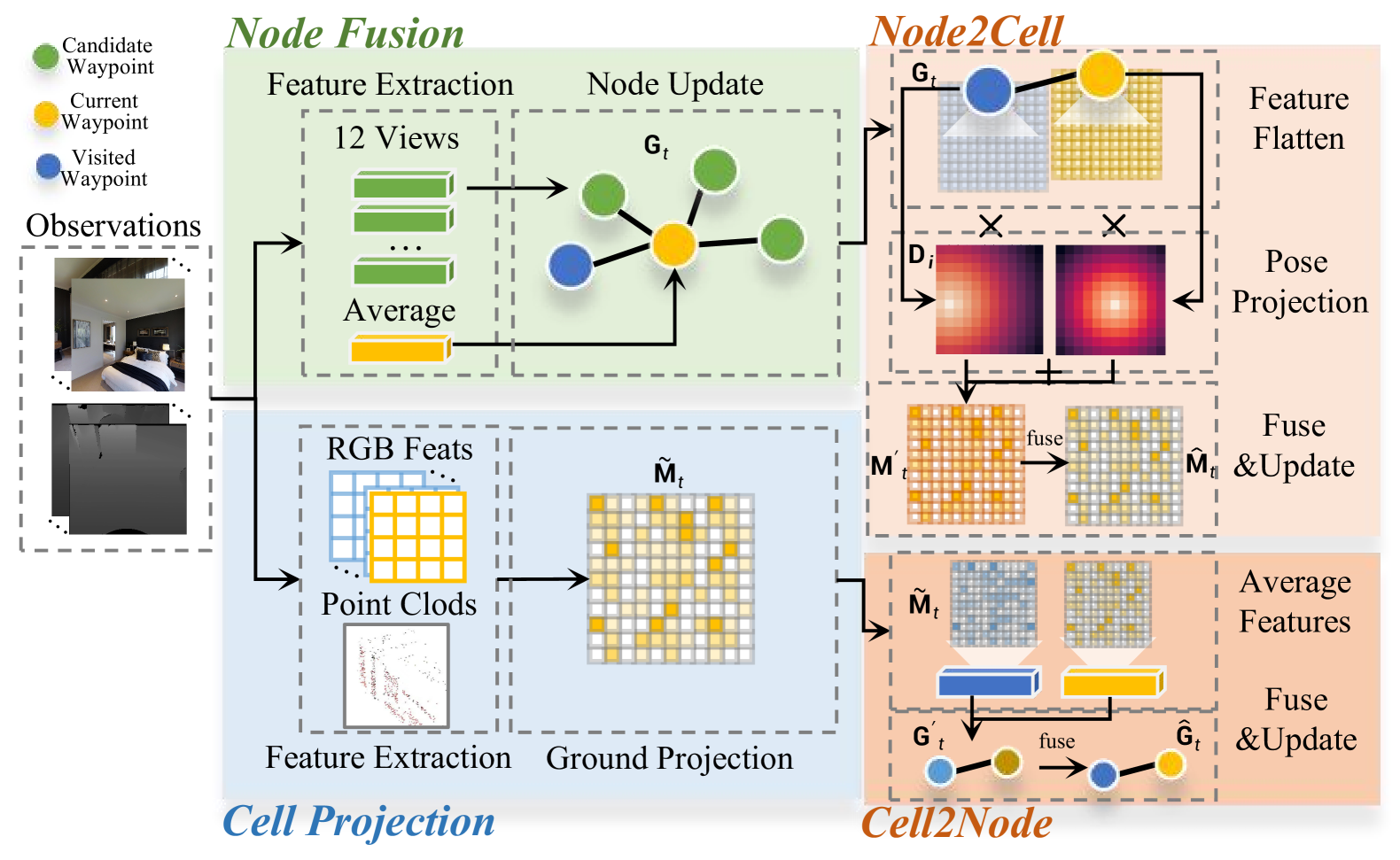
Cross-Domain Perception Fusion. To leverage the complementary strengths of both map structures, we introduce a geometrically-constrained projection operator to facilitate cross-domain knowledge sharing. The operator comprises two components, Cell2Node and Node2Cell, which project perceptual information from heterogeneous domains into a unified feature space. As depicted in the bottom-right corner of Figure 3, Cell2Node is initially utilized to transfer local grid features into the long-term topological domain. To maintain a domain-invariant structure, suitable feature migration strategies are applied based on the different node types. In particular, grid maps are aggregated to provide comprehensive environmental information for the visited nodes . As for the unvisited nodes with partly observations, we locate them on the grid cells and extract the corresponding features. With the utilization of Cell2Node, the intermediate topological map is generated, with the visited nodes and observed nodes with new representations from as follows
| (3) |
| (4) |
where average represents an expectation pooling operation, and denote the geometric coordinates of the th observed node at time step when projected onto the grid map, is the observed candidate number at step and represents the grid cell features with the coordinate in grid map . Subsequently, is fused with the original graph to form a hybrid graph, i.e.,
| (5) |
where denotes the concatenation operation, and GF is a fully-connected network fusing the integrated graph features. Subsequently, is utilized to replace the original topological map in Equation 1 with more fine-grained spatial information.
Similarly, we introduce Node2Cell to project the global historical perception of nodes into the local grid-based domain, which is shown in the upper right corner of Figure 3. To effectively capture comprehensive global context, such as task progress, we leverage linguistically-aligned topological maps with nodes in Equation 1 to facilitate cross-domain knowledge fusion. Specifically, we flatten the node features and map them back into the grid maps with same geometric positions. To reduce perceptual bias from isolated node features, we fuse multiple nodes within the grid map’s spatial boundaries, represented as , where dis calculates the Euclidean distance between two nodes, and represents the geometry size of the grid maps. We also introduce a geometric-aware discount matrix to adjust the contribution of multiple projected node features to each grid cell. Specifically, the nodes in are projected onto the current grid map with coordinates . The Euclidean distances from the th grid cell to are calculated, where the maximum and minimum distance are represented as and , respectively. Through the distance normalization, the discount matrix is obtained by . The intermediate perception integrated from the grid map is further updated from the multi-modal grid maps obtained in Equation 2, i.e.,
| (6) |
where MF serves as a fusion network of grid map features. Through bidirectional geometric-aware transformation, topological graphs enriched with geometric details, while grid maps enhanced with global context, and the multi-granularity map representations are constructed.
III-D Value-Guided Waypoint Generation Module
We introduce the guided attention heatmap (GAH) prediction task to improve model interpretation by explicitly capturing the alignment between hybrid map perception and instructions. GAH is a self-centered heatmap that predicts the 2D probability distribution of instruction-relevant regions, derived from multi-granularity grid map representations, i.e.,
| (7) |
where HFFN is a fully-connected forward network to predict GAHs. To obtain the ground truth heatmap , we approximate the relevant region based on the position of the next waypoint in the reference trajectory, without additional semantic information. Specifically, we project onto an egocentric coordinate system aligned with agent’s current heading, and smooth the located position with the Gaussian kernel. To accurately capture the relationship between the waypoint and the surrounding environment, the map’s resolution is enhanced by through grid upsampling, resulting in the higher-definition grid map. Based on the ground-truth GAHs, the weakly-supervised training method discussed in Section III-E is applied to improve the module to capture contextual cues by leveraging multi-modal cross-domain knowledge from hybrid environmental perception.
To overcome the common issue where the standard waypoint predictor [21] ignores connections between instructions and environments, we introduce GAHs to generate candidate waypoints with crucial spatial guidance considering environmental perception and language instructions. As shown in Algorithm 1, the initial waypoint distributions are predicted by the original predictor WP with only visual observations, and then refined with predicted GAHs in Equation 7 through weighted fusion. automatically adjust the distribution heatmaps and generate candidate waypoints to the area relevant to instruction with high probability. This approach improves environmental awareness of critical zones to support downstream navigation planning, balancing knowledge from both perceptual reality and task context.
III-E Pretraining and Fine-Tuning
Pretraining. To enhance the representational capability of the hybrid multi-modal maps, the following three pretraining tasks are introduced.
1) Masked Language Modeling (MLM). This task is commonly used to improve the model’s understanding of complex language structures [38]. To be specific, the words of the input instructions are randomly masked with a probability of 15%, prompting the model to predict the masked words based on contextual information. For MLM task, the prediction loss for generating the masked words is defined by
| (8) |
where is the policy parameters, and represent the masked and the unmasked portion of the instruction embeddings, respectively, and denotes the expert trajectory.
2) Hybrid Single Action Prediction (HSAP). This task aims to enhance the model’s environmental perception and instruction comprehension by improving decision-making accuracy [18]. Specifically, we utilize and to predict the long-term waypoint-selected action and short-term waypoint-selected action , respectively. Then, we fuse them to get a more robust decision. Specifically, if is among the current candidate waypoint set , we perform a weighted fusion of and with the weight ; otherwise, we directly adopt , i.e.,
| (9) |
| (10) |
After obtaining the fused actions, the HSAP loss at each single step is applied using the ground-truth target waypoints from the expert trajectories as a reference, i.e.,
| (11) |
3) Guided Attention Heatmap Prediction (GAHP). This task is trained in a weakly supervised manner, with the mean squared error (MSE) loss between the ground-truth GAH and the predicted one , i.e.,
| (12) |
| Method | Val Seen | Val Unseen | Test Unseen \bigstrut | ||||||||||||
| TL | NE () | OSR () | SR () | SPL () | TL | NE () | OSR () | SR () | SPL () | TL | NE () | OSR () | SR () | SPL () \bigstrut[t] | |
| Seq2Seq [3] | 9.26 | 7.12 | 46 | 37 | 35 | 8.64 | 7.37 | 40 | 32 | 30 | 8.85 | 7.91 | 36 | 28 | 25 |
| CM2 [23] | 12.05 | 6.10 | 51 | 43 | 35 | 11.54 | 7.02 | 42 | 34 | 28 | 13.90 | 7.70 | 39 | 31 | 24 |
| MGMap [24] | 10.12 | 5.65 | 52 | 47 | 43 | 10.00 | 6.28 | 48 | 39 | 34 | 12.30 | 7.11 | 45 | 35 | 28 |
| CWP-RecBERT [21] | 12.50 | 5.02 | 59 | 50 | 44 | 12.23 | 5.74 | 53 | 44 | 39 | 13.31 | 5.89 | 51 | 42 | 36 |
| Sim2Sim [22] | 11.18 | 4.67 | 61 | 52 | 44 | 10.69 | 6.07 | 52 | 43 | 36 | 11.43 | 6.17 | 52 | 44 | 37 |
| ETPNav [38] | 11.78 | 3.95 | 72 | 66 | 59 | 11.99 | 4.71 | 65 | 57 | 49 | 12.87 | 5.12 | 63 | 55 | 48 |
| Ego2-Map [41] | – | – | – | – | – | – | 4.94 | – | 52 | 46 | 13.05 | 5.54 | 56 | 47 | 41 |
| GridMM [7] | 12.69 | 4.21 | 69 | 59 | 51 | 13.36 | 5.11 | 61 | 49 | 41 | 13.31 | 5.64 | 56 | 46 | 39 |
| BEVBert [18] | – | – | – | – | – | – | 4.57 | 67 | 59 | 50 | – | 4.70 | 67 | 59 | 50 |
| Scale-VLN [42] | – | – | – | – | – | – | 4.80 | – | 55 | 51 | – | 5.11 | – | 55 | 50 \bigstrut[b] |
| ST-Booster (Ours) | 13.29 | 3.71 | 77 | 69 | 59 | 13.14 | 4.77 | 68 | 61 | 50 | 13.42 | 4.83 | 66 | 59 | 50 \bigstrut |
Fine-Tuning. To prevent the model from overfitting to the offline expert data, we fine-tune the pre-trained model in the continuous simulation environments with the HSAP task. During this fine-tuning process, the topological and grid maps are updated in real-time based on the agent’s observations. Additionally, we progressively transition from teacher-forcing to student-forcing during action reasoning phase [21] to balance learning stability and exploration. Specifically, in teacher-forcing strategy, the agent navigates with ground-truth actions, enabling the model to quickly learn reasonable paths toward the target, while in student-forcing strategy, the agent explores the unknown state-action space by navigating based on sampled results from the model’s output This hybrid training approach effectively balances exploration and exploitation, allowing the model to learn expert behaviors effectively.
IV Experiments
This section initially presents the experimental setup, detailing the dataset, training implementation, and evaluation metrics. Subsequently, systematic comparisons are conducted between ST-Booster and state-of-the-art baselines in VLN-CE. Through extensive experiments and analysis, we demonstrate the functional contributions of each core module in ST-Booster.
IV-A Experimental Setup
Datasets. The Matterport3D (MP3D) environment [3] with 90 scenes and 10,800 RGB-D images is commonly used for discrete VLN tasks. To enable continuous navigation, the VLN-CE benchmark reconstructs these scenes in 3D within the Habitat simulator [43], adapting the Room-to-Room (R2R) dataset [3] for continuous environments. The dataset is split into train, val seen, val unseen, and test subsets. The val seen split involves new paths and instructions within familiar training environments, while val unseen and test contain paths in novel, unseen environments. To evaluate the proposed framework’s generalization capabilities, models are typically assessed on unseen environments.
Implementation Details. The visual feature extraction of ST-Booster is based on ViT-B/16-CLIP [44], which generates representations with a dimension of 768. For grid-based spatial representations, the extracted features are downsampled to . This grid map spans an area, with each grid cell corresponding to a 1 section. The size of GAHs is , where the length of each cell is 0.2m. During pretraining, our model is initialized with pre-trained LXMERT weights [45] and undergoes 200,000 iterations of offline training using a batch size of 64. The model achieving the highest pretraining performance is subsequently fine-tuned through an additional 20,000 iterations of online training with a reduced batch size of 16. Finally, the fine-tuned model is evaluated on unseen environments, and the highest-performing variant is selected for further analysis.
Evaluation Metrics. To evaluate the performance of the proposed model, we utilized several standard metrics, including (i) Trajectory Length (TL), measuring the average path length; (ii) Navigation Error (NE), representing the average distance between the agent’s final position and the target; (iii) Oracle Success Rate (OSR), the rate at which the agent reaches a position within 3m of the target; (iv) Success Rate (SR), the rate at which the agent stops within 3m of the target; and (v) Success rate weighted by Path Length (SPL), which balances success rate with path efficiency. These metrics provide a comprehensive assessment of the model’s navigation performance on both seen and unseen splits.
IV-B Comparison with the State-of-the-Art Methods
We conducted comprehensive comparisons with several state-of-the-art approaches listed in Table I. For instance, Sim2Sim [22] and CWP-RecBERT [21] employ the end-to-end training framework to predict actions through joint modeling of vision features and historical latent variables. ETPNav [38] utilizes topological map encoding to capture historical navigation patterns and derive optimal planning trajectories. GridMM [7] implements a grid-based representation mechanism to model fine-grained environmental details for precise navigation. The method with the most comparable performance to ours is BEVBert [18], which is a hybrid map-based method. BEVBert employs separate training procedures for different map representations and then fuses the outputs from the two maps during the navigation planning phase. In contrast, ST-Booster integrates a hybrid map feature transfer and fusion mechanism. The enhanced perception is utilized to optimize both the waypoint generation and the navigation planning processes.
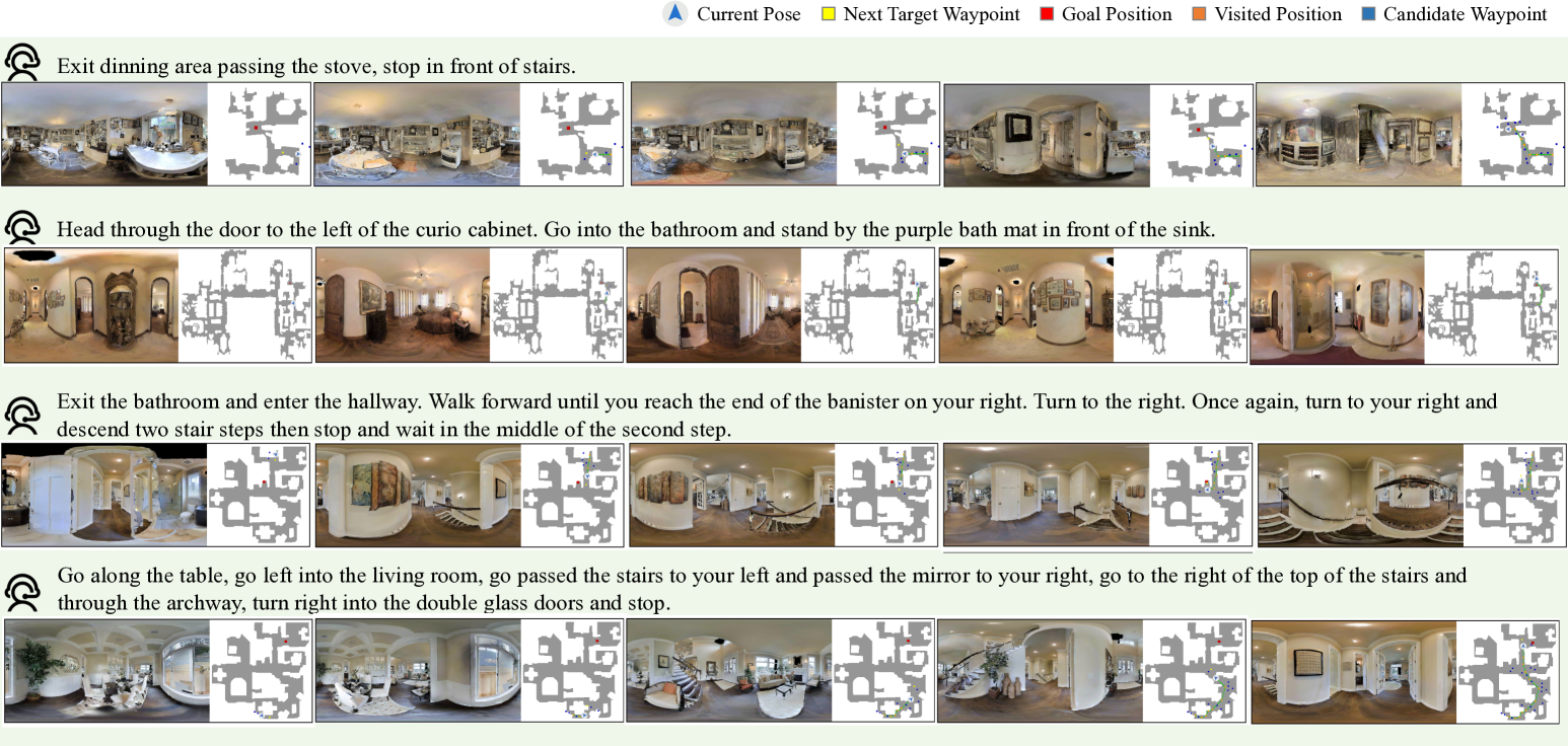
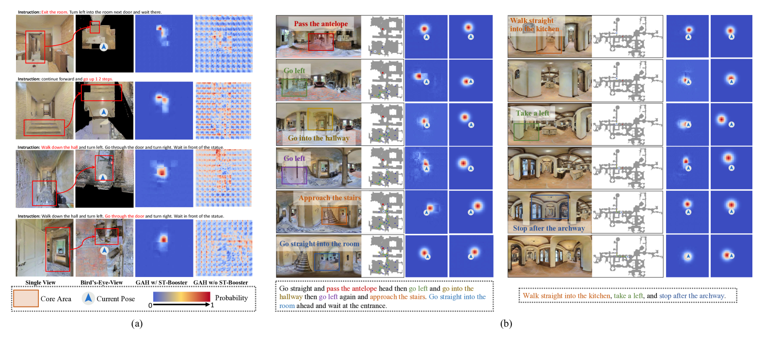
As illustrated in Table I, for the val unseen split, ST-Booster improves the highest SR (BEVBert) by 2%, indicating its superior generalization to unseen environments. In the test-unseen split, ST-Booster achieves higher SR (59%) and SPL (50%) compared to competing approaches. Furthermore, as demonstrated in Figure 4, several visualization examples with short and long instructions illustrate the navigation processes in unseen environments using ST-Booster. These examples highlight that ST-Booster, by enhancing multi-modal hybrid map perception, effectively captures spatiotemporal relationships, and improves navigation task success rates.
| Expert | MGAF | VGWG | TL | NE () | OSR () | SR () | SPL () \bigstrut |
| Topological Map | ✗ | ✗ | 13.87 | 5.24 | 61.6 | 53.6 | 43.1 \bigstrut[t] |
| ✗ | ✓ | 13.15 | 5.38 | 60.3 | 54.1 | 43.8 | |
| ✓ | ✗ | 13.46 | 5.12 | 64.4 | 55.5 | 45.2 | |
| ✓ | ✓ | 13.15 | 5.02 | 64.8 | 56.9 | 46.6 \bigstrut[b] | |
| Grid Map | ✗ | ✗ | 9.01 | 5.65 | 46.3 | 38.4 | 33.3 \bigstrut[t] |
| ✗ | ✓ | 8.64 | 5.76 | 44.8 | 38.6 | 33.6 | |
| ✓ | ✗ | 10.53 | 5.77 | 51.4 | 41.8 | 35.0 | |
| ✓ | ✓ | 10.50 | 5.70 | 52.1 | 43.0 | 36.2 \bigstrut[b] | |
| Hybrid Map | ✗ | ✗ | – | 4.57 | 67.0 | 59.0 | 50.0 \bigstrut[t] |
| ✗ | ✓ | 13.05 | 4.52 | 67.2 | 59.7 | 49.7 | |
| ✓ | ✗ | 13.22 | 4.87 | 66.7 | 59.8 | 49.3 | |
| ✓ | ✓ | 13.14 | 4.77 | 67.6 | 61.0 | 50.2 \bigstrut[b] |
IV-C Ablation Study
This ablation study aims to validate the synergistic optimization effects of the feature fusion capability of the MGAF module and the instruction-guided waypoint prediction mechanism of the VGWG module. As shown in Table II, we consider three different map experts to predict actions with or without the key modules proposed in ST-Booster, including topological, grid, and hybrid map experts. Specifically, when activating MGAF without VGWG, it improves the success rate (SR) of the topological map expert by 1.9% and the grid map expert by 3.4%. With VGWG enabled, MGAF further boosts these improvements to 2.8% and 4.6% respectively, while achieving a 2.0% SR enhancement for the hybrid map expert. These improvements confirm MGAF’s effectiveness in facilitating complementary fusion of dual-map perceptions and strengthening instruction-feature alignment, thereby benefiting both individual and hybrid experts. Furthermore, the VGWG module demonstrates its distinct value through instruction-aware waypoint distribution prediction, which focuses attention on navigation-critical regions, contributing an additional 1.2% SR gain to the hybrid expert. The combined application of both modules enables the hybrid expert to achieve optimal performance with 61.0% SR, illustrating the effectiveness of the modules within ST-Booster.
IV-D Performance Analysis
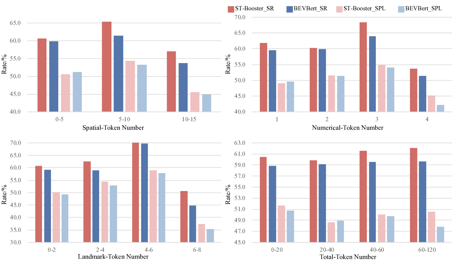
Consistency Against Task Complexity. We evaluate the generalization performance of ST-Booster in complex tasks within unseen environments, conducting a statistical analysis of the proposed framework’s performance. Task complexity is quantified based on the instruction’s complexity across four dimensions. For instance, we count the number of terms representing spatial elements and landmarks in each instruction, where a higher count indicates increased spatial complexity of the navigation task. Similarly, we analyze the frequency of numeric terms and the total vocabulary count in each instruction, reflecting the task’s cognitive difficulty in handling long-term dependencies. Experimental results in Figure 5 demonstrate that the performance of ST-Booster is consistently superior to the selected SOTA methods across all complexity dimensions. This confirms that ST-Booster effectively enhances complex spatiotemporal perception, and improves navigation performance.
Visualization of Predicted GAHs. To visually validate ST-Booster’s enhanced environmental perception, we conduct a comparative analysis of GAHs generated from both our augmented perceptual features and baseline image features. As shown in Figure 6 (a), the GAHs generated using ST-Booster effectively highlight the key regions associated with landmarks in the instructions. This indicates that leveraging the ST-Booster-enhanced environmental perception features enables improved environmental understanding and instruction alignment, capturing contextual cues from the local environment more effectively. In Figure 6 (b), we illustrate some comparisons between ground-truth and predicted GAHs during evaluation in unseen environments. In the presented examples, the ground-truth GAHs accurately reflect instruction-relevant regions in the current surroundings, while the predicted GAHs also provide similar cues to some extent. However, since GAHs represent coarse-grained information, we discourage assigning it excessive weight during utilization, as this may introduce additional errors and disrupt the decision-making process. Notably, we do not recommend using GAHs during the fine-tuning stage, as it may constrain the model’s exploration of the environment, limiting the learning performance.
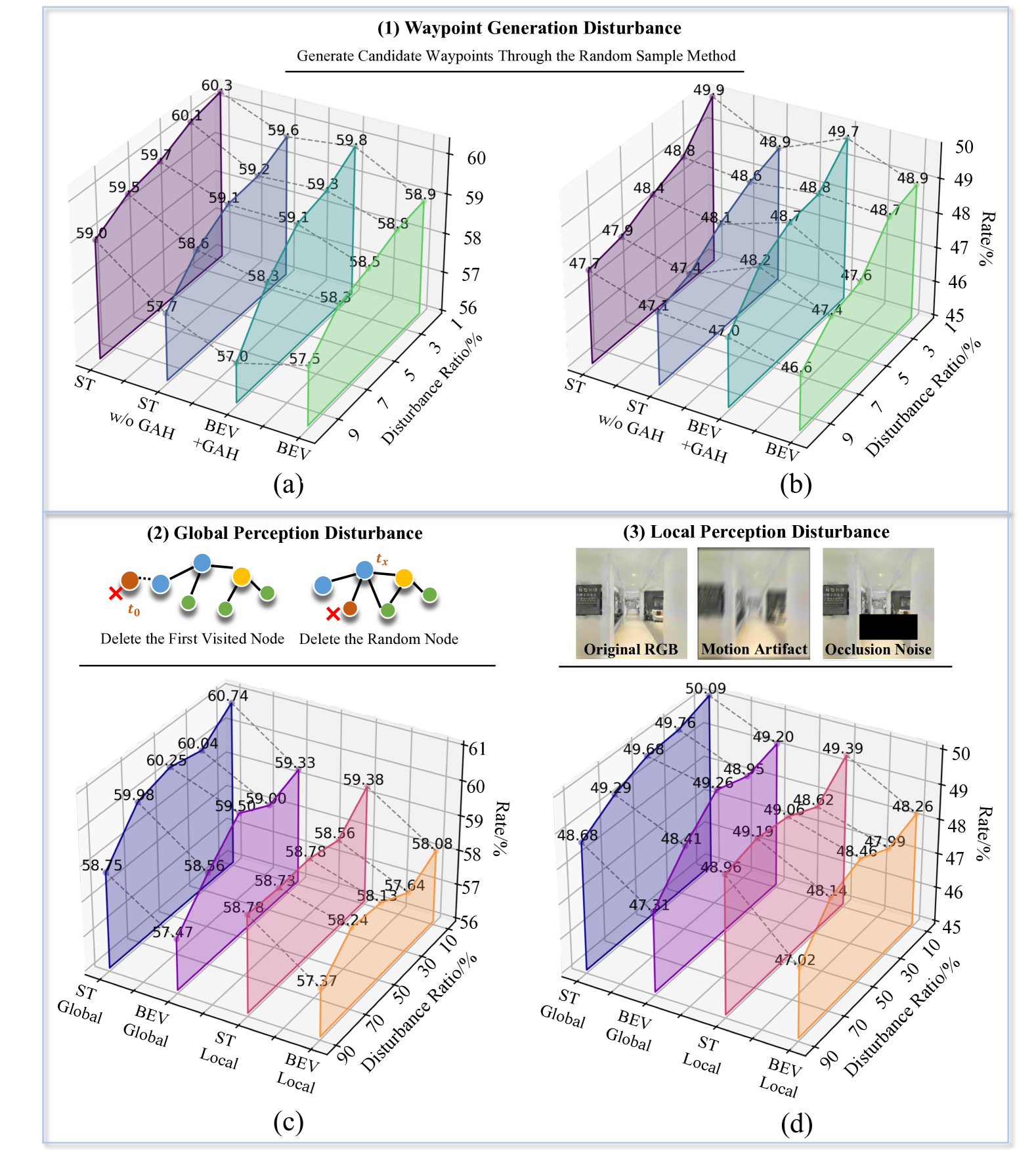
Robustness Against Disturbance. To simulate environmental interference commonly encountered in real-world scenarios, we implement several distinct types of disturbances, followed by comprehensive performance analysis. (i) Waypoint Generation Disturbance. The first experiment emulates visual perception degradation by probabilistically substituting waypoint predictions with random sampling. As shown in Figure 7 (a) and (b), our framework demonstrates waypoint disturbance tolerance, maintaining 59% SR and 47.7% SPL with waypoint disturbance ratio 9%, which is 1.5% and 1.1% higher than BEVBert baseline. This resilience originates from GAHs that compensate visual prediction errors through instruction-anchored spatial priors. (ii) Global Perception Disturbance. The second experiment evaluates hybrid perception robustness against global perception disturbance. We progressively discard historical nodes to simulate privacy-constrained memory management. As revealed in Figure 7 (c) and (d), our dual-map architecture maintains 58.75% SR and 48.68% SPL performance with global disturbance ratio 90%, outperforming the baseline by 1.28% and 1.37%, respectively. (iii) Local Perception Disturbance. In addition, we also valuate hybrid perception robustness against local perception disturbance by applying Gaussian blur kernels and random visual masking to mimic motion artifacts and occlusions. With local disturbance ratio 90% in Figure 7 (c) and (d), our method outperforms better than the baseline with 1.41% SR and 2.94% SPL. This robustness stems from cross-domain complementarity, where topological graphs preserve structural consistency through geometric detail integration from grids, while grid maps retain local accuracy via global context propagation from nodes.
IV-E Influence of Design Parameters
Grid Map Size. We analyze the effect of grid map size on navigation performance in val unseen split of VLN-CE. We evaluate different scale sizes ranged in {77, 1111, 1515} and cell resolutions in {0.5m, 1m} for grid maps. As shown in Table III, increasing the cell size generally improves navigation performance. This improvement is caused by the fact that smaller cells capture more noise and redundant details, interfering with the agent’s extraction of key environmental cues. Furthermore, when the cell resolution is 0.5m, increasing the map size boosts success rates by incorporating more environmental information. However, with a 1m cell resolution, the performance of the 1515 map declines. This is due to the excessive map size, which results in an increased region overlap between adjacent time steps. This causes redundant computations and data processing complexity. The results indicate that balancing scale size and cell resolution is crucial for optimizing navigation.
GAH Weights. As a coarse-grained expert prior, GAH is applied by multiplying it with a weight and adding it to the probability heatmap predicted by the original waypoint predictor. This experiment analyzes the sensitivity of performance on val unseen split dataset to different GAH weights. We tested three weight values, as shown in Table IV. Reducing the GAH weight from to improves most metrics. However, further reduction to slightly degrades performance. This indicates that while GAH provides useful prior knowledge, its coarse-grained nature can introduce bias limit exploration, and reduce performance. In this paper, we use a GAH weight of with the best performance for the remaining experiments.
| Scale Size | Cell Resolution | TL | NE () | OSR () | SR () | SPL () \bigstrut |
| 7 7 | 0.5m | 14.02 | 5.10 | 63.9 | 55.6 | 45.6 \bigstrut[t] |
| 1m | 12.73 | 4.80 | 63.9 | 57.2 | 47.9 \bigstrut[b] | |
| 1111 | 0.5m | 13.05 | 4.99 | 65.7 | 57.9 | 49.2 \bigstrut[t] |
| 1m | 13.14 | 4.77 | 67.6 | 61.0 | 50.2 \bigstrut[b] | |
| 1515 | 0.5m | 12.70 | 4.81 | 66.2 | 58.7 | 49.9 \bigstrut[t] |
| 1m | 13.2 | 4.78 | 66.6 | 59.8 | 48.8 \bigstrut[b] |
| GAH Weight | TL | NE () | OSR () | SR () | SPL () \bigstrut |
| 13.62 | 4.95 | 65.2 | 57.7 | 47.2 \bigstrut[t] | |
| 13.14 | 4.77 | 67.6 | 61.0 | 50.2 | |
| 13.17 | 4.83 | 67.1 | 59.8 | 49.6 \bigstrut[b] |
V Conclusion
To tackle the perception challenges in VLN-CE, this paper proposes an iterative spatiotemporal enhancement method — the ST-Booster, which encompasses three interconnected modules. The hierarchical spatiotemporal encoding (HSTE) module decouples environmental understanding into long-term navigation memory encoded in topological graphs and short-term geometric details captured by grid maps. The multi-granularity alignment fusion (MGAF) module introduces the bidirectional geometric-aware transformation to enable semantic-aware knowledge exchange across spatiotemporal scales. The value-guided waypoint generation (VGWG) module bridges perceptual features with actionable navigation priors. Extensive comparative experiments and comprehensive performance analysis are conducted, the results of which demonstrate that our proposed method outperforms the state-of-the-art approaches, particularly in complex tasks with environmental disturbances. Future work will extend this paradigm to tackle open-world perception challenges, including partial observability and lifelong map maintenance, further bridging the gap between virtual benchmarks and real-world deployment.
References
- [1] T. Gervet, S. Chintala, D. Batra, J. Malik, and D. S. Chaplot, “Navigating to objects in the real world,” Sci. Robot., vol. 8, no. 79, p. eadf6991, 2023.
- [2] H. Thomas, J. Zhang, and T. D. Barfoot, “The foreseeable future: Self-supervised learning to predict dynamic scenes for indoor navigation,” IEEE Trans. Robot., vol. 39, no. 6, pp. 4581–4599, 2023.
- [3] P. Anderson, Q. Wu, D. Teney, J. Bruce, M. Johnson, N. Sünderhauf, I. Reid, S. Gould, and A. Van Den Hengel, “Vision-and-language navigation: Interpreting visually-grounded navigation instructions in real environments,” in Proc. of IEEE/CVF Conf. Comput. Vis. Pattern Recognit., 2018, pp. 3674–3683.
- [4] J. Krantz, E. Wijmans, A. Majumdar, D. Batra, and S. Lee, “Beyond the nav-graph: Vision-and-language navigation in continuous environments,” in Proc. of Eur. Conf. Comput. Vis. Springer, 2020, pp. 104–120.
- [5] P. Anderson, A. Shrivastava, J. Truong, A. Majumdar, D. Parikh, D. Batra, and S. Lee, “Sim-to-real transfer for vision-and-language navigation,” in Int. Conf. Learn. Represent. PMLR, 2021, pp. 671–681.
- [6] K. Chen, J. K. Chen, J. Chuang, M. Vázquez, and S. Savarese, “Topological planning with transformers for vision-and-language navigation,” in Proc. of IEEE/CVF Conf. Comput. Vis. Pattern Recognit., 2021, pp. 11 276–11 286.
- [7] Z. Wang, X. Li, J. Yang, Y. Liu, and S. Jiang, “Gridmm: Grid memory map for vision-and-language navigation,” in Proc. of IEEE/CVF Int. Conf. Comput. Vis., 2023, pp. 15 625–15 636.
- [8] Y. Hong, Q. Wu, Y. Qi, C. Rodriguez-Opazo, and S. Gould, “Vln bert: A recurrent vision-and-language bert for navigation,” in Proc. of IEEE/CVF Conf. Comput. Vis. Pattern Recognit., 2021, pp. 1643–1653.
- [9] S. Chen, P.-L. Guhur, C. Schmid, and I. Laptev, “History aware multimodal transformer for vision-and-language navigation,” Proc. of Adv. Neural Inf. Process. Syst., vol. 34, pp. 5834–5847, 2021.
- [10] Q. Liu, N. Xu, Z. Liu, and H. Wang, “Online geometric memory generation and maintenance for visuomotor navigation in structural dynamic environments,” IEEE Trans. Autom. Sci. Eng., 2024.
- [11] H. Gao, X. Zhang, J. Wen, J. Yuan, and Y. Fang, “Autonomous indoor exploration via polygon map construction and graph-based slam using directional endpoint features,” IEEE Trans. Autom. Sci. Eng., vol. 16, no. 4, pp. 1531–1542, 2018.
- [12] S. Guo, Y. Hu, M. Xu, J. Liu, and Z. Ju, “A novel hybrid 2.5 d map representation method enabling 3d reconstruction of semantic objects in expansive indoor environments,” IEEE Trans. Autom. Sci. Eng., 2024.
- [13] J. Huo, Q. Sun, B. Jiang, H. Lin, and Y. Fu, “Geovln: Learning geometry-enhanced visual representation with slot attention for vision-and-language navigation,” in Proc. of IEEE/CVF Conf. Comput. Vis. Pattern Recognit., 2023, pp. 23 212–23 221.
- [14] Y. Lu and D. Song, “Visual navigation using heterogeneous landmarks and unsupervised geometric constraints,” IEEE Trans. Robot., vol. 31, no. 3, pp. 736–749, 2015.
- [15] H. Cheng, H. Chen, and Y. Liu, “Topological indoor localization and navigation for autonomous mobile robot,” IEEE Trans. Autom. Sci. Eng., vol. 12, no. 2, pp. 729–738, 2014.
- [16] S. Lee and J.-H. Ryu, “Autonomous vehicle localization without prior high-definition map,” IEEE Trans. Robot., 2024.
- [17] R. Liu, X. Wang, W. Wang, and Y. Yang, “Bird’s-eye-view scene graph for vision-language navigation,” in Proc. of IEEE/CVF Int. Conf. Comput. Vis., 2023, pp. 10 968–10 980.
- [18] D. An, Y. Qi, Y. Li, Y. Huang, L. Wang, T. Tan, and J. Shao, “Bevbert: Multimodal map pre-training for language-guided navigation,” in Proc. of IEEE/CVF Int. Conf. Comput. Vis., 2023, pp. 2737–2748.
- [19] S. Raychaudhuri, S. Wani, S. Patel, U. Jain, and A. Chang, “Language-aligned waypoint (law) supervision for vision-and-language navigation in continuous environments,” in Proc. of Conf. Empir. Methods Nat. Lang. Process., 2021, pp. 4018–4028.
- [20] J. Krantz, A. Gokaslan, D. Batra, S. Lee, and O. Maksymets, “Waypoint models for instruction-guided navigation in continuous environments,” in Proc. of IEEE/CVF Int. Conf. Comput. Vis., 2021, pp. 15 162–15 171.
- [21] Y. Hong, Z. Wang, Q. Wu, and S. Gould, “Bridging the gap between learning in discrete and continuous environments for vision-and-language navigation,” in Proc. of IEEE/CVF Conf. Comput. Vis. Pattern Recognit., 2022, pp. 15 439–15 449.
- [22] J. Krantz and S. Lee, “Sim-2-sim transfer for vision-and-language navigation in continuous environments,” in Proc. of Eur. Conf. Comput. Vis. Springer, 2022, pp. 588–603.
- [23] G. Georgakis, K. Schmeckpeper, K. Wanchoo, S. Dan, E. Miltsakaki, D. Roth, and K. Daniilidis, “Cross-modal map learning for vision and language navigation,” in Proc. of IEEE/CVF Conf. Comput. Vis. Pattern Recognit., 2022, pp. 15 460–15 470.
- [24] P. Chen, D. Ji, K. Lin, R. Zeng, T. Li, M. Tan, and C. Gan, “Weakly-supervised multi-granularity map learning for vision-and-language navigation,” Proc. of Adv. Neural Inf. Process. Syst., vol. 35, pp. 38 149–38 161, 2022.
- [25] M. Z. Irshad, N. C. Mithun, Z. Seymour, H.-P. Chiu, S. Samarasekera, and R. Kumar, “Sasra: Semantically-aware spatio-temporal reasoning agent for vision-and-language navigation in continuous environments,” arXiv preprint arXiv:2108.11945, 2021.
- [26] J. Li and M. Bansal, “Improving vision-and-language navigation by generating future-view image semantics,” in Proc. of IEEE/CVF Conf. Comput. Vis. Pattern Recognit., 2023, pp. 10 803–10 812.
- [27] H. Wang, W. Liang, L. V. Gool, and W. Wang, “Dreamwalker: Mental planning for continuous vision-language navigation,” in Proc. of IEEE/CVF Int. Conf. Comput. Vis., 2023.
- [28] J. Zhang, L. Dai, F. Meng, Q. Fan, X. Chen, K. Xu, and H. Wang, “3d-aware object goal navigation via simultaneous exploration and identification,” in Proc. of IEEE/CVF Conf. Comput. Vis. Pattern Recognit., 2023, pp. 6672–6682.
- [29] S. Y. Min, D. S. Chaplot, P. K. Ravikumar, Y. Bisk, and R. Salakhutdinov, “Film: Following instructions in language with modular methods,” in Proc. of Int. Conf. Learn. Represent., 2021.
- [30] I. Chio, K. Ruan, Z. Wu, K. I. Wong, L. M. Tam, and Q. Xu, “Design and autonomous navigation of a new indoor disinfection robot based on disinfection modeling,” IEEE Trans. Autom. Sci. Eng., vol. 20, no. 1, pp. 649–661, 2022.
- [31] H. He, Y. Li, Y. Guan, and J. Tan, “Wearable ego-motion tracking for blind navigation in indoor environments,” IEEE Trans. Autom. Sci. Eng., vol. 12, no. 4, pp. 1181–1190, 2015.
- [32] C. Huang, O. Mees, A. Zeng, and W. Burgard, “Visual language maps for robot navigation,” in Proc. of IEEE Int. Conf. Robot. Autom. IEEE, 2023, pp. 10 608–10 615.
- [33] J. Jiang, Y. Yang, Y. Deng, C. Ma, and J. Zhang, “Bevnav: Robot autonomous navigation via spatial-temporal contrastive learning in bird’s-eye view,” IEEE Robot. Autom. Lett., 2024.
- [34] C. Gomez, M. Fehr, A. Millane, A. C. Hernandez, J. Nieto, R. Barber, and R. Siegwart, “Hybrid topological and 3d dense mapping through autonomous exploration for large indoor environments,” in Proc. of IEEE Int. Conf. Robot. Autom. IEEE, 2020, pp. 9673–9679.
- [35] J. Chen, B. Lin, R. Xu, Z. Chai, X. Liang, and K.-Y. Wong, “Mapgpt: Map-guided prompting with adaptive path planning for vision-and-language navigation,” in Proc. of Annu. Meet. Assoc. Comput. Linguist., 2024, pp. 9796–9810.
- [36] Z. Wang and G. Tian, “Goal-oriented visual semantic navigation using semantic knowledge graph and transformer,” IEEE Trans. Autom. Sci. Eng., 2024.
- [37] J. Jiao, R. Geng, Y. Li, R. Xin, B. Yang, J. Wu, L. Wang, M. Liu, R. Fan, and D. Kanoulas, “Real-time metric-semantic mapping for autonomous navigation in outdoor environments,” IEEE Trans. Autom. Sci. Eng., 2024.
- [38] D. An, H. Wang, W. Wang, Z. Wang, Y. Huang, K. He, and L. Wang, “Etpnav: Evolving topological planning for vision-language navigation in continuous environments,” IEEE Trans. Pattern Anal. Mach. Intell., 2024.
- [39] A. Dosovitskiy, L. Beyer, A. Kolesnikov, D. Weissenborn, X. Zhai, T. Unterthiner, M. Dehghani, M. Minderer, G. Heigold, S. Gelly et al., “An image is worth 16x16 words: Transformers for image recognition at scale,” in Proc. of Int. Conf. Learn. Represent., 2020.
- [40] K. He, X. Zhang, S. Ren, and J. Sun, “Deep residual learning for image recognition,” in Proc. of IEEE/CVF Conf. Comput. Vis. Pattern Recognit., 2016, pp. 770–778.
- [41] Y. Hong, Y. Zhou, R. Zhang, F. Dernoncourt, T. Bui, S. Gould, and H. Tan, “Learning navigational visual representations with semantic map supervision,” in Proc. of IEEE/CVF Int. Conf. Comput. Vis., 2023, pp. 3055–3067.
- [42] Z. Wang, J. Li, Y. Hong, Y. Wang, Q. Wu, M. Bansal, S. Gould, H. Tan, and Y. Qiao, “Scaling data generation in vision-and-language navigation,” in Proc. of IEEE/CVF Int. Conf. Comput. Vis., 2023.
- [43] M. Savva, A. Kadian, O. Maksymets, Y. Zhao, E. Wijmans, B. Jain, J. Straub, J. Liu, V. Koltun, J. Malik et al., “Habitat: A platform for embodied ai research,” in Proc. of IEEE/CVF Int. Conf. Comput. Vis., 2019, pp. 9339–9347.
- [44] A. Radford, J. W. Kim, C. Hallacy, A. Ramesh, G. Goh, S. Agarwal, G. Sastry, A. Askell, P. Mishkin, J. Clark et al., “Learning transferable visual models from natural language supervision,” in Proc. of Int. Conf. Mach. Learn. PMLR, 2021, pp. 8748–8763.
- [45] H. Tan and M. Bansal, “Lxmert: Learning cross-modality encoder representations from transformers,” in Proc. of Conf. Empir. Methods Nat. Lang. Process. Association for Computational Linguistics, 2019.