MIMRS: A Survey on Masked Image Modeling in Remote Sensing
Abstract
Masked Image Modeling (MIM) is a self-supervised learning technique that involves masking portions of an image, such as pixels, patches, or latent representations, and training models to predict the missing information using the visible context. This approach has emerged as a cornerstone in self-supervised learning, unlocking new possibilities in visual understanding by leveraging unannotated data for pre-training. In remote sensing, MIM addresses challenges such as incomplete data caused by cloud cover, occlusions, and sensor limitations, enabling applications like cloud removal, multi-modal data fusion, and super-resolution. By synthesizing and critically analyzing recent advancements, this survey (MIMRS) is a pioneering effort to chart the landscape of mask image modeling in remote sensing. We highlight state-of-the-art methodologies, applications, and future research directions, providing a foundational review to guide innovation in this rapidly evolving field.
Index Terms— Masked image modeling, self-supervised learning, masked autoencoder,
1 Introduction
The rapid proliferation of Earth observation satellites has enabled the collection of vast amounts of unlabeled remote sensing imagery. Despite this abundance, many remote sensing models continue to initialize with ImageNet [1] pre-trained weights. This method is effective for natural images but is significantly constrained when used for remote sensing tasks. The domain disparity between natural and remote sensing images marked by variations in spatial resolution, spectral bands, and scene composition limits the applicability of ImageNet-trained features to remote sensing data. This inconsistency leads to models with inadequate generalization ability. Additionally, the need for large-scale labeled data further hinders the scalability of models trained using ImageNet pre-training. Remote sensing data sets often require domain-specific annotations, such as land cover classifications or temporal changes, which are labor-intensive and costly. This dependence on continuous manual annotation undermines the efficiency of practical applications and creates bottlenecks in developing generalized RS models. They exhibit diverse spatial resolutions and orientations due to the variability in RS sensors and the aerial viewpoint, leading to significant angular and scale variations for identical objects. Additionally, RS images often contain densely packed, small objects distributed over large areas, which complicates object detection and interpretation compared to natural images that typically include fewer objects.
Consequently, there is a growing need to explore self-supervised representation learning tailored specifically to remote sensing data, which can better bridge this domain gap and unlock the full potential of the available data. In recent years, self-supervised learning (SSL) has emerged as a dominant paradigm for pre-training models in computer vision [2, 3, 4, 5]. This paradigm has gained significant traction in remote sensing (RS) and Earth observation [6] due to two primary factors. First, many high-impact RS applications, including crop yield estimation, urban planning, and disaster management, are constrained by the scarcity of labeled data [7, 8, 9], despite the abundance of unlabeled satellite imagery. SSL offers a practical solution by leveraging this enormous pool of unlabeled data to learn robust representations without requiring extensive manual annotations.
In recent years, contrastive learning [3, 4] has prevailed among SSL approaches in the domain of remote sensing. The core idea of contrastive learning is to bring similar samples closer in the feature space while pushing dissimilar samples apart. Without explicit labels, positive pairs are typically created through data augmentation of the same image, while other images serve as negative pairs. This method has proven particularly efficacious in remote sensing, where data augmentation methods [10, 11] like rotation, cropping, and spectral alterations may produce varied perspectives of the same sample. To enhance contrastive learning, domain-specific information such as geographic metadata [12], temporal sequences [13], and additional inputs like acoustic or environmental data [11] have been incorporated. SkySense [14] pioneered a contrastive learning methodology that integrates many modalities and geographical scales, employing geo-contextual prototypes to provide efficient cross-modal integration of multispectral (MSI), RGB, and SAR data. Despite its success, contrastive learning methods often assume that different images inherently belong to distinct classes. Nevertheless, with RS datasets, this assumption is often inaccurate since multiple images may have instances of the same class, imposing possible constraints on the method’s efficacy in certain contexts.
To address these limitations, Masked Image Modeling (MIM) [2, 5, 15] has emerged as a powerful alternative within SSL paradigms for learning visual representations. Unlike contrastive learning, MIM operates by masking portions of an input image, such as individual pixels, image patches, or latent features, and training models to reconstruct the missing parts based on the visible context. This shift enables MIM to utilize the inherent structure and redundancy in image data, resulting in more robust and generalizable feature representations. By directly learning from the image itself without assumptions about inter-image relationships, MIM circumvents the drawbacks of contrastive learning and adapts seamlessly to the unique challenges of remote sensing data. The simplicity of MIM architectures, combined with their remarkable performance on downstream tasks, has garnered significant attention in the computer vision community [5, 16, 15]. Recent advancements have extended the application of MIM to remote sensing imagery. Studies have shown that MIM can serve as an effective pre-training strategy for vision transformers [17, 18], which benefit from MIM’s ability to capture spatial and contextual patterns in remote sensing data [19, 20, 21]. These findings underscore the potential of MIM to enhance representation learning for remote sensing tasks, paving the way for improved performance in applications such as classification [22] segmentation [23], and change detection [24].
In this paper, we provide a cohesive perspective of Masked Image Modeling (MIM) that categorizes its diverse applications across remote sensing tasks and modalities and highlights its transformative potential in addressing domain-specific challenges.
| Model | Backbone | Params (M) | Scene Classification | Object Detection | Semantic Segmentation | |||
|---|---|---|---|---|---|---|---|---|
| AID | RESISC-45 | DIOR | DIOR-R | LoveDA | SpaceNetV1 | |||
| TR=50% | TR=20% | mAP50 | mAP50 | mIoU | mF1 | |||
| Contrastive - based | ||||||||
| SeCo [11] | ResNet-50 | 26 | 95.99 | 92.91 | – | – | 43.63 | 77.09 |
| GASSL [10] | ResNet-50 | 26 | 95.92 | 93.06 | 67.40 | 65.65 | 48.76 | 78.51 |
| CaCo [25] | ResNet-50 | 26 | 95.05 | 91.94 | 66.91 | 64.10 | 48.89 | 77.94 |
| MAE - based | ||||||||
| SatMAE [19] | ViT-L | 307 | 96.94 | 94.10 | 70.89 | 65.66 | – | 78.07 |
| ScaleMAE [20] | ViT-L | 307 | 97.58 | 95.04 | 73.81 | 68.17 | – | – |
| SSL4EO [26] | ViT-S | 22 | 94.82 | 91.21 | 67.91 | 61.23 | – | – |
| RingMo [27] | Swin-B | 88 | 95.06 | 95.06 | 75.90 | 67.59 | – | – |
| RVSA [21] | ViT-B+RVSA | – | 98.50 | 95.69 | 75.80 | 70.51 | 54.00 | 54.00 |
| SelectiveMAE [28] | ViT-L | 307 | 98.48 | 95.77 | 77.80 | 77.80 | 54.31 | 79.46 |
2 Generic Framework
2.1 Overview
A. Masked Image Modeling (MIM): Drawing inspiration from the success of Masked Language Modeling (MLM) in natural language processing [29], MIM has been developed as a powerful framework for visual pre-training [5, 15]. It aims to learn robust image representations by reconstructing masked tokens, employing a variety of regression targets [2, 5], innovative masking strategies [30], and diverse reconstruction methods [16]. As a case study, BEiT [2] masks 60% of an image and employs tokens extracted through discrete variational autoencoders (dVAE) [31] to forecast the masked regions. SimMIM [15] simplifies the procedure by directly forecasting pixel values of masked patches, incorporating both visible and masked tokens. Although MIM is highly effective, it frequently encounters obstacles, such as extended pre-training periods and a high level of computational complexity. MAE enhances computational efficiency by exclusively processing the visible regions within the encoder [5]. CrossMAE [32] adopts an alternative methodology by utilizing cross-attention mechanisms between masked and visible tokens, hence improving efficiency without compromising performance. Although these developments have greatly expanded the scope of self-supervised representation learning in natural image domains, they frequently neglect the unique constraints posed by remote sensing (RS) images. This necessitates the customized modifications of MIM to maximize its efficacy in remote sensing applications.
B. Remote Sensing Masked Image Modeling (MIM-RS): Visual representations in natural images have been effectively learned through the use of MIM. Nonetheless, adopting MIM for remote sensing imaging necessitates tackling distinct issues inherent to this field. Conventional self-supervised techniques reliant on contrastive learning [10, 25, 33] frequently encounter inefficiencies in the formulation of pretext problems and the acquisition of labeled data, resulting in an increasing emphasis on generative self-supervised methods, notably MIM. One approach [21] involved pre-training the MAE [5] framework on the MillionAID dataset and enhancing its performance on downstream tasks by substituting the traditional global attention mechanism in transformers with rotational and variable-size window attention. Another method, CMID [34] improves the task by integrating contrastive learning components to ensure consistency in the learnt representations. RingMo [27] employs a novel patch-based imperfect masking algorithm tailored for the reconstruction of satellite and aerial photos, utilising a dataset of over two million images. Certain methodologies, like GFM [35], employ GeoPile, a comprehensive dataset aggregated from many sources, for pre-training. These methods enhance in-domain feature representations by ongoing learning directed by models pre-trained on extensive datasets, like ImageNet-22k. SatMAE [19] integrates temporal and multi-spectral data into position embeddings, allowing it to proficiently capture spatio-temporal correlations, as demonstrated in applications with fMoW [7] datasets. ScaleMAE [20] utilizes ground sample distance to rebuild images at various resolutions, leveraging the intrinsic multi-scale characteristics of remote sensing data.
In addition to geographical dimensions, masking algorithms have been applied to the spectral domain, with application in multispectral (MSI) [36], hyperspectral (HSI) [37], and multimodal data processing. Furthermore, investigations have examined multimodal MIM frameworks for paired remote sensing data corresponding to geographic locations. For example, msGFM [38] implemented a multimodal design that includes a common encoder and separate patch embedding and decoder modules, allowing it to handle various data formats, including RGB, MSI, SAR, and DSM. Likewise, MMEarth [39] established a multimodal MAE framework intended to manage 12 pixel-level and image-level modalities, demonstrating the viability of MIM in sophisticated multimodal remote sensing applications.
2.2 SSL Pretraining Strategy
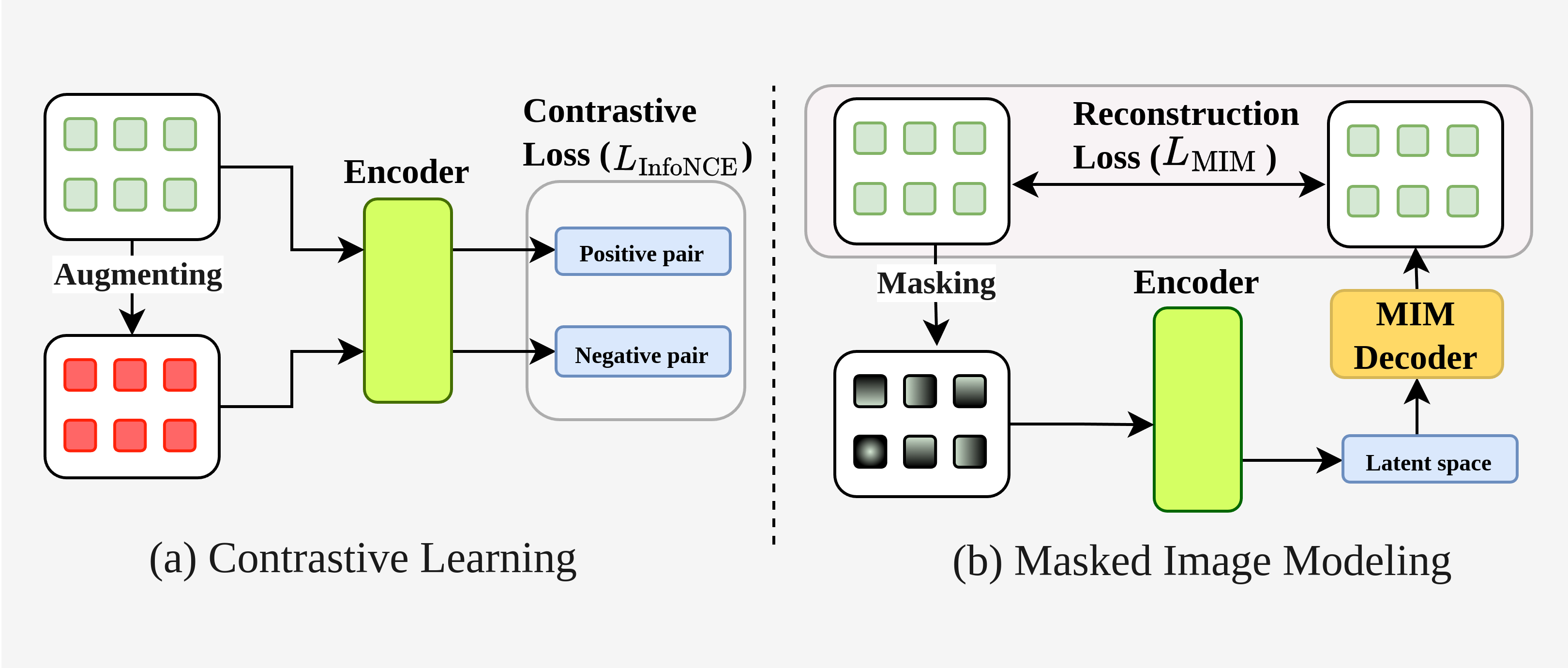
A. Contrastive Objective: The fundamental contrastive objective (shown in Figure 1(a)), commonly expressed as the InfoNCE loss [12], ensures the alignment between positive sample pairs and augmented views of the same image by maximizing the similarity between positive pairs and minimizing it for negative pairs. The loss (Eq. 1) is calculated as:
| (1) |
Here represents the embedding of a query sample, while is its positive counterpart. The negative samples, , are the embeddings of other samples in the batch . The hyperparameter (temperature) controls the separation and smoothness of the learnt representations.
B. MIM Objective: This strategy (shown in Figure 1(b)) entails masking random segments of an input image, requiring the model to reconstruct the missing areas in pixel space. The reconstruction task in MIM is directed by a loss function that assesses the precision of the predicted patches in comparison to their original versions. For a batch of images, the loss function is defined in Eq. 2:
| (2) |
For each image , refers to the masked patches from the input image, while represents the reconstructed versions of those patches. The function models the relationship between the visible and masked regions of the input, with the loss being computed as the negative log-likelihood. This formulation ensures that the reconstruction focuses only on the masked areas, encouraging the model to learn meaningful spatial and contextual patterns from the visible regions.
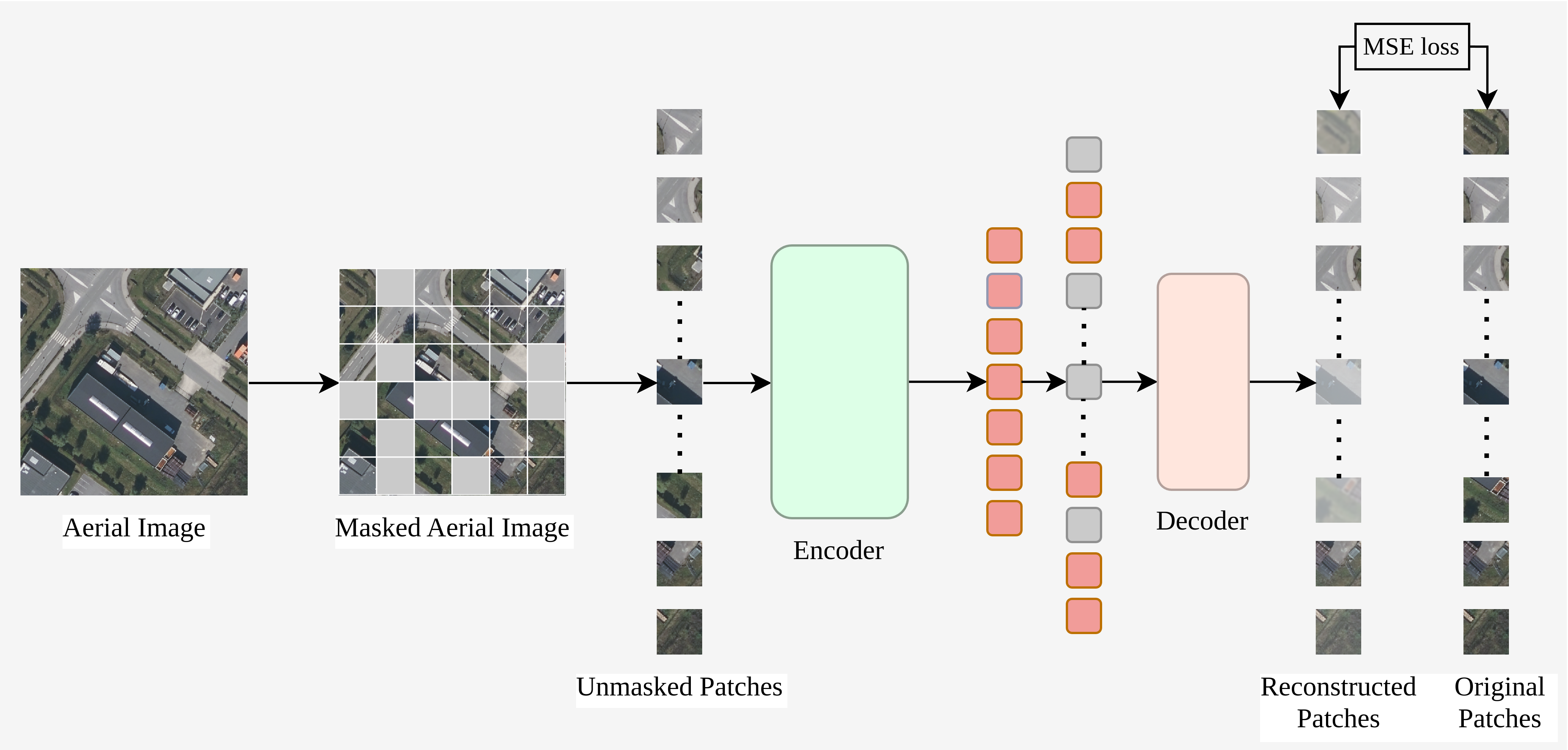
C. MAE [5] Strategy: Figure 2 depicts the architecture of MAE. The input image is divided into a collection of non-overlapping patches . Approximately 75% of these patches are randomly masked. The remaining visible patches, , are then processed by a transformer encoder [17] , which extracts latent features. The encoded features, combined with placeholders representing the masked patches, are fed into the transformer decoder . The decoder’s objective is to reconstruct the pixel values of the original image, ensuring the model accurately captures the spatial and contextual relationships within the input data. The decoder serves just in the pre-training phase, while the encoder is refined for subsequent tasks. The reconstruction is guided by the mean squared error (MSE) loss (Eq. 3), defined as:
| (3) |
where denotes the original masked patches, and represents the reconstructed patches. This loss ensures that the reconstructed output closely approximates the original masked patches, enabling the model to effectively learn spatial and contextual relationships within the image.
2.3 Downstream RS Tasks
The primary application of MAEs in RS is the self-supervised learning of ViTs on a significant amount of pre-trained RS models [20, 19, 34, 27, 21, 40, 26, 41]. SSL4EO-S12 [26] demonstrates the use of standard MAE architecture for scene classification tasks. Similarly, Cha et al. [40] applied masked image modeling techniques, incorporating parallel connections between multi-head self-attention mechanisms and feed-forward layers of ViT [17], to address object detection and semantic segmentation challenges. In the framework CMID [34], contrastive learning is integrated with MIM in a self-distillation manner to achieve a balance between global semantic discrimination and localized spatial awareness, for reconstruction tasks. Scale-MAE [20] redefines the learning objective of the vanilla MAE by reconstructing high-frequency and low-frequency features of remote sensing imagery, employing a ground sample distance-based positional encoding to improve performance. Wang et al. [21] presented a novel method that uses rotational and variable-size window attention to improve object representation learning. In SatMAE [19], temporal embeddings are combined with image masking techniques across time, allowing the model to capture spatio-temporal relationships effectively. Table 1 [28] summarizes the comparison of MAE-based models with contrastive learning-based models across a range of downstream tasks.
3 Summary and Future Scope
This survey emphasizes the transformative potential of MIM frameworks in addressing the unique challenges of remote sensing, such a spectral diversity, and complex spatial relationships. As MIM evolves, future advancements are expected to focus on integrated architectures, such as joint embedding predictive models, which unify generative reconstruction with discriminative feature alignment.
footnotesize
References
- [1] Jia Deng, Wei Dong, Richard Socher, Li-Jia Li, Kai Li, and Li Fei-Fei, “Imagenet: A large-scale hierarchical image database,” in 2009 IEEE conference on computer vision and pattern recognition. Ieee, 2009, pp. 248–255.
- [2] Hangbo Bao, Li Dong, Songhao Piao, and Furu Wei, “Beit: Bert pre-training of image transformers,” arXiv preprint arXiv:2106.08254, 2021.
- [3] Ting Chen, Simon Kornblith, Mohammad Norouzi, and Geoffrey Hinton, “A simple framework for contrastive learning of visual representations,” in International conference on machine learning. PMLR, 2020, pp. 1597–1607.
- [4] Kaiming He, Haoqi Fan, Yuxin Wu, Saining Xie, and Ross Girshick, “Momentum contrast for unsupervised visual representation learning,” in Proceedings of the IEEE/CVF conference on computer vision and pattern recognition, 2020, pp. 9729–9738.
- [5] Kaiming He, Xinlei Chen, Saining Xie, Yanghao Li, Piotr Dollár, and Ross Girshick, “Masked autoencoders are scalable vision learners,” in Proceedings of the IEEE/CVF conference on computer vision and pattern recognition, 2022, pp. 16000–16009.
- [6] Yi Wang, Conrad M Albrecht, Nassim Ait Ali Braham, Lichao Mou, and Xiao Xiang Zhu, “Self-supervised learning in remote sensing: A review,” IEEE Geoscience and Remote Sensing Magazine, vol. 10, no. 4, pp. 213–247, 2022.
- [7] Gordon Christie, Neil Fendley, James Wilson, and Ryan Mukherjee, “Functional map of the world,” in Proceedings of the IEEE Conference on Computer Vision and Pattern Recognition, 2018, pp. 6172–6180.
- [8] Michael Schmitt, Lloyd Haydn Hughes, Chunping Qiu, and Xiao Xiang Zhu, “Sen12ms–a curated dataset of georeferenced multi-spectral sentinel-1/2 imagery for deep learning and data fusion,” arXiv preprint arXiv:1906.07789, 2019.
- [9] Gencer Sumbul, Marcela Charfuelan, Begüm Demir, and Volker Markl, “Bigearthnet: A large-scale benchmark archive for remote sensing image understanding,” in IGARSS 2019-2019 IEEE International Geoscience and Remote Sensing Symposium. IEEE, 2019, pp. 5901–5904.
- [10] Kumar Ayush, Burak Uzkent, Chenlin Meng, Kumar Tanmay, Marshall Burke, David Lobell, and Stefano Ermon, “Geography-aware self-supervised learning,” in Proceedings of the IEEE/CVF International Conference on Computer Vision, 2021, pp. 10181–10190.
- [11] Oscar Manas, Alexandre Lacoste, Xavier Giró-i Nieto, David Vazquez, and Pau Rodriguez, “Seasonal contrast: Unsupervised pre-training from uncurated remote sensing data,” in Proceedings of the IEEE/CVF International Conference on Computer Vision, 2021, pp. 9414–9423.
- [12] Aaron van den Oord, Yazhe Li, and Oriol Vinyals, “Representation learning with contrastive predictive coding,” arXiv preprint arXiv:1807.03748, 2018.
- [13] Peri Akiva, Matthew Purri, and Matthew Leotta, “Self-supervised material and texture representation learning for remote sensing tasks,” in Proceedings of the IEEE/CVF Conference on Computer Vision and Pattern Recognition, 2022, pp. 8203–8215.
- [14] Xin Guo, Jiangwei Lao, Bo Dang, Yingying Zhang, Lei Yu, Lixiang Ru, Liheng Zhong, Ziyuan Huang, Kang Wu, Dingxiang Hu, et al., “Skysense: A multi-modal remote sensing foundation model towards universal interpretation for earth observation imagery,” in Proceedings of the IEEE/CVF Conference on Computer Vision and Pattern Recognition, 2024, pp. 27672–27683.
- [15] Zhenda Xie, Zheng Zhang, Yue Cao, Yutong Lin, Jianmin Bao, Zhuliang Yao, Qi Dai, and Han Hu, “Simmim: A simple framework for masked image modeling,” in Proceedings of the IEEE/CVF conference on computer vision and pattern recognition, 2022, pp. 9653–9663.
- [16] Zhaowen Li, Zhiyang Chen, Fan Yang, Wei Li, Yousong Zhu, Chaoyang Zhao, Rui Deng, Liwei Wu, Rui Zhao, Ming Tang, et al., “Mst: Masked self-supervised transformer for visual representation,” Advances in Neural Information Processing Systems, vol. 34, pp. 13165–13176, 2021.
- [17] Alexey Dosovitskiy, “An image is worth 16x16 words: Transformers for image recognition at scale,” arXiv preprint arXiv:2010.11929, 2020.
- [18] Ze Liu, Yutong Lin, Yue Cao, Han Hu, Yixuan Wei, Zheng Zhang, Stephen Lin, and Baining Guo, “Swin transformer: Hierarchical vision transformer using shifted windows,” in Proceedings of the IEEE/CVF international conference on computer vision, 2021, pp. 10012–10022.
- [19] Yezhen Cong, Samar Khanna, Chenlin Meng, Patrick Liu, Erik Rozi, Yutong He, Marshall Burke, David Lobell, and Stefano Ermon, “Satmae: Pre-training transformers for temporal and multi-spectral satellite imagery,” Advances in Neural Information Processing Systems, vol. 35, pp. 197–211, 2022.
- [20] Colorado J Reed, Ritwik Gupta, Shufan Li, Sarah Brockman, Christopher Funk, Brian Clipp, Kurt Keutzer, Salvatore Candido, Matt Uyttendaele, and Trevor Darrell, “Scale-mae: A scale-aware masked autoencoder for multiscale geospatial representation learning,” in Proceedings of the IEEE/CVF International Conference on Computer Vision, 2023, pp. 4088–4099.
- [21] Di Wang, Qiming Zhang, Yufei Xu, Jing Zhang, Bo Du, Dacheng Tao, and Liangpei Zhang, “Advancing plain vision transformer toward remote sensing foundation model,” IEEE Transactions on Geoscience and Remote Sensing, vol. 61, pp. 1–15, 2022.
- [22] Liya Wang and Alex Tien, “Remote sensing scene classification with masked image modeling (mim),” arXiv preprint arXiv:2302.14256, 2023.
- [23] Yicheng Qiao, Wei Liu, Bin Liang, Pengyun Wang, Haopeng Zhang, and Junli Yang, “Semask-mask2former: A semantic segmentation model for high resolution remote sensing images,” in 2023 IEEE Aerospace Conference. IEEE, 2023, pp. 1–6.
- [24] Zhenghong Li, Hao Chen, Jiangjiang Wu, Jun Li, and Ning Jing, “Segmind: Semi-supervised remote sensing image semantic segmentation with masked image modeling and contrastive learning method,” IEEE Transactions on Geoscience and Remote Sensing, 2023.
- [25] Utkarsh Mall, Bharath Hariharan, and Kavita Bala, “Change-aware sampling and contrastive learning for satellite images,” in Proceedings of the IEEE/CVF Conference on Computer Vision and Pattern Recognition, 2023, pp. 5261–5270.
- [26] Yi Wang, Nassim Ait Ali Braham, Zhitong Xiong, Chenying Liu, Conrad M Albrecht, and Xiao Xiang Zhu, “Ssl4eo-s12: A large-scale multimodal, multitemporal dataset for self-supervised learning in earth observation [software and data sets],” IEEE Geoscience and Remote Sensing Magazine, vol. 11, no. 3, pp. 98–106, 2023.
- [27] Xian Sun, Peijin Wang, Wanxuan Lu, Zicong Zhu, Xiaonan Lu, Qibin He, Junxi Li, Xuee Rong, Zhujun Yang, Hao Chang, et al., “Ringmo: A remote sensing foundation model with masked image modeling,” IEEE Transactions on Geoscience and Remote Sensing, vol. 61, pp. 1–22, 2022.
- [28] Fengxiang Wang, Hongzhen Wang, Di Wang, Zonghao Guo, Zhenyu Zhong, Long Lan, Jing Zhang, Zhiyuan Liu, and Maosong Sun, “Scaling efficient masked autoencoder learning on large remote sensing dataset,” arXiv preprint arXiv:2406.11933, 2024.
- [29] Jacob Devlin, “Bert: Pre-training of deep bidirectional transformers for language understanding,” arXiv preprint arXiv:1810.04805, 2018.
- [30] Gang Li, Heliang Zheng, Daqing Liu, Chaoyue Wang, Bing Su, and Changwen Zheng, “Semmae: Semantic-guided masking for learning masked autoencoders,” Advances in Neural Information Processing Systems, vol. 35, pp. 14290–14302, 2022.
- [31] Jason Tyler Rolfe, “Discrete variational autoencoders,” arXiv preprint arXiv:1609.02200, 2016.
- [32] Letian Fu, Long Lian, Renhao Wang, Baifeng Shi, Xudong Wang, Adam Yala, Trevor Darrell, Alexei A Efros, and Ken Goldberg, “Rethinking patch dependence for masked autoencoders,” arXiv preprint arXiv:2401.14391, 2024.
- [33] Xinye Wanyan, Sachith Seneviratne, Shuchang Shen, and Michael Kirley, “Dino-mc: Self-supervised contrastive learning for remote sensing imagery with multi-sized local crops,” arXiv preprint arXiv:2303.06670, 2023.
- [34] Dilxat Muhtar, Xueliang Zhang, Pengfeng Xiao, Zhenshi Li, and Feng Gu, “Cmid: A unified self-supervised learning framework for remote sensing image understanding,” IEEE Transactions on Geoscience and Remote Sensing, vol. 61, pp. 1–17, 2023.
- [35] Matías Mendieta, Boran Han, Xingjian Shi, Yi Zhu, and Chen Chen, “Towards geospatial foundation models via continual pretraining,” in Proceedings of the IEEE/CVF International Conference on Computer Vision, 2023, pp. 16806–16816.
- [36] Danfeng Hong, Bing Zhang, Xuyang Li, Yuxuan Li, Chenyu Li, Jing Yao, Naoto Yokoya, Hao Li, Pedram Ghamisi, Xiuping Jia, et al., “Spectralgpt: Spectral remote sensing foundation model,” IEEE Transactions on Pattern Analysis and Machine Intelligence, 2024.
- [37] Di Wang, Meiqi Hu, Yao Jin, Yuchun Miao, Jiaqi Yang, Yichu Xu, Xiaolei Qin, Jiaqi Ma, Lingyu Sun, Chenxing Li, et al., “Hypersigma: Hyperspectral intelligence comprehension foundation model,” arXiv preprint arXiv:2406.11519, 2024.
- [38] Boran Han, Shuai Zhang, Xingjian Shi, and Markus Reichstein, “Bridging remote sensors with multisensor geospatial foundation models,” in Proceedings of the IEEE/CVF Conference on Computer Vision and Pattern Recognition, 2024, pp. 27852–27862.
- [39] Vishal Nedungadi, Ankit Kariryaa, Stefan Oehmcke, Serge Belongie, Christian Igel, and Nico Lang, “Mmearth: Exploring multi-modal pretext tasks for geospatial representation learning,” arXiv preprint arXiv:2405.02771, 2024.
- [40] Keumgang Cha, Junghoon Seo, and Taekyung Lee, “A billion-scale foundation model for remote sensing images,” arXiv preprint arXiv:2304.05215, 2023.
- [41] Jonathan Prexl and Michael Schmitt, “Senpa-mae: Sensor parameter aware masked autoencoder for multi-satellite self-supervised pretraining,” arXiv preprint arXiv:2408.11000, 2024.