L2RSI: Cross-view LiDAR-based Place Recognition for Large-scale Urban Scenes via Remote Sensing Imagery This is an extract from a complete paper, so if there existing contextual errors in the content, please ignore them.
Abstract
We tackle the challenge of LiDAR-based place recognition, which traditionally depends on costly and time-consuming prior 3D maps. To overcome this, we first construct XA-L&RSI dataset, which encompasses approximately remote sensing submaps and LiDAR point cloud submaps captured in urban scenes, and propose a novel method, L2RSI, for cross-view LiDAR place recognition using high-resolution Remote Sensing Imagery. This approach enables large-scale localization capabilities at a reduced cost by leveraging readily available overhead images as map proxies. L2RSI addresses the dual challenges of cross-view and cross-modal place recognition by learning feature alignment between point cloud submaps and remote sensing submaps in the semantic domain. Additionally, we introduce a novel probability propagation method based on a dynamic Gaussian mixture model to refine position predictions, effectively leveraging temporal and spatial information. This approach enables large-scale retrieval and cross-scene generalization without fine-tuning. Extensive experiments on XA-L&RSI demonstrate that, within a retrieval range, L2RSI accurately localizes of point cloud submaps within a radius for top- retrieved location. We provide a video to more vividly display the place recognition results of L2RSI at https://shizw695.github.io/L2RSI/.
![[Uncaptioned image]](/html/2503.11245/assets/introduction_arxiv.jpg)
1 Introduction
Place recognition aims to retrieve the closest match and its location from a pre-built database within the global coordinate system, serving as an essential task for autonomous driving and robotic navigation. LiDAR-based place recognition is now increasingly attractive since 3D point clouds from LiDAR are invariant to lighting and shadows [11].
Existing LiDAR-based place recognition methods face a significant limitation: they depend on up-to-date prior 3D maps, the acquisition and maintenance of which are time-consuming and costly. Recent research has sought to address this issue by exploring alternative approaches. Tang et al. [8, 9] unified overhead imagery and LiDAR into a pseudo point cloud modality, achieving retrieval-based place recognition. However, their approach only works on the assumption of a known route, which confines the retrieval process to a very limited range. Cho et al. [2] conducted LiDAR-based place recognition using OpenStreetMap (OSM). Due to the dual challenges of cross-view and cross-modality, existing methods typically restrict the retrieval area to a small range. The most commonly used 3D datasets include the Oxford Radar RobotCar [1], KITTI [4], and KITTI-360 [12]. The former consists of multiple repeated trajectories, covering an area of less than , while the latter two datasets are composed of several independent trajectories, with the largest covering range approximately .
This work presents a solution for LiDAR-based place recognition (LPR) in large-scale (over ) urban scenes without prior 3D maps. As shown in Fig. 1, we utilize high-resolution remote sensing imagery as the database due to its global coverage, cost-effectiveness, and timeliness. The challenges in cross-view and cross-modal are placed under the spotlight. We observe that the content and style between LiDAR point clouds and remote sensing imagery, even from the same location, can differ significantly. However, they exhibit strong correlations in the semantic domain, as illustrated in the bottom-left corner of Fig. 1. Inspired by this observation, we design a semantic contrastive learning network to align the global descriptors of LiDAR point cloud submaps and remote sensing submaps in the semantic space. In addition, we propose a probabilistic propagation algorithm based on a dynamic Gaussian Mixture Model (DGMM-ProP) to address the unreliability of retrieval results for a single query. Crucially, this propagation mechanism eliminates the ambiguity between geometrically distant but semantically similar positions.
The contributions of this work are summarized as follows:
-
•
To the best of our knowledge, the proposed method addresses for the first time the challenge of large-scale (over ) urban cross-view LiDAR-based place recognition with high-resolution remote sensing imagery, demonstrating promising performance with significant practical applicability.
-
•
We provide a retrieval-based network for cross-view and cross-modal LiDAR-based place recognition, that learns to align LiDAR point clouds with remote sensing imagery in semantic space, given the available absolute orientation.
-
•
We propose a probabilistic propagation algorithm that utilizes a dynamic Gaussian Mixture Model to propagate spatio-temporal information and infer the probability density of the current position, significantly improving the retrieval performance.
-
•
The proposed method exhibits remarkable generalization ability, achieves () of within a retrieval range of , and demonstrates robust performance on cross scene generalization without fine-tuning.
2 Problem statement
We begin by defining the large-scale remote sensing imagery to be a collection of square submaps . Each submap is sampled at equal intervals with partial overlap and includes the UTM coordinates of the center point. Let be a query point cloud submap obtained by aggregating a short sequence of LiDAR scans. Our task is defined as determining the coarse position of the center point in the query point cloud submap, which is a cross-view, cross-modal retrieval problem:
| (1) |
where and denote the deep learning networks used to encode the point cloud submap and remote sensing submaps into a shared feature space. represents a measure of similarity, e.g., the dot product. represents the absolute orientation of the intermediate frame in . We assume that is known and is obtained through GPS/INS.
3 Methodology
Fig. LABEL: shows the overview of the proposed L2RSI. We will introduce the Data preprocessing module in Sec. LABEL:. Sec. LABEL: givess the approach to train the global descriptor extractor for the query point cloud submaps and the remote sensing submaps. Sec. LABEL: introduces DGMM-ProP, which aims to estimate the probability density of the current query position and refine these candidates.
4 Experiment
4.1 Benchmark dataset
Due to the lack of publicly available datasets that provide correspondences between large-scale outdoor LiDAR scans and remote sensing imagery, we construct the XA-L&RSI and Oxford-L&RSI datasets for training and evaluation.
XA-L&RSI. We purchase high-resolution remote sensing imagery covering Xiang’an District from AIRSAT Technology Group. We extract submaps from the original remote sensing imagery.
We utilize a Ouster OS1-64 LiDAR to acquire point cloud data in the Xiang’an District of Xiamen. Ground truth and simulated orientation information were obtained through GPS/INS.
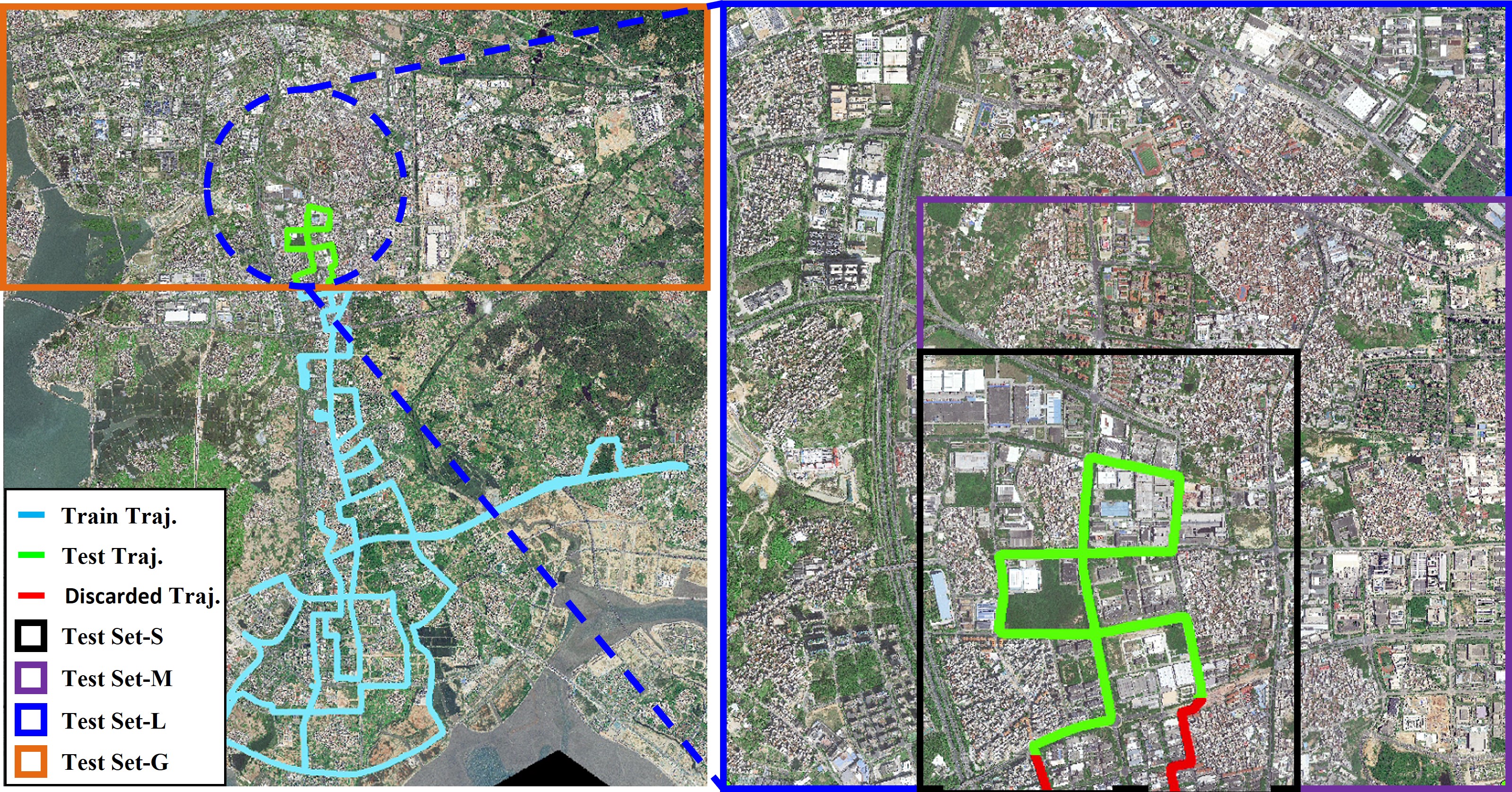
The vehicle trajectory is shown in Fig. 2(a). We select the green trajectory as the test set, with the remaining portion used for training. For the training set, we manually exclude data with inherent misalignment between ground and aerial semantic information to avoid confusion during training. This includes elevated highways, road segments completely obstructed by street trees, and roadwork zones. For the test set, we established databases of (S), (M), (L) and (G) to evaluate the retrieval performance of the proposed method, see Table 1. Notably, the point cloud at the boundary between the test and training sets are discarded, ensuring that the network is never exposed to the test set data during training.
| XA-L&RSI | Submap number | Area () | |
| PC | RSI | ||
| Training Set | 12194 | 47913 | 65 |
| Test Set-S | 862 | 3094 | 4 |
| Test Set-M | 862 | 6479 | 9 |
| Test Set-L | 862 | 12119 | 16 |
| Test Set-G | 862 | 63047 | 100 |
| Oxford-L&RSI | Submap number | Area () | |
| PC | RSI | ||
| 11-14-02-26 | 1697 | 2103 | 2.8 |
| 14-12-05-52 | 1671 | 2103 | 2.8 |
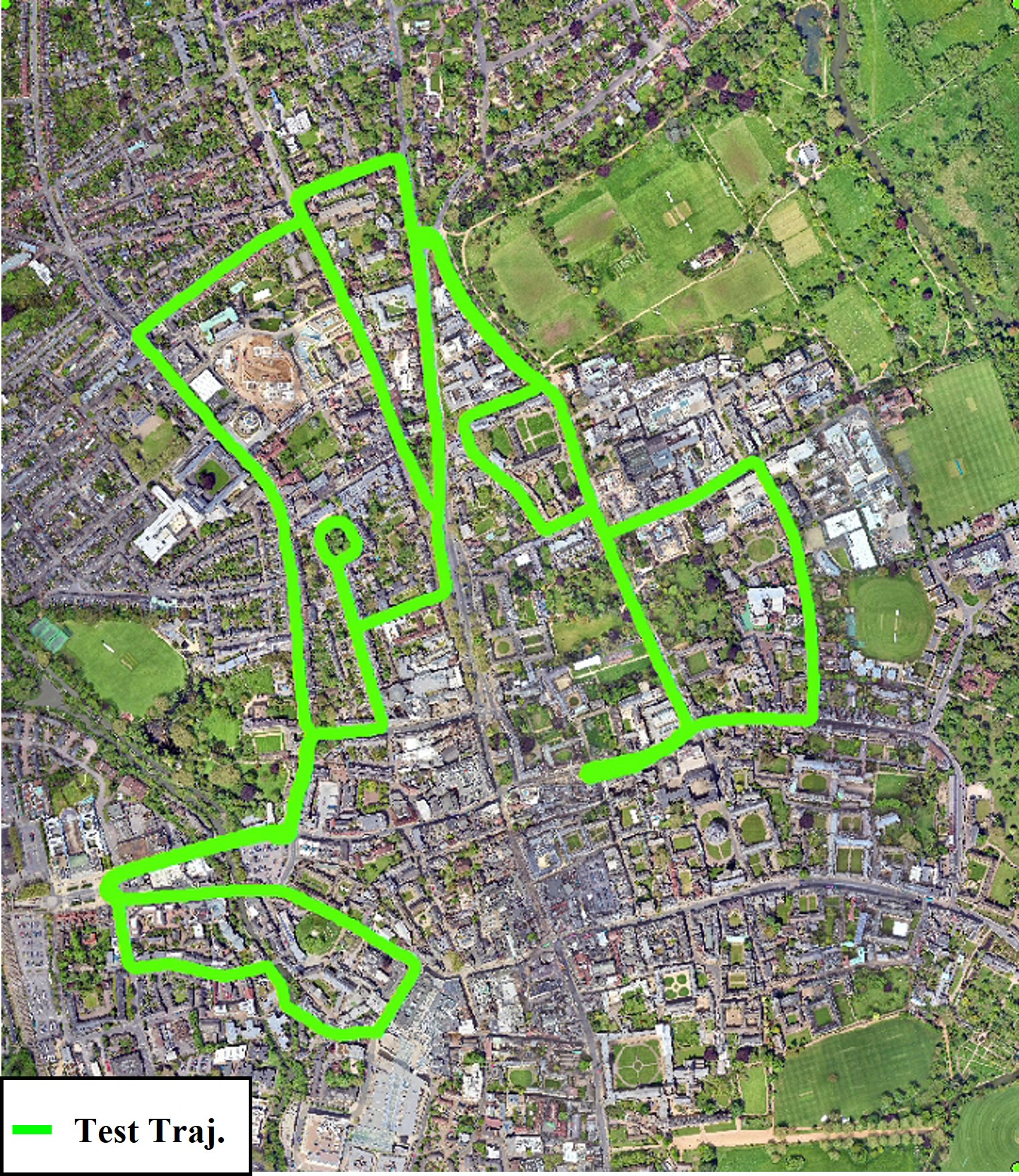
Oxford-L&RSI. Oxford Radar RobotCar is a famous urban scene dataset [1] for localization. The data is collected with a Velodyne HDL-32E LiDAR. The dataset includes multiple repeated traversals, each covering about , as shown in Fig. 2(b). Based on this, we supplement the database with the corresponding remote sensing imagery, covering an area of approximately . The source and resolution of remote sensing imagery, as well as the data preprocessing process, are the same as those of the XA-L&RSI. The data of 11-14-02-26, 14-12-05-52 are used as the test set to evaluate the generalization ability of the proposed method without fine-tuning, see Table 1.
4.2 Evaluation criteria
Following pervious place recognition task [10, 6], we use retrieval recall to evaluate LiDAR-based place recognition based on remote sensing imagery. means the recall at top- retrieval results, that is, the proportion of queries for which the correct result is retrieved within the top- results. We define a correct result as when the Euclidean distance between the center of the retrieved remote sensing submap and the center of the query point cloud submap is less than . We particularly emphasize on , as it has the most direct practical relevance.
4.3 Implementation details
The proposed L2RSI is implemented with Pytorch [7]. The network is trained with Adam optimizer [5]. All experiments are performed on Ubuntu with a single NVIDIA GTX GPUs.
| XA-L&RSI | / () | |||
| GeoDTR [14] | Sample4Geo [3] | FRGeo [13] | Ours | |
| Test Set-S | 11.72/28.56 | 40.95/65.55 | 29.81/56.15 | 99.02/99.88 |
| Test Set-M | 8.47/23.55 | 37.35/62.65 | 25.29/48.26 | 97.42/98.89 |
| Test Set-L | 5.54/18.68 | 35.15/59.29 | 20.77/42.34 | 96.56/98.65 |
| Test Set-G | 3.60/10.79 | 32.37/56.96 | 18.79/37.94 | 95.08/97.42 |
| Oxford-L&RSI | / () | |||
| GeoDTR [14] | Sample4Geo [3] | FRGeo [13] | Ours | |
| 11-14-02-26 | 0.47/2.77 | 9.90/23.75 | 2.06/4.54 | 68.75/83.19 |
| 14-12-05-52 | 0.48/2.81 | 10.29/25.01 | 1.92/5.21 | 69.05/81.07 |
4.4 Results
4.4.1 Evaluation on test sets
The proposed L2RSI is the first to perform cross-view LiDAR-based place recognition in large-scale urban scenes with high-resolution remote sensing imagery. Several state-of-the-art cross-view image retrieval networks are capable of handling preprocessed cross-modal semantic images,e.g. GeoDTR [14], Sample4Geo [3] and FRGeo [13]. Firstly, we benchmark them to evaluate the performance of our method in the test sets of XA-L&RSI with different size databases. The training settings on XA-L&RSI for all methods are consistent, except for the image size and descriptor dimensions, which follow the official configurations. The comparison is summarized in the upper part of Table 2. L2RSI significantly outperforms the baseline methods, reaches a of with a database of . As the retrieval range expands, L2RSI demonstrates increased robustness, with the database area increased to and only a degradation in and a degradation in .
Secondly, we directly test the model on the Oxford-L&RSI without any fine-tuning. Given the stark differences in road widths, architectural styles, and other factors across cities or even countries, this challenge marks the the highest level of generalization ability. In the lower part of Table 2, the baseline methods fail completely, while L2RSI achieves close to and above on both trajectories. Although the current results are not yet sufficient for real-world deployment, they demonstrate great potential for future applications.
5 Conclusion
We presented L2RSI, the first method for cross-view LiDAR-based place recognition within large-scale (over ) urban scenes using high-resolution remote sensing imagery. We unify LiDAR point cloud submaps and remote sensing submaps into a shared semantic space via a carefully-designed contrastive learning network. Furthermore, we construct a dynamic Gaussian mixture model to encapsulate the spatio-temporal constraints of sequential queries, thereby further refining the performance of global place recognition. Extensive experiments on the XA-L&RSI and Oxford-L&RSI datasets demonstrate the effectiveness and generalization ability of L2RSI. Future work will further address the challenges of deploying this technology in real-world applications.
References
- Barnes et al. [2020] Dan Barnes, Matthew Gadd, Paul Murcutt, Paul Newman, and Ingmar Posner. The oxford radar robotcar dataset: A radar extension to the oxford robotcar dataset. In 2020 IEEE international conference on robotics and automation (ICRA), pages 6433–6438. IEEE, 2020.
- Cho et al. [2022] Younghun Cho, Giseop Kim, Sangmin Lee, and Jee-Hwan Ryu. Openstreetmap-based lidar global localization in urban environment without a prior lidar map. IEEE Robotics and Automation Letters, 7(2):4999–5006, 2022.
- Deuser et al. [2023] Fabian Deuser, Konrad Habel, and Norbert Oswald. Sample4geo: Hard negative sampling for cross-view geo-localisation. In Proceedings of the IEEE/CVF International Conference on Computer Vision, pages 16847–16856, 2023.
- Geiger et al. [2013] Andreas Geiger, Philip Lenz, Christoph Stiller, and Raquel Urtasun. Vision meets robotics: The kitti dataset. The international journal of robotics research, 32(11):1231–1237, 2013.
- Kingma [2014] Diederik P Kingma. Adam: A method for stochastic optimization. arXiv preprint arXiv:1412.6980, 2014.
- Lee et al. [2023] Alex Junho Lee, Seungwon Song, Hyungtae Lim, Woojoo Lee, and Hyun Myung. (LC)2 : Lidar-camera loop constraints for cross-modal place recognition. IEEE Robotics and Automation Letters, 8(6):3589–3596, 2023.
- Paszke et al. [2019] Adam Paszke, Sam Gross, Francisco Massa, Adam Lerer, James Bradbury, Gregory Chanan, Trevor Killeen, Zeming Lin, Natalia Gimelshein, Luca Antiga, et al. Pytorch: An imperative style, high-performance deep learning library. Advances in neural information processing systems, 32, 2019.
- Tang et al. [2023a] Tim Yuqing Tang, Daniele De Martini, and Paul Newman. Point-based metric and topological localisation between lidar and overhead imagery. Autonomous Robots, 47(5):595–615, 2023a.
- Tang et al. [2023b] Tim Y Tang, Daniele De Martini, and Paul M Newman. Self-supervised lidar place recognition in overhead imagery using unpaired data. Proceedings of Robotics: Science and Systems, 2023b.
- Uy and Lee [2018] Mikaela Angelina Uy and Gim Hee Lee. Pointnetvlad: Deep point cloud based retrieval for large-scale place recognition. In Proceedings of the IEEE conference on computer vision and pattern recognition, pages 4470–4479, 2018.
- Xia et al. [2021] Yan Xia, Yusheng Xu, Shuang Li, Rui Wang, Juan Du, Daniel Cremers, and Uwe Stilla. Soe-net: A self-attention and orientation encoding network for point cloud based place recognition. In Proceedings of the IEEE/CVF Conference on computer vision and pattern recognition, pages 11348–11357, 2021.
- Xie et al. [2016] Jun Xie, Martin Kiefel, Ming-Ting Sun, and Andreas Geiger. Semantic instance annotation of street scenes by 3d to 2d label transfer. In Proceedings of the IEEE conference on Computer Vision and Pattern Recognition, pages 3688–3697, 2016.
- Zhang and Zhu [2024] Qingwang Zhang and Yingying Zhu. Aligning geometric spatial layout in cross-view geo-localization via feature recombination. In Proceedings of the AAAI Conference on Artificial Intelligence, pages 7251–7259, 2024.
- Zhang et al. [2023] Xiaohan Zhang, Xingyu Li, Waqas Sultani, Yi Zhou, and Safwan Wshah. Cross-view geo-localization via learning disentangled geometric layout correspondence. In Proceedings of the AAAI Conference on Artificial Intelligence, pages 3480–3488, 2023.