2023 \startpage1
VEGO et al. \titlemarkTHE SAND ATLAS
Corresponding author Benjy Marks, School of Civil Engineering, The University of Sydney, NSW, Australia, 2006
The Sand Atlas
Abstract
[Abstract]The Sand Atlas is a publicly accessible repository dedicated to the collection, processing, and sharing of high-resolution 3D models of sand-sized particles. This dataset offers valuable insights into the morphology of a wide variety of natural and synthetic sand-sized particles from different regions, with varying mineralogy and history. The primary goal of The Sand Atlas is to support researchers, educators, and industry professionals by providing detailed, easily accessible and uniformly produced surface meshes and level-set data. The underlying code that converts volumetric data to meshes is also available via the sand-atlas python package. This platform encourages community participation, inviting contributors to share their own data and enrich the collective understanding of granular materials.
keywords:
Granular material, Particle, Sand, Shape1 Introduction
Understanding the morphology and properties of sand-sized particles is essential in fields such as geotechnical engineering, sedimentology, and material science. The shape, size, and surface characteristics of sand-sized particles significantly influence the mechanical and flow behaviour of granular assemblies, affecting properties like strength, stiffness, and permeability 14, 6, 5. Despite their importance, obtaining detailed morphological data of individual particles has been challenging due to limitations in imaging and processing technologies 2.
The Sand Atlas (sand-atlas.scigem.com) addresses this gap by collating a comprehensive dataset of sand-sized grains, with detailed 3D surface meshes generated from micro-computed tomography (micro-CT) scans. Micro-CT scanning allows for non-destructive, high-resolution imaging of the internal and external structures of particles 10. Each dataset in The Sand Atlas is available at voxel-scale accuracy, as well as four standardised resolutions, enabling researchers to explore and download models in varying quality suitable for different applications.
This project is a collaborative effort between international researchers specialising in granular materials. The platform is designed to be a community-driven resource, encouraging contributions from the global scientific community. By providing open access to high-quality morphological data, The Sand Atlas aims to facilitate advancements in research areas such as particle shape analysis 18, discrete element method (DEM) simulations 9, and soil mechanics 1.
| Sample Name | Type of Particle | Number of Particles | Voxel Size (µm) | Source publication |
|---|---|---|---|---|
| Couscous | Edible grain | 81 | 2.8 | 17 |
| Hamburg sand | Quartz quarry sand | 8088 | 11 | 12 |
| Hostun sand | Angular quartz sand | 86 | 1 | 19 |
| Operculina ammonoides | Foraminifera species | 46 | 15 | 11 |
| Ottawa sand 7.3µm | Natural silica sand | 3367 | 7.3 | |
| Ottawa sand 1µm | Natural silica sand | 244 | 1 | |
| LECA | Expanded clay | 598 | 10.75 | 7 |
| Caicos Ooids | Calcitic ooids | 117 | 1 | |
| Coffee | Edible grain | 1 | 0.8 |
The data processing pipeline uses the open source tools numpy 8, scikit-image 16, spam 15, Blender 4 and OpenVDB 13, which ensure high-quality and reproducible data outputs. numpy is a python package for maniuplating arrays. scikit-image and spam are collections of algorithms for image processing. Blender is a 3D modelling program with advanced mesh operations. OpenVDB is an C++ library comprising a novel data structure and tools for the efficient storage and manipulation of sparse volumetric data. The underlying code that converts volumetric data to meshes is also available via the sand-atlas python package, promoting transparency and enabling users to process their own datasets according to their needs.
The 3D models available on the platform represent a wide range of particles, including geological samples such as Ottawa sand, which is a standardised testing sand in geotechnical engineering 3, and industrial materials such as Hostun sand, known for its angular grains 19. By encompassing a variety of particle types with different origins and properties, The Sand Atlas aims to provide a valuable resource for comparative studies and modelling efforts.
The broader goal of The Sand Atlas is to support the advancement of knowledge in the field of granular materials by providing a repository of high-resolution particle data. This data set has significant reuse potential, enabling applications in numerical simulations, educational tools, and the development of new analytical and statistical methods for particle characterisation.
2 Data Description and Development
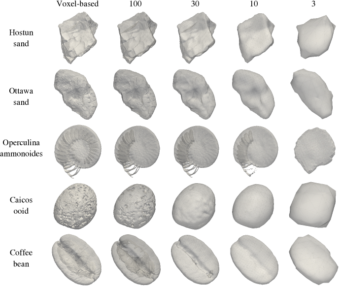
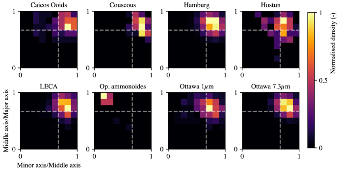
A snapshot of the available data is shown in Table 1, encompassing 12,628 unique particles from nine different data sources. Examples of the rendered meshes of some of these particles are shown in Figure 1 in various mesh qualities, each of which is available to download. Statistical measures of the shapes of the particles have also been computed for each particle, and representative measures for most samples are shown in Figure 2.
2.1 Data pipeline
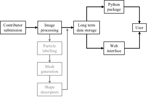
As outlined in Figure 3, the creation of The Sand Atlas dataset involves several key steps: sample collection, image processing, mesh generation, video rendering, and data dissemination. The first two steps are performed by contributors prior to uploading their data to the database, although the second step may be reproduced by The Sand Atlas Editorial team if the submitted data does not meet the quality thresholds.
-
1.
Contributor submission: Samples are submitted to the repository of particles from various natural and industrial sources, ensuring a diverse representation of particle types. Each sample is carefully documented with information – when available – on its origin, mineralogy, and any relevant geological or industrial processing history. Typically the source data has been uploaded to another data repository, and already has been assigned a DOI.
-
2.
Image Processing and Segmentation: The raw micro-CT data is processed to enhance image quality and segment individual particles. Noise reduction filters and thresholding techniques are applied to separate particles from the background. The segmentation process isolates each particle, creating labelled datasets for further analysis.
-
3.
Mesh Generation: Surface meshes are generated from labelled volumetric data using OpenVDB, allowing for efficient storage and manipulation of the sparse volumetric data, facilitating the conversion to high-quality surface meshes. The meshes are produced at five levels of resolution to accommodate different research needs.
-
4.
Video generation: Blender is used to render videos of each particle, so that a user can visualise and inspect the particles and the mesh quality on The Sand Atlas website before downloading.
-
5.
Shape Descriptor Calculation: Shape descriptors such as sphericity, roundness, and aspect ratio are calculated using spam 15. These quantitative measures provide valuable information about the morphological characteristics of each particle.
-
6.
Data Dissemination: The processed data, including volumetric data (VDB files), surface meshes (STL files), and calculated shape descriptors, are uploaded to The Sand Atlas platform. Metadata accompanying each dataset includes information about the sample origin, scanning parameters, and processing techniques.
2.2 Technical Validation
To ensure the reliability and accuracy of the dataset, several validation steps were performed. Upon submission, micro-CT images are inspected for artefacts, noise levels, and resolution adequacy. The segmentation results are validated by comparing the segmented particles with the original images to ensure accurate boundary detection. Over- and under-segmentation issues are resolved using the algorithms proposed and implemented in spam 15. If necessary, the images are relabelled by The Sand Atlas team. Meshes are refined or regenerated if any issues are detected. The calculated shape descriptors are cross-validated with known standards or reference measurements where available.
3 Dataset Access
The Sand Atlas hosts multiple datasets, each corresponding to a different type of sample. These datasets are stored on the Research Data Store infrastructure provided by The University of Sydney and are accessible through The Sand Atlas website or python package. Each dataset is given a Unique Resource Identifier (URI) when first added to the repository. Each dataset includes:
-
1.
Volumetric Data: The original raw micro-CT image and the corresponding labelled image are stored as TIFF files.
-
2.
Level Set Representation: VDB files containing the level set representations of the particles.
-
3.
Surface Meshes: STL files of the particles at varying mesh resolutions.
-
4.
Shape Descriptors: CSV files containing calculated shape parameters for each particle (e.g., volume, equivalent diameter, axes lengths).
-
5.
Metadata: Documentation of the sample origin, scanning parameters, and processing methods.
For example, the Ottawa 7.3µm sand dataset contains 3,367 individual particles with mesh resolutions ranging from 1 facet per voxel to 100, 30, 10 and 3 facets across the shortest axis. Users have the flexibility to adjust the resolution and file formats to meet their research requirements by directly modifying the open-source code. These datasets can be used for applications such as DEM simulations, morphological analysis, and educational purposes.
4 Potential Dataset Use and Reuse
Each dataset in The Sand Atlas is freely available under a Creative Commons Attribution license, allowing users to share and adapt the material provided appropriate credit is given. Researchers can access and download the raw (i.e., directly provided by the contributor) and processed data directly from The Sand Atlas website. Users can also download the data using the sand-atlas python package.
To use the datasets:
-
•
Visualization: The STL mesh files can be viewed using standard 3D visualisation software such as MeshLab and Paraview.
-
•
Simulation: The mesh and volumetric data can be imported into simulation software for DEM or finite element analyses.
-
•
Analysis: Shape descriptors can be used for statistical analysis or to correlate particle morphology with material properties.
Contributors are encouraged to submit their own data through the submission process outlined on the website. The platform supports visual exploration, allowing users to manipulate 3D models directly on the website.
The Sand Atlas repository is expected to expand over time as new datasets are added. Future updates may include additional sand samples and granular materials contributed by the research community or generated through laboratory studies. These efforts aim to further enhance the diversity and applicability of the repository across various scientific disciplines, including but not limited to geoscience and geomechanics.
4.1 Code availability
Two separate code sources are available. Firstly, the code used to generate the website itself is available at https://github.com/scigem/sand-atlas/. This includes the search functionality and the interactive elements.
The code used to process the micro-CT data and generate the meshes is available as the sand-atlas python package. The source code for this package is stored on GitHub at https://github.com/scigem/sand-atlas-python/. This package includes scripts for image processing, segmentation, mesh generation, and calculation of shape descriptors. Specific variables and parameters used in the processing pipeline are documented within the code repository, along with examples and instructions for reproducing the datasets.
4.2 Data availability
All data stored in The Sand Atlas is freely available under a Creative Commons licence. Data can be downloaded directly from https://sand-atlas.scigem.com or via the sand-atlas python package.
References
- Altuhafi et al. 2016 Altuhafi, F.N., Coop, M.R. & Georgiannou, V.N. (2016) Effect of particle shape on the mechanical behavior of natural sands. Journal of Geotechnical and Geoenvironmental Engineering, 142(12), 04016071. doi:10.1061/(ASCE)GT.1943-5606.0001569.
- Andò et al. 2022 Andò, E., Marks, B., Hurley, R. & Dijksman., J.A. (2022) Advanced Experimental Geomechanics. : ALERT Geomaterials.
- ASTM International 2021 ASTM International (2021) Standard Specification for Standard Sand (C778). https://doi.org/10.1520/C0778-21, aSTM International, West Conshohocken, PA.
-
Community 2018
Community, B.O. (2018) Blender - a 3D modelling and rendering package. Blender Foundation, Stichting Blender Foundation, Amsterdam.
URL http://www.blender.org -
Fan et al. 2024
Fan, B., Pongó, T., Cruz Hidalgo, R. & Börzsönyi, T. (2024) Effect of particle shape on the flow of an hourglass. Phys. Rev. Lett., 133, 058201. doi:10.1103/PhysRevLett.133.058201.
URL https://link.aps.org/doi/10.1103/PhysRevLett.133.058201 - Fonseca et al. 2012 Fonseca, J., O’Sullivan, C., Coop, M.R. & Lee, P. (2012) Non-invasive characterization of particle morphology of natural sands. Soils and Foundations, 52(4), 712–722.
- Guida et al. 2018 Guida, G., Casini, F., Viggiani, G.M.B., Andò, E. & Viggiani, G. (2018) Breakage mechanisms of highly porous particles in 1d compression revealed by x-ray tomography. Géotechnique Letters, 8(2), 155–160. doi:10.1680/jgele.18.00035.
-
Harris et al. 2020
Harris, C.R., Millman, K.J., van der Walt, S.J., Gommers, R., Virtanen, P., Cournapeau, D. et al. (2020) Array programming with NumPy. Nature, 585(7825), 357–362. doi:10.1038/s41586-020-2649-2.
URL https://doi.org/10.1038/s41586-020-2649-2 - Kawamoto et al. 2018 Kawamoto, R., Andò, E., Viggiani, G. & Andrade, J.E. (2018) All you need is shape: Predicting shear banding in sand with ls-dem. Journal of the Mechanics and Physics of Solids, 111, 375–392.
- Ketcham and Carlson 2001 Ketcham, R.A. & Carlson, W.D. (2001) Acquisition, optimization and interpretation of x-ray computed tomographic imagery: applications to the geosciences. Computers & Geosciences, 27(4), 381–400.
- Luijmes et al. 2024 Luijmes, J., van Leeuwen, T. & Renema, W. (2024) Forametcetera, a novel ct scan dataset to expedite classification research of (non-) foraminifera. Scientific Data, 11(1), 642.
- Milatz et al. 2021 Milatz, M., Hüsener, N., Andò, E., Viggiani, G. & Grabe, J. (2021) Quantitative 3d imaging of partially saturated granular materials under uniaxial compression. Acta geotechnica, 16(11), 3573–3600.
- Museth 2013 Museth, K. (2013) Vdb: High-resolution sparse volumes with dynamic topology. ACM transactions on graphics (TOG), 32(3), 1–22.
- Santamarina et al. 2001 Santamarina, J.C., Klein, A. & Fam, M.A. (2001) Soils and waves: Particulate materials behavior, characterization and process monitoring. Journal of Soils and Sediments, 1(2), 130–130.
- Stamati et al. 2020 Stamati, O., Andò, E., Roubin, E., Cailletaud, R., Wiebicke, M., Pinzon, G. et al. (2020) spam: Software for Practical Analysis of Materials. Journal of Open Source Software, 5(51), 2286. doi:10.21105/joss.02286.
-
van der Walt et al. 2014
van der Walt, S., Schönberger, J.L., Nunez-Iglesias, J., Boulogne, F., Warner, J.D., Yager, N. et al. (2014) scikit-image: image processing in Python. PeerJ, 2, e453. doi:10.7717/peerj.453.
URL https://doi.org/10.7717/peerj.453 -
Vego 2023
Vego, I. (2023) Multi-modal investigation of hygroscopic granular media at high relative humidity. Ph.D. thesis, Université Grenoble Alpes.
URL https://theses.hal.science/tel-04360890 - Vlahinić et al. 2014 Vlahinić, I., Andò, E., Viggiani, G. & Andrade, J.E. (2014) Towards a more accurate characterization of granular media: extracting quantitative descriptors from tomographic images. Granular Matter, 16(1), 9–21.
-
Wiebicke et al. 2017
Wiebicke, M., Andò, E., Herle, I. & Viggiani, G. (2017) On the metrology of interparticle contacts in sand from x-ray tomography images. Measurement Science and Technology, 28(12), 124007. doi:10.1088/1361-6501/aa8dbf.
URL https://dx.doi.org/10.1088/1361-6501/aa8dbf - Zingg 1935 Zingg, T. (1935) Beitrag zur schotteranalyse. Ph.D. thesis, ETH Zurich.
Acknowledgements
The authors thank the contributing researchers and the development team for their ongoing efforts in maintaining and expanding The Sand Atlas. Special recognition goes to the core steering committee for their leadership in this project. The authors would also like to thank the organisers of the “Getting into Shape” Lorentz Centre Workshop where this idea was discussed and significantly progressed.
Author contributions statement
B.M. conceived of and designed the project. B.M. developed the data processing pipeline and The Sand Atlas platform. I.V. performed the data processing. Both authors analysed the results and reviewed the manuscript.
Conflicts of interest
The authors declare no conflict of interest.