Large-scale Remote Sensing Image Target Recognition and Automatic Annotation
Abstract
This paper presents a method for object recognition and automatic labeling in large-area remote sensing images called LRSAA. The method integrates YOLOv11 and MobileNetV3-SSD object detection algorithms through ensemble learning to enhance model performance. Furthermore, it employs Poisson disk sampling segmentation techniques and the EIOU metric to optimize the training and inference processes of segmented images, followed by the integration of results. This approach not only reduces the demand for computational resources but also achieves a good balance between accuracy and speed. The source code for this project has been made publicly available on https://github.com/anaerovane/LRSAA.
Index Terms:
remote sensing, target recognition, machine learning, automatic annotation, poisson diskI Introduction
Remote sensing target recognition technology refers to the technique of utilizing image data acquired from satellites or aircraft, and through computer processing and analysis, achieving automatic detection and classification of specific targets on the ground. This technology plays a crucial role in environmental protection, resource management, disaster monitoring, and national defense security, providing timely and accurate information support for decision-making. With the application of deep learning-based target recognition methods, the accuracy and efficiency of remote sensing target recognition have been significantly improved, making it possible to detect small targets and recognize targets under complex backgrounds, thus further expanding its application scope.
Nonetheless, remote sensing object recognition technology still faces several challenges and holds potential for further optimization. First, since the inception of object recognition algorithms, this field has undergone significant technological evolution and developmental phases. Recent advancements have primarily centered around Google’s MobileNetV3-SSD and Ultralytics’ YOLOv11 models, which have notably enhanced the accuracy and computational efficiency of object detection. Despite the widespread application of earlier object recognition methods in remote sensing image analysis, the adoption of the latest generation models, such as YOLOv11 and MobileNetV3-SSD, remains relatively limited. Furthermore, current remote sensing object recognition technologies predominantly rely on single-model training and prediction, a strategy that simplifies the prediction architecture and reduces computational costs but may also compromise the model’s generalization ability and robustness. At present, there is a lack of an effective framework to integrate the outputs from various remote sensing algorithms, which could lead to improved recognition performance. Lastly, most existing remote sensing object recognition schemes are designed for object identification and inference tasks on small-scale remote sensing images, exhibiting deficiencies in recognition accuracy and excessive demands on computational resources when applied to large-scale images. This limitation hinders their applicability in automated annotation systems for large-scale remote sensing imagery.
To address these challenges, we propose an innovative framework aimed at improving the performance of object recognition and automatic labeling in large-scale remote sensing images. This framework not only addresses the applicability and efficiency issues of existing technologies on large datasets but also seeks to minimize hardware resource dependencies through optimized algorithm design, thereby facilitating broader practical applications. Our approach introduces several key technical innovations:
-
•
Ensemble Learning with MobileNetV3-SSD and YOLOv11: We integrate the MobileNetV3-SSD and YOLOv11 models to leverage ensemble learning, combining the strengths of both architectures to achieve superior performance.
-
•
Enhanced Non-Maximum Suppression (NMS) via EIOU Metric: We substitute the conventional Intersection over Union (IoU) metric with the Enhanced IoU (EIOU) metric for NMS, which improves the suppression process by considering additional geometric information.
-
•
Poisson Disk Sampling for Dataset Partitioning and Recognition: Utilizing Poisson disk sampling techniques, we effectively partition and recognize training and application datasets, ensuring a balanced distribution of samples and enhancing the representativeness of the data.
Through these technological advancements, we have trained and evaluated the Large-Scale Remote Sensing Automatic Annotation (LRSAA) model using the XView dataset. Subsequently, the model was applied to remote sensing images of Tianjin for automatic annotation. To further validate our approach, we incorporated a certain proportion of synthetic data, generated from automatically annotated images, into real remote sensing images. The results confirmed that the inclusion of synthetically annotated data can significantly enhance the recognition capabilities of the automatic annotation model. We anticipate that this work will contribute to the advancement of remote sensing image analysis, fostering more efficient and accurate acquisition and utilization of geographic information.
II Related Works
II-A Mobilenet SSD
MobileNet is a lightweight deep neural network architecture proposed by the Google research team[1]. The core feature of MobileNet lies in its utilization of Depthwise Separable Convolution as a substitute for conventional convolution, which significantly reduces computational load and model parameters. This convolution operation dissects the standard convolution into two smaller operations: depthwise convolution, where a single filter is applied to each input channel, and pointwise convolution, a 1x1 convolution that combines the outputs of the depthwise convolution. Although this approach incurs a slight loss in accuracy, it drastically reduces the computational demand and parameter count of the model, rendering the network more suitable for deployment on resource-constrained devices.
Here, denotes the Input Feature Map, represents the Depthwise Kernel, signifies the Pointwise Kernel, and stands for the Output Feature Map.
MobileNetV3, introduced by Google in 2019[2, 3], represents an advanced lightweight Convolutional Neural Network (CNN) architecture designed to enhance speed and accuracy on mobile devices compared to its predecessors. It achieves this through the integration of hardware-aware neural architecture search (NAS) combined with the NetAdapt algorithm, optimized specifically for mobile CPUs, followed by further improvements via novel architectural refinement techniques. MobileNetV3-SSD is a target detection network model that integrates MobileNetV3 with SSD (Single Shot Multibox Detector). By leveraging depthwise separable convolutions and feature pyramid networks, it maintains high precision while incurring lower computational and storage costs.
Early versions of MobileNet have found extensive applications in remote sensing. For instance, Debojit Biswas and Hongbo Su ,etc. utilized MobileNet for traffic density estimation from remote sensing images[4], while Mohammad Javad Nateghi applied it to the tracking and recognition of small vehicles[5]. These applications demonstrate the versatility and efficiency of MobileNet in processing complex tasks under resource-constrained conditions.
II-B YOLO
YOLO (You Only Look Once) algorithm is a widely acclaimed object detection system known for its speed and high accuracy. Its fundamental concept is to simplify the task of object detection into a single regression problem, predicting bounding boxes and class probabilities directly from the input image using a convolutional neural network[6]. YOLOv11, the latest iteration in the Ultralytics YOLO series published in September 2024, integrates state-of-the-art accuracy, speed, and efficiency for applications such as object detection, segmentation, classification, oriented bounding boxes, and pose estimation[7]. Compared to previous versions, YOLOv11 features fewer parameters and delivers superior results, marking a significant advancement in the field of computer vision.
Compared to MobileNet-SSD, YOLO is more frequently employed in the domain of remote sensing object detection, encompassing applications such as small object detection[8, 9] and short-term tracking[10, 11, 12] over remote sensing imagery. However, similar to MobileNet-SSD, earlier versions of YOLO, such as YOLOv3 and YOLOv5, are predominantly utilized in remote sensing tasks.
II-C Poisson Disk Sampling
Poisson Disk Sampling is a sampling technique that generates sample points uniformly distributed in space, ensuring that the minimum distance between any two points is at least a given radius [13]. This method is of paramount importance in computer graphics, particularly in areas such as texture generation, object distribution, resampling, and rendering.Bridson proposed a fast algorithm in 2007[14], upon which many subsequent implementations and improvements of Poisson disk sampling have been based.The Poisson disk sampling algorithm continues to undergo optimization and expansion of its application scope[15, 16].
III Methods
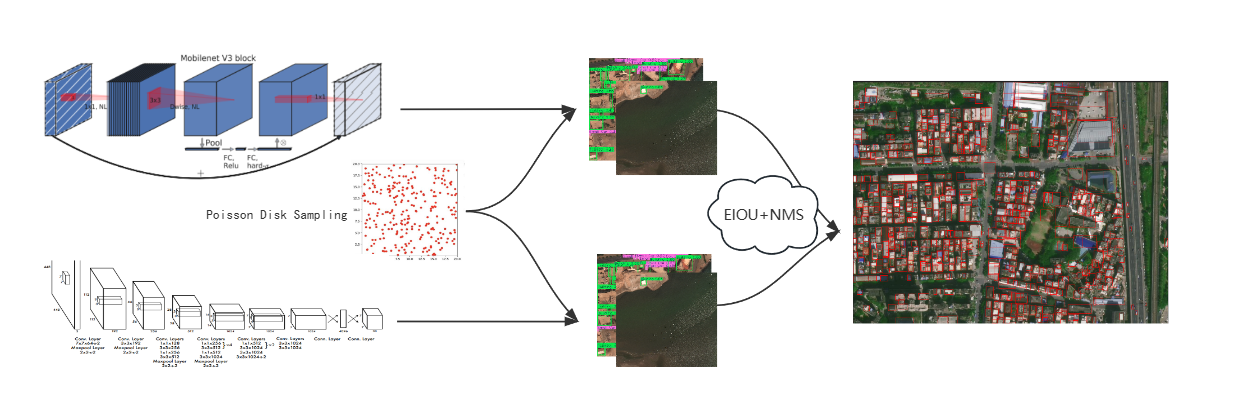
The methodological framework of this study can be summarized into four core steps:
-
•
1. Yolov11 and MobilenetV3 trainging
-
•
2. Poisson disk sampling and segmentation
-
•
3. Map the results detected on the small segmented images back to the original large-scale image
-
•
4. Re-train with synthetic data added proportionally.
Below is a detailed description of the steps:
First, we constructed a basic training dataset that includes a large number of labeled images for object detection. Based on this, we employed two advanced object detection models, YOLOv11 and MobileNetV3 SSD, to train the dataset, aiming to obtain preliminary object detection models. The selection of these two models was based on their good balance between speed and accuracy, as well as their broad applicability in various application scenarios.
To further improve the generalization and robustness of the models, we introduced an image segmentation technique based on Poisson disk sampling. Poisson disk sampling is a method capable of generating uniformly distributed point sets, with its mathematical foundation rooted in the Poisson process. Specifically, for a given region , a starting point is randomly selected, and other points are chosen according to certain rules (such as a minimum distance threshold ), until no new points meeting the conditions can be found within the entire region. This process can be formalized as:
where denotes the set of all finally selected points, and represents the Euclidean distance between any two points. Point sets generated through this method exhibit favorable spatial distribution characteristics, making them suitable for uniform sampling tasks in images.
We also use Bridson’s algorithm to accelerate the neighbor search process by utilizing a grid, thereby enhancing sampling efficiency. Initially, the sampling domain and the minimum sampling distance are defined, with the grid cell size set to . A starting point is randomly selected and added to the active list . Within the loop, a point is randomly chosen from , and candidate points are generated within the range of around . The distance between and its surrounding points is checked. If , is added to . This process is repeated until becomes empty.
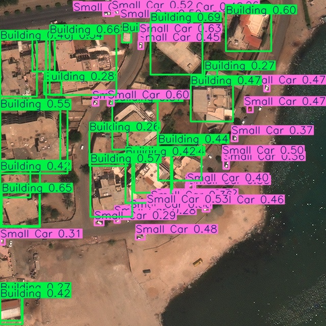
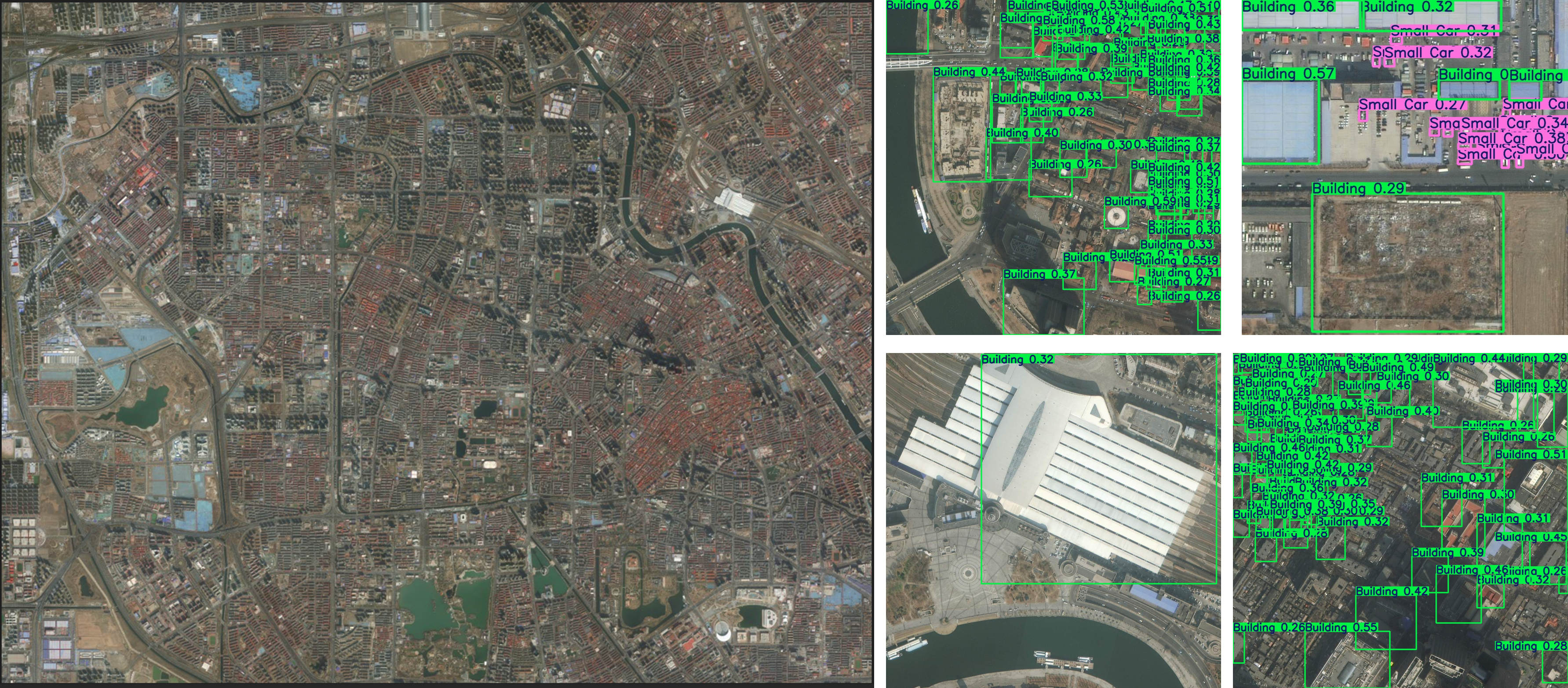
The trained YOLOv11 and MobileNetV3 SSD models were then used to perform object detection on each segmented sub-image. Since these sub-images are extracted from the original image, it is necessary to transform the position information of detected bounding boxes from the sub-image coordinate system back to the original image coordinate system. Assuming the dimensions of the original image are and those of the sub-image are , and the sub-image is located at the th row and th column of the original image, the position of the bounding box in the sub-image can be mapped back to the original image using the following matrix transformation formula:
Finally, the object detection results obtained through the aforementioned steps were used as synthetic data, which were mixed into the original training dataset at a certain ratio to construct an enhanced training set. This process not only increased the quantity of training samples but also introduced more viewpoint and scale variations, thereby enhancing the model’s adaptability to different scenarios.
Firstly, the training dataset is utilized to train object detection classifiers using the Yolo v11 and MobilenetV3 SSD algorithms, aiming to construct efficient object detection models.
Secondly, Poisson disk sampling technique is employed to perform sampling and segmentation on the detection images, ensuring the diversity and representativeness of the samples. The aforementioned trained Yolov11 and MobilenetV3 SSD models are then used to conduct object detection tasks on the segmented image patches, with the detection results accurately mapped back to the corresponding positions in the original images.
Lastly, the object detection outcomes obtained through the above processes serve as synthesized data, which are incorporated into the initial training dataset at a certain ratio to enhance the richness and diversity of the dataset.
Subsequently, model retraining and performance evaluation are conducted with the goal of further improving the model’s generalization capability and detection accuracy.
IV Experiments
IV-A Datasets
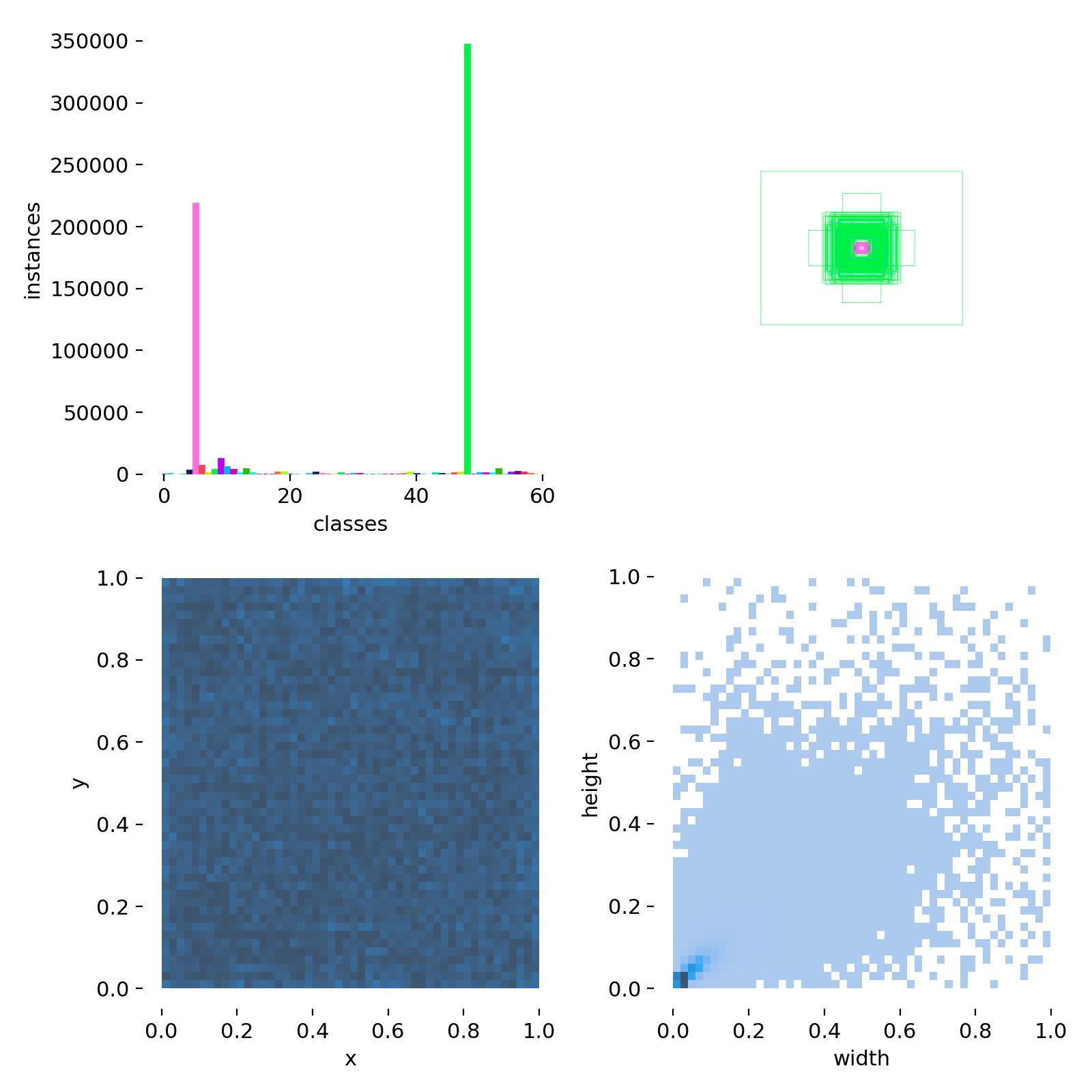
We utilized the XView dataset as our initial dataset. XView is a large-scale aerial image dataset containing over 1 million objects annotated with bounding boxes and class labels, designed for advancing computer vision tasks in satellite imagery analysis. To align with the test image dimensions, we cropped the images from the XView dataset into smaller images of size 640×640 and remapped the label positions accordingly.
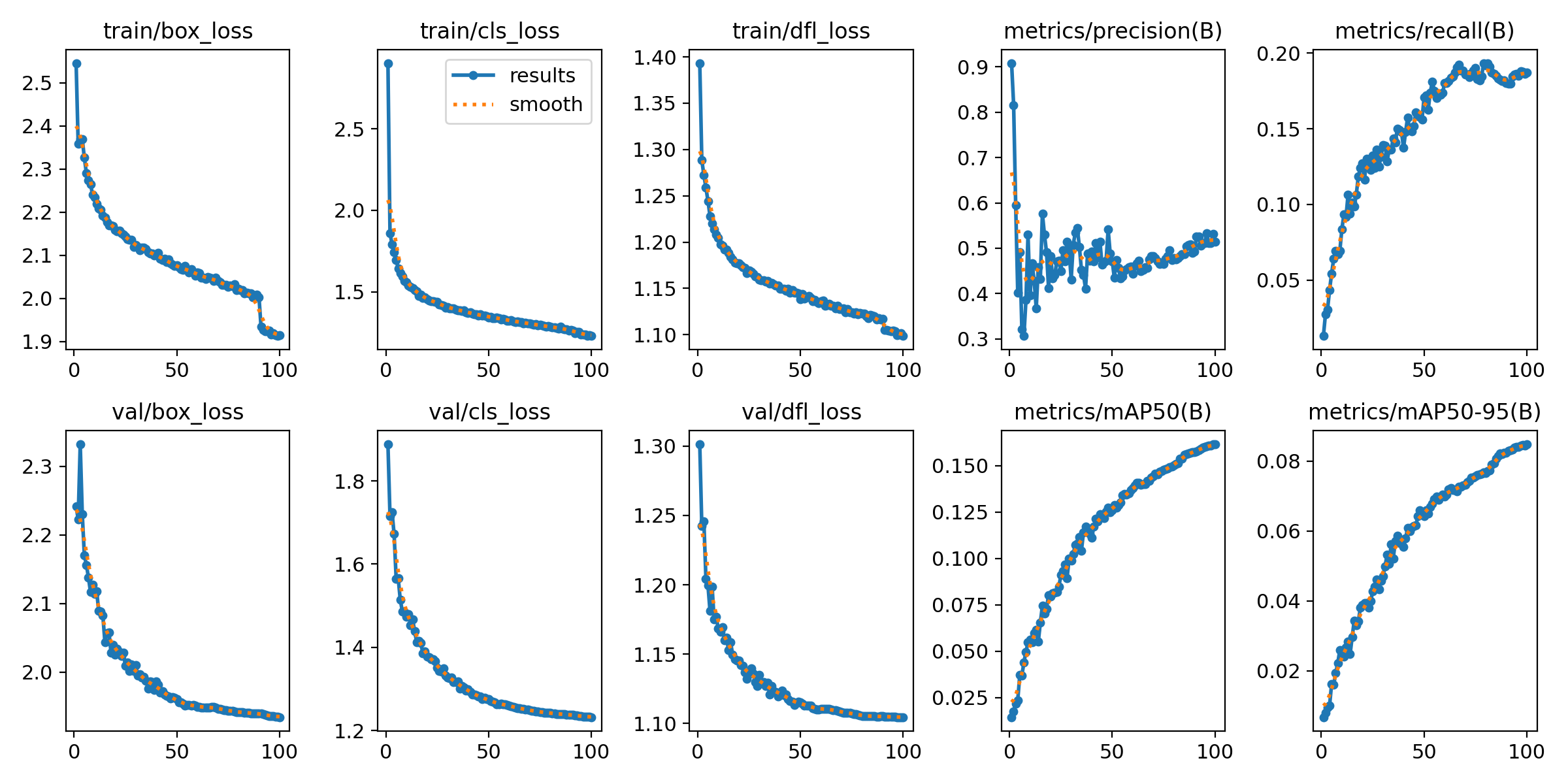
IV-B Initial training
Initial training was conducted on the XView dataset using both YOLOv11 and MobileNetV3-SSD. The training outcomes are presented as follows:

IV-C metrics
We traverse all the outcomes in the original dataset to evaluate new results, using the Intersection over Union (IoU) value to determine accuracy, where:
Here, the Area of Overlap refers to the area where the detection box overlaps with the ground truth box, and the Area of Union is the total area covered by both boxes minus the overlapping area. A result is deemed accurate if the IoU value exceeds 50
Subsequently, we assess the model using accuracy, precision, recall, and F1-score:
Where: - TP (True Positive): The number of instances correctly identified as positive by the model. - TN (True Negative): The number of instances correctly identified as negative by the model. - FP (False Positive): The number of instances incorrectly identified as positive by the model. - FN (False Negative): The number of instances incorrectly identified as negative by the model.
We also calculate the Mean Average Precision (mAP):
Here, represents the total number of categories, and denotes the average precision for the -th category.
Additionally, we measure the total time taken for detection to evaluate the efficiency of the model.
IV-D Comparisons
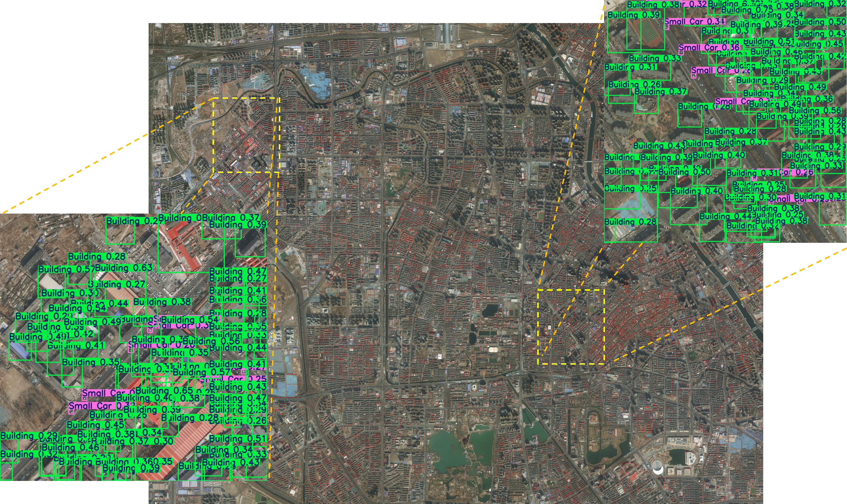
This study conducted experimental validation using a self-constructed high-resolution remote sensing image dataset that covers the entire urban areas of Shanghai, Tianjin, and Guangzhou. Given the performance variations of object detection models across different image cropping scales, this research specifically selected three standard cropping sizes: 320×320 pixels, 640×640 pixels, and 1280×1280 pixels, to systematically evaluate the robustness and adaptability of the proposed method.
To further explore the model’s generalizability and compare the advantages and disadvantages of different architectures, four advanced object detection frameworks—YOLOv5, MobileNet SSD, R-CNN, and Mask R-CNN—were chosen for comprehensive evaluation. Specifically, not only was the detection performance of each model analyzed on the complete original images, but also their performance was reassessed after processing the images using Poisson disk sampling cropping techniques, to investigate consistency and stability under various scenarios and conditions.
IV-E Comparing Result
We present the results as follows:
| Accuracy | Precision | Recall | F1-score | mAP | Testing time (s) | ||
| R-CNN | whole | 0.126261 | 0.166277 | 0.117213 | 0.137499 | 0.17 | 30.76 |
| 640-cut | 0.46192 | 0.433667 | 0.479543 | 0.455452 | 0.46 | 246080 | |
| Mask R-CNN | whole | 0.099741 | 0.119451 | 0.102114 | 0.110104 | 0.25 | 25.67 |
| 640-cut | 0.560104 | 0.605856 | 0.574377 | 0.589697 | 0.48 | 164288 | |
| YOLOv5 | whole | 0.202364 | 0.244687 | 0.223246 | 0.233476 | 0.37 | 2.12 |
| 640-cut | 0.861286 | 0.928461 | 0.811398 | 0.865991 | 0.64 | 7208 | |
| MobilenetSSD | whole | 0.179475 | 0.194703 | 0.230481 | 0.211086 | 0.33 | 1.34 |
| 640-cut | 0.832978 | 0.89368 | 0.789816 | 0.838544 | 0.65 | 6700 | |
| LRSAAs (ours) | 1280-cut | 0.821332 | 0.792565 | 0.89303 | 0.839804 | 0.64 | 13200 |
| 640-cut | 0.876679 | 0.823397 | 0.960912 | 0.886855 | 0.71 | 23760 | |
| 320-cut | 0.909311 | 0.936677 | 0.898025 | 0.916944 | 0.73 | 97416 |
IV-F Synthetic Data Training and Evaluation
To enhance the generalization and robustness of the models, this study performed random sampling on the original large-scale remotely sensed annotated images of Tianjin, generating a series of synthetic data samples with a size of 640×640 pixels. Subsequently, these synthetic data were integrated into the original dataset at a certain ratio, forming an extended dataset. Based on this extended dataset, we retrained two models: YOLO v11 and MobileNetV3-SSD.
After completing the model training, to verify the practical application effects of the improved models, we conducted detailed evaluations using large-scale remotely sensed manually annotated data from Shanghai and Guangzhou. The evaluation results are presented as follows:
| Percentage | Accuracy | F1-score | mAP |
|---|---|---|---|
| 0-1.0 | 0.876679 | 0.886855 | 0.71 |
| 0.2-0.8 | 0.899243 | 0.893432 | 0.72 |
| 0.4-0.6 | 0.897434 | 0.901213 | 0.72 |
| 0.6-0.4 | 0.912236 | 0.90003 | 0.73 |
| 0.8-0.2 | 0.910988 | 0.903456 | 0.72 |
The table reveals significant variations in performance metrics across different models and datasets. Initially, R-CNN exhibits relatively low accuracy, precision, and recall rates of 0.126261, 0.166277, and 0.117213 respectively on the whole dataset. However, its performance improves notably on the 640-cut dataset, particularly with an mAP value reaching 0.455452.
Mask R-CNN shows slightly better overall performance than R-CNN but lags behind it on the 640-cut dataset. YOLOv5 demonstrates superior performance on the entire dataset, especially in terms of precision, yet its F1-score is only 0.233476 on the 640-cut dataset, indicating certain limitations.
MobilenetSSD performs moderately well on the whole dataset but excels on the 640-cut dataset, achieving high accuracy and mAP values of 0.861286 and 0.865991 respectively. This suggests that the model has good generalization capabilities under specific conditions.
Notably, LRSAA (our method) outperforms all other models across all test conditions. Particularly on the 640-cut and 320-cut datasets, it displays higher key metrics such as accuracy, precision, recall, and F1-score. Additionally, LRSAA’s mAP values on these datasets significantly surpass those of other models, demonstrating its superiority in object detection tasks.
In summary, while each model’s performance varies across different datasets, LRSAA consistently showcases advantages in multiple evaluation metrics, especially when dealing with smaller datasets. This indicates not only improved accuracy in object detection but also excellent performance under resource-constrained conditions, providing strong support for practical applications.
V Conclusion and Future Work
V-A Conclusion
In this paper we present a novel framework for large-scale remote sensing image target recognition and automatic annotation, termed LRSAA. This approach integrates YOLOv11 and MobileNetV3-SSD object detection algorithms through ensemble learning, enhancing model performance while reducing computational resource demands. The use of Poisson disk sampling segmentation and the EIOU metric optimizes the training and inference processes, achieving a commendable balance between accuracy and speed. The LRSAA model, trained and evaluated using the XView dataset and applied to Tianjin’s remote sensing images, demonstrated significant improvements in recognition capabilities when synthetic data was incorporated. This work contributes to the advancement of remote sensing image analysis, enabling more efficient and accurate geographic information acquisition and utilization.
V-B Future Work
Looking ahead, there are several avenues for future research to build upon the LRSAA framework. First, the integration of more advanced deep learning models and algorithms could further enhance the accuracy and efficiency of object detection in remote sensing images. Exploring the potential of transformer-based models or other cutting-edge architectures may provide additional performance gains.
Second, the application of the LRSAA framework to a broader range of remote sensing datasets and scenarios could validate its generalizability and robustness. Testing the model’s performance under various environmental conditions and image qualities would be crucial for its practical deployment.
Third, the development of more sophisticated data augmentation techniques and synthetic data generation methods could further improve the model’s ability to handle diverse and complex real-world scenarios. This includes incorporating various weather conditions, lighting changes, and occlusions.
Fourth, investigating the computational efficiency of the LRSAA framework on different hardware platforms, such as edge devices and cloud computing environments, could provide insights into its scalability and practicality for large-scale applications.
Lastly, the exploration of real-time object detection capabilities within the LRSAA framework is essential for time-sensitive applications such as disaster monitoring and dynamic environmental tracking. Optimizing the model for real-time performance without compromising accuracy is a challenging but important direction for future work.
References
- [1] Howard, Andrew G. ”Mobilenets: Efficient convolutional neural networks for mobile vision applications.” arXiv preprint arXiv:1704.04861 (2017).
- [2] A. Howard, M. Sandler, G. Chu, L.-C. Chen, B. Chen, M. Tan, W. Wang, Y. Zhu, R. Pang, V. Vasudevan, Q. V. Le, and H. Adam, ”Searching for MobileNetV3,” in Proc. IEEE Int. Conf. Comput. Vis. (ICCV), October 2019.
- [3] D. Li, A. Zhou, and A. Yao, ”HBONet: Harmonious Bottleneck on Two Orthogonal Dimensions,” in Proc. IEEE Int. Conf. Comput. Vis. (ICCV), October 2019.
- [4] D. Biswas, H. Su, C. Wang, A. Stevanovic, and W. Wang, ”An automatic traffic density estimation using Single Shot Detection (SSD) and MobileNet-SSD,” Physics and Chemistry of the Earth, Parts A/B/C, vol. 110, pp. 176-184, 2019.
- [5] Nateghi, Mohammadjavd. ”Detection, recognition and tracking cars from uav based implementation of mobilenet-single shot detection deep neural network on the embedded system by using remote sensing techniques.” Journal of Radar and Optical Remote Sensing and GIS 3.2 (2020): 53-62.
- [6] R. Khanam and M. Hussain, ”YOLOv11: An Overview of the Key Architectural Enhancements,” arXiv preprint arXiv:2410.17725, 2024.
- [7] Redmon, J. ”You only look once: Unified, real-time object detection.” Proceedings of the IEEE conference on computer vision and pattern recognition. 2016.
- [8] Pham M-T, Courtrai L, Friguet C, Lefèvre S, Baussard A. YOLO-Fine: One-Stage Detector of Small Objects Under Various Backgrounds in Remote Sensing Images. Remote Sensing. 2020; 12(15):2501. https://doi.org/10.3390/rs12152501
- [9] Xu D, Wu Y. Improved YOLO-V3 with DenseNet for Multi-Scale Remote Sensing Target Detection. Sensors. 2020; 20(15):4276. https://doi.org/10.3390/s20154276
- [10] Z. Zakria, J. Deng, R. Kumar, M. S. Khokhar, J. Cai and J. Kumar, ”Multiscale and Direction Target Detecting in Remote Sensing Images via Modified YOLO-v4,” in IEEE Journal of Selected Topics in Applied Earth Observations and Remote Sensing, vol. 15, pp. 1039-1048, 2022, doi: 10.1109/JSTARS.2022.3140776
- [11] Hou Y, Shi G, Zhao Y, Wang F, Jiang X, Zhuang R, Mei Y, Ma X. R-YOLO: A YOLO-Based Method for Arbitrary-Oriented Target Detection in High-Resolution Remote Sensing Images. Sensors. 2022; 22(15):5716. https://doi.org/10.3390/s22155716
- [12] J. Lin, Y. Zhao, S. Wang and Y. Tang, ”YOLO-DA: An Efficient YOLO-Based Detector for Remote Sensing Object Detection,” in IEEE Geoscience and Remote Sensing Letters, vol. 20, pp. 1-5, 2023, Art no. 6008705, doi: 10.1109/LGRS.2023.3303896.
- [13] Cook, Robert L. ”Stochastic sampling in computer graphics.” ACM Transactions on Graphics (TOG) 5.1 (1986): 51-72.
- [14] Robert L. Cook. 1986. Stochastic sampling in computer graphics. ACM Trans. Graph. 5, 1 (Jan. 1986), 51–72. https://doi.org/10.1145/7529.8927
- [15] Lagae, Ares, and Philip Dutré. ”A comparison of methods for generating Poisson disk distributions.” Computer Graphics Forum. Vol. 27. No. 1. Oxford, UK: Blackwell Publishing Ltd, 2008.
- [16] Wang, Tong. ”Poisson-disk sampling: Theory and applications.” Encyclopedia of Computer Graphics and Games. Cham: Springer International Publishing, 2024. 1424-1431.
- [17] Zhang, Yi-Fan, et al. ”Focal and efficient IOU loss for accurate bounding box regression.” Neurocomputing 506 (2022): 146-157.
- [18] Zheng, Zhaohui, et al. ”Distance-IoU loss: Faster and better learning for bounding box regression.” Proceedings of the AAAI conference on artificial intelligence. Vol. 34. No. 07. 2020.