Risk Assessment for Autonomous Landing in Urban Environments using Semantic Segmentation
Abstract
In this paper, we address the vision-based autonomous landing problem in complex urban environments using deep neural networks for semantic segmentation and risk assessment. We propose employing the SegFormer, a state-of-the-art visual transformer network, for the semantic segmentation of complex, unstructured urban environments. This approach yields valuable information that can be utilized in smart autonomous landing missions, particularly in emergency landing scenarios resulting from system failures or human errors. The assessment is done in real-time flight, when images of an RGB camera at the Unmanned Aerial Vehicle (UAV) are segmented with the SegFormer into the most common classes found in urban environments. These classes are then mapped into a level of risk, considering in general, potential material damage, damaging the drone itself and endanger people. The proposed strategy is validated through several case studies, demonstrating the huge potential of semantic segmentation-based strategies to determining the safest landing areas for autonomous emergency landing, which we believe will help unleash the full potential of UAVs on civil applications within urban areas.
Keywords:
Autonomous Landing Semantic Segmentation UAVs Risk Assessment Emergency Landing1 Introduction
The rapid development of Unmanned Aerial Vehicles (UAVs) has allowed an increase in their use in all sorts of applications, especially civilian, ranging from simple entertainment through surveillance and infrastructure inspection, crossing the areas of professional photography, precision agriculture, and aerial transportation, among others [1, 23]. However, even with the significant progress on UAVs, their deployment in populated areas has been hindered due to safety concerns. Most applications are restricted to areas devoid of people due to the latent risk that flying objects pose on them or on property in the event of malfunction or human errors, limiting the full potential of UAVs within urban spaces.
1.1 Unmanned Aerial Vehicle Regulations
Acordingly, regulations require to present risk mitigation measures to local authorities to allow flight missions in civilian spaces. In most cases, strategies entail avoiding densely populated areas and/or implementing emergency response plans.
The European Union Aviation Safety Agency (EASA) [4] adopt a risk-based approach that do not distinguish between leisure or commercial activities, but the weight, specifications and operation intended to undertake. To fly over people, the EASA only authorizes drones weighting under , but never under "assemblies of people". In any case, it suggest to minimize the time flying over people. For CE class 2, the general rule is to keep the UAV at a lateral distance from any uninvolved person that is not less than the height at which the drone is flying and never fly closer than 30 meters horizontally from any uninvolved person. For the rest of categories, it is needed to ensure that no uninvolved people are present within range of the operation.
For the U.S. Federal Aviation Administration (FAA) [3], the rule for operating drones under in the National Airspace System (NAS) is the Code of Federal Regulations Part 107 [2], referred to as the Small UAV Rule. In section 39 of that rule specifies that no person may operate a small UAV over a human being unless that human being is directly participating in the operation, is located under a covered structure or inside a stationary vehicle that can provide reasonable protection from a falling small UAV or if the operation meets the requirements of the subpart D of this part, which prescribes the eligibility and operation requirements for civil small UAV to operate over human beings. This subpart defines the requirements for different categories, but explicitly forbids all of them to operate in sustained flight over open-air assemblies of human beings unless otherwise authorized by the Administrator.
Following those rules, the Joint Authorities for Rulemaking on Unmanned Systems (JARUS) created a document of guidelines for aerial work operations called Specific Operations Risk Assessment (SORA) [29]. It defines the risk as the combination of the frequency (probability) of an occurrence and its associated level of severity. Many categories of harm arise from any given occurrence, so, it defines three categories of harm:
-
•
Fatal injuries to third parties on the ground
-
•
Fatal injuries to third parties in the air
-
•
Damage to critical infrastructure
The consequence of an occurrence is designated as harm of some type. Thus, it defines two classes of risk: Ground Risk (GRC) and Air Risk (ARC). Each class has its own defined intrinsic risk. For UAS smaller than 1m of span, ground risks levels range from 1 to 8, and air risk from A to D. The calculus of those risks are based on UAV specifications, operation scenario and airspace. More specifically, the GRC relates to the unmitigated risk of a person being struck by the UAV (in case of loss of control) derived from the intended operation and the UAV lethal area, as shown in Table 1.1. As it can be seen, the most riskiest operation are over gatherings of people, what in regulations is mentioned as "assembly of people".
| o 1.0 X[1.5l] X[0.5c] Operational Scenarios | Class Level |
|---|---|
| VLOS/BVLOS over controlled ground area | 1 |
| VLOS in sparsely populated environment | 2 |
| BVLOS in sparsely populated environment | 3 |
| VLOS in populated environment | 4 |
| BVLOS in in populated environment | 5 |
| VLOS over gathering of people | 7 |
| BVLOS over gathering of people | 8 |
Following the SORA methodology, once the GRC is obtained, mitigation strategies should be applied to reduce the Final Ground Risk Class. This strategies are classified as:
-
•
M1 – means to reduce the number of people at risk.
-
•
M2 – means to reduce the energy absorbed by the people of the ground upon impact.
-
•
M3 – an Emergency Response Plan (ERP) is in place, operator validated and effective.
The ERP should be defined by the applicant in the event of loss of control of the operation for emergency situations where the operation is in an unrecovarable state and in which the outcome of the situation highly relies on providence, could not be handled by a contingency procedure or when there is grave and imminent danger of fatalities. The ERP is expected to cover a plan to limit the escalating effect of a crash. In this context and depending on national laws, Autonomous Landing can be implemented as M3 mitigation strategy.
1.2 Autonomous Landing
Existing rotary-wing UAVs offer limited Autonomous Landing capabilities, which is one of the main limitations for expanding the applications into urban populated areas. Although some sophisticated UAVs may be equipped with safety mechanisms for emergency situations, the majority of currently available drones are constrained by return-to-home protocols in the event of malfunctions. This normally involves recording the take-off location, and, when communication is lost, returning to it autonomously and descending slowly. The device may also emit lights and sounds to alert unaware bystanders in the area. Nevertheless, such strategies do not warranty the safety of the landing missions, especially during a system failure or a battery shortage. More advanced drones could search for pre-known visual tags for landing [7], but this involves previously preparing the area, which is not ideal for most applications, especially those covering large areas, unstructured scenarios, or spaces with moving people or vehicles, as is common in urban areas.
Hence, AL in urban environments is a complex and open research problem, due to the enormous variety of scenarios present in cities, where the UAV operates within an unknown and unstructured environment under varying conditions, navigating alongside individuals, vehicles, animals, and other moving entities with unknown dynamics. When a dangerous situation occurs, the drone must find a Safe Landing Zone (SLZ), which is defined as the best available space to land without causing any kind of damage, or the area where the risk of material damage and hurting people is minimized. This has proven to be very challenging due to the diverse and changing nature of urban populated areas. Proposing a solution that can be readily deployed, leveraging the existing components integrated into the UAV, has the potential to greatly enhance their practical applications in urban settings.
In this regard, this work proposes the use of a monocular camera attached to the UAV coupled with computer vision and state-of-the-art Deep Learning algorithms to analyze the scene and assess the risk of accidents that may produce significant material damage or, even worse, hurt human beings during emergency landing situations. For this, it will be used a semantic segmentation network based on Visual Transformers and trained on UAV-obtained datasets, which are composed of aerial views of urban areas with labels at the pixel level of the most common classes for this context, such as people, cars, roads, vegetation, etc. The semantic segmentation model will provide pixel-level classification of RGB images, which in turn will be used to create a risk map assessing the risk of material damage or human accidents in the areas beneath the drone. This risk map can be used later to perform further analysis and help the UAV with the decision-making process to minimize the risk of accidents, making the system more reliable and resilient. No 3D information of terrain will be accounted for (solely considerations that walls, doors, windows and other similar objects generate a specific risk level because of verticality), and suppose UAV work space is clear so there is no risk of air collision.
This proposal aims to furnish valuable insights to an Uncrewed Aircraft System (UAS) for a comprehensive understanding of the dynamic urban environment, particularly in areas where people and motor vehicles contribute to a multifaceted scenario.
This work is organized as follows. Section 2 contains a discussion on related work on autonomous landing in general. Section 3 describes the different modules that comprise the proposed strategy. Experimental results are discussed and evaluated in Section 4. Finally, the conclusions and future work are presented in Section 5.
2 Related Works: Vision-Based Autonomous Landing
Since [14] helped pave the way to Deep Learning, advances in the field of Computer Vision (CV) and Machine Learning (ML) allowed the evolution of Autonomous Landing (AL) tasks from simple state machines using ground beacons and radio telemetry sensors such as GPS, to a great diversity of techniques using only RGB cameras most of the time.
Some of the first works reported in the literature were devoted to the detection of previously known visual markers [20], to avoid hazardous terrain [12] or to use visual feedback to provide additional awareness to UAVs. These methods were based on extracting and then tracking traditional features from images obtained from a monocular camera as done in [24, 13]. However, vision was used mainly as an assistance system.
Furthermore, works based on people detection, such as [17, 5], allowed the incorporation of a more safety-oriented approach to autonomous landing, which was achieved by detecting people to avoid human accidents. Using basic computational vision tools, it is possible to find areas to land in simple and controlled scenarios. However, those tools become useless when the real environments in populated areas become too complex. The main troubles presented in previous works are not generalizing enough the features like heads of people, not accounting for changes in perspective, dealing with occlusion and scene movement, or restricting themselves to a handful of scenarios.
Subsequent works like [10] started focusing on improving people detection, being people the most critical factor during autonomous landing missions, by obtaining density maps from the people location directly from the images, to get people count and position data in crowded scenes. Those density maps were extracted using classical tools as Probability Density Function using FAST, from videos taken from airborne cameras above the crowds. However, this approach still fails with perspective variations.
Later on, proposals on the use of machine learning tools such as Convolutional Neural Networks (CNN) flourished, as these tools were capable of generalizing a wide variety of environments and situations as shown in [8]. However, few works have been destined for determining UAVs’ safe landing zones.
Works such as [16, 15, 26, 27] use a Deep Neural Network (DNN) to try to find landing zones free of people. In [28] a lightweight network is used to overestimate the density map of the crowd to prevent the drone from landing near any person. In addition, [16] uses the pitch and altitude information provided by the drone to feed it to the DNN as an additional channel called the perspective map, from which a density map drawn on the head’s plane is generated. This plane, which is where the heads are in average in the real world, prevents the system from underestimating people and helps to decide where to land. [8, 9] use lightweight networks to infer density maps based on a Bayesian-Loss network that is very suitable for execution in embedded systems. Then, in [11], using the density map, the authors find areas devoid of people suitable for landing, and track them with Kalman filters coupled with the Hungarian algorithm.
However, most proposals are hard to validate in real scenarios. Thus, [25] proposes a framework for safe real-time and a thorough evaluation of vision-based AL in populated scenarios, using photo-realistic virtual environments and physics-based simulation. Then, software/hardware-in-the-loop can be used to test the performance of the algorithms beforehand. The final validation stage consists of a robot-in-the-loop evaluation strategy. To this end, a real drone must perform autonomous landing maneuvers in real-time, with an avatar drone in a virtual environment mimicking its behavior, while the detection algorithms run in the virtual environment (virtual reality to the robot). The authors also propose different metrics to quantify the performance of landing strategies, establishing a baseline for comparison with future work on this challenging task and analyze them through several randomized iterations.
Nevertheless, the previous works are restricted to avoid accidents involving humans and do not account for potential material damage or indirect accidents involving people. [21] proposes implementations of state-of-the-art techniques and tools in the search for SLZ for UAVs. In their article, the authors propose the use of different modules to create an annotated surroundings map, with landing sites and no-fly zones around people locations, and continuously check for paths towards SLZ. The approach considers finding people and different kinds of risks while also checking for a flat safe landing zone. However, the design of the system is focused in a sparse and less dynamic scenarios. Finally, [6] uses a binocular-LiDAR to find flat areas to land with a network doing semantic segmentation simultaneously. This double function helps the system understand the morphology and semantic features of the terrain, selecting SLZ in complex environments with very high accuracy. This method is good to give terrain context to the UAV, but people and other urban agents are not accounted for.
Although some advances can be found in the recent literature, autonomous landing in dynamic urban unstructured environments continues to be a very complex open problem, where a lot of research effort is still required in order to have more reliable solutions. In this regard, the present work proposes a vision-based strategy for risk assessment in the context of autonomous landing in complex unstructured urban scenarios. The strategy consists in using a semantic segmentation DNN based on modern visual transformers to provide context to the UAV about the area below it. This is done by identifying classes of terrain and objects that can be used in the decision-making processes to avoid human accidents and material damage. Furthermore, the inferred image from semantic segmentation is then mapped to a heat map that assesses the potential risk of accidents involving people, directly or indirectly, as well as potential material damage to expensive infrastructure or obstacles such as cars or to the drone itself. The proposed strategy can be easily used further as a framework for smart decision-making during emergency landing protocols. The risk map can be coupled with multi-objective optimization techniques to take desitions on where to land, prioritizing the zones with less risk, even it could be elevated. The strategy is validated in various case studies, showcasing the huge potential of this proposal to assess risk confidently in autonomous landing in urban complex unstructured scenarios.
3 General Approach
The proposed risk assessment approach for AL is composed of two stages: Semantic Segmentation and Clustering by Risk Level.
3.1 Semantic Segmentation
Semantic Segmentation (SS) is the task of classifying images into different categories at a pixel-wise level. This kind of classification is used because it produces better information on the context and location of the segmented objects. Historically, this task has improved greatly with the use of CNNs, notably with the introduction of the first U-Net proposed in [19]. More recently, the techniques developed for Natural Language Processing have generated great interest because they include diverse mechanisms in a model known as Transformer, that efficiently process vast and complex datasets. This model proposed by [30] started to infuse into other fields because it learns the dependencies between distant positions of the input and generates context. These context-aware capabilities have allowed state-of-the-art models of SS to be very efficient and accurate. Models such as SegFormer [31] have a straightforward implementation that enables many downstream applications like the one presented in this paper, in addition to having a performance that makes it one of the best models for SS.
Because Semantic Segmentation works at the pixel level, to measure performance of the SS models the community uses mean Intersection over Union (mIoU) and Dice Coefficient (DSC, also known as F1 Score) metrics, which are similarity coefficients between the predicted classes and the ground truth.
Intersection over Union defined in Eq. 1 serves as the fundamental metric to quantify the overlap between the predicted and ground truth areas. Higher values indicate better alignment between the predicted and actual regions, meaning a more accurate model.
| (1) |
So, mIoU is the average segmentation performance for all classes.
| (2) |
The DSC defined in 3 is the harmonic mean of precision and recall. In other words, it is the coefficient between detecting the target correctly and not detecting other classes.
| (3) |
3.1.1 Model
The implemented model for SS of images on this proposal is the SegFormer. This sophisticated segmentation architecture that integrates Transformers and Multilayer Perceptron (MLP) blocks was proposed by [31]. Its design offers the advantages of minimal parameters, fast training, and extensive computational capacity. The network utilizes an auto-encoder structure, as can be seen in Fig. 1. The encoder incorporates four transformer blocks that can produce features at multiple scales. The decoder employs an MLP to combine multi-scale features, complemented by an “UpSample” layer to restore the image resolution.
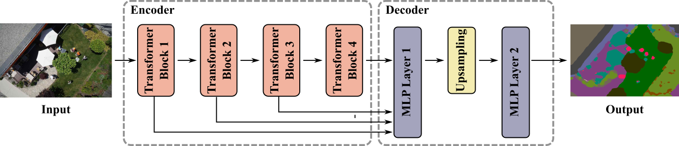
The simple and lightweight design of SegFormer offers a series of models with different sizes, from SegFormer-B0 to SegFormer-B5, allowing the flexibility of choosing the model best suited for the application needs. The SegFormer chosen for this task was the one based on the backbone of MiT-B0, which is the lightest and fastest version. This selection was based on the assumption that this model has to run in real-time on a computer embedded onboard the UAV at a sufficiently high rate to guarantee a safe landing.
The model was implemented using the HuggingFace library of the SegFormer [18], which offers tools to build and test machine-learning architectures. The implemented model can receive inputs of “any size”, reducing the preprocessing. The output is one-fourth of the size of the input, so in training it was required to up-sample 4 times the output to compare it to ground truth.
3.1.2 Dataset
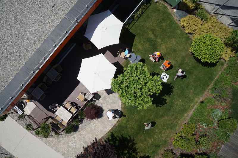
A key element for training DNN is the dataset. To take advantage of the SegFormer, it was finetuned on the Semantic Drone Dataset (SDD) [22], a dataset designed to enhance the safety of autonomous drone flight and landing procedures through improved semantic comprehension of urban environments. It is publicly available and contains high-resolution aerial images of size pixels (Mpx) from bird’s eye view, acquired at altitudes between to meters above ground.
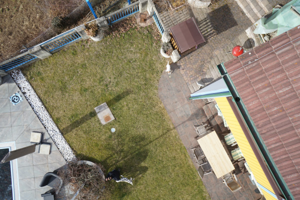
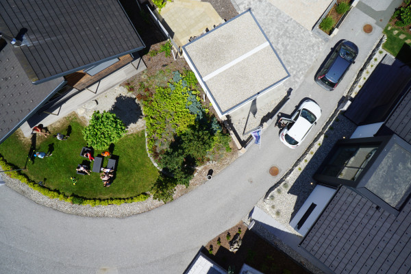
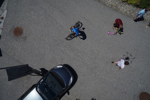
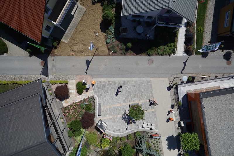
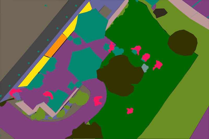
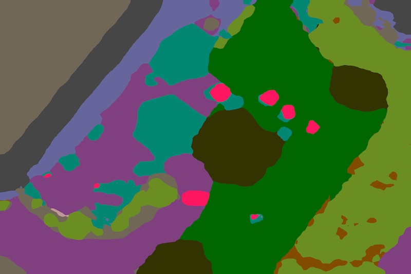
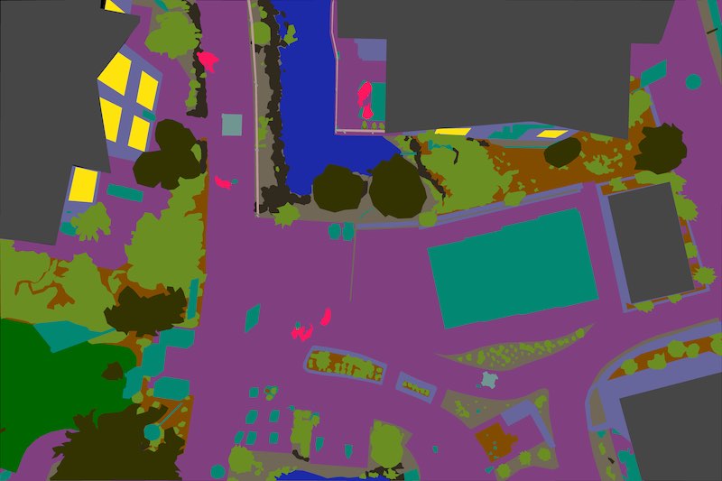
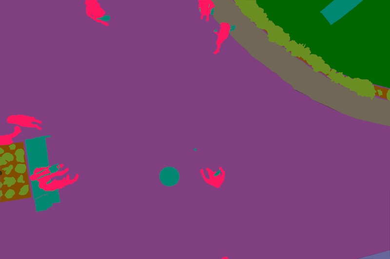
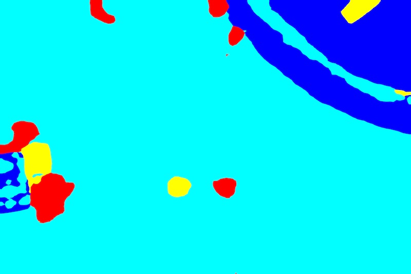
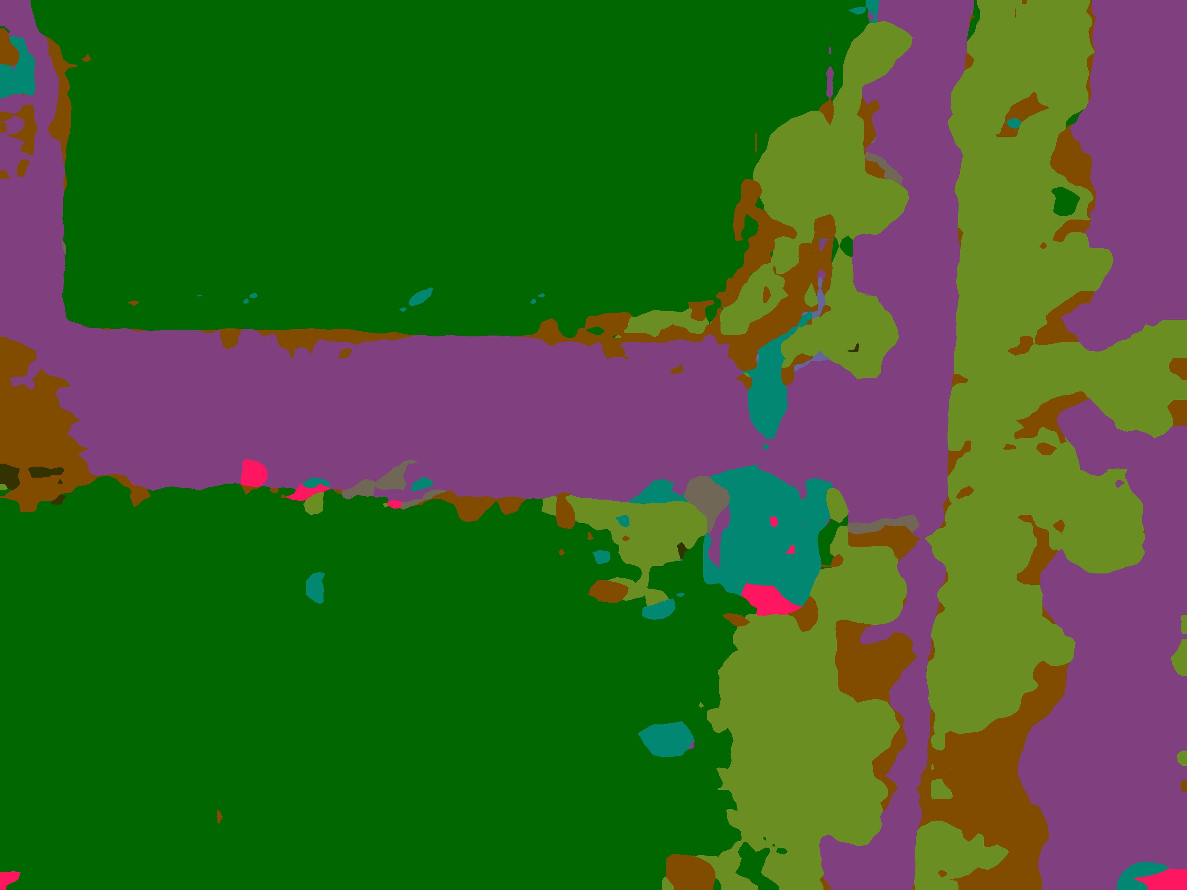
Fig. 2 depicts some samples of this dataset. Annotations are provided for SS and include of the most common classes from outdoor environments, including people, cars, vegetation, grass, pavement, water, animals, etc. Table 2 presents a comprehensive overview of the dataset classes alongside their respective colors. Additionally, the proposed risk classification is displayed along with its corresponding color, as will be explained in Subsection 3.2
| Semantic | Risk | |||
|---|---|---|---|---|
| Segmentation | Level | |||
| Class | Label | RGB | Class | RGB |
| 0 | background | 0 | ||
| 1 | dirt | |||
| 2 | grass | |||
| 3 | gravel | |||
| 4 | ar-marker | |||
| 5 | paved-area | 1 | ||
| 6 | vegetation | |||
| 7 | rocks | 2 | ||
| 8 | pool | |||
| 9 | roof | |||
| 10 | fence | |||
| 11 | fence-pole | |||
| Semantic | Risk | |||
|---|---|---|---|---|
| Segmentation | Level | |||
| Class | Label | RGB | Class | RGB |
| 12 | water | 3 | ||
| 13 | wall | |||
| 14 | window | |||
| 15 | door | |||
| 16 | bicycle | |||
| 17 | tree | |||
| 18 | bald-tree | |||
| 19 | obstacle | |||
| 20 | dog | 4 | ||
| 21 | car | |||
| 22 | conflicting | |||
| 23 | person | 5 | ||
To finetune the SegFormer, the SDD was divided as follows: for training, for validation, and for testing. Then, to increase the diversity of the data, a data augmentation technique was used to increase four times the number of images. In order to generalize aerial footage taken from a UAV, the transformations applied to augmented images included only brightness and contrast change, rotations, flips and random crops (transformations likely to happen to footage get with UAVs).
3.2 Clustering by Risk Level
A large number of classes on the semantic segmentation model may provide unnecessary information and affect negatively its metrics. Besides, to assess the risk of an scene using all classes individually could be more challenging, so it is useful to group classes with similar risk profile.
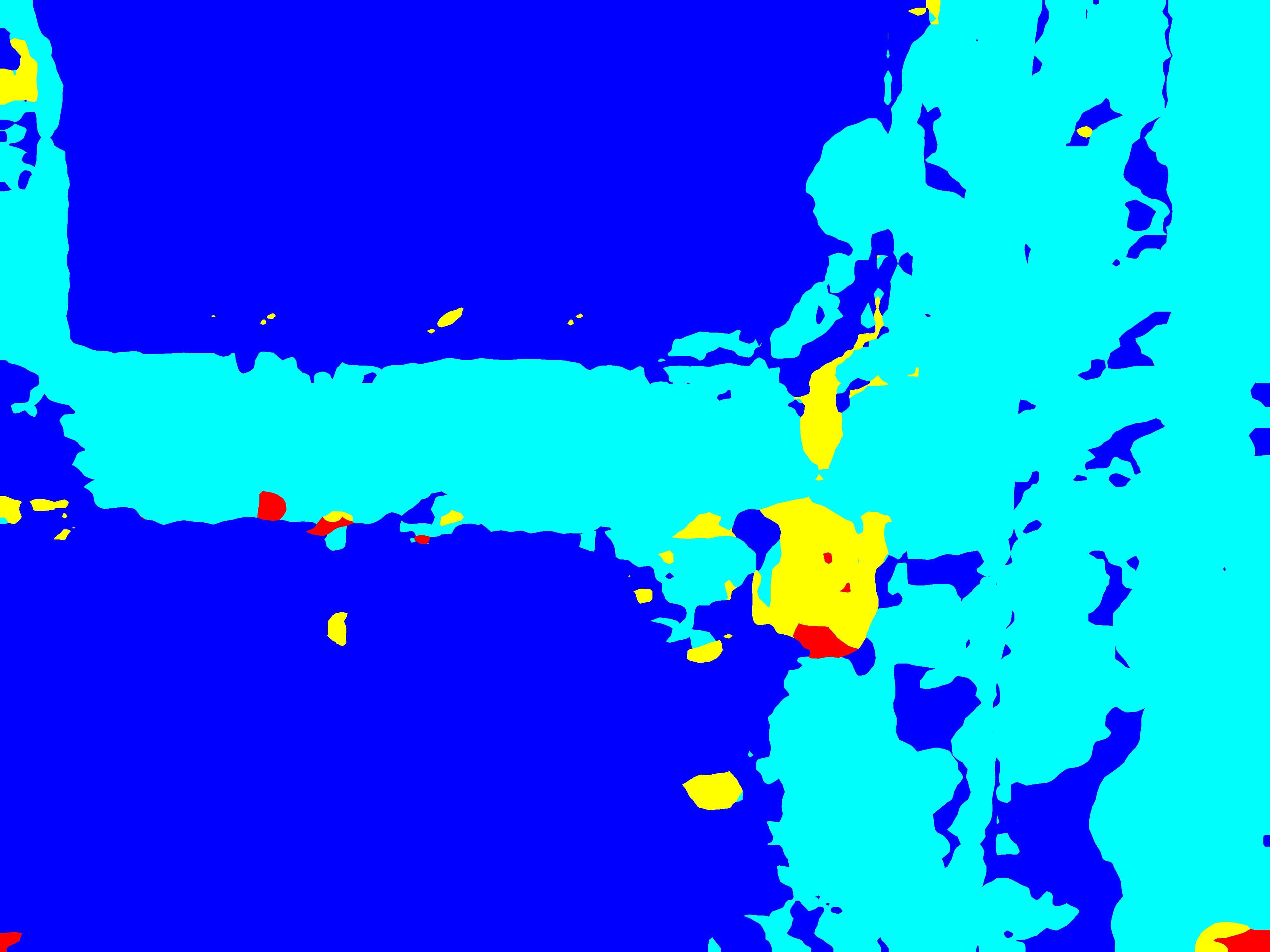
Following the SORA, it was decided to define different levels of risk, based on possible human injuries (which establishes the highest risk), material damage, preservation of the integrity of the drone and the identification of ideal zones for landing, being 0 the most ideal area to land, and 5 the riskiest, as defined in Table 3.2. This parameter was selected to reflect the intrinsic risk class proposed by SORA but it could be easily adjusted for different applications. Depending on the risk associated, the segmented classes are classified as observed in Table 2.
| o 1.0 X[0.5c] X[1.7l] Risk Level | Definition |
|---|---|
| 0 | Ideal landing zones, including grass, dirt, gravel, and predefined markers. |
| 1 | Low level of material damage or damage to the UAV itself. |
| 2 | Moderate risk of loosing or damaging the UAV, along with low risk of material damage. |
| 3 | This level includes important material damage, the imminent risk of losing or critically damaging the drone, and the moderate risk of indirectly hurting people. It includes the classes water, tree, window, wall, among others. |
| 4 | This level comprises indirect risk of hurting people, direct risk of hurting fauna, and conflicting regions where there is uncertainty about the presence of people in the area. |
| 5 | This level represents the maximum risk and considers the direct risk of hurting people. |
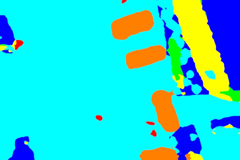
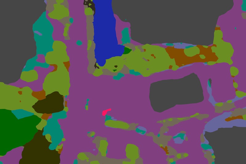
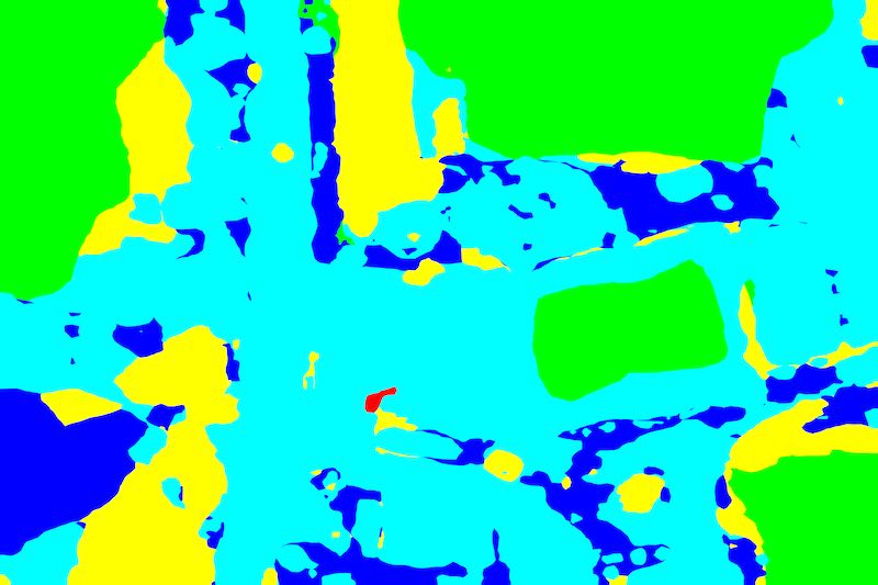
In this work, conversion from semantic segmentation classes to risk levels is performed after inference, so the model can learn the characteristics of the same kind of classes and not lose generalization. Fig. 3 shows an example of the different stages of the risk assessment strategy.
4 Experimental Validation
4.1 Experimental Setup
Development, training the model and testing were carried out with Python virtual environments on two desktop computers running on Ubuntu 20.04 equipped with processors Intel(R) Core(TM) i9-9900K and i7-8700K CPU and graphic cards NVIDIA GeForce RTX 2080 Ti and GTX 1080 Ti. An NVIDIA Jetson AGX Xavies (32 GB) was used only to obtain the minimum frame rate at which the SS model and the risk assessment proposal will run.
The model was developed using Pytorch libraries and the SegFormer implementation by the HuggingFace community. At the HuggingFace Hub, NVIDA offers a MiT-B0 SegFormer encoder pretrained on Imagenet-1k which was finetuned on the SDD.
4.2 Experimental Results
Different model trainings were conducted to assess the best configuration of the model for the application. The training dataset with data augmentation and all its classes were fed into the model. After epochs, the validation metrics were still improving, so the model was trained for further epochs. At epochs, the metrics started to plateau, and therefore training was stopped to avoid overfitting. After integrating the SS model to the risk assessment pipeline, the system produced a minimum frame rate of 14 FPS at the Jetson Xavier, showing its viability to integrate the proposal to the flight system of certain UAVs. In terms of semantic segmentation, the results given by the model trained match the reported in the literature.
| Experiment | Acc. | Mean IoU | F1 Score | Bal Acc. |
|---|---|---|---|---|
| Class Segmentation | 0.8831 | 0.4138 | 0.4888 | 0.5754 |
| Risk Levels | 0.8976 | 0.5811 | 0.6725 | 0.7110 |
The evaluation was carried out in the test set, producing the results shown in Table 4. It can be seen that grouping categories by risk level implies reducing the number of classes, which also helps to improve the metrics obtained, as seen in Table 4. This suggests that risk-level conversion is able to cope with inaccuracies in semantic segmentation, which, in turn, suggests that the process of making decisions about safe landings based on risk levels is more robust than making the decision directly on semantic segmentation. Fig. 4 shows the confusion matrix when the prediction is transformed to risk levels. Risk levels and , which could be considered desirable locations to land, had a correct labeling above . The same for level . However, in the case of risk levels , and , accuracy falls below , something not so desirable, especially for the most critical level . Most classes and by extension, risk levels, were normally predicted to be of the classes with lower risk for up to . Those risk levels contain the most common and extensive classes in the datasets, i.e. grass, dirt, paved-area, etc. The reason to this is that normally in the field of semantic segmentation, "background" classes as those mentioned earlier, compose the major part of the images due to its nature, technically unbalancing the dataset, in an unavoidable way. Even more, those classes encircle all the others, this being the main reason why all other classes have a considerable percentage being predicted as those. Thus, it is preferable to have more false positives on the high risk level classes than false negatives. In this regard, one strategy is to dilate the high levels areas, so the resulting prediction could be safer for critical classes.
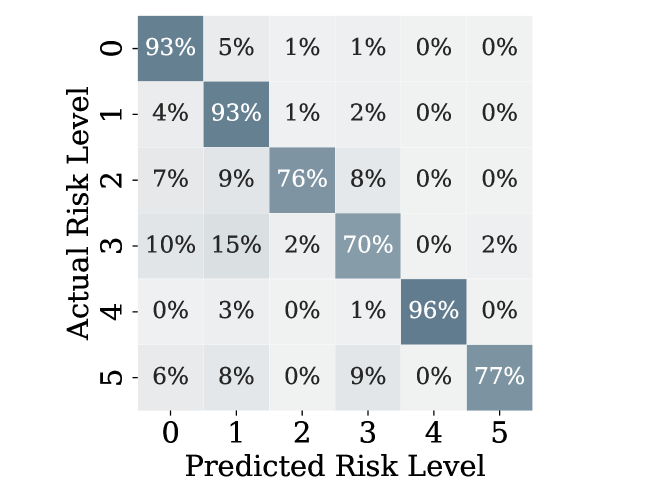
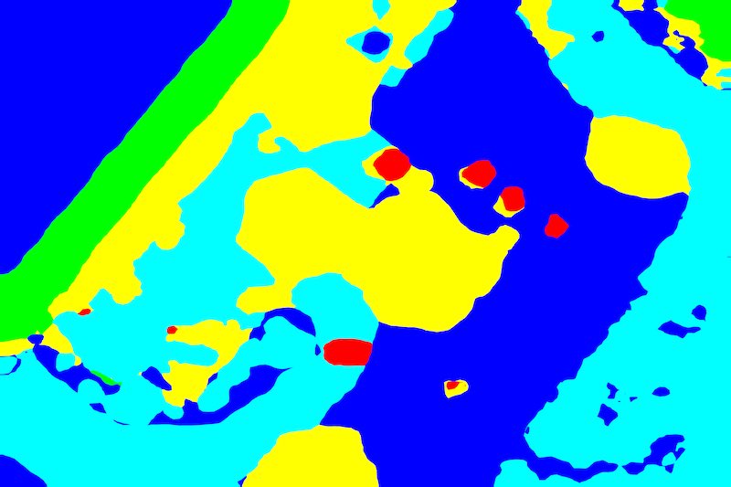
Fig. 5 shows a variety of examples from the test dataset, where an overall good performance is observed. One of the most notorious details from those is that aerial views from high altitude, high risk level classes are not very detailed, sometimes do not even appearing in the prediction, as can be shown in rows and . Aside from requiring more training, this is caused by the small scale of these classes en the image and, as previously mentioned, their low count against low risk classes. This produces the considerable number of false negatives. This might seem problematic, but in a real scenario it would be expected that while approaching land, the model would start identifying people as seen on . Again, this is a problem of generalization and could be addressed training the model with a larger dataset containing images taken from higher altitudes. In contrast, images closer to the ground have fewer classes, and predictions are more accurate. This is important because in a landing attempt, the UAV will descend start receiving more confident information to adjust the last maneuvers. Future work can consider the altitude to produce a confidence index so that the UAV will take appropriate action based on it.In general, this work show the huge potential of SS-based techniques to provide useful information to UAS to determine more confidently the best options to land in case of an emergency.
a)
b) 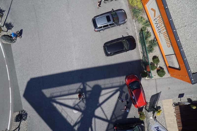

c) 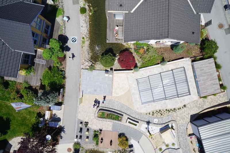
d) 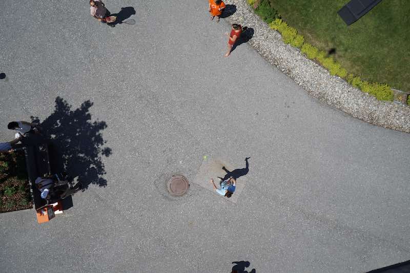

e) 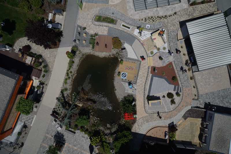
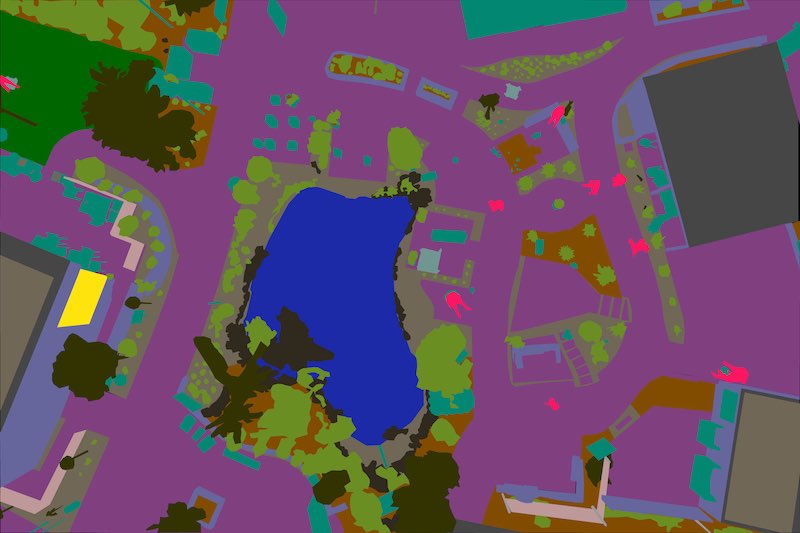
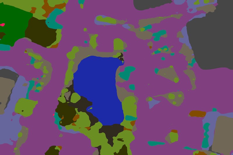
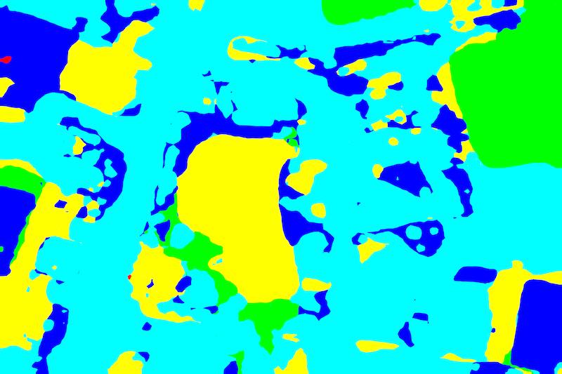
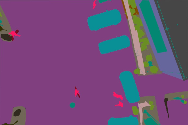
Fig. 6 show some extra examples of inference from the trained model, but from aerial pictures in different scenarios not contained on the original dataset. In this case, the uncontrolled and different scenarios of the pictures produce a variety of results. First, it can be seen that for test , the inferred results are quite good and very useful: cyclist are clearly find by the model and details of surroundings are well defined. Results could be this good because this picture is similar to the ones at the Semantic Drone Dataset. By contrast, other images show more important misclassifications that results in an incorrect risk level map. In the case at row , one car in the middle is identified as an AR-Marker, which puts it at very low risk. It also confuses an air exhaust as a person, although this does not cause any risk for the operation. These behaviors showcase the great complexity of the task of autonomous landing in real unstructured urban scenarios. The case in row also signals some non existent people, and dirt at the right of the image is defined as paved-area. Finally, example presents completely new classes not considered in the Semantic Drone Datasets, such as the train and its track. It can be seen that the model tries to categorize some features, as the train and its track as paved area and roof, which do not have the risk level that normally would be assigned to this objects. All of this only reinforces the need to train the model in a more extensive and diverse dataset, but even with errors, this proposal is able to provide useful information to preview the best areas for emergency AL.
a) 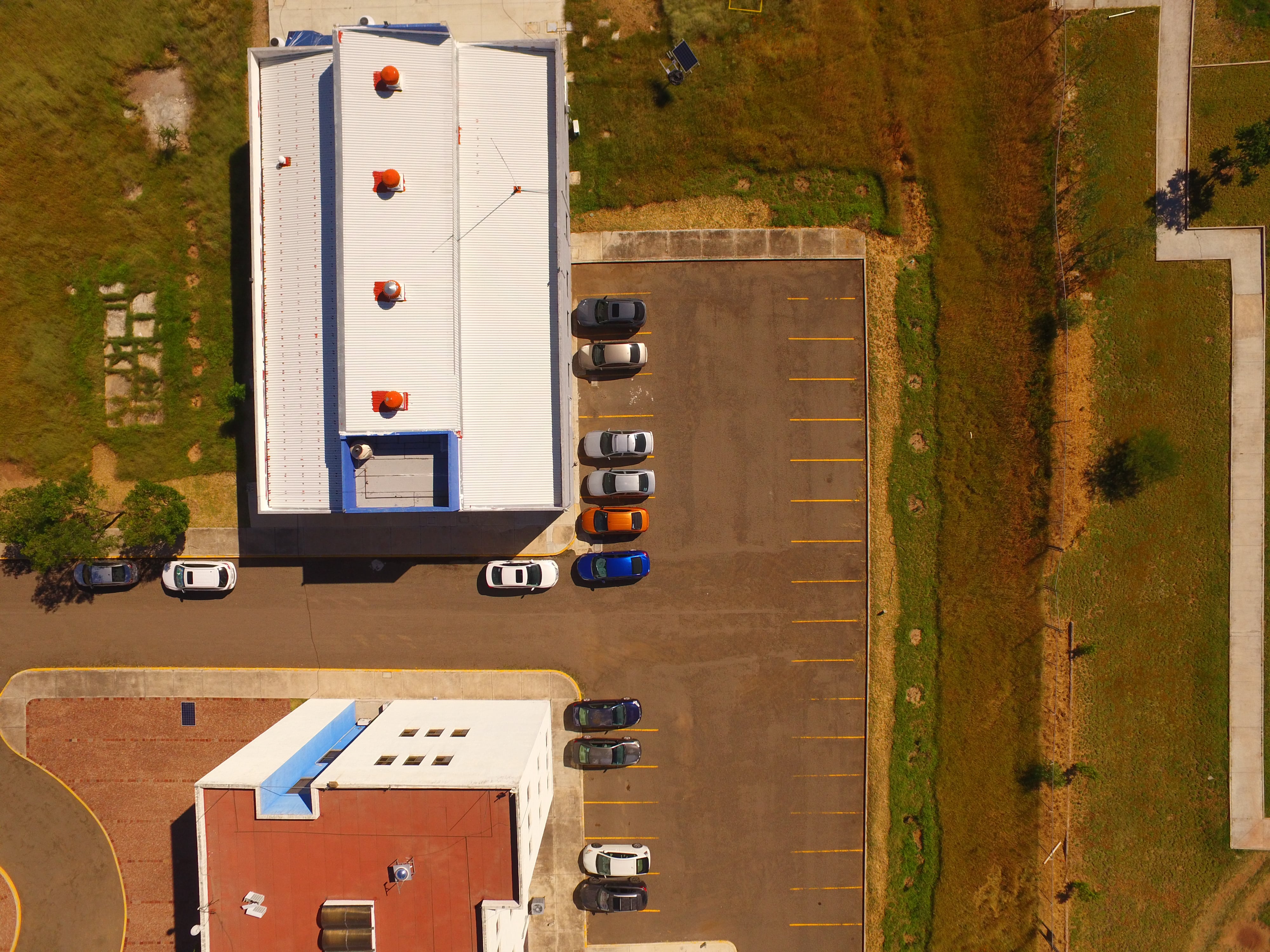


b) 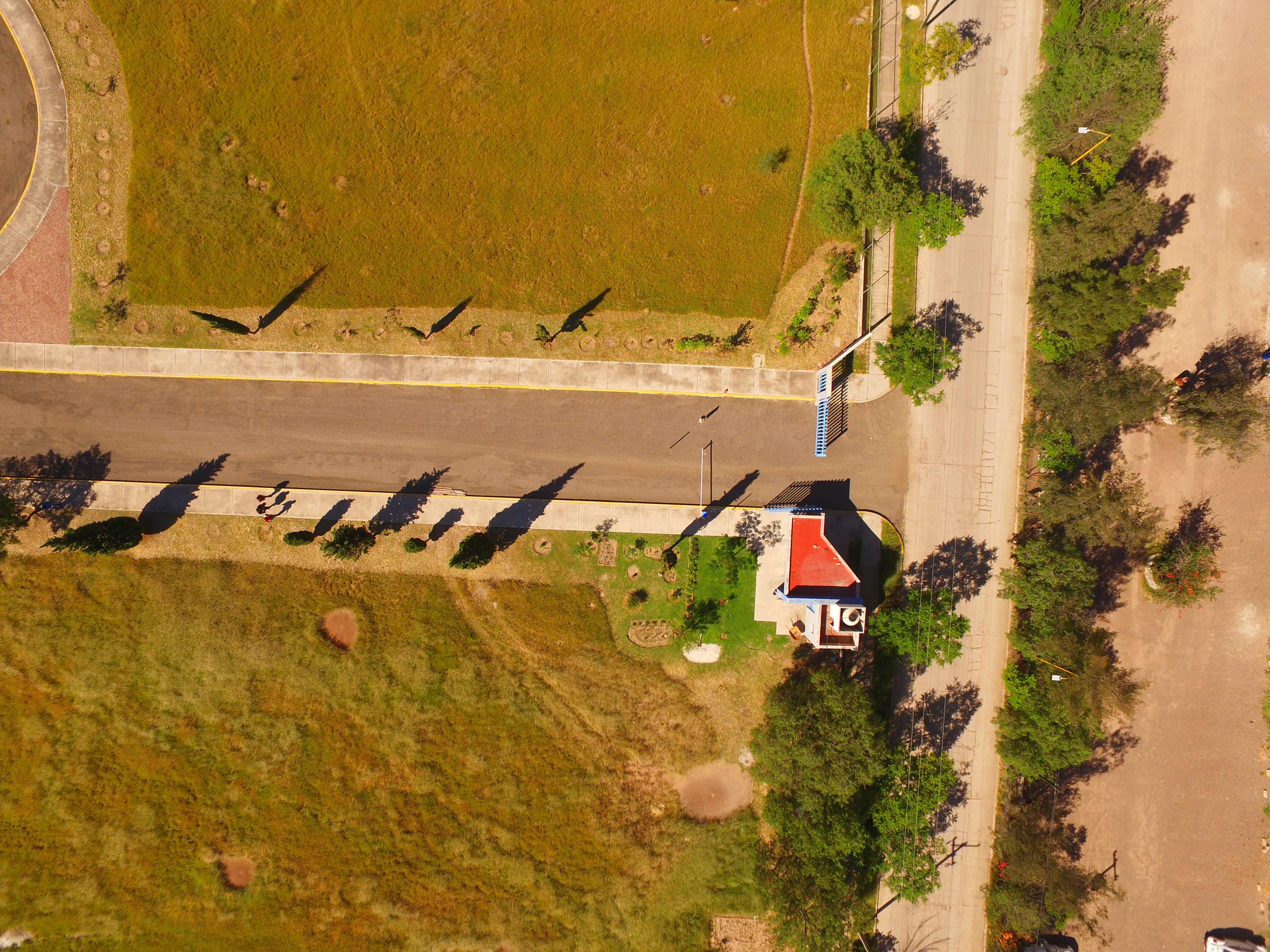

c) 


d) 


Those extra examples demonstrate that the model and the categorization of the classes is a viable tool for UAVs when requiring to land autonomously in their surroundings. Some issues with the generalization could be mainly solved by training in a more diverse dataset. There are still some interesting approaches using this method, but for now this work presents a good alternative to assess the risk on the current image of a UAS which can be used to select the best available Safe Landing Zone.
5 Conclusion
In this article, a semantic segmentation-based risk assessment strategy for autonomous landing in complex unstructured urban scenarios was proposed. First, a state-of-the-art visual transformer network was chosen and trained for semantic segmentation image input from a UAS. Then, six different risk levels are obtained from the semantic segmentation model output, which gives more certainty to find high risk areas to avoid in case of an autonomous landing.
The method presented in this work was evaluated along different case studies, and showcases the huge potential of using semantic segmentation and risk grouping to provide important contextual information to the UAV about the ground risk in its surroundings, useful for decision making, particularly in emergency landing situations.The work presented here adds robustness to the system in case of an emergency landing is needed, improving its SORA score and opening the way for applications in complex urban environments of being authorized.
Future work includes expanding the training dataset in order to capture more diversity of urban scenarios, camera angles, class variability and more height. Also, it is of interest to use the risk assessment information to choose a landing spot using some formal decision process that accounts for uncertainty and other variables. Finally, it is planned to validate each module of the proposal in real settings, running the algorithms embedded in a UAV and finding a Safe Landing Zone.
5.0.1 Acknowledgements
This work was supported by the Mexican National Council of Humanities, Science and Technology (Conahcyt), and the U.S. Office of Naval Research (ONR).
5.0.2 \discintname
The authors have no competing interests to declare that are relevant to the content of this article.
References
- [1] Abualigah, L., Diabat, A., Sumari, P., Gandomi, A.H.: Applications, deployments, and integration of internet of drones (iod): A review. IEEE Sensors Journal 21(22), 25532–25546 (2021). https://doi.org/10.1109/JSEN.2021.3114266
- [2] Administration, F.A.: Code of federal regulations part 107 small unmanned aircraft systems (6 2016), https://www.ecfr.gov/current/title-14/chapter-I/subchapter-F/part-107, u.S. Departament of Transportation
- [3] Administration, F.A.: Unmanned aircraft systems (uas) (9 2021), https://www.faa.gov/uas/, u.S. Departament of Transportation
- [4] Agency, E.U.A.S.: Unmanned aircraft systems (uas) (5 2019), https://www.easa.europa.eu/en/regulations/unmanned-aircraft-systems-uas, revision from April 2024
- [5] Chan, A.B., Liang, Z.S.J., Vasconcelos, N.: Privacy preserving crowd monitoring: Counting people without people models or tracking. In: 2008 IEEE Conference on Computer Vision and Pattern Recognition (6 2008). https://doi.org/10.1109/cvpr.2008.4587569, https://doi.org/10.1109/cvpr.2008.4587569
- [6] Chen, L., Xiao, Y., Yuan, X., Zhang, Y., Zhu, J.: Robust autonomous landing of uavs in non-cooperative environments based on comprehensive terrain understanding. Science China Information Sciences 65(11), 212202 (2022)
- [7] Garcia-Pardo, P.J., Sukhatme, G.S., Montgomery, J.F.: Towards vision-based safe landing for an autonomous helicopter. Robotics and Autonomous Systems 38(1), 19–29 (2002)
- [8] Gonzalez-Trejo, J., Mercado-Ravell, D.: Dense crowds detection and surveillance with drones using density maps. In: 2020 International Conference on Unmanned Aircraft Systems (ICUAS) (9 2020). https://doi.org/10.1109/icuas48674.2020.9213886, https://doi.org/10.1109/icuas48674.2020.9213886
- [9] Gonzalez-Trejo, J.A., Mercado-Ravell, D.A.: Lightweight density map architecture for uavs safe landing in crowded areas. Journal of Intelligent & Robotic Systems 102(1), 7 (2021). https://doi.org/10.1007/s10846-021-01380-8, https://doi.org/10.1007/s10846-021-01380-8
- [10] Gonzalez-Trejo, J.A., Mercado-Ravell, D.A.: Dense crowds detection and counting with a lightweight architecture (2020)
- [11] González-Trejo, J., Mercado-Ravell, D., Becerra, I., Murrieta-Cid, R.: On the visual-based safe landing of uavs in populated areas: A crucial aspect for urban deployment. IEEE Robotics and Automation Letters 6(4), 7901–7908 (2021). https://doi.org/10.1109/LRA.2021.3101861
- [12] Johnson, A., Montgomery, J., Matthies, L.: Vision guided landing of an autonomous helicopter in hazardous terrain. In: Proceedings of the 2005 IEEE International Conference on Robotics and Automation (2005). https://doi.org/10.1109/robot.2005.1570727, https://doi.org/10.1109/robot.2005.1570727
- [13] Kendoul, F., Fantoni, I., Lozano, R.: Adaptive vision-based controller for small rotorcraft uavs control and guidance. IFAC Proceedings Volumes 41(2), 797–802 (2008)
- [14] Krizhevsky, A., Sutskever, I., Hinton, G.E.: Imagenet Classification with Deep Convolutional Neural Networks. In: Pereira, F., Burges, C., Bottou, L., Weinberger, K. (eds.) Advances in Neural Information Processing Systems. vol. 25. Curran Associates, Inc. (2012), https://proceedings.neurips.cc/paper_files/paper/2012/file/c399862d3b9d6b76c8436e924a68c45b-Paper.pdf
- [15] Li, Y., Zhang, X., Chen, D.: Csrnet: Dilated convolutional neural networks for understanding the highly congested scenes (2018)
- [16] Liu, W., Lis, K., Salzmann, M., Fua, P.: Geometric and physical constraints for drone-based head plane crowd density estimation. In: 2019 IEEE/RSJ International Conference on Intelligent Robots and Systems (IROS) (11 2019). https://doi.org/10.1109/iros40897.2019.8967852, https://doi.org/10.1109/iros40897.2019.896785
- [17] Rabaud, V., Belongie, S.: Counting crowded moving objects. In: 2006 IEEE computer society conference on computer vision and pattern recognition (CVPR’06). vol. 1, pp. 705–711. IEEE (2006)
- [18] Rogge, N.: Fine-tune a semantic segmentation model with a custom dataset (Mar 2022), https://huggingface.co/blog/fine-tune-segformer
- [19] Ronneberger, O., Fischer, P., Brox, T.: U-net: Convolutional networks for biomedical image segmentation. In: International Conference on Medical image computing and computer-assisted intervention. pp. 234–241. Springer (2015)
- [20] Saripalli, S., Montgomery, J., Sukhatme, G.: Vision-based autonomous landing of an unmanned aerial vehicle. In: Proceedings 2002 IEEE International Conference on Robotics and Automation (Cat. No.02CH37292) (- 2002). https://doi.org/10.1109/robot.2002.1013656, https://doi.org/10.1109/robot.2002.1013656
- [21] Symeonidis, C., Kakaletsis, E., Mademlis, I., Nikolaidis, N., Tefas, A., Pitas, I.: Vision-based uav safe landing exploiting lightweight deep neural networks. In: Proceedings of the 2021 4th International Conference on Image and Graphics Processing. pp. 13–19 (2021)
- [22] of Technology, G.U.: Semantic drone dataset (2019), http://dronedataset.icg.tugraz.at/, accessed on February 8, 2024
- [23] Teixeira, K., Miguel, G., Silva, H.S., Madeiro, F.: A survey on applications of unmanned aerial vehicles using machine learning. IEEE Access 11, 117582–117621 (2023). https://doi.org/10.1109/ACCESS.2023.3326101
- [24] Theodore, C., Shelden, S., Rowley, D., Dai, W., Takahashi, M., McLain, T.: Full mission simulation of a rotorcraft unmanned aerial vehicle for landing in a non-cooperative environment. In: ANNUAL FORUM PROCEEDINGS-AMERICAN HELICOPTER SOCIETY. vol. 61, p. 1683. AMERICAN HELICOPTER SOCIETY, INC (2005)
- [25] Tovanche-Picon, H., Gonzalez-Trejo, J., Flores-Abad, A., Mercado-Ravell, D.: Visual-based safe landing for uavs in populated areas: Real-time validation in virtual environments (2022), https://arxiv.org/abs/2203.13792
- [26] Tzelepi, M., Tefas, A.: Human crowd detection for drone flight safety using convolutional neural networks. In: 2017 25th European Signal Processing Conference (EUSIPCO). pp. 743–747 (Aug 2017). https://doi.org/10.23919/EUSIPCO.2017.8081306
- [27] Tzelepi, M., Tefas, A.: Graph embedded convolutional neural networks in human crowd detection for drone flight safety. IEEE Transactions on Emerging Topics in Computational Intelligence 5(2), 191–204 (2019)
- [28] Tzelepi, M., Tefas, A.: Graph embedded convolutional neural networks in human crowd detection for drone flight safety. IEEE Transactions on Emerging Topics in Computational Intelligence pp. 1–14 (2019). https://doi.org/10.1109/tetci.2019.2897815, https://doi.org/10.1109/tetci.2019.2897815
- [29] for Rulemaking of Unmanned Systems, J.A.: Specific operations risk assessment (sora) (Jan 2019), https://www.easa.europa.eu/en/domains/civil-drones-rpas/specific-category-civil-drones/specific-operations-risk-assessment-sora
- [30] Vaswani, A., Shazeer, N., Parmar, N., Uszkoreit, J., Jones, L., Gomez, A.N., Kaiser, Ł., Polosukhin, I.: Attention is all you need. Advances in neural information processing systems 30 (2017)
- [31] Xie, E., Wang, W., Yu, Z., Anandkumar, A., Alvarez, J.M., Luo, P.: Segformer: Simple and efficient design for semantic segmentation with transformers. Advances in Neural Information Processing Systems 34, 12077–12090 (2021)