Autonomous Navigation and Collision Avoidance for Mobile Robots: Classification and Review
Abstract
This paper introduces a novel classification for Autonomous Mobile Robots (AMRs), into three phases and five steps, focusing on autonomous collision-free navigation. Additionally, it presents the main methods and widely accepted technologies for each phase of the proposed classification. The purpose of this classification is to facilitate understanding and establish connections between the independent input variables of the system (hardware, software) and autonomous navigation. By analyzing well-established technologies in terms of sensors and methods used for autonomous navigation, this paper aims to provide a foundation of knowledge that can be applied in future projects of mobile robots.
Index Terms:
Autonomous Mobile Robots, Navigation, Sensors, Methods, Obstacle AvoidanceI Introduction
Autonomous Mobile Robots (AMRs) are becoming increasingly essential in various sectors. They assist humans in performing complex, hazardous, or repetitive tasks. Initially created to improve productivity and safety in industrial settings, their scope has significantly broadened. From initially focusing on path planning for industrial manipulators [1], AMRs now use advanced algorithms to navigate without collisions. This expansion has allowed them to operate in diverse and dynamic environments beyond just industrial settings [2, 3].
Despite considerable advancements, existing navigational strategies for Autonomous Mobile Robots (AMRs) often remain focused on specific domains: terrestrial, aerial, and aquatic. These strategies typically adopt layered approaches from perception to control, each tailored to distinct operational environments such as industrial settings [4], uneven terrains [5, 6], and underwater exploration [7, 8]. All these applications suggest a lack of a unified framework that can seamlessly be integrated across all domains, a gap this paper aims to address. By adopting modular packages, the proposed classification enhances the reusability and interoperability of components, facilitating easier integration across all domains of autonomous navigation [9, 10].
This paper introduces a new, comprehensive classification system aimed at streamlining the various aspects of autonomous navigation. The system acts as a fundamental framework, organizing the intricate relationships between phases, modules, and layers. It improves the comprehension and execution of autonomous navigation strategies, offering clear insights, and ultimately offering a complete set of tools for practitioners to choose the best solution for a wide range of operational scenarios.
The paper is organized as follows: Section II presents the methodology and the process undertaken to develop our classification and review of components and technologies. Section III outlines the unified classification. Section IV discusses technological integrations and their applicability within various domains. Section V explores potential future directions and innovations, and Section VI concludes with key findings and implications for future research.
II Methodology for Literature Review
This study applied a systematic literature review approach to summarize the existing classifications and technologies in the field of autonomous navigation. In parallel with the analytical rigor demonstrated by [11] in the autonomous vehicle domain. We aim to systematically identify and categorize significant contributions across the spectrum of autonomous mobile robots.
The objectives were to identify key classifications of autonomous navigation and analyze the integration of hardware, software, and the robot-environment dynamic.
The research criteria focused on:
-
•
Peer-reviewed papers that provided foundational insights and demonstrated long-term impact in the field.
-
•
Clear frameworks for autonomous navigation, aiming to bridge foundational theories with contemporary advancements.
-
•
Practical applications of technologies with significant developments in autonomous navigation.
Searches were conducted across major databases such as IEEE Xplore, ScienceDirect, Web of Knowledge, and SpringerLink using keywords like ”autonomous navigation,” ”robot classification,” and ”obstacle avoidance.” This strategic approach facilitated the inclusion of seminal, consolidated, and cutting-edge contributions.
This literature review allows to propose a novel classification intended to bridge existing gaps and facilitate future research in the field of autonomous navigation.
III A Unified Classification for Diverse Autonomous Navigation Applications
This study has synthesized techniques, methodologies, and technologies for autonomous navigation, focusing on the dynamic interaction between hardware, software, and the robot environment. Based on this synthesis, we propose a unique classification system comprising three layers and five interconnected phases for autonomous navigation. The details of this classification system can be found on Figure 1.
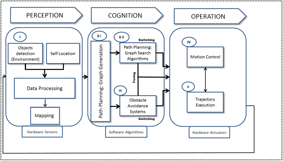
This classification interconnects the layers and phases as follows:
-
1.
Layer 1 - Perception
-
(a)
Phase I: Environment Perception, Self Location, Data Processing, and Mapping.
-
(a)
-
2.
Layer 2 - Cognition
-
(a)
Phase II: Path Planning, including Graph Construction and Graph Search.
-
(b)
Phase III Obstacle Avoidance and Trap landscape.
-
(a)
-
3.
Layer 3 - Operation
-
(a)
Phase IV Motion control,
-
(b)
Phase V Path Execution
-
(a)
The phases are not isolated but interconnected, covering the perception, cognition, and operation layers of mobile robotics. For instance, in the perception layer, mapping is integrated with data processing to generate a high-level environment representation, which is then used in the cognition layer for path planning and obstacle avoidance. This pre-map is then refined in the cognition layer to incorporate detailed terrain characteristics and navigability information. In the cognition layer, adaptive behavior is facilitated by integrating a Graph Search Algorithm with a Collision Avoidance System (CAS). This integration optimizes path planning to work in harmony with motion control, ultimately leading to the execution of a seamless trajectory.
III-A Phase I Environment Perception, Self Location, and Data Processing.
To initiate autonomous navigation, the robot must recognize its surrounding environment. This involves using different sensors to collect data, which is then processed to create an initial pre-map. Mapping algorithms like occupancy grid mapping [12], SLAM [2], and topological mapping generate this high-level representation of the environment. The pre-map distinguishes navigable and non-navigable areas and, plays a crucial role in subsequent stages, enabling the robot to determine its current location and plan a path to reach its destination.
Since autonomous robots rely on multiple sensors to perceive their environment, it is important to use filtering techniques to merge and refine collected data from these sensors.
Table I shows well-established sensors, while table II shows the most common filters used for data acquisition in environment perception, self-location, data processing, and mapping.
| Sensors | Reference |
| Geo-referencing Systems | |
| Inertial Navigation System (INS): IMU, Gyroscope, Compass, Altimeter | [13, 2] |
| Attitude and Heading Reference System (AHRS): MEMS Gyroscopes, Accelerometers, Magnetometers. | [14, 15] |
| Self Location Apparatus (for Dead Reckoning estimation) | |
| Odometer, Encoder | [16, 17, 18, 19, 20] |
| Optical Encoder | [21] |
| Ultrasonic Sensor | [22] |
| Eletromagnetic Waves Based Devices | |
| Radar | [23, 14, 15] |
| Ground Penetrating Radar (GPR) | [13, 14, 24, 25] |
| Global Positioning System (GPS) GPS and/or DGPS | [23, 16, 13, 15, 21, 26, 10] |
| Cooperative Location Sharing Devices | |
| Automatic dependent surveillance-broadcast (ADS-B), Zigbee, Wireless. | [16, 19] |
| PetriNet Model | [21] |
| Ground beacons based Position Locators Apparatus | |
| Radio Frequency Identification (RFID) | [27, 28] |
| Bluetooth wireless | [18] |
| Laser Rangefinders (light waves propagation) | |
| LiDAR | [23, 13, 16, 14, 15, 17, 29, 19, 26, 21, 4, 30] |
| Infrared Sensor | [21, 31] |
| Camera Visual Sensors | |
| Kinect (Depth), RGB Camera | [23, 13, 16, 32, 33, 15, 18, 26, 4, 30][29] |
| Filters | Reference |
| Multi Sensor Fusion based Filters | |
| Kalman Filter | [23, 16] |
| Extended Kalman Filter (EKF) | [29, 4] |
| Vision System Filters | |
| High Dynamic Range (HDR) Algorithms | [33] |
| Gaussian-based filters | [34, 9] |
| Bayesian-based filters | [28, 22] |
This paper does not explore sensor data processing libraries and localization methods. However, it is important to mention that established tools such as YOLO and OpenCV are widely used for detection and localization in the robotics Perception layer [35]. Visual SLAM algorithms [36, 37] and localization methods like Iterative Closest Point (ICP) [5] and Normal Distributions Transform (NDT) [35] scan matching are also crucial in this layer. Segmentation techniques, utilizing Gaussian-based models [34], further, enhance localization and visual navigation by accurately classifying navigable paths and reducing spatial requirements for map storage.
III-B Phase IIA - Path Planning: Graph Construction
Once the perception processing unit in the perception layer extracts meaningful data and creates an initial pre-map using sensor data, the cognition layer refines it. Techniques like surfel-based mapping [30], Delaunay triangulation, and visibility constraints refine the map into a dense 3D representation [37], ensuring accuracy and navigability. This detailed mapping allows the cognition layer to plan precise paths. Table III presents usual map-building techniques for autonomous navigation.”
| Method | Reference |
| Graph Search Maps | |
| Voronoi Diagram | [38, 39] |
| Exact Cell Decomposition | [9, 39] |
| Height Segmented Map | [40] |
| Surfel-Based Map | [30] |
| Approximate Cell Decompositon | [23, 13, 14, 17, 39] |
| Lattice Graph | [41, 42, 43, 44] |
| Potential Field Maps | |
| Extended Potential Field Approach | [45, 46, 39] |
| Others Methods of Map Building | |
| Genetic Algorithm (GA) | [16, 39] |
| CNN Feature Map | [47] |
| Spatio-Temporal Voxel Layer (STVL) | [4] |
| Dense 3D Mapping | [37, 6, 5] |
As shown in Table III, the Graph Search technique is frequently applied in AMRs, particularly within structured environments like indoor settings. This method effectively utilizes predefined grid or mesh maps for precise navigation.
III-C Phase IIB - Path Planning: Graph Search Algorithms
Once the robot knows its position, environment features, and target, it starts path planning. Roboticists focus on two main parameters in this phase, as noted in [48]:
-
•
completeness: The ability to find a solution within a finite time.
-
•
optimality: The ability to compute the most efficient path considering time, energy, or distance. Various strategies for achieving these goals are extensively discussed [39].
Table IV presents well-established path-planning algorithms that have been applied in recent works on autonomous navigation.
| Trajectory Generation | Reference |
| Deterministic Graph Search | |
| Breadth-First Search (BFS) | [9, 49, 35] |
| Depth-First Search (DFS) | [9] |
| Dijkstra’s Algorithm | [50, 51, 35] |
| A* Algorithm | [14, 40, 38, 35] |
| D*Algorithm | [17, 43] |
| Smac Planner | [52] |
| Randomized Graph Search | |
| Rapidly Exploring Random Tree (RRT) | [53, 5, 35] |
| Spline Sample RRT* | [26] |
| Probabilistic Roadmap | [18, 5] |
| OMPL and SBO Planners | [5] |
| Derived Algorithms from the previous graph search methods | |
| Potential Field based Algorithms | [13, 54, 55] |
| Artificial Potential Field (APF) | [19, 56] |
| Spline Path Planning | [29] |
| Fuzzy Heuristic Search | [7, 31] |
| Firefly Algorithm (FA) | [21] |
| High Autonomous Driving (HAD) Algorithms | [57] |
| Smoothed A* Algorithm | [58] |
For path planning, autonomous vehicles mainly use the A* algorithm and its variants. Traditional methods like BFS and DFS are less preferred due to their inefficiency in optimizing paths. Instead, roboticists develop customized heuristic methods that balance path optimality and computational costs, addressing processing power and decision time constraints[59].
III-D Phase III: Obstacle Avoidance and Trap Landscapes
During autonomous operations, mobile robots must navigate around obstacles. If not programmed in the initial phases, collision avoidance systems (CAS) become crucial. These systems are adapted to the robot’s operational environment and kinodynamics, ensuring safe maneuverability. Table V details established CAS algorithms, reflecting their varied response times, safety distances, and specific functionalities.
| STRATEGIES CASs | References |
| Traditional Algorithms | |
| Bug Algorithms | [60, 61, 62, 31] |
| Vector Field Histogram (VFH) | [13, 45] |
| VFH+ | [63] |
| VFH* | [64] |
| The Bubble Band Technique | [65, 14, 26] |
| Elastic Band Concept | [66] |
| Curvature Velocities Techniques (CVM) | [47, 67] |
| Dynamic Windows Approaches | [23, 68, 69, 70] |
| The Schlegel Approach | [71] |
| Nearness Diagram | [72, 73, 17] |
| Virtual Force Field (VFF) Methods | |
| Gradient Methods | [56, 74, 31] |
| Bacterial Potential Field | [54] |
| Genetic based Algorithms | |
| Biological Approach | [75] |
| Bioinspired Neural Network Algorithm | [76, 31] |
| Hybrid VFF-Genetic Algorithms | |
| Evolutionary Behaviour based on Genetic Programming | [55] |
| Geometrical Methods | |
| Boundary Following | [31] |
| Collision Cone | [18] |
| Higher Geometry Maze Routing Algorithm | [49] |
| Fuzzy / Neurofuzzy Relational Products | [77] |
| Anti-target Approach Laws | |
| Cone’s Geometry-based Calculated Rule | [78] |
Collision Avoidance Systems (CAS) play a vital role in ensuring the safe and effective operation of mobile robots in dynamic environments. By integrating these systems, robots are equipped to dynamically navigate through complex terrains, thereby enhancing their reliability and operational scope for real-world applications.
III-E Phase IV: Motion Control And Robot Relocation
To control the movement, speed, position, and orientation of the AMR, various controllers are integrated into the robot, addressing both hardware and software requirements. Vehicles face unique constraints and require specific accuracy and response times due to differing maneuverability capabilities and variable environments. A range of controllers have been developed to meet these needs, as shown in Table VI.
| Controllers | References |
| Control-Theory Based Controllers | |
| Nonlinear Controllers | |
| Time Elastic Band | [4] |
| Nonlinear Optimal SDRE | [56] |
| Pure Pursuit | [53, 79, 80] |
| Linear Controllers | |
| Lane Detection and Sliding Mode | [81, 31] |
| PID (Pose / Velocity) | [13, 14, 79] |
| Model Predictive Control (MPC) | [31, 6] |
| Hybrid Controllers | |
| PID (Pose / Velocity) | [81] |
| Model Predictive Path Integral Control (MPPI) | [82] |
| Behaviour Based Controllers | |
| Machine Learning | |
| Matlab/hardware Loop | [57] |
| Receding Horizon (CNN) | [47] |
| Relocation Techniques And Others Sorts of Controllers | |
| SLAM | [23] |
| Hybrid | [55] |
From Table VI, it is evident that complex vehicle dynamics and rapidly changing environments necessitate the use of multiple controller types. For example, [53] and [79] combined nonlinear controllers with PID controllers to enhance steering and speed regulation. Modern approaches increasingly incorporate nonlinear controllers to address complex differential equations more effectively. Additionally, the use of cooperative predictive controllers has become prevalent, optimizing robot relocation and enhancing motion control efficiency [23].
III-F Phase V: Trajectory Execution
AMRs are equipped with specialized hardware to execute planned routes. Some adhere to predefined trajectories (offline trajectory execution), while others use episodic planning to dynamically integrate planning and execution using sensor data [9]. Additionally, AMRs may include real-time replanning modules within the operation layer, eliminating the temporal gap between planning and execution. Behavior trees [83] coordinate diverse planning and execution modules to manage dynamic conditions effectively. This approach increases flexibility, enabling AMRs to adapt to varying environments and operational demands. The distinction between offline and online path planning underscores the necessity for dynamic response capabilities in online scenarios, where unpredictable environments pose significant computational challenges [49]. Table VII highlights commonly used methods and algorithms for trajectory execution.
| Method/Algorithm | References |
|---|---|
| Offline Planning (Dead Reckoning) | [13, 84, 54, 25] |
| Episodic Planning (Deferred Planning) | [20, 85, 86, 14, 87, 55] |
| Integrated Planning and Execution (Real Time Replanning) | [57, 47, 42, 43, 44, 40, 15, 53, 31, 21, 26, 83] |
| Hybrid Layers Switching | [8, 50] |
IV Discussion
The proposed classification of autonomous navigation and the discussion of both well-established and recent techniques and technologies not only contribute to academic understanding but also provide a practical guide for the design and implementation of future mobile robots. This framework also facilitates learning about the various algorithms, components, and sensors that compose autonomous navigation, ranging from perception to operation.
V Tendencies
Recent advancements in Autonomous Mobile Robots (AMRs) underscore trends that enhance their operational capabilities:
-
•
Enhanced Communication Technologies: Introduction of 5G technology significantly improves real-time data sharing among AMRs, crucial for industrial automation.
-
•
Evolution of Navigation Algorithms: The adoption of evolutionary algorithms and neural networks bolsters real-time decision-making in AMRs.
-
•
Artificial Intelligence in Cognition: Integration of deep learning enhances path prediction and decision-making, facilitating advanced cognitive functions.
-
•
Advanced Sensor Fusion and Data Processing: Enhanced filtering techniques and new algorithms improve environmental perception and motion planning under challenging conditions.
-
•
Sensor Diversity and Data Redundancy: The use of diverse sensors and advanced probabilistic filters increases data reliability, optimizing tasks like SLAM.
-
•
Nonlinear Filtering Techniques: Nonlinear filters are critical for accurately processing the complex dynamics of AMRs, enhancing motion control and trajectory prediction.
-
•
Adaptability Across Environments: AMRs have advanced in operating across varied environments: terrestrial, aerial, and aquatic, broadening their applications to include disaster response and environmental monitoring.
These innovations highlight the dynamic evolution of AMR technology, where flexibility and improved communication are key drivers of enhanced robotic navigation.
VI Conclusion
This paper presented a novel classification system for the domain of autonomous mobile robots (AMRs), aiming to refine the interconnection between diverse technologies for autonomous navigation. By exploring various techniques (such as methodologies, methods, and strategies) and technologies (including sensors, tools and filters) readers can develop deeper understanding of the different phases of autonomous navigation and they can make informed choices of well-established tools for designing mobile robots.
Acknowledgment
This research was financed in part by the Coordenação de Aperfeiçoamento de Pessoal de Nível Superior – Brasil (CAPES) – Finance Code 001, and supported by Fundação de Amparo à Pesquisa e Inovação do Estado de Santa Catarina.
References
- [1] O. Khatib, “Real-time obstacle avoidance for manipulators and mobile robots,” Int. J. Robot., vol. 5, no. 1, pp. 90–98, 1986.
- [2] P. K. Panigrahi and S. K. Bisoy, “Localization strategies for autonomous mobile robots: A review,” J. King Saud Univ., Comp. & Info. Sci., vol. 34, no. 8, pp. 6019–6039, 2022.
- [3] J. R. Sánchez-Ibáñez, C. J. Pérez-del Pulgar, and A. García-Cerezo, “Path planning for autonomous mobile robots: A review,” Sensors, vol. 21, no. 23, p. 7898, 2021.
- [4] S. Macenski, F. Martin, R. White, and J. Ginés Clavero, “The marathon 2: A navigation system,” in 2020 IEEE/RSJ IRO), 2020.
- [5] F. Atas, L. Grimstad, and G. Cielniak, “Evaluation of sampling-based optimizing planners for outdoor robot navigation,” arXiv preprint arXiv:2103.13666, 2021.
- [6] F. Atas, G. Cielniak, and L. Grimstad, “Navigating in 3d uneven environments through supervoxels and nonlinear mpc,” in 2023 ECMR. IEEE, 2023, pp. 1–8.
- [7] Y.-i. Lee, Y.-G. Kim, and L. J. Kohout, “An intelligent collision avoidance system for auvs using fuzzy relational products,” Inf. Sci, vol. 158, pp. 209–232, 2004.
- [8] G. Antonelli, S. Chiaverini, R. Finotello, and R. Schiavon, “Real-time path planning and obstacle avoidance for rais: an autonomous underwater vehicle,” IEEE J Ocean Eng, vol. 26, no. 2, pp. 216–227, 2001.
- [9] R. Siegwart, I. R. Nourbakhsh, D. Scaramuzza, and R. C. Arkin, Introduction to autonomous mobile robots, 2011.
- [10] S. S. H. Hajjaj and K. S. M. Sahari, “Bringing ros to agriculture automation: hardware abstraction of agriculture machinery,” Int. J. Appl. Eng. Res., vol. 12, no. 3, pp. 311–316, 2017.
- [11] L. Chen, Y. Li, C. Huang, B. Li, Y. Xing, D. Tian, L. Li, Z. Hu, X. Na, Z. Li et al., “Milestones in autonomous driving and intelligent vehicles: Survey of surveys,” IEEE Trans. Intell. Veh., vol. 8, no. 2, pp. 1046–1056, 2022.
- [12] J. Esenkanova, H. O. İlhan, and S. Yavuz, “Pre-mapping system with single laser sensor based on gmapping algorithm,” IJOEE, vol. 1, no. 2, pp. 97–101, 2013.
- [13] Y. He, C. Chen, C. Bu, and J. Han, “A polar rover for large-scale scientific surveys: design, implementation and field test results,” Int. J. Adv. Robot. Syst., vol. 12, no. 10, p. 145, 2015.
- [14] C. Urmson, J. Anhalt, D. Bartz, M. Clark, T. Galatali, A. Gutierrez, S. Harbaugh, J. Johnston, P. Koon, W. Messner et al., “A robust approach to high-speed navigation for unrehearsed desert terrain,” in The 2005 DARPA Grand Challenge. Springer, 2007, pp. 45–102.
- [15] S. Noh, “Decision-making framework for autonomous driving at road intersections: Safeguarding against collision, overly conservative behavior, and violation vehicles,” IEEE Trans. Ind. Electron, vol. 66, no. 4, pp. 3275–3286, 2019.
- [16] H. Li, M. Tsukada, F. Nashashibi, and M. Parent, “Multivehicle cooperative local mapping: A methodology based on occupancy grid map merging,” IEEE T-ITS, vol. 15, no. 5, pp. 2089–2100, 2014.
- [17] I. Iturrate, J. M. Antelis, A. Kubler, and J. Minguez, “A noninvasive brain-actuated wheelchair based on a p300 neurophysiological protocol and automated navigation,” IEEE Trans. Robot., vol. 25, no. 3, pp. 614–627, 2009.
- [18] J. Snape, J. Van Den Berg, S. J. Guy, and D. Manocha, “The hybrid reciprocal velocity obstacle,” IEEE Trans. Robot., vol. 27, no. 4, pp. 696–706, 2011.
- [19] H. Li and A. V. Savkin, “An algorithm for safe navigation of mobile robots by a sensor network in dynamic cluttered industrial environments,” Robot. Comput.-Integr. Manuf., vol. 54, pp. 65–82, 2018.
- [20] A. C. Schultz and W. Adams, “Continuous localization using evidence grids,” in Proceedings. 1998 ICRA (Cat. No. 98CH36146), vol. 4. IEEE, 1998, pp. 2833–2839.
- [21] B. Patle, A. Pandey, A. Jagadeesh, and D. Parhi, “Path planning in uncertain environment by using firefly algorithm,” Def. Technol., vol. 14, no. 6, pp. 691–701, 2018.
- [22] P. Yang, “Efficient particle filter algorithm for ultrasonic sensor-based 2d range-only simultaneous localisation and mapping application,” IET Wireless Sensor Systems, vol. 2, no. 4, pp. 394–401, 2012.
- [23] M. Aeberhard, S. Rauch, M. Bahram, G. Tanzmeister, J. Thomas, Y. Pilat, F. Homm, W. Huber, and N. Kaempchen, “Experience, results and lessons learned from automated driving on germany’s highways,” IEEE T-ITS, vol. 7, no. 1, pp. 42–57, 2015.
- [24] E. Trautmann, L. Ray, and J. Lever, “Development of an autonomous robot for ground penetrating radar surveys of polar ice,” in 2009 IEEE/RSJ IROS. IEEE, 2009, pp. 1685–1690.
- [25] L. Ray, A. Adolph, A. Morlock, B. Walker, M. Albert, J. H. Lever, and J. Dibb, “Autonomous rover for polar science support and remote sensing,” in 2014 IEEE IGARSS. IEEE, 2014, pp. 4101–4104.
- [26] S. Yoon, D. Lee, J. Jung, and D. H. Shim, “Spline-based rrt* using piecewise continuous collision-checking algorithm for car-like vehicles,” J. Intell. Robot. Syst., vol. 90, no. 3-4, pp. 537–549, 2018.
- [27] W. Gueaieb and M. S. Miah, “An intelligent mobile robot navigation technique using rfid technology,” IEEE T Instrum. Meas., vol. 57, no. 9, pp. 1908–1917, 2008.
- [28] J. Zhang, Y. Lyu, J. Patton, S. C. Periaswamy, and T. Roppel, “Bfvp: A probabilistic uhf rfid tag localization algorithm using bayesian filter and a variable power rfid model,” IEEE Trans. Ind. Electron., vol. 65, no. 10, pp. 8250–8259, 2018.
- [29] H. Xiao, Z. Li, C. Yang, W. Yuan, and L. Wang, “Rgb-d sensor-based visual target detection and tracking for an intelligent wheelchair robot in indoors environments,” IJCAS, vol. 13, no. 3, pp. 521–529, 2015.
- [30] F. Atas, G. Cielniak, and L. Grimstad, “Elevation state-space: Surfel-based navigation in uneven environments for mobile robots,” in 2022 IEEE/RSJ IROS. IEEE, 2022, pp. 5715–5721.
- [31] M. Hoy, A. S. Matveev, and A. V. Savkin, “Algorithms for collision-free navigation of mobile robots in complex cluttered environments: a survey,” Robotica, vol. 33, no. 3, pp. 463–497, 2015.
- [32] Z. Yan, J. Li, Y. Wu, and G. Zhang, “A real-time path planning algorithm for auv in unknown underwater environment based on combining pso and waypoint guidance,” Sensors, vol. 19, no. 1, p. 20, 2019.
- [33] N. Paul and C. Chung, “Application of hdr algorithms to solve direct sunlight problems when autonomous vehicles using machine vision systems are driving into sun,” Comput Ind., vol. 98, pp. 192–196, 2018.
- [34] P. De Cristóforis, M. Nitsche, T. Krajník, T. Pire, and M. Mejail, “Hybrid vision-based navigation for mobile robots in mixed indoor/outdoor environments,” Pattern Recognit. Lett., vol. 53, pp. 118–128, 2015.
- [35] M. V. L. d. Carvalho et al., “A review of ros based autonomous driving platforms to carry out automated driving functions,” 2022.
- [36] T. Pire, T. Fischer, J. Civera, P. De Cristóforis, and J. J. Berlles, “Stereo parallel tracking and mapping for robot localization,” in 2015 IEEE/RSJ IROS. IEEE, 2015, pp. 1373–1378.
- [37] Y. Ling and S. Shen, “Building maps for autonomous navigation using sparse visual slam features,” in 2017 IEEE/RSJ IROS. IEEE, 2017, pp. 1374–1381.
- [38] A. Sgorbissa and R. Zaccaria, “Planning and obstacle avoidance in mobile robotics,” Rob. Auton. Syst., vol. 60, no. 4, pp. 628–638, 2012.
- [39] A. Gasparetto, P. Boscariol, A. Lanzutti, and R. Vidoni, “Path planning and trajectory planning algorithms: A general overview,” Motion and Operation Planning of Robotic Systems: Background and Practical Approaches, pp. 3–27, 2015.
- [40] P. Karkowski, S. Oßwald, and M. Bennewitz, “Real-time footstep planning in 3d environments,” in 2016 IEEE-RAS 16th. IEEE, 2016, pp. 69–74.
- [41] M. Pivtoraiko, R. A. Knepper, and A. Kelly, “Differentially constrained mobile robot motion planning in state lattices,” J Field Robot., vol. 26, no. 3, pp. 308–333, 2009.
- [42] M. Rufli, D. Ferguson, and R. Siegwart, “Smooth path planning in constrained environments,” in 2009 ICRA. IEEE, 2009, pp. 3780–3785.
- [43] M. Rufli and R. Siegwart, “On the application of the d* search algorithm to time-based planning on lattice graphs,” in Proc. of The 4th ECMR. Eidgenössische Technische Hochschule Zürich, 2009, pp. 105–110.
- [44] D. Ferguson, T. M. Howard, and M. Likhachev, “Motion planning in urban environments: Part ii,” in 2008 IEEE/RSJ IROS. IEEE, 2008, pp. 1070–1076.
- [45] J. Borenstein and Y. Koren, “Real-time obstacle avoidance for fast mobile robots,” IEEE Trans. Syst. Man Cybern., vol. 19, no. 5, pp. 1179–1187, 1989.
- [46] M. Khatib and R. Chatila, “An extended potential field approach for mobile robot sensor-based motions,” in ICoIAS, 1995.
- [47] S. Yang, W. Wang, C. Liu, and W. Deng, “Scene understanding in deep learning-based end-to-end controllers for autonomous vehicles,” IEEE Trans. Syst. Man Cybern.: Systems, vol. 49, no. 1, pp. 53–63, 2019.
- [48] Z. Zeng, L. Lian, K. Sammut, F. He, Y. Tang, and A. Lammas, “A survey on path planning for persistent autonomy of autonomous underwater vehicles,” Ocean Eng., vol. 110, pp. 303–313, 2015.
- [49] P. Raja and S. Pugazhenthi, “Optimal path planning of mobile robots: A review,” Int. J. Phys. Sci., vol. 7, no. 9, pp. 1314–1320, 2012.
- [50] G. Casalino, A. Turetta, and E. Simetti, “A three-layered architecture for real time path planning and obstacle avoidance for surveillance usvs operating in harbour fields,” in Oceans 2009-Europe. IEEE, 2009, pp. 1–8.
- [51] H. Niu, Y. Lu, A. Savvaris, and A. Tsourdos, “Efficient path planning algorithms for unmanned surface vehicle,” IFAC-PapersOnLine, vol. 49, no. 23, pp. 121–126, 2016.
- [52] S. Macenski, M. Booker, and J. Wallace, “Open-source, cost-aware kinematically feasible planning for mobile and surface robotics,” arXiv preprint arXiv:2401.13078, 2024.
- [53] Y. Kuwata, J. Teo, G. Fiore, S. Karaman, E. Frazzoli, and J. P. How, “Real-time motion planning with applications to autonomous urban driving,” IEEE Trans. Control Syst. Technol., vol. 17, no. 5, pp. 1105–1118, 2009.
- [54] O. Montiel, U. Orozco-Rosas, and R. Sepúlveda, “Path planning for mobile robots using bacterial potential field for avoiding static and dynamic obstacles,” Expert Syst App., vol. 42, no. 12, pp. 5177–5191, 2015.
- [55] E. Clemente, M. Meza-Sánchez, E. Bugarin, and A. Y. Aguilar-Bustos, “Adaptive behaviors in autonomous navigation with collision avoidance and bounded velocity of an omnidirectional mobile robot,” J. Intell. Robot. Syst., vol. 92, no. 2, pp. 359–380, 2018.
- [56] S. M. H. Rostami, A. K. Sangaiah, J. Wang, and H.-j. Kim, “Real-time obstacle avoidance of mobile robots using state-dependent riccati equation approach,” EURASIP JIVP, vol. 2018, no. 1, p. 79, 2018.
- [57] M. Bahram, Z. Ghandeharioun, P. Zahn, M. Baur, W. Huber, and F. Busch, “Microscopic traffic simulation based evaluation of highly automated driving on highways,” in 17th ITSC. IEEE, 2014, pp. 1752–1757.
- [58] R. Song, Y. Liu, and R. Bucknall, “Smoothed a* algorithm for practical unmanned surface vehicle path planning,” Appl. Ocean Res., vol. 83, pp. 9–20, 2019.
- [59] J. L. G. Rosa, “Fundamentos da inteligência artificial,” 2011.
- [60] I. Kamon, E. Rivlin, and E. Rimon, “A new range-sensor based globally convergent navigation algorithm for mobile robots,” in Proceedings of ICRA, vol. 1. IEEE, 1996, pp. 429–435.
- [61] V. J. Lumelsky and A. A. Stepanov, “Path-planning strategies for a point mobile automaton moving amidst unknown obstacles of arbitrary shape,” Algorithmica, vol. 2, no. 1-4, pp. 403–430, 1987.
- [62] V. J. Lumelsky and T. Skewis, “Incorporating range sensing in the robot navigation function,” IEEE Trans. Syst. Man Cybern., vol. 20, no. 5, pp. 1058–1069, 1990.
- [63] I. Ulrich and J. Borenstein, “Vfh+: Reliable obstacle avoidance for fast mobile robots,” in Proceedings. 1998 ICRA (Cat. No. 98CH36146), vol. 2. IEEE, 1998, pp. 1572–1577.
- [64] ——, “Vfh/sup*: Local obstacle avoidance with look-ahead verification,” in Proceedings 2000 ICRA. Millennium Conference. ICRA. Symposia Proceedings (Cat. No. 00CH37065), vol. 3. IEEE, 2000, pp. 2505–2511.
- [65] M. Khatib, H. Jaouni, R. Chatila, and J.-P. Laumond, “Dynamic path modification for car-like nonholonomic mobile robots,” in Proc. - IEEE Int. Conf. Robot. Autom., vol. 4. IEEE, 1997, pp. 2920–2925.
- [66] S. Quinlan and O. Khatib, “Elastic bands: Connecting path planning and control,” in [1993] Proceedings ICRA. IEEE, 1993, pp. 802–807.
- [67] R. Simmons, “The curvature-velocity method for local obstacle avoidance,” in Proceedings of ICRA, vol. 4. IEEE, 1996, pp. 3375–3382.
- [68] J. Minguez, L. Montano, and O. Khatib, “Reactive collision avoidance for navigation with dynamic constraints,” in IEEE/RSJ IROS, vol. 1. IEEE, 2002, pp. 588–594.
- [69] D. Fox, W. Burgard, and S. Thrun, “The dynamic window approach to collision avoidance,” IEEE Robot Autom Mag., vol. 4, no. 1, pp. 23–33, 1997.
- [70] O. Brock and O. Khatib, “High-speed navigation using the global dynamic window approach,” in Proceedings 1999 ICRA (Cat. No. 99CH36288C), vol. 1. IEEE, 1999, pp. 341–346.
- [71] C. Schlegel, “Fast local obstacle avoidance under kinematic and dynamic constraints for a mobile robot,” in 1998 IEEE/RSJ IROS. PI-TPA (Cat. No. 98CH36190), vol. 1. IEEE, 1998, pp. 594–599.
- [72] J. Minguez and L. Montano, “Nearness diagram (nd) navigation: collision avoidance in troublesome scenarios,” IEEE T-RO, vol. 20, no. 1, pp. 45–59, 2004.
- [73] J. Mínguez and L. Montano, “Robot navigation in very complex, dense, and cluttered indoor/outdoor environments,” IFAC Proceedings Volumes, vol. 35, no. 1, pp. 397–402, 2002.
- [74] K. Konolige, “A gradient method for realtime robot control,” in Proceedings. 2000 IEEE/RSJ IROS 2000 (Cat. No. 00CH37113), vol. 1. IEEE, 2000, pp. 639–646.
- [75] C.-T. Chen, R. D. Quinn, and R. E. Ritzmann, “A crash avoidance system based upon the cockroach escape response circuit,” in Proc. - IEEE Int. Conf. Robot. Autom., vol. 3. IEEE, 1997, pp. 2007–2012.
- [76] X. Cao, D. Zhu, and S. X. Yang, “Multi-auv target search based on bioinspired neurodynamics model in 3-d underwater environments,” IEEE Trans. Neural Netw. Learn. Syst., vol. 27, no. 11, pp. 2364–2374, 2016.
- [77] C. S. Tzafestas and S. G. Tzafestas, “Recent algorithms for fuzzy and neurofuzzy path planning and navigation of autonomous mobile robots,” in 1999 ECC. IEEE, 1999, pp. 4736–4743.
- [78] A. Chakravarthy and D. Ghose, “Obstacle avoidance in a dynamic environment: A collision cone approach,” IEEE Trans. Syst. Man Cybern.-Part A: Systems and Humans, vol. 28, no. 5, pp. 562–574, 1998.
- [79] Y. Chen and J. J. Zhu, “Pure pursuit guidance for car-like ground vehicle trajectory tracking,” in ASME 2017 DSCC. American Society of Mechanical Engineers, 2017, pp. V002T21A015–V002T21A015.
- [80] S. Macenski, S. Singh, F. Martin, and J. Gines, “Regulated pure pursuit for robot path tracking,” Auton. Robots, 2023.
- [81] X. Zhang and X. Zhu, “Autonomous path tracking control of intelligent electric vehicles based on lane detection and optimal preview method,” Expert Syst App., vol. 121, pp. 38–48, 2019.
- [82] G. Williams, P. Drews, B. Goldfain, J. M. Rehg, and E. A. Theodorou, “Aggressive driving with model predictive path integral control,” in 2016 ICRA. IEEE, 2016, pp. 1433–1440.
- [83] S. Macenski, T. Moore, D. V. Lu, A. Merzlyakov, and M. Ferguson, “From the desks of ros maintainers: A survey of modern & capable mobile robotics algorithms in the robot operating system 2,” Rob. Auton. Syst., vol. 168, p. 104493, 2023.
- [84] I. R. Nourbakhsh, J. Bobenage, S. Grange, R. Lutz, R. Meyer, and A. Soto, “An affective mobile robot educator with a full-time job,” Artificial intelligence, vol. 114, no. 1-2, pp. 95–124, 1999.
- [85] R. Philippsen and R. Siegwart, “Smooth and efficient obstacle avoidance for a tour guide robot,” in Proceedings. 2003 ICRA, September 14-19, 2003, The Grand Hotel, Taipei, Taiwan, vol. 1. IEEE Operations Center, 2003, pp. 446–451.
- [86] K. O. Arras, J. Persson, N. Tomatis, and R. Siegwart, “Real-time obstacle avoidance for polygonal robots with a reduced dynamic window,” in Proceedings 2002 ICRA (Cat. No. 02CH37292), vol. 3. IEEE, 2002, pp. 3050–3055.
- [87] B. Li, W. Zhou, J. Sun, C.-Y. Wen, and C.-K. Chen, “Development of model predictive controller for a tail-sitter vtol uav in hover flight,” Sensors, vol. 18, no. 9, p. 2859, 2018.