MapEx: Indoor Structure Exploration with
Probabilistic Information Gain from Global Map Predictions
Abstract
Exploration is a critical challenge in robotics, centered on understanding unknown environments. In this work, we focus on robots exploring structured indoor environments which are often predictable and composed of repeating patterns. Most existing approaches, such as conventional frontier approaches, have difficulty leveraging the predictability and explore with simple heuristics such as ‘closest first’. Recent works use deep learning techniques to predict unknown regions of the map, using these predictions for information gain calculation. However, these approaches are often sensitive to the predicted map quality or do not reason over sensor coverage. To overcome these issues, our key insight is to jointly reason over what the robot can observe and its uncertainty to calculate probabilistic information gain. We introduce MapEx, a new exploration framework that uses predicted maps to form probabilistic sensor model for information gain estimation. MapEx generates multiple predicted maps based on observed information, and takes into consideration both the computed variances of predicted maps and estimated visible area to estimate the information gain of a given viewpoint. Experiments on the real-world KTH dataset showed on average 12.4% improvement than representative map-prediction based exploration and 25.4% improvement than nearest frontier approach.
I Introduction
Exploration is an important problem in robotics, with applications ranging from indoor search and rescue operations [1] to planetary missions [2] and outdoor monitoring [3]. The primary objective of exploration is to plan paths in an unknown environment to gain as much understanding of the environment within a limited budget. This objective could include building an accurate map [4], finding objects of interest [5], and finding traversable routes for robot teams [6]. The key challenge in exploration is choosing how to navigate for most information gain which requires reasoning over unobserved space due to uncertain environment geometry, occlusions, sensor range limits, and sensor noise.
Many real-world environments that we aim to explore have some kind of structure, predictability, and repeatability of environment geometry. For example, indoor environments like offices or hospitals consist of multiple repeated rooms and corridors; observing partial information of the space can help predict the overall layout of the rest of the environment. However, most existing approaches have difficulty leveraging the predictability in such environments for efficient exploration. For instance, methods like conventional frontier exploration [7, 8] do not directly reason over the predictable structure of the environment, and instead rely on heuristics such as “visit closest area first”.
To leverage such structural predictability, there has been recent work that uses deep learning techniques to predict unknown regions of maps, and use such prediction to improve exploration. For instance, IG-Hector [9] proposed using a predicted map to denote how much area can be observed from a viewpoint. However, such viewpoint scoring heuristic is sensitive to the predicted map accuracy. UPEN [10] instead leverages such uncertain map prediction behavior, by predicting map uncertainty explicitly and then going towards these areas. However, this method does not consider sensor coverage or visibility, which do not reflect actual sensor acquisition. Therefore, our key insight is to jointly reason over what the robot can observe and its uncertainty to form probabilistic information gain from multiple predicted maps.
We propose MapEx, a novel exploration framework that uses predicted maps to form probabilistic sensor model as information gain metric. MapEx generates multiple predicted maps from the observed information, from which we compute mean and variance maps. We take the variances of predicted maps and estimated visible area into consideration to compute the information gain of a given viewpoint for exploration planning. We tested MapEx with the real-world KTH floorplan dataset[11], demonstrating superior exploration performance and topological understanding by 12.4% to SOTA predicted-map based exploration methods and by 25.4% to nearest-frontier method.
In summary, our contributions are as follows:
-
•
We present a new robot exploration framework that uses predicted maps to form probabilistic sensor model as information gain metric for exploration planning.
- •
-
•
Finally, we show the predicted map produced by MapEx have improved global topological understanding and higher utility for downstream path planning.
II Related Work
II-A Robot Exploration
Exploring an unknown environment, or finding paths to build a map, are core challenges in robotics research. Traditional robotic exploration approaches use the concept of frontiers [7], the boundaries between known and unknown space. Robots greedily select the next frontiers to visit, by using distance-based measures [7] or variants such as viewpoint selection and graph-search heuristics [12]. Another category of popular approaches uses information theory; these approaches [13, 14] seek to maximize the information gain over the next actions. Other approaches include topological [15] and graph-based [16] approaches that model topological representations of the environment and build graphs that are scalable to large environments.
II-B Image Inpainting
Image inpainting is a widely-researched topic in Computer Vision that focuses on reconstructing missing parts of an image [17, 18]. Recently, with the advent of deep learning, many image inpainting works proposed methods that leverage various architectures such as convolutional neural network [19], encoder-decoder [20]. More recently, image inpainting is extensively used in robot applications to predict maps, such as completing semantic segmentation map[21, 22] and reconstructing offroad terrain map [23, 24, 25]. In this work, we use LaMa [26], a large-mask image inpainting network, to fill in unseen regions and complete a global predicted map given the observation.
II-C Map Prediction for Exploration
To leverage structural predictability, there is a body of work on image inpainting techniques to predict unobserved areas of a map for exploration [27, 10, 28, 29, 30, 31, 9, 32, 33, 34]. The field is summarized in a survey paper [35]. We find work that uses Hough line features of observed maps to predict maps by searching for most similar pre-built maps in a dataset [27]. However, the perception input and output may not be expressive enough for maps with more complex geometry.
To bring more expressiveness, deep learning emerges as a good approach for map prediction. Several works leverage deep learning-based map predictors with deep reinforcement learning-based planners for exploration [29, 30, 31]. However, due to the need for large amounts of data, these approaches are limited to short horizon decisions, such as 2.5m away from robot [29], one step towards a direction [30, 31].
Our work builds on successful approaches that leverage deep-learning map prediction techniques and couple them with classical exploration planning techniques that allows more explicit planning over longer horizons, and no need for data to learn planning [9, 36, 28, 32, 10]. One method to leverage the prediction for exploration is to estimate the potential new information from a predicted sensor coverage at a viewpoint and use it as an information gain metric [9, 36, 28, 32]. However, this information gain metric is susceptible to poor map predictions. Alternatively, UPEN [10] leverages such uncertainty in map prediction, to bias exploration towards high-uncertainty areas. UPEN estimates map uncertainty by predicting an ensemble of maps and using its variance as uncertainty. However, the information metric used is purely variance over the path and does not consider the potential sensor coverage, which is important to encapsulate actual information gain. To address the limitations of past work, MapEx jointly reasons over the predicted sensor coverage and the uncertainty of map prediction to form probabilistic information gain that is easily used by classical exploration frameworks [7], to generate long-horizon and informative exploration paths.
III Problem Statement
We address the problem of robot exploration in unknown indoor environments to gain a comprehensive understanding of the structure. Let’s assume that a robot is exploring in a 2D environment . The robot’s state can be defined as a 2D discrete state , and the robot’s action transitions its pose in the navigation graph on a diagonally-connected grid, per each timestep. The robot is equipped with a 2D LiDAR sensor with range . At time , the robot starts with no prior knowledge of the environment, and at each timestep , it receives 2D LiDAR measurements from evenly spaced rays spanning originating from the robot state , and takes an action according to the planner. We assume that the robot’s pose in a global coordinate frame is known and noise-free LiDAR range measurements are available. It continues to take actions and receive measurements until the time budget .
The robot updates a 2D occupancy grid from a top-down view (or observed map), which represents the accumulation of LiDAR observations up until time . An observed map has three labels (0: free, 0.5: unknown, 1: occupied). Along with this, the robot generates 2D predicted map from using a global prediction module; we will explain the details of the global map prediction in Sec. IV.
We aim to plan an exploration path trajectory, or a sequence of states , which maximizes understanding of the environment. This can be measured in many different ways, ranging from pixel-wise accuracy to topological usefulness of and ; we define several relevant metrics to validate our experiments later in Sec. V.
IV Approach
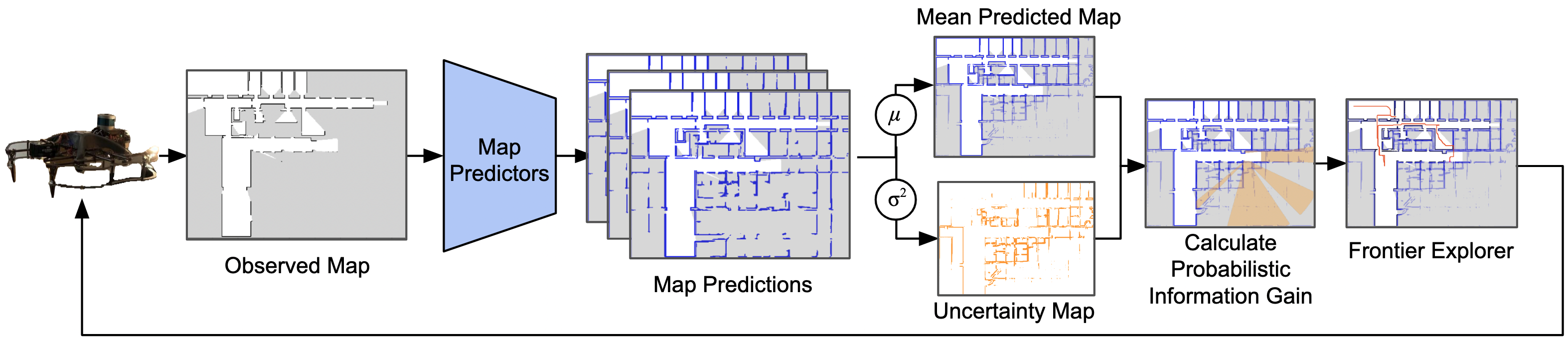
To efficiently explore indoor structured environments, we leverage predicted maps to find high probabilistic information gain areas. The MapEx pipeline is shown in Fig. 2, consisting of four key steps:
IV-A Global Map Prediction
While LiDAR provides an accurate occupancy map in observed areas, large areas in the environment often remain unobserved due to sensor range and occlusions, especially in indoor settings. Therefore, we use a global map prediction module , which predicts unknown regions and produces a complete predicted map as
| (1) |
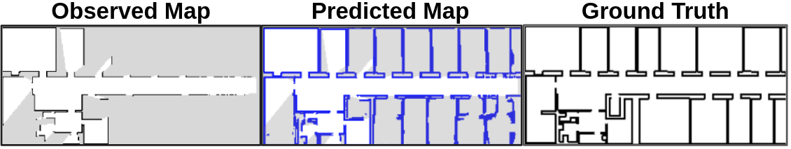
Given the prevalence of large unknown areas during indoor exploration, we use LaMa network architecture [26], which has image-wide receptive field and ability to understand global context, making it suitable for inpainting maps with large unknown areas. We treat a top-down view occupancy grid as a 2D image (where 1 pixel = m) and regard the unknown areas of the environment similarly to missing parts of an image. LaMa is used to predict what lies beyond the robot’s observation. To increase map prediction performance, we fine-tuned LaMa’s out-of-the-box Places2 weights using the KTH floorplan dataset[11]. Our training set consists of (observed map, ground truth map) data pairs collected through nearest-frontier exploration. Unlike prior works that predicts local maps [9, 10], we generate global predicted maps to enable more comprehensive global planning in exploration. Fig. 3 shows an example of an observed map, associated predicted map and ground-truth map.
IV-B Uncertainty Estimation and Variance Map
While the robot can reasonably predict the map given the observed map , there is inherent ambiguity in the unobserved areas. Therefore, the robot should estimate the uncertainty of the predictions. To achieve this, we maintain an ensemble of separate LaMa networks , and let each generate prediction:
| (2) |
We used the entire training set to fine-tune , and split the training set into subsets, each used to fine-tune the parameters of . This allows independent predictions given the same observed map . Using these predictions, we can generate a pixel-wise variance map :
| (3) |
In this work, we set prediction ensemble size .
IV-C Calculating Probabilistic Information Gain
To explore an unknown environment effectively, it’s crucial for the robot to move towards areas where it can gain the most information. This requires identifying viewpoints where the sensor coverage is high, as these locations provide the greatest potential for uncovering new areas, and also areas with high uncertainty. Accurate estimation of information gain is essential as poor estimates can lead to inefficient exploration. We detail how we derive probabilistic information gain using the predicted and variance maps defined in Sec. IV-A and IV-B. To estimate sensor visibility given uncertain predictions, relying on deterministic raycasting, as done in [36, 28], can lead to inaccurate results when the predicted maps are unreliable. To address this, we instead employ a probabilistic variant of raycasting. Fig. 4 illustrates the difference between raycast methods.
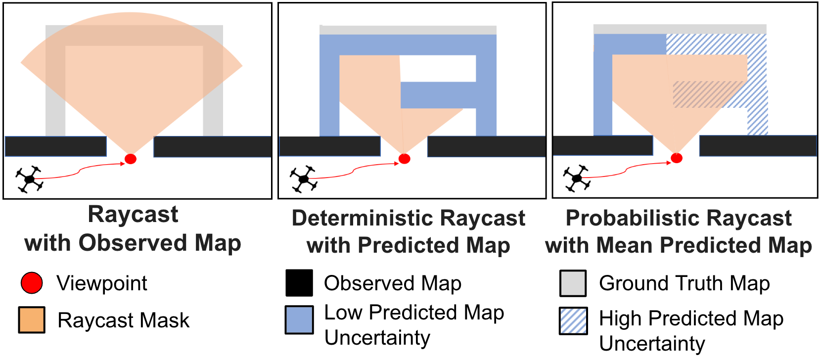
Given a viewpoint , we generate hypothetical rays (where ) with a range of , emitted in a pattern originating from . In a deterministic raycast approach, each ray stops when it hits an occupied cell, and if there are no obstructing cells along its path, reach the end at a distance of . In this work, we use a probabilistic raycast approach instead: first, we calculate the mean predicted map , which is the average of predicted maps . Each ray starts with an initial accumulated occupancy value , and as passes through the pixels of , it adds the occupancy value of each pixel in the mean map to . When reaches a threshold , the raycast terminates. Given ray end points, we perform a flood fill to generate a sensor coverage mask. We then mask out already observed areas from the sensor coverage mask to generate a visibility mask , which probabilistically represents the unknown area estimated to be visible at location . We then compute information gain I by summing the values of all pixels in the variance map that also fall within the visibility mask . In other words,
| (4) |
This information gain I estimates the potential reduction in uncertainty, not just by considering the size of observable area, but also the variance it will cover. Through empirical testing, we found that yields the best performance.
IV-D MapEx: Map Exploration with Prediction
Here, we explain how the MapEx algorithm is structured and uses the information gain values to augment a frontier-based explorer for efficient exploration. When the robot needs to select the next frontier, it generates a predicted map based on the current observed occupancy grid , and a variance map and ensembles of predictions . The frontiers are extracted from the boundary between known and unknown cells in , similar in [7]. When calculating the score for these frontiers, the information gain is measured as described in Sec. IV-C. To discourage backtracking, we divide each frontier score by the Euclidean distance from the current pose of the robot to each frontier, so that if the scores are similar, the robot prefers to select a closer frontier. Once the waypoint is chosen, a local path is generated using an A* local planner, and the robot moves along the path. The pseudocode of the algorithm can be found in Alg. 1.
V Experiments
We evaluate MapEx algorithm using a simulator on real-world floorplan datasets by comparing it with state-of-the-art baselines, and present ablation studies of the algorithm.
V-A Real-world Floorplan Dataset
To benchmark real-world performance, we use the KTH floorplan dataset [11], which after cleaning repeated maps, contains 149 campus floorplan blueprints described as XML files of wall and door locations for each room. We adapt the processing code from [37] to obtain the occupancy map. In addition, we correct incorrect areas of the processed map. We then downsample the map to m per pixel. For training the map predictor and then testing the navigation, we split the floorplans into an 80:20 train-test split. We take care to not include floorplans from the same building into both the train and test set, to test the generalizability of our method.
V-B Experimental Setup
All methods were tested on 10 held-out floorplans in the KTH dataset, over 1000 timesteps. The robot starts at the 4 corners of each floorplan, resulting in a total of 40 {floorplan, start pose} initial conditions. The robot is equipped with a LiDAR with a range of m and 2500 samples per scan. For the map predictor, we fine-tuned with 2367 images in the training set, with a batch size of 4 for 40 epochs.
V-C Baselines
We select three baselines for comparison, from which one is a classical frontier-based approach and two are representative map prediction-based exploration methods.
-
•
Nearest-Frontier[7]: A classical exploration approach that visits frontiers with lowest euclidean distance.
-
•
IG-Hector[9]: Map-prediction based approach that uses the predicted map to estimate a viewpoint’s sensor coverage and use it as information gain metric.
-
•
UPEN[10]: Map-prediction based approach that uses an ensemble of map predictions to estimate map prediction uncertainty that is used as exploration heuristic.
We also ablate the impact of different components of the information gain metric used by MapEx, to quantify the relative impact. For all methods, we kept the frontier exploration framework the same, with only the frontier scoring method different. Specifically, we investigate
-
•
Deterministic - Using deterministic raycast, instead of probabilistic raycast, on the predicted map.
-
•
No Variance - Summing number of pixels, instead of variance, in visibility mask, on the predicted map.
-
•
Observed Map - Using observed map for raycast. As there is no predicted maps to produce variance, we sum number of pixels in the visibility mask.
-
•
No Visibility - No raycast is done. We sum the variance within m of the viewpoint.
V-D Metrics
We evaluate our MapEx planner using a variety of metrics to fully evaluate the information gained by the robot: coverage, predicted map quality, and topological understanding.
Coverage: Percentage of the map observed by the robot.
Predicted Map Quality: The intersection over union (IoU) of the predicted 2D occupancy map and the ground truth occupancy map. Specifically, we use the IoU of the occupied class within the building footprint. Higher IoU means the predicted map is more accurate.
Topological Understanding: We propose a new metric, which we call Topological Understanding (TU), to directly assess how much the outcome of a robot’s exploration aids downstream path planning tasks. The TU metric is defined as follows: based on the exploration result up to timestep , we have a predicted map . Now we can plan an A* path from a starting point to an end-point goal. If the path successfully reaches the goal, it is considered a success. If the path collides with an occupied cell in the ground-truth map or fails to reach the goal, it is considered a failure. We measure success rates by sampling 100 random end-point goals for each map and start point across different methods.
V-E Comparison to Baseline Exploration Methods
V-E1 Qualitative Analysis
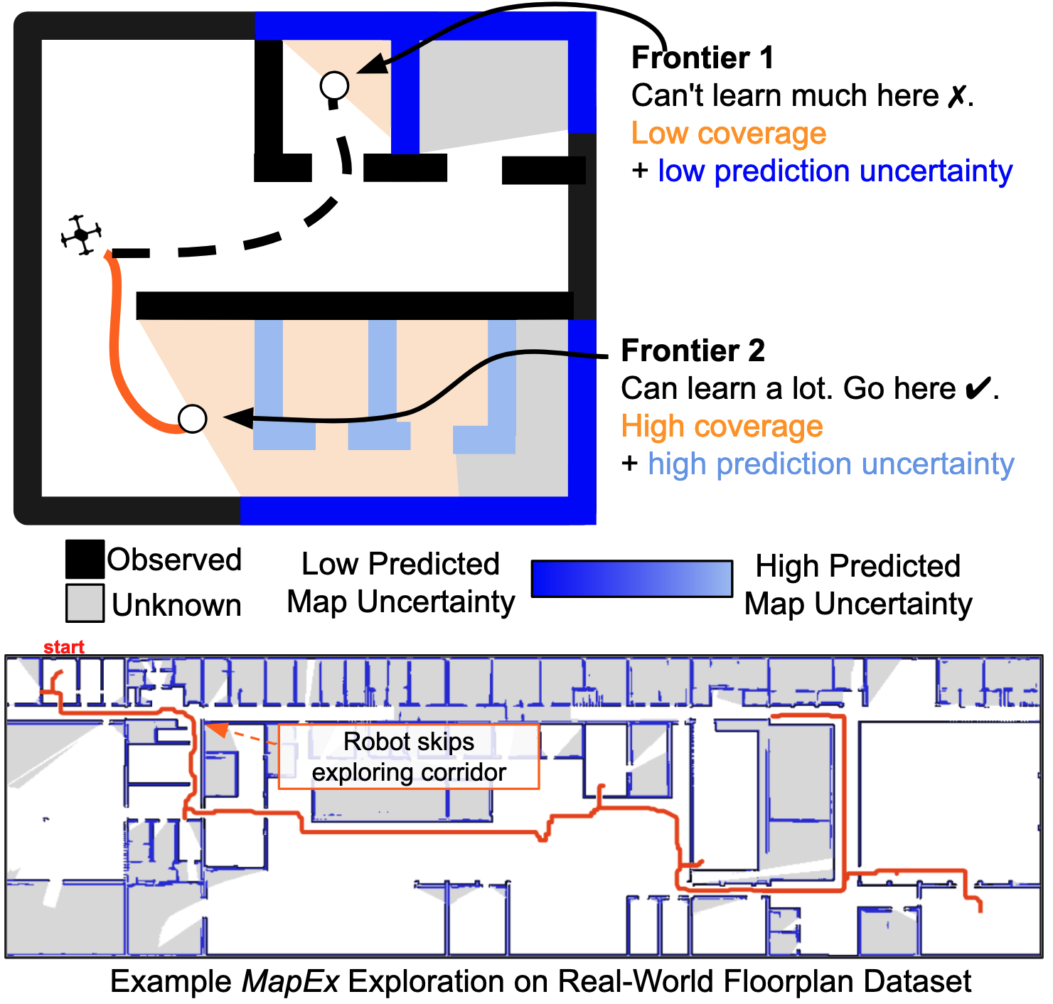
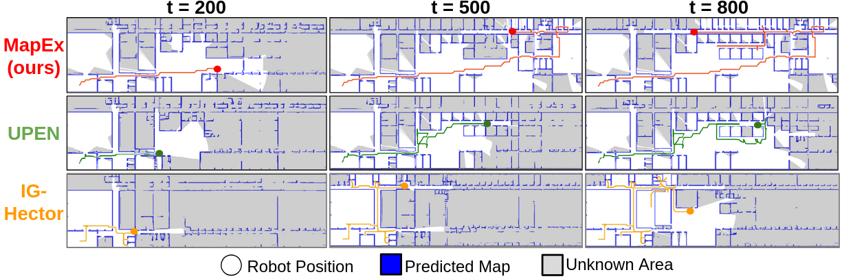
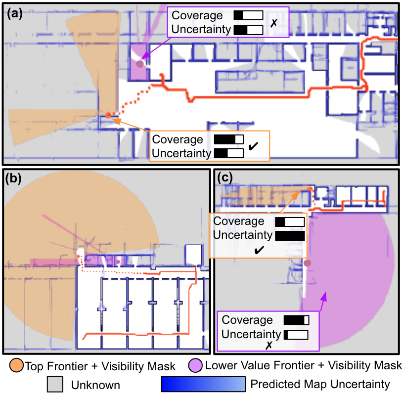
Fig. 5 compares exploration progress over time for one test map using different methods. UPEN [10] reasons on variance at the path and does not consider sensor coverage, likely leading it to explore areas with high variance near the center of the map. In contrast, at , MapEx also explores the center, but quickly shifts to a more informative hallway, estimating high sensor coverage. IG-Hector [9], which focuses on sensor coverage, struggles early likely due to poor map predictions, causing inefficient exploration of tight spaces. In comparison, as seen in , MapEx searches a relatively open area, gathering information about surrounding rooms. Overall, MapEx covers more informative areas within the same time frame, resulting in a better predicted map compared to the baselines. Fig. 6 provides more qualitative examples of the MapEx’s frontier scoring, showcasing the utility of jointly reasoning on sensor coverage and uncertainty. Fig. 6a,b show top-scoring frontiers with high sensor coverage with medium uncertainty. In contrast, Fig. 6c presents a scenario where MapEx selects a frontier that covers smaller area but has high uncertainty, rather than one with higher coverage but less potential for learning, highlighting the importance of reasoning about uncertainty.
V-E2 Quantitative Analysis
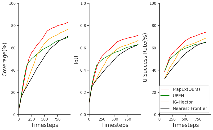
We compare MapEx’s exploration performance against the baselines in terms of coverage and predicted IoU. As shown in Fig. 7, MapEx achieves the best performance. The area under the curves show MapEx outperforms Nearest by 33.3% in coverage and by 22.9% in IoU, while improving on UPEN [10] by 16.2% in coverage and 9.9% in IoU, and on IG-Hector [9] by 15.5% in coverage and 12.3% in IoU. Nearest focuses on close frontiers, resulting in low coverage and IoU. UPEN initially shows steep gains by optimizing for high variance areas, but plateaus as it visits areas of low information gain. IG-Hector prioritizes high sensor coverage but struggles early likely due to poor map prediction. In contrast, MapEx reasons about both sensor coverage and uncertainty, yielding superior results throughout. We further compare MapEx with baselines using Topological Understanding (TU) metric to quantify the utility of the produced predicted maps (Fig. 7). MapEx surpasses Nearest by 20.1%, UPEN by 9.6%, and IG-Hector by 11.1%. Across all metrics, MapEx demonstrates 25.4% better performance than Nearest, and 12.4% better than map-prediction based exploration baselines.
V-F Ablation Studies
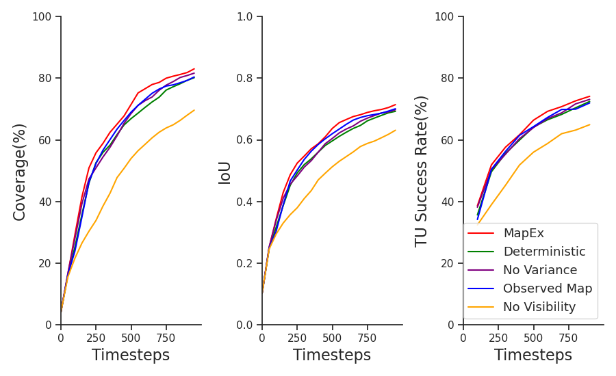
Next, we ablate the inclusion of different components of the information gain metric used by MapEx to quantify the relative impact. Fig. 8 compares the coverage, predicted IoU, and topological understanding. We find reasoning on sensor coverage to be critical, as No Visibility, which does not use visibility mask and only sums variance in nearby areas, shows poor exploration. Both No Variance and Deterministic show superior performance by considering sensor coverage. Interestingly, Observed Map, which reasons on observed map, shows competitive performance. This demonstrates the need for a good information gain metric when leveraging predicted maps. By jointly reasoning on sensor coverage and uncertainty, the full MapEx exhibits superior exploration performance and produces higher-utility predicted maps.
VI Conclusion
In this work, we proposed MapEx, a novel framework for exploration planning in indoor environments with structural predictability. The core of our approach is a probabilistic information gain metric, calculated from multiple predicted maps, which enables the exploration planner to jointly reason about sensor coverage and uncertainty of a given viewpoint. The metric is integrated into a frontier-based exploration framework as a frontier score. Extensive experiments on a real-world floorplan dataset demonstrate that MapEx significantly improves exploration performance compared to related map prediction-based algorithms, validating the utility of our frontier scoring method. Finally, we show that the explored maps exhibit superior topological understanding, making them more useful for downstream path planning tasks. For future work, we are interested in extending to multi-robot exploration [38] and exploring usage of reinforcement learning in a frontier framework [39] for improved performance.
VII Acknowledgement
We thank Simon Stepputtis, Yaqi Xie, David Fan and Mononito Goswami for helpful discussions.
References
- [1] C. Sampedro, A. Rodriguez-Ramos, H. Bavle, A. Carrio, P. de la Puente, and P. Campoy, “A fully-autonomous aerial robot for search and rescue applications in indoor environments using learning-based techniques,” Journal of Intelligent & Robotic Systems, vol. 95, pp. 601–627, 2019.
- [2] K. Schilling and C. Jungius, “Mobile robots for planetary exploration,” Control Engineering Practice, vol. 4, no. 4, pp. 513–524, 1996.
- [3] G. Hitz, A. Gotovos, M.-É. Garneau, C. Pradalier, A. Krause, R. Y. Siegwart, et al., “Fully autonomous focused exploration for robotic environmental monitoring,” in Proc. of IEEE International Conference on Robotics and Automation (ICRA), pp. 2658–2664, 2014.
- [4] B. Yamauchi, A. Schultz, and W. Adams, “Mobile robot exploration and map-building with continuous localization,” in Proc. of IEEE International Conference on Robotics and Automation (ICRA), vol. 4, pp. 3715–3720, 1998.
- [5] D. S. Chaplot, D. P. Gandhi, A. Gupta, and R. R. Salakhutdinov, “Object goal navigation using goal-oriented semantic exploration,” Advances in Neural Information Processing Systems, vol. 33, pp. 4247–4258, 2020.
- [6] S. Zhang, X. Zhang, T. Li, J. Yuan, and Y. Fang, “Fast active aerial exploration for traversable path finding of ground robots in unknown environments,” IEEE Transactions on Instrumentation and Measurement, vol. 71, pp. 1–13, 2022.
- [7] B. Yamauchi, “A frontier-based approach for autonomous exploration,” in Proc. of IEEE International Symposium on Computational Intelligence in Robotics and Automation (CIRA), pp. 146–151, 1997.
- [8] G. Best, R. Garg, J. Keller, G. A. Hollinger, and S. Scherer, “Multi-robot, multi-sensor exploration of multifarious environments with full mission aerial autonomy,” The International Journal of Robotics Research, vol. 43, no. 4, pp. 485––512, 2024.
- [9] R. Shrestha, F.-P. Tian, W. Feng, P. Tan, and R. Vaughan, “Learned map prediction for enhanced mobile robot exploration,” in Proc. of International Conference on Robotics and Automation (ICRA), pp. 1197–1204, 2019.
- [10] G. Georgakis, B. Bucher, A. Arapin, K. Schmeckpeper, N. Matni, and K. Daniilidis, “Uncertainty-driven planner for exploration and navigation,” in IEEE Conference on Robotics and Automation (ICRA), 2022.
- [11] A. Aydemir, P. Jensfelt, and J. Folkesson, “What can we learn from 38,000 rooms? Reasoning about unexplored space in indoor environments,” in Proc. of IEEE/RSJ International Conference on Intelligent Robots and Systems (IROS), pp. 4675–4682, 2012.
- [12] G. Best, R. Garg, J. Keller, G. A. Hollinger, and S. Scherer, “Resilient multi-sensor exploration of multifarious environments with a team of aerial robots,” in Proceedings of Robotics: Science and Systems, 2022.
- [13] F. Bourgault, A. A. Makarenko, S. B. Williams, B. Grocholsky, and H. F. Durrant-Whyte, “Information based adaptive robotic exploration,” in Proc. of IEEE/RSJ International Conference on Intelligent Robots and Systems (IROS), vol. 1, pp. 540–545, 2002.
- [14] S. Bai, J. Wang, F. Chen, and B. Englot, “Information-theoretic exploration with Bayesian optimization,” in Proc. of IEEE/RSJ International Conference on Intelligent Robots and Systems (IROS), 2016.
- [15] S. Kim, S. Bhattacharya, R. Ghrist, and V. Kumar, “Topological exploration of unknown and partially known environments,” in Proc. of IEEE/RSJ International Conference on Intelligent Robots and Systems (IROS), pp. 3851–3858, 2013.
- [16] C. Cao, H. Zhu, H. Choset, and J. Zhang, “TARE: A hierarchical framework for efficiently exploring complex 3D environments.,” in Proc. of Robotics: Science and Systems, vol. 5, 2021.
- [17] M. Bertalmio, L. Vese, G. Sapiro, and S. Osher, “Simultaneous structure and texture image inpainting,” IEEE Transactions on Image Processing, vol. 12, no. 8, pp. 882–889, 2003.
- [18] J. Hays and A. A. Efros, “Scene completion using millions of photographs,” ACM Transactions on Graphics (ToG), vol. 26, no. 3, pp. 4–es, 2007.
- [19] G. Liu, F. A. Reda, K. J. Shih, T.-C. Wang, A. Tao, and B. Catanzaro, “Image inpainting for irregular holes using partial convolutions,” in Proc. of European Conference on Computer Vision (ECCV), pp. 85–100, 2018.
- [20] D. Pathak, P. Krahenbuhl, J. Donahue, T. Darrell, and A. A. Efros, “Context encoders: Feature learning by inpainting,” in Proc. of IEEE Conference on Computer Vision and Pattern Recognition, 2016.
- [21] Y. Song, C. Yang, Y. Shen, P. Wang, Q. Huang, and C. J. Kuo, “Spg-net: Segmentation prediction and guidance network for image inpainting,” in British Machine Vision Conference 2018, BMVC 2018, Newcastle, UK, September 3-6, 2018, p. 97, BMVA Press, 2018.
- [22] C. Ho, J. Zou, O. Alama, S. M. J. Kumar, B. Chiang, T. Gupta, C. Wang, N. Keetha, K. Sycara, and S. Scherer, “Map it anywhere (mia): Empowering bird’s eye view mapping using large-scale public data,” 2024.
- [23] M. Stölzle, T. Miki, L. Gerdes, M. Azkarate, and M. Hutter, “Reconstructing occluded elevation information in terrain maps with self-supervised learning,” IEEE Robotics and Automation Letters, vol. 7, no. 2, pp. 1697–1704, 2022.
- [24] S. Triest, D. D. Fan, S. Scherer, and A.-A. Agha-Mohammadi, “Unrealnet: Learning uncertainty-aware navigation features from high-fidelity scans of real environments,” in 2024 IEEE International Conference on Robotics and Automation (ICRA), 2024.
- [25] S. Aich, W. Wang, P. Maheshwari, M. Sivaprakasam, S. Triest, C. Ho, J. M. Gregory, J. G. R. I. au2, and S. Scherer, “Deep bayesian future fusion for self-supervised, high-resolution, off-road mapping,” 2024.
- [26] R. Suvorov, E. Logacheva, A. Mashikhin, A. Remizova, A. Ashukha, A. Silvestrov, N. Kong, H. Goka, K. Park, and V. Lempitsky, “Resolution-robust large mask inpainting with Fourier convolutions,” in Proc. of IEEE/CVF Winter Conference on Applications of Computer Vision, pp. 2149–2159, 2022.
- [27] H. J. Chang, C. S. G. Lee, Y.-H. Lu, and Y. C. Hu, “P-slam: Simultaneous localization and mapping with environmental-structure prediction,” IEEE Transactions on Robotics, vol. 23, no. 2, pp. 281–293, 2007.
- [28] M. Luperto and F. Amigoni, “Reconstruction and prediction of the layout of indoor environments from two-dimensional metric maps,” Engineering Applications of Artificial Intelligence, vol. 113, p. 104910, 2022.
- [29] S. K. Ramakrishnan, Z. Al-Halah, and K. Grauman, “Occupancy anticipation for efficient exploration and navigation,” in Proc. of European Conference on Computer Vision (ECCV), pp. 400–418, 2020.
- [30] Y. Tao, E. Iceland, B. Li, E. Zwecher, U. Heinemann, A. Cohen, A. Avni, O. Gal, A. Barel, and V. Kumar, “Learning to explore indoor environments using autonomous micro aerial vehicles,” in 2024 IEEE International Conference on Robotics and Automation (ICRA), pp. 15758–15764, 2024.
- [31] E. Zwecher, E. Iceland, S. R. Levy, S. Y. Hayoun, O. Gal, and A. Barel, “Integrating deep reinforcement and supervised learning to expedite indoor mapping,” in 2022 International Conference on Robotics and Automation (ICRA), pp. 10542–10548, 2022.
- [32] L. Ericson and P. Jensfelt, “Beyond the frontier: Predicting unseen walls from occupancy grids by learning from floor plans,” IEEE Robotics and Automation Letters, vol. 9, no. 8, pp. 6832–6839, 2024.
- [33] M. Saroya, G. Best, and G. A. Hollinger, “Online exploration of tunnel networks leveraging topological CNN-based world predictions,” in Proc. of IEEE/RSJ International Conference on Intelligent Robots and Systems (IROS), pp. 6038–6045, 2020.
- [34] V. D. Sharma, A. Singh, and P. Tokekar, “Pre-trained masked image model for mobile robot navigation,” in IEEE International Conference on Robotics and Automation, ICRA 2024, Yokohama, Japan, May 13-17, 2024, pp. 5126–5133, IEEE, 2024.
- [35] A. H. Tan and G. Nejat, “Enhancing robot task completion through environment and task inference: A survey from the mobile robot perspective,” Journal of Intelligent & Robotic Systems, vol. 106, no. 4, p. 73, 2022.
- [36] M. Luperto, L. Fochetta, and F. Amigoni, “Exploration of indoor environments through predicting the layout of partially observed rooms,” in Proceedings of the 20th International Conference on Autonomous Agents and MultiAgent Systems, AAMAS ’21, (Richland, SC), p. 836–843, International Foundation for Autonomous Agents and Multiagent Systems, 2021.
- [37] J. A. Caley, N. R. Lawrance, and G. A. Hollinger, “Deep learning of structured environments for robot search,” in Proc. of IEEE/RSJ International Conference on Intelligent Robots and Systems (IROS), pp. 3987–3992, 2016.
- [38] S. Kim, M. Corah, J. Keller, G. Best, and S. Scherer, “Multi-robot multi-room exploration with geometric cue extraction and circular decomposition,” IEEE Robotics and Automation Letters, vol. 9, no. 2, pp. 1190–1197, 2024.
- [39] Y. Hu, J. Geng, C. Wang, J. Keller, and S. Scherer, “Off-policy evaluation with online adaptation for robot exploration in challenging environments,” IEEE Robotics and Automation Letters, vol. 8, no. 6, pp. 3780–3787, 2023.