V-RoAst A New Dataset for Visual Road Assessment
Abstract
Road traffic crashes cause millions of deaths annually and have a significant economic impact, particularly in low- and middle-income countries (LMICs). This paper presents an approach using Vision Language Models (VLMs) for road safety assessment, overcoming the limitations of traditional Convolutional Neural Networks (CNNs). We introduce a new task ,V-RoAst (Visual question answering for Road Assessment), with a real-world dataset. Our approach optimizes prompt engineering and evaluates advanced VLMs, including Gemini-1.5-flash and GPT-4o-mini. The models effectively examine attributes for road assessment. Using crowdsourced imagery from Mapillary, our scalable solution influentially estimates road safety levels. In addition, this approach is designed for local stakeholders who lack resources, as it does not require training data. It offers a cost-effective and automated methods for global road safety assessments, potentially saving lives and reducing economic burdens.
1 Introduction
Road traffic incidents were estimated to cause 1.19 million deaths worldwide in 2021 (WHO 2023), with an economic impact of approximately 10-12% of the global Gross Domestic Product (GDP) (WHO 2023; Chen et al. 2019). In low- and middle-income countries (LMICs), road crashes rank as the leading cause of death, with fatality rates significantly higher than those of high-income countries (HICs). A significant portion of these fatalities involves motorcyclists, who are among the most vulnerable road users in LMICs. Consequently, the United Nations (UN) has aimed to ensure that all new roads are built to achieve a rating of at least 3 stars according to the International Road Assessment Programme (iRAP) standard for all road users, including cars, motorcycles, bicycles, and pedestrians. The rating scale ranges from 1 to 5, with 5 indicating a safe road and 1 indicating an unsafe road (WHO 2023). Furthermore, another objective is to improve 75% of existing roads to more than 3 stars by 2030.
The workflow of iRAP involves road surveys, coding attributes, developing the model, and analysing the results. Road surveying requires vehicles and sensors to capture accurate georeferenced images for coding. Once georeferenced images are obtained, trained coders must examine and classify the images according to the codebook manual (iRAP 2024a, b), which requires training and experience. Currently, only highways have been rated due to the prohibitive cost of the survey. Importantly, it is almost impossible for LMICs to assess all roads following this standard. This leaves the vast majority of the road network unrated, making it difficult to reveal the infrastructure risk factors contributing to road deaths.
Although Accelerated and Intelligent RAP (AiRAP) has initiated several programmes to help provide tools and attributes to local authorities, these programmes do not cover all cities and countries and come with associated costs. To save costs, automated road feature detection directly from captured images is a well-known approach that primarily employs models based on Convolutional Neural Networks (CNN). Although they are inexpensive compared to manual labelling, these models require labelled data for training, which is time-consuming and limits region-scalability since road attributes can visually vary in different cities and countries (Kacan et al. 2020; Pubudu Sanjeewani and Verma 2019; Jan et al. 2018; Sanjeewani and Verma 2021b, a). Additionally, some works explore alternative data sources, such as Light Detection and Ranging (LiDAR) (Brkić et al. 2022), satellite imagery (Brkić et al. 2023; Abdollahi et al. 2020), Unmanned Aerial Vehicles (UAV) (Brkić et al. 2020), and Global Positioning System (GPS) traces (Yin et al. 2023).
Recently, many scholars have explored the performance of visual language models (VLMs) on various computer vision tasks. Since VLMs have been trained on large datasets of images and texts, they can perform tasks without additional model training. Recently, techniques such as prompt engineering, retrieval-augmented generation (RAG), and fine-tuning have been explored to enhance the potential of VLMs, as building these models requires significant computational resources and datasets. Furthermore, VLMs have shown their potential to handle complex tasks using zero-shot learning, such as building age classification (Zeng et al. 2024), building detection (Goo, Zeng, and Boehm 2024), motorcycle risk assessment (Jongwiriyanurak et al. 2023), land use classification (Wu et al. 2023), and building defects detection (Yong et al. 2023). However the zero-shot prediction and generalisation ability of VLMs on the road feature detection task is still unknown. Therefore, this work focusses on the potential of using VLMs to assist in road assessment.
This study develops prompts for VLMs to examine iRAP attributes by mimicking a coder observing an image and categorizing the attributes, as described in (iRAP 2024a, b). In summary, we state the main contributions of our work as follows:
-
•
We proposed a new image classification task for VLMs with a real-world dataset from ThaiRAP
-
•
We optimize the prompts and evaluate the potential of using VLMs to code road attributes using Gemini-1.5-Flash and GPT-4o-mini compared to traditional computer vision models
-
•
We present a scalable approach using crowdsourced imagery, Mapillary, to estimate star ratings
2 Related Work
2.1 Computer Vision for Road Attribute Detection
Using engineers to survey, inspect, and assess roads on-site is time-consuming. Therefore, various studies have explored the use of computer vision models to assist in specific tasks, such as crack detection (Goo et al. 2024), pothole detection (Ma et al. 2022), and pavement distress detection (Ibragimov et al. 2022).
Similarly, examining road attributes following the iRAP standards has been dramatically advanced using images and videos. The availability of the AusRAP dataset with labelled street objects has enabled the development of models to detect street attributes. However, due to the limitations of visual scenes from videos and the feasibility of labelling objects (e.g., lane lines, rumble strips, poles, trees, barriers, and speed signs), only 13 attributes were able to be estimated (Jan et al. 2018; Pubudu Sanjeewani and Verma 2019; Sanjeewani and Verma 2021b).
In perspective of model architectures, Fully Convolutional Network (FCN) effectively segmented objects and defined attributes from images (Sanjeewani and Verma 2021a). Song et al. (2018) automated the process using star ratings from ground-level panoramic images. They developed a VGG-based model incorporating a task-dependent spatial attention layer, which was trained in a supervized multi-task learning manner. However, the task mainly focused on predicting star rating scores rather than coding road attributes. Some works have proposed multi-task convolutional models using monocular videos to predict 33 attributes (Kačan, Ševrović, and Šegvić 2022; Kacan et al. 2020). However, all these works required large amounts of training data with dense pixel-level annotation, indicating significant annotation effort and substantial computational resources.
In addition, due to dataset imbalances, these works struggle with certain road features, such as pedestrian fencing and facilities for motorcycles and bicycles. Consequently, some of the attributes experience the problem of out-of-distribution (OOD), i.e., some attributes have classes with only a small amount of data or even missing data (Hendrycks and Gimpel 2016). This makes multi-attribute classification more challenging. Hence, these models require significant additional training data, even when using transfer learning or semi-supervized learning approaches.
To sum up, previous works benefit from the availability of datasets and can detect, segment, and classify attributes required for automated road assessments. Traditional computer vision models show limitations on datasets with OODs due to overfitting to the majority classes of distribution(Hendrycks and Gimpel 2016).
2.2 Vision Language Models
In recent years, Large Vision Language Models (LVLMs) have become significantly important in computer vision domain. VLMs can process image and text inputs and produce text outputs that can be used in many tasks, such as image captioning, image-text matching, visual reasoning, and visual question answering (VQA). LVLMs have been extensively developed by leading researchers using large amounts of text and image datasets with different architectures. Examples include GPT 4o (OpenAI 2024), Gemini 1.5 (Team 2024), CogVLM2 (Wang et al. 2024), and QwenVL (Bai et al. 2023). These models have been evaluated for their potential to outperform several traditional deep learning state-of-the-art benchmarks, including motion understanding (Zhou, Wan, and Wang 2023), 3D object generation (Siddiqui et al. 2023), and image segmentation (Hoyer et al. 2023). However, these models come with different licences, costs, and limitations.
VLMs have also been trained, fine-tuned, and validated to understand street scenes, primarily focusing on the autonomous driving domain (Min et al. 2024; Wang et al. 2023; Yang et al. 2024). These models mainly focus on controlling, object detection, and depth estimation rather than captioning street scenes. Besides, Wen et al. (2023) explored GPT-4vision and demonstrated its great potential for understanding street scenes by captioning images as one of the tasks for autonomous driving. However, challenges remain in traffic light recognition, vision grounding, and spatial reasoning tasks. Luo et al. (2024), on the other hand, explored foundation models for understanding road scenes with the potential usage of existing road scene datasets. Moreover, for finer-grained image understanding, Zeng et al. (2024), used GPT-4 to extract building features and classify building attributes from the street imagery without any training data. These works demonstrated the potential of VLMs for zero-shot understanding of road images, which can be an alternative for automated road feature detection with OOD problems. Inspired by them, in this study, we explore the attribute coding capabilities of VLMs.
2.3 VQA
Visual Question Answering (VQA) was initially introduced as a new task in the computer vision and natural language processing domains (Agrawal et al. 2016). The task involves answering open-ended questions based on images. Several datasets are commonly used to evaluate models, including GQA (Hudson and Manning 2019), OK-VQA (Marino et al. 2019), A-OKVQA (Marino et al. 2019), and MMMU (Hendrycks et al. 2021).
In addition, VQA datasets focusing on autonomous vehicles, such as KITTI (Geiger et al. 2013) and NuScenes-QA (Qian et al. 2024), have been used to advance the field. Jain et al. (2024) found that GPT-4 performs well in robust driving scenarios.
This work uses a real-world dataset to define a new image classification dataset for VLMs as a downstream vision application. It does not consider training a new VLM, but instead explores the potential of existing LVLMs to perform the task as road assessment coders. Although using non-open-source models incurs some costs, this study aims to demonstrate that coding road assessments can benefit from existing LVLMs. It also allows for applying prompt engineering, retrieval-augmented generation (RAG), fine-tuning, or even building a new LVLM model.
3 Data and Experiments
3.1 ThaiRAP Dataset
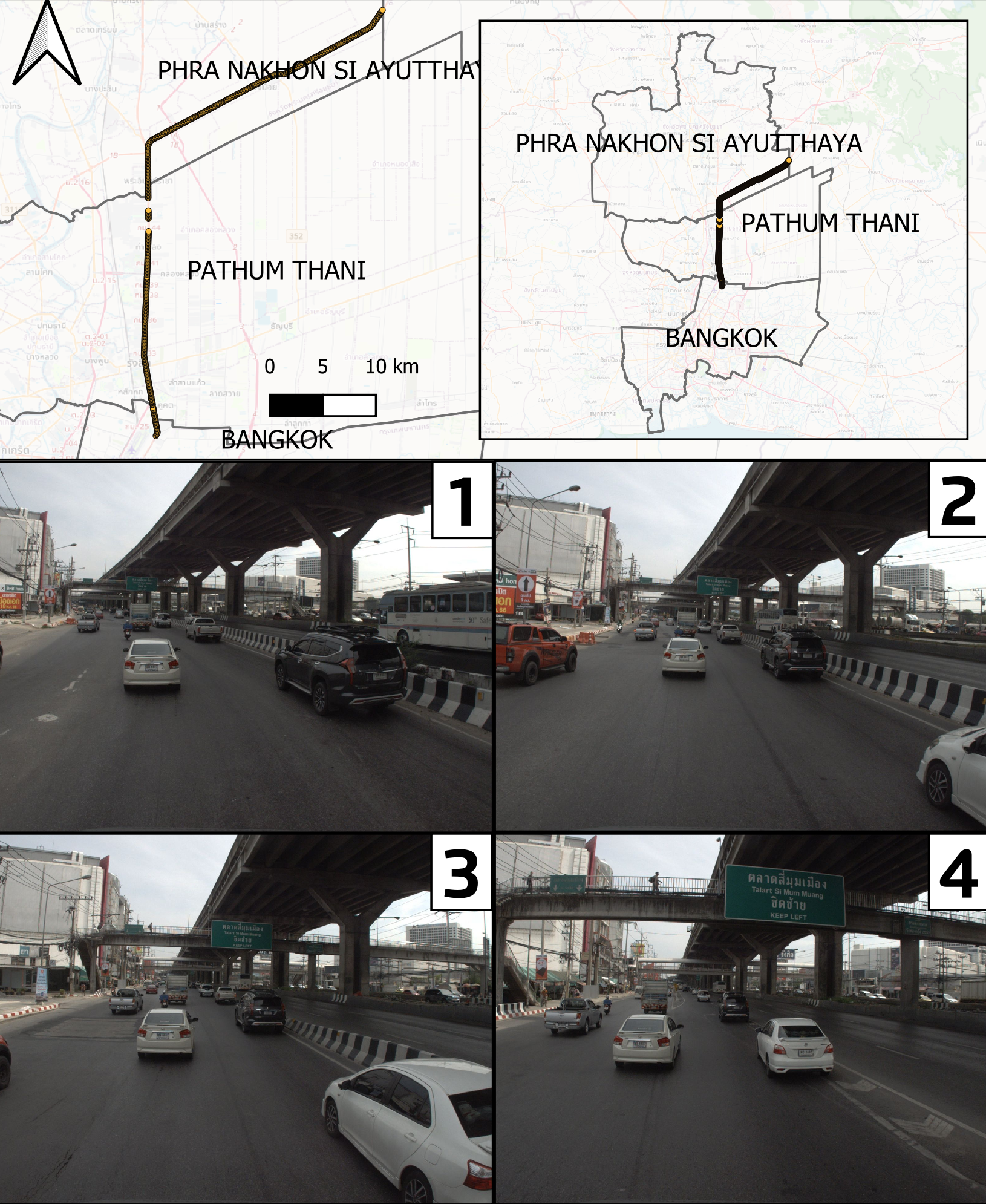
The dataset used in this work is sourced from the ThaiRAP and was selected due to the availability of road assessment datasets adhering to the iRAP standard. The experiment includes 2,037 images (1600x1200 pixels) captured across Bangkok, Pathum Thani, and Phranakorn Sri Ayutthaya provinces, as illustrated in Figure 1. These images represent 519 road segments, with 1-4 images used to code each 100-meter segment. While iRAP datasets are typically not publicly available, this work will provide access to the ThaiRAP dataset, including both the images and their associated attributes, to support further research and development in road safety assessment.
Road Attributes
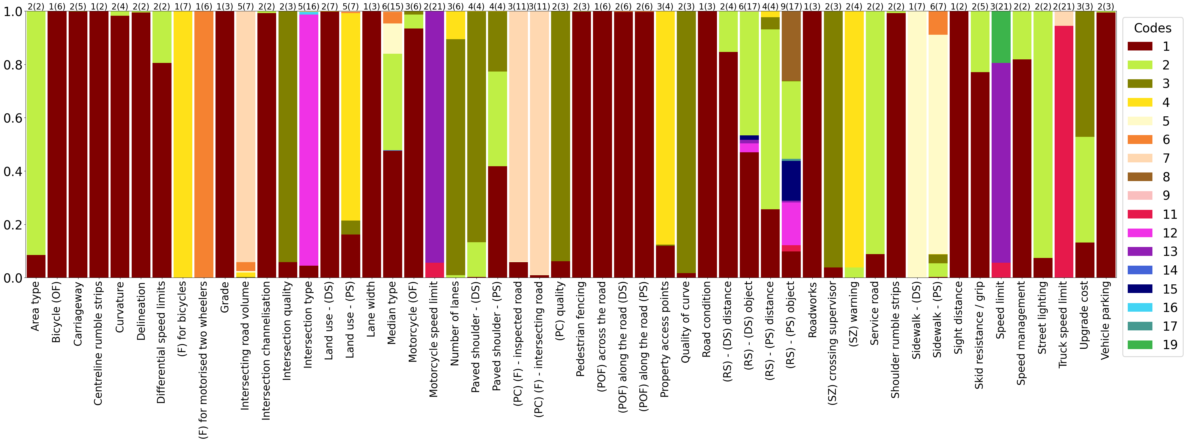
Each segment has 52 attributes classified by iRAP (iRAP 2024a, b). However, the attributes have a different number of classes (codes) in (parenthesis), and the number of classes of each attribute used in this experiment is shown at the top of each bar in Figure 2. This dataset shows the imbalance of classes of attributes, in which there are 11 attributes with only one class. And some classes have less than 10 samples.
Data preprocessing
To evaluate and compare our models against the baseline models - traditional computer vision methods, we divide the dataset (n=2037) into a training set (1274 original samples + 464 augmented samples), a testing set (492 samples), a validation set (243 samples), and an unseen set (28 samples). The dataset is split by ensuring a balanced distribution across subsets, maintaining sample sizes for each class within the attribute. The data split follows these rules: 1. Attributes with only one class are ignored; 2. Classes with more than 4 but fewer than 12 samples are augmented; 3. Classes with 4 or fewer samples are augmented if their attributes have only 2 classes; 4. Samples from classes with 4 or fewer samples are moved to the unseen set if their attributes have more than 2 classes.
For rules 2 and 3, we generate noise-added data and added them to the training dataset to alleviate the class imbalance problem in our dataset. Specifically, we add 5 different types of noise: Gaussian noise, salt and pepper noise, speckle noise, periodic noise, and quantisation noise for each selected image. For rule 4, the unseen set is used to test the zero-shot prediction capacities in unseen classes. The baseline models have been trained on the training set and monitored by the validation set. The performance of both our models and the baseline models are evaluated in the testing set and the unseen set.
3.2 Baseline
VGGNet (Simonyan and Zisserman 2015) is a deep neural network model known for its simple architecture that stacks multiple convolutional layers with small 3x3 filters, achieving high performance in image classification tasks and becoming a widely used baseline in computer vision.
ResNet (He et al. 2015) is also a deep convolutional neural network that utilizes residual blocks and skip connections to enhance feature learning at various abstraction levels, making it highly effective for image classification and transfer learning tasks.
In our study, we use VGGNet and ResNet as baseline models to compare with our proposed approach. Since these models are designed for a single classification task, we design the baseline model architectures for a multi-attribute classification problem, where a single encoder is shared across all tasks, and separate decoders are allocated for each individual task. This structure allows the model to extract the common features from the encoders and use the features to address each task using task-specific decoders.
3.3 Experiments
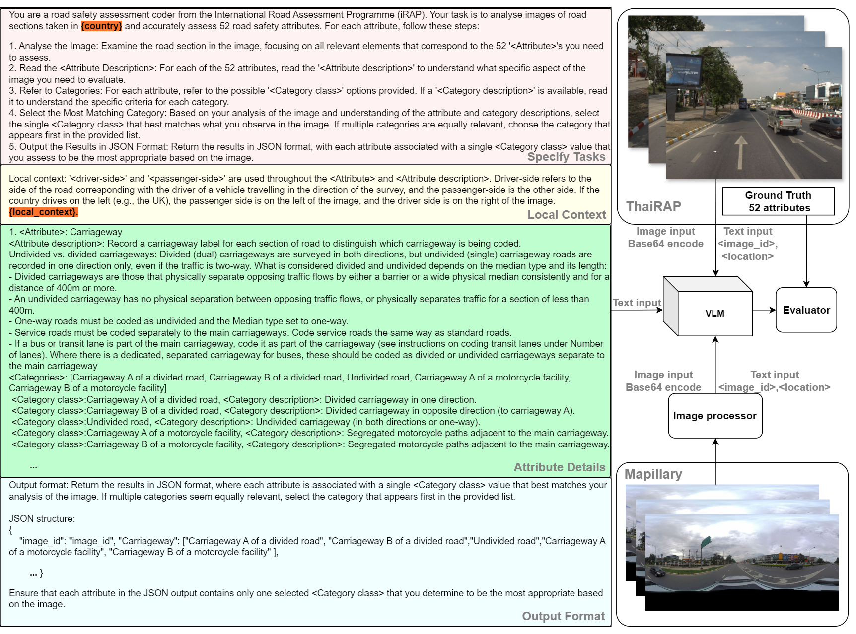
In this section, we evaluate the framework of our proposed approach, V-RoASt, for examining 52 iRAP attributes from images, as shown in Figure 3. This framework is designed to be easily applicable in any city, requiring minimal data science expertise and coding experience. The approach includes text input for system instructions and prompts, as well as image prompts. The workflow operates by inputting an image and its associated information prompts, including task descriptions, contextual information, and output format, to generate responses for the 52 attributes of the image. We used data from ThaiRAP to evaluate the VLMs, as described in section 3.1.
Instructions
As shown in the left box of Figure 3, instructions are divided into four parts: task specification, local context, attribute details, and output format. In the first part, task specification, we outline five steps to process each image step-by-step by giving instructions to define Category class of each Attribute with its description from the image. The model is also instructed on how to format the output. This section includes country, which must be specified for VLM inference.
In the local context part, we provide information for the model since attributes are related to the side of the road on which countries drive (left or right). Specifying {country} helps VLMs understand which side of the image to consider. Importantly, we provide {local_context}, allowing local stakeholders to add information, such as speed limit laws or specific details of road attributes, to influence the models.
The next section details the 52 attributes (Attribute) taken from iRAP coding manuals (iRAP 2024b, c). Each Attribute includes the attribute name, attribute description (Attribute description), and information on possible classes, including each class name (Category class) and class description (Category description).
Lastly, we format the output by instructing the models to return the results in JSON format. We provide possible classes as a list and remind the model to choose the best match for each Category class.
Prompts
In this experiment, we input an image and its information, including the tags image_id: {image_id} and location: {latitude, longitude}. These prompts assist VLMs in formatting the output by referencing the image ID and incorporating location data, which aids in both image interpretation and contextual analysis. For example, by integrating local speed limit laws, VLMs can more effectively assess attributes such as motorcycle speed limits, truck speed limits, general speed limits, and differential speed limits, thereby enhancing the accuracy and relevance of the analysis within the context of local regulations. The following section will provide information on VLMs used in this study and experiment setup.
3.4 VLMs
This study utilizes Gemini-1.5-flash and GPT-4o-mini to evaluate the framework and assess the potential of Visual Language Models (VLMs) to replicate the work of road safety auditors using the iRAP standard. Notably, Gemini-1.5-flash and GPT-4o-mini do not require any training or significant computational resources, making them accessible for use by local stakeholders. The experiments were conducted through the Google AI Gemini platform and the OpenAI API.
In this study, 337 segments were used to evaluate the results of Gemini-1.5-flash and GPT-4o-mini with the ResNet and VGG baseline models. Moreover, Unseen has 7 segments in total.
3.5 Image processor for Mapillary imagery
Crowdsourced Street View Images (SVIs) are accessible on various platforms, with Mapillary being one of the most well-known, providing an API for image downloads. For this study, images were obtained using a 50-meter buffer around ThaiRAP locations, under the condition that the images were captured within one year of the coding date, as the specific date of the road survey was unavailable. However, only 42 road segments were found to have corresponding Mapillary images, yielding 165 images. Panoramic images were converted to 1200x1600 binocular view images to align with the ThaiRAP data format. Subsequently, these images were processed using V-RoASt to examine attributes, as explained in 3.3. Other required attributes unavailable in the images were sourced from ground truth data. All attributes were then used to evaluate the star rating for all modes of transport, including cars, motorcycles, pedestrians, and bicycles, and these were compared against the ground-truth star ratings.
3.6 Evaluation Metrics
Coding options for each attribute are listed in order from highest to lowest risk. Therefore, if an attribute varies within a single coding segment, record the item that appears first in the list of options for that attribute.
We propose this VQA as an image classification task. To measure the performance of our model, we employ standard evaluation metrics in the field of image classification to measure the performance of our model.
4 Results and Discussions
In this section, we evaluate the attribute classification performance of V-RoAst using Gemini-1.5-flash and GPT-4o-mini, compared to the baselines established by the ResNet and VGG models, as used in previous studies (Song et al. 2018; Kacan et al. 2020). The following subsections will discuss the classification results using 4 metrics: accuracy, precision, recall, and F1 score.
Attributes Comparison
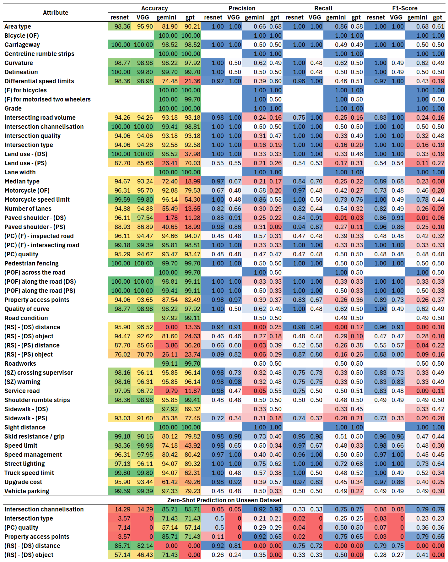
As previously noted, the VGG and ResNet models excluded 11 attributes due to their reliance on datasets where these attributes had only a single class. In contrast, V-RoAst overcomes this limitation, as Visual Language Models (VLMs) do not require a training dataset to handle these attributes effectively.
As shown in Figure 4, our baseline model trained through supervized learning outperforms VLMs on most attributes. However, it is noteworthy that VLMs, despite being evaluated on previously unseen datasets, achieve performance close to that of supervized learning models in some attributes. Overall, VLMs perform well on attributes that do not possess strong spatial characteristics or are related to the presence or absence of prominent objects. In contrast, their performance significantly drops when recognising distance-related attributes or objects with ambiguous features. To directly compare VLMs and baseline models in the same environments, we evaluated their performance on datasets that were excluded during the training of the baseline models. As described in the Figure 4, VLMs generally demonstrate strong performance on unseen data. Interestingly, the baseline model performs well on data involving spatial information, such as distance, even though it did not see such data during training. This suggests that the spatial information learned in other tasks may have been transferred during the multi-attribute learning process.
The attributes where VLMs perform well are also crucial for assessing road safety, indicating that VLMs have promising potential in this area. Given the strong performance of baseline models on problems involving spatial information, a collaborative approach where VLMs receive support from baseline models in handling spatial information could yield improved results.
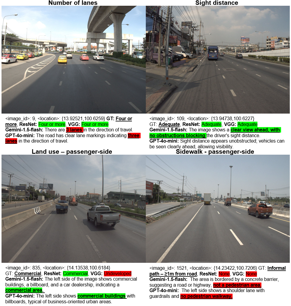
Qualitative Assessment using VQA
One of the key advantages of using LVLMs is their ability to perform VQA tasks. This capability enables non-data science experts to improve the models by intuitively adapting prompts based on what the LVLMs interpret from text and image inputs, as illustrated in Figure 5. This interaction allows for an iterative process in which prompts can be adjusted to refine the model’s predictions, particularly when discrepancies are identified between the output of the model and the ground truth.
4.1 Scalable Star Rating Prediction
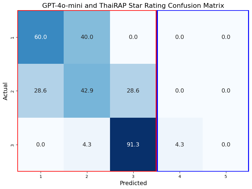
Figure 6 presents the confusion matrix of the RoAst and GPT-4o-mini models using Mapillary images. Our approach effectively identifies high-risk roads with ratings below 3 stars for motorcyclists, as indicated in the red box. Additionally, the results confirm that our method maintains a conservative stance in assessing safety levels. These results highlight the potential of using crowdsourced imagery data for star rating prediction on a national scale. The V-RoAst approach benefits from incorporating {local_context}, enabling local stakeholders to customize prompts based on their expertize and validate results with ground truth data. This flexibility allows for the precise identification of roads requiring improvements, thereby supporting the prioritization of road safety initiatives and investments. Although the current coverage of Mapillary data is limited, the crowdsourced platform provides a valuable resource that transport authorities can leverage. Besides, commercial platforms such as Google Street View could be employed similarly, subject to license agreements.
5 Conclusion
In this study, we proposed the V-RoAst approach utilizing Visual Language Models (VLMs) such as Gemini-1.5-flash and GPT-4o-mini, and compared their performance with traditional CNN models like ResNet and VGG. The results indicate that our approach classifies road attributes effectively as the traditional models. Additionally, the V-RoAst approach leverages VLMs’ ability to perform Visual Question Answering (VQA), enabling local authorities in LMICs to adapt and enhance accuracy through intuitive prompt engineering. However, it is noted that VLMs demonstrate relatively weaker performance in dealing with spatial attributes.
V-RoAst offers a cost-effective and automated method for global road safety assessments, potentially saving lives and reducing economic burdens. Fine-tuning VLMs for robustness and versatility regardless of the country remains a future work. Moreover, other modalities, such as remote sensing imagery and geographical information data, can be beneficial for reliable road assessment.
References
- Abdollahi et al. (2020) Abdollahi, A.; Pradhan, B.; Shukla, N.; Chakraborty, S.; and Alamri, A. 2020. Deep Learning Approaches Applied to Remote Sensing Datasets for Road Extraction: A State-Of-The-Art Review. Remote Sensing, 12(9): 1444.
- Agrawal et al. (2016) Agrawal, A.; Lu, J.; Antol, S.; Mitchell, M.; Zitnick, C. L.; Batra, D.; and Parikh, D. 2016. VQA: Visual Question Answering. ArXiv:1505.00468 [cs].
- Bai et al. (2023) Bai, J.; Bai, S.; Yang, S.; Wang, S.; Tan, S.; Wang, P.; Lin, J.; Zhou, C.; and Zhou, J. 2023. Qwen-VL: A Versatile Vision-Language Model for Understanding, Localization, Text Reading, and Beyond. ArXiv:2308.12966 [cs].
- Brkić et al. (2020) Brkić, I.; Miler, M.; Ševrović, M.; and Medak, D. 2020. An Analytical Framework for Accurate Traffic Flow Parameter Calculation from UAV Aerial Videos. Remote Sensing, 12(22): 3844.
- Brkić et al. (2022) Brkić, I.; Miler, M.; Ševrović, M.; and Medak, D. 2022. Automatic Roadside Feature Detection Based on Lidar Road Cross Section Images. Sensors, 22(15): 5510.
- Brkić et al. (2023) Brkić, I.; Ševrović, M.; Medak, D.; and Miler, M. 2023. Utilizing High Resolution Satellite Imagery for Automated Road Infrastructure Safety Assessments. Sensors, 23(9): 4405.
- Chen et al. (2019) Chen, S.; Kuhn, M.; Prettner, K.; and Bloom, D. E. 2019. The global macroeconomic burden of road injuries: estimates and projections for 166 countries. The Lancet Planetary Health, 3(9): e390–e398.
- Geiger et al. (2013) Geiger, A.; Lenz, P.; Stiller, C.; and Urtasun, R. 2013. Vision meets robotics: The KITTI dataset. The International Journal of Robotics Research, 32(11): 1231–1237.
- Goo et al. (2024) Goo, J. M.; Milidonis, X.; Artusi, A.; and Ciliberto, C. 2024. Hybrid-Segmentor: A Hybrid Approach to Automated Damage Detection on Civil Infrastructure. preprint, Preprints.
- Goo, Zeng, and Boehm (2024) Goo, J. M.; Zeng, Z.; and Boehm, J. 2024. Zero-Shot Detection of Buildings in Mobile LiDAR using Language Vision Model. The International Archives of the Photogrammetry, Remote Sensing and Spatial Information Sciences, XLVIII-2-2024: 107–113.
- He et al. (2015) He, K.; Zhang, X.; Ren, S.; and Sun, J. 2015. Deep Residual Learning for Image Recognition. arXiv:1512.03385.
- Hendrycks et al. (2021) Hendrycks, D.; Burns, C.; Basart, S.; Zou, A.; Mazeika, M.; Song, D.; and Steinhardt, J. 2021. Measuring Massive Multitask Language Understanding. ArXiv:2009.03300 [cs].
- Hendrycks and Gimpel (2016) Hendrycks, D.; and Gimpel, K. 2016. A baseline for detecting misclassified and out-of-distribution examples in neural networks. arXiv preprint arXiv:1610.02136.
- Hoyer et al. (2023) Hoyer, L.; Tan, D. J.; Naeem, M. F.; Van Gool, L.; and Tombari, F. 2023. SemiVL: Semi-Supervised Semantic Segmentation with Vision-Language Guidance. ArXiv:2311.16241 [cs].
- Hudson and Manning (2019) Hudson, D. A.; and Manning, C. D. 2019. GQA: A New Dataset for Real-World Visual Reasoning and Compositional Question Answering. ArXiv:1902.09506 [cs].
- Ibragimov et al. (2022) Ibragimov, E.; Lee, H.-J.; Lee, J.-J.; and Kim, N. 2022. Automated pavement distress detection using region based convolutional neural networks. International Journal of Pavement Engineering, 23(6): 1981–1992.
- iRAP (2024a) iRAP. 2024a. IRAP Coding Manual Drive on the Left Edition.
- iRAP (2024b) iRAP. 2024b. IRAP Coding Manual Drive on the Right Edition.
- iRAP (2024c) iRAP. 2024c. iRAP Road Attribute Risk Factors Fact Sheets.
- Jain et al. (2024) Jain, S.; Thapa, S.; Chen, K.-T.; Abbott, A. L.; and Sarkar, A. 2024. Semantic Understanding of Traffic Scenes with Large Vision Language Models. In 2024 IEEE Intelligent Vehicles Symposium (IV), 1580–1587. Jeju Island, Korea, Republic of: IEEE. ISBN 9798350348811.
- Jan et al. (2018) Jan, Z.; Verma, B.; Affum, J.; Atabak, S.; and Moir, L. 2018. A Convolutional Neural Network Based Deep Learning Technique for Identifying Road Attributes. In 2018 International Conference on Image and Vision Computing New Zealand (IVCNZ), 1–6. Auckland, New Zealand: IEEE. ISBN 978-1-72810-125-5.
- Jongwiriyanurak et al. (2023) Jongwiriyanurak, N.; Zeng, Z.; Wang, M.; Haworth, J.; Tanaksaranond, G.; and Boehm, J. 2023. Framework for Motorcycle Risk Assessment Using Onboard Panoramic Camera. In 12th International Conference on Geographic Information Science (GIScience 2023).
- Kacan et al. (2020) Kacan, M.; Orsic, M.; Segvic, S.; and Sevrovic, M. 2020. Multi-Task Learning for iRAP Attribute Classification and Road Safety Assessment. In 2020 IEEE 23rd International Conference on Intelligent Transportation Systems (ITSC), 1–6. Rhodes, Greece: IEEE. ISBN 978-1-72814-149-7.
- Kačan, Ševrović, and Šegvić (2022) Kačan, M.; Ševrović, M.; and Šegvić, S. 2022. Dynamic loss balancing and sequential enhancement for road-safety assessment and traffic scene classification. ArXiv:2211.04165 [cs].
- Luo et al. (2024) Luo, S.; Chen, W.; Tian, W.; Liu, R.; Hou, L.; Zhang, X.; Shen, H.; Wu, R.; Geng, S.; Zhou, Y.; Shao, L.; Yang, Y.; Gao, B.; Li, Q.; and Wu, G. 2024. Delving into Multi-modal Multi-task Foundation Models for Road Scene Understanding: From Learning Paradigm Perspectives. ArXiv:2402.02968 [cs].
- Ma et al. (2022) Ma, N.; Fan, J.; Wang, W.; Wu, J.; Jiang, Y.; Xie, L.; and Fan, R. 2022. Computer vision for road imaging and pothole detection: a state-of-the-art review of systems and algorithms. Transportation Safety and Environment, 4(4): tdac026.
- Marino et al. (2019) Marino, K.; Rastegari, M.; Farhadi, A.; and Mottaghi, R. 2019. OK-VQA: A Visual Question Answering Benchmark Requiring External Knowledge. ArXiv:1906.00067 [cs].
- Min et al. (2024) Min, C.; Zhao, D.; Xiao, L.; Zhao, J.; Xu, X.; Zhu, Z.; Jin, L.; Li, J.; Guo, Y.; Xing, J.; Jing, L.; Nie, Y.; and Dai, B. 2024. DriveWorld: 4D Pre-trained Scene Understanding via World Models for Autonomous Driving. ArXiv:2405.04390 [cs].
- OpenAI (2024) OpenAI. 2024. Gpt-4 technical report. arXiv preprint arXiv:2303.08774.
- Pubudu Sanjeewani and Verma (2019) Pubudu Sanjeewani, T. G.; and Verma, B. 2019. Learning and Analysis of AusRAP Attributes from Digital Video Recording for Road Safety. In 2019 International Conference on Image and Vision Computing New Zealand (IVCNZ), 1–6. Dunedin, New Zealand: IEEE. ISBN 978-1-72814-187-9.
- Qian et al. (2024) Qian, T.; Chen, J.; Zhuo, L.; Jiao, Y.; and Jiang, Y.-G. 2024. NuScenes-QA: A Multi-Modal Visual Question Answering Benchmark for Autonomous Driving Scenario. Proceedings of the AAAI Conference on Artificial Intelligence, 38(5): 4542–4550.
- Sanjeewani and Verma (2021a) Sanjeewani, P.; and Verma, B. 2021a. Optimization of Fully Convolutional Network for Road Safety Attribute Detection. IEEE Access, 9: 120525–120536.
- Sanjeewani and Verma (2021b) Sanjeewani, P.; and Verma, B. 2021b. Single class detection-based deep learning approach for identification of road safety attributes. Neural Computing and Applications, 33(15): 9691–9702.
- Siddiqui et al. (2023) Siddiqui, Y.; Alliegro, A.; Artemov, A.; Tommasi, T.; Sirigatti, D.; Rosov, V.; Dai, A.; and Nießner, M. 2023. MeshGPT: Generating Triangle Meshes with Decoder-Only Transformers. ArXiv:2311.15475 [cs].
- Simonyan and Zisserman (2015) Simonyan, K.; and Zisserman, A. 2015. Very Deep Convolutional Networks for Large-Scale Image Recognition. arXiv:1409.1556.
- Song et al. (2018) Song, W.; Workman, S.; Hadzic, A.; Zhang, X.; Green, E.; Chen, M.; Souleyrette, R.; and Jacobs, N. 2018. FARSA: Fully Automated Roadway Safety Assessment. In 2018 IEEE Winter Conference on Applications of Computer Vision (WACV), 521–529. Lake Tahoe, NV: IEEE. ISBN 978-1-5386-4886-5.
- Team (2024) Team, G. 2024. Gemini 1.5: Unlocking multimodal understanding across millions of tokens of context. ArXiv:2403.05530 [cs].
- Wang et al. (2024) Wang, W.; Lv, Q.; Yu, W.; Hong, W.; Qi, J.; Wang, Y.; Ji, J.; Yang, Z.; Zhao, L.; Song, X.; Xu, J.; Xu, B.; Li, J.; Dong, Y.; Ding, M.; and Tang, J. 2024. CogVLM: Visual Expert for Pretrained Language Models. ArXiv:2311.03079 [cs].
- Wang et al. (2023) Wang, Y.; He, J.; Fan, L.; Li, H.; Chen, Y.; and Zhang, Z. 2023. Driving into the Future: Multiview Visual Forecasting and Planning with World Model for Autonomous Driving. ArXiv:2311.17918 [cs].
- Wen et al. (2023) Wen, L.; Yang, X.; Fu, D.; Wang, X.; Cai, P.; Li, X.; Ma, T.; Li, Y.; Xu, L.; Shang, D.; Zhu, Z.; Sun, S.; Bai, Y.; Cai, X.; Dou, M.; Hu, S.; Shi, B.; and Qiao, Y. 2023. On the Road with GPT-4V(ision): Early Explorations of Visual-Language Model on Autonomous Driving. ArXiv:2311.05332 [cs].
- WHO (2023) WHO. 2023. Global status report on road safety 2023. Technical report, World Health Organization, Geneva.
- Wu et al. (2023) Wu, M.; Huang, Q.; Gao, S.; and Zhang, Z. 2023. Mixed land use measurement and mapping with street view images and spatial context-aware prompts via zero-shot multimodal learning. International Journal of Applied Earth Observation and Geoinformation, 125: 103591.
- Yang et al. (2024) Yang, H.; Zhang, S.; Huang, D.; Wu, X.; Zhu, H.; He, T.; Tang, S.; Zhao, H.; Qiu, Q.; Lin, B.; He, X.; and Ouyang, W. 2024. UniPAD: A Universal Pre-training Paradigm for Autonomous Driving. ArXiv:2310.08370 [cs].
- Yin et al. (2023) Yin, Y.; Hu, W.; Tran, A.; Zhang, Y.; Wang, G.; Kruppa, H.; Zimmermann, R.; and Ng, S.-K. 2023. Multimodal Deep Learning for Robust Road Attribute Detection. ACM Transactions on Spatial Algorithms and Systems, 9(4): 1–25.
- Yong et al. (2023) Yong, G.; Jeon, K.; Gil, D.; and Lee, G. 2023. Prompt engineering for zero‐shot and few‐shot defect detection and classification using a visual‐language pretrained model. Computer-Aided Civil and Infrastructure Engineering, 38(11): 1536–1554.
- Zeng et al. (2024) Zeng, Z.; Goo, J. M.; Wang, X.; Chi, B.; Wang, M.; and Boehm, J. 2024. Zero-Shot Building Age Classification from Facade Image Using GPT-4. The International Archives of the Photogrammetry, Remote Sensing and Spatial Information Sciences, XLVIII-2-2024: 457–464.
- Zhou, Wan, and Wang (2023) Zhou, Z.; Wan, Y.; and Wang, B. 2023. AvatarGPT: All-in-One Framework for Motion Understanding, Planning, Generation and Beyond. ArXiv:2311.16468 [cs].