Parallel Processing of Point Cloud Ground Segmentation for Mechanical and Solid-State LiDARs
Abstract
In this study, we introduce a novel parallel processing framework for real-time point cloud ground segmentation on FPGA platforms, aimed at adapting LiDAR algorithms to the evolving landscape from mechanical to solid-state LiDAR (SSL) technologies. Focusing on the ground segmentation task, we explore parallel processing techniques on existing approaches and adapt them to real-world SSL data handling. We validated frame-segmentation based parallel processing methods using point-based, voxel-based, and range-image-based ground segmentation approaches on the SemanticKITTI dataset based on mechanical LiDAR. The results revealed the superior performance and robustness of the range-image method, especially in its resilience to slicing. Further, utilizing a custom dataset from our self-built Camera-SSLSS equipment, we examined regular SSL data frames and validated the effectiveness of our parallel approach for SSL sensor. Additionally, our pioneering implementation of range-image ground segmentation on FPGA for SSL sensors demonstrated significant processing speed improvements and resource efficiency, achieving processing rates up to 50.3 times faster than conventional CPU setups. These findings underscore the potential of parallel processing strategies to significantly enhance LiDAR technologies for advanced perception tasks in autonomous systems. Post-publication, both the data and the code will be made available on GitHub.
Index Terms— LiDAR, solid-state Lidar, point cloud, parallel processing, FPGA
I Introduction
Over the past decade, LiDAR technology has evolved significantly, marked by enhancements in sensors that utilize 905 nm (near-infrared) and 1550 nm (shortwave infrared) wavelengths. The 905 nm wavelength is favored for its cost-effectiveness and energy efficiency, while the 1550 nm wavelength offers enhanced safety for human eyes and better performance under adverse conditions.
LiDAR’s precision in three-dimensional depth sensing, which surpasses that of traditional RADAR with centimeter to millimeter wavelengths, has facilitated its broad adoption in fields such as infrastructure monitoring [1], robotics [2], and autonomous vehicles [3] [4]. The traditional mechanical LiDAR sensors, which require rotation to achieve a 360-degree field of view, often pose challenges in terms of size, cost, and reliability. These challenges have spurred the development of Solid-State LiDAR (SSL) systems, which are categorized into flash-based and scanning-based (semi-SSL) technologies, with the latter often employing Micro-Electro-Mechanical Systems (MEMS) mirrors to reduce mechanical components and enhance resolution [5].
Despite advancements, the transition from mechanical to solid-state LiDAR introduces significant challenges, particularly in adapting LiDAR algorithms for these new systems—a topic that remains under-researched. Moreover, the increased resolution of modern LiDAR systems poses challenges for real-time processing on FPGA [6][7].
This paper explores how the intrinsic differences between mechanical and solid-state LiDAR sensors impact the existing LiDAR perception algorithms. Focusing on ground segmentation—a crucial classification task for perception—we investigate the potential for parallelism on performance and hardware efficiency across various LiDAR sensors. Our contributions are summarized as follows:
Exploration of Frame Segmentation-Based Parallel Processing on Mechanical LiDAR Sensors: We developed and validated parallel processing techniques for point cloud processing using point-based, voxel-based, and range-image-based methods with the SemanticKITTI dataset. Our results highlight the robustness of the range-image method, particularly against slicing. Despite increases in slice numbers, the range-image-based method maintained consistent performance, outperforming others with stable IoU and F1 scores.
Adoption and Verification of Parallel Computation for Solid-State LiDAR Sensors: We adapted the range-image-based ground segmentation method to SSL using a custom dataset from a synchronized Camera-SSL framework. Our experiments validated a frame-slice-based parallel ground segmentation framework, demonstrating its precision and robustness, with performance customizable through threshold adjustments.
Innovative Implementation of Range-Image Ground Segmentation on FPGA for SSL: We were the first to implement range-image ground segmentation on FPGA for SSL sensor, utilizing both parallel and sequential strategies. Our comparative analyses revealed substantial resource efficiencies through frame-slice paralleling. In setups with multiple processing units, we achieved speed-ups of up to 50.3 times compared to CPU implementations by additional resource allocation.
II Related Work
II-A Application Towards Solid-State LiDAR
Although Solid-State LiDAR (SSL) technology has been in development for decades, it is only in recent years that products with adequate field of view (FoV) have entered the market. Among these, the Livox series MEMS SSL is particularly noted for its cost-efficiency. The Mid-40s model, for instance, boasts a detection range of 260 meters, performing comparably to a 32-line mechanical LiDAR operating at 10 Hz. Significant advancements include Cui et al.’s development of an automatic calibration system for industrial-grade SSLs [8], and Peng et al.’s creation of a 3D object detection and tracking system designed specifically for the automotive-grade SSL [9]. Other research on SSL technology has primarily concentrated on Simultaneous Localization and Mapping (SLAM) applications, highlighted by contributions such as Wei et al. [10] and Li et al. [11], who proposed enhanced mapping systems and lightweight odometry solutions, tailored for urban SLAM scenarios and feature extraction methodologies.
Despite their affordability and the innovative non-repetitive scanning patterns SSLs, challenges persist in adapting these systems due to their distinctive circular frame outputs. On the other hand, regular frame MEMS SSLs, which offer more conventional scanning frameworks, have been increasingly utilized in autonomous driving applications. Nevertheless, detailed literature exploring the utility and performance of these systems is still limited.
II-B LiDAR Ground Segmentation
While learning-based methods are prevalent in current evaluations, their effectiveness is hampered by the scarcity of data and the extensive labeling labor required for adapting the methods for SSL sensor. Consequently, we surveyed traditional LiDAR point cloud ground segmentation methods. Ground segmentation algorithms for LiDAR data processing are traditionally categorized into point-based [12] [13], grid-based [14] [asvadiDetectionTrackingMoving2015] [15], and range-image-based methods [16].
The point-based approach relies on unordered single points, utilizing statistical models for data fitting, with RANSAC [12] and Gaussian-based [13] methods as typical examples. Grid-based methods, on the other hand, resample sparse point clouds into grids. [14] adapted the mean height within a Bird’s Eye View (BEV) grid segment as a proxy for point cloud representation, employing gradient-based classification to isolate ground points. Pingel et al. [15] introduced an improved Simple Morphological Filter (SMRF) for ground point segmentation using a linearly increasing window and simple slope thresholds. Range-image-based methods, such as those detailed by Bogoslavskyi et al. [16], convert point clouds into 2D images where segmentation algorithms can be more straightforwardly applied, often resulting in more efficient processing and potentially more accurate ground detection.
Method SMRF RANSAC Depth Ground Slice Num IoU F1 IoU F1 IoU F1 1 80.92 ± 8.34 89.19 ± 5.70 82.09 ± 8.95 89.86 ± 6.12 81.56 ± 6.03 89.76 ± 3.92 2 60.36 ± 7.68 74.99 ± 6.10 79.61 ± 10.23 88.23 ± 7.34 81.72 ± 6.05 89.81 ± 3.93 3 59.94 ± 7.78 74.65 ± 6.20 77.57 ± 11.96 86.79 ± 8.62 81.23 ± 6.09 89.53 ± 3.98 4 59.63 ± 7.94 74.40 ± 6.30 74.65 ± 12.58 84.83 ± 9.03 80.56 ± 6.04 89.10 ± 3.96 5 58.51 ± 8.43 73.46 ± 6.83 72.64 ± 11.45 83.62 ± 8.15 80.59 ± 5.99 89.12 ± 3.91
All values presented in the table are expressed as percentages. The evaluation results are shown as ±
III Parallelism Explore with Mechanical LiDAR
The advent of multi-GPU training has revolutionized the speed at which complex neural networks can be trained by distributing computational tasks across multiple devices. Our research seeks to investigate the feasibility and efficacy of parallel processing of LiDAR point clouds.
III-A Data Set and Metric
The SemanticKITTI dataset [17], recognized as a benchmark in semantic scene understanding for autonomous driving applications, underpins our experimental framework. This dataset provides densely annotated, point-wise labels for LiDAR point cloud sequences captured using a Velodyne HDL-64E mechanical LiDAR system. For ground segmentation, we amalgamate several ground-related semantic labels—such as road, sidewalk, parking, and other ground types—into a unified ground truth category. To evaluate the effectiveness of ground segmentation methods within our parallel processing framework, we utilize two principal metrics: Intersection over Union (IoU) and the F1 Score.
III-B Ground Segmentation Algorithms
To thoroughly evaluate the impact of parallelism on LiDAR ground segmentation, we implemented three distinctive approaches, each representing a different algorithmic category: point-based, grid-based, and range image-based methods. Specifically, we selected the Random Sample Consensus (RANSAC) [12] for point-based, the Simple Morphological Filter (SMRF) [15] for grid-based, and the depth ground segmentation method (elevation angle-based) [16] for range image-based segmentation. These implementations aim to ascertain the efficiency and applicability of parallel processing techniques across varied segmentation strategies. Through the implementations, our study aims to illuminate the potential benefits and limitations of applying parallel processing techniques to different LiDAR ground segmentation algorithms.
III-C Frame Segmentation for Mechanical LiDAR
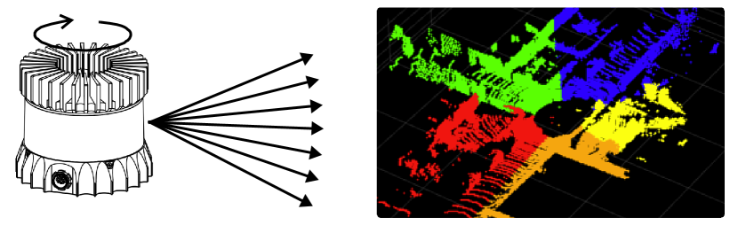
Figure. 1 demonstrates this methodology, illustrating how the beam transmitter and reflecting mirror of mechanical LiDAR systems cover the field of view (FoV) through rotation. Following spherical projection, we segment the LiDAR data frame according to horizontal angular ranges. This procedure involves dividing the range image into equal slices based on predetermined segments to assess the impact of slice size and number on ground segmentation performance. In our experiments, we segment the frame into up to five slices. Our findings aim to provide valuable insights into the scalability and performance enhancements that parallel processing frameworks can offer for LiDAR data analysis.
III-D Result Evaluation
In our experimental framework, we divided the LiDAR data frame into segments ranging from one to five slices. This segmentation was designed to explore the relationship between slice size and the effectiveness of different ground segmentation methods. Our goal is to identify the most efficient strategies for parallel processing of LiDAR data, thereby enhancing computational efficiency and accuracy in segmentation tasks.
A notable trend observed in our study is the performance degradation associated with an increasing number of slices, particularly evident in the Simple Morphological Filter (SMRF) method. As a grid-based approach relies on constructing a minimum elevation surface map for initial point cloud segmentation, SMRF’s performance is significantly compromised by variations in height distribution. These variations become more pronounced under a bird’s-eye view when the data is segmented. Similarly, the performance of the Random Sample Consensus (RANSAC) method deteriorates as additional slices are introduced. This decline is attributed to its dependence on a larger volume of input points for statistical analysis, which becomes less feasible with increased segmentation.
In contrast to our initial expectations, the range image-based Depth Ground method not only maintained robust performance across various slice numbers but also demonstrated improved metrics when the number of slices increased from one to two. This unexpected result suggests that slicing, to some extent, may reduce the complexity of range image-based segmentation tasks within each slice, thereby enhancing their overall effectiveness.
Of all the methods evaluated, the Depth Ground method emerged as the most resilient and consistent, particularly adept at managing data and tasks segmented into multiple slices. This method’s durability underscores the inherent advantages of range image-based approaches in maintaining high accuracy across diverse segmentation conditions. The point-based RANSAC method also showed commendable durability but to a lesser extent, while the grid-based SMRF method was notably more susceptible to adverse effects from the slicing strategy.
IV Real-world Experiment with SSL
IV-A Data Collection
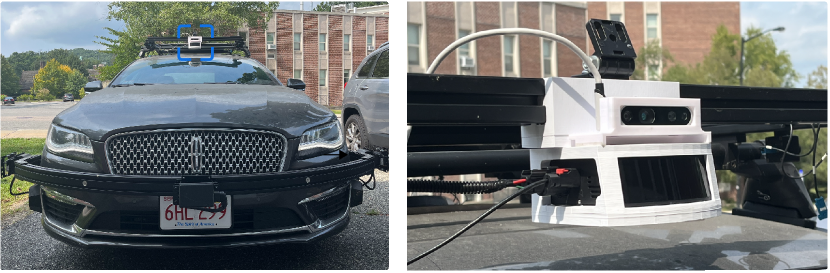
To assess the efficacy and compatibility of our parallel ground segmentation approach with solid-state LiDAR sensors, we established a LiDAR-Camera recording framework designed to capture real-world data. Utilizing a synchronized setup within the Robot Operating System (ROS) at approximately 10 Hz, we achieved coherent data collection between LiDAR and camera sensors. Sensor calibration was conducted using a previously developed method [18], which optimized the alignment and synchronization of data streams, thereby enhancing the accuracy of our real-world testing.
IV-B Frame Segmentation for SSL
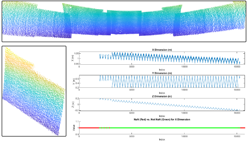
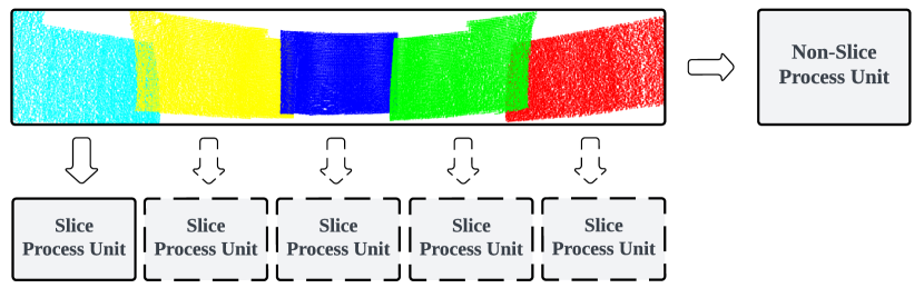
The initial input data was organized in a fixed structure, containing 78,750 points in a single column. Upon detailed analysis shown in Figure. 3, we determined that this data frame was segmented into five uniform subframes, each comprising 15,750 points, as depicted in the accompanying figure. Notably, the points within the subframes were arranged in a zig-zag pattern. To rectify this, we reorganized the even rows and reconfigured each subframe into a 126x125 matrix.
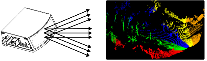
Given the data frame’s natural division into five distinct parts, we implemented a five-slice parallel segmentation. Each subframe underwent range-image-based ground segmentation to assess the method’s efficacy and functionality under real-world conditions, as demonstrated in Figure. 4.
IV-C Result Demonstration
Given the detailed quantitative insights presented in Section III and the significant effort required for manual annotation of point cloud ground truth, we adopted a qualitative approach to demonstrate the effectiveness of our proposed parallel ground segmentation method.
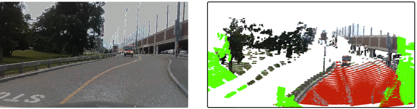
Referencing image data for validation, Figure 5 exemplifies the successful application of our parallel ground segmentation workflow. This method identifies the road plane within a complex environment, leveraging SSL data for precise segmentation outcomes. The detected road is highlighted with red points, while green points represent LiDAR data outside the camera’s field of view (FoV).
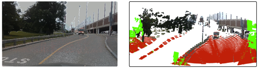
Further illustrating the method’s versatility, Figure 6 demonstrates the segmentation of a grass plane under challenging conditions. With an adapted elevation angle threshold, the grass area, with a slightly higher slope, is accurately identified as part of the ground. Notably, even with occlusions such as a fence, the grass area remains clearly delineated.
These qualitative demonstrations highlight the robustness and precision of our parallel ground segmentation approach, especially in navigating complex environmental challenges. The results offer compelling evidence of the practical applicability and effectiveness of our method in real-world scenarios using SSL sensors.
V Parallel Hardware Architecture
Based on previous experiments, the range image-based method demonstrates superior performance and robustness when employed with a parallel processing mechanism for mechanical LiDAR and SSL sensors in the ground segmentation task. In this section, as shown in Figure. 7, we aim to showcase and validate the advantages of our parallel processing workflow through FPGA implementations. We conducted comparative evaluations between non-sliced and five-slice configurations in single sequential processing mode, as well as under different levels of parallelism.
V-A Range Image LiDAR Ground Segmentation on FPGA
Our experimental designs were adapted from a configurable FPGA implementation IP for depth ground segmentation, previously highlighted as part of our contributions and available through MathWorks222https://www.mathworks.com/help/visionhdl/ug/lidar-ground-segmentation.html. The ground segmentation implementation incorporates the Savitzky-Golay Smoothing module for elevation smoothing within the angular matrix and utilizes a Breadth-First Search (BFS) Ground Labeling module for efficient label propagation.
V-B Implementation Result
We refined our ground segmentation design to function in scenarios both with and without data slicing, as well as across varying levels of parallel computation. This approach aims to highlight the resource efficiency and processing speed benefits of parallel mechanisms on FPGA platforms. The implementation was realized using Matlab’s HDL Coder and Vision HDL Toolbox, specifically with Matlab 2023b and Xilinx 2022.1, targeting the Xilinx xc7z045 FPGA.
Resource Non-Slice PU Slice PU Parallel Slice PUs Slice LUTs 32350 (14.8 %) 31783 (14.54%) 100060 (45.78%) Slice Registers 36472 (8.34%) 35448 (8.11%) 105190 (24.06%) DSPs 26 (2.89%) 26 (2.89%) 78 (8.67%) Block RAM Tile 136 (24.95%) 117.5 (21.56%) 335 (61.47%)
The Non-Slice PU processes the entire frame of SSL data, with a frame size of 126x625. The Slice PU processes five subframes sequentially, each with a size of 126x125. The Parallel Slice PUs deploy three processing units to parallelize the computation
The results of our comparative analysis, detailed in Table. II, reveals that in single processing unit mode, the sliced processing unit outperforms its non-sliced counterpart in terms of resource utilization. This improvement is primarily due to the reduced row length in each subframe, which minimizes the storage and processing demands for intermediate values. On the other hand, when enhancing processing speeds with parallel processing, additional hardware resource is required.
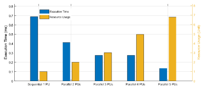
As depicted in Figure. 8, deploying sliced data across multiple processing units exposes a fundamental trade-off between execution speed and resource consumption, including bandwidth and hardware resources. When compared to the CPU execution time for the same frame, which was measured at 6.93 ms, the speed-up achieved varies significantly, ranging from 10.1 to 50.3 times, depending on the degree of parallelism employed.
VI Conclusion
Ground segmentation is a crucial task in point cloud processing. This research introduces an innovative slicing technique for parallel processing within a sliced LiDAR frame on mechanical and solid-state LiDAR sensors, implemented on a paralleled FPGA-based hardware acceleration platform. This approach significantly reduces execution times compared to traditional CPU-based methods. We evaluated our method using the SemanticKITTI dataset and demonstrated its practical application with a Camera-SSL system on our test vehicle. This validated the effectiveness of our parallel processing technique for point cloud ground segmentation via different LiDAR sensors. Consequently, this study not only confirms the feasibility of our method but also suggests a promising direction for the development of parallel processing in LiDAR systems for future applications.
References
- [1] J. Zhang, W. Xiao, B. Coifman, and J. P. Mills, “Vehicle tracking and speed estimation from roadside lidar,” IEEE Journal of Selected Topics in Applied Earth Observations and Remote Sensing, vol. 13, p. 5597–5608, 2020, conference Name: IEEE Journal of Selected Topics in Applied Earth Observations and Remote Sensing.
- [2] I. Bogoslavskyi and C. Stachniss, “Fast range image-based segmentation of sparse 3D laser scans for online operation,” in 2016 IEEE/RSJ International Conference on Intelligent Robots and Systems (IROS), Oct. 2016, pp. 163–169.
- [3] D. Zermas, I. Izzat, and N. Papanikolopoulos, “Fast segmentation of 3d point clouds: A paradigm on lidar data for autonomous vehicle applications,” in 2017 IEEE International Conference on Robotics and Automation (ICRA). IEEE, 2017, pp. 5067–5073.
- [4] Z. Zhou, Y. Zhang, and H. Foroosh, “Panoptic-polarnet: Proposal-free lidar point cloud panoptic segmentation,” in Proceedings of the IEEE/CVF Conference on Computer Vision and Pattern Recognition, 2021, pp. 13 194–13 203.
- [5] N. Li, C. P. Ho, J. Xue, L. W. Lim, G. Chen, Y. H. Fu, and L. Y. T. Lee, “A Progress Review on Solid-State LiDAR and Nanophotonics-Based LiDAR Sensors,” Laser & Photonics Reviews, vol. 16, no. 11, p. 2100511, 2022.
- [6] X. Zhang and X. Huang, “Real-Time Fast Channel Clustering for LiDAR Point Cloud,” IEEE Transactions on Circuits and Systems II: Express Briefs, vol. 69, no. 10, pp. 4103–4107.
- [7] Y. Lyu, L. Bai, and X. Huang, “ChipNet: Real-Time LiDAR Processing for Drivable Region Segmentation on an FPGA,” IEEE Transactions on Circuits and Systems I: Regular Papers, vol. 66, no. 5, pp. 1769–1779.
- [8] J. Cui, J. Niu, Z. Ouyang, Y. He, and D. Liu, “ACSC: Automatic Calibration for Non-repetitive Scanning Solid-State LiDAR and Camera Systems,” Nov. 2020.
- [9] Z. Peng, Z. Xiong, Y. Zhao, and L. Zhang, “3-D Objects Detection and Tracking Using Solid-State LiDAR and RGB Camera,” IEEE Sensors Journal, vol. 23, no. 13, pp. 14 795–14 808, July 2023.
- [10] W. Wei, B. Shirinzadeh, R. Nowell, M. Ghafarian, M. M. A. Ammar, and T. Shen, “Enhancing Solid State LiDAR Mapping with a 2D Spinning LiDAR in Urban Scenario SLAM on Ground Vehicles,” Sensors, vol. 21, no. 5, p. 1773, Jan. 2021.
- [11] K. Li, M. Li, and U. D. Hanebeck, “Towards High-Performance Solid-State-LiDAR-Inertial Odometry and Mapping,” IEEE Robotics and Automation Letters, vol. 6, no. 3, pp. 5167–5174, July 2021.
- [12] M. A. Fischler and R. C. Bolles, “Random sample consensus: a paradigm for model fitting with applications to image analysis and automated cartography,” Communications of the ACM, vol. 24, no. 6, pp. 381–395, 1981.
- [13] T. Chen, B. Dai, R. Wang, and D. Liu, “Gaussian-Process-Based Real-Time Ground Segmentation for Autonomous Land Vehicles,” Journal of Intelligent & Robotic Systems, vol. 76, no. 3, pp. 563–582, Dec. 2014.
- [14] B. Douillard, J. Underwood, N. Melkumyan, S. Singh, S. Vasudevan, C. Brunner, and A. Quadros, “Hybrid elevation maps: 3D surface models for segmentation,” in 2010 IEEE/RSJ International Conference on Intelligent Robots and Systems, Oct. 2010, pp. 1532–1538.
- [15] T. J. Pingel, K. C. Clarke, and W. A. McBride, “An improved simple morphological filter for the terrain classification of airborne LIDAR data,” ISPRS Journal of Photogrammetry and Remote Sensing, vol. 77, pp. 21–30, Mar. 2013.
- [16] I. Bogoslavskyi and C. Stachniss, “Efficient online segmentation for sparse 3d laser scans,” PFG–Journal of Photogrammetry, Remote Sensing and Geoinformation Science, vol. 85, no. 1, pp. 41–52, 2017.
- [17] J. Behley, M. Garbade, A. Milioto, J. Quenzel, S. Behnke, C. Stachniss, and J. Gall, “Semantickitti: A dataset for semantic scene understanding of lidar sequences,” in Proceedings of the IEEE/CVF International Conference on Computer Vision, 2019, pp. 9297–9307.
- [18] Z. Huang, X. Zhang, A. Garcia, and X. Huang, “A novel, efficient and accurate method for lidar camera calibration,” in 2024 IEEE International Conference on Robotics and Automation (ICRA), 2024, pp. 14 513–14 519.