On the Use of Immersive Digital Technologies for Designing and Operating UAVs
Abstract
Unmanned Aerial Vehicles (UAVs) provide agile and safe solutions to communication relay networks, offering improved throughput. However, their modeling and control present challenges, and real-world deployment is hindered by the gap between simulation and reality. Moreover, enhancing situational awareness is critical. Several works in the literature proposed integrating UAV operation with immersive digital technologies, such as Digital Twin (DT) and Extended Reality (XR), to address these challenges. This paper provides a comprehensive overview of current research and developments involving immersive digital technologies for UAVs, including the latest advancements and emerging trends. We also explore the integration of DT and XR with Artificial Intelligence (AI) algorithms to create more intelligent, adaptive, and responsive UAV systems. Finally, we provide discussions, identify gaps in current research, and suggest future directions for studying the application of immersive technologies in UAVs, fostering further innovation and development in this field. We envision the fusion of DTs with XR will transform how UAVs operate, offering tools that enhance visualization, improve decision-making, and enable effective collaboration.
Index Terms:
Unmanned Aerial Vehicles, Digital Twin, Extended Reality, Virtual Reality, Augmented Reality, Mixed Reality, Machine Learning, Reinforcement Learning.| Acronym | Definition |
|---|---|
| A3C | Advantage Actor-Critic |
| AI | Artificial Intelligence |
| AR | Augmented Reality |
| AR-HUD | Head-Up Display |
| AVs | Autonomous Vehicles |
| BCDDPG | Behavior-Coupling Deep Deterministic Policy Gradient |
| CPS | Cyber-Physical Systems |
| DDPG | Deep Deterministic Policy Gradients |
| DL | Deep Learning |
| DRL | Deep Reinforcement Learning |
| DQN | Deep-Q-Network |
| DT | Digital Twin |
| DTN | Digital Twin Network |
| GAN | Generative Adversarial Network |
| IoT | Internet of Things |
| ITS | Intelligent Transportation Systems |
| LSTM | Long Short Term Memory |
| MDP | Markov Decision Process |
| ML | Machine Learning |
| MR | Mixed Reality |
| QoS | Quality of Service |
| RL | Reinforcement Learning |
| TAM | Timed Automaton Machine |
| UAV | Unmanned Aerial Vehicle |
| VR | Virtual Reality |
| XR | Extended Reality |
I Introduction
Unmanned Aerial Vehicles (UAVs-TABLE I), commonly known as drones, have made considerable progress in recent decades [1, 2]. The short, line-of-sight dominant communication link between UAVs and their users, and the ability to optimize mobility, along with cost-effectiveness, and agility, have led to their widespread use as aerial base stations [3], aerial relays [4], and aerial data collectors [5], with continuous technological innovation and adoption in numerous civil and commercial sectors, including public safety [6], energy [7], agriculture [8], environmental monitoring [9], and other sectors[10]. In parallel with the development of UAVs, immersive digital technologies such as Digital Twin (DT) and Extended Reality (XR) have proven to be transformative forces in wireless systems [11, 12].
I-A Motivation and Background
Immersive digital modeling systems such as DT replicate UAV elements, processes, dynamics, and firmware in a digital counterpart. The physical and digital counterparts can share all inputs and operations through real-time data communications[13]. A UAV swarm [14] with different aerial roles [15] can be modeled using DT to enable collaboration, promote safety, and address problems such as the simulation-to-reality gap.
XR can significantly improve the safety of UAVs by using Augmented Reality (AR) to create a 3D map of their surroundings and use it to recognize and track objects in the environment [16]. Moreover, AR can provide navigation and guidance to UAVs, allowing them to move efficiently and safely navigate complex environments. However, the requirements of XR services in terms of mobility, data rate, latency, and reliability increase the demands on UAVs. Therefore, enabling XR services is a critical challenge for UAVs.
We are motivated by the fact that the integration of DTs and XR can be a significant step toward creating immersive digital environments. Integrating DTs with XR allows operators to interact with replicas of UAV assets in real time. For example, for a UAV swarm, operators can step into a virtual swarm, examine environmental elements, and assess potential changes in swarm parameters without the need for physical presence on-site. A salient aspect of merging XR with DTs is enhanced decision-making, where operators can visualize complex data overlaid within the XR environment, making it easier to understand and act upon. This is especially useful in environments that are complex or dangerous to access physically, such as harsh and remote areas.
We aim to review the literature and clarify how we can utilize DTs to develop precise modeling and control, efficient UAV cooperation, rigorous safety measures, and strategies to bridge the gap between simulations and real-world applications to facilitate UAV operation effectively. We will also characterize how we can utilize XR technologies to enhance the effective operation of UAVs by improving their environmental perception, navigation capabilities, obstacle detection, response to unpredictable scenarios, and facilitating human operator monitoring and intervention.
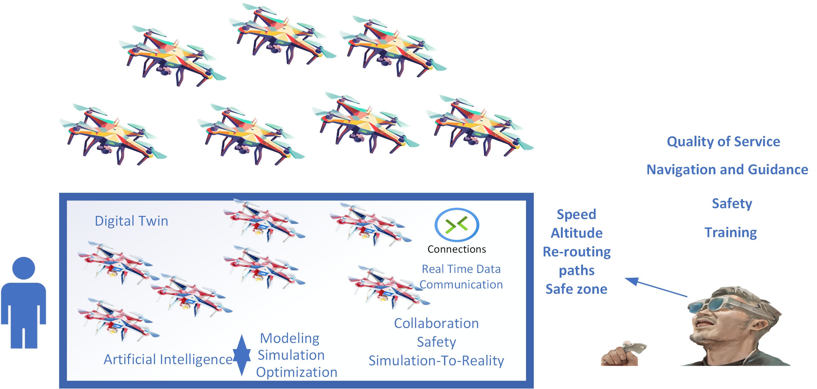
Fig. 1 depicts an overview of the UAV swarm management system, which integrates state-of-the-art DT, AR, and AI technologies. At the bottom of the figure is a DT, a virtual replica of the UAV swarm that uses AI to optimize and control the behavior of the swarm. The DT monitors the entire life cycle of the UAV swarm, ensuring efficient and intelligent cooperation between the UAVs. Moreover, it integrates the human view with AR and overlays relevant information for live feedback for flight monitoring and control. This information includes altitude, speed, dynamic re-routing paths, proximity warnings, and safety zones around each UAV to maintain separation and avoid collisions within the swarm.
I-B Existing Surveys and Tutorials
In the literature, a few works consider immersive digital technologies. The authors of [17] present an overview of AR research in robotics over five years, categorizing the literature into Medical Robotics, Motion Planning and Control, Human-Robot Interaction, and Multi-Agent Systems. The authors of [18] provide a thorough review of DT technology for Intelligent Transportation Systems (ITSs), with a particular focus on electric vehicles (EVs) and autonomous vehicles (AVs). The authors of [19] present a comprehensive review of 31 VR-based studies on AV-pedestrian interaction. The authors of [20] present a systematic review of AR visualizations for in-vehicle driver communication from 2012 to 2022. The authors of [21] survey the use of DT technology for ITSs, focusing on EVs and AVs. The authors of [22] present a review encompassing 12 years of VR research in the context of automated driving, from 2009 to 2020. The authors of [23] review the current development stage of the Internet of Vehicles and Digital Twins.
The authors of [24] survey the conjunction of AI, UAVs, and digital twin technology, and investigate AI algorithms, learning models, and data processing techniques that enable UAVs to perceive, learn, and make informed decisions. The authors of [25] provide a survey to highlight the applications of DTs in UAVs and overview the specific tools used for DT implementation in the UAV domain. The authors of [26] explore the concepts and potential of DT networks, with a particular focus on the role of machine and deep learning in improving the efficiency of Digital Twin Network (DTN) systems. The authors of [27] investigate the key roles that control theory and DTs play in improving the performance of quadrotor UAVs. The authors of [28] present a review of UAVs and how LiDAR and VR/AR Technology based on cloud computing architecture can accelerate the mine planning activity.
I-C Contribution
In this paper, we review the literature on the applications of immersive digital technologies in UAVs. As opposed to the surveys referred in the previous section, we specifically explore the role of DT in UAV modeling and control, designing collaboration, and improving safety and QoS. We also look at the integration of DT with ML techniques and its key role in facilitating their applications in UAVs. Moreover, we examine the role of XR in enhancing situational awareness, supporting operator training, and improving the navigation capabilities of UAVs. Overall, we provide a comprehensive review and novel insights into the intersection of DT, XR, and AI technologies for designing and operating UAVs, offering practical recommendations for future research and development.
The contributions of this paper are listed as follows:
-
•
We provide a detailed review of existing literature on DT applications in UAVs, highlighting its role in simulation, safety enhancement, and operational optimization. We emphasize how DT technology addresses the challenge of transferring AI models and simulations into practical UAV applications, and underscore DT’s role in improving UAV safety by providing high-fidelity simulations that facilitate thorough testing and validation of algorithms under diverse conditions. We also identify research gaps and opportunities for future exploration, particularly in optimizing DT frameworks for UAV operations, improving AI integration, and expanding application scenarios.
-
•
We showcase how XR technologies are seamlessly integrated into UAV operations, offering transformative benefits across training, navigation, and situational awareness, discuss practical challenges in implementing XR solutions in UAV contexts and propose strategies to optimize operational efficiency and safety. We also highlight future research and development efforts toward maximizing the potential of XR technologies in advancing UAV capabilities.
-
•
We thoroughly examine the integration of DT and XR with AI and ML algorithms to create more intelligent, adaptive, and responsive UAV systems. We enhance user interaction and situational awareness by integrating DT and XR technologies, such as AR and VR, with AI, allowing operators to visualize and interact with UAV data in immersive environments.
I-D Paper Structure and Organization
In Section II, we investigate DT technology in the context of UAVs, discussing its integration with Deep Reinforcement Learning (DRL) and exploring various use cases. We also present the key findings and insights. In Section III, we focus on the transformative role of XR in UAVs, examining its impact on path planning, collision avoidance, situational awareness, and other functionalities. We also conclude this section with key findings and insights. In Section IV, we highlight future directions for research on DT and XR in the context of UAVs, providing a roadmap for further studies. Finally, we conclude the paper in Section V.
| Paper | Objective | ML Models | Scenario | Objective Function |
|---|---|---|---|---|
| [29] | To control the behavior of the UAV swarm | DNN | Cooperation / UAV swarm | Channel Throughput |
| [30] | To enable the application of DRL in the real world | DDPG | Flocking Motion / UAV swarm | Collision avoidance / Connectivity maintenance / Approaching target |
| [31] | To solve the trade-off between training speed and environmental fidelity | QMIX | Cooperative Search / UAV swarm | Target reward / Cognitive reward / Coverage reward |
| [32] | To overcome the challenge from simulation to reality | DDPG | Path planning / UAV swarm | Connectivity maintenance / Collision avoidance / Task completion |
| [33] | To overcome the constraints of the RL exploration phase | DQN | Path planning / UAV | Energy consumption |
II Exploring Digital Twins in UAVs: Simulation, Safety, and Beyond
This section reviews the literature on DT in the context of UAVs. We highlight the importance of DT in UAVs and its role in addressing simulation-to-reality problems and improving safety in UAVs. Table II provides a comparative summary of recent research papers that explore the application of DT in various UAV scenarios, utilizing different ML models. Each study employs specific ML models, such as DNN and DDPG (Table I), to address unique challenges within their respective scenarios. For instance, some papers focus on enhancing cooperative behavior and collision avoidance in UAV swarms.
II-A Preliminaries
DT was proposed by Grieves in 2003 [34] and was one of Gartner’s ten most promising technology trends for 2018[35]. In addition, it enjoys great popularity as a multi-physics, multi-scale, and ultra-fidelity simulation that reproduces the state of a corresponding twin in real time based on historical data, real-time sensor data, and physical models, which offers remarkable opportunities for many industrial applications. The DT technology is integrated with the UAVs to improve UAV design, traffic optimization, QoS, and safety [36].
Meanwhile, in UAVs, the complexity of real-world scenes makes it difficult to create a simulation environment with a high degree of accuracy. Moreover, the models learned by AI algorithms from simulated environments are difficult to deploy in practice without extensive processing. In summary, the gap between simulation and reality severely limits the application of AI to UAVs.
The advent of DT technology offers a new direction for solving the above problems. Once a DT is synchronized with its corresponding real twin, it contains accurate system state information, which is exactly what the learning process requires. The AI model can learn from DT and be quickly put into practice with the help of DT. The high-fidelity simulations enable extensive testing and validation of algorithms under different scenarios and conditions [32, 37].
Improving safety is a primary concern in UAVs. By using DT technology, which creates a virtual replica of UAVs, we can gain better control over the UAV and its operation. With this technology, we can thus navigate better and handle complex scenarios, which significantly improves overall safety.
AI, in turn, can provide advanced analytics and decision-making capabilities, enabling UAVs to self-optimize, self-configure, and self-heal [38, 39]. DTs and AI are expected to play crucial roles in developing and deploying UAVs. Integrating DTs and AI provides a powerful approach to the modeling, simulation, and optimization of UAVs [40, 41]. In scenarios such as UAV navigation and trajectory planning, DTs can be used with ML models and build predictive models [42]. The use of DT for UAVs is particularly motivated by the design and operation of innovative services with guaranteed Quality of Service (QoS).
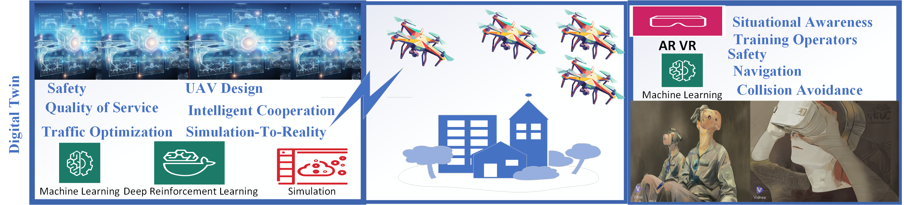
Fig. 2 highlights DT contributions for UAVs. DT improves safety, optimizes traffic through efficient routing and dynamic adjustments, and enhances service quality by tracking performance metrics. It also helps with UAV design by simulating configurations and bridging the gap between simulation and reality with accurate modeling and continuous feedback. Furthermore, DT facilitates intelligent cooperation within UAV swarms.
II-B Literature Review
II-B1 Path Planning and Navigation
The authors of [33] formulate path planning and visiting targets as an optimization problem and propose a DRL strategy to learn target patterns while minimizing UAV time and energy overhead. They develop a DT based on the Gazebo simulator to overcome the constraints of the reinforcement learning (RL) exploration phase and verify the feasibility of such a framework by developing a real testbed. Building on this idea, the authors of [32] study path planning for UAVs. A DT-based DRL training system is proposed to overcome the challenge of moving from simulation to reality. The DT facilitates the application of the DRL model to real UAVs. A DDPG-based multi-UAV path planning algorithm is used in the training phase, and LSTM is employed to understand better various state information in a multi-UAV path planning task. Similarly, the authors of [43] study a UAV visual navigation system based on DT. A visual UAV navigation system based on DT integrating DT, UAV, and DL is proposed and realized. The approach can address real-world data collection challenges and monitor UAVs in the physical environment. It helps to expand the application scenarios of UAVs and improve the performance and safety of UAVs in performing tasks.
Moreover, the authors of [30] study flocking motion for UAV swarms and use DRL to realize it. A DT based on the DRL training framework is proposed to solve the practical problems of DRL applications. DT is incorporated into the central system to train the DRL model. After training, the DRL model can be quickly used in the real UAV through the connections between the physical and digital units. The DRL algorithm used is from the family of actor-critic named behavior-coupling deep deterministic policy gradient (BCDDPG). This scheme enables the application of DRL in the real world.
Lastly, the authors of [44] address the challenge of task offloading and resource allocation in a DT-empowered UAV-assisted MEC network with user mobility and use the adaptive DT framework to anticipate the dynamic network environment properly. DT assists in improving mobile users’ cooperation with each other. They provide secured task offloading and resource allocation techniques based on federated reinforcement learning (FRL) for the DT-empowered UAV-assisted MEC system. FRL consists of multiple UAVs equipped with MEC servers and multiple resource devices, where the mobile users randomly generate computing tasks as they move. Table III summarizes the above findings.
| Ref | Technique | Application | Strengths and Limitations |
|---|---|---|---|
| [33] | DRL with DT | Path planning and target visiting | Minimizes time and energy overhead; verified on real testbed. |
| [32] | DT-based DRL | Multi-UAV path planning | Facilitates simulation to improve understanding of multi-UAV tasks. |
| [43] | DT-based Visual Navigation | UAV visual navigation | Integrates DT, UAV, and DL; addresses real-world data collection challenges; improves performance and safety. |
| [30] | DRL with DT using BCDDPG | Flocking motion for UAV swarms | Solves practical DRL application problems; DT trains DRL model centrally, enabling rapid deployment in real UAVs. |
| [44] | FRL for DT-empowered UAV-assisted MEC | Task offloading and resource allocation | Secured task offloading and resource allocation using federated reinforcement learning; enhances cooperation among mobile users in dynamic environments. |
II-B2 UAV Swarm
The authors of [31] study the cooperative search for static targets by multiple UAVs with limited sensing range and communication capability in a dynamic threat environment, and propose a new multi-agent DRL method to solve the problem of cooperative target search by multiple UAVs. A centralized DT training framework with decentralized execution capability is also proposed, which can facilitate the continuous development of DRL models and solve the trade-off between training speed and environmental fidelity when DRL is applied to a UAV swarm. In parallel, the authors of [29] study the UAV swarm to enable its intelligent cooperation through the latest AI achievements. A new DT is proposed to allow for intelligent cooperation among UAV swarms. The DT is a virtual replica of the UAV swarm to monitor its life cycle. It is integrated with an ML algorithm to find the global optimal solution and control the behavior of the UAV swarm. Moreover, the authors of [45] argue that the temporal constraints of UAV swarm can lead to a poor ratio in task performance. In this context, a DT and DRL-based task assignment method is proposed. The proposed task assignment includes two phases: initial task assignment and task reassignment. In the initial task assignment, the airship uses a genetic algorithm to divide a task into multiple subtasks according to the shortest distance and assign them to UAVs. In task reassignment, the decision on the UAV’s behavior is made by DRL based on DT to reassign the task and improve the task completion while respecting the time constraint. Table IV summarizes the above findings.
| Ref | Technique | Application | Strengths and Limitations |
|---|---|---|---|
| [29] | DT with ML | Intelligent cooperation among UAV swarms | Integrated with ML for optimal solution. |
| [45] | DT and DRL-based task assignment | Task assignment for UAV swarms | DRL for reassignment; respects time constraints. |
| [31] | Multi-agent DRL with DT | Cooperative target search by multiple UAVs | Balances training speed and fidelity. |
DT focuses on creating accurate and dynamic digital replicas for analysis and optimization and can improve the functionality of UAV swarms by addressing flocking motion, cooperative search, navigation, and enabling intelligent cooperation. XR extends this concept by providing immersive and interactive environments that can significantly enhance user interaction and situational awareness.
II-C Key Findings and Insights
To effectively facilitate the operation of UAV swarms, there is an urgent need for precise modeling and control, efficient UAV cooperation, rigorous safety measures, and strategies to bridge the gap between simulations and real-world applications. However, existing technologies fail to fulfill these objectives. Immersive technologies like DTs can effectively realize these goals. DTs are critical for modeling and controlling the behavior of UAV swarms, enabling intelligent cooperation among UAVs, improving performance and safety, and overcoming real-world data collection and monitoring challenges. In conjunction with RL, they facilitate the development of DRL and address simulation-to-reality challenges during the exploration phase.
The integration of DRL with DT can optimize path planning and target visiting for UAVs, minimizing time and energy expenditure while verifying feasibility in a real test environment. In addition, a DT-based DRL system improves multi-UAV path planning by facilitating the transition from simulation to reality by using DDPG and LSTM models to improve task understanding and implementation in real UAVs. In addition, a DT-based visual navigation system for UAVs addresses the challenges of data acquisition in the real world. It integrates DT, UAV and DL to improve performance and safety in various application scenarios. Moreover, implementing a DT-based DRL framework for UAV swarm motion solves practical DRL application problems and enables rapid deployment in real UAVs using the BCDDPG algorithm. Similarly, FRL in DT-based UAV-assisted MEC networks improves task distribution and resource allocation, thereby enhancing collaboration between mobile users in dynamic environments. Finally, a multi-agent DRL method within a centralized DT framework improves the cooperative target search of UAVs and balances training speed and environmental fidelity for continuous DRL model development.
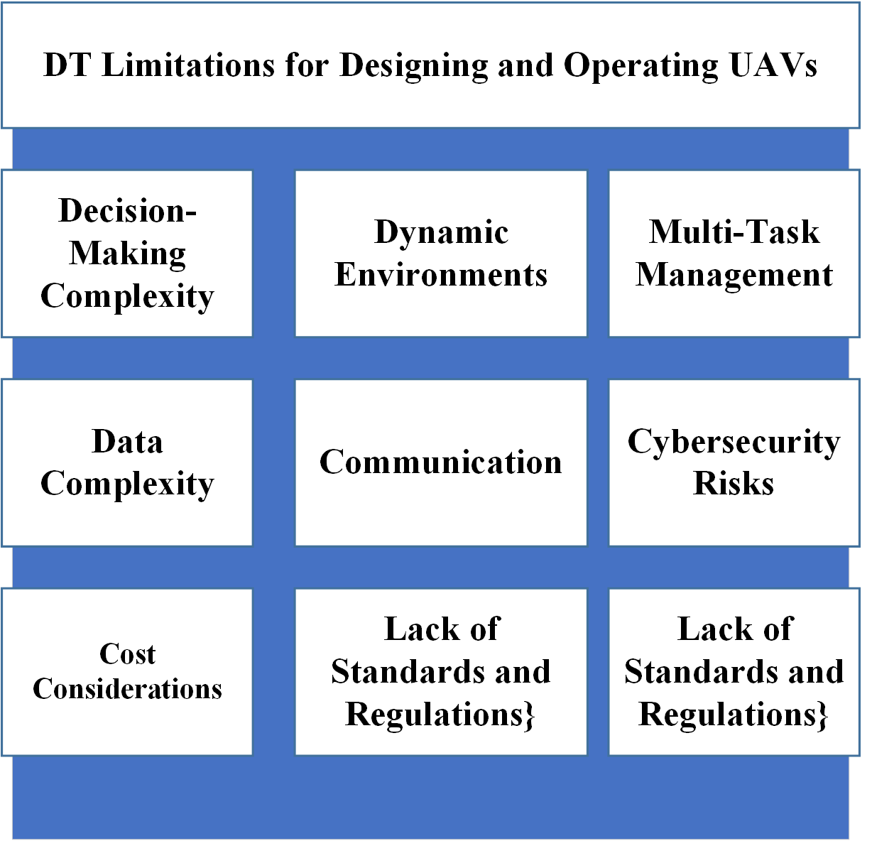
Over the past decade, UAVs have led to unprecedented advancements in monitoring and surveillance. Among these innovations, the evolution of DT-assisted UAV has proven to be a game-changer, revolutionizing UAV modeling and control. DTs are crucial in enabling real-time optimization, monitoring, and control of UAV swarms by swarm operators. These systems significantly enhance the functionality of UAV swarms by tackling complex challenges such as flocking motion, cooperative search, navigation, and fostering intelligent cooperation among swarm members. However, DTs suffer some limitations and risks that need to be addressed to unlock their potential, as shown in Fig. 3. These limitations include decision-making complexity, data complexity, dynamicity of environments, complex tasks, cost, lack of standards and regulations, communication, and cybersecurity risks[46]. In the following, we elaborate on each challenge:
-
1.
Decision-Making Complexity In the DT environment, ML models support decision-making and maintenance strategies, process optimization, and resource allocation by analyzing data and learning from trends. DTs collect network data, reconstruct the network environment, and provide the basis for training ML models. DRL models provide solutions for network decision-making based on real-time network status and empirical data.
-
2.
Data Complexity DRL models require training data to develop and produce precise predictions. Gathering sufficient and representative training data can be challenging, especially for systems with limited historical data. Addressing data scarcity issues may require operators to explore techniques such as data augmentation or synthetic data synthesis.
A) Data Integration DTs collect network data, reconstruct the network environment, and provide the basis for training ML models. Seamless data flow between DTs and DRL models necessitates the implementation of appropriate data integration mechanisms.
B) Data Accuracy Ensuring the accuracy, consistency, and reliability of the data used by DRL models is crucial. Operators must guarantee these aspects when utilizing data collected from sensors and other sources.
-
3.
Dynamic Environments Designing DTs that remain robust across different environments adds another layer of complexity. UAVs operate in rapidly changing environments, requiring DTs to be adaptable and responsive to real-time changes. Also, managing interactions with environmental objects and other UAVs is essential to maintain smooth operations.
-
4.
Multi-Task Management Task Coordination UAVs may need to perform multiple tasks simultaneously or coordinate with other UAVs or environmental objects. DTs capable of managing such complexities and interactions effectively require advanced modeling, simulation capabilities, and integration with ML.
-
5.
Cost Considerations Developing and maintaining DTs can be costly, necessitating careful consideration of budget and resource allocation. DT-based DRL systems improve training efficiency and cost efficiency in resource management.
-
6.
Lack of Standards DT technology is poised to revolutionize the UAV industry by enhancing design, development, and operational processes. Key technologies driving this transformation include modeling, data management, connectivity, and communication. As DT concepts and technologies mature, establishing comprehensive standards is essential to ensure clarity and quality assurance and promote effective implementation within the UAV sector[47].
-
7.
Communication Ensuring robust and secure communication channels between UAVs and DTs is crucial for real-time data exchange and control. 5G communication links ensure reliable and low latency communications with improved capacity, thereby appearing as a practical option for communication between UAVs and DTs. Millimeter wave (mm-Wave) can provide more abundant frequency resources than the microwave band, and a much higher achievable rate can be guaranteed to support UAV services such as video surveillance, hotspot coverage, and emergency communications[48]. Also, mm-Wave Communications frequencies have great potential to fulfill the requirements for future high-speed communication links between UAVs and DTs.The UAVs can conduct flexible mmWave beamforming to overcome the high path loss caused by the long propagation distance.
-
8.
Cybersecurity Risks Protecting DTs and UAV systems from cyber threats is vital to ensure the integrity and safety of operations. Considering the wireless nature of real-time communications between UAVs and DTs, the communication links between them are prone to data transmission link attacks, comprising availability, integrity, and confidentiality ones. For example, in jamming and GPS spoofing attacks, the attackers interrupt the communication link between the UAV and the DT[49]. ML-based countermeasures enable UAVs to adaptively exploit wireless system resources while guaranteeing secure operation with DTs in real-time [50].
| Paper | Objective | Solution |
|---|---|---|
| [51] | To enable the operator to make informed decisions | Combining AR technology and vision-based navigation are combined to develop an auxiliary navigation method. |
| [52] | To produce aerial reconstructions of an area of interest | Proposing AR-assisted navigation and flight planning of micro-air vehicles. |
| [53] | Finding the path and locating the objects using UAVs | Developing a user interface based on AR technology for UAV manipulation and path planning. |
| [54] | Improving safety over a manual control interface | Proposing an open-source platform for 3D flight path planning in VR. |
| [55] | Addressing the navigation, path planning, and crash probability of UAVs | Developing a VR technology mixed with web technology. |
| [56] | Finding Way for UAV route planning and self-control in the UAV flight process | Using the UAV virtual platform to collect a large amount of training data and images. |
| [57] | Overcome the disadvantages of the UAV control method and solve the problems of training UAV pilots | Developing a virtual flight environment based on VR technology. |
| [58] | Multi-person UAV swarm control that can operate simultaneously with low-latency | Using VR controllers and head-mounted displays to control UAVs, leading to a solution to the problem of multiple UAVs competing for network resource allocation |
| [59] | UAV pilot training and evaluation to facilitate the learning process of UAV piloting | Enabling a user can make informed decisions about controlling a UAV based on images captured by the camera and enriched with virtual content displayed on a screen. |
| [60] | Evaluate the usability of VR interfaces used to control UAVs | Working with UC Berkeley’s Immersive Semi-Autonomous Aerial Command System (ISAACS) project by experimenting with new ways for humans to interact with UAVs in a VR environment |
| [61] | To improve situational awareness of UAVs with medium altitude and long endurance in reconnaissance missions | The AR system with two functionalities: The route orientation function is responsible for predicting the next waypoint and the further path of the UAV. The target identification function is responsible for quickly locating the target |
| [62] | Collision avoidance and UAV swarm control for an environment with hovering objects | Proposing DRL-based solution along with a new AR technology with a wearable tactile device for human-UAV interaction. |
| [63] | Allow ground station operators to observe real-time information about the aircraft’s attitude, position, and operational status | Proposing a data-driven UAV ground station, AR display, and control system |
| [64] | Traditional radio-based information exchange between humans during emergency operations suffers from a lack of visualization and often leads to miscommunication | Using the location-based AR paradigm to geotag, share, and visualize information. |
| [65] | Reconstruct a 3D map by UAV to show its surroundings | Developing a new AR interface based on Microsoft HoloLens 1 |
| [65] | Address human detection in natural disaster areas using UAVs | Proposing an architecture for search and rescue missions uses a mixed-reality interface to improve location determination and video streaming. |
III Extended Reality Revolutionizing UAVs: Navigating Paths and Enhancing Awareness
This section examines the transformative role of XR technologies in UAVs. We examine the role of XR in path planning and navigation and highlight its role in training and control. Finally, we examine the contributions of XR to situational awareness, collision avoidance, safety, and surveillance. Table V provides a comparative summary of recent research examining the application of XR technologies in various UAV scenarios. The table shows how different studies utilize AR and Virtual Reality (VR) technologies to address various challenges such as UAV navigation, path planning, pilot training, situational awareness, and collision avoidance. For example, some papers focus on improving operator decision-making through AR-based navigation systems, while others propose VR platforms for improved flight path planning and UAV swarm control.
III-A Preliminiries
XR technologies, including VR and AR, play a transformative role in improving the functionality of UAVs. These transformative technologies pave the way for the next generation of UAVs. AR strives to combine computer-generated information with real-world scenes. It can provide an accurate and efficient secondary interface, enabling efficient decision-making and improving situational awareness. Similarly, the immersive nature of VR technology plays a key role in providing a holistic perspective on real-time scenarios, effectively training operators, and improving safety parameters. This technology can enrich human-UAV interaction.
XR requires powerful, flexible, scalable, and efficient systems that leverage ML and AI to perform complex end-to-end optimizations that deliver the expected Quality-of-Experience (QoE) and satisfactory CAPEX/OPEX for UAVs [66]. ML algorithms can be applied to XR to analyze and interpret complex data from the virtual or augmented environment, learn from it, and make intelligent decisions. This integration of ML with AR and VR technologies can improve mission success rates and the effectiveness of UAV missions. Therefore, exploring and advancing XR technologies in conjunction with ML represents a critical step forward in addressing the complex challenges of UAVs.
Fig. 2 highlights XR contributions for UAVs. XR for UAVs enhances situational awareness by providing immersive visualizations, improves operator training through realistic simulations, and increases safety with augmented real-time data. It boosts mission success rates with better planning, aids in navigation and collision avoidance using detailed overlays, and supports efficient decision-making with intuitive interfaces and actionable insights.
III-B Literature Review
III-B1 Path Planning and Navigation
The authors of [51] aim to enable the operator to make informed decisions about future problems and increase the success rate of UAV missions. In this regard, they combine AR technology and vision-based navigation to develop an auxiliary navigation method that is an immersive navigation interface with virtual navigation and decision-making information superimposed on video of the real environment. Similarly, the authors of [52], study micro-air vehicles equipped with high-resolution cameras and can produce aerial reconstructions of an area of interest. In this context, flight path planning cannot replace humans in the loop. Therefore, AR-assisted navigation and flight planning of micro-air vehicles is proposed to complement the user’s view with relevant information for flight planning and live feedback for flight monitoring.
In addressing challenges in UAV path planning and object location, the authors of [53] advocate for an AR-based user interface tailored for indoor manufacturing facilities. This interface minimizes errors and collision risks by enhancing spatial awareness and facilitating intuitive UAV control amidst obstacles.
In another domain, the authors of [54] present an open-source platform for 3D flight path planning in VR and compare its performance with existing UAV pilot interfaces. The VR technology improves safety over a manual control interface and efficiency over a 2D touchscreen interface. Furthermore, the authors of [55] develop a VR technology mixed with web technology to address UAVs’ navigation, path planning, and crash probability. It enables operators to gain practical knowledge of UAVs before they are deployed. The VR environment was reconstructed based on real-world airborne data, and path planning and navigation was performed. Moreover, the authors of [56] use the UAV virtual platform to collect a large amount of training data and images, which can effectively allow UAV route planning and self-control in the UAV flight process cost-effectively. The developed UAV DL (Table I) virtual reality system can generate a large amount of training data and improve the training efficiency of AI systems. Table VI summarizes the above findings.
| Ref | Technique | Application | Strengths and Limitations |
|---|---|---|---|
| [51] | AR-based Navigation | Informed decision-making for UAV missions | Combines AR with vision-based navigation; immersive interface with virtual info superimposed on real environment. |
| [52] | AR-assisted Navigation | Flight path planning for micro-air vehicles | Enhances user view with relevant info for flight planning and monitoring. |
| [53] | AR-based Interface | Path planning in indoor facilities | Minimizes risk of errors and collisions; aids UAV manipulation in complex environments. |
| [54] | VR-based Platform | 3D flight path planning | Improves safety over manual control; more efficient than 2D interfaces. |
| [55] | VR with Web Technology | Navigation and path planning | Enables practical knowledge; real-world data for accurate path planning. |
| [56] | UAV DL Virtual Reality | Training data collection and route planning | Generates large amounts of training data; improves AI training efficiency. |
III-B2 UAV control and training
As described in what follows, XR has been used for UAV control and training.
Authors in [57] overcome the disadvantages of the UAV control method and to solve the problems of training UAV pilots, a virtual flight environment based on VR technology is being developed. VR technology is used to merge dynamic images from the UAV camera with the geographic data information generated by the computer on the ground. Similarly, the authors of [59] develop a new AR application for UAV pilot training and evaluation to facilitate the learning process of UAV piloting. In this application, the user can make informed decisions about controlling a UAV based on images captured by the camera and enriched with virtual content displayed on a screen. In addition, the authors of [58] develop a VR-based approach to multi-person UAV swarm control that can operate simultaneously with low-latency 5G infrastructure. The authors use VR controllers and head-mounted displays to control UAVs, solving the problem of multiple UAVs competing for network resource allocation. Moreover, The authors of [60] evaluate the usability of VR interfaces used to control UAVs through working with UC Berkeley’s Immersive Semi-Autonomous Aerial Command System (ISAACS) project by experimenting with new ways for humans to interact with UAVs in a VR environment and focusing on the UAV mission planning phase and on creating an onboard experience for new users. Table VII summarizes the above findings.
| Ref | Technique | Application | Strengths and Limitations |
|---|---|---|---|
| [57] | VR-based Environment | UAV control and pilot training | Merges UAV camera images with geographic data; overcomes control method disadvantages. |
| [58] | VR-based Approach | Multi-person UAV swarm control | Uses VR controllers and head-mounted displays; operates with low-latency 5G; solves network resource allocation issues. |
| [59] | AR Application | UAV pilot training and evaluation | Facilitates learning process; enriches images with virtual content. |
| [60] | VR Interfaces | Control and mission planning | Evaluates usability; experiments with new interaction methods; focuses on onboarding experience. |
III-B3 Situational Awareness
The authors of [61] propose the AR system with two functionalities to improve situational awareness of UAVs with medium altitude and long endurance in reconnaissance missions. The route orientation function is responsible for predicting the next waypoint and the further path of the UAV. The target identification function is responsible for quickly locating the target. In a related vein, the authors of [62] propose DRL-based collision avoidance and UAV swarm control for an environment with hovering objects, along with a new AR technology with a wearable tactile device for human-UAV interaction. The visualized trajectory and haptic feedback enable the user to predict the UAV’s trajectory. DRL approach makes interaction safe. Similarly, the authors of [63], develop a data-driven UAV ground station, AR display, and control system, and evaluate their performance in a quadrotor flight experiment. The developed AR technology uses the UAV’s telemetry data and video images and merges them to allow ground station operators to observe real-time information about the aircraft’s attitude, position, and operational status. Moreover, a new partnership between humans and UAVs in emergency operations is essential.
Traditional radio-based information exchange between humans during emergency operations suffers from a lack of visualization, often leading to miscommunication. Furthermore, the authors of [64], use the location-based AR paradigm to geotag, share, and visualize information. This paradigm aims to support bidirectional communication between humans and UAVs and to visualize information about the scene relevant to the rescue team’s role. Additionally, the authors of [65], develop a new AR interface based on Microsoft HoloLens 1. HoloLens is a head-worn mixed reality device that interacts with the autonomous UAV. The UAV can reconstruct a 3D map showing its surroundings. This map is then displayed on the AR interface and can be edited and rendered by the user. Moreover, the authors of [67] address human detection in natural disaster areas using UAVs. An architecture for search and rescue missions uses a mixed-reality interface to improve location determination and video streaming. Table VIII summarizes the above findings.
Lastly, in the context of security, the authors of [68] address information leakage in the usage of UAV-aided AR systems with wireless communications. They designed a UAV-aided covert communication system where one UAV transmits the covert message to ground receivers, and a cooperative UAV performs as a jammer to interfere with the malicious eavesdropper, to protect private information for cooperative AR users, with which users can transmit covert information, avoiding being monitored.
| Ref | Technique | Application | Strengths and Limitations |
|---|---|---|---|
| [53] | AR System | Situational Awareness | Improves situational awareness; route orientation predicts waypoints; target identification locates targets. |
| [54] | DRL-based Collision Avoidance | Collision Avoidance and UAV Swarm Control | Safe interaction with AR and haptic feedback; visualized trajectory prediction. |
| [55] | Data-driven Ground Station and AR Display | UAV Control | Real-time UAV telemetry and video information; improves situational awareness. |
| [56] | Location-based AR | Emergency Operations | Geotags and visualizes information; supports bidirectional communication. |
| [57] | AR Interface with HoloLens 1 | UAV Control | 3D map reconstruction and display; user interaction and editing. |
| [58] | Mixed-Reality Interface | Search and Rescue | Improves location determination and video streaming. |
| [59] | UAV-Aided Covert Communication | Information Leakage Prevention | Covert communication to protect private information; uses UAVs for transmission and jamming. |
III-C Key Findings and Insights
XR technologies can integrate data and improve operator situational awareness and safety. In conjunction with ML techniques, intelligent and dynamic decision-making is enabled, based on real-time environment analysis. XR technologies contribute to the successful execution of UAV missions by providing a digital representation of the real world that enables the operator to anticipate and promptly respond to threats. XR Technologies can also contribute to the effective operation of UAVs. The UAVs require a detailed understanding of their environment to operate safely and efficiently. Using XR can improve the UAV’s perception of its surroundings and help it navigate complex routes, detect obstacles, and respond to unpredictable scenarios. In addition, XR can help the human operator monitor the vehicle’s status and its interactions with the environment and intervene when necessary. VR technologies provide an immersive environment for training by presenting realistic situations and challenges that operators may encounter. AR and VR technologies can significantly improve safety for operators and in a broader context, such as traffic safety in UAVs.
AR technology combined with vision-based navigation provides an immersive interface that superimposes virtual information on real environments, aiding informed decision-making and improving UAV mission success rates. Additionally, AR-assisted navigation for micro-air vehicles enhances the user’s view with relevant information for flight planning and live feedback, which is critical for effective flight path planning and monitoring. Furthermore, VR technology improves UAV flight path planning, providing better safety and efficiency compared to manual control and 2D touchscreen interfaces. A VR-based approach for multi-person UAV swarm control, leveraging low-latency 5G, resolves network resource allocation issues and enhances the operator experience. Moreover, an AR application for UAV pilot training facilitates the learning process by enriching real-time images with virtual content, aiding informed decision-making. In addition, DRL-based collision avoidance combined with AR and haptic feedback allows safe interaction and trajectory prediction, improving UAV swarm control in environments with hovering objects. A data-driven UAV ground station with an AR display merges real-time telemetry and video data, significantly enhancing situational awareness for ground operators. Lastly, a UAV-aided covert communication system with AR prevents information leakage by using a cooperative UAV to jam malicious eavesdroppers and protect private data.
XR seeks to use computer-generated virtual environments to enhance and extend people’s skills and experiences, enabling them to use their abilities of understanding and discovery more effectively. ML can improve these capabilities and is used to recognize patterns in the data generated by XR. It can operate in both non-interactive and interactive modes. In the non-interactive mode, the results of XR are fed into the ML to recognize the patterns. In the interactive mode, the data generated by XR is fed into the AI to recognize the patterns and then return the results to XR [69]. XR can address the following challenges for UAVs:
-
1.
XR can improve specialized UAV operations, e.g. search and rescue missions. XR provides rescuers with long-distance navigation capabilities and indicates the direction in which they can reach a search and rescue target. XR improves situational awareness and can be used to display real-time data about environmental conditions, such as obstacles that need to be avoided.
-
2.
In UAV operations such as training pilots using XR, ML should be used in interactive mode to receive XR-generated data, identify patterns, and help participants have a wider range of experiences.
-
3.
Designing a UAV capable of performing complex tasks is very challenging. The main issues include modeling the UAV’s interaction with the environment and enabling the UAV to adapt to new situations. In practice, managing these issues is difficult. Training ML agents for UAVs requires substantial training data, which is hard to capture in the real world. Therefore, training and testing ML in virtual environments is a feasible solution. UAVs can be trained entirely in virtual environments and successfully deployed in the real world[69].
XR can be used to improve situational awareness. XR can bring merits to UAV operations such as search and rescue and provide long-distance navigation capabilities to rescuers, and its integration with ML can help to recognize patterns in the data generated by XR. XR can facilitate UAV design in complex tasks.
IV Future Trends and Research Directions
We investigate immersive digital technologies such as DT and XR in conjunction with UAVs. These technologies can enable better modeling and control of UAVs, improve the UAV’s perception of its surroundings, and enhance responsiveness in critical situations. However, several opportunities remain to advance DT and XR further with UAVs.
-
•
Explainable AI: Constructing XAI can ensure the trustworthiness of AI-assisted DT and XR for UAVs by providing explainability for decisions. This leads to more confidence in the system’s decisions and recommendations, better decision-making, and potentially safer outcomes. Additionally, XAI allows for forensic analysis of AI decisions, enabling the discovery of root causes of failures.
-
•
VR Interfaces: Developing VR interfaces as a safer and more efficient alternative to 2D touchscreen interfaces for 3D UAV path planning tasks is essential. The 3D interfaces can significantly enhance interaction times and accuracy. Integrating advanced XR interfaces with sophisticated ML techniques will optimize UAV control and monitoring capabilities. Improving 3D visualization of the UAV’s surroundings in a VR headset is based on two assumptions: The first one is that the environment is known in advance and does not change, while the second one is that real-time visualization needs a significant amount of data to be sent from the UAV to the VR headset. Therefore, there is still a need for better methods of streaming and rendering surrounding data in VR headsets.
-
•
VR Training Simulators: VR training simulators provide immersive, hands-on experiences that engage human operators and facilitate practical skill development in a safe and controlled environment. VR simulators are tailored to replicate UAV-specific scenarios, equipment, and challenges, ensuring targeted and effective training. Designed to be user-friendly, the training simulators come with comprehensive training and support to guarantee easy adoption and operation by human operators. For aspiring UAV pilots, high-fidelity interactive VR training simulators offer essential training for handling dangerous scenarios, significantly improving operational safety. Developing advanced VR training simulators is crucial for enhancing UAV operators’ decision-making abilities and response times, ultimately ensuring safer and more reliable flight operations.
-
•
Merger with ML Techniques: In the context of UAVs, ML significantly enhances DT technology by improving predictive capabilities. By analyzing historical and real-time data, ML can predict UAV failures, identify maintenance needs, and take preventive actions, thus reducing downtime. In addition, ML optimizes operational efficiency by detecting inefficiencies and bottlenecks through pattern and correlation analysis. Further, real-time anomaly detection ensures safety and reliability by identifying deviations from expected behavior and enabling immediate corrective action. Continuous learning from newly generated data ensures that ML models in the DT environment become more accurate and effective over time, delivering more precise predictions and actionable insights.
-
•
Synergy of AI, Computer Vision, and AR: Integrating AI and computer vision technologies with AR offers significant advancements for UAV piloting and training. AI algorithms can process real-time data from UAV sensors and cameras, delivering intelligent insights and decision-making support for the pilot. Computer vision techniques can detect objects, people, and terrain features, overlaying AR annotations or alerts to improve navigation and situational awareness. This synergy of AI, computer vision, and AR enhances drone systems, making them smarter, more adaptable, and more efficient.
-
•
Improving Swarm Performance: Utilizing DT and XR technologies can greatly enhance collaboration in UAV swarms. DT technology creates a virtual replica of the UAVs and their environment, allowing for improved control mechanisms through real-time monitoring and analysis. This enables operators to simulate different scenarios, predict potential issues, and optimize performance. Meanwhile, XR enhances situational awareness by providing immersive visualizations of the UAV swarm’s operations. Pilots and operators can see real-time data overlays, navigate complex environments, and make informed decisions quickly. The combination of DT and XR leads to more efficient, coordinated, and responsive swarm operations, improving overall mission success and safety.
V Conclusion
We present a comprehensive overview of current research and developments in the application of immersive digital technologies for UAVs. We explore the integration of DT and XR with AI algorithms to enhance UAV systems, making them more intelligent, adaptive, and responsive. We envision the fusion of DTs with XR will transform how UAVs operate, offering tools that enhance visualization, improve decision-making, and enable effective collaboration. Additionally, we identify current research gaps and propose future directions for studying the application of immersive technologies in UAVs, which will drive further innovation and development in this field. DTs address the gap between simulation and reality, bolstering the modeling and control of UAVs while overcoming challenges in real-world data collection and monitoring. When combined with RL, DTs facilitate the development of RL and help mitigate simulation-to-reality challenges. XR enhances situational awareness and the UAV’s perception of its surroundings, enabling it to navigate complex routes, detect obstacles, and respond to unpredictable scenarios. Moreover, XR aids human operators in monitoring the UAV’s status and its interactions with the environment, allowing for intervention when necessary. Future work involves constructing XAI to ensure the trustworthiness of AI-assisted DT and XR technologies. Integrating advanced XR interfaces with sophisticated ML techniques will optimize UAV control and monitoring capabilities. Developing advanced VR training simulators is crucial for enhancing UAV operators’ decision-making abilities and response times. XR technology can significantly improve the management of UAV swarms by avoiding inter-UAV and environmental collisions. Finally, leveraging DT and XR technologies will enhance collaboration in UAV swarms, leading to more efficient and coordinated operations.
References
- [1] K. Li, W. Ni, Y. Emami, and F. Dressler, “Data-driven flight control of internet-of-drones for sensor data aggregation using multi-agent deep reinforcement learning,” IEEE Wireless Communications, vol. 29, no. 4, pp. 18–23, Aug. 2022.
- [2] K. Li, W. Ni, X. Yuan, A. Noor, and A. Jamalipour, “Deep-graph-based reinforcement learning for joint cruise control and task offloading for aerial edge internet of things (edgeiot),” IEEE Internet of Things Journal, vol. 9, no. 21, pp. 21 676–21 686, Aug 2022.
- [3] K. Li, R. C. Voicu, S. S. Kanhere, W. Ni, and E. Tovar, “Energy efficient legitimate wireless surveillance of uav communications,” IEEE Transactions on Vehicular Technology, vol. 68, no. 3, pp. 2283–2293, Mar. 2019.
- [4] K. Li, W. Ni, X. Wang, R. P. Liu, S. S. Kanhere, and S. Jha, “Energy-efficient cooperative relaying for unmanned aerial vehicles,” IEEE Transactions on Mobile Computing, vol. 15, no. 6, pp. 1377–1386, Aug. 2016.
- [5] K. Li, W. Ni, E. Tovar, and A. Jamalipour, “On-board deep q-network for uav-assisted online power transfer and data collection,” IEEE Transactions on Vehicular Technology, vol. 68, no. 12, pp. 12 215–12 226, Dec. 2019.
- [6] H. Kurunathan, H. Huang, K. Li, W. Ni, and E. Hossain, “Machine learning-aided operations and communications of unmanned aerial vehicles: A contemporary survey,” IEEE Communications Surveys & Tutorials, vol. 26, no. 1, pp. 496–533, Sep 2024.
- [7] F. Aminifar and F. Rahmatian, “Unmanned aerial vehicles in modern power systems: Technologies, use cases, outlooks, and challenges,” IEEE Electrification Magazine, vol. 8, no. 4, pp. 107–116, Dec. 2020.
- [8] P. K. Reddy Maddikunta, S. Hakak, M. Alazab, S. Bhattacharya, T. R. Gadekallu, W. Z. Khan, and Q.-V. Pham, “Unmanned aerial vehicles in smart agriculture: Applications, requirements, and challenges,” IEEE Sensors Journal, vol. 21, no. 16, pp. 17 608–17 619, Jan. 2021.
- [9] M. Pan, C. Chen, X. Yin, and Z. Huang, “Uav-aided emergency environmental monitoring in infrastructure-less areas: Lora mesh networking approach,” IEEE Internet of Things Journal, vol. 9, no. 4, pp. 2918–2932, Jul. 2022.
- [10] K. Li, W. Ni, E. Tovard, and A. Jamalipour, “Online velocity control and data capture of drones for the internet of things: An onboard deep reinforcement learning approach,” IEEE Vehicular Technology Magazine, vol. 16, no. 1, pp. 49–56, Mar. 2021.
- [11] L. U. Khan, Z. Han, W. Saad, E. Hossain, M. Guizani, and C. S. Hong, “Digital twin of wireless systems: Overview, taxonomy, challenges, and opportunities,” IEEE Communications Surveys & Tutorials, vol. 24, no. 4, pp. 2230–2254, Aug. 2022.
- [12] S. Patil and R. Kumar, “Accelerating extended reality vision with 5g networks,” in 3rd International conference on Electronics, Communication and Aerospace Technology (ICECA), Coimbatore, India, Jun. 2019, pp. 157–161.
- [13] S. Mihai, M. Yaqoob, D. V. Hung, W. Davis, P. Towakel, M. Raza, M. Karamanoglu, B. Barn, D. Shetve, R. V. Prasad, H. Venkataraman, R. Trestian, and H. X. Nguyen, “Digital twins: A survey on enabling technologies, challenges, trends and future prospects,” IEEE Communications Surveys & Tutorials, vol. 24, no. 4, pp. 2255–2291, Sep. 2022.
- [14] Y. Emami, H. Gao, K. Li, L. Almeida, E. Tovar, and Z. Han, “Age of information minimization using multi-agent uavs based on ai-enhanced mean field resource allocation,” IEEE Transactions on Vehicular Technology, pp. 1–14, Apr. 2024.
- [15] K. Li, W. Ni, and F. Dressler, “Continuous maneuver control and data capture scheduling of autonomous drone in wireless sensor networks,” IEEE Transactions on Mobile Computing, vol. 21, no. 8, pp. 2732–2744, Jan. 2022.
- [16] “Development and testing of immersive virtual reality environment for safe unmanned aerial vehicle usage in construction scenarios,” Safety Science, vol. 176, p. 106547, Apr. 2024.
- [17] Z. Makhataeva and H. A. Varol, “Augmented reality for robotics: A review,” Robotics, vol. 9, no. 2, Apr. 2020.
- [18] M. Ibrahim, A. Rassõlkin, T. Vaimann, and A. Kallaste, “Overview on digital twin for autonomous electrical vehicles propulsion drive system,” Sustainability, vol. 14, no. 2, Jan. 2022.
- [19] T. T. M. Tran, C. Parker, and M. Tomitsch, “A review of virtual reality studies on autonomous vehicle–pedestrian interaction,” IEEE Transactions on Human-Machine Systems, vol. 51, no. 6, pp. 641–652, Sep. 2021.
- [20] L. Kettle and Y.-C. Lee, “Augmented reality for vehicle-driver communication: A systematic review,” Safety, vol. 8, no. 4, Dec. 2022.
- [21] W. A. Ali, M. P. Fanti, M. Roccotelli, and L. Ranieri, “A review of digital twin technology for electric and autonomous vehicles,” Applied Sciences, vol. 13, no. 10, May 2023.
- [22] A. Riegler, A. Riener, and C. Holzmann, “A systematic review of virtual reality applications for automated driving: 2009–2020,” Frontiers in human dynamics, vol. 3, p. 689856, Aug. 2021.
- [23] “Survey on digital twins for internet of vehicles: Fundamentals, challenges, and opportunities,” Digital Communications and Networks, Jun. 2022.
- [24] A. P. S. Anandaraj, R. Dhivya, K. Ateeq, and S. Subramaniam, “A survey of ai integration in unmanned aerial vehicles (uavs) using digital twin technology: Advancements and applications,” in Digital Twin Technology and AI Implementations in Future-Focused Businesses. IGI Global, 2024, pp. 14–26.
- [25] N. Sarantinoudis, N. Vitzilaios, and G. Arampatzis, “Applications of digital twins in uavs,” in International Conference on Unmanned Aircraft Systems (ICUAS), Chania - Crete, Greece, Jun. 2024, pp. 450–457.
- [26] B. Qin, H. Pan, Y. Dai, X. Si, X. Huang, C. Yuen, and Y. Zhang, “Machine and deep learning for digital twin networks: A survey,” IEEE Internet of Things Journal, pp. 1–1, Jun. 2024.
- [27] G. E. M. Abro and A. M. Abdallah, “Digital twins and control theory: A critical review on revolutionizing quadrotor uavs,” IEEE Access, vol. 12, pp. 43 291–43 307, Mar. 2024.
- [28] D. K. Piyush Singh, Vmsr Murthy and S. Raval, “A comprehensive review on application of drone, virtual reality and augmented reality with their application in dragline excavation monitoring in surface mines,” Geomatics, Natural Hazards and Risk, vol. 15, no. 1, p. 2327399, Jul. 2024.
- [29] L. Lei, G. Shen, L. Zhang, and Z. Li, “Toward intelligent cooperation of uav swarms: When machine learning meets digital twin,” IEEE Network, vol. 35, no. 1, pp. 386–392, 2021.
- [30] G. Shen, L. Lei, Z. Li, S. Cai, L. Zhang, P. Cao, and X. Liu, “Deep reinforcement learning for flocking motion of multi-uav systems: Learn from a digital twin,” IEEE Internet of Things Journal, vol. 9, no. 13, pp. 11 141–11 153, Nov. 2022.
- [31] G. Shen, L. Lei, X. Zhang, Z. Li, S. Cai, and L. Zhang, “Multi-uav cooperative search based on reinforcement learning with a digital twin driven training framework,” IEEE Transactions on Vehicular Technology, pp. 1–15, Feb. 2023.
- [32] S. Li, X. Lin, J. Wu, A. K. Bashir, and R. Nawaz, “When digital twin meets deep reinforcement learning in multi-uav path planning,” in Proceedings of the 5th International ACM Mobicom Workshop on Drone Assisted Wireless Communications for 5G and Beyond. New York, NY, USA: Association for Computing Machinery, Oct. 2022, p. 61–66.
- [33] A. Soliman, A. Al-Ali, A. Mohamed, H. Gedawy, D. Izham, M. Bahri, A. Erbad, and M. Guizani, “Ai-based uav navigation framework with digital twin technology for mobile target visitation,” Engineering Applications of Artificial Intelligence, vol. 123, p. 106318, Apr. 2023.
- [34] M. Grieves and J. Vickers, “Digital twin: Mitigating unpredictable, undesirable emergent behavior in complex systems,” Transdisciplinary perspectives on complex systems: New findings and approaches, pp. 85–113, 2017.
- [35] Gartner, “Gartner top 10 strategic technology trends for 2018,” https://www.gartner.com/smarterwithgartner/gartner-top-10-strategic-technology-trends-for-2018, 2018, accessed: 2024-07-19.
- [36] Z. Hu, S. Lou, Y. Xing, X. Wang, D. Cao, and C. Lv, “Review and perspectives on driver digital twin and its enabling technologies for intelligent vehicles,” IEEE Transactions on Intelligent Vehicles, Aug. 2022.
- [37] K. Zhang, J. Cao, and Y. Zhang, “Adaptive digital twin and multiagent deep reinforcement learning for vehicular edge computing and networks,” IEEE Transactions on Industrial Informatics, vol. 18, no. 2, pp. 1405–1413, Jun. 2022.
- [38] K. Li, W. Ni, and F. Dressler, “Lstm-characterized deep reinforcement learning for continuous flight control and resource allocation in uav-assisted sensor network,” IEEE Internet of Things Journal, vol. 9, no. 6, pp. 4179–4189, Aug. 2022.
- [39] Y. Emami, K. Li, Y. Niu, and E. Tovar, “Aoi minimization using multi-agent proximal policy optimization in uavs-assisted sensor networks,” in IEEE International Conference on Communications, Oct. 2023, pp. 228–233.
- [40] D. He, K. Guan, D. Yan, H. Yi, Z. Zhang, X. Wang, Z. Zhong, and N. Zorba, “Physics and ai-based digital twin of multi-spectrum propagation characteristics for communication and sensing in 6g and beyond,” IEEE Journal on Selected Areas in Communications, vol. 41, no. 11, pp. 3461–3473, Aug. 2023.
- [41] D. Xia, J. Shi, K. Wan, J. Wan, M. Martínez-García, and X. Guan, “Digital twin and artificial intelligence for intelligent planning and energy-efficient deployment of 6g networks in smart factories,” IEEE Wireless Communications, vol. 30, no. 3, pp. 171–179, Jun. 2023.
- [42] L. Zhao, S. Li, Y. Guan, S. Wan, A. Hawbani, Y. Bi, and M. Guizani, “Adaptive multi-uav trajectory planning leveraging digital twin technology for urban iiot applications,” IEEE Transactions on Network Science and Engineering, pp. 1–16, Dec. 2023.
- [43] J. Miao and P. Zhang, “Uav visual navigation system based on digital twin,” in 18th International Conference on Mobility, Sensing and Networking (MSN), Guangzhou, China, Dec. 2022, pp. 865–870.
- [44] P. Consul, I. Budhiraja, D. Garg, N. Kumar, R. Singh, and A. S. Almogren, “A hybrid task offloading and resource allocation approach for digital twin-empowered uav-assisted mec network using federated reinforcement learning for future wireless network,” IEEE Transactions on Consumer Electronics, vol. 70, no. 1, pp. 3120–3130, Feb. 2024.
- [45] X. Tang, X. Li, R. Yu, Y. Wu, J. Ye, and F. Tang, “Digital twin assisted task assignment in multi-uav systems: A deep reinforcement learning approach,” IEEE Internet of Things Journal, pp. 1–1, Mar. 2023.
- [46] N. Sarantinoudis, N. Vitzilaios, and G. Arampatzis, “Applications of digital twins in uavs,” in 2024 International Conference on Unmanned Aircraft Systems (ICUAS). IEEE, 2024, pp. 450–457.
- [47] K. Wang, Y. Wang, Y. Li, X. Fan, S. Xiao, and L. Hu, “A review of the technology standards for enabling digital twin,” Digital Twin, vol. 2, p. 4, 2022.
- [48] Z. Xiao, L. Zhu, and X.-G. Xia, “Uav communications with millimeter-wave beamforming: Potentials, scenarios, and challenges,” China Communications, vol. 17, no. 9, pp. 147–166, Sep. 2020.
- [49] K. Hartmann and C. Steup, “The vulnerability of uavs to cyber attacks - an approach to the risk assessment,” in 2013 5th International Conference on Cyber Conflict (CYCON 2013), Tallinn, Estonia, Jul. 2013, pp. 1–23.
- [50] U. Challita, A. Ferdowsi, M. Chen, and W. Saad, “Machine learning for wireless connectivity and security of cellular-connected uavs,” IEEE Wireless Communications, vol. 26, no. 1, pp. 28–35, Feb. 2019.
- [51] H. Wu, Z. Cai, and Y. Wang, “Vison-based auxiliary navigation method using augmented reality for unmanned aerial vehicles,” in IEEE 10th International Conference on Industrial Informatics, Sep. 2012, pp. 520–525.
- [52] S. Zollmann, C. Hoppe, T. Langlotz, and G. Reitmayr, “Flyar: Augmented reality supported micro aerial vehicle navigation,” IEEE Transactions on Visualization and Computer Graphics, vol. 20, no. 4, pp. 560–568, Mar. 2014.
- [53] D. Mourtzis, J. Angelopoulos, and N. Panopoulos, “Unmanned aerial vehicle (uav) manipulation assisted by augmented reality (ar): The case of a drone,” IFAC-PapersOnLine, vol. 55, no. 10, pp. 983–988, Oct. 2022, 10th IFAC Conference on Manufacturing Modelling, Management and Control MIM.
- [54] J. R. Paterson, J. Han, T. Cheng, P. H. Laker, D. L. McPherson, J. Menke, and A. Y. Yang, “Improving usability, efficiency, and safety of uav path planning through a virtual reality interface,” in Symposium on Spatial User Interaction. New York, NY, USA: Association for Computing Machinery, Oct. 2019.
- [55] V. T. Nguyen, K. Jung, and T. Dang, “Dronevr: A web virtual reality simulator for drone operator,” in IEEE International Conference on Artificial Intelligence and Virtual Reality (AIVR), San Diego, CA, USA, Dec. 2019, pp. 257–2575.
- [56] S. Wang, J. Chen, Z. Zhang, G. Wang, Y. Tan, and Y. Zheng, “Construction of a virtual reality platform for uav deep learning,” in Chinese Automation Congress (CAC), Jinan, China, 2017, pp. 3912–3916.
- [57] Q. Zhi-Hua, L. Yi-Bo, K. Shao-Peng, and Z. Qiong, “Design of uav telepresence and simulation platform based on vr,” in International Conference on Cyberworlds, Hanzhou, China, Sep. 2008, pp. 520–524.
- [58] H. Chen, F. Liu, Y. Yang, and W. Meng, “Multivr: Digital twin and virtual reality based system for multi-people remote control unmanned aerial vehicles,” in 17th International Conference on Control, Automation, Robotics and Vision (ICARCV), Singapore, Singapore, Dec. 2022, pp. 647–652.
- [59] R. Ribeiro, J. Ramos, D. Safadinho, A. Reis, C. Rabadão, J. Barroso, and A. Pereira, “Web ar solution for uav pilot training and usability testing,” Sensors, vol. 21, no. 4, Feb. 2021.
- [60] Y. Liu, N. Yang, A. Li, J. Paterson, D. McPherson, T. Cheng, and A. Y. Yang, “Usability evaluation for drone mission planning in virtual reality,” in Virtual, Augmented and Mixed Reality: Applications in Health, Cultural Heritage, and Industry: 10th International Conference, VAMR. Springer, Jun. 2018, pp. 313–330.
- [61] S. Ruano, C. Cuevas, G. Gallego, and N. García, “Augmented reality tool for the situational awareness improvement of uav operators,” Sensors, vol. 17, no. 2, Feb. 2017.
- [62] E. Dorzhieva, A. Baza, A. Gupta, A. Fedoseev, M. A. Cabrera, E. Karmanova, and D. Tsetserukou, “Dronearchery: Human-drone interaction through augmented reality with haptic feedback and multi-uav collision avoidance driven by deep reinforcement learning,” in IEEE International Symposium on Mixed and Augmented Reality (ISMAR), Singapore, Singapore, Oct. 2022, pp. 270–277.
- [63] X. Ji, X. Xiang, and T. Hu, “Data-driven augmented reality display and operations for uav ground stations,” in 6th Data Driven Control and Learning Systems (DDCLS), Chongqing, China, May 2017, pp. 557–560.
- [64] A. Agrawal and J. Cleland-Huang, “Rescuear: Augmented reality supported collaboration for UAV driven emergency response systems,” CoRR, vol. abs/2110.00180, 2021.
- [65] C. Liu and S. Shen, “An augmented reality interaction interface for autonomous drone,” in IEEE/RSJ International Conference on Intelligent Robots and Systems (IROS), Las Vegas, NV, USA, Feb. 2020, pp. 11 419–11 424.
- [66] H. Yu, M. Shokrnezhad, T. Taleb, R. Li, and J. Song, “Toward 6g-based metaverse: Supporting highly-dynamic deterministic multi-user extended reality services,” IEEE Network, vol. 37, no. 4, pp. 30–38, Oct. 2023.
- [67] R. Llasag, D. Marcillo, C. Grilo, and C. Silva, “Human detection for search and rescue applications with uavs and mixed reality interfaces,” in 14th Iberian Conference on Information Systems and Technologies (CISTI), Coimbra, Portugal, Jun. 2019, pp. 1–6.
- [68] G. Yang, Y. Qian, K. Ren, Z. Mei, F. Shu, X. Zhou, and W. Wu, “Covert wireless communications for augmented reality systems with dual cooperative uavs,” IEEE Journal of Selected Topics in Signal Processing, vol. 17, no. 5, pp. 1119–1130, Jul. 2023.
- [69] D. Reiners, M. R. Davahli, W. Karwowski, and C. Cruz-Neira, “The combination of artificial intelligence and extended reality: A systematic review,” Frontiers in Virtual Reality, vol. 2, p. 721933, 2021.