SkySenseGPT: A Fine-Grained Instruction Tuning Dataset and Model for Remote Sensing Vision-Language Understanding
Abstract
Remote Sensing Large Multi-Modal Models (RSLMMs) are developing rapidly and showcase significant capabilities in remote sensing imagery (RSI) comprehension. However, due to the limitations of existing datasets, RSLMMs have shortcomings in understanding the rich semantic relations among objects in complex remote sensing scenes. To unlock RSLMMs’ complex comprehension ability, we propose a large-scale instruction tuning dataset FIT-RS, containing 1,800,851 instruction samples. FIT-RS covers common interpretation tasks and innovatively introduces several complex comprehension tasks of escalating difficulty, ranging from relation reasoning to image-level scene graph generation. Based on FIT-RS, we build the FIT-RSFG benchmark. Furthermore, we establish a new benchmark to evaluate the fine-grained relation comprehension capabilities of LMMs, named FIT-RSRC. Based on combined instruction data, we propose SkySenseGPT, which achieves outstanding performance on both public datasets and FIT-RSFG, surpassing existing RSLMMs. We hope the FIT-RS dataset can enhance the relation comprehension capability of RSLMMs and provide a large-scale fine-grained data source for the remote sensing community. The dataset will be available at https://github.com/Luo-Z13/SkySenseGPT.
1 Introduction
Benefiting from the recent rapid advancements and evolution of Large Language Models (LLMs) [1, 2], the capabilities of Large Multi-Modal Models (LMMs) [3, 4, 5, 6, 7, 8, 9, 10] have significantly improved, yielding notable progress. Based on various large-scale visual-language datasets [11, 12, 13, 14, 15, 16], existing general LMMs have demonstrated impressive capabilities in multiple tasks, including handling intricate tasks like complex reasoning [7], optical character recognition (OCR) [17, 18], scene graph generation (SGG) [19], and so on. Moreover, LMMs have been extended to various other fields like medical assistance [20] and autonomous driving [21, 22].
| Dataset | From Scratch | Fine- Grained | Total Sample | Tasks |
|---|---|---|---|---|
| RSICap [23] | 2.6k | Image Caption | ||
| H2RSVLM-SFT [24] | 180k | Image Caption, VQA, Multi-Label Scene Classification, Visual Grounding, other basic tasks | ||
| GeoChat [25] | 318k | Image Caption, Region Caption, VQA, Scene Classification, Visual Grounding, Object Detection, Grounding Description, Multi-Task Conversation | ||
| MMRS [26] | 1005k | Image Caption, Region Caption, VQA, Scene Classification, Visual Grounding, Object Detection, Multi-Task Conversation | ||
| SkyEye-968k [27] | 968k | Image Caption, VQA, Scene Classification, Visual Grounding, UAV Video Caption, Phrase Grounding, Multi-Task Conversation | ||
| LHRS-Instruct [28] | 81.8k | Image Caption, VQA, Scene Classification, Visual Grounding, Multi-Task Conversation | ||
| FIT-RS (Ours) | ✓ | ✓ | 1800.8k |
Image Caption, Region Caption, VQA, Multi-Label Scene Classification, Object Detection, Multi-Task Conversation
Relation Detection, Relation Reasoning, Object Reasoning, Region-Level SGG, Image-Level SGG |
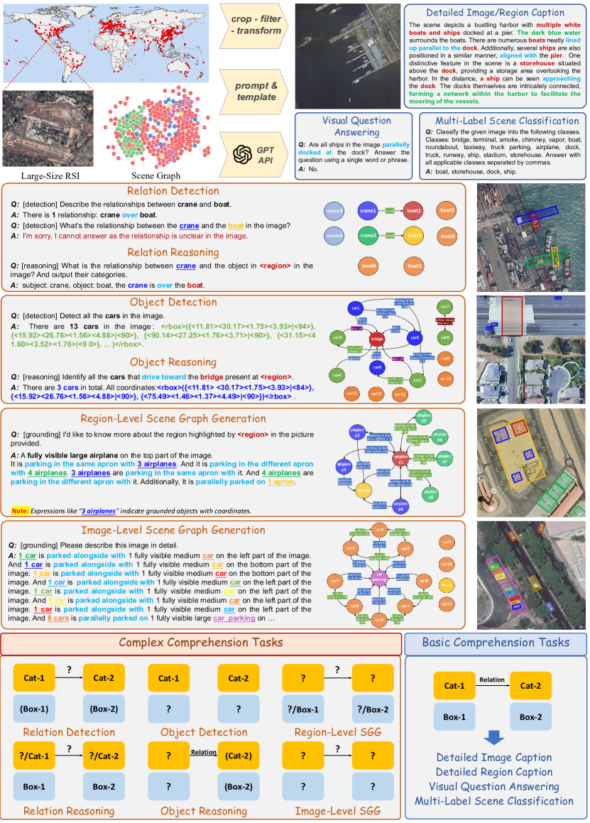
Intelligent interpretation of remote sensing images (RSIs) is crucial and meaningful. It provides valuable information for applications [29, 30]. Some studies collect remote sensing-specific image-text datasets [31, 32, 33, 34] from open-source geographic data, incorporating basic remote sensing knowledge into models. Furthermore, existing works [23, 25, 26, 27, 28, 24] propose instruction tuning datasets that encompass various downstream interpretation tasks, to obtain comprehensive Remote Sensing Large Multi-Modal Models (RSLMMs). To enhance the model’s interpretation accuracy, several region-level comprehension tasks [26, 27] are introduced, and some datasets design simple templates to get basic spatial relationships among targets [25]. However, when facing complex scenes with numerous targets, they are far from performing fine-grained comprehension. “Fine-grained” refers to accurately describing the fine-grained semantic relationships among targets like “driving in the same lane with”, rather than the simple rule-based relationships like “on the left of”.
Considering the above issues, we construct a large-scale fine-grained instruction tuning dataset, named FIT-RS (Remote Sensing Fine-Grained Instruction Tuning), which contains 1,800,851 high-quality instruction samples, aiming at enhancing the fine-grained comprehension ability of RSLMMs. As illustrated in Table 1, FIT-RS outperforms existing datasets in multiple aspects. Specifically, FIT-RS not only covers high-quality basic comprehension tasks, such as detailed image caption with an average length of 619.21, but also contains several novel complex comprehension tasks. Based on the tasks in FIT-RS, we further establish the FIT-RSFG (Remote Sensing Fine-Grained) benchmark.
Additionally, we establish the first benchmark to evaluate the remote sensing relation comprehension ability of LMMs, named FIT-RSRC (Remote Sensing Relation Comprehension). Following the mode of popular benchmarks in the general field, FIT-RSRC contains multiple-choice questions and adopts the CircularEval strategy [35, 19]. Moreover, FIT-RSRC features high-quality distractor options based on commonsense word lists created by experts and GPT-4, which increase the diversity and fairness of the benchmark. Our contributions can be concluded as follows:
-
•
A large-scale instruction tuning dataset, FIT-RS, is proposed, which contains over 1800k samples, covering basic interpretation tasks and novel complex comprehension tasks. It aims to enhance RSLMMs’ ability to understand complex scenes, particularly by improving their perception of object relations through tasks such as relation reasoning and scene graph generation.
-
•
We introduce SkySenseGPT, a comprehensive RSLMM that performs excellently on public remote sensing datasets and is capable of handling various complex comprehension tasks.
-
•
We propose the first benchmark for evaluating LMMs’ relation comprehension ability on remote sensing scenes, named FIT-RSRC. It includes high-quality distractor options derived from commonsense word lists, as well as unanswerable questions. Our proposed SkySenseGPT achieves an overall accuracy of 55.5% in FIT-RSRC, surpassing existing LMMs and RSLMMs.
2 Related Work
2.1 Complex Comprehension Tasks of General Large Multi-Modal Models
Existing LMMs acquire powerful comprehension abilities from large-scale, high-quality multimodal data from natural domains. In particular, the introduction of scene graph data [12, 36, 15] allows general LMMs to carry out fine-grained tasks. For example, Pink [37] introduces the referential comprehension task, enabling models to accomplish tasks like visual relation reasoning and visual spatial reasoning. All-Seeing project v2 [19] proposes a whole-image scene graph generation task and introduces CRPE benchmark to evaluate LMMs’ object recognition and relation comprehension abilities. These complex comprehension tasks involve modeling and evaluating explicitly annotated relationships between targets, enhancing fine-grained understanding of the images.
2.2 Large Multi-Modal Models in Remote Sensing
Existing RSLMMs [23, 25, 26, 27, 28, 24] have contributed to conversational understanding of RSIs, covering many basic visual-language downstream tasks. To strengthen RSLMMs’ precise interpretation ability, H2RSVLM [24] focuses on the inevitable “hallucination” problem and proposes the RSSA dataset to enhance the self-awareness capability of RSLMMs. Additionally, some works propose region-level comprehension tasks. For example, Geochat proposed grounded image captioning [25], SkyEyeGPT [27] introduces the phrase grounding task. However, existing works apply simple templates to create relationships, resulting in inaccurate relationships, and can not capture complex relationships related to the targets’ working or motion states. Such complex relationships are crucial for the fine-grained understanding of the scene.
3 The FIT-RS Dataset
Considering the rich semantic relationships among entities in complex remote sensing scenes, we aim to enhance the fine-grained comprehension capabilities of RSLMMs through instruction tuning, thus constructing the FIT-RS dataset. The overview of the FIT-RS is shown in Figure 1. In the following sections, we will introduce the data collection and processing, the task definitions and creation in FIT-RS, and the development of the FIT-RSRC benchmark.
3.1 Data Collection and Processing
First, we collect large-size very-high-resolution (VHR) RSIs worldwide and manually annotate them with detailed scene graph labels, forming the RSG dataset [38]. These images cover multiple complex semantic scenarios (e.g., airports, dams, and ports), with the sizes ranging from 512 768 to 27,860 31,096 pixels. Our FIT-RS dataset is an extension of RSG and contains more than 400,000 triplets and over 210,000 objects with rotated bounding boxes (RBoxes) in 1,273 RSIs. It includes 48 categories of important targets and 58 categories of high-value semantic relationships. Specifically, the semantic relationships are defined into 8 major categories: “distance warning”, “spatial topology”, “functional description”, “circuit layout”, “movement status”, “emission status”, “construction status” and “parking status”, which contain 58 subcategories. These deeply characterize the target in context. Within the scenes, diverse objectives share rich inter-class and intra-class relationships, furnishing foundational support for fine-grained scene comprehension. Due to the limited resolution of existing image-text visual encoders [39], we employ the common-used cropping strategy [40] to process large-size images. Using a sliding window of 512 512 pixels with a 100-pixel overlap, original large-size RSIs are cropped into patches. Then we filter targets and relationships using a completeness threshold, obtaining 82,532 valid image patches.
As shown in the below part of Figure 1, in the scene graph, when considering object location, the triplets can be expressed as: <subject-box, relation, object-box>. These elements form the foundation for understanding the interactive relationships among objects. However, it is difficult for RSLMMs to directly understand the entire scene graph. To better explore the model’s fine-grained understanding capabilities, we tailor a series of instruction following tasks grounded on the above fundamental elements. For basic comprehension tasks, we construct the instruction from all scene graph information. For complex comprehension tasks, we adjust the known elements in the input questions and ask the model to provide the unknown elements. This approach allows the creation of a set of progressively complex tasks, thereby fostering LMMs’ fine-grained understanding of intricate remote sensing scenarios. Table 2 shows the details of samples within the FIT-RS dataset.
| Task Type | Task | Sample Number |
| IC | Detailed Image Caption | 82532 |
| RC | Detailed Region Caption | 90744 |
| VQA | Visual Question Answering | 498565 |
| SC | Multi-Label Scene Classification | 165074 |
| CC | Relation Detection | 181799 |
| Relation Reasoning | 124496 | |
| Object Detection | 140626 | |
| Object Reasoning | 295395 | |
| Region-Level Scene Graph Generation | 93199 | |
| Image-Level Scene Graph Generation | 62945 | |
| MT | Multi-Turn/Task Conversation | 65476 |
3.2 Data Construction for Basic Comprehension Tasks
Similar to common remote sensing visual-language tasks, we construct several basic comprehension tasks. However, our distinction lies in improving the quality and richness of the instructions by making full use of fine-grained relationships.
-
•
Detailed Image & Region Caption. Benefiting from the scene graph’s high-quality detailed annotation relations among objects, we are capable of obtaining in-depth portrayals of images. The Region Caption task follows the subsequent region-level SGG but removes the bounding boxes. For the detailed Image Caption task, the generation pipeline is as follows.
(i) First, we extract valid triplets from the patches after cropping as the foreground information. (ii) Then we use the efficient TinyLLaVA-3.1B [41] to swiftly generate concise background descriptions for numerous RSIs. (iii) Finally, we combine them as the prompt to obtain detailed and fluent sentences using GPT-4/GPT-3.5 [1]. In this way, we obtain 82,532 image-caption pairs in total, with 19,874 by GPT-4 and 62,658 by GPT-3.5, the average character length of the caption generated by GPT-4 is 892.66 and the overall average length is 619.21, significantly surpassing existing remote sensing image-text datasets (e.g., RS5M [31]: 87, SkyScripts [32]: 56, HqDC-1.4M [24]: 369).
-
•
Visual Question Answering. Benefiting from the rich relationships among objects, we can perform more fine-grained Visual Question Answering. Compared to conventional VQA tasks, we have also introduced relation-based question answering.
Specifically, we design 4 types of questions as follows. (i) Presence Questions. These inquiries address the existence of a specific category. We balance positive and negative responses to avoid an overabundance of negative answers. (ii) Comparison Questions. We follow the existing datasets [42] to compare the quantities of two categories. (iii) Count Questions. We design single-category counting questions and introduce relational constraints, asking for the number of a specific triplet in the image. (iv) Relation Questions. We design questions targeting the diversity of relationships. We select one subject-object category pair to inquire about the existence of a specific relation or choose a triplet to question whether the uniqueness of that relationship is satisfied. In summary, the VQA tasks in FIT-RS are more detailed compared to existing datasets and more thoroughly test RSLMMs’ fine-grained image understanding ability.
-
•
Multi-Label Scene Classification. We first manually classify original RSIs into 10 main scene categories. Subsequently, we design quantity-based filtering rules to select the primary target categories from the image patches, which serve as secondary class labels in a multi-label context. The final scene classification task contains two types of instructions: single-label scene classification and multi-label target classification.
3.3 Data Construction for Complex Comprehension Tasks
Fined-grained scene comprehension ability is important for RSLMMs while existing datasets only provide limited comprehension tasks, e.g., visual grounding and region caption. We further explore more challenging tasks besides the above basic tasks. Specifically, to make full use of the triplets <subject, relation, object> in the scene graph, we set up a series of complex comprehension tasks, focusing sequentially on relation understanding, subject/object comprehension, and overall triplet interpretation, as illustrated in the lower part of Figure 1. Next, we provide a detailed introduction to these complex comprehension tasks.
-
•
Relation Detection & Reasoning. Benefiting from the precisely annotated rich semantic relations in the scene graph, we designed two tasks to enhance the RSLMM’s perception of visual relations among targets. From the categories and locations of subjects and objects, we randomly select partial information as incomplete input. The Relation Detection task requires the model to output only the relations among the entities. The Relation Reasoning task additionally requires the model to output the categories of the subject and object. The relation is marked by <rel></rel>.
-
•
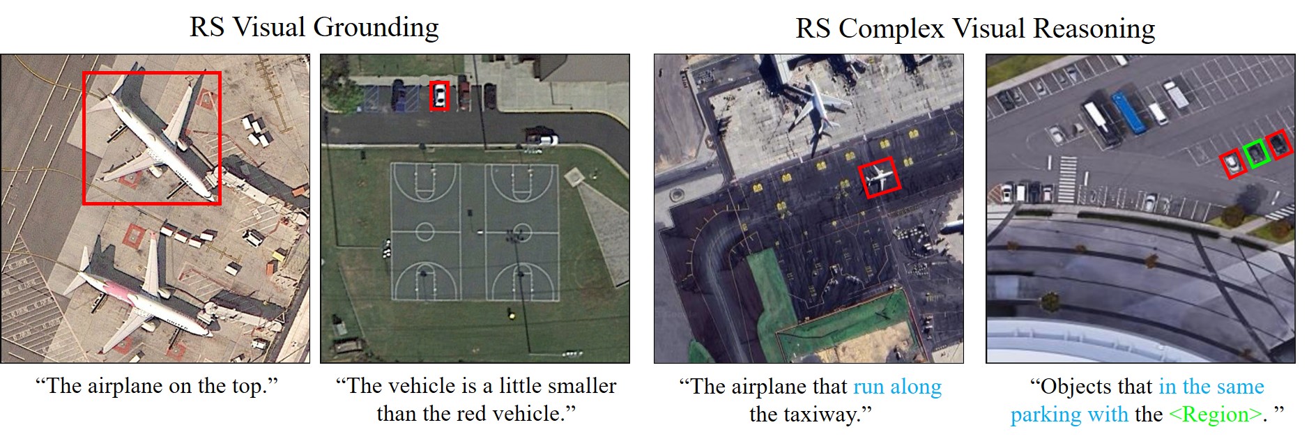
Object Detection & Reasoning. These two tasks involve region-based understanding and outputs. Considering the precision of RBoxes [43, 44, 45], we employ the “oc” definition to represent precise RBoxes, and use special tag <rbox> to the location of entities in the format: <rbox>(<cx><cy><w><h>|<angle>)</rbox>. Here, the coordinates are normalized to [0.00, 100.00] with two decimal places, and the angle is represented as an integer in degrees. (i) Object Detection aims for the model to detect and output all coordinates of a specific category. (ii) Object Reasoning is more challenging: give a specific relation and random categories and locations as the query, the model is required to output the categories and locations of all targets that meet the conditions. This task supports region input and relation queries, like “Provide the coordinates of all airplanes that are <rel>parallelly parked on</rel> the apron present at <region> in the image.”, assisting users in achieving more precise object interpretation. As illustrated in Figure 2, our object reasoning task offers certain advantages compared to traditional remote sensing visual grounding task [46].
-
•
Region-Level & Image-Level Scene Graph Generation. These two tasks are relatively the most challenging, aiming to explore the upper boundary of RSLMMs’ fine-grained understanding capabilities. (i) Region-Level SGG requires the model to describe the target’s relative size, position, and visibility based on the input area, then generate all related triplets, using “it” to refer to the target; (ii) Image-Level SGG involves directly generating scene graphs for the whole image, with isolated targets that have no relationships being appended to the answer in the format of object detection. Grounded targets are represented as <ref>target></ref><rbox>box</rbox>.
For all the aforementioned tasks, we construct corresponding negative samples, which are instructions to refuse to answer when it comes to background images, to enhance the stability of the model. Templates for all complex comprehension tasks and negative sample responses can be found in the Appendix. Additionally, we randomly mix different tasks to create multi-turn conversation data.
3.4 Evaluation of Remote Sensing Relation Comprehension
Given the current lack of a publicly available benchmark for comprehensive and quantitative evaluation of existing LMMs in remote sensing relation understanding, we propose the FIT-RSRC (Remote Sensing Relation Comprehension) benchmark. It is designed in the form of single-choice questions, containing four different types of questions and high-quality distractor options as in Figure 3. Following the mainstream general benchmark, FIT-RSRC employs CircularEval [35] as the evaluation strategy to enhance fairness.
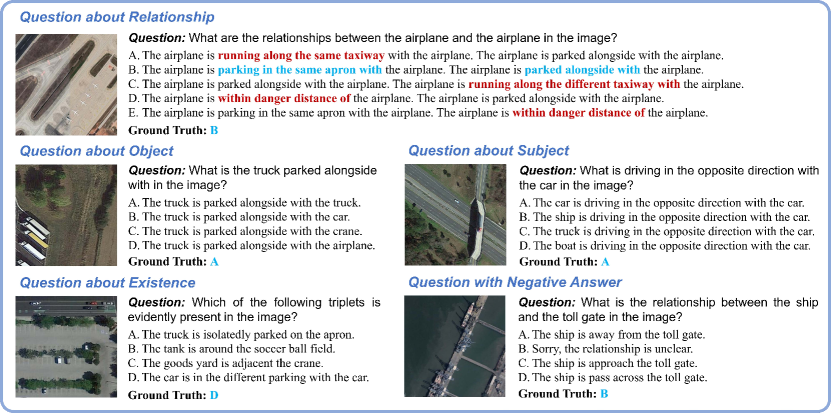
To ensure the high quality of distractors, all incorrect options are generated within the scope of a preset commonsense word list, which is created by GPT-4 in conjunction with expert manual screening. This ensures that incorrect options that can be judged solely by commonsense expressions, such as “taxiway is running along the storehouse”, do not occur. As shown in the first example in Figure 3, each sample in our benchmark consists of one correct option and three distractors. If the correct answer contains multiple relationships, the length of the incorrect answer will be kept equal to it. At the same time, the wrong options may incorporate correct content to improve the quality of the distractors. Moreover, to assess both the veracity of the models and their robustness against negative images, we have incorporated unanswerable answers, thus incorporating the LMMs’ capability to hallucinate negative instances into our quantitative evaluation.
4 The SkySenseGPT Model
The architecture SkySenseGPT follows mainstream LMMs, composed of a visual encoder, i.e. CLIP-ViT-L14 [39] with a resolution of 336 336, a multilayer perceptron (MLP) as the multi-modal projector, and an LLM (Vicuna-v1.5 [47]). Input images are resized to 504 504 pixels following the Geochat [25]. And we follow LLaVA-v1.5 [7] to get the pre-trained MLP projector. For the instruction tuning stage, we freeze the vision encoder, finetune the projector, and adopt LoRA [48] to finetune the LLM.
We split the FIT-RS dataset into train, val, and test sets with a ratio of 6:2:2. We use the train-val set for instruction tuning, and considering the efficiency of LMM inference, we randomly sample a portion from the test set for evaluation. In this way, we obtained 1415k instruction samples for training. Furthermore, we additionally collect existing public datasets and transform them into the final instruction tuning data for training. Specifically, we collected 3 scene classification datasets (NWPU [49], UCM [50], and RSITMD [51]), 3 VQA datasets (EarthVQA [52], Floodnet-VQA[53], and RSVQA-LR [42]), and 3 object detection datasets (DOTA-v2.0 [40], DIOR [54], and FAIR1M [55]) to enrich the instruction dataset. This part of the additional data contains 365k samples. Detailed information can be found in the Appendix.
5 Experiments
In this section, we present the experimental results of the FIT-RSFG benchmark based on the FIT-RS dataset and the FIT-RSRC benchmark. Moreover, we conduct generalization experiments with SkySenseGPT using existing public datasets. All experiments are conducted in 4 NVIDIA A100 GPUs (40G). The specific details for all test sets can be found in the Appendix.
5.1 Benchmarks
We employ existing mainstream models to evaluate all the tasks in the FIT-RS dataset, creating the FIT-RSFG benchmark. To construct the FIT-RSRC benchmark, we extensively evaluate various LMMs and RSLMMs, demonstrating FIT-RSRC’s reliability and ease of generalization.
| Task Type | Task | Metric | LLaVA1.5-7B (ZS) | GeoChat (ZS) | SkySenseGPT (FT) |
|---|---|---|---|---|---|
| IC | Detailed Image Caption | BLEU-1 | 15.38 | 8.79 | 27.31 |
| RC | Detailed Region Caption | BLEU-1 | 14.70 | 14.55 | 75.82 |
| VQA | VQA | Ave Acc | 58.59 | 53.47 | 79.76 |
| SC | Multi-Label Scene Classification | Scene Acc | 56.18 | 42.27 | 82.23 |
| Obj F1-Score | 12.84 | 14.95 | 71.43 | ||
| CC | Relation Detection | F1-Score | Failed | Failed | 88.68 |
| Relation Reasoning | F1-Score | Failed | Failed | 74.33 | |
| Object Detection | mAP | Failed | 6.13 | 27.40 | |
| Object Reasoning | mAP | Failed | Failed | 5.71 | |
| Region-Level SGG | Recall | Failed | Failed | 17.01 | |
| Image-Level SGG | Recall | Failed | Failed | 9.60 | |
| MT | Multi-Turn/Task Conv | GPT-eval | 2.74 | 3.64 | 6.60 |
5.1.1 FIT-RSFG Benchmark
To construct the FIT-RSFG benchmark, we employ LLaVA-v1.5 [7] and Geochat [25] as our baseline models and evaluate SkySenseGPT for fine-tuning results. We adopt the common metric mAP [30] with an IoU threshold of 0.25 for tasks related to target localization. For SGG tasks, we adopt the recall [56, 57] and mean recall metrics [58, 59]. We employ GPT-3.5 to get GPT-eval scores, which range from 0 to 10. The results are shown in Table 3. After fine-tuning, the model can handle complex tasks, showing a clear improvement compared to the baseline methods. The detailed results can be found in the Appendix.
5.1.2 FIT-RSRC Benchmark
Due to the conciseness of the single-choice format, we evaluate several general-domain LMMs, including LLaVA-1.5-7B [7], LLaVA-HR-7B [60], and TinyLLaVA [41] that we used in constructing image descriptions. We also evaluate currently open-sourced RSLMM like GeoChat [25] on the FIT-RSRC.
| Method | Setting | Subject | Object | Relation | Existence | Ave. Acc |
| LLaVA-1.5-7B [7] | ZS | 6.4 | 11.2 | 21.0 | 7.8 | 11.6 |
| TinyLLaVA [41] | 22.0 | 18.0 | 12.0 | 55.6 | 26.9 | |
| LLaVA-HR-7B [60] | 7.8 | 13.4 | 32.6 | 47.8 | 25.4 | |
| GeoChat [25] | 7.6 | 8.6 | 25.6 | 45.6 | 21.9 | |
| SkySenseGPT | TL | 25.2 | 54.0 | 50.4 | 92.2 | 55.5 |
The results are shown in Table 4. Based on the results, existing LMMs generally showcase a good ability to identify the presence or absence of triplets, indicating their basic capability to recognize objects in remote sensing scenes. However, when it comes to fine-grained understanding related to object relationships, the performance of existing models is generally poor. It is worth noting that LLaVA-HR achieves high accuracy in the zero-shot setting, indicating that high-resolution input is significant for the fine-grained understanding of RSIs. Despite being set up for cross-task transfer learning, SkySenseGPT demonstrates a better ability to recognize relationships than the other models.
5.2 Generalization Experiments
| Task | Setting | Dataset | Metric | Geo- Chat [25] | LHRS- Bot [28] | H2RS VLM [24] | SkySense GPT |
|---|---|---|---|---|---|---|---|
| Scene Classification | ZS | SIRI-WHU | Acc | 66.63 | 62.66 | 68.50 | 74.75 |
| AID | Acc | 72.03 | 91.26 | 89.33 | 92.25 | ||
| WHU-RS19 | Acc | 86.47 | 93.17 | 97.00 | 97.02 | ||
| AID-multi | F1-Score | 46.55 | - | - | 47.97 | ||
| VQA | ZS | RSVQA-HR | Pre. Acc | 58.45 | - | 65.00 | 69.14 |
| Comp. Acc | 83.19 | - | 83.70 | 84.14 | |||
| Avg. Acc | 70.82 | - | 74.35 | 76.64 | |||
| FT | RSVQA-LR | Rural. Acc | 91.09 | 89.07 | 88.00 | 95.00 | |
| Pre. Acc | 90.33 | 88.51 | 89.58 | 91.07 | |||
| Comp. Acc | 94.00 | 90.00 | 89.79 | 92.00 | |||
| Avg. Acc | 91.81 | 89.19 | 89.12 | 92.69 |
We compare our SkySenseGPT with state-of-the-art RSLMMs in public datasets as in Table 5. For scene classification, we choose four representative datasets SIRI-WHU [61], AID [62], WHU-RS19 [63] and AID-Multilabel [64] for zero-shot generalization experiments. For VQA, we choose two representative datasets: RSVQA-HR and RSVQA-LR [42]. In the scene classification task, SkySenseGPT surpasses the current RSLMMs, especially exceeding state-of-the-art H2RSVLM [24] by 6.25 % on the SIRI-WHU dataset. And in the VQA task, our model achieves high accuracy under both low and high resolutions, indicating that it can serve complex fine-grained tasks and possess strong basic comprehension capabilities for foundational tasks.
6 Conclusion
In this paper, we construct FIT-RS, a large-scale instruction tuning dataset aimed at enhancing the fine-grained comprehension capability of RSLMMs. It covers various tasks and features high-quality corpora, including basic and novel complex tasks. Based on the FIT-RS, we construct the FIT-RSFG benchmark. Furthermore, we construct the first benchmark, FIT-RSRC, for evaluating LMMs’ ability in remote sensing relationship comprehension. By combining FIT-RS with other multi-modal corpora, we further introduce SkySenseGPT, which excels in different granular tasks and surpasses current RSLMMs in public datasets. As there is still room for improvement in challenging complex tasks, we hope that FIT-RS can contribute to building more powerful RSLMMs.
References
- [1] Josh Achiam, Steven Adler, Sandhini Agarwal, Lama Ahmad, Ilge Akkaya, Florencia Leoni Aleman, Diogo Almeida, Janko Altenschmidt, Sam Altman, Shyamal Anadkat, et al. Gpt-4 technical report. arXiv preprint arXiv:2303.08774, 2023.
- [2] Hugo Touvron, Louis Martin, Kevin Stone, Peter Albert, Amjad Almahairi, Yasmine Babaei, Nikolay Bashlykov, Soumya Batra, Prajjwal Bhargava, Shruti Bhosale, et al. Llama 2: Open foundation and fine-tuned chat models. arXiv preprint arXiv:2307.09288, 2023.
- [3] Haotian Liu, Chunyuan Li, Qingyang Wu, and Yong Jae Lee. Visual instruction tuning. Advances in Neural Information Processing Systems, 36, 2024.
- [4] Weiyun Wang, Min Shi, Qingyun Li, Wenhai Wang, Zhenhang Huang, Linjie Xing, Zhe Chen, Hao Li, Xizhou Zhu, Zhiguo Cao, et al. The all-seeing project: Towards panoptic visual recognition and understanding of the open world. In International Conference on Learning Representations, 2023.
- [5] Deyao Zhu, Jun Chen, Xiaoqian Shen, Xiang Li, and Mohamed Elhoseiny. Minigpt-4: Enhancing vision-language understanding with advanced large language models. In International Conference on Learning Representations, 2023.
- [6] Wenhai Wang, Zhe Chen, Xiaokang Chen, Jiannan Wu, Xizhou Zhu, Gang Zeng, Ping Luo, Tong Lu, Jie Zhou, Yu Qiao, et al. Visionllm: Large language model is also an open-ended decoder for vision-centric tasks. Advances in Neural Information Processing Systems, 36, 2024.
- [7] Haotian Liu, Chunyuan Li, Yuheng Li, and Yong Jae Lee. Improved baselines with visual instruction tuning. arXiv preprint arXiv:2310.03744, 2023.
- [8] Jinze Bai, Shuai Bai, Shusheng Yang, Shijie Wang, Sinan Tan, Peng Wang, Junyang Lin, Chang Zhou, and Jingren Zhou. Qwen-vl: A frontier large vision-language model with versatile abilities. arXiv preprint arXiv:2308.12966, 2023.
- [9] Zhe Chen, Jiannan Wu, Wenhai Wang, Weijie Su, Guo Chen, Sen Xing, Zhong Muyan, Qinglong Zhang, Xizhou Zhu, Lewei Lu, et al. Internvl: Scaling up vision foundation models and aligning for generic visual-linguistic tasks. arXiv preprint arXiv:2312.14238, 2023.
- [10] Machel Reid, Nikolay Savinov, Denis Teplyashin, Dmitry Lepikhin, Timothy Lillicrap, Jean-baptiste Alayrac, Radu Soricut, Angeliki Lazaridou, Orhan Firat, Julian Schrittwieser, et al. Gemini 1.5: Unlocking multimodal understanding across millions of tokens of context. arXiv preprint arXiv:2403.05530, 2024.
- [11] Sahar Kazemzadeh, Vicente Ordonez, Mark Matten, and Tamara Berg. Referitgame: Referring to objects in photographs of natural scenes. In Proceedings of the 2014 conference on empirical methods in natural language processing (EMNLP), pages 787–798, 2014.
- [12] Ranjay Krishna, Yuke Zhu, Oliver Groth, Justin Johnson, Kenji Hata, Joshua Kravitz, Stephanie Chen, Yannis Kalantidis, Li-Jia Li, David A Shamma, et al. Visual genome: Connecting language and vision using crowdsourced dense image annotations. International journal of computer vision, 123:32–73, 2017.
- [13] Drew A Hudson and Christopher D Manning. Gqa: A new dataset for real-world visual reasoning and compositional question answering. In Proceedings of the IEEE/CVF conference on Computer Vision and Pattern Recognition, pages 6700–6709, 2019.
- [14] Arjun Mani, Nobline Yoo, Will Hinthorn, and Olga Russakovsky. Point and ask: Incorporating pointing into visual question answering. arXiv preprint arXiv:2011.13681, 2020.
- [15] Jingkang Yang, Yi Zhe Ang, Zujin Guo, Kaiyang Zhou, Wayne Zhang, and Ziwei Liu. Panoptic scene graph generation. In European Conference on Computer Vision, 2022.
- [16] Fangyu Liu, Guy Emerson, and Nigel Collier. Visual spatial reasoning. Transactions of the Association for Computational Linguistics, 11:635–651, 2023.
- [17] Jiabo Ye, Anwen Hu, Haiyang Xu, Qinghao Ye, Ming Yan, Guohai Xu, Chenliang Li, Junfeng Tian, Qi Qian, Ji Zhang, et al. Ureader: Universal ocr-free visually-situated language understanding with multimodal large language model. In The 2023 Conference on Empirical Methods in Natural Language Processing, 2023.
- [18] Yuliang Liu, Biao Yang, Qiang Liu, Zhang Li, Zhiyin Ma, Shuo Zhang, and Xiang Bai. Textmonkey: An ocr-free large multimodal model for understanding document. arXiv preprint arXiv:2403.04473, 2024.
- [19] Weiyun Wang, Yiming Ren, Haowen Luo, Tiantong Li, Chenxiang Yan, Zhe Chen, Wenhai Wang, Qingyun Li, Lewei Lu, Xizhou Zhu, et al. The all-seeing project v2: Towards general relation comprehension of the open world. arXiv preprint arXiv:2402.19474, 2024.
- [20] Hanguang Xiao, Feizhong Zhou, Xingyue Liu, Tianqi Liu, Zhipeng Li, Xin Liu, and Xiaoxuan Huang. A comprehensive survey of large language models and multimodal large language models in medicine. arXiv preprint arXiv:2405.08603, 2024.
- [21] Wenhai Wang, Jiangwei Xie, ChuanYang Hu, Haoming Zou, Jianan Fan, Wenwen Tong, Yang Wen, Silei Wu, Hanming Deng, Zhiqi Li, et al. Drivemlm: Aligning multi-modal large language models with behavioral planning states for autonomous driving. arXiv preprint arXiv:2312.09245, 2023.
- [22] Can Cui, Yunsheng Ma, Xu Cao, Wenqian Ye, Yang Zhou, Kaizhao Liang, Jintai Chen, Juanwu Lu, Zichong Yang, Kuei-Da Liao, et al. A survey on multimodal large language models for autonomous driving. In Proceedings of the IEEE/CVF Winter Conference on Applications of Computer Vision, pages 958–979, 2024.
- [23] Yuan Hu, Jianlong Yuan, Congcong Wen, Xiaonan Lu, and Xiang Li. Rsgpt: A remote sensing vision language model and benchmark. arXiv preprint arXiv:2307.15266, 2023.
- [24] Chao Pang, Jiang Wu, Jiayu Li, Yi Liu, Jiaxing Sun, Weijia Li, Xingxing Weng, Shuai Wang, Litong Feng, Gui-Song Xia, et al. H2rsvlm: Towards helpful and honest remote sensing large vision language model. arXiv preprint arXiv:2403.20213, 2024.
- [25] Kartik Kuckreja, Muhammad Sohail Danish, Muzammal Naseer, Abhijit Das, Salman Khan, and Fahad Shahbaz Khan. Geochat: Grounded large vision-language model for remote sensing. Proceedings of the IEEE Conference on Computer Vision and Pattern Recognition, 2024.
- [26] Wei Zhang, Miaoxin Cai, Tong Zhang, Yin Zhuang, and Xuerui Mao. Earthgpt: A universal multi-modal large language model for multi-sensor image comprehension in remote sensing domain. arXiv preprint arXiv:2401.16822, 2024.
- [27] Yang Zhan, Zhitong Xiong, and Yuan Yuan. Skyeyegpt: Unifying remote sensing vision-language tasks via instruction tuning with large language model. arXiv preprint arXiv:2401.09712, 2024.
- [28] Dilxat Muhtar, Zhenshi Li, Feng Gu, Xueliang Zhang, and Pengfeng Xiao. Lhrs-bot: Empowering remote sensing with vgi-enhanced large multimodal language model. arXiv preprint arXiv:2402.02544, 2024.
- [29] Pravada S Bharatkar and Rahila Patel. Evaluation of rsi classification methods for effective land use mapping. In 2013 International Conference on Communication Systems and Network Technologies, pages 109–113. IEEE, 2013.
- [30] Mark Everingham, SM Ali Eslami, Luc Van Gool, Christopher KI Williams, John Winn, and Andrew Zisserman. The pascal visual object classes challenge: A retrospective. International Journal of Computer Vision, 111:98–136, 2015.
- [31] Zilun Zhang, Tiancheng Zhao, Yulong Guo, and Jianwei Yin. Rs5m: A large scale vision-language dataset for remote sensing vision-language foundation model. arXiv preprint arXiv:2306.11300, 2023.
- [32] Zhecheng Wang, Rajanie Prabha, Tianyuan Huang, Jiajun Wu, and Ram Rajagopal. Skyscript: A large and semantically diverse vision-language dataset for remote sensing. In Proceedings of the AAAI Conference on Artificial Intelligence, volume 38, pages 5805–5813, 2024.
- [33] Utkarsh Mall, Cheng Perng Phoo, Meilin Kelsey Liu, Carl Vondrick, Bharath Hariharan, and Kavita Bala. Remote sensing vision-language foundation models without annotations via ground remote alignment. arXiv preprint arXiv:2312.06960, 2023.
- [34] Zhenghang Yuan, Zhitong Xiong, Lichao Mou, and Xiao Xiang Zhu. Chatearthnet: A global-scale, high-quality image-text dataset for remote sensing. arXiv preprint arXiv:2402.11325, 2024.
- [35] Yuan Liu, Haodong Duan, Yuanhan Zhang, Bo Li, Songyang Zhang, Wangbo Zhao, Yike Yuan, Jiaqi Wang, Conghui He, Ziwei Liu, et al. Mmbench: Is your multi-modal model an all-around player? arXiv preprint arXiv:2307.06281, 2023.
- [36] Danfei Xu, Yuke Zhu, Christopher B Choy, and Li Fei-Fei. Scene graph generation by iterative message passing. In Computer Vision and Pattern Recognition, pages 5410–5419, 2017.
- [37] Shiyu Xuan, Qingpei Guo, Ming Yang, and Shiliang Zhang. Pink: Unveiling the power of referential comprehension for multi-modal llms. arXiv preprint arXiv:2310.00582, 2023.
- [38] Yansheng Li, Linlin Wang, Tingzhu Wang, Xue Yang, Junwei Luo, Qi Wang, Youming Deng, Wenbin Wang, Xian Sun, Haifeng Li, Bo Dang, Yongjun Zhang, Yi Yu, and Yan Junchi. Scene graph generation in large-size vhr satellite imagery: A large-scale dataset and a context-aware approach. arXiv preprint arXiv:2406.09410, 2024.
- [39] Alec Radford, Jong Wook Kim, Chris Hallacy, Aditya Ramesh, Gabriel Goh, Sandhini Agarwal, Girish Sastry, Amanda Askell, Pamela Mishkin, Jack Clark, et al. Learning transferable visual models from natural language supervision. In International Conference on Machine Learning, pages 8748–8763. PMLR, 2021.
- [40] Jian Ding, Nan Xue, Gui-Song Xia, Xiang Bai, Wen Yang, Michael Ying Yang, Serge Belongie, Jiebo Luo, Mihai Datcu, Marcello Pelillo, et al. Object detection in aerial images: A large-scale benchmark and challenges. IEEE transactions on pattern analysis and machine intelligence, 44(11):7778–7796, 2021.
- [41] Baichuan Zhou, Ying Hu, Xi Weng, Junlong Jia, Jie Luo, Xien Liu, Ji Wu, and Lei Huang. Tinyllava: A framework of small-scale large multimodal models. arXiv preprint arXiv:2402.14289, 2024.
- [42] Sylvain Lobry, Diego Marcos, Jesse Murray, and Devis Tuia. Rsvqa: Visual question answering for remote sensing data. IEEE Transactions on Geoscience and Remote Sensing, 58(12):8555–8566, 2020.
- [43] Xue Yang, Xiaojiang Yang, Jirui Yang, Qi Ming, Wentao Wang, Qi Tian, and Junchi Yan. Learning high-precision bounding box for rotated object detection via kullback-leibler divergence. Advances in Neural Information Processing Systems, 34:18381–18394, 2021.
- [44] Yue Zhou, Xue Yang, Gefan Zhang, Jiabao Wang, Yanyi Liu, Liping Hou, Xue Jiang, Xingzhao Liu, Junchi Yan, Chengqi Lyu, et al. Mmrotate: A rotated object detection benchmark using pytorch. In ACM International Conference on Multimedia, pages 7331–7334, 2022.
- [45] Xue Yang, Gefan Zhang, Xiaojiang Yang, Yue Zhou, Wentao Wang, Jin Tang, Tao He, and Junchi Yan. Detecting rotated objects as gaussian distributions and its 3-d generalization. IEEE Transactions on Pattern Analysis and Machine Intelligence, 45(4):4335–4354, 2023.
- [46] Yang Zhan, Zhitong Xiong, and Yuan Yuan. Rsvg: Exploring data and models for visual grounding on remote sensing data. IEEE Transactions on Geoscience and Remote Sensing, 61:1–13, 2023.
- [47] Wei-Lin Chiang, Zhuohan Li, Zi Lin, Ying Sheng, Zhanghao Wu, Hao Zhang, Lianmin Zheng, Siyuan Zhuang, Yonghao Zhuang, Joseph E. Gonzalez, Ion Stoica, and Eric P. Xing. Vicuna: An open-source chatbot impressing gpt-4 with 90%* chatgpt quality, March 2023.
- [48] Edward J Hu, Yelong Shen, Phillip Wallis, Zeyuan Allen-Zhu, Yuanzhi Li, Shean Wang, Lu Wang, and Weizhu Chen. Lora: Low-rank adaptation of large language models. arXiv preprint arXiv:2106.09685, 2021.
- [49] Gong Cheng, Junwei Han, and Xiaoqiang Lu. Remote sensing image scene classification: Benchmark and state of the art. Proceedings of the IEEE, 105(10):1865–1883, 2017.
- [50] Bo Qu, Xuelong Li, Dacheng Tao, and Xiaoqiang Lu. Deep semantic understanding of high resolution remote sensing image. In 2016 International conference on computer, information and telecommunication systems (Cits), pages 1–5. IEEE, 2016.
- [51] Zhiqiang Yuan, Wenkai Zhang, Kun Fu, Xuan Li, Chubo Deng, Hongqi Wang, and Xian Sun. Exploring a fine-grained multiscale method for cross-modal remote sensing image retrieval. arXiv preprint arXiv:2204.09868, 2022.
- [52] Junjue Wang, Zhuo Zheng, Zihang Chen, Ailong Ma, and Yanfei Zhong. Earthvqa: Towards queryable earth via relational reasoning-based remote sensing visual question answering. In Proceedings of the AAAI Conference on Artificial Intelligence, volume 38, pages 5481–5489, 2024.
- [53] Maryam Rahnemoonfar, Tashnim Chowdhury, Argho Sarkar, Debvrat Varshney, Masoud Yari, and Robin Roberson Murphy. Floodnet: A high resolution aerial imagery dataset for post flood scene understanding. IEEE Access, 9:89644–89654, 2021.
- [54] Gong Cheng, Jiabao Wang, Ke Li, Xingxing Xie, Chunbo Lang, Yanqing Yao, and Junwei Han. Anchor-free oriented proposal generator for object detection. IEEE Transactions on Geoscience and Remote Sensing, 60:1–11, 2022.
- [55] Xian Sun, Peijin Wang, Zhiyuan Yan, Feng Xu, Ruiping Wang, Wenhui Diao, Jin Chen, Jihao Li, Yingchao Feng, Tao Xu, et al. Fair1m: A benchmark dataset for fine-grained object recognition in high-resolution remote sensing imagery. ISPRS Journal of Photogrammetry and Remote Sensing, 184:116–130, 2022.
- [56] Rowan Zellers, Mark Yatskar, Sam Thomson, and Yejin Choi. Neural motifs: Scene graph parsing with global context. In Proceedings of the IEEE conference on Computer Vision and Pattern Recognition, pages 5831–5840, 2018.
- [57] Kaihua Tang, Hanwang Zhang, Baoyuan Wu, Wenhan Luo, and Wei Liu. Learning to compose dynamic tree structures for visual contexts. In Proceedings of the IEEE/CVF conference on Computer Vision and Pattern Recognition, pages 6619–6628, 2019.
- [58] Kaihua Tang, Yulei Niu, Jianqiang Huang, Jiaxin Shi, and Hanwang Zhang. Unbiased scene graph generation from biased training. In Proceedings of the IEEE/CVF conference on Computer Vision and Pattern Recognition, pages 3716–3725, 2020.
- [59] Xingning Dong, Tian Gan, Xuemeng Song, Jianlong Wu, Yuan Cheng, and Liqiang Nie. Stacked hybrid-attention and group collaborative learning for unbiased scene graph generation. In Proceedings of the IEEE/CVF Conference on Computer Vision and Pattern Recognition, pages 19427–19436, 2022.
- [60] Gen Luo, Yiyi Zhou, Yuxin Zhang, Xiawu Zheng, Xiaoshuai Sun, and Rongrong Ji. Feast your eyes: Mixture-of-resolution adaptation for multimodal large language models. arXiv preprint arXiv:2403.03003, 2024.
- [61] Qiqi Zhu, Yanfei Zhong, Bei Zhao, Gui-Song Xia, and Liangpei Zhang. Bag-of-visual-words scene classifier with local and global features for high spatial resolution remote sensing imagery. IEEE Geoscience and Remote Sensing Letters, 13(6):747–751, 2016.
- [62] Gui-Song Xia, Jingwen Hu, Fan Hu, Baoguang Shi, Xiang Bai, Yanfei Zhong, Liangpei Zhang, and Xiaoqiang Lu. Aid: A benchmark data set for performance evaluation of aerial scene classification. IEEE Transactions on Geoscience and Remote Sensing, 55(7):3965–3981, 2017.
- [63] Dengxin Dai and Wen Yang. Satellite image classification via two-layer sparse coding with biased image representation. IEEE Geoscience and remote sensing letters, 8(1):173–176, 2010.
- [64] Yuansheng Hua, Lichao Mou, and Xiao Xiang Zhu. Relation network for multi-label aerial image classification. IEEE Transactions on Geoscience and Remote Sensing, DOI:10.1109/TGRS.2019.2963364.
- [65] Gong Cheng, Xiang Yuan, Xiwen Yao, Kebing Yan, Qinghua Zeng, Xingxing Xie, and Junwei Han. Towards large-scale small object detection: Survey and benchmarks. IEEE Transactions on Pattern Analysis and Machine Intelligence, 2023.
Appendix
Appendix A Overview
The FIT-RS dataset, data generation scripts, and model weight of SkySenseGPT will be open-sourced at https://github.com/Luo-Z13/SkySenseGPT, the DOI of the data repository is 10.57967/hf/2529. In this Appendix, we provide a detailed description of the templates and prompts used to create various instruction tuning tasks in the FIT-RS dataset. We also provide specific details about our constructed datasets and the public datasets used for training and testing. Additionally, we present detailed experimental results and comprehensive visualization results.
Appendix B The FIT-RS Dataset
We provide a detailed explanation of the specific question templates and prompts used for different tasks in the FIT-RS dataset, and their specific formats are shown in Table A1. During data preprocessing, as we employ the conventional cropping strategy to cut the original large-size remote sensing images (RSIs) into small patches, we set the completeness threshold, i.e., the intersection over foreground (iof) threshold, as 0.3 for detailed image caption task to provide comprehensive descriptions, and 0.55 for other tasks to ensure the reliability of target-related corpus.
| Task Type | Task | Specific Format |
| IC | Detailed Image Caption | - |
| RC | Detailed Region Caption | - |
| VQA | Visual Question Answering | Answer in one word or a short phrase. |
| SC | Multi-Label Scene Classification | Classify the given image in one of the following classes. / Answer in one word or a short phrase. Classify the given image into the following classes. / Answer with all applicable classes separated by commas. |
|---|---|---|
| CC | Relation Detection | [detection] |
| Relation Reasoning | [reasoning] | |
| Object Detection | [detection] | |
| Object Reasoning | [reasoning] | |
| Region-Level SGG | [grounding] | |
| Image-Level SGG | [grounding] | |
| MT | Multi-Turn/Task Conversation | - |
B.1 Detailed Image Caption
Foreground annotation generation. For each image, the annotations of scene graph generation (SGG), i.e., the object annotations and triplets, are transformed into sentences as a part of the prompt of GPT-4/GPT-3.5 [1] through automated scripts. The object detection annotations are arranged in a format similar to LLaVA [3], with the difference being that we employ rotated bounding boxes. For the triplet annotations, we do not retain objects’ ID numbers, as they are unordered and would inevitably interfere with the final descriptions generated by the GPT. Additionally, to control the final prompt length to avoid exceeding the GPT-4/GPT-3.5 token limit, identical triplets are combined into one. For example, ‘crane over ship, crane over ship, crane over ship’ are transformed into ‘3 cranes over ship’, hence avoiding subsequent generation of incomplete scene descriptions.
Background description generation. Owing to the absence of annotations for natural landforms and buildings in the original scene graph annotations, we employ existing LMMs to generate concise yet precise background descriptions. Specifically, using the powerful and efficient TinyLLaVA-3.1B [41], we can swiftly generate concise background descriptions for a large volume of RSIs at approximately 1.1 seconds per image. Despite TinyLLaVA facing hallucination issues when directly describing man-made artifacts within RSIs, it can accurately describe the main background elements like water bodies and vegetation. The prompt used for TinyLLaVA is shown in the upper part of Table A2. After producing background descriptions for 85,000 RSIs each with a resolution of 512512 pixels, we manually conducted a random review of 2,000 images, solidifying the background caption’s fundamental accuracy.
Detailed caption generation. We define a system prompt and combine the background and foreground descriptions as the user prompt. Then they are combined to fed into the GPT-4/GPT-3.5 API to obtain fluent, detailed, and comprehensive image descriptions. The prompt and information format we used is illustrated in Table A2. The prompt for generating the background description and final detailed image caption is in Table A3.
Furthermore, we present examples in Table A4 and Table A5, demonstrating how the combination of rich, detailed foreground information and concise, precise background information enables us to generate a thorough description of the entire image using the GPT API. We can observe that the intricate relationships among objects play a crucial role in interpreting object states and gaining a deep understanding of remote sensing scenes.
messages.append({"role":"assistant", "content":sample[‘response’]} )
B.2 Detailed Region Caption
For the detailed regional caption task, we first create a basic description of the target in question, which includes basic location, basic size, visibility, and location representation. Then describe all triplets related to it.
Basic Location. The image is initially divided into 9 basic regions. Then, the target’s location is determined based on the position of its center point (the center of the rotated bounding box) within these regions. The possible locations are “center”, “top left”, “top right”, “bottom left”, “bottom right”, “top”, “bottom”, “left”, and “right”.
Basic Size. According to the fundamental definitions for small target detection in RSIs [65], targets are categorized based on threshold values of 16 16, 64 64, and 256 256 pixels, into “small”, “medium”, “large”, and “giant”.
Basic Visibility. Based on the targets’ iof value after cropping, we classify them as “barely visible” when iof value < 0.4, “partially visible" when 0.4 < iof value < 0.6, “clearly visible" when 0.6 < iof value < 1.0, and “fully visible" when iof value equals 1.0. It is important to note that when creating region-related tasks, the rotated bounding boxes may include some background. To reduce the introduction of noise, we set a relatively high iof threshold (0.55). Consequently, the targets involved in subsequent complex comprehension tasks are mostly partially visible.
After obtaining the basic descriptions above, they can be combined to describe the user-specified region, i.e., the input of the region caption task. The combined description can translate the basic category, size, position, and visibility of a target, such as “A fully visible medium crane on the bottom right part of the image.” Next, we search for all triples related to the target in the scene graph annotation and convert these into natural language format, referring to the target as “it” to form a coherent and comprehensive region description. The list of question instructions can be found in Table A6.
B.3 Visual Question Answering
We meticulously designed comprehensive and diverse question templates for VQA, as illustrated in Table A7. For each type of question, we randomly select one question from the templates and then randomly choose corresponding categories or relationships based on the scene graph annotations of the image. These fill in the “<>" in the template, generating the final question and creating the corresponding answer. Below, we outline the construction method for different types of questions.
Presence Questions. We generate questions to determine the presence of each object category in the image. For categories that are present, we create ‘Yes’ questions confirming their presence. For absent categories, we generate ‘No’ questions indicating their absence. We aim to balance the number of ‘Yes’ and ‘No’ questions generated, ensuring each category is adequately represented in the questioning process.
Comparison Questions. We generate questions to compare the quantities of different object categories in the image. For each pair of present categories, we create questions that ask whether one category has more, fewer, or an equal number of instances compared to the other. The questions are structured to assess the relative quantities of the identified categories in the image, providing insights into their comparative presence. Each question is accompanied by an answer (’Yes’ or ’No’) based on the actual counts of the categories in the image. The goal is to provide a balanced assessment of the relative quantities of different object categories present in the scene.
Count Questions. We generate questions to inquire about the number of specific entity categories and relationships present in the image. For each object category detected in the image, we formulate questions asking for the count or number of instances. Each question is paired with its corresponding numeric answer, reflecting the actual count of objects in the image. Additionally, we select from relationships between entities and create questions focusing on specific relationships. These questions inquire about the number of instances where a subject-object pair is connected by a specified relationship. Each question is answered based on the computed count of subject-object relationships that match the specified criteria. The aim is to provide a detailed comprehension of both the quantity of individual object categories and the relationships between them in the image.
Relation Questions. We generate questions to investigate the existence and specificity of relationships between categories of objects detected in the image. When effective relationship triplets are identified, we proceed to formulate questions focusing on the presence and consistency of these relationships. These questions inquire whether all instances of a particular object category are involved in a specified relationship with another object category in the image. Answers to these questions depend on whether all instances of the subject category are consistently connected by the specified relationship to instances of the object category. Additional questions may also be generated to confirm the presence of any instances that meet these relationship criteria.
Additionally, if there are no effective relationship triplets are detected, we create questions to verify the absence of specific relationships between randomly chosen pairs of object categories. These questions are designed to confirm whether certain types of objects and relationships are absent from the image. Each question is answered negatively to reflect the absence of such relationships.
B.4 Complex Comprehension Tasks
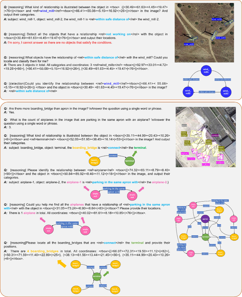
In addition to the basic explanations provided in the main paper, we believe that our complex comprehension tasks proposed here surpass existing region-level tasks in several aspects. The instruction templates for constructing questions for Relation Detection, Relation Reasoning, Object Detection and Object Reasoning tasks are shown in Table A8 and Table A9. For Region-Level SGG and Image-Level SGG tasks, we use the same instructions for detailed region caption and detailed image caption, respectively, but add the prefix [grounding] for them. More visual examples can be found in Figure A1.
Appendix C Details about Datasets
C.1 Additional Datasets for Training
We additionally collect and convert about 365k instruction samples from existing public datasets, the specific source data quantities are shown in Table A10, and the specific conversion methods are described below. For GeoChat-Instruction [25], we select its image description and multi-turn conversation portions based on the DOTA [40], DIOR [54], and FAIR1M [55] datasets to enhance the overall perception of the images.
| Dataset | Samples | Task Type | Specific Format |
| NWPU-RESISC-45 [49] | 9000 | SC | Classify the given image in one of the following classes. |
| UCM-Landuse [50] | 2100 | ||
| RSITMD [51] | 948 | ||
| EarthVQA [52] | 145368 | VQA | Answer in one word or a short phrase. |
| RSVQA-LR [42] | 47173 | ||
| FloodNet-VQA[53] | 4056 | ||
| DOTA-v2.0 [40] | 20000 | OD | [detection] |
| FAIR1M [55] | 40000 | ||
| Geochat-Instruction [25] | 96355 | IC, MT | - |
C.2 Datasets for Evaluation
Details of the public datasets used for evaluation are shown in Table A11. If a dataset has a clearly defined test set, we use its test set for zero-shot or fine-tuning performance evaluation. Otherwise, we typically use the entire dataset for evaluation.
Appendix D Detailed Results on Benchmarks
First, we provide additional details on the experimental setup. We use LoRA fine-tuning with the rank set to 64. We utilize 4 GPUs for training with the total batch size set to 128 and the learning rate is . The ‘cosine’ learning rate schedule is employed with a warmup ratio of 0.03, and the training was conducted for 1 epoch.
D.1 FIT-RSFG Benchmark
We list the detailed results of the FIT-RSFG benchmark based on the FIT-RS dataset and the evaluation metrics used. The detailed results are shown in Table A12. The IoU threshold for evaluating the mAP metric is set to 0.25, considering that in the SGG task, the correctness of the category is more emphasized for the triplet matching. After fine-tuning, the model’s performance on some challenging tasks improved significantly. Moreover, the overall accuracy distribution aligns with the progressive difficulty we designed for the tasks.
| Task Type | Task | Metric | LLaVA1.5-7B (ZS) | GeoChat (ZS) | SkySenseGPT (FT) |
|---|---|---|---|---|---|
| IC | Detailed Image Caption | BLEU-1 | 15.38 | 8.79 | 27.31 |
| BLEU-2 | 13.05 | 4.36 | 15.64 | ||
| BLEU-3 | 6.23 | 1.88 | 7.95 | ||
| BLEU-4 | 2.93 | 0.83 | 4.32 | ||
| METEOR | 10.55 | 4.23 | 12.91 | ||
| ROUGE_L | 20.57 | 10.55 | 23.16 | ||
| GPT-eval | 4.30 | 4.06 | 6.00 | ||
| RC | Detailed Region Caption | BLEU-1 | 14.70 | 14.55 | 75.82 |
| BLEU-2 | 6.63 | 8.66 | 71.42 | ||
| BLEU-3 | 2.33 | 4.63 | 67.71 | ||
| BLEU-4 | 0.63 | 1.97 | 64.05 | ||
| METEOR | 10.66 | 8.80 | 43.69 | ||
| ROUGE_L | 15.67 | 14.02 | 71.86 | ||
| VQA | Visual Question Answering | Count-Acc | 27.75 | 31.64 | 46.49 |
| Pre-Acc | 81.91 | 51.70 | 92.82 | ||
| Comp-Acc | 55.29 | 64.13 | 82.54 | ||
| Rel-Acc | 69.40 | 66.40 | 90.18 | ||
| Ave Acc | 58.59 | 53.47 | 79.76 | ||
| SC | Multi-Label Scene Classification | Scene Acc | 56.18 | 42.27 | 82.23 |
| Obj-Precision | 19.04 | 9.10 | 77.28 | ||
| Obj-Recall | 9.69 | 41.89 | 66.40 | ||
| Obj-F1-Score | 12.84 | 14.95 | 71.43 | ||
| CC | Relation Detection | F1-Score | Failed | Failed | 88.68 |
| Relation Reasoning | F1-Score | Failed | Failed | 74.33 | |
| Object Detection | mAP | Failed | 6.13 | 27.40 | |
| Object Reasoning | mAP | Failed | Failed | 5.71 | |
| Region-Level SGG | Recall | Failed | Failed | 17.01 | |
| Mean Recall | Failed | Failed | 4.05 | ||
| Image-Level SGG | Recall | Failed | Failed | 9.60 | |
| Mean Recall | Failed | Failed | 3.59 | ||
| mAP | Failed | Failed | 12.99 | ||
| MT | Multi-Turn Conv | GPT-eval | 2.74 | 3.64 | 6.60 |
D.2 FIT-RSRC Benchmark
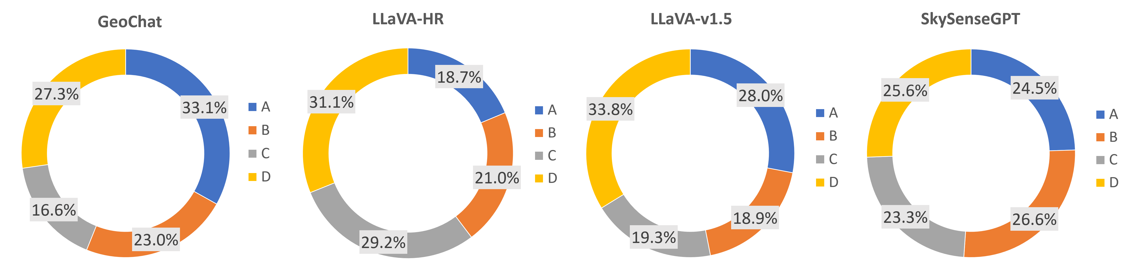
In the FIT-RSRC benchmark, we construct four types of questions (relationship, object, subject, existence) each accounting for 25%, with negative answers distributed within each type. The length of each question option is 4-5, with 87.5% of questions having 4 options and 12.5% having 5 options. To better analyze the prediction accuracy of the evaluated LMMs, we count the distribution of answers for all 4-option questions across the four models, as shown in Figure A2. It can be seen that the existing LMMs show a bias towards a certain option (option D), whereas SkySenseGPT exhibits less bias.
Additionally, we present the carefully crafted preset commonsense word lists, created by human experts with the assistance of GPT-4. These lists include the subject-relation and relation-object word lists, as shown in Table A13 and Table A14. When generating high-quality distractor options, all generated content is cross-checked against these word lists to ensure that incorrect options cannot be identified solely based on the text. This ensures the high quality of the FIT-RSRC benchmark.