Quantifying Geospatial in the Common Crawl Corpus
Abstract.
Large language models (LLMs) exhibit emerging geospatial capabilities, stemming from their pre-training on vast unlabelled text datasets that are often derived from the Common Crawl corpus. However, the geospatial content within CC remains largely unexplored, impacting our understanding of LLMs’ spatial reasoning. This paper investigates the prevalence of geospatial data in recent Common Crawl releases using Gemini, a powerful language model. By analyzing a sample of documents and manually revising the results, we estimate that between 1 in 5 and 1 in 6 documents contain geospatial information such as coordinates and street addresses. Our findings provide quantitative insights into the nature and extent of geospatial data within Common Crawl, and web crawl data in general. Furthermore, we formulate questions to guide future investigations into the geospatial content of available web crawl datasets and its influence on LLMs.
1. Introduction
Recent studies have found that large language models (LLMs) may have some knowledge and understanding of physical space. Gurnee and Tegmark (Gurnee and Tegmark, 2024) demonstrated that Llama-2 learned linear representations of space at various scales, such as landmarks and cities; the authors even identified specific nodes in the model’s architecture that are responsible for this behaviour. Bhandari et al. (Bhandari et al., 2023) probed Llama and several smaller language models for geocoding abilities and geospatial awareness, showing that larger and more sophisticated models have better abilities to synthesise geospatial knowledge from pre-training texts. Mai et al. (Mai et al., 2023) demonstrated superior performance of the GPT-family LLMs on toponym recognition and location description recognition tasks, with few-shot learning often performing on par with the specialised, state-of-the-art named entity recognition (NER) models.
It is generally accepted that language models acquire most of their knowledge during the unsupervised pre-training process, when large amounts of unlabelled and unstructured text are fed into the model (Radford et al., 2018). The Common Crawl corpus111https://commoncrawl.org/ (CC) is the largest free web crawl dataset that powers many smaller, higher-quality datasets such as OSCAR222https://oscar-project.org/ (Suárez et al., 2021), CC-100333https://huggingface.co/datasets/cc100, Colossal Cleaned Crawl Corpus (C4)444https://huggingface.co/datasets/c4 (Raffel et al., 2020), and RefinedWeb555https://huggingface.co/datasets/tiiuae/falcon-refinedweb (Penedo et al., 2023), which are often used in pre-training of LLMs.
Given the importance of CC in the field of generative AI and the growing concerns over the biases and ethics of the generative AI models, it is not surprising the corpus has been analysed for undesirable content such as hate speech and sexually explicit content (Luccioni and Viviano, 2021; Raffel et al., 2020), and its derivative datasets were analysed for general quality (Kreutzer et al., 2022; Dodge et al., 2021; Birhane et al., 2021). While the geospatial bias of LLMs has been subject to multiple investigations (Moayeri and Feizi, 2024; Manvi et al., 2024; Fulman et al., 2024), to our knowledge, no attempts were made to look into the geospatial contents of CC.
In this paper, we aim to fill in this gap by quantifying the number of geospatial files found in recent CC releases, as well as estimating the share of traditional web documents (for example, HTML and XML files) that contain geospatial information, such as coordinates or street addresses. We believe that any debate about the emergent geospatial capabilities of LLMs cannot be complete without knowing the prevalence of geospatial content in the pre-training text corpus.
In the following section, we will present an overview of existing literature quantifying various types of content in CC and the derived datasets. We will then suggest our method of quantifying geospatial content in CC, and present our findings based on three CC releases spaced out over the last five years.
2. Related work
In 2012, Mühleisen and Bizer (Mühleisen and Bizer, 2012) suggested a pipeline to extract structured data, such as Microformats666https://developer.mozilla.org/en-US/docs/Web/HTML/microformats, RDFa777https://www.w3.org/TR/rdfa-primer/ and Microdata888https://developer.mozilla.org/en-US/docs/Web/HTML/Microdata, from CC. The authors estimated that 6% of the HTML pages found in the 2009/10 version of CC contained at least one type of structured data, increasing to 12% in the February 2012 version. Such a jump is not surprising given the exploding popularity of structured data on the web since their creation in mid-2000s (Ruth et al., 2013). According to (Mühleisen and Bizer, 2012), only about 2% of RDFa and 8% of Microdata objects contained geographical information.
To our knowledge, no other research focused on quantifying geospatial in CC and its derivative datasets. When it comes to other types of content, in 2021, Dodge et al. (Dodge et al., 2021) claimed to be some of the first researchers to analyse the C4 dataset, which is a subset of CC (Raffel et al., 2020). They identified a large number of patents, documents coming from the US military websites, and machine-generated text, and concluded that the text from and about minority individuals that is present in CC is disproportionately removed from C4. In the same year, Luccioni and Viviano (Luccioni and Viviano, 2021) randomly sampled 1% of the documents in a single CC release, and applied n-grams, HateSonar999https://github.com/Hironsan/HateSonar, and DE-LIMIT101010https://github.com/hate-alert/DE-LIMIT methods to estimate the prevalence of hate speech in sampled documents at 4.02% to 6.38%, and the prevalence of sexually explicit content at between 0.73% and 2.36%. In a somewhat peculiar exploration in 2014, van Hague et al. (Van Hage et al., 2014) identified the frequency of numbers found in the 2012 version of CC, showing that the (overwhelmingly positive) numbers found across web pages do follow the Power law distribution.
These works gave us insight into how researchers approach the problem of analysing and quantifying phenomena in large text corpora, and we propose our own method of quantifying geospatial in CC in the following section.
3. Method
Our aim is to estimate what share of documents in a typical CC release contains any geospatial information as defined in the next subsections. We deliberately avoid labelling and then quantifying the actual geospatial text as our delineation criteria and judgement of relevance would get extremely complex.
3.1. About Common Crawl
Common Crawl is a San-Francisco based non-profit organisation. Established in 2007, its goal is to ‘make wholesale extraction, transformation, and analysis of open web data accessible to researchers’ (Crawl, 2024). The released datasets comprise the world’s largest free corpus of scraped web data (Baack, 2024), estimated to contain about 250 billion pages, with between 3 and 5 billion added each month (Crawl, 2024).
The datasets are released every one-two months, and are freely available via S3 and HTTP protocols111111https://data.commoncrawl.org. Each release is divided into 300 Web Archive (WARC) chunks (files) for easier access, and accompanied by the index with relevant metadata on each file, such as file’s original URL, MIME-type, and content length. One can obtain individual scraped web documents from the WARC chunks directly from the Common Crawl servers, as we showed in our recent work (Ilyankou et al., 2024):
requests.get(
    f’https://data.commoncrawl.org/{warc_file}’
    headers={
        ’Range’: f’bytes={offset}-{offset+length-1}’
    }
)
In the code snippet above, we use requests Python library121212https://docs.python-requests.org/en/latest/index.html to retrieve an individual scraped web file from a CC warc_file using the Range HTTP header, only reading the bytes of the relevant file by knowing its location within the warc_file, including the offset from the start of the warc_file, and its length in bytes.
In this work, we will focus on three CC releases spanning the last five years, CC-MAIN-{2019-09,2021-39,2024-10}.
3.2. What constitutes geospatial
The vast majority of the files found in CC are standard web pages, such as HTML and XML pages. In fact, the share of CC files that are exclusively geospatial, such as .geojson or .kml, is only roughly 0.003-0.004%. Table 1 shows all geospatial MIME types that we were able to identify from the index of the three relevant CC releases. Therefore, our aim is to estimate the prevalence of geospatial content in predominantly non-geospatial files.
| CC Release | |||
| MIME file type | 2019-09 | 2021-39 | 2024-10 |
| app./geo+json | 0 | 11 | 1 |
| app./gml+xml | 232 | 80 | 333 |
| app./gpx+xml | 6,071 | 13,144 | 16,951 |
| app./tcx+xml | 12 | 0 | 0 |
| app./vnd.garmin.gpx+xml | 1 | 0 | 1 |
| app./vnd.garmin.tcx+xml | 4 | 0 | 0 |
| app./vnd.geo+json | 1 | 0 | 0 |
| app./vnd.google-earth.gpx+xml | 0 | 16 | 57 |
| app./vnd.google-earth.kml+xml | 67,982 | 67,797 | 108,563 |
| app./vnd.google-earth.kmz | 14,870 | 12,849 | 12,124 |
| app./vnd.openstreetmap.data+xml | 0 | 172 | 70 |
| app./vnd.topografix.gpx+xml | 2 | 0 | 49 |
| app./x-shapefile | 512 | 219 | 961 |
| text/gpx+xml | 2 | 2 | 15 |
| text/x-gpx+xml | 0 | 0 | 1 |
| text/xml+georss | 4 | 0 | 0 |
| Total geo files | 89,693 | 94,290 | 139,126 |
| All docs in release | 2914M | 2930M | 3107M |
| Geo files as % of all docs | 0.003 | 0.003 | 0.004 |
In the Manual of Geospatial Science and Technology, Bossler defines geospatial data as ‘features tied to the surface of the earth by coordinates, addresses, or other means’ (Bossler, 2010). Thus, we focus on two elements:
-
•
coordinates, such as latitude-longitude pairs or easting-northing of the British National Grid, whether or not they are accompanied by an address or a location description, and
-
•
street addresses, specific enough so that they can be geocoded into a point.
We do not count derivative location systems such as what3words131313https://what3words.com or geohash141414https://geohash.org/ as valid for our purposes. (In real life, these are typically accompanied by traditional addresses or coordinates, so we are likely to still count the document.) We exclude simple mentions of landmarks, such as ‘The White House’, unless they are accompanied by an address (e.g., ‘The White House, 1600 Pennsylvania Avenue NW, Washington, DC’ or even simply ‘The White House, Washington DC’). This is to ensure we don’t count documents that mention landmarks in passing.
We do not discriminate against real and fictional addresses. For example, we count ‘123 Main Street¡br/¿New York, NY 10001’ as a valid address even though we are certain it is used as a filler. Similarly, we do not check if latitude-longitude pairs are valid as long as it is clear the pair of numbers represents physical coordinates. We do, however, exclude the coordinates of the Null Island (0,0) as those are often used for map initialisation and are not meaningful otherwise (Juhasz and Mooney, 2022), as well as astronomical coordinates of celestial bodies where possible.
3.3. Identifying coordinates and addresses
In web documents, the coordinates most commonly appear inside Google Maps links, inside JavaScript code snippets for map initialisation or marker locations, or as part of <meta> tags or structured documents (e.g., Schema.org151515https://schema.org/):
https://maps.google.co.jp/maps?q=35.6655165,139.7284844

new google.maps.LatLng(38.674594,15.889066)

<meta name="geo.position" content="48.85837;2.294481" />

{
  "@type": "GeoCoordinates",
  "latitude": "35.935775",
  "longitude": "-75.612923"
}
In general, identifying coordinates can be performed using regular expressions, as those are typically expressed as pairs of numbers. For example, latitudes and longitudes are typically expressed as precise numbers between and , respectively. However, any regex pattern is likely to produce false positive matches, such as scientific numbers () or unusually formatted phone numbers (e.g., ). In addition, we occasionally see coordinates expressed in minutes and seconds, such as ‘N 56° 59’ 55” E 009° 19’ 33,7”’, as well as those expressed using various national grid systems, such as positive integers representing easting and northing in the British National Grid161616https://britishnationalgrid.uk/. Adding more regular expressions to capture all these cases is likely to produce even more false positives in different languages, which will be laborious to classify manually.
Identifying street addresses is much more challenging. Addresses may or may not contain digits or punctuation, be expressed as a single string or over multiple HTML tags or JSON fields. Below are some examples of addresses we’ve encountered in the sampled CC documents:
Montevideo 938, 3piso - CABA
<meta itemprop="address" content="4/64-66 Castlereagh St.">
"address": {
"@type": "PostalAddress",
"addressCountry": "RO",
"addressLocality": "Rosu",
"addressRegion": "Ilfov",
"streetAddress": "Nuferilor 16a"
}
<span itemprop="streetAddress">12417 Woodgreen St</span>
<span itemprop="addressLocality">Los Angeles</span>
<span itemprop="addressRegion">CA</span>
Pantile House | Newlands Drive | Witham | CM8 2AP | UK
http://maps.google.ca/maps?...&q=800+Steeles+Ave+W
+Vaughan,+York+Regional+Municipality,+Ontario&...
In addition to varied formats, many texts are in non-Latin scripts, such as Cyrillic, Arabic, Greek, and Chinese/Japanese/Korean characters. Popular open-source software packages such as pyap171717https://github.com/vladimarius/pyap or libpostal181818https://github.com/openvenues/libpostal usually only work with shorter strings and are typically limited to particular countries. In 2010, Chang and Li (Chang and Li, 2010) proposed MapMarker, a sequence labelling algorithm coupled with pattern mining, to perform postal addresses extraction from web texts, achieving the F-score of 91%. In 2013, Schmidt et al. (Schmidt et al., 2013) suggested a hybrid approach using patterns and data from gazetteers to extract addresses from web documents, showing high recall and precision. However, in their approach HTML tags are removed from the documents, which is not ideal given that geospatial information can be housed inside <meta> and other tags, as well as inside JavaScript code snippets and JSON files. In 2018, Efremova et al. (Efremova et al., 2018) introduced a geo-tagging framework that employs n-grams, sliding windows, and a Support Vector Machine classifier to extract addresses from CC documents, achieving precision and recall of 91% and 93% respectively. Named entity recognition (NER) tools such as spaCy191919https://spacy.io/ can also be trained to extract addresses, yet this would require a labelled training set.
Inspired by the needle-in-a-haystack evaluation task for LLMs202020This popular GitHub repository contains needle-in-a-haystack benchmark tests for LLMs: https://github.com/gkamradt/LLMTest_NeedleInAHaystack, in which long-context window LLMs are tasked to retrieve particular bits of information from a long document, such as an article or a book, we decided to employ a language model to retrieve both coordinates and addresses from web documents (if they exist), and then manually review the results. LLMs are excellent zero-shot learners and have demonstrated superior performance in named entity recognition and text classification tasks (Xie et al., 2023; Zhou et al., 2024; Wei et al., 2022; Team, 2024), so we believe they are better suited to identify the presence of geospatial in multilingual CC documents than traditional, language-and country-specific methods.
3.4. Gemini 1.5 for geospatial detection
Gemini 1.5 is one of the few LLMs currently capable of handling inputs of up to 1 million tokens, and has shown to perform well in the needle-in-a-haystack retrieval task (Team, 2024). The context window consideration is important given the web documents found in CC can be lengthy. Figure 1 shows the histogram of lengths of sampled documents that we used in our analysis. While the median and means lengths range from ca. 17k to 55k tokens between the releases, the length distribution is heavily skewed to the right, with some documents reaching up to 1M tokens.
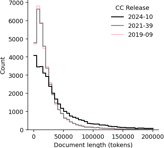
Web document length in tokens (includes query text)
The prevalence of geospatial data in CC documents
In this paper, we use the Gemini 1.5 Flash version, which has the most generous free tier API usage allowance of 1,500 requests per day. At the time of running our experiment, the pay-as-you-go tier with up to 10,000 requests per day has been announced, but is not yet available212121According to https://ai.google.dev/pricing, the pay-as-you-go pricing for Gemini 1.5 Flash and Pro will become available on May 30, 2024.
After some instruction-tuning on sampled web documents from CC, we adapted the following query:
Document: “‘{cc_web_document}”’ Question: Does the document enclosed in triple quotes contain geographic coordinates, such as a latitude- longitude pair, or a street address that can be used to identify a physical location such as a building? If so, return a few examples. If not, just say ‘None’.
We assume the web documents do not contain adverse instructions that may confuse the language model.
Initially, we wanted to use separate queries for coordinates and street addresses; however, due to the API limitations, we decided to combine both elements into a single query to half the execution time after confirming that Gemini responds with both categories of examples (coordinates, addresses) where both are present in the document.
Below is an example of a Gemini response to the query for the document that contains both a pair of coordinates and a street address:
The document contains the following geographic information: * **Latitude-Longitude Pair:** 45.3702375; -85.0128508 * **Street Address:** 1889 Petoskey Harbor Road * **City, State, Zip Code:** Petoskey, MI 49770
3.5. Determining sample size
Previous studies that analysed CC have done so on many randomly sampled documents (often an arbitrary, but large and round number). For example, Luccioni and Viviano (Luccioni and Viviano, 2021) sampled 1% of the English language documents in a single CC release, which amounted to just under 6 million documents. Dodge et al. (Dodge et al., 2021) randomly sampled and clustered 100,000 documents from CC that were block-listed by (and hence did not make it into) the C4 dataset.
However, in our task we are unable to utilise fast algorithms such as keyword lookup, n-grams, or K-Means. We are limited by the number of API requests we can make; in addition, each query takes Gemini between several seconds to several minutes to be processed. We need to choose the smallest yet scientifically sound sample size, and so we decided to use Cochran’s formula (1) (Bartlett et al., 2001). The formula is used to calculate the ideal sample size that estimates population with a desired level of precision and a particular confidence interval. It is commonly used in social sciences to estimate the number of people to survey. We use the version of Cochran’s formula modified for very large (or infinite) population because a single CC release contains billions of web pages:
| (1) |
where is the desired level of precision (we chose 0.005 to get the estimate within ), is the estimated proportion of the population that possesses a characteristic (in our case, this is what we are trying to determine, so we leave it at as is customary in such situations), and is the z-value of our chosen confidence interval ( for 95% confidence).
Therefore, according to the formula, we need to sample 38,416 documents to get a prevalence estimate approximated at with a confidence interval of 95%. We decided to sample 39,900 documents (133 random documents from each of 300 parts) from each of 3 individual CC releases. The headroom of 1,400+ documents is to account for the fact that Gemini occasionally fails to process queries, either due to an Internal error (code 500) or by marking the query as Unsafe. At the end, we queried the language model times, and then manually reviewed all responses.
3.6. Revising Gemini responses
We manually reviewed each Gemini response that is longer than 1 or 2 tokens (‘None’ or ‘None.’, respectively) in order to check that we are satisfied with the quality of the examples returned, as well as to distinguish whether the document contains an address, or coordinates, or both.
To ensure Gemini did not hallucinate the examples, that is, made up random coordinates or addresses that do not exist in the source document, we manually checked a random sample of 100 documents for which the language model returned geospatial examples. We were able to locate all examples provided by Gemini in the corresponding source documents.
In order to check for false negatives, that is, the documents for which Gemini returned None that may contain geospatial data, we manually reviewed a random sample of 100 such documents. Using Google Translate222222https://translate.google.com when needed, we were unable to identify street addresses or coordinates in all cases.
4. Findings
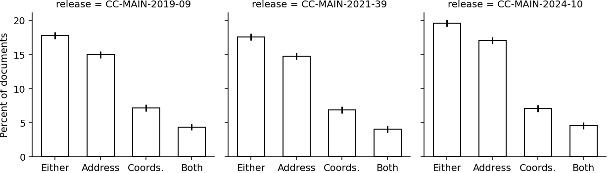
Our estimate of the prevalence of geospatial data in CC documents is shown in Figure 2. Overall, when analysing the three CC releases from between 2019 and 2024, we find that 18.3% of the documents contain either a street address or a pair of coordinates (or both), 15.6% of the documents contain a street address, 7.1% of the document contain a pair of coordinates, and 4.4% of the documents have both an address and a pair of coordinates. These estimates are fairly consistent between the releases.
Almost 28% of the web documents that contain an address also contain a pair of coordinates, and almost 62% of the documents that contain coordinates also contain an address. (It is worth noting that the coordinate and the address found in the same document do not necessarily refer to the same location.)
The most pronounced single source of coordinates in web documents is Google Maps URLs that encode latitude and longitude (occasionally with the address, too). Examples of these can be found in the Identifying coordinates and addresses subsection.
On several occasions, Gemini judged that an IP address or a phone number or a named landmark (such as a theatre) is sufficient to locate the place. In some cases, it also returned the astronomical coordinates of celestial bodies. However, these did not meet our definition of geospatial described in the What constitutes geospatial subsection, so we excluded them from the final count.
5. Conclusion
In this paper, we analysed the contents of CC for the presence of geospatial data. Using Gemini and manual verification, we estimated that about 18.3% of all documents in recent CC releases contain a street address or a pair of coordinates. Thus, we conclude that geospatial data is fairly well represented in mostly unstructured CC documents.
Therefore, it is not surprising that LLMs exhibit some geospatial capabilities, such as the knowledge of distances and directions between landmarks and other locations. We suggest further research into the accuracy and quality of the geospatial data in CC documents is needed to better understand the geospatial biases that LLMs exhibit. We also recognise that coordinates and addresses, being specific point-level bits of information, are not the only way LLMs learn the physical space; the context of the web pages where geospatial data is found is also very important. This may include textual descriptions of places, both objective and subjective, such as those describing the surroundings or the experience of the visitors or the activities happening in the area.
Given the scale of CC, which advertises itself as having the total of ‘over 250 billion documents’232323https://commoncrawl.org/, we can estimate that 45 billion pages are likely to contain geospatial data. In some cases, the geospatial data will be context rich, making CC a potential goldmine for domain-specific geospatial datasets that can be used to train or fine-tune LLMs on geospatial tasks.
Acknowledgements.
This work was supported by the Ordnance Survey, and the Engineering and Physical Sciences Research Council [grant no. EP/Y528651/1]. The authors would also like to thank Chuang Liu, Zhengxiang Shi, Meihui Wang, Xiaowei Gao, Jerome Ramos, Hao Chen, Xinglei Wang, and Junyuan Liu of UCL SpaceTimeLab for their help facilitating access to the Gemini API.References
- (1)
- Baack (2024) Stefan Baack. 2024. Training Data for the Price of a Sandwich: Common Crawl’s Impact on Generative AI. (Feb. 2024).
- Bartlett et al. (2001) James E Bartlett, Joe W Kotrlik, and Chadwick C Higgins. 2001. Organizational Research: Determining Appropriate Sample Size in Survey Research. (2001).
- Bhandari et al. (2023) Prabin Bhandari, Antonios Anastasopoulos, and Dieter Pfoser. 2023. Are Large Language Models Geospatially Knowledgeable?. In Proceedings of the 31st ACM International Conference on Advances in Geographic Information Systems (SIGSPATIAL ’23). Association for Computing Machinery, New York, NY, USA, 1–4. https://doi.org/10.1145/3589132.3625625
- Birhane et al. (2021) Abeba Birhane, Vinay Uday Prabhu, and Emmanuel Kahembwe. 2021. Multimodal datasets: misogyny, pornography, and malignant stereotypes. http://arxiv.org/abs/2110.01963 arXiv:2110.01963 [cs].
- Bossler (2010) John Bossler. 2010. Manual of Geospatial Science and Technology. CRC Press. Google-Books-ID: UdZ3uDekqwwC.
- Chang and Li (2010) Chia-Hui Chang and Shu-Ying Li. 2010. MapMarker: Extraction of Postal Addresses and Associated Information for General Web Pages. In 2010 IEEE/WIC/ACM International Conference on Web Intelligence and Intelligent Agent Technology. IEEE, Toronto, AB, Canada, 105–111. https://doi.org/10.1109/WI-IAT.2010.64
- Crawl (2024) Common Crawl. 2024. Common Crawl - Open Repository of Web Crawl Data. https://commoncrawl.org/
- Dodge et al. (2021) Jesse Dodge, Maarten Sap, Ana Marasović, William Agnew, Gabriel Ilharco, Dirk Groeneveld, Margaret Mitchell, and Matt Gardner. 2021. Documenting Large Webtext Corpora: A Case Study on the Colossal Clean Crawled Corpus. http://arxiv.org/abs/2104.08758 arXiv:2104.08758 [cs].
- Efremova et al. (2018) Julia Efremova, Ian Endres, Isaac Vidas, and Ofer Melnik. 2018. A Geo-Tagging Framework for Address Extraction from Web Pages. In Advances in Data Mining. Applications and Theoretical Aspects, Petra Perner (Ed.). Springer International Publishing, Cham, 288–295. https://doi.org/10.1007/978-3-319-95786-9_22
- Fulman et al. (2024) Nir Fulman, Abdulkadir Memduhoğlu, and Alexander Zipf. 2024. Evidence for Systematic Bias in the Spatial Memory of Large Language Models. (2024).
- Gurnee and Tegmark (2024) Wes Gurnee and Max Tegmark. 2024. Language Models Represent Space and Time. https://doi.org/10.48550/arXiv.2310.02207 arXiv:2310.02207 [cs].
- Ilyankou et al. (2024) Ilya Ilyankou, James Haworth, and Stefano Cavazzi. 2024. CC-GPX: Extracting High-Quality Annotated Geospatial Data from Common Crawl. http://arxiv.org/abs/2405.11039 arXiv:2405.11039 [cs].
- Juhasz and Mooney (2022) Levente Juhasz and Peter Mooney. 2022. “I Think i Discovered a Military Base in the Middle of the Ocean”—Null Island, the Most Real of Fictional Places. IEEE Access 10 (2022), 84147–84165. https://doi.org/10.1109/ACCESS.2022.3197222
- Kreutzer et al. (2022) Julia Kreutzer, Isaac Caswell, Lisa Wang, Ahsan Wahab, Daan van Esch, Nasanbayar Ulzii-Orshikh, Allahsera Tapo, Nishant Subramani, Artem Sokolov, Claytone Sikasote, Monang Setyawan, Supheakmungkol Sarin, Sokhar Samb, Benoît Sagot, Clara Rivera, Annette Rios, Isabel Papadimitriou, Salomey Osei, Pedro Ortiz Suarez, Iroro Orife, Kelechi Ogueji, Andre Niyongabo Rubungo, Toan Q. Nguyen, Mathias Müller, André Müller, Shamsuddeen Hassan Muhammad, Nanda Muhammad, Ayanda Mnyakeni, Jamshidbek Mirzakhalov, Tapiwanashe Matangira, Colin Leong, Nze Lawson, Sneha Kudugunta, Yacine Jernite, Mathias Jenny, Orhan Firat, Bonaventure F. P. Dossou, Sakhile Dlamini, Nisansa de Silva, Sakine Çabuk Ballı, Stella Biderman, Alessia Battisti, Ahmed Baruwa, Ankur Bapna, Pallavi Baljekar, Israel Abebe Azime, Ayodele Awokoya, Duygu Ataman, Orevaoghene Ahia, Oghenefego Ahia, Sweta Agrawal, and Mofetoluwa Adeyemi. 2022. Quality at a Glance: An Audit of Web-Crawled Multilingual Datasets. Transactions of the Association for Computational Linguistics 10 (Jan. 2022), 50–72. https://doi.org/10.1162/tacl_a_00447 arXiv:2103.12028 [cs].
- Luccioni and Viviano (2021) Alexandra Sasha Luccioni and Joseph D. Viviano. 2021. What’s in the Box? A Preliminary Analysis of Undesirable Content in the Common Crawl Corpus. http://arxiv.org/abs/2105.02732 arXiv:2105.02732 [cs].
- Mai et al. (2023) Gengchen Mai, Weiming Huang, Jin Sun, Suhang Song, Deepak Mishra, Ninghao Liu, Song Gao, Tianming Liu, Gao Cong, Yingjie Hu, Chris Cundy, Ziyuan Li, Rui Zhu, and Ni Lao. 2023. On the Opportunities and Challenges of Foundation Models for Geospatial Artificial Intelligence. http://arxiv.org/abs/2304.06798 arXiv:2304.06798 [cs].
- Manvi et al. (2024) Rohin Manvi, Samar Khanna, Marshall Burke, David Lobell, and Stefano Ermon. 2024. Large Language Models are Geographically Biased. http://arxiv.org/abs/2402.02680 arXiv:2402.02680 [cs].
- Moayeri and Feizi (2024) Mazda Moayeri and Soheil Feizi. 2024. WorldBench: Quantifying Geographic Disparities in LLM Factual Recall. https://openreview.net/forum?id=fubvUIBggI
- Mühleisen and Bizer (2012) Hannes Mühleisen and Christian Bizer. 2012. Web Data Commons – Extracting Structured Data from Two Large Web Corpora. (2012).
- Penedo et al. (2023) Guilherme Penedo, Quentin Malartic, Daniel Hesslow, Ruxandra Cojocaru, Alessandro Cappelli, Hamza Alobeidli, Baptiste Pannier, Ebtesam Almazrouei, and Julien Launay. 2023. The RefinedWeb Dataset for Falcon LLM: Outperforming Curated Corpora with Web Data, and Web Data Only. http://arxiv.org/abs/2306.01116 arXiv:2306.01116 [cs].
- Radford et al. (2018) Alec Radford, Karthik Narasimhan, Tim Salimans, and Ilya Sutskever. 2018. Improving Language Understanding by Generative Pre-Training. (2018).
- Raffel et al. (2020) Colin Raffel, Noam Shazeer, Adam Roberts, Katherine Lee, Sharan Narang, Michael Matena, Yanqi Zhou, Wei Li, and Peter J. Liu. 2020. Exploring the Limits of Transfer Learning with a Unified Text-to-Text Transformer. http://arxiv.org/abs/1910.10683 arXiv:1910.10683 [cs, stat].
- Ruth et al. (2013) Luke Ruth, David Wood, Marsha Zaidman, and Michael Hausenblas. 2013. Linked Data: Structured data on the Web. Simon and Schuster. Google-Books-ID: hTozEAAAQBAJ.
- Schmidt et al. (2013) Sebastian Schmidt, Simon Manschitz, Christoph Rensing, and Ralf Steinmetz. 2013. Extraction of Address Data from Unstructured Text using Free Knowledge Resources. In Proceedings of the 13th International Conference on Knowledge Management and Knowledge Technologies. ACM, Graz Austria, 1–8. https://doi.org/10.1145/2494188.2494193
- Suárez et al. (2021) Pedro Javier Ortiz Suárez, Benoît Sagot, and Laurent Romary. 2021. Asynchronous Pipeline for Processing Huge Corpora on Medium to Low Resource Infrastructures. (2021).
- Team (2024) Gemini Team. 2024. Gemini 1.5: Unlocking multimodal understanding across millions of tokens of context. arXiv:2403.05530 [cs.CL]
- Van Hage et al. (2014) Willem Robert Van Hage, Thomas Ploeger, and Jesper Hoeksema. 2014. Number frequency on the web. In Proceedings of the 23rd International Conference on World Wide Web. ACM, Seoul Korea, 571–572. https://doi.org/10.1145/2567948.2576962
- Wei et al. (2022) Jason Wei, Maarten Bosma, Vincent Y. Zhao, Kelvin Guu, Adams Wei Yu, Brian Lester, Nan Du, Andrew M. Dai, and Quoc V. Le. 2022. Finetuned Language Models Are Zero-Shot Learners. http://arxiv.org/abs/2109.01652 arXiv:2109.01652 [cs].
- Xie et al. (2023) Tingyu Xie, Qi Li, Jian Zhang, Yan Zhang, Zuozhu Liu, and Hongwei Wang. 2023. Empirical Study of Zero-Shot NER with ChatGPT. (2023).
- Zhou et al. (2024) Wenxuan Zhou, Sheng Zhang, Yu Gu, Muhao Chen, and Hoifung Poon. 2024. UniversalNER: Targeted Distillation from Large Language Models for Open Named Entity Recognition. http://arxiv.org/abs/2308.03279 arXiv:2308.03279 [cs].