Field Report on a Wearable and Versatile Solution for Field Acquisition and Exploration
Abstract
This report presents a wearable plug-and-play platform for data acquisition in the field. The platform, extending a waterproof Pelican Case into a 20 kg backpack offers 5.5 hours of power autonomy, while recording data with two cameras, a lidar, an Inertial Measurement Unit (IMU), and a Global Navigation Satellite System (GNSS) receiver. The system only requires a single operator and is readily controlled with a built-in screen and buttons. Due to its small footprint, it offers greater flexibility than large vehicles typically deployed in off-trail environments. We describe the platform’s design, detailing the mechanical parts, electrical components, and software stack. We explain the system’s limitations, drawing from its extensive deployment spanning over 20 kilometers of trajectories across various seasons, environments, and weather conditions. We derive valuable lessons learned from these deployments and present several possible applications for the system. The possible use cases consider not only academic research but also insights from consultations with our industrial partners. The mechanical design including all CAD files, as well as the software stack, are publicly available at https://github.com/norlab-ulaval/backpack_workspace.
I Introduction
Real-life datasets are essential to improve autonomous navigation algorithms [1]. To capture the complexity of the world, these datasets must showcase a wide variety of environments and weather conditions. Several datasets acquired in urban contexts used a standard car equipped with sensors as the acquisition platform [2, 3]. In comparison, off-road environments require specialized ground vehicles to navigate the diversified and challenging terrains [4, 5]. These platforms are usually large and powerful, which makes them hard to deploy without a large team. One solution to simplify off-road data acquisition is to use drones, which are easy to deploy, highly maneuverable, and independent of the terrain. However, their battery life is highly limited, hindering their capacity to travel long distances [6, 7].
On a different path, multiple companies started building wearable mobile solutions, such as the Leica Pegasus Backpack,111https://leica-geosystems.com/products/mobile-mapping-systems/capture-platforms/leica-pegasus-backpack the Mosaic Xplor,222https://www.mosaic51.com/cameras/mosaic-xplor/ and the NavVIS VLX 3.333https://www.navvis.com/vlx-3 These devices are considered top-of-the-line systems but are generally expensive and closed-source. Any project-dependent customization, often needed for research projects, is therefore challenging. Due to difficulties in traversing forest landscapes, the forestry research field has also proposed multiple backpack data acquisition systems. [8] developed a low-cost platform for navigation in forest environments. The platform is equipped with an omnidirectional camera, in addition to an Inertial Measurement Unit (IMU) and a Global Navigation Satellite System (GNSS) antenna. [9] created their version, adding a 3D lidar and a multi-spectral camera. The two proposed designs are good examples of portable platforms but are not built for winter weather when sensors must be protected from the snow and the cold, which can reach as low as . Another version, designed by [10], incorporated an active theodolite prism for ground truth generation from a total station. The system was used in winter but not during snowfall, lacking the necessary protection.
In this paper, we present a technical report on the development of a cost-efficient acquisition platform, depicted in Figure 1. The developed platform is a user-friendly, water-resistant portable backpack that allows the recording of a variety of sensor data, such as images, point clouds, satellite positioning, and inertial data. Built with a small status screen and two control buttons, the system only requires a single operator to be deployed, without the need for an external computer for data acquisition. The small footprint of the acquisition platform allows for the collection of data in narrow and hard-to-access spaces for robotic vehicles. The following sections detail the design process leading to this data-gathering platform. The used material is listed, followed by an analysis of the system’s performances and limitations. The final sections address the lessons learned during the process, and highlight some possible applications for research and industry sectors.
II Platform Details
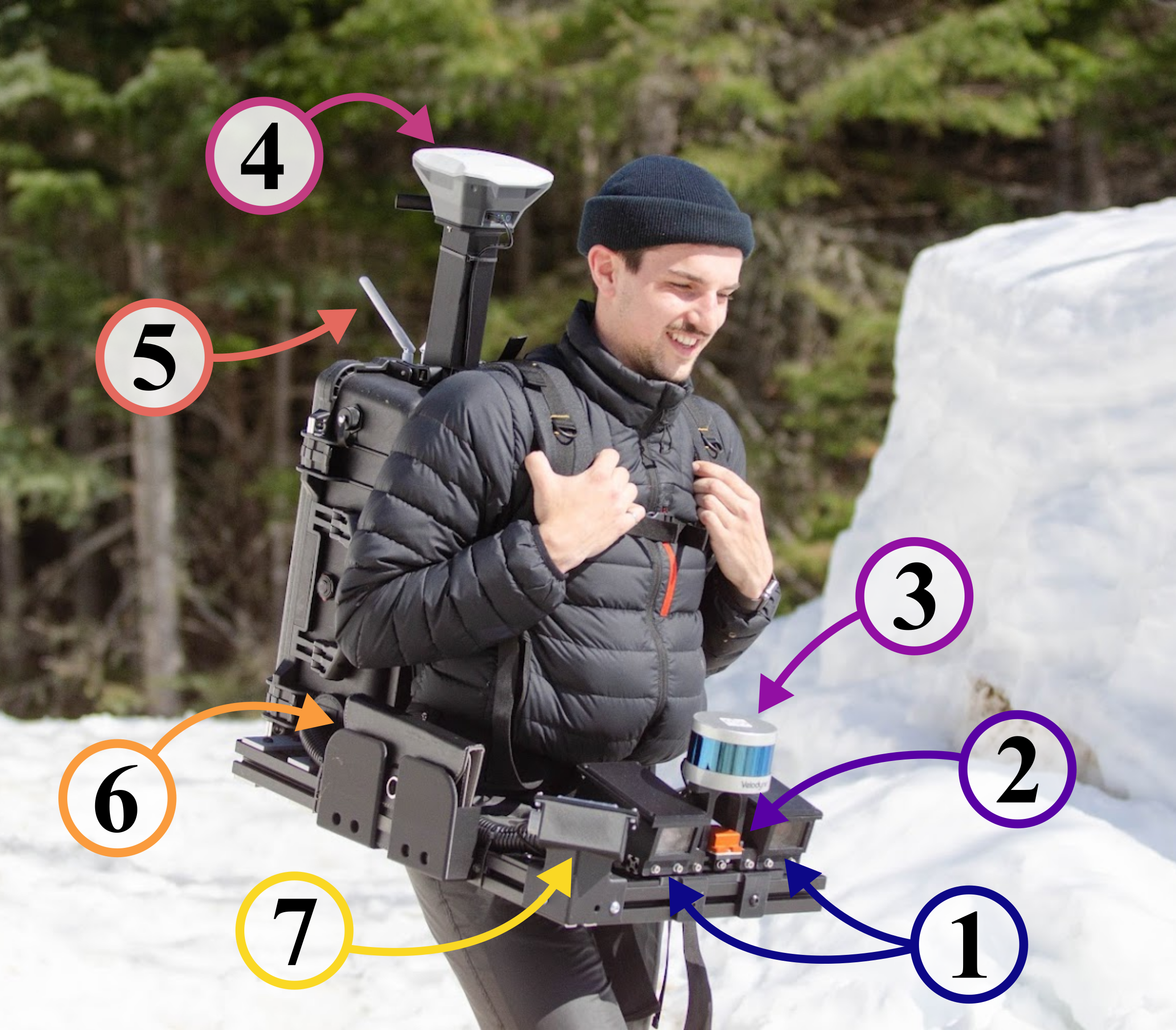
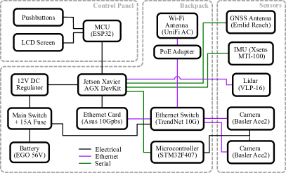
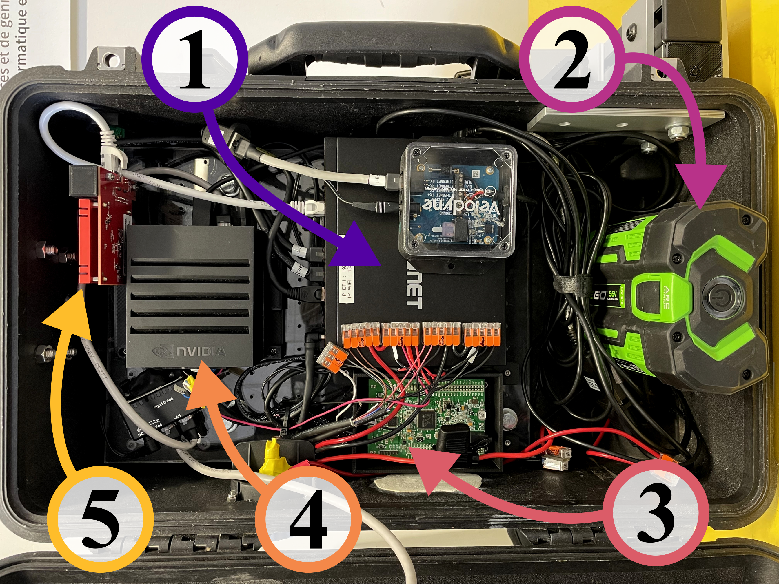
The platform is composed of three main sections: the backpack itself, the sensors, and the control panel. A block diagram of the backpack’s hardware components is presented in Figure 2, where the subsystems and the links between them are displayed. The figure also shows the interface type connecting each module, i.e., electrical, Ethernet, or serial. Note that the final choice of the presented modules was determined after three version iterations of the platform, which were intertwined by outdoor testing and multiple deployments, described in Section II-E and Section IV.
II-A Backpack
The backpack’s core frame is a Pelican Case 1510, which is roughly the size of a person’s back and has the advantage of being water-resistant. The main power comes from a rechargeable Ego battery installed on a custom-made 3D printed connector, depicted in Figure 3. Different battery formats can be used, allowing to adjust the backpack’s weight between and . The lightest battery is and lasts around , while the heaviest is for a total battery life of . The embedded computer is a Jetson Xavier AGX Developer Kit, which records all the sensors’ data directly into a 970 EVO Plus NVMe M.2 SSD of . This computing unit is equipped with two embedded Ethernet interfaces. Resulting from a lack of bandwidth that led to data losses, the computer was complemented with an Asus XG-C100C PCIe card that is connected to a TRENDnet TEG-S762 switch, offering two ports and four ports. For better control over the image acquisition, an STM32F407 microcontroller acts as an external trigger to synchronize the acquisition from both cameras, but also for precise exposure time control. The trigger signal is generated using hardware timers in the microcontroller, providing more robust timing than software-based solutions. Finally, an antenna from Ubiquiti, the UAP-AC-M UniFi AC Mesh AP, is connected to its own Ethernet card, and serves as a hotspot to allow wireless connection into the backpack’s computer.
II-B Sensors
The platform contains four main sensors. For vision, we integrated two industrial cameras from Basler (i.e., the a2A1920-51gcPRO) in a stereo-calibrated configuration with a baseline of and hardware-triggered system using the microcontroller mentioned above. Each camera captures -bit channel images and has a bandwidth, which justifies the Ethernet card upgrade on the Jetson Xavier AGX. In addition to the camera, the platform is equipped with a Velodyne VLP-16 lidar, which also communicates using Ethernet. The lidar is plugged into its own Ethernet card to mitigate any risk of entanglement between signals, leading to loss of information. Finally, the platform is equipped with an Xsens MTI-30 IMU and an Emlid Reach RS+ GNSS receiver.
II-C Control Panel
An ESP32 microcontroller communicates with the Jetson Xavier AGX over USB to display the status of each sensor to the user on an LED screen in front of the platform. It shows four types of messages:
-
•
OFF: The sensor is not used.
-
•
IDLE: The sensor is ready for data acquisition.
-
•
REC: The sensor’s data is being recorded.
-
•
ERR: There is a problem with the sensor.
-
•
CAL: The sensor is undergoing calibration (IMU only).
Finally, the screen also presents the remaining free space on the drive and the cameras’ acquisition rate. The ESP32 is also connected to two push buttons, which allow to start the sensors and to enable the data recording.
II-D Performances Analysis
Based on the components installed in the platform, we analyzed the necessary bandwidth while recording data from all the sensors. The Ethernet transmission rate is examined for each of the three Ethernet cards installed on our Jetson Xavier AGX, i.e., the two embedded interfaces and the external PCIe card. The bandwidth coming from the camera is the highest with around , while the transmission rate from the lidar is around . The last Ethernet card is plugged directly into the Ubiquiti antenna, which uses no bandwidth unless another computer is connected to it for visualization. An analysis of the total CPU load showed that an average of cores are used from the available, while the system uses of RAM during recording.
In relation to the performances, we estimated the energy consumption needed to power all the hardware in the platform. The total consumption is approximately , and is mainly from the computer and the Ethernet switch, using respectively and .
II-E Limitations
A wearable data acquisition platform offers simplified operation, but may lack some features commonly found in standard vehicles. For instance, no odometry data is available because of the absence of wheel encoders, which can be useful for numerous autonomous navigation algorithms. To compensate, the IMU is used to estimate the velocity and the position by integrating the accelerometer values. Since these values drift quickly, the IMU’s odometry estimations are corrected using a 3D map built from the lidar point clouds. The code is available on GitHub.444https://github.com/norlab-ulaval/imu_odom
Maintaining a consistent speed when gathering data is challenging due to human factors. It is demanding to keep the same walking speed on long distances, especially if the desired speed is low. The significant weight, comparable to a 6-year-old child, mainly comes from the enclosure and the aluminum structure. These respectively allow the platform to be resistant to harsh weather and vibrations, thus providing more persistent calibrations. In relation to the weight, the platform can be challenging or impossible to wear if the operator is injured, slowing the data collection. Lastly, oscillations are observed in the sensors’ trajectories because of the walking movements, which can be troublesome for some experiments.
III Lessons Learned
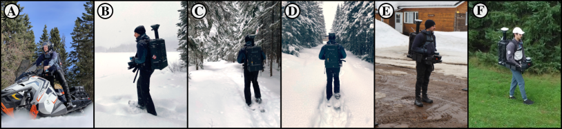
This section gives insights into the development of a robotic acquisition platform based on the problems encountered during the backpack design. These lessons were learned after more than of traveled distance with the backpack in several environment types, as depicted in Figure 4. The system was deployed all year around, facing challenging weather, such as snowstorms, rain, and warm summer days. The platform was also used in three industrial demonstrations, proving its robustness and reliability.
Bandwidth - The first purpose of the backpack was a platform to record camera images easily. Since the two selected industrial cameras communicate at a rate of , it was challenging to obtain the maximum frames per second (FPS) given in the specification sheet. The bandwidth was first limited by the switch, which had per port. The flux from the two cameras being , the transfer bandwidth from the switch to the Jetson Xavier AGX was not sufficient. The effect was worse at first since the lidar was also plugged into the same switch, then it was moved to its independent Ethernet card. After multiple attempts to optimize the communication channels in the switch itself, we came to the conclusion that the best way to develop a robust communication link from the cameras to the main computer was to increase the hardware performance. By adding a Ethernet link, the cameras’ FPS is maximized without any packet loss.
Plug-and-play System - With the intention of not having to transport a computer during data gathering, we added a small LED screen and two buttons as described in Section II-C. The screen allows for real-time updates about the sensors and the computer, giving the user certainty about the recording information. In our case, it is mostly useful to detect malfunctions, such as disconnected sensors, cameras overheating, lidar total obstruction, and GNSS-denied environment. Moreover, displaying the remaining free disk space allows for better time management, especially during long deployments. An Android tablet provides real-time visualization of the images and point clouds, through the ROS-Mobile app,555https://github.com/ROS-Mobile/ROS-Mobile-Android which would not be possible without the high-bandwidth Wi-Fi antenna. This setup proved beneficial to adjust camera parameters in changing environment lighting, since it allows to validate the image quality before a new recording. From our experiences, investing time upfront in a user-friendly platform allows for faster data gathering later on, while a status display provides a more robust and efficient acquisition.
Camera Power Supply - For outdoor data collection, industrial cameras should be protected from rain, dust, and snow using a housing. However, by encasing them, the cameras will often overheat due to a lack of airflow. This effect is enlarged when using Power over Ethernet (PoE) as a power supply source for the cameras, since the provided voltage is higher than the cameras’ rating. The excess is then converted to heat, which increases the ambient temperature surrounding the camera until it hits the protection threshold, causing lag, and even shutdown. We found that powering the camera directly from a standard power cable, instead of using the PoE, alleviates overheating problems.
IV Possible Applications
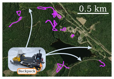
The main reason behind our platform was to develop an easy-to-deploy system, allowing to record on large territory and narrow environments, such as off-trail paths. With our system, a single person collected the BorealHDR dataset [11], which was mostly recorded in winter, at the Montmorency Forest near Quebec City, Canada. The versatility of our platform allowed us to attach it to a snowmobile, gaining speed to cover a large part of the forest, as displayed in Figure 5. In a one-day deployment, we recorded trajectories totaling , on an area of . The characteristics of the platform allowed us to wear snowshoes, which were essential for navigating deep snow. A dataset, such as BorealHDR, would have necessitated more time to collect and a larger team if it had been gathered using a standard autonomous platform.
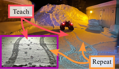
Our system was also used to perform Teach-and-Repeat (TnR), which consists of manually recording a trajectory and repeating it autonomously [12]. We used the Weather-Invariant Lidar-based Navigation (WILN) framework,666https://github.com/norlab-ulaval/wiln developed by [4], where our backpack system was used to record the teach trajectory. Then, we repeated this same trajectory with a half-ton Clearpath Warthog mobile robot. Figure 6 demonstrates the successful trajectory repetition, where the footprints in the snow align with the vehicle tracks imprints.
The presented use cases could be applied in real scenarios, for instance in forest management and inventory. Instead of manually measuring and identifying trees, a similar solution could be used to automatically identify and register the trees with their GNSS coordinates, without needing a specialist on-site. Companies, such as Gaia-AI777https://www.gaia-ai.eco/ and Treeswift,888https://www.treeswift.com/ have already developed wearable platforms for such applications. TnR could also be useful in forestry, where foresters could first walk an uncertain path and then transfer the traveled trajectory to autonomous machinery. Another example would be for resupply missions, since the first crossing is always performed before needing resupplying, which means the trajectory can be recorded and sent to the main base station.
These applications are examples of the challenges that we faced with our platform, but several more applications could benefit from a versatile and easy-to-deploy system for data recording.
V Conclusion
In this work, we presented our wearable acquisition platform for data recording, such as camera images, 3D lidar point clouds, inertial, and GNSS data. This plug-and-play system allows for easy deployments and quick data gathering due to its simple transportability. We presented the platform by dividing it into three main components: the backpack, the sensors, and the control panel. From the experience acquired by developing the system, we presented its limitations and the lessons learned, which we judged useful for the community. Finally, several applications for our acquisition platform were described, giving an idea of the possibilities created by a versatile and user-friendly system.
References
- [1] Yuanzhi Liu et al. “BotanicGarden: A High-Quality Dataset for Robot Navigation in Unstructured Natural Environments” In IEEE Robotics and Automation Letters IEEE, 2024
- [2] Andreas Geiger, Philip Lenz, Christoph Stiller and Raquel Urtasun “Vision meets robotics: The kitti dataset” In The International Journal of Robotics Research 32.11 Sage Publications Sage UK: London, England, 2013, pp. 1231–1237
- [3] Marius Cordts et al. “The cityscapes dataset for semantic urban scene understanding” In Proceedings of the IEEE conference on computer vision and pattern recognition, 2016, pp. 3213–3223
- [4] Dominic Baril et al. “Kilometer-scale autonomous navigation in subarctic forests: challenges and lessons learned” In Field Robotics 2.1 Field Robotics Publication Society, 2022, pp. 1628–1660 DOI: 10.55417/fr.2022050
- [5] Samuel Triest et al. “Tartandrive: A large-scale dataset for learning off-road dynamics models” In 2022 International Conference on Robotics and Automation (ICRA), 2022, pp. 2546–2552 IEEE
- [6] Mohammad Mozaffari et al. “A tutorial on UAVs for wireless networks: Applications, challenges, and open problems” In IEEE communications surveys & tutorials 21.3 IEEE, 2019, pp. 2334–2360
- [7] Ali Rohan et al. “Advanced drone battery charging system” In Journal of Electrical Engineering & Technology 14 Springer, 2019, pp. 1395–1405
- [8] Mariana Batista Campos et al. “A backpack-mounted omnidirectional camera with off-the-shelf navigation sensors for mobile terrestrial mapping: Development and forest application” In Sensors 18.3 MDPI, 2018, pp. 827
- [9] Mona Goebel and D Iwaszczuk “Backpack System for Capturing 3D Point Clouds of Forests” In ISPRS Annals of the Photogrammetry, Remote Sensing and Spatial Information Sciences 10 Copernicus Publications Göttingen, Germany, 2023, pp. 695–702
- [10] Georges Chahine, Maxime Vaidis, François Pomerleau and Cédric Pradalier “Mapping in unstructured natural environment: a sensor fusion framework for wearable sensor suites” In SN Applied Sciences 3 Springer, 2021, pp. 1–14
- [11] Olivier Gamache et al. “Exposing the Unseen: Exposure Time Emulation for Offline Benchmarking of Vision Algorithms” In arXiv preprint arXiv:2309.13139, 2023
- [12] Paul Furgale and Timothy D Barfoot “Visual teach and repeat for long-range rover autonomy” In Journal of field robotics 27.5 Wiley Online Library, 2010, pp. 534–560