Airship Formations for Animal Motion Capture and Behavior Analysis
Abstract
Using UAVs for wildlife observation and motion capture offers manifold advantages for studying animals in the wild, especially grazing herds in open terrain. The aerial perspective allows observation at a scale and depth that is not possible on the ground, offering new insights into group behavior. However, the very nature of wildlife field-studies puts traditional fixed wing and multi-copter systems to their limits: limited flight time, noise and safety aspects affect their efficacy, where lighter than air systems can remain on station for many hours. Nevertheless, airships are challenging from a ground handling perspective as well as from a control point of view, being voluminous and highly affected by wind. In this work, we showcase a system designed to use airship formations to track, follow, and visually record wild horses from multiple angles, including airship design, simulation, control, on board computer vision, autonomous operation and practical aspects of field experiments.
Keywords Airship Formations, Cooperative Tracking, Active Perception, Wildlife Monitoring
1 Introduction
Bottom left: GUI for horse tracking. Bottom right: Airship observing horses.
In this work, we evaluate the use of lighter than air UAVs for use in studying animals in the wild, especially grazing herds in open terrain. The aerial perspective allows observation at a scale and depth that is not possible on the ground and offers new insights into group behavior. Airships seem like an obvious choice for wildlife field-studies. Unlike fixed wing and multi-copter systems, which suffer from limited flight time and have noise and safety concerns, airships are characterised by static buoyancy and low mass density. This makes them both inherently efficient and safe. However, airships can be challenging from a ground handling and control point of view. Airships can also be more affected by wind than “traditional” UAVs. In this work, we showcase our system of lighter than air vehicles designed to track, follow and visually record wild horses from multiple angles. We also show the results of our field evaluations. The following aspects are of particular importance for this airship application:
1.1 Airship Design
The design of an airship for animal studies is determined by the following requirements: i) Speed and efficiency: the airship must be capable of station-holding for extended times in open terrain, which frequently encounters significant winds. On many days during our experiments, the wind was in excess of with gusts exceeding . An airship build for extended flight times must be designed for comparable sustained airspeeds, which requires a high fineness ratio, low drag and efficient thrusters. ii) Maneuverability: being able to maintain stable camera tracks of moving subjects on the ground, especially in the presence of wind and turbulence requires sufficient control authority in combination with passive stability. iii) Payload: in addition to actuation, on board computer vision and image processing are required to perform autonomous observation of moving subjects. This means, capable embedded compute hardware with non-negligible weight and power consumption must be carried and supplied with power for an extended time. iv) Durability: operation “in the wild” for an extended time-frame requires that hull, structure and payload are sufficiently rugged to maintain function and lift-gas retention in the presence of weather, turbulence and handling related strain. iv) Safety: operating a UAV in a national park and/or near wildlife requires high reliability of flight control and navigation, as well as vehicle electronics and mechanics with inbuilt fail-safes. v) Pressure: changes in air pressure and temperature over extended mission times cannot be ruled out. Hull pressure must be maintained either with sufficient margins or with active control (e.g. ballonets).
1.2 Sensing and Computer Vision
When studying wild animals and their behavior, a critical criteria is to be non-invasive. We can not rely on markers, transmitters or similar strategies requiring hardware on the animal. Instead, passive sensors must be used. Since the visual modality is most important for studying the subjects in question, using vision for real-time sensing and tracking is the obvious choice.
1.3 Autonomous Control
To navigate a formation of airships near animals, both formation and individual vehicle control needs to be addressed under consideration of both airship dynamics, wind and motion of the subject animals. To address the needs of directional sensors and computer vision, the control algorithm needs to keep the subject animals in the camera field of view. This should be done from multiple angles with multiple vehicles simultaneously, while also maintaining a safe distance to avoid collisions between all vehicles, terrain or disturbances to subjects.
1.4 Simulation
Complex autonomous operations and their algorithms need to be extensively tested under realistically simulated conditions before fielding them. This should include realistic (flight) physics, sensor behavior including sensor noise, actuator effects and disturbances from the environment including wind and turbulence. To minimize discrepancies between simulation and the real world, software and hardware in the loop simulation is desired, where sensing and control methods are agnostic w.r.t. the source of data, i.e. simulated vs. real sensors. Timing/sequencing should be as realistic as possible.
1.5 Field Experiments and Practical Considerations
Operating an airship under field conditions can be more complicated than operating small multi-copters, which can often be transported by a single person and, if necessary, hand launched. The main limitations are the need to inflate the airship with lift-gas and the significant volume and drag of the vehicle once inflated. Inflating and trimming the vehicle therefore should ideally happen under sheltered conditions. While making the vehicle flight-ready, it is very vulnerable to wind and turbulence, especially near obstacles. Having a way to arrest both the nose and the tail of the vehicle securely during handling is important. Takeoff and landing are another challenge, especially in vehicles that do not have vertical thrust. Thermal activity and detachment of hot air bubbles are common phenomena in open terrain, especially on sunny days. Typically, airship UAVs are trimmed heavier than air by up to 10% of their mass to ensure the vehicle safely returns to the ground in case of control-loss. This can be insufficient when the airship encounters thermal updrafts. Even high thrust in combination with a nose-down attitude might not be sufficient to maintain altitude. Similarly, micro bursts with significant down-force can be encountered, which can threaten to drive an airship into the ground. A combination of navigation and control strategies, as well as human override capability can be utilized to overcome these challenges. It is crucial that all operators of airship UAVs are familiar with these phenomena and how to handle them.
2 State of the art
While the benefits of UAVs for wildlife research are manifold and undisputed [17, 6], multi-copters have known drawbacks including disturbance of animals [4, 18] and limited flight time [3].
A recent literature study reported a significant increase in use of lighter than air vehicles for wildlife research [5] citing several advantages, including significantly higher efficiency, lower cost and longer flight times. However, established systems used in the field today are tethered aerostats without propulsion or autonomous mobility [25, 1].
Manned Airships have been extensively used for aerial observation up to the 1930’s, including geographic aerial surveys and military observation in World War I [7]. The use of airships for research expeditions in Africa had been proposed as early as 1908 [8]. Airships have been used for multiple research expeditions, mostly into the arctic [19]. However, modern manned designs are too expensive to operate to compete with unmanned solutions, especially in remote areas.
Using autonomous robotic airships for environmental monitoring and wildlife observation has been proposed as a general concept [6], as well as motivation for both ship design proposals [10] and airship component research [12]. However, to our knowledge, no prior work described the design of a robotic airship specifically for this purpose nor its evaluation for wildlife observation under realistic field conditions.
3 Methodology
3.1 Airship Design
3.1.1 Structure
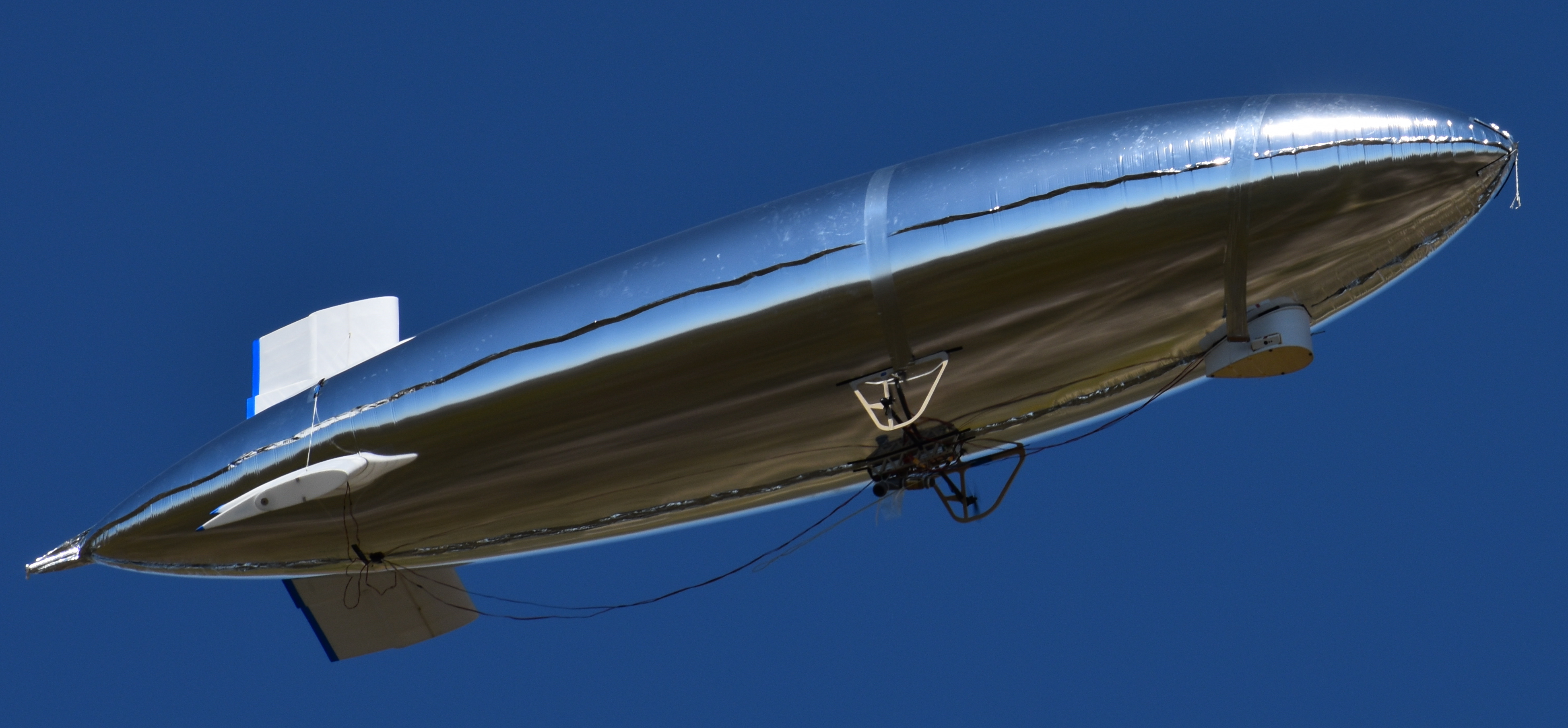
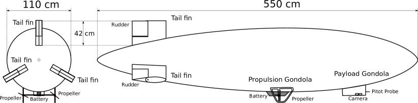
In cooperation with a commercial partner, German company “Windreiter” [28], we designed a , single hull prototype. It has a metal coated polymer film envelope with a mass of . To minimize drag, a configuration with 3 tail-fins was chosen. The propulsion gondola with batteries is located under the center of mass. Additionally, the airship is equipped with a forward mounted payload gondola, to physically distance sensors such as the magnetometer and pressure sensors from propulsion disturbances. The fins, rudders and gondolas are made from depron and plywood-depron sandwich. Each fin has a mass of approx . The total maximum payload capacity at sea level is (Fig. 1 top left, Fig. 2). A rope for ground handling has been attached to the nose of the vehicle.
3.1.2 Power Supply and Propulsion
The airship has been equipped with 2 Lithium Polymer batteries (), with the option of flying with a third battery for . Thrust is generated by 2 fixed, brush-less propellers in pull configuration, attached to the propulsion gondola. Power and propulsion have been designed w.r.t the air-frame with the goal of a top speed and sustained flight at for at least one hour.
3.1.3 Payload and Avionics
We equipped the airship with 2 Logitech Brio 4k USB webcams [16], one of which is front-facing for navigation while the other is pointing to starboard and 30 degrees down for subject observation. The main computer is an NVIDIA Jetson TX2 [20] on a AUVIDEA J-120 embedded board [2]. We utilize the TX2’s inbuilt 5 Ghz Wifi for inter-vehicle communication and communication with a ruggedized ground-station laptop. A Graupner HoTT transceiver [11] is used for remote flight control and long range telemetry operating on 2.4 GHz. The flight controller (FC) is an Openpilot Revolution STM32 based embedded board [13], equipped with IMU, 3 axis magnetometer and barometric static pressure sensor. Additionally, we equip a GPS receiver and a dynamic pressure based airspeed sensor consisting of a pitot tube and a differential pressure sensor. The TX2 is equipped with a SSD drive for on board data storage, sufficient for several hours of recordings.
3.2 Sensing and Computer Vision
The flight controller (FC) runs our ROS-enabled [24] version of Librepilot [14]. It includes an Extended Kalman Filter (EKF) for state estimation which fuses GPS, IMU, barometer and magnetometer for self-pose estimate (position and orientation), which is made available to ROS running on the TX2 main computer. We use our own distributed cooperative Bayesian foveated visual tracker [22] across one or multiple vehicles to improve the self pose estimate and track a motion capture (MoCap) subject, i.e. an animal on the ground. For visual detection in the relevant field of view (fov), our approach uses a convolutional single shot multibox detector (SSD) [15] running on the TX2.
3.3 Autonomous Control
All flight controls, i.e. all 3 rudders and the 2 main thrusters are directly controlled by the FC. A cascaded PID controller is implemented on the FC, which allows basic low level control, i.e. flying at a controlled airspeed and climb/sink rate on a straight or curved trajectory with controlled rotational rate. Furthermore, it is capable of position hold and waypoint navigation from our previous work [23]. This low-level controller is also used to enforce a “sky-box”, a geo-fenced area in which more sophisticated autonomous vision based navigation is permitted. This ensures no ground collisions or fly-away conditions are encountered, even if there is a failure in the high level control. Within the sky-box, when in autonomous mode, a Model Predictive Controller (MPC) [21] estimates the wind vector based on the airship’s groundspeed, dynamic pressure (i.e. airspeed), rotation rate and estimated angle of attack. The MPC knows the camera orientation on the airship. It calculates the optimal trajectory to keep the subject, which is tracked as described in Subsec. 3.2, centered in the camera field of view, while maintaining equal angular separation w.r.t. the subject between all vehicles in the formation. For this, optimal trajectories for all vehicles are calculated. The MPC takes collision avoidance constraints into account for both moving vehicles, the subject and known static obstacles. It avoids direct overflight of the MoCap subject for safety reasons. In the absence of obstacles and if winds are steady, the resulting trajectories resemble circular orbits around the subject, which are offset to one side based on the subjects velocity and/or wind [21]. In strong winds, different solutions are possible. A single airship can “hover” with its nose in the wind and/or fly parallel to a fast moving subject. Manual override via the remote control transmitter is always possible for safety reasons.
3.4 Simulation
We implemented an aerodynamic physics simulation of airship formations based on our previous work of simulation of non-rigid airships in turbulent wind [23] using ROS and Gazebo [9]. This includes hardware in the loop simulation, in which the low level flight control algorithms are running on a physical or software emulated FC in real-time. Since our formations are subject-centered, we include a simulated subject, which the SSD detector can detect in simulated camera images as presented in our simulation of MoCap using a formation of drones [22] and also for our MPC evaluation [21]. This allows for real-time simulation of all components under diverse conditions, including different wind and turbulence regimes, as well as the loop-closure between perception, sensor fusion and formation control relative to the tracked subject. All our control and simulation code is available open source for ease of reproduction and the benefit of the community [26].
4 Field Experiments, Practical Considerations and Results
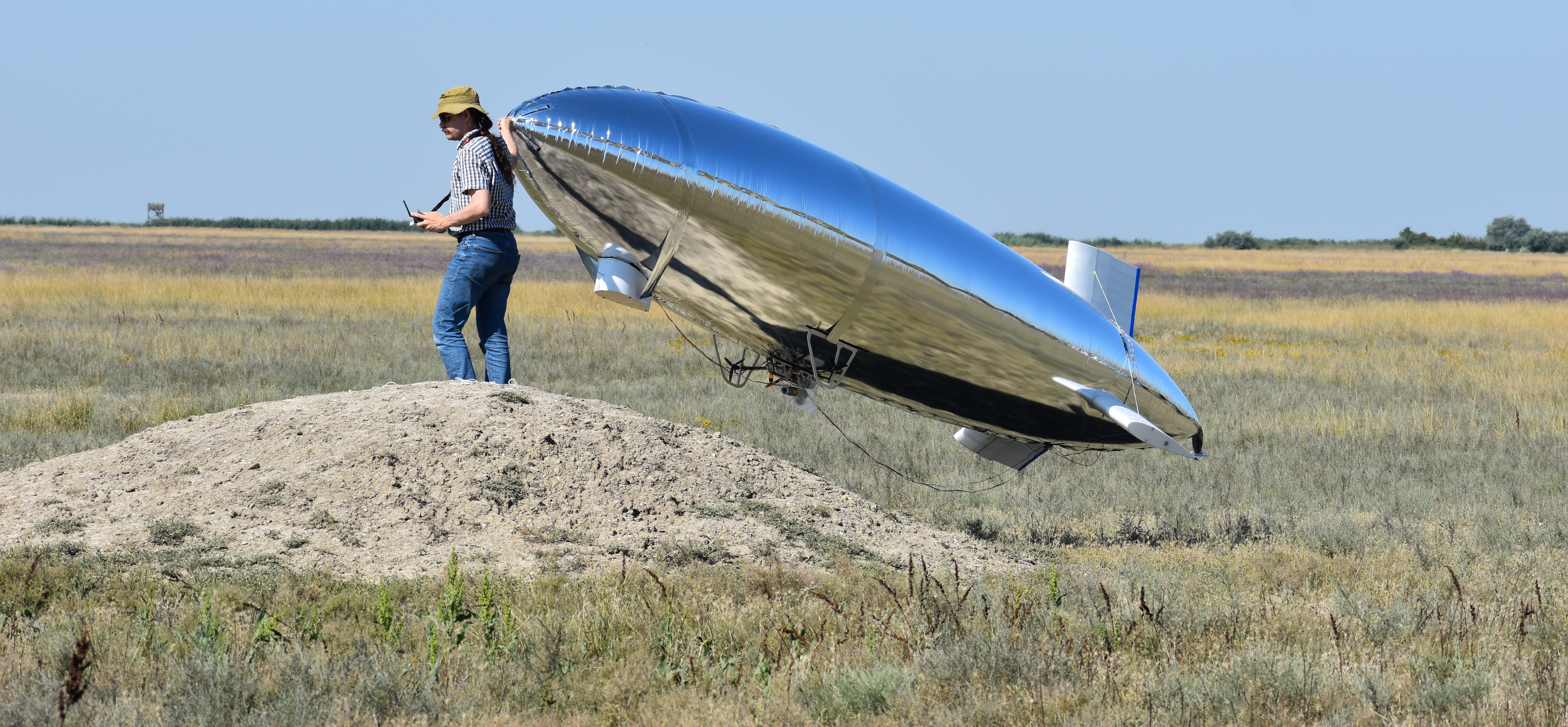
In August 2023, we conducted field experiments at the Hortobágy National Park in Hungary, which is an UNESCO world heritage property [27]. Our intent was to develop procedures and to assess the efficacy of airship and airship formations for motion capture and behavioral study of wild horses, particularly Przewalski’s horses (Equus ferus przewalskii). We used manually annotated aerial drone footage from the same herd of Przewalski’s taken the previous year to train our SSD detector network, in order to reliably detect these horses in aerial video frames. We brought the previously un-flown airship prototype (Subsec. 3.1) to the site in an off-road vehicle, along with two helium lift-gas cylinders (sufficient for ). The airship was assembled on-site. Although the use of a gazebo (tent) was considered, we opted instead for an empty farm-shed which was available on site to assemble and fill the airship. To protect the sensitive hull from dirt, a tarp was placed on the ground. A net over the hull was used to prevent the hull from rising until attachments, batteries and sufficient ballast could be equipped. A pressure reducer valve and a hose were used to fill the airship with helium. Metal screws in a plastic bag were attached to the main gondola as ballast, to trim the airship approx. heavier than air. Bringing the airship to the takeoff location was challenging due to gusty winds. It was not possible to maintain handling control over the airship using the gondola as a holding point due to excessive lateral wind forces. Handling became manageable using a rope attached to the nose. Takeoff and landing were performed by releasing and catching the airship by hand on the nose and front gondola. This was done on a small hill to increase ground clearance (Fig. 1 top right).
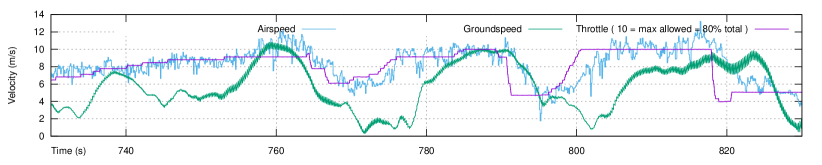
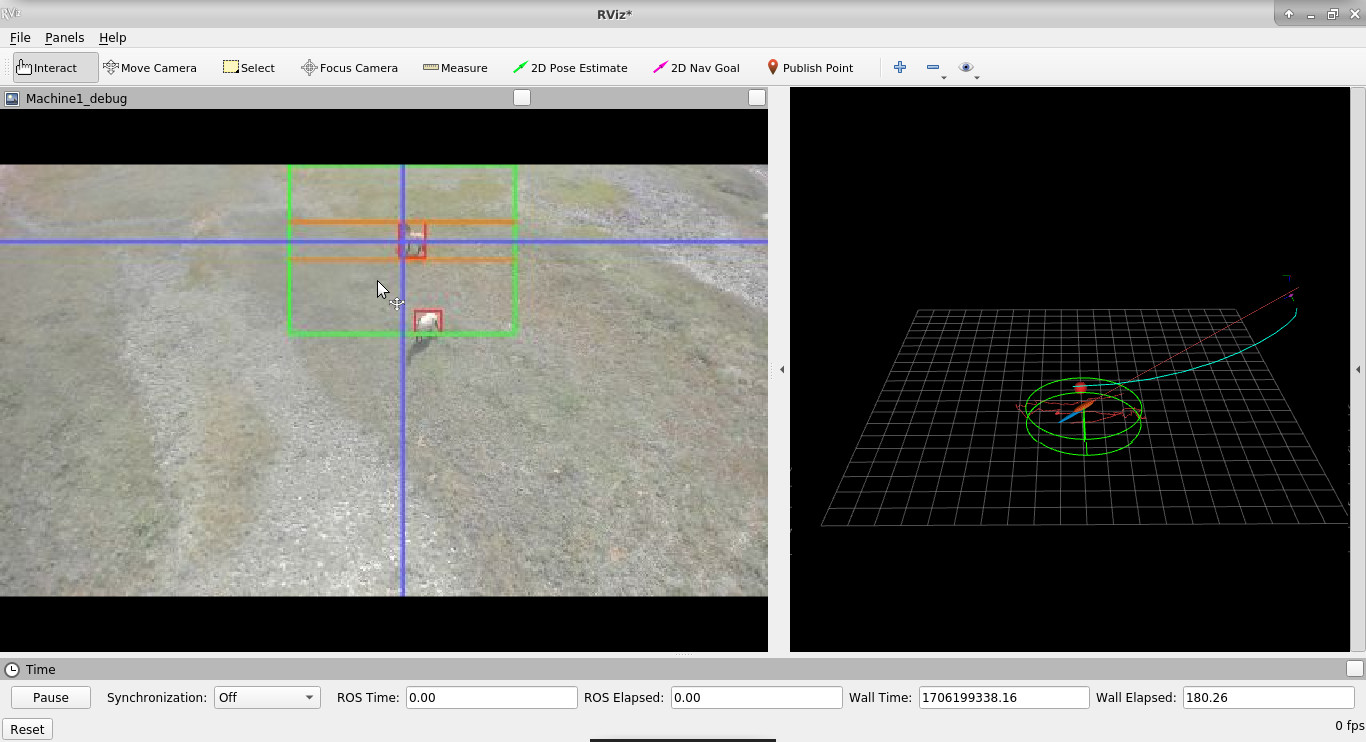
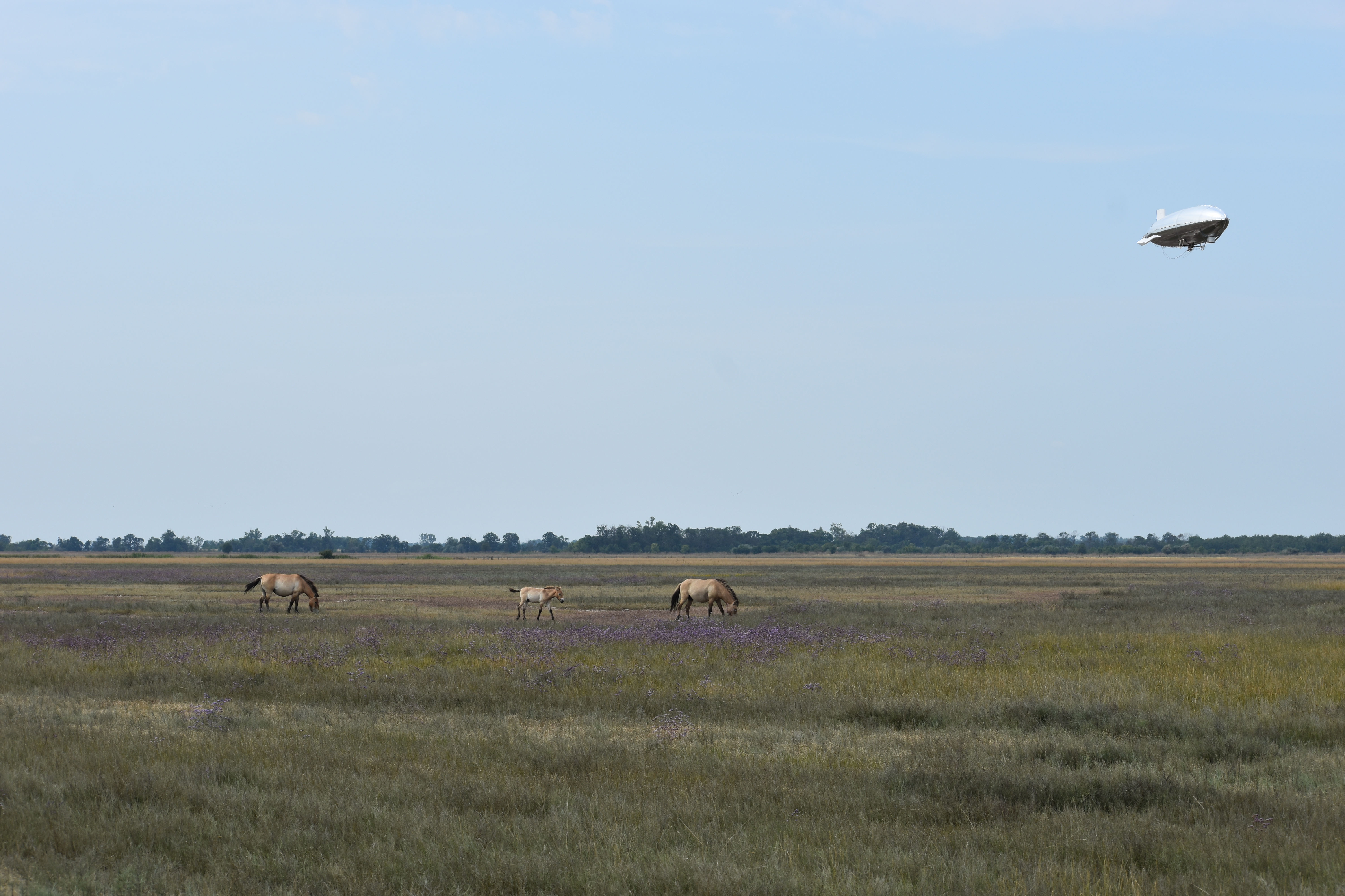
The vehicle maiden flight and initial tuning of the FC control coefficients were all conducted in situ. For safety reasons, the maximum throttle of the propellers was limited to , at which an airspeed of was achieved (Fig. 3). We measured a peak current of at sustained throttle in flight with a battery voltage of resulting in a maximum sustained power consumption of . Power consumption at throttle (half the allowed) was or at approx . We did not measure engine RPM. The expected flight endurance is reciprocal with electric current and can be calculated based on our battery capacity. Current and power are approximately proportional to the square of both the throttle setting and measured airspeed. Over several test-flights the various components were evaluated, including the formation controller using a 1-airship formation around a simulated stationary subject. It was determined that a minimum airspeed of was necessary to maintain sufficient vertical control authority in the presence of both strong thermals and micro bursts. Once the control accuracy was sufficient, the vehicle was flown manually into the vicinity of wild horses. The subject tracking and formation control was then activated in flight for an autonomous formation consisting of 1 airship and one subject horse. The initial acquisition of the subject in the camera image was challenging, since the camera was mounted sideways and has a limited field of view. It was difficult for the pilot to estimate the relative position of the airship in the air and the horses on the ground, especially w.r.t. relative distance. We later added a forward facing navigation camera to the gondola to address this problem. Both cameras can be monitored from the ground in real time. The formation was monitored with a ruggedized ground-station laptop, connected to the airship via Wifi. We achieved a practical Wifi range of approximately , which was a limiting factor but sufficient for our experiment. The operator could see a low-res visualization of the tracked subject, as seen by the on-board camera, on the laptop screen. We used the “rviz” ROS tool with an interactive camera plugin to point and click on the correct horse to track, which re-initialized the tracker with the projected camera coordinate. This was sufficient to initialize the formation control once the animal was in sight. A 3D-visualization showed the airships relative to the subject, along with the estimated position uncertainty (Fig. 1 bottom left). We collected video data of the horses with the autonomous airship in very challenging conditions with approx winds (Fig. 1 bottom right). Video and telemetry data of the flight were stored on the on-board SSD, both in form of compressed raw-video, radio-telemetry log files and ROS-bag-files. The used video storage format was mjpeg compressed raw video data as it came from the camera, enriched with microsecond accurate frame timing information. Telemetry was stored as a telemetry stream-dump with timing information, allowing replay and analysis in the Librepilot GCS software. Recorded ROS data consisted of crucial airship-state information including position, velocity, IMU data, airspeed as well as remote control inputs and setpoints at a rate of . ROS data also included low resolution video frames with annotations for debugging.
4.1 Discussion
The airship prototype exceeded our expectations. We went from maiden flight to successful autonomous flight tracking horses within only 4 days. The experiments showed that a vehicle with sufficient maximum airspeed and endurance has no problems tackling challenging wind conditions. Based on measured airspeed and power consumption, the calculated endurance of our airship at would be which is technically below the targeted . However, we attribute a large part of the high power consumption to drag caused by a foil-belt used for payload-gondola attachment, which started twisting and fluttering at high airspeeds. We flew with approximately of ballast, which could be partially replaced by another battery resulting in a endurance increase. Unlike multi-copters, adding more batteries to airships does not result in higher power consumption. This indicates that minor modification to the existing design would result in both higher flight speeds and an increased endurance, meeting our design goals. The ultra-light metal-coated polymer hull is fragile in ground handling and can easily be scratched, punctured or otherwise damaged. We also found out that touching the hull with sweaty hands causes corrosion and discoloration of the metal coating. A single hull vehicle also does not allow for dynamic pressure compensation without adding lift-gas. A double hull, although more limiting on payload, would be better suited in the long term, and allow easy installation of an air filled ballonet. Ground handling was also the limiting factor w.r.t. encountered wind speeds and gusts, since bringing the airship into a hangar, barn or shelter without colliding is very hard when there is lateral wind. During our experiments, ground handling mishaps were the only causes of damage to the vehicle, especially cracks in the depron material, which could be repaired in situ. Small punctures in the hull, caused by thorny vegetation, were easily fixed with patches of sticky tape, without noticeable loss of lift gas. Thermals and downdrafts were initially concerning, but could easily be overcome by ensuring the airship always maintained sufficient airspeed, i.e. vertical control authority. The system as a whole showed that airships are a feasible and convenient tool for autonomous animal observation and research, matching and - in the aspect of endurance - easily exceeding the abilities of drones. The perceived propulsion noise of the airship was also significantly lower than noise of a drone of comparable payload capacity. According to assessments by wildlife researchers observing our experiments, the presence of the airships did not disturb the horses.
5 Conclusions
We developed a system that allows for a formation of airships to autonomously follow and record horses from an aerial view, enabling unmatched research opportunities such as motion capture and behavior analysis. We showed that using airships for such studies in situ and in the wild is feasible. At a minimum a large tent or similar shelter is needed to fill and fully assemble airships and/or keep them out of the elements between experiments. This overhead is not unreasonable compared to other aerial vehicles, and we determined the benefits outweigh the inconveniences. Takeoff and handling in the air are not harder than other drones, and the data collected is of equal quality or superior. The main benefit of airships is the long flight time on the order of magnitude of hours, which allow for extended studies, impossible with multi-rotor drones. Control of airships, although more challenging than multi-copters capable of omni-directional movement can be solved with more sophisticated models and control methods, as we have shown. Our work is based on both open and proprietary hardware designs which are commercially available as well as publicly available open source projects. To foster lighter than air research and use of airships especially for wildlife research, we have shared all our simulation and control code, developed in previous works [22, 23, 21], for the benefit of the community111https://github.com/robot-perception-group/Airship-MPC.
References
- [1] Adams, K., Broad, A., Ruiz-García, D., Davis, A.R.: Continuous wildlife monitoring using blimps as an aerial platform: a case study observing marine megafauna. Australian Zoologist 40(3), 407–415 (05 2020). https://doi.org/10.7882/AZ.2020.004
- [2] Auvidea: Data sheet: J120 carrier board. http://web.archive.org/web/20240125100516/https://auvidea.eu/download/manual/J120/J120_technical_reference_1.6.pdf (2024)
- [3] Bauersfeld, L., Scaramuzza, D.: Range, endurance, and optimal speed estimates for multicopters. IEEE Robotics and Automation Letters 7(2), 2953–2960 (2022). https://doi.org/10.1109/LRA.2022.3145063
- [4] Bennitt, E., Bartlam-Brooks, H.L.A., Hubel, T.Y., Wilson, A.M.: Terrestrial mammalian wildlife responses to unmanned aerial systems approaches. Scientific Reports 9(1), 2142 (Feb 2019). https://doi.org/10.1038/s41598-019-38610-x
- [5] Bhat, S.S., Anavatti, S.G., Garratt, M., Ravi, S.: Review of autonomous outdoor blimps and their applications. Drone Systems and Applications 12, 1–21 (2024). https://doi.org/10.1139/dsa-2023-0052
- [6] Chabot, D., Bird, D.M.: Wildlife research and management methods in the 21st century: Where do unmanned aircraft fit in? Journal of Unmanned Vehicle Systems Virtual Issue 01(01), 137–155 (2016). https://doi.org/10.1139/juvs-2015-0021
- [7] Cross, W.: Zeppelins of World War I. Barnes & Noble Books (1993)
- [8] Frobenius, L.: Die Möglichkeit einer Deutsch-Inner-Afrikanischen Luftflottenstation : (erster Bericht über die Studienergebnisse der Motorkommission der "Deutschen Inner-Afrikanischen Forschungs-Expedition" vorgetragen im Reichstage am 5. Februar 1913). Verlagsbuchhandlung Wilhelm Süsserott, Berlin (1913), http://publikationen.ub.uni-frankfurt.de/frontdoor/index/index/docId/59274
- [9] Furrer, F., Burri, M., Achtelik, M., Siegwart, R.: Robot Operating System (ROS): The Complete Reference (Volume 1), chap. RotorS—A Modular Gazebo MAV Simulator Framework, pp. 595–625. Springer International Publishing, Cham (2016). https://doi.org/10.1007/978-3-319-26054-9_23
- [10] Gerke, M., Borgolte, U., Masár, I., Jelenciak, F., Bahnik, P., Al-Rashedi, N.: Lighter-than-air uavs for surveillance and environmental monitoring. In: Aschenbruck, N., Martini, P., Meier, M., Tölle, J. (eds.) Future Security. pp. 480–483. Springer Berlin Heidelberg, Berlin, Heidelberg (2012). https://doi.org/10.1007/978-3-642-33161-9_69
- [11] Graupner: Data sheet: Gr-16. https://web.archive.org/web/20240125100845/https://controlhobbies.s3-us-west-1.amazonaws.com/Manuals/GR_12_16_24_32_Receiver_Manual_EN.pdf (2024)
- [12] Ilcev, S.D., Skoryk, I.: Automatic landing of animal tracking lighter-than-air systems (ltas) on the recharging platform. In: 2014 24th International Crimean Conference Microwave & Telecommunication Technology. pp. 275–277 (2014). https://doi.org/10.1109/CRMICO.2014.6959391
- [13] LibrePilot: Archived web page: Openpilot revolution. http://tinyurl.com/ARCHIVEDOPREVO (2024)
- [14] LibrePilot, Robot Perception Group: Git repository: Ros enabled librepilot source code for airships. https://github.com/robot-perception-group/LibrePilot/tree/airship_control_noetic (2024)
- [15] Liu, W., Anguelov, D., Erhan, D., Szegedy, C., Reed, S., Fu, C.Y., Berg, A.C.: Ssd: Single shot multibox detector. In: Leibe, B., Matas, J., Sebe, N., Welling, M. (eds.) Computer Vision – ECCV 2016. pp. 21–37. Springer International Publishing, Cham (2016). https://doi.org/10.1007/978-3-319-46448-0_2
- [16] Logitech: Data sheet: Brio web cam. https://web.archive.org/web/20240125095001/https://www.logitech.com/content/dam/logitech/en_us/video-collaboration/pdf/brio-datasheet.pdf (2024)
- [17] Mazumdar, S.: Drone Applications in Wildlife Research—A Synoptic Review, pp. 237–257. Springer Nature Singapore, Singapore (2022). https://doi.org/10.1007/978-981-19-2083-7_14
- [18] Mo, M., Bonatakis, K.: Approaching wildlife with drones: using scientific literature to identify factors to consider for minimising disturbance. Australian Zoologist 42(1), 1–29 (07 2021). https://doi.org/10.7882/AZ.2021.015
- [19] Nelson, S.B.: Airships in the arctic. ARCTIC 46(3), 278–283 (1993)
- [20] NVIDIA: Data sheet: Jetson tx2. http://tinyurl.com/ARCHIVEDNVTX2DS (2024)
- [21] Price, E., Black, M.J., Ahmad, A.: Viewpoint-driven formation control of airships for cooperative target tracking. IEEE Robotics and Automation Letters 8(6), 3653–3660 (June 2023). https://doi.org/10.1109/LRA.2023.3264727
- [22] Price, E., Lawless, G., Ludwig, R., Martinovic, I., Bülthoff, H.H., Black, M.J., Ahmad, A.: Deep neural network-based cooperative visual tracking through multiple micro aerial vehicles. IEEE Robotics and Automation Letters 3(4), 3193–3200 (Oct 2018). https://doi.org/10.1109/LRA.2018.2850224
- [23] Price, E., Liu, Y.T., Black, M.J., Ahmad, A.: Simulation and control of deformable autonomous airships in turbulent wind. In: Ang Jr, M.H., Asama, H., Lin, W., Foong, S. (eds.) Intelligent Autonomous Systems 16. pp. 608–626. Springer International Publishing, Cham (2022). https://doi.org/10.1007/978-3-030-95892-3_46
- [24] Quigley, M., Conley, K., Gerkey, B., Faust, J., Foote, T., Leibs, J., Wheeler, R., Ng, A.Y.: Ros: an open-source robot operating system. In: ICRA workshop on open source software. vol. 3, p. 5. Kobe (2009)
- [25] Rinker, H.B., Lowman, M.D., Moffett, M.W.: Africa from the treetops. The American Biology Teacher 57(7), 393–401 (1995), http://www.jstor.org/stable/4450028
- [26] Robot Perception Group: Git repository: Simulation and control demo code. https://github.com/robot-perception-group/Airship-MPC (2024)
- [27] UNESCO: Archived web page: Hortobágy national park. https://web.archive.org/web/20240125130845/https://whc.unesco.org/en/list/474 (2024)
- [28] Windreiter: Archived web page: Windreiter. https://web.archive.org/web/20240125103634/https://www.windreiter.com/ (2024)