Data Science for Geographic Information Systems
Abstract
1
The integration of data science into Geographic Information Systems (GIS) has facilitated the evolution of these tools into complete spatial analysis platforms. The adoption of machine learning and big data techniques has equipped these platforms with the capacity to handle larger amounts of increasingly complex data, transcending the limitations of more traditional approaches. This work traces the historical and technical evolution of data science and GIS as fields of study, highlighting the critical points of convergence between domains, and underlining the many sectors that rely on this integration. A GIS application is presented as a case study in the disaster management sector where we utilize aerial data from Tróia, Portugal, to emphasize the process of insight extraction from raw data. We conclude by outlining prospects for future research in integration of these fields in general, and the developed application in particular.
2 Keywords:
geographical information systems, remote sensing, big data, machine learning, data science
3 Introduction
In the era of data-driven decision making, the fusion of two prevalent disciplines, Data Science and Geographic Information Systems (GIS), stands at the forefront of transformative innovations. Data Science, with its emphasis on extracting meaningful insights from vast datasets, and GIS, traditionally employed in mapping and spatial analysis, are converging to create a synergistic relation. This integration is proving to be more than a technological evolution; it is a paradigm shift in our approach to understanding and interpreting spatial information.
In the sections that follow, we will discuss the historical evolution of GIS and Data Science, dissect the key components defining their intersection, and explore real-world applications that highlight the potential of this integration. This paper aims to emphasize the evolving role that Spatial Data Science plays in reshaping our understanding of spatial decision-making processes.
This work is divided into six sections as follows: Firstly, a historical record of the development of the fields of data science (Section 4) and of GISs (Section 5). Then, an overview of the convergence of the two fields (Section 6) followed by an illustration of the various applications in different areas of interest that hinge on this convergence (Section 7). Finally, we proceed with a small case study to illustrate the process of extracting insights from raw data (Section 8), and conclude with some final remarks on the work and prospects on the importance of this synergy for future work (Section 9).
4 Emergence of Data Science
Data science emerged as an interdisciplinary field during the second half of the 20th century in response to the escalating volume and complexity of data in the rapidly advancing digital age. It evolved as a convergence of computer science and statistics, applying statistical techniques and using computational tools to extract valuable insights and knowledge from datasets.
The evolution of data science can be traced through transformative milestones. In its early stages, as machine learning gained traction (Flach, 2012; Borges, 1989) and more sophisticated statistical methods were developed (Kotz and Johnson, 2012; Freedman, 2009), relational databases and data warehousing technologies became crucial for managing and organizing data (Chaudhuri and Dayal, 1997).
With the concept of data warehousing gaining prominence, emphasizing the need for centralized repositories to store integrated historical data (Gardner, 1998; Kimball, 1996), advances in data mining (Fayyad et al., 1996) leveraged these emerging technologies as the backbone for storing and managing larger datasets (Chaudhuri and Dayal, 1997).
Eventually, the emergence of big data (Mayer-Schönberger and Cukier, 2013), accompanied by the widespread adoption of open-source tool ecosystems, such as R and Python (Ihaka and Gentleman, 1996; McKinney, 2012), reached a critical point. Later data science would evolve into a recognized, specialized, and interdisciplinary field (Dhar, 2013), witnessing the big resurgence of deep learning and its integration across industries (Goodfellow et al., 2016), significantly impacting business decision-making (Schoenherr and Speier-Pero, 2015; Van Der Aalst and van der Aalst, 2016).
Recently, there has been an increasing focus on ethical considerations, responsible AI practices, and fairness in data science applications (Diakopoulos, 2016; Mittelstadt et al., 2016). Regardless, data science remains a vital component of decision-making processes in most industries, reflecting the dynamic nature of its continuous development over time.
5 Evolution of Geographic Information Systems
A GIS is a system designed to capture, store, analyze, manage, and present spatial data. GIS allows users to visualize, interpret, and understand data in a spatial context (Longley et al., 2015; Burrough et al., 2015). Since their inception in the early 1960s, these systems have undergone a notable evolution. Originally conceived simply as computerized tools for land resource management, GIS has progressed through various stages of development.
During its initial stages, GIS primarily concentrated on the digitization of maps and the conceptualization of spatial databases. The foundational work carried out by Roger Tomlinson (Tomlinson, 1974) set the stage for the development of the first computerized GIS. With advances in computer technology, the 1970s and early 1980s witnessed the commercialization of GIS software, with significant contributions from companies such as the Environmental Systems Research Institute (ESRI).
During the following decades, the incorporation of remote sensing data—satellite imagery in particular—was a pivotal development for enhancing the capabilities of GIS (Merchant, 2000). Standardization efforts, led by the Open Geospatial Consortium (OGC), aimed to establish interoperability among GIS platforms. Furthermore, the 1990s also included the first definitions of GIS as a scientific area of development—GIScience (Rocha and Abrantes, 2019).
During the early 2000s, GIS underwent a transition to the web, facilitating greater accessibility to spatial data (Chang, 2008). Subsequently, the rise of cloud-based GIS platforms and the popularity of web mapping applications (Peterson, 2005), such as Google Maps, significantly contributed to the widespread recognition of GIS.
The 2010s and beyond witnessed the advent of mobile GIS and the growth of location-based services (Hussein et al., 2011), harnessing the widespread use of smartphones for real-time data collection and field mapping (Khan et al., 2012). During this time, there was also a considerable adoption of big data methods and advanced spatial analytics within GIS applications (Goodchild, 2016).
6 Key Components of Data Science in GIS
This section explores and covers key aspects of the synergy between GIS and data science. It begins with spatial data handling and addresses techniques and challenges in preprocessing and analysis ( Subsection 6.1). Next, the impact of Machine Learning (ML) in spatial analysis is explored ( Subsection 6.2), followed by several insights on the use of Big Data technologies in the context of GIS and the importance of scalable solutions ( Subsection 6.3). Finally, the section concludes with the importance of effective data communication in GIS, offering a brief explanation on spatial data representation and interpretation ( Subsection 6.4).
6.1 Spatial Data Handling
Spatial data handling in GIS involves the application of data science techniques to efficiently manage and process geographical information. Techniques, including spatial indexing, geocoding, and spatial querying, play important roles in optimizing data retrieval and analysis. Spatial Indexing involves organizing data to facilitate efficient spatial queries, optimizing data retrieval processes. Geocoding converts places of interest into geographic coordinates, a fundamental step for mapping and essential for spatial analysis and data integration. Lastly, Spatial Querying allows for the retrieval of information based on spatial relations or conditions, offering valuable insights from spatial data crucial for decision-making processes. This field is deemed so crucial that it is often considered a subset of data science itself—spatial data science (Garrard, 2016; Rey et al., 2023; Comber and Brunsdon, 2020).
Managing spatial datasets poses significant challenges, encompassing concerns related to data heterogeneity, resolution discrepancies, and the necessity for constant updates. Addressing these challenges involves placing a strong emphasis on data cleaning and preprocessing to uphold accuracy in subsequent spatial analyses. Importantly, these challenges give rise to opportunities for innovation. This includes the development of resilient data integration frameworks and the utilization of ML for the automated cleaning of spatial data, topics that will be further explored in subsequent sections.
6.2 Machine Learning
ML has emerged as a game-changing tool within the domain of GIS, facilitating the extraction of valuable insights from spatial datasets and augmenting traditional spatial analysis (Choudhury and Um, 2023; Casali et al., 2022). ML algorithms brought a data-driven and adaptive approach to spatial problem-solving, allowing GIS professionals to uncover more intricate patterns, make more accurate predictions, and automate once complex and time consuming tasks.
Feature recognition and extraction are ML techniques that allow automating the identification of spatial patterns and objects. This capability is particularly evident in applications like image classification (Sulemane et al., 2022; Lim et al., 2019), where ML algorithms discern and categorize features within satellite or aerial imagery, contributing to tasks such as land-use classification and environmental monitoring.
6.3 Big Data
Traditional GIS methodologies, designed for smaller datasets, struggle with the scale and variety of data generated nowadays. Large-scale spatial datasets, stemming from sources such as satellite imagery, sensor networks, and social media, require innovative approaches to storage, processing, and analysis.
To address the challenges presented by large spatial datasets, GIS developers are increasingly embracing Big Data technologies and methodologies (Akhund, 2022; Lee and Kang, 2015; Li et al., 2016). This shift aims to establish scalable and distributed computing frameworks that efficiently process extensive amounts of spatial data. Two critical paradigms in this context are the parallelization of spatial data (Zhao et al., 2016; Werner, 2019) and the scalability of spatial systems (Jhummarwala et al., 2014; Neuman, 1994; Hawick et al., 2003).
Spatial data processing and analysis can be efficiently parallelized across a distributed environment, allowing for the execution of tasks that would be prohibitively time-consuming with traditional approaches, therefore enabling the extraction of more meaningful insights from massive datasets. These distributed solutions can also significantly contribute to the question of scalability, ensuring that GIS applications can handle expanding datasets without sacrificing performance.
The significance of scalable and efficient data processing in the context of Big Data and GIS cannot be overstated. As spatial datasets continue to grow, the ability to process information at scale becomes paramount for timely decision-making and insightful analysis. Scalable data processing not only addresses the challenges of handling large datasets more efficiently but also unlocks the potential for real-time (Sun and Li, 2016; Al-Sabhan et al., 2003) and near-real-time (Gamba and Casciati, 1998) spatial analytics, enabling a dynamic response to evolving spatial phenomena previously difficult to achieve (Zerger and Smith, 2003).
6.4 Data Visualization and Interpretation
Effective communication of spatial information is a key aspect of GIS, and data visualization is a powerful tool in achieving this goal (Longley et al., 2015). Data science and data visualization techniques are employed to create visually appealing and informative representations, allowing the transformation of large and complex spatial datasets into comprehensible and insightful depictions (Ki, 2018).
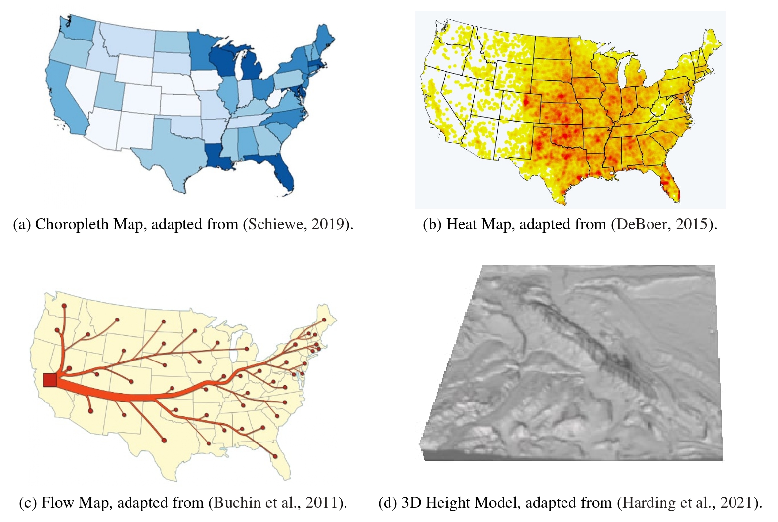
Well-designed maps and graphics enhance the interpretability of spatial information (Slocum et al., 2022), enabling stakeholders to make more informed decisions. GIS enables the creation of a plethora of spatial data representations—whether in 2D, 3D, or even VR—facilitating the analysis and conveyance of complex spatial patterns and trends in an accessible manner (Mitchell, 1999; Mitchel et al., 2005).
Numerous methods exist for representing spatial data. Some of the most important are illustrated in Figure 1.
 |
7 Applications
The integration of GIS and data science has spurred transformative applications across various domains. This section will explore some key areas where the synergy of GIS and data science has been notable, highlighting the versatility and impact of these fields. We start by looking into urban and infrastructure planning (Subsection 7.1) and examining the far-reaching implications on environmental analysis and conservation efforts (Subsection 7.2). Moving forward, we explore the impact on public health and safety (Subsection 7.3). Finally, we discuss several applications within the agricultural domain (Subsection 7.4). This exploration will underscore the multifaceted contributions of GIS and data science in addressing complex challenges across various sectors.
7.1 Urban and Infrastructure Planning
By analyzing large datasets, urban planners can gain valuable insights into population trends, traffic patterns (Yang et al., 2019), and public infrastructure usage (Mohammadi and Al-Fuqaha, 2018). This information aids in designing efficient transportation systems (Torre-Bastida et al., 2018) and optimizing current city layouts and future developments (Hao et al., 2015). Furthermore, machine learning algorithms can be employed to predict urban growth, enabling proactive planning to accommodate increasing population demands (Chaturvedi and de Vries, 2021). Additionally, GIS-based data science has the potential to help in assessing the impact of urban projects on the environment and social dynamics (Kitchin, 2016).
7.2 Environmental Analysis and Conservation
Remote sensing data, satellite imagery, and ground-based sensor data can be integrated to monitor dynamic changes in ecosystems (Hansen and Loveland, 2012), enabling the identification of deforestation and unexpected alterations in habitats (Pettorelli et al., 2014; Sexton et al., 2013). Furthermore, advanced analytics facilitate the discernment of environmental patterns, allowing conservationists to make well-informed decisions regarding conservation efforts (Horning et al., 2010). Finally, using historical data, machine learning models can help predict the occurrence and impact of natural disasters (Linardos et al., 2022), including wildfires (Jain et al., 2020; Oliveira et al., 2023; Fachada, 2022), earthquakes (Galkina and Grafeeva, 2019), or floods (Mosavi et al., 2018). This predictive capability enhances preparedness and response strategies for more effective disaster management.
7.3 Public Health and Safety
In the domain of public health, integrated demographic information, disease prevalence, and environmental factors data can be used to identify potential health risks and patterns (Kubben et al., 2019). Maps can be employed to visualize the spread of diseases, plan healthcare infrastructure, and optimize resource allocation during health emergencies (Kamel Boulos and Geraghty, 2020). Predictive modeling aids in forecasting disease outbreaks, enabling authorities to implement efficient interventions (Pullan et al., 2011). Additionally, spatial data science can contribute to identify environmental factors affecting public health, supporting initiatives for cleaner and healthier living environments (Maantay and McLafferty, 2011).
7.4 Agricultural Optimization
Data science applications in GIS can significantly enhance agricultural practices by providing insights into crop health, soil conditions, and weather patterns (Wardlow et al., 2007; Mitran et al., 2021). Monitoring crop growth, detecting diseases, and optimizing irrigation become feasible through the integration of satellite imagery and terrain sensor data, coupled with predictive algorithms (Thenkabail et al., 2009). Furthermore, these applications can predict crop yields, identify optimal planting times, determine suitable crop types, and recommend maintenance methods (He et al., 2017; Priya and Shibasaki, 2001; dos Santos et al., 2023).
 |
8 Case Study
In this section, we will present a case study integrating data science and GIS, describing the data processing and analysis workflow, while highlighting the transformation of raw data into knowledge and insight—from dataset exploration to the final results.
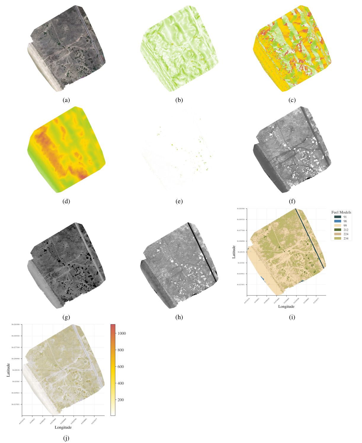
For the purpose of this case study, we use two datasets: 1) aerial imagery encompassing red, blue, green, near-infrared (NIR), and red-edge bands; and, 2) a Digital Elevation Model (DEM). The focus of this study is a small land patch situated in Tróia, Portugal, an RGB representation of which is shown in Figure 2a. All data was collected in 2022.
The initial step involves extracting topographical data from the area using the DEM. This crucial step yields both the Digital Terrain Model (DTM) and the Digital Surface Model (DSM), providing elevation information for each point at ground level and the at maximum height. Some of the most important topographical features to extract are the slope, the aspect, and the elevation of the area. Additionally, the DEM enables us to determine vegetation height (as well as the height of other objects) by calculating the difference between the DTM and the DSM. Figures 2b, 2c, 2d and 2e exhibit the data extracted from the DEM dataset.
Subsequently, leveraging the multispectral aerial dataset, we can enhance various objects through the application of multispectral indices. Specifically, we employ the Normalized Difference Vegetation Index (NDVI) for vegetation, the Normalized Difference Water Index (NDWI) for water features, and the Green Atmospherically Resistant Vegetation Index (GARI) for man-made structures, as shown in Figures 2f, 2g and 2h. These indices were selected empirically, tailored specifically for the nuances of this case study.
Finally, synthesizing all this knowledge, we can create a fuel map of the area, which, in turn, can serve diverse purposes, such as wildfire prevention measures through simulated prediction (Fachada, 2022). This could, for example, allow to the computation of a Burning Index (BI) map, serving as a danger indicator to assist authorities in making better decisions regarding wildfire combat and terrain maintenance. Figures 2i and 2j highlight the fuel and BI result for the area analyzed in this case study.
9 Conclusions
The integration of data science and GIS has ushered in a new era of spatial analysis, offering unprecedented opportunities for understanding and interpreting spatial data.
This work has provided an overview of the evolution of both data science and GIS, tracing their development from their early beginnings to their current state. Furthermore, we have highlighted the key components defining the intersection of these fields and have explored a range of applications demonstrating the versatility and impact of GIS and data science integration.
The presented case study exemplifies the practical implementation of data science techniques in GIS, showcasing how raw data can be transformed into actionable insights. Furthermore, we illustrated the application of this knowledge in creating fuel maps and predicting burning indices for wildfire prevention measures.
Looking ahead, the prospects for further research and development in this field are promising. As technologies continue to advance, there is an opportunity to explore new methodologies and algorithms for enhanced spatial analysis and decision support systems. Furthermore, the integration of emerging technologies such as artificial intelligence, remote sensing, and Internet of Things (IoT) devices holds immense potential for addressing pressing global challenges, including climate change, natural disasters, and sustainable development.
Conflict of Interest Statement
The authors declare that the research was conducted in the absence of any commercial or financial relationships that could be construed as a potential conflict of interest.
Author Contributions
Afonso Oliveira: Investigation, Methodology, Software, Writing - Original Draft. Nuno Fachada: Supervision, Writing - Review & Editing, Visualization. João P. Matos-Carvalho: Supervision, Writing - Review & Editing.
Funding
This work was financed by the Portuguese Agency FCT (Fundação para a Ciência e Tecnologia), in the framework of projects UIDB/00066/2020, UIDB/04111/2020 and CEECINST/00147/2018/CP1498/CT0015.
Data Availability Statement
Datasets are available on request. The raw data supporting the conclusions of this article will be made available by the authors, without undue reservation.
References
- Akhund (2022) [Dataset] Akhund, S. (2022). Analysis of spatial big data for geographical information systems. 10.13140/RG.2.2.20522.70080/2
- Al-Sabhan et al. (2003) Al-Sabhan, W., Mulligan, M., and Blackburn, G. A. (2003). A real-time hydrological model for flood prediction using gis and the www. Computers, Environment and Urban Systems 27, 9–32
- Borges (1989) Borges, L. R. (1989). Analysis of the wisconsin breast cancer dataset and machine learning for breast cancer detection. Group 1, 15–19
- Burrough et al. (2015) Burrough, P. A., McDonnell, R. A., and Lloyd, C. D. (2015). Principles of geographical information systems (Oxford University Press, USA)
- Casali et al. (2022) Casali, Y., Aydin, N. Y., and Comes, T. (2022). Machine learning for spatial analyses in urban areas: a scoping review. Sustainable Cities and Society 85, 104050
- Chang (2008) Chang, K.-T. (2008). Introduction to geographic information systems, vol. 4 (Mcgraw-hill Boston)
- Chaturvedi and de Vries (2021) Chaturvedi, V. and de Vries, W. T. (2021). Machine learning algorithms for urban land use planning: A review. Urban Science 5, 68
- Chaudhuri and Dayal (1997) Chaudhuri, S. and Dayal, U. (1997). Data warehousing and olap for decision support. In Proceedings of the 1997 ACM SIGMOD international conference on Management of Data. 507–508
- Choudhury and Um (2023) Choudhury, T. and Um, J.-S. (2023). Geospatial data analysis through artificial intelligence: editorial column. GeoJournal , 1–2
- Comber and Brunsdon (2020) Comber, L. and Brunsdon, C. (2020). Geographical data science and spatial data analysis: an introduction in R (Sage)
- Dhar (2013) Dhar, V. (2013). Data science and prediction. Communications of the ACM 56, 64–73
- Diakopoulos (2016) Diakopoulos, N. (2016). Accountability in algorithmic decision making. Communications of the ACM 59, 56–62
- dos Santos et al. (2023) dos Santos, R. P., Fachada, N., Beko, M., and Leithardt, V. R. (2023). A rapid review on the use of free and open source technologies and software applied to precision agriculture practices. Journal of Sensor and Actuator Networks 12, 28
- Fachada (2022) Fachada, N. (2022). A computational pipeline for modeling and predicting wildfire behavior. In Proceedings of the 7th International Conference on Complexity, Future Information Systems and Risk - COMPLEXIS. INSTICC (SciTePress), 79–84. 10.5220/0011073900003197
- Fayyad et al. (1996) Fayyad, U., Piatetsky-Shapiro, G., and Smyth, P. (1996). From data mining to knowledge discovery in databases. AI magazine 17, 37–37
- Fernandes and Loureiro (2022) Fernandes, P. and Loureiro, C. (2022). Modelos de combustível florestal para portugal - documento de referência, versão de 2021
- Flach (2012) Flach, P. (2012). Machine learning: the art and science of algorithms that make sense of data (Cambridge university press)
- Freedman (2009) Freedman, D. A. (2009). Statistical models: theory and practice (cambridge university press)
- Galkina and Grafeeva (2019) Galkina, A. and Grafeeva, N. (2019). Machine learning methods for earthquake prediction: A survey. In Proceedings of the Fourth Conference on Software Engineering and Information Management (SEIM-2019), Saint Petersburg, Russia. vol. 13, 25
- Gamba and Casciati (1998) Gamba, P. and Casciati, F. (1998). Gis and image understanding for near-real-time earthquake damage assessment. Photogrammetric engineering and remote sensing 64, 987–994
- Gardner (1998) Gardner, S. R. (1998). Building the data warehouse. Communications of the ACM 41, 52–60
- Garrard (2016) Garrard, C. (2016). Geoprocessing with python (Simon and Schuster)
- Goodchild (2016) Goodchild, M. F. (2016). Gis in the era of big data. Cybergeo: European journal of geography
- Goodfellow et al. (2016) [Dataset] Goodfellow, I., Bengio, Y., Courville, A., and Bengio, Y. (2016). Deep learning, volume 1
- Hansen and Loveland (2012) Hansen, M. C. and Loveland, T. R. (2012). A review of large area monitoring of land cover change using landsat data. Remote sensing of Environment 122, 66–74
- Hao et al. (2015) Hao, J., Zhu, J., and Zhong, R. (2015). The rise of big data on urban studies and planning practices in china: Review and open research issues. Journal of Urban Management 4, 92–124
- Hawick et al. (2003) Hawick, K. A., Coddington, P. D., and James, H. A. (2003). Distributed frameworks and parallel algorithms for processing large-scale geographic data. Parallel Computing 29, 1297–1333
- He et al. (2017) He, D., Wang, E., Wang, J., and Lilley, J. M. (2017). Genotype environment management interactions of canola across china: A simulation study. Agricultural and Forest Meteorology 247, 424–433
- Horning et al. (2010) Horning, N., Robinson, J. A., Sterling, E. J., and Turner, W. (2010). Remote sensing for ecology and conservation: a handbook of techniques (Oxford University Press)
- Hussein et al. (2011) Hussein, A. A., Eibrahim, E. H., and Asem, A. (2011). Mobile geographic information systems: a case study on mansoura university, egypt. International journal of computer science & information technology 3, 173
- Ihaka and Gentleman (1996) Ihaka, R. and Gentleman, R. (1996). R: A language for data analysis and graphics. journal of computational and graphical statistics 5: 299. doi: 10.2307/1390807
- Jain et al. (2020) Jain, P., Coogan, S. C., Subramanian, S. G., Crowley, M., Taylor, S., and Flannigan, M. D. (2020). A review of machine learning applications in wildfire science and management. Environmental Reviews 28, 478–505
- Jhummarwala et al. (2014) Jhummarwala, A., Potdar, M., and Chauhan, P. (2014). Parallel and distributed gis for processing geo-data: An overview. International Journal of Computer Applications 106, 9–16
- Kamel Boulos and Geraghty (2020) [Dataset] Kamel Boulos, M. N. and Geraghty, E. M. (2020). Geographical tracking and mapping of coronavirus disease covid-19/severe acute respiratory syndrome coronavirus 2 (sars-cov-2) epidemic and associated events around the world: how 21st century gis technologies are supporting the global fight against outbreaks and epidemics
- Khan et al. (2012) Khan, W. Z., Xiang, Y., Aalsalem, M. Y., and Arshad, Q. (2012). Mobile phone sensing systems: A survey. IEEE Communications Surveys & Tutorials 15, 402–427
- Ki (2018) Ki, J. (2018). Gis and big data visualization. In Geographic Information Systems and Science (IntechOpen)
- Kimball (1996) Kimball, R. (1996). The data warehouse toolkit: practical techniques for building dimensional data warehouses (John Wiley & Sons, Inc.)
- Kitchin (2016) Kitchin, R. (2016). The ethics of smart cities and urban science. Philosophical transactions of the royal society A: Mathematical, physical and engineering sciences 374, 20160115
- Kotz and Johnson (2012) Kotz, S. and Johnson, N. L. (2012). Breakthroughs in Statistics: Foundations and basic theory (Springer Science & Business Media)
- Kubben et al. (2019) Kubben, P., Dumontier, M., and Dekker, A. (2019). Fundamentals of clinical data science
- Lee and Kang (2015) Lee, J.-G. and Kang, M. (2015). Geospatial big data: challenges and opportunities. Big Data Research 2, 74–81
- Li et al. (2016) Li, S., Dragicevic, S., Castro, F. A., Sester, M., Winter, S., Coltekin, A., et al. (2016). Geospatial big data handling theory and methods: A review and research challenges. ISPRS journal of Photogrammetry and Remote Sensing 115, 119–133
- Lim et al. (2019) Lim, J., Kim, K.-M., and Jin, R. (2019). Tree species classification using hyperion and sentinel-2 data with machine learning in south korea and china. ISPRS International Journal of Geo-Information 8, 150
- Linardos et al. (2022) Linardos, V., Drakaki, M., Tzionas, P., and Karnavas, Y. L. (2022). Machine learning in disaster management: recent developments in methods and applications. Machine Learning and Knowledge Extraction 4
- Longley et al. (2015) Longley, P. A., Goodchild, M. F., Maguire, D. J., and Rhind, D. W. (2015). Geographic information science and systems (John Wiley & Sons)
- Maantay and McLafferty (2011) Maantay, J. A. and McLafferty, S. (2011). Geospatial analysis of environmental health, vol. 4 (Springer Science & Business Media)
- Mayer-Schönberger and Cukier (2013) Mayer-Schönberger, V. and Cukier, K. (2013). Big data: A revolution that will transform how we live, work, and think (Houghton Mifflin Harcourt)
- McKinney (2012) McKinney, W. (2012). Python for data analysis: Data wrangling with Pandas, NumPy, and IPython (” O’Reilly Media, Inc.”)
- Merchant (2000) Merchant, J. W. (2000). Remote sensing of the environment: an earth resource perspective. Cartography and Geographic Information Science 27, 311–311
- Mitchel et al. (2005) Mitchel, A. et al. (2005). The esri guide to gis analysis, volume 2: Spartial measurements and statistics. ESRI Guide to GIS analysis 2
- Mitchell (1999) Mitchell, A. (1999). The ESRI guide to GIS analysis: geographic patterns & relationships, vol. 1 (ESRI, Inc.)
- Mitran et al. (2021) Mitran, T., Meena, R. S., and Chakraborty, A. (2021). Geospatial technologies for crops and soils: An overview. Geospatial technologies for crops and soils , 1–48
- Mittelstadt et al. (2016) Mittelstadt, B. D., Allo, P., Taddeo, M., Wachter, S., and Floridi, L. (2016). The ethics of algorithms: Mapping the debate. Big Data & Society 3, 2053951716679679
- Mohammadi and Al-Fuqaha (2018) Mohammadi, M. and Al-Fuqaha, A. (2018). Enabling cognitive smart cities using big data and machine learning: Approaches and challenges. IEEE Communications Magazine 56, 94–101
- Mosavi et al. (2018) Mosavi, A., Ozturk, P., and Chau, K.-w. (2018). Flood prediction using machine learning models: Literature review. Water 10, 1536
- Neuman (1994) Neuman, B. C. (1994). Scale in distributed systems. Readings in distributed computing systems
- Oliveira et al. (2023) [Dataset] Oliveira, A., Matos-Carvalho, J. P., Moutinho, F., and Fachada, N. (2023). Multispectral indices for wildfire management
- Peterson (2005) Peterson, M. P. (2005). Maps and the Internet (Elsevier)
- Pettorelli et al. (2014) Pettorelli, N., Laurance, W. F., O’Brien, T. G., Wegmann, M., Nagendra, H., and Turner, W. (2014). Satellite remote sensing for applied ecologists: opportunities and challenges. Journal of Applied Ecology 51, 839–848
- Priya and Shibasaki (2001) Priya, S. and Shibasaki, R. (2001). National spatial crop yield simulation using gis-based crop production model. Ecological Modelling 136, 113–129
- Pullan et al. (2011) Pullan, R. L., Gething, P. W., Smith, J. L., Mwandawiro, C. S., Sturrock, H. J., Gitonga, C. W., et al. (2011). Spatial modelling of soil-transmitted helminth infections in kenya: a disease control planning tool. PLoS neglected tropical diseases 5, e958
- Rey et al. (2023) Rey, S., Arribas-Bel, D., and Wolf, L. J. (2023). Geographic data science with python (CRC Press)
- Rocha and Abrantes (2019) Rocha, J. and Abrantes, P. (2019). Geographic Information Systems and Science (IntechOpen)
- Schoenherr and Speier-Pero (2015) Schoenherr, T. and Speier-Pero, C. (2015). Data science, predictive analytics, and big data in supply chain management: Current state and future potential. Journal of Business Logistics 36, 120–132
- Sexton et al. (2013) Sexton, J. O., Song, X.-P., Feng, M., Noojipady, P., Anand, A., Huang, C., et al. (2013). Global, 30-m resolution continuous fields of tree cover: Landsat-based rescaling of modis vegetation continuous fields with lidar-based estimates of error. International Journal of Digital Earth 6, 427–448
- Slocum et al. (2022) Slocum, T. A., McMaster, R. B., Kessler, F. C., and Howard, H. H. (2022). Thematic cartography and geovisualization (CRC Press)
- Sulemane et al. (2022) Sulemane, S., Matos-Carvalho, J. P., Pedro, D., Moutinho, F., and Correia, S. D. (2022). Vineyard gap detection by convolutional neural networks fed by multi-spectral images. Algorithms 15, 440
- Sun and Li (2016) Sun, Y. and Li, S. (2016). Real-time collaborative gis: A technological review. ISPRS Journal of Photogrammetry and remote sensing 115, 143–152
- Thenkabail et al. (2009) Thenkabail, P. S., Biradar, C. M., Noojipady, P., Dheeravath, V., Li, Y., Velpuri, M., et al. (2009). Global irrigated area map (giam), derived from remote sensing, for the end of the last millennium. International journal of remote sensing 30, 3679–3733
- Tomlinson (1974) Tomlinson, R. F. (1974). Geographical information systems, spatial data analysis and decision making in government. Ph.D. thesis, University of London
- Torre-Bastida et al. (2018) Torre-Bastida, A. I., Del Ser, J., Laña, I., Ilardia, M., Bilbao, M. N., and Campos-Cordobés, S. (2018). Big data for transportation and mobility: recent advances, trends and challenges. IET Intelligent Transport Systems 12, 742–755
- Van Der Aalst and van der Aalst (2016) Van Der Aalst, W. and van der Aalst, W. (2016). Data science in action (Springer)
- Wardlow et al. (2007) Wardlow, B. D., Egbert, S. L., and Kastens, J. H. (2007). Analysis of time-series modis 250 m vegetation index data for crop classification in the us central great plains. Remote sensing of environment 108, 290–310
- Werner (2019) Werner, M. (2019). Parallel processing strategies for big geospatial data. Frontiers in big Data 2, 44
- Yang et al. (2019) Yang, X., Luo, S., Gao, K., Qiao, T., Chen, X., et al. (2019). Application of data science technologies in intelligent prediction of traffic congestion. Journal of Advanced Transportation 2019
- Zerger and Smith (2003) Zerger, A. and Smith, D. I. (2003). Impediments to using gis for real-time disaster decision support. Computers, environment and urban systems 27, 123–141
- Zhao et al. (2016) Zhao, L., Chen, L., Ranjan, R., Choo, K.-K. R., and He, J. (2016). Geographical information system parallelization for spatial big data processing: a review. Cluster Computing 19, 139–152