Distributed Optimization with Consensus Constraint for Multi-Robot Semantic Octree Mapping††thanks:
Abstract
This work develops a distributed optimization algorithm for multi-robot 3-D semantic mapping using streaming range and visual observations and single-hop communication. Our approach relies on gradient-based optimization of the observation log-likelihood of each robot subject to a map consensus constraint to build a common multi-class map of the environment. This formulation leads to closed-form updates which resemble Bayes rule with one-hop prior averaging. To reduce the amount of information exchanged among the robots, we utilize an octree data structure that compresses the multi-class map distribution using adaptive-resolution.
I Introduction
Dense semantically-rich environment representations, such as multi-class volumetric maps [1], can be built online by mobile robots thanks to the availability of on-board GPU-accelerated segmentation models. Distributed 3-D mapping requires designing optimization algorithms that take into account the communication and computation limits of multi-robot systems. Among the recent works in distributed mapping for robotics, Corah et al. [2] proposed a distributed Gaussian mixture model (GMM) in which a GMM representation is communicated over a network of robots and is utilized by each robot to build a local occupancy grid map for planning. The distributed estimation work by Paritosh et al. [3] uses mirror descent optimization of an information-theoretic cost function to obtain the probability density function (PDF) of unknown continuous variables by communicating local estimates among the agents. The metric-semantic mapping approach in Kimera-multi [4] builds a dense multi-class mesh representation from visual-inertial observations and local trajectory communication used to estimate a global reference frame in a decentralized manner.
In this work, we propose a multi-class mapping algorithm for a team of mobile robots. Our main contribution is an online distributed multi-robot semantic octree mapping method, where each node in the octree maintains a categorical distribution over various object classes, and is updated using local range and category observations. We approach the multi-robot mapping problem using distributed gradient optimization of the observation log-likelihood, and show that every iteration contains a consensus step where neighbors average their map distributions and a Bayesian update step where new local observations are incorporated into the map distribution by each robot. Through a simulated experiment, we show that our algorithm leads to globally consistent Bayesian multi-class mapping and the octree data structure helps to achieve memory and communication efficiency.
II Problem Statement
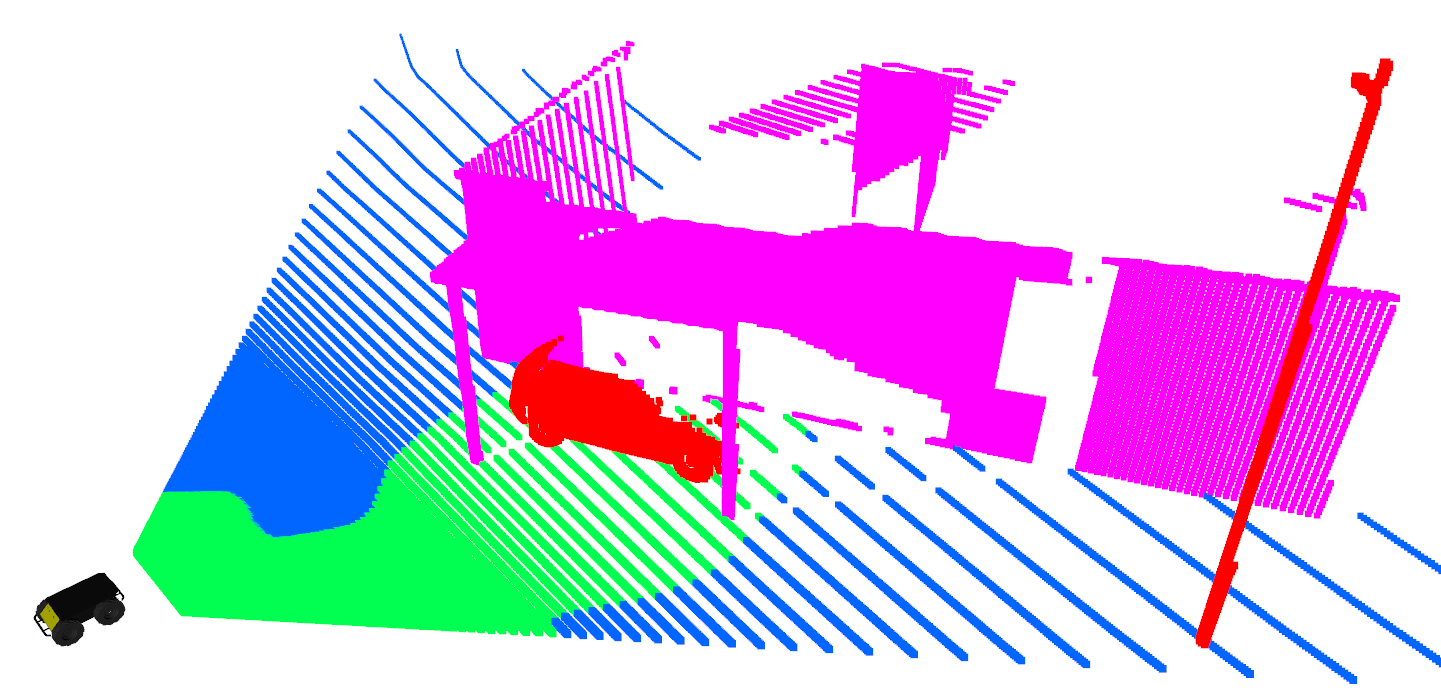
Consider a network of robots represented by an undirected graph where denotes the set of robots and encodes the existence of a communication link between each pair of robots, assumed to be constant throughout the task. The robots are navigating in an environment consisting of a collection of disjoint sets , each associated with a semantic category . Let denote free space, while each for represents a different category, such as building, vegetation, terrain. Each robot is equipped with a sensor that provides a stream of ray-based observations at time . Each observation contains information about the distance to and semantic category of the observed object along the ray. See Fig. 1 for an example. Such information may be obtained by processing the measurements of an RGBD camera or a LiDAR with a semantic segmentation algorithm.
The robots aim to construct a common multi-class map of the environment by utilizing their semantically-annotated local range measurements as well as communication with their teammates. We model the map as a grid of independent cells, where each individual cell is labeled with a category in . To model measurement noise, we consider a PDF for each observation. The goal is to compute the map estimate that maximizes the sum of expected log-likelihood of data, i.e. local observations for each robot :
where and is the space of all probability mass functions (PMF) over the set of possible maps. To remove the constraint , we utilize a multi-class log-odds ratio representation of the categorical distribution [1]:
A probability mass function and its log-odds representation have a one-to-one correspondence through the softmax function :
where is the standard basis vector with -th element equal to and elsewhere, is the vector with all elements equal to , and is applied element-wise to the vector . Applying Bayes rule to the observation model and using the map cell independence assumption makes it possible to solve the optimization for individual cells instead of maintaining the joint distribution over all cells. Thus, the estimation objective can then be written as an unconstrained optimization for each map cell:
where is the temporal geometric average of the inverse observation model. In order to enable distributed optimization of the objective, we introduce a constraint that requires the robots to agree on a common map estimate via only one-hop communication as follows.
Problem.
Let be a network of robots, where each robot collects observations and maintains its own local estimate of the map cell distribution . Estimate the globally consistent common map such that:
| s.t. | (1) |
where is the -th entry of the weighted adjacency matrix of with .
III Distributed Semantic Mapping
The optimization objective in (1) has a specific structure as the sum of local objective functions over all robots, subject to a consensus constraint among all , . We develop an iterative gradient-based method inspired by the general distributed optimization framework presented in [5]. The underlying idea is to interleave local gradient updates for the individual objective function and for the consensus constraint at each robot. Alg. 1 presents the update steps for each map cell in order to solve (1) in a distributed manner. We initialize the log-odds with prior for each robot . We continuously apply the update steps until a maximum number of iterations is reached, or the update norm is smaller than a threshold. The update step in line 7 guides the local log-odds towards satisfaction of the consensus constraint, which only requires single-hop communication between neighboring robots . Line 12 incorporates the local observations via , where is the element-wise multiplication. This step is only local to each robot and does not require communication. Note that both update steps 7 and 14 resemble the log-odds equivalent of the Bayes rule for updating multi-class probabilities (see (8) in [1]). Alg. 1 results in a globally consistent multi-class probabilistic grid map of the environment that is shared amongst all robots in . Proofs of convergence to consensus and optimality with respect to the objective function (1) will be shown in future work.
The distributed semantic mapping algorithm we developed assumes a regular grid representation of the environment. To reduce the storage and communication requirements, we may utilize a semantic octree data structure which provides a lossless compression of the original 3-D multi-class map. In this case, the update rules in Alg. 1 should be applied to all leaf nodes in the semantic octree map of each robot . Please refer to Alg. 3 in [1] for the octree equivalents of the update steps in 7 and 14.
IV Evaluation
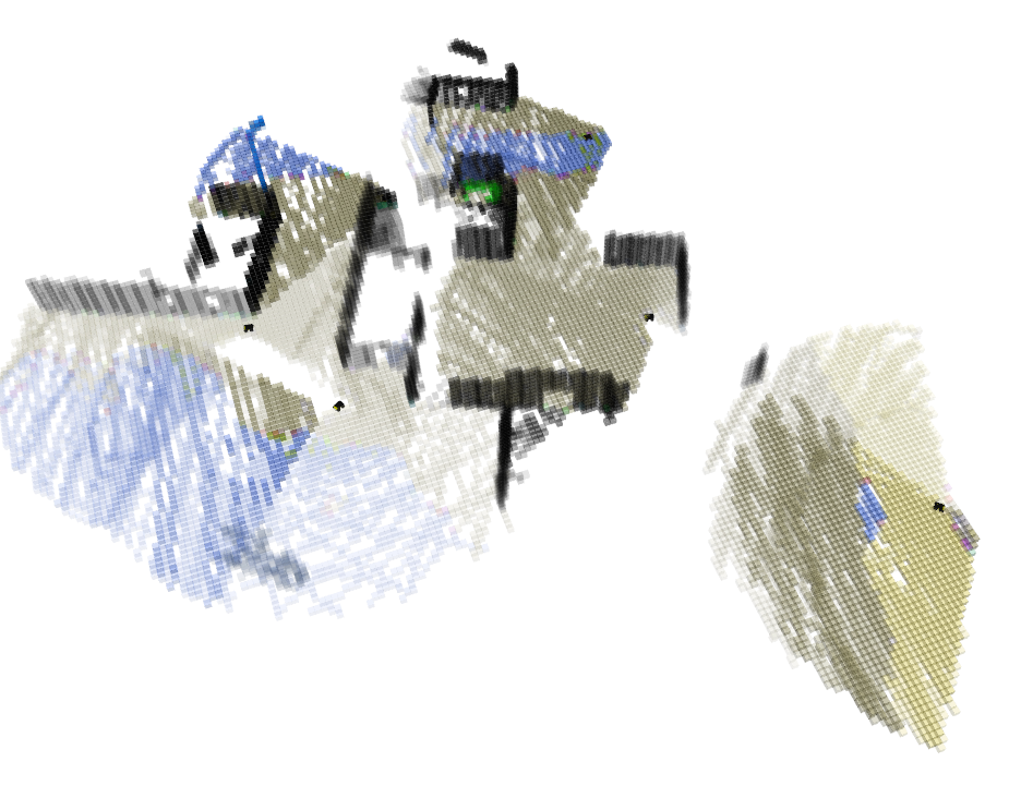
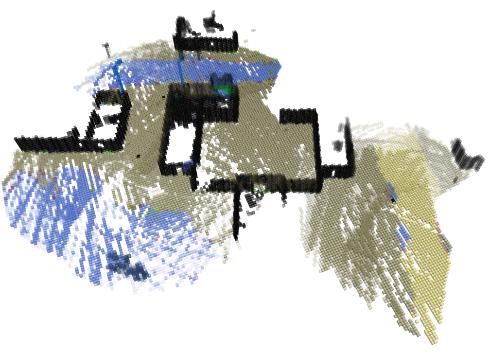
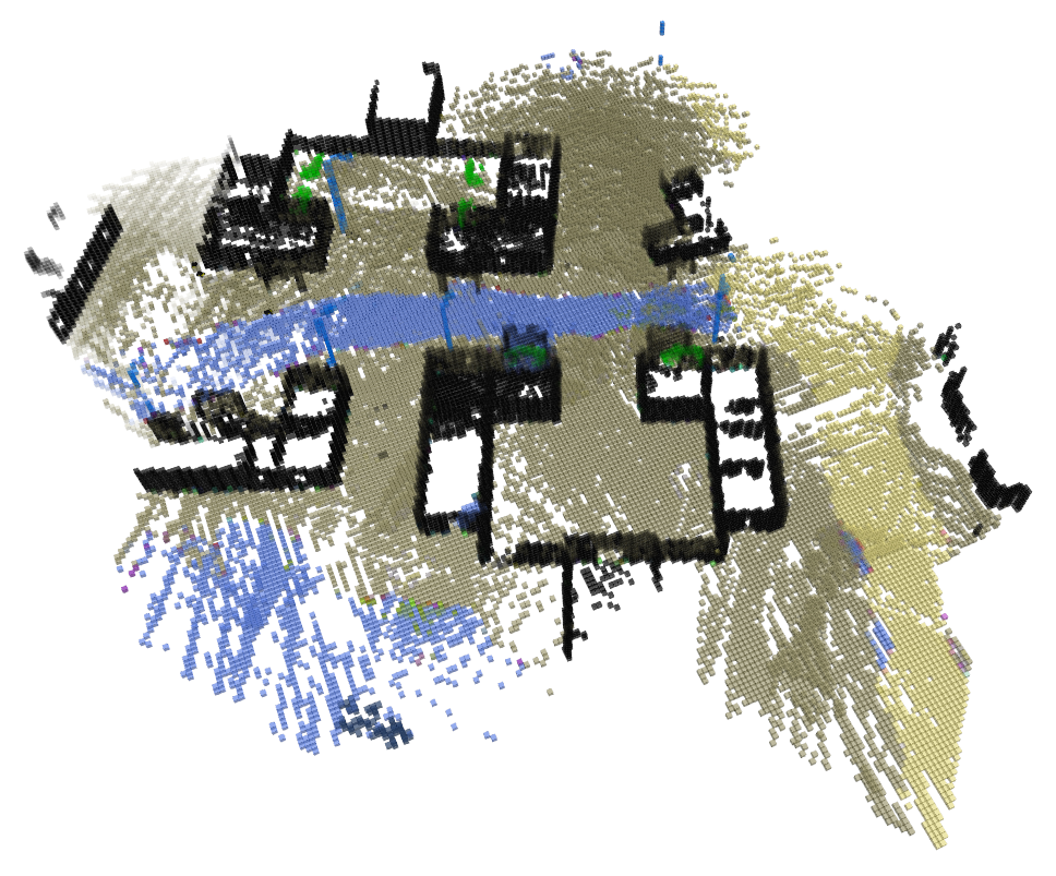
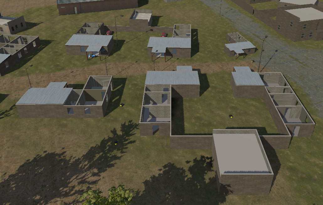
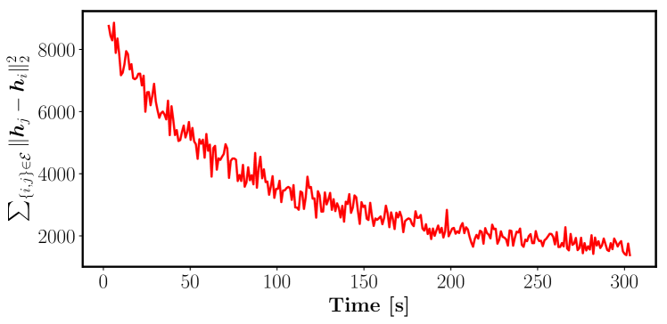
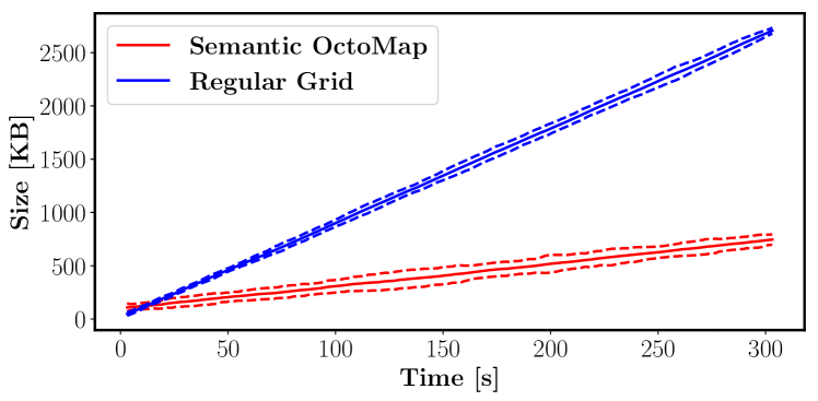
We tested our distributed semantic octree mapping algorithm in a 3-D photo-realistic Unity simulation environment, resembling an outdoor village area with various object classes, such as grass, dirt road, building, car, etc. Six ClearPath Husky robots each equipped with an RGB-D camera explore the unknown environment using frontier-based exploration [6]. The RGB sensor measurements are used to perform pixel classification, which combined with the depth input, are provided as local observations to build semantic octree maps. We assume known robot poses and fully connected communication graph throughout the experiment. Each robot publishes its local map every s, and upon arrival of a map, one iteration of Alg. 1 is executed. Fig. 2 shows several snapshots of the multi-robot semantic octree mapping, as well as the simulation environment. Fig. 3 shows the total distance in local map estimates, i.e. , summed over all semantic octree map leaf nodes. Note that we did not account for the communication strength coefficients since doing so would underestimate the actual divergence in the local map estimates. As the figure shows, our distributed mapping algorithm leads to reduction of the total distance in local map estimates. Regarding communication requirements of our distributed semantic octree mapping, Fig. 4 illustrates the size of the communicated local semantic octree maps, with comparison to running the same distributed mapping experiment using uniform resolution grid maps. Our semantic octree map shows more than four times saving in communication bandwidth, empirically validating the benefit of our map representation for distributed multi-robot applications.
In this work, we presented distributed construction of semantic octree maps of unknown environments using a team of robots. The global map can be accessed via query from any of the robots, eliminating the need for a central estimation unit. Such common map can be utilized by robots for decentralized planning. In a future work, we use our multi-robot mapping algorithm alongside a distributed planning method in order to achieve multi-robot exploration.
References
- [1] A. Asgharivaskasi and N. Atanasov, “Semantic octree mapping and Shannon mutual information computation for robot exploration,” IEEE Transactions on Robotics (TRO), 2023.
- [2] M. Corah, C. O’Meadhra, K. Goel, and N. Michael, “Communication-efficient planning and mapping for multi-robot exploration in large environments,” IEEE Robotics and Automation Letters, vol. 4, no. 2, pp. 1715–1721, 2019.
- [3] P. Paritosh, N. Atanasov, and S. Martinez, “Distributed bayesian estimation of continuous variables over time-varying directed networks,” IEEE Control Systems Letters, vol. 6, pp. 2545–2550, 2022.
- [4] Y. Tian, Y. Chang, F. Herrera Arias, C. Nieto-Granda, J. P. How, and L. Carlone, “Kimera-multi: Robust, distributed, dense metric-semantic slam for multi-robot systems,” IEEE Transactions on Robotics, vol. 38, no. 4, pp. 2022–2038, 2022.
- [5] S. M. Shah, “Distributed optimization on Riemannian manifolds for multi-agent networks,” arXiv preprint arXiv:1711.11196, 2017.
- [6] B. Yamauchi, “A frontier-based approach for autonomous exploration,” in IEEE International Symposium on Computational Intelligence in Robotics and Automation, 1997, pp. 146–151.