Privacy risk in GeoData: A survey
Abstract.
With the ubiquitous use of location-based services, large-scale individual-level location data has been widely collected through location-awareness devices. The exposure of location data constitutes a significant privacy risk to users as it can lead to de-anonymisation, the inference of sensitive information, and even physical threats. Geoprivacy concerns arise on the issues of user identity de-anonymisation and location exposure. In this survey, we analyse different geomasking techniques that have been proposed to protect the privacy of individuals in geodata. We present a taxonomy to characterise these techniques along different dimensions, and conduct a survey of geomasking techniques. We then highlight shortcomings of current techniques and discuss avenues for future research.
1. Introduction
Data privacy is a problem that exists in any data that is about, caused by, or initiated by people (Westin, 1968). Organisations in many business domains increasingly produce large databases with millions of records, which might contain detailed and sensitive information about people, such as customers, patients, taxpayers, or travellers (Drechsler and Hu, 2021). Consequently, concern about the privacy of these data has become a top priority. A violation of the privacy of an individual is the use of personal information other than the norm allows. Thus, data privacy can be viewed as a guideline for how data should be collected or handled, based on its sensitivity and importance. Although contextual integrity clearly defines how a privacy violation could occur in a dataset, it provides no protection mechanism other than policy and regulations (Zandbergen, 2014).
Geo spatial information (we refereed to such data as geodata) at the most detailed level (coordinates) has been recognised as important information in various domains such as epidemiology, medicine, and social science (Fronterrè et al., 2018). The amount of high-resolution spatial data has been enormously growing due to the enclosing of positioning capabilities in mobile, wearable, and global positioning systems. Geo spatial data can be linked with other information to create geocoded data, such as mapping individual’s address details into geographic coordinates. As more and more data is available about individuals, geocoded data enables the accurate identification of individuals’ locations (Sharad and Danezis, 2013; De Montjoye et al., 2013; Unnikrishnan and Naini, 2013).
As geocoded data are becoming available at increasingly finer resolutions, attacker capabilities in linking geocoded data to specific individuals or groups continue to grow. Knowing an individual’s location increases the risk of reidentification by reverse geocoding and can seriously violate the individual’s privacy (Brownstein et al., 2006a; Kounadi et al., 2013). For instance, when publishing a data point, coordinates can be simply calculated and connected with an address. Thus, the address attribute is supposed to be processed as confidential information because it can reveal an individual and, thereby, ought to be deleted before publishing a dataset.
The growing need for protecting discrete geodata results from technological developments and the need of releasing data online. Hence, over the past decade there have been many papers published that proposed different methods to preserve the individual’s privacy, such as geomasking techniques (Zandbergen, 2014). Geomasking techniques are meant to secure confidentiality when publishing geodata while preserving geographic detail to enable a precise spatial analysis of the dataset (Kwan et al., 2004a; Gambs et al., 2014; Wang et al., 2022). These techniques aim to obfuscate the real locations of an individual. For example, using geomasking the address of an individual does not have to be eliminated but can be transferred to a different position thus avoiding the deletion of the addresses from a published dataset results in a less accurate data utility.
Geomasking techniques aim to obfuscate the real locations of an individual. However, there is no generally recommended nor approved geomasking techniques. Each geomasking method has disadvantages and advantages. Moreover, no geomasking method currently applicable is able to serve a thorough solution to protect location privacy. Thus, an in-depth analysis of the capabilities of each geomasking technique is required to better utilise these geomasking techniques in real applications.
Contribution: In this paper we conduct a comprehensive survey on geomasking techniques. To guide our survey of geomasking techniques, we propose a taxonomy that we used to review geomasking technique under different dimensions in this article. At a high level, this taxonomy differentiates between geomasking techniques in terms of the way how each technique can be used to anonymise geo data, different evaluation measures that can be used to evaluate these technique, and practical aspects that are important when implementing and experimenting these techniques. The goal of this proposed taxonomy is to allow data custodians to easily navigate the large list of existing mechanisms and identify the mechanisms that could be fit-for-purpose for their needs. We acknowledge that other taxonomies could have been equally adopted and that some of these alternatives may be more useful for other readers of this survey (e.g., scientists looking for knowledge gaps in the area).
Comparison to other works: Several surveys have studied the geomasking techniques. Boulos et al. (Kamel Boulos et al., 2022) provides a comprehensive overview of location privacy issues and geoprivacy-preserving methods within the realm of public health interventions and health research with aggregate geographic data. The survey delves into critical challenges related to location privacy, particularly in the context of public health crises like the COVID-19 pandemic.
Maike et al. (Steffen et al., 2023) systematically reviewed the existing literature on data protection strategies for geocoded data and classifies them into aggregation, geographic masking, and synthetic data. The survey also discusses various tools for assessing the risk and utility of protected geocoded data. (Kim et al., 2021) investigated how do different geomasking methods impact perceived disclosure risk. The findings reveal that perceived disclosure risk increases with the amount of locational information on a map. The study suggests that some geomasking methods such as aggregation methods could contribute to decreased perceived disclosure risk.
Some studies have explored the applicability of geomasking techniques in specific domains. Nowbakht et al. (Nowbakht et al., 2022) investigated the challenge of balancing confidentiality and spatial pattern preservation in sharing agricultural data. (Tiwari et al., 2023) focuses on the ethical use of geographical information systems (GIS) data, specifically discussing geomasking for locational privacy. (Hu, 2019) focuses on Bayesian methods for estimating disclosure risks in synthetic data, emphasising their construction and application. Iyer et al. (Iyer et al., 2023) categorises geomasking algorithms into aggregation, affine transformation, and random perturbation, offering a comprehensive exploration of each method’s advantages and drawbacks. The study also delves into the evaluation criteria for geomasking procedures, emphasising the importance of analytical accuracy and privacy protection. The thesis(Kekana, 2020) focuses on evaluating four masking methods—grid masking (GM), random perturbation (RP), weight random perturbation (WRP), and Voronoi masking (VM)—with the goal of presenting the sleeping locations of the homeless without compromising their spatial confidence.
(Broen et al., 2021) investigates the impact of various data perturbation methods on both key spatial statistics and patient privacy. The study investigated distinct perturbation approaches ranging from non-aggregating techniques like random perturbation, and Voronoi masking, to aggregating perturbations such as grid line masking and grid center masking. (Wang et al., 2022) conducted a comprehensive evaluation of eight geomasking methods using simulated geospatial data with diverse spatial patterns to assess their effectiveness in privacy protection and analytical accuracy. The recent thesis by Redlich (Redlich, 2022) presents a comprehensive evaluation of geomasking methods designed to balance individual privacy protection with the preservation of spatial information utility. This work provides valuable insights into geographic masking methods’ strengths, limitations, and privacy implications, forming a basis for informed decision-making in spatial data analysis. However, the authors did not analyse the geomasking techniques under the dimensions that are important for practical applications but only viewed from a risk and utility perspective.
Further, different studies (Dupre et al., 2022; Löffler et al., 2017; Seidl et al., 2018; Gao et al., 2019) conducted comprehensive explorations of challenges associated with the increasing availability of geocoded data and the growing capabilities of attackers to link such data to specific individuals or groups. Overall, these studies highlights the need for further research to compare the effectiveness of different masking methods, determine optimal displacement levels for confidentiality, and explore alternatives to geographic masking for protecting individual-level geodata.
Outline: The rest of this paper is structured as follows. First, in the following section, we provide an overview of geomasking where we discuss different types of geodata and different privacy attacks on geodata. In Section 3 we then present a taxonomy on geomasking where we describe the 10 dimensions we identified that allow us to characterise geomasking techniques. In Section 4 we then survey existing geomasking techniques, and describe how they fit into our taxonomy. We then discuss open issues in existing geomasking techniques and directions for future research in Section 5, and we conclude this paper in Section 6 with a summary of our findings.
2. Background
This section provides necessary background details on geomasking, starting with different types of geodata and then an investigation into different attacks on geodata.
2.1. Different types of Geodata
Geo data consists information that describes objects, events or other features with a location on or near the surface of the earth. Geo data is information recorded in conjunction with a geographic indicator of some type. There are two primary forms of geo data: vector data and raster data. Vector data is data in which points, lines and polygons represent features such as properties, cities, roads, mountains and bodies of water. For example, a visual representation using vector data might include houses represented by points, roads represented by lines and entire towns represented by polygons. Raster data is pixelated or gridded cells which are identified according to row and column. Raster data creates imagery that’s substantially more complex, such as photographs and satellite images.
Apart from vector and raster data, location information can be come in the forms of census data, mobility data, drawn images, and social media data. In census data can contain data that tied to specific geographical areas and thus statistical analysis can be conducted on data attached to different geographical locations. Mobility data provides information regarding locations and movements of individuals. Individuals will generate mobility data about their movements through tagging locations on social media, using apps which collect location data such as mapping apps, through interacting with wifi beacons, or in some cases from bluetooth, GPS or mobile phone records.
Mobility data can usually be captured as GPS location coordinates and also based on the connectives an individual’s mobile make with mobile cell towers. Such data can also be used to perform geospatial analysis. Drawn images such as CAD images providing information of building or other structures providing geographical information. Finally, social media data can also contain data about people movements as they post information regarding the places that a person has visited.
2.2. Different Privacy attacks on Geodata
Geodata privacy refers to a set of principles and practices put in place to protect the confidentiality of individuals,groups, communities or organisations about whom there is geographically explicit data collected. Geocoded data are becoming available at increasingly finer resolutions, while attacker capabilities in linking geocoded data to specific individuals or groups continue to grow. The number of identifying variables necessary for a data breach to occur is reduced dramatically when geographic location is known at a precise level, especially where population density is low. The development of geocoded data sources presents new concerns for data confidentiality breaches, as traditional disclosure avoidance mechanisms may ignore spatial characteristics. In this section we explore different privacy issues for geodata.
2.2.1. Reverse Geocoding
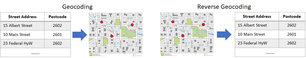
Geocoding refers to the process of assigning geographic coordinates to addresses or place names. However, the release of geographic information at the individual level can breach privacy and confidentiality. For example, publishing the street address of an individual makes it possible to look up the associated name(s) in directories and property databases. Publishing a location as coordinates means that these can be plotted on a map and then associated with an address. Publishing a map in paper or digital form also means that the locations can be associated with an address.
Reverse geocoding occurs when the address details for a location published is determined. Address details can then be a powerful key for linking the data associated with those coordinates to specific and identifiable information from other sources. For example, in an application domain of census data, the locations of the respondents can be inferred and reverse geocoded if a census area has low-value cells leading to possible disclosure. Reverse geocoding can lead to re-identification because the street address can then be associated with one or several individuals using common directories. Figure 1 illustrates an example of geocoding and reverse geocoding processes of addresses (Kounadi et al., 2013).
Several research works have shown that re-identification of individual addresses using reverse geocoding. In 2006, Brownstein and others (Brownstein et al., 2006a) were able to correctly identify more than 70% of the addresses in a published map using manual reverse geocoding techniques in GIS. The same authors showed similar accuracy in identifying addresses can be achieved using semi-automated reverse geocoding based on image analysis (Brownstein et al., 2006b). In realistic examples, a group of researches from US correctly identified most of the original residence of mortality locations of Hurricane Katrina using a published map in a local newspaper (Curtis et al., 2006). Further, another study of crime incidents in Vienna, Austria showed that individuals could be accurately re-identified using online reverse geocoding and online address and telephone directories.
2.2.2. Geocoding of administratively-masked data
Helderop et al. (Helderop et al., 2023) recently proposed a geocoding method for unmasking administratively-masked data where specific identifying features, like addresses, are obscured to protect privacy. The proposed approach utilises a medoid-based technique, aiming to minimise spatial uncertainty associated with the masking process. The method utilises a master address point dataset to generate a list of candidate addresses for each masked observation, and a minimum bounding polygon is drawn around these candidates. The medoid, representing the central-most point, is then identified within this polygon and assigned as the geocoded address. The approach outperforms commercial geocoding software, providing higher accuracy and a spatial confidence metric for each result.
2.2.3. Inferencing attack
An inference attack corresponds to a process by which an adversary that has access to some data related to individuals (and potentially some auxiliary information) tries to deduce new personal information that was not explicitly present in the original data. For geographical data, the inferencing attacks have been studied for a long time (Sharad and Danezis, 2013; De Montjoye et al., 2013; Unnikrishnan and Naini, 2013). The most common inferencing attack type applied on geo data is de-anonymising attacks (Gambs et al., 2014). The de-anonymising attack aims to re-identify individuals using their anonymised location data.
Gambs et al. (Gambs et al., 2014) proposed a de-anonymising attack where an adversary tries to infer the identity of a particular individual using their mobility traces. More precisely, the proposed attack can re-identify individuals with a high success rate whose movements are contained in an anonymous dataset provided that the adversary can used as background information some mobility traces of the same individuals that he has been able to observe during the training phase.
Wang et al. (Wang et al., 2016) proposed a new model to profile users’ spatio-temporal mobility behaviours and use the model to launch the de-anonymisation attack. The authors used User Hidden Markov model to profile the user movements and used an algorithm to rank the users based on the probability that each individual matches with a given profile.
A recent work by Eshun and Palmieri (Eshun and Palmieri, 2022) proposed two de-anonymisation techniques using hidden markov models. In their attacks both the temporal and spatial influences on user mobility trajectories are considered for making prediction on users movemement. These predictions are used to create a profile for each individual and the re-identification of individuals based on these user profiles are performed based on a divergence measure. An experimental evaluation on real-world mobility traces showed that their proposed attack can achieve over 80% of accuracy in re-identifying individuals.
2.2.4. Differencing attack
A differencing attack is possible with variables for which there are multiple different plausible coding schemes, where the categories in those coding schemes are not nested but instead overlap. For example, given a table with information on 20–25 year olds and a table with information on 20–24 year olds, then the difference between the two tables will reveal information about 25 year olds only. If the difference between cells contains a small number of individuals then a disclosure is more likely.
Differencing attacks occur when data released at different levels of geography can be combined to reconstruct data at a smaller level or identify the location of an observation. This situation may occur for tables or maps with different geographical codings potentially allowing more information to be revealed about individuals in the overlaps than intended from each individual table. Although it could happen with any variable the issue most commonly comes up with geography. The result of this differencing is that whilst a table may be considered safe in isolation, this may not be the case for multiple tables when overlain with one another.
3. A Taxonomy of Geomasking
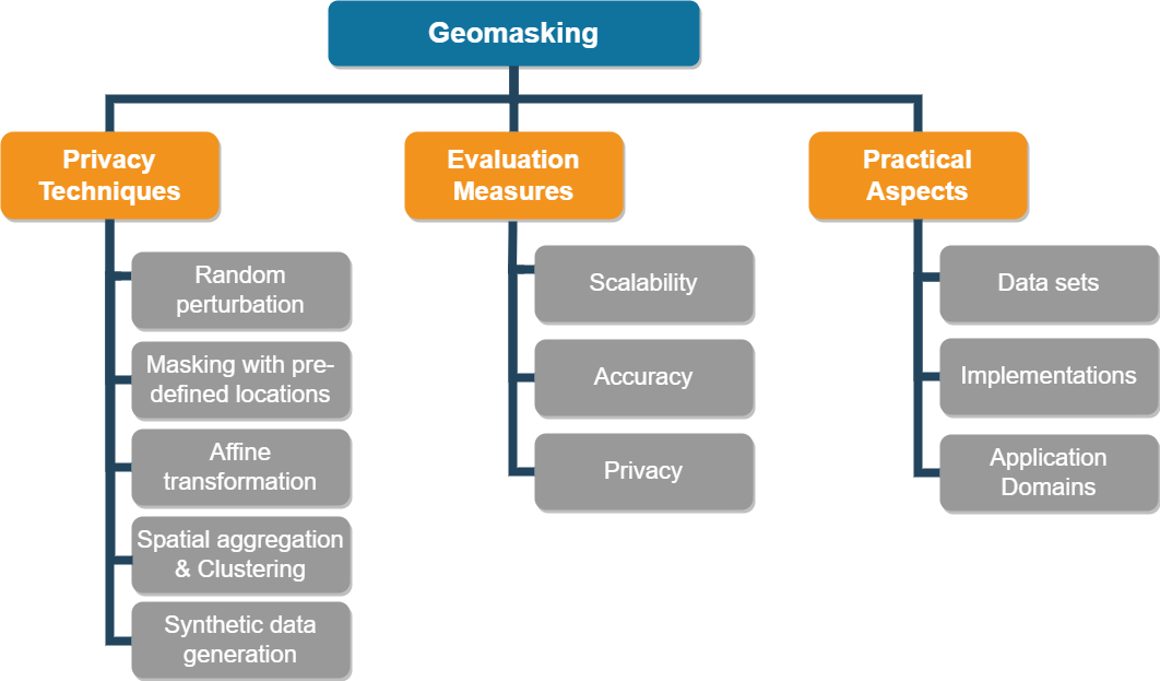
In this section we describe a taxonomy for geomasking techniques. Our aim in developing this taxonomy is to provide a clearer picture of current approaches to geomasking, and to identify gaps in these techniques which will help us to identify directions for future research. We describe 11 dimensions of geomasking which we categorise into three main topics, as is illustrated in Fig. 2. Combined, these 11 dimensions provide a comprehensive characterisation of geomasking techniques. In the following sub-sections we discuss each dimension in detail, and we provide an overview of the major methodologies or techniques applied in these dimensions.
3.1. Privacy techniques for Geomasking
Geomasking is a class of methods for changing the geographic location of an individual in an unpredictable way to protect confidentiality, while trying to preserve the relationship between geocoded locations and occurrence events. In this section we analyse different privacy techniques proposed for geomasking.
Following earlier work on geomasking (Stinchcomb, 2004), we group geomasking techniques into five major categories: (1) random perturbation, (2) masking with pre-defined locations, (3) affine transformation, (4) aggregation and clustering, and (5) Synthetic data generation . In the next subsections we discuss different techniques that are proposed under each of these categories in more details.
3.1.1. Random Perturbation
Random perturbation geomasking moves each individual points from their original location to a random distance in a random direction (Allshouse et al., 2010). When the generated masked points may be close to the original points and for a small proportion of the geomasked points, the adversary can re-identify individuals by reversing geocode. Next, we explain several techniques that can categorised under random perturbation.
3.1.1.1 Density-adaptive displacement
In this category, the displacement distance is inversely proportional to the underlying population density. In the geomasking literature the population densities can be considered either as uniform or heterogeneous.
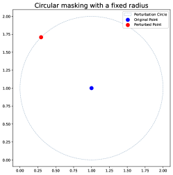
Uniform population density distribution: The methods under this category assume the population density is distributed homogeneously. Figure 3 illustrates the different method under this category.
-
(1)
Circular masking with a fixed radius: This method generates random locations on a circle around the original points by a predetermined displacement distance while ensuring that the perturbed location points do not fall within the circle (Kwan et al., 2004a).
-
(2)
Circular masking with a random Radius: This method randomly displaces points both in direction and distance within a circular area from their original positions, ensuring they remain confined within the boundaries of the circle (Armstrong et al., 1999; Kwan et al., 2004a). All locations inside the circle have an equal chance of being selected.
-
(3)
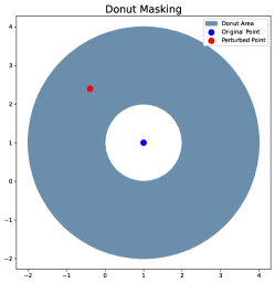
Donut Masking (random perturbation within an annulus): The donut method extends current methods of random displacement by ensuring that an address is not randomly assigned on or too near its original location. In donut method geomasking, each geocoded address is relocated in a random direction by at least a minimum distance, but less than a maximum distance. In addition, each point is moved a distance inversely proportional to the underlying population density, which provides privacy protection while minimising the introduced spatial error. For example, persons in high-density urban areas do not need to be moved as far as persons in low-density rural areas to achieve the same magnitude of anonymisation. The donut method is an adaptive geomask because the dimensions of the mask around each point vary to meet specified anonymity constraints based on the underlying population density. However, in cases where population density is not evenly distributed, there may be an under-protection of individuals (Allshouse et al., 2010).
Heterogeneous population density distribution: The methods under this category assume the population density is distributed non-homogeneously.
-
(1)
Spatially adaptive random perturbation (SARP): This technique considers the spatial variation of the population at risk when displacing points by random distances and in random directions (Lu et al., 2012). It reduces unnecessary noise in high-dense population zones by using relatively large and small population zones for low and high population densities, respectively. The SARP geomasking technique defines the perturbation zone based on the actual distribution of residential addresses (risk location) instead of people (risk population). It employs ”donut-shaped” spatially varied perturbation zones rather than ”pancake-shaped” which allows a point to be moved to a nearby location within its immediate surroundings. Utilising actual street addresses the SARP geomasking technique could offer better privacy protection compared to geomasking based on population size. While the SARP techniques do not significantly alter clustering patterns on a global scale, the geomasked data tends to exhibit greater clustering compared to the real distribution.
-
(2)
Weighted random perturbation (WRP): Weighted random perturbation is included because of its potential to better preserve spatial distributions by displacing points shorter distances in more populated areas (Kwan et al., 2004b). The weighted random mask aimlessly rotates every data point on a circle applying the variable radius , where depends on the underlying population density. This approach enhances privacy protection by mitigating the risk of disclosing spatial information. Additionally, it imposes a maximum displacement limit based on the distance to each point’s -th nearest neighbour.
3.1.1.2 Gaussian deviation for displacement magnitude
There are several methods that can be considered under this category.
-
(1)
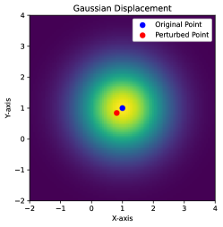
Gaussian displacement: This method moves location points to a random direction, and the magnitude of displacement conforms to a Gaussian distribution (Cassa et al., 2008; Fanshawe and Diggle, 2011; Zandbergen, 2014). However, the Gaussian displacement’s main challenge lies in the limited point displacement due to its concentration around the mean. Figure 4 (left plot) illustrates this method.
-
(2)
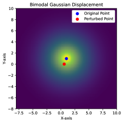
Bimodal Gaussian displacement: This technique is an adaptation of Gaussian displacement, employing a bimodal Gaussian distribution to determine random distances for the masked locations (Cassa et al., 2006; Zandbergen, 2014). It shares similarities with donut masking but offers a probability distribution that is less uniform. Figure 4 (middle plot) illustrates this method.
-
(3)
Density–based Gaussian spatial skew: In this method the location points are adjusted by applying a random offset derived from a Gaussian distribution, where the standard deviations of the distribution are inversely related to the population density in the local area (Cassa et al., 2006). Utilising local demographic data allows the proposed anonymisation system to shift individuals in heavily populated regions by shorter distances compared to those in sparse areas. Consequently, addresses can undergo minimal distortion while upholding a designated level of k-anonymity.
3.1.1.3 Multiple risk factor adaptive displacement
This category incorporates various factors in calculating displacement distances, including but not limited to population density. Triangular Displacement is a method that can be considered under this category. Triangular Displacement method considers population density for displacement distances, incorporates multiple factors, such as individual re-identification risk, data sensitivity levels, research types, the presence of quasi-identifiers, and potential exposure to external sources, to calculate displacement distances (Murad et al., 2014). However, this technique has limitations. Triangular Displacement method may be vulnerable to edge effects and could result in masked locations falling into impractical or unrealistic areas, thereby impacting data confidentiality. Despite these limitations, this method represents a step forward in geomasking techniques, offering a more nuanced and context-aware approach to safeguarding spatial data in research and analysis.
3.1.2. Masking with pre-defined locations
The proposed methods under this category move a given point to a new location, which is randomly chosen from all the possible locations of a similar type that exist within a specific region (i.e., a circle or an annulus) surrounding the original location.
3.1.2.1 Location Swapping
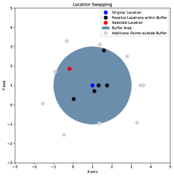
Location swapping method swaps a given location/point to a new location based on the similar geographic characteristics of a point within a specified neighbourhood (Zhang et al., 2017). The method first predefined a radius around the location to be swapped. Then the method randomly selects a location among all the possible locations that falls within the defined radius. This method is similar to the random perturbation within a circle due to couple of reasons: (1) Within the predefined radius all the locations are considered with equal probability making the swapping to any location possible within the defined radius and (2) the radius can be defined based on the underlying population density distributions. However, the location swapping method considered only the locations that have predefined locations (such as residential addresses) as possible candidates for swapping and the radii can be varied based on the local population densities. Figure 4 (right plot) illustrates an example of location swapping.
3.1.2.2 Location Swapping within Donut
This method represents another variation of location swapping, employing the concept of donut masking to set a minimum distance, preventing points from being swapped with any locations within this specified range (Zhang et al., 2017). The determination of this minimum distance can be based on local population densities. The authors employed an internal buffer size half that of the external buffer.
3.1.2.3 Street Masking
Similar to Location swapping, in the street masking method the original location is replaced with coordinates of a point sampled from a set of points within a predefined radius (Swanlund et al., 2020b). However, for sampling this method uses road networks from a given map instead of using residential addresses. However, when selecting points, points that are not close to a drivable road (such as in rural areas) are additionally moved, as all points are first moved to the nearest road that is applicable. Similar to location swapping, street masking can utilise the population densities when determining the radius assuming that areas with a high population density also have high road density and vise versa. However, for high road density areas this method could consume larger runtime due to the number of points to be masked.
3.1.3. Affine-Transformation
The transformations techniques, which is also known as isomasks techniques, apply basic geometric transformations to move spatial point data (Ajayakumar et al., 2019). Here, it can be differentiated between rotate, scale and translate, stochastic mechanism, and concentration of isomasks. Affine transformations change the original location by either twisting every point by a set angle (referred to as rotation), or moving every point by a set increment (referred to as translation) or by moving every point by scaling constant (referred to as scale). Next, we describe these methods in more details and Fig 5 illustrates some of these methods.
3.1.3.1 Translation
This method adds a random constant displacement value to both x and y coordinates while ensuring the distance between coordinates remains the same (Wang et al., 2022). All points will be shifted to a fixed distance and direction.
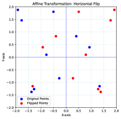
3.1.3.2 Flipping
This method manipulates the orientation of axes, both on a local and global scale. There are several flipping techniques, such as global horizontal flipping, which flips the map’s horizontal axis, global vertical flipping, which flips the map’s vertical axis, global axes flipping, which flips both horizontal and vertical axes, and local random flipping, which randomly alters the orientation of horizontal, vertical, or both axes within grid cells to hide location points (Gupta and Rao, 2020; Leitner and Curtis, 2004, 2006).
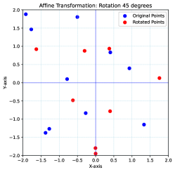
3.1.3.3 Rotating
This method rotates each point by a fixed angle (), centering the rotation around either the origin of the coordinate system or an arbitrarily chosen point (Wang et al., 2022).
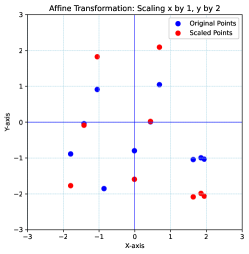
3.1.3.4 Scaling (Resizing)
This method multiplies a constant value with both x and y coordinates, which remains consistent for both axes (Wang et al., 2022). Consequently, this process alters the distances between the points and all points will be expanded by a scaling factor.
3.1.3.5 Horizontal shear
3.1.4. Spatial aggregation & Clustering
Spatial aggregation aggregates individual location points within specific geographic units or areas, such as cities, zip codes, or administrative areas, to ensure anonymity and prevent the disclosure of exact locations. This technique operates by decreasing the spatial resolution of the data, thereby modifying the original data patterns. The goal is to generate generalised records that consolidate information within defined territories, protecting the identities of specific locations. However, this process may compromise the utility of published records as the detailed patterns found in high-resolution data might not be as discernible in the aggregated information.
Clustering aims to reveal inherent patterns within spatial data by grouping similar data points based on geographical proximity or shared characteristics. Clustering maintains the overall characteristics of an area without pinpointing precise locations, preserving the general patterns while ensuring individual data privacy. However, it’s essential to note that the scalability and computational complexity of clustering algorithms can present challenges, especially when handling large and diverse spatial datasets. Figure 6 illustrates several technique under this category.
3.1.4.1 Grid-based aggregations
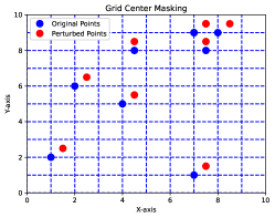
The techniques in this category involves the realignment of individual data points onto a grid system (Leitner and Curtis, 2004). It typically involves relocating each original data point to specific positions within designated grid cells. These relocations may take place at either the centroid or vertices of the grid cells, each being aligned with a defined side length. The efficacy of methods within this category is notably influenced by two crucial parameters, (1) the size of the aggregation units and (2) the boundaries utilised to define these units.
In grid based aggregations the grid cell size could be fixed or varied. Grid line masking and grid center masking are two popular methods that use fixed size grid cells. Grid line masking method relocates location points to the nearest edge of the grid cell in which they are contained (Gupta and Rao, 2020). Grid center masking method relocates the location points to the centroid of the cell in which they are presently situated (Leitner and Curtis, 2004).
-
(1)
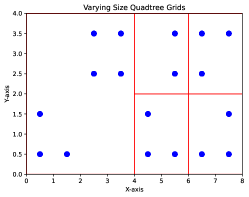
Quadtree hierarchical geographic data structures is a method that uses varying-size grid cells. This method employs a quadtree methodology on an initial 1km2 European grid and population data points to create a grid with varying sizes that can be adjusted according to local population density(Lagonigro et al., 2017). In this approach, densely populated areas are divided into smaller square areas to ensure accurate data dissemination, while sparsely populated areas are grouped into larger areas to prevent the identification of individual data.
-
(2)
Military Grid Reference System (MGRS) protects sensitive point-based geospatial data with a focus on preventing the matching of points with their true underlying observations, such as street addresses. This method involves converting coordinates to the Military Grid Reference System (MGRS) and using digit switching for masking, allowing encryption at different spatial precision levels (Clarke, 2016). The selection of the digit switching combination minimises differences in aggregate descriptive spatial statistics between the masked and unmasked data, with emphasis on the nearest neighbour statistic. Despite the computing time required for processing, the method offers new possibilities for protecting sensitive geospatial data, overcoming disadvantages of geometric point masking methods, such as the lack of control over parameters, compromised spatial analysis of distribution, and susceptibility to violations of geoprivacy associated with the use of high-resolution imagery and accurate data from Global Navigation Satellite Systems (GNSS). The proposed digit-switching method, which operates effectively across multiple nested spatial scales, addresses these limitations by allowing the analyst to choose a distribution that closely mimics the spatial distribution of unmasked data, ensuring suitability for spatial analysis based on aggregate descriptive statistics.
3.1.4.2 Spatial tessellation-based techniques
Spatial tessellation methods encompass techniques for dividing geographic areas into smaller, more manageable units while retaining the spatial integrity of the original data.
-
(1)
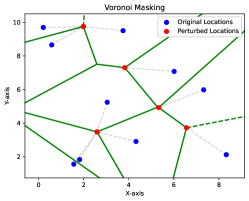
Voronoi masking: Voronoi polygons define areas where the boundaries are equidistant between the surrounding points, or where inside the polygons is closer to the corresponding point than to any other point (Seidl et al., 2015). In voronoi masking, each point is snapped to the closest part along the edges of its corresponding Voronoi polygon. An advantage of this technique is that where the density of original points is higher, the points are moved a shorter distance, resulting in patterns that more closely resemble the original data. The voronoi masking pattern is strongly linked to the residence distribution of the specified study area. Another advantage of voronoi masking is that some points in adjacent polygons will be snapped to the same location, which can increase their k-anonymity.
-
(2)
Adaptive areal elimination (AAE): This method establishes zones with a minimum level of K-anonymity (Kounadi and Leitner, 2016). Initially, address points are grouped into polygons if available. Subsequently, a disclosure value for ”RoRi” (risk of re-identification) is determined, representing the minimum K-anonymity threshold at which sensitive information can be revealed. The method involves a dissolving process, where polygons with RoRi values below the set threshold are merged with neighbouring polygons until all polygons reach or exceed the threshold. This merging process follows a spatial guideline based on shared borders, primarily prioritising neighbours with the longest shared border. In the case of equilateral polygons, they undergo the dissolving process with all adjacent polygons. Ultimately, this process results in the creation of K-anonymised areas where the disclosure threshold is met. Location points within these areas can be relocated to the centroids of the K-anonymised zones or randomly distributed within them to ensure anonymity.
-
(3)
Adaptive areal masking (AAM): This method represents an enhanced iteration of AAE (Charleux and Schofield, 2020). In AAM, specific anonymisation polygons are constructed for individual points by iteratively merging them with the nearest centroid-based polygon, followed by the next closest, until the k-anonymity threshold is met. This approach preserves data more effectively than AAE because aggregation stops when the desired k-anonymity level is reached. Additionally, it minimises point displacement by initially merging smaller polygons. Although merged polygons may not always be adjacent, this method is more resource-efficient than verifying adjacency. It further conserves resources by excluding polygons with no points to anonymise, which can be a majority in some applications. Lastly, the process is amenable to parallelisation as each point is treated individually, enhancing efficiency.
-
(4)
Adaptive voronoi masking (AVM): This method integrates the principles of AAE and VM to preserve data utility, considering topological polygon relationships and underlying topography, and achieve a high-level of spatial k-anonymity to mitigate re-identification risks(Polzin, 2020). A key strength of AAE lies in accounting for underlying population density, while VM excels in displacing the Original Data Points (ODP), generating masked patterns similar to the ODP’s distribution. However, both VM and AAE exhibit drawbacks: they overlook the underlying topography, potentially placing data points in illogical locations such as lakes or forests, leading to false re-identification risks. AVM bridges these gaps by integrating the benefits of AAE’s population density consideration and VM’s ODP displacement method. It moves ODPs to the closest segments of their corresponding Voronoi polygon within the merged AAE-polygon, mitigating the risk of displacing points to areas with different population thresholds. Additionally, AVM addresses topographical concerns by relocating data points to the nearest street intersection, minimising false re-identification and illogical placements in water bodies or forests.
-
(5)
RDV masking: This method, known as the three-layer RDV masking model, is based on rudimentary triangulation and Voronoi generation(Gupta and Rao, 2020). It is intended to be used at the research analysis stage before sharing final data publicly. The masking process is centralised, applying masking to specified nodes at one point. The key advantage of this solution is its ability to not only efficiently mask points but also retain the spatial pattern of the original data, considering various indicators beyond population density. The RDV masking method is structured into three distinctive layers, each contributing to the overall masking process. The first layer, termed layer R, initiates by spatially distributing a given set of points throughout the region, ensuring the preservation of the original point configuration for later comparison and analysis. Moving to layer D, the process progresses to computing the Delaunay triangulation of the given point set, utilising a Divide and Conquer strategy to efficiently accomplish this phase, albeit with a specific computation duration. Finally, layer V, the last phase, focuses on separating individual points to their nearest segment along the edges of the corresponding Voronoi polygon. This step is pivotal in upholding the original density patterns of the points, employing Fortune’s Algorithm for computation, which also entails its specific computation duration. Together, these layers encapsulate a comprehensive approach to masking, offering spatial distribution, triangulation, and precise segmentation to maintain original data patterns effectively.
-
(6)
Zip4-codes aggregation: This method uses Zip4 (postal) codes as a spatial aggregation unit for sharing fine-scale health data while addressing privacy concerns (Ajayakumar et al., 2023). The Zip4 aggregation preserves the underlying spatial structure making it potentially suitable for geospatial analysis.
3.1.4.3 Differentially private clustering
Differential privacy is the current state-of-the-art technique for controlling risk of identity disclosure, that greatly reduces the disclosure risk issues in k-anonymity, l-diversity and other extensions by leveraging randomisation with noise addition (Dwork, 2006). An algorithm is said to be differentially private if the operation of that algorithm on the data set produces essentially the same answers regardless of the presence or absence of an individual.
The main drawback of using differentially private algorithms for data analysis is that, like the other perturbation methods, it does not preserve the accuracy of the algorithms applied to the original data, and in fact will deviate more from the results based on the original data in proportion to the privacy guarantees that it provides (Dwork, 2008). Further, differential privacy does implicitly assume that all information about an individual participant is contained within a record and that records are independent. It is not appropriate to input a data set containing multiple records per person, into a differentially-private mechanism given if records are correlated, the privacy protections may become weaker.
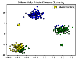
Differential privacy has been used for querying geospatial data sets in a privacy preserving manner (Xiao and Xiong, 2015; Harris, 2020). Apart from applying differential privacy for statistical queries, differential privacy has been utilised for geospatial clustering. Clustering on geospatial data can inadvertently create vulnerabilities that adversaries with background knowledge can exploit to breach individuals’ privacy. To safeguard individual privacy from such risks, significant research has been devoted to preserving differential privacy in clustering algorithms (Yan et al., 2022; Wang et al., 2017; Qardaji et al., 2013; Lu and Shen, 2020). Figure 7 illustrates how original k-means clustering (left plot) and how differential privacy based k-means clustering (right plot) protects location privacy.
3.1.5. Synthetic data generation
This technique allows mixing up the elements of an dataset or creating new values based on the original information—so the overall totals, values and patterns of the data are preserved but do not relate to any particular individual (Sakshaug and Raghunathan, 2014). Synthetic data can be generated in a number of ways. (1) Using a generative computer model or generated adversarial network (GAN) to create a set of data points that cannot be differentiated from the real data. In generative models, algorithms are fed with smaller real-world data which then gets derived by the algorithms to create similar data. (2) Enhanced sampling either with over-sampling the minority class or under-sampling the majority case to create a synthetic distribution of data. Finally, (3) an agent based simulation which uses a simulation process where agents are developed to represent real-world entities that interact with each other, and these interactions are observed and measured to generate synthetic data.
Using above methods, the data can be generated either partially or fully synthetic (Hu and Drechsler, 2015). In partially synthetic data only attribute values that are sensitive are replaced with synthetic data. In fully synthetic data generation an entire data set (rather than a sample of data) is replaced with synthesised replacement data. However, synthetic data is dependent on the model that is used to generate or derive synthesised replacement data. If the initial model is not sufficient to create quality synthetic data, the generated data will be less reflective of original data.
Synthetic data generation becomes especially crucial when working with geocoded data, such as addresses or coordinates, as releasing them in their raw format can introduce substantial privacy risks (Nowok and Dibben, 2018). Synthetic data that replicates the structure and statistical properties of the original geospatial data set without using original content offer a way to enhance the use of confidential microdata, also with detailed geographic identifiers. These data sets can be used to conduct reliable inference in many analyses but in some cases they will give approximate results at best. The choice of a specific synthetic data set for release from all the versions created depends on the intended level of geographical analysis and the desirable risk-utility profile (Quick et al., 2015).
3.2. Evaluation measure for Geomasking
The performance of the geomasking techniques can be evaluated in terms of how efficient and effective they are when applied on geospatial data sets. The efficiency of a geomasking technique evaluate how scalable a masking technique is on a large data set with millions of records, while the effectiveness of a geomasking technique is measured by the accuracy and the protection it can provide for an individual. Next, we discuss different measures that have been proposed to evaluate geomasking techniques in terms of scalability, accuracy, and privacy.
3.2.1. Scalability
Scalability can be evaluated using measures that are dependent on the computing platform and networking infrastructure used, or measures that are based on the number of candidate record pairs generated. Common measures include run time, memory space, and communication size.
Apart from these measures, the scalability can also be evaluated theoretically using computational complexity measures. This includes the computation and communication complexities (if multiple data providers are available) that measure the overall computational efforts and cost of communication required in the geomasking process. Generally, the big O-notation is used to specify the computation complexity. Given is the number of records in a database, the big O-notation of represents logarithmic complexity, linear complexity, log-linear complexity, quadratic complexity, polynomial complexity, polynomial logarithmic complexity, and exponential complexity, where .
3.2.2. Accuracy
We classify the metrics used for evaluating the accuracy of geomasking techniques into Spatial Point Pattern & Distribution Analysis, Displacement Distance Analysis, and Spatial Autocorrelation Analysis.
| Accuracy Metric Category | Metric |
|---|---|
| Spatial Point Pattern & Distribution Analysis | Average Nearest Neighbor (ANN) |
| Kernel Density Estimation (KDE) | |
| Point density estimation (PDE) | |
| Ripley’s K | |
| L-function | |
| Cross-K function | |
| Minimum convex polygon (MCP) | |
| Standard deviation ellipse (SDE) | |
| Global divergence index (GDi) | |
| Local divergence index (LDi) | |
| Spatial cluster detection | |
| Spatial central tendency and dispersion (normal distribution) | |
| Spatial central tendency and dispersion (non-normal distribution) | |
| Displacement Distance Analysis | Displacement distance |
| Displacement statistical summary | |
| Spatial Autocorrelation Analysis | Global Moran’s I |
| Local Moran’s I |
3.2.2.1 Spatial Point Pattern & Distribution Analysis
This category assesses points’ spatial arrangement and distribution in both the original and masked datasets.
-
(1)
Average Nearest Neighbour (ANN): ANN is a spatial analysis method used to quantify the arrangement of points within a dataset(Iyer et al., 2023; Wang et al., 2022; Ajayakumar et al., 2023; Broen et al., 2021; Seidl et al., 2015; Zandbergen, 2014). It calculates the average distance of each point to its nearest neighbour, offering valuable insights into the spatial pattern of the data. This metric is particularly useful for identifying clustering at a global level providing valuable information about the spatial distribution and clustering tendencies of the dataset.
-
(2)
Kernel Density Estimation (KDE): KDE is a robust point pattern analysis technique designed to create smooth density surfaces from point feature datasets(Iyer et al., 2023; Wang et al., 2022; Seidl et al., 2018; Ajayakumar et al., 2023; Zandbergen, 2014). It is particularly useful for detecting clusters and evaluating the impact of displacement, as seen in geomasking. KDE allows for the quantitative assessment of spatial clustering. This comparison not only aids in identifying location tendencies but also provides an estimation of the extent to which the original spatial patterns are preserved after masking.
-
(3)
Point density estimation (PDE): PDE entails constructing density surfaces or maps from point feature datasets to visually depict spatial patterns (Wang et al., 2022).
-
(4)
Ripley’s K: This metric analyses spatial point process data, revealing clustering patterns at various local distances (Dixon, 2001; Ajayakumar et al., 2023; Swanlund et al., 2020b). It summarises point patterns across multiple scales, allowing the determination of clustering occurrences at different distances and underlying spatial patterns.
-
(5)
L-function: This metric is a normalised version of Ripley’s K that evaluates the expected count of points within a multi-dimensional sphere with a radius , normalised by the volume of the sphere (Dixon, 2001; Broen et al., 2021). It determines whether the observed distribution of points in close proximity to a particular location indicates either clustering or dispersion, beyond what would be anticipated under random chance.
-
(6)
Cross-K function: This metric assesses the spatial clustering patterns between two distinct point patterns (Kwan et al., 2004a; Seidl et al., 2015; Zandbergen, 2014). The Cross-K function quantifies the expected number of points from the reference pattern () within a specified distance of an arbitrary point in the target pattern (), normalised by the overall density of points within the reference pattern (). This measure explores relationships among multiple point patterns in spatial statistics.
-
(7)
Minimum convex polygon (MCP): MCP is a spatial analysis method used to define the minimum convex hull that encompasses a set of points or features within a dataset, presenting the spatial arrangement of features within a dataset (Wang et al., 2022).
-
(8)
Standard deviation ellipse (SDE): SDE is utilised to visually represent the spatial distribution of features in a dataset (Yuill, 1971; Wang et al., 2022; Seidl et al., 2018). It serves as a tool for measuring the spread or variability of a point pattern and assessing the concentration of geographic coordinates.
-
(9)
Global divergence index (GDi): GDi is specifically designed for summarising disparities between spatial data (Kounadi and Leitner, 2015; Seidl et al., 2018; Nowbakht et al., 2022). GDi quantifies the dissimilarity of masked data in relation to the original data, characterising the spatial information divergence by considering three essential components: the divergence of spatial mean, the orientation, and the major axis of the first standard deviational ellipse. GDi produces an average divergence index that effectively represents the dissimilarity of the obfuscated point pattern to its original counterpart.
-
(10)
Local divergence index (LDi): LDi is based on the symmetrical difference between nearest neighbor hierarchical clustering and Getis-Ord Gi* hot spots in comparison to the original point distribution, providing a means for concise point distribution comparisons (Kounadi and Leitner, 2015; Seidl et al., 2018; Nowbakht et al., 2022). It calculates divergence by evaluating the disparity in hotspot areas between the obfuscated and original points.
-
(11)
Spatial cluster detection: This metric evaluates the presence of clusters within a set of spatial data points (Seidl et al., 2018; Ajayakumar et al., 2023). Commonly used spatial clustering tools include the Cuzick-Edwards statistic (Cuzick and Edwards, 1990), SaTScan circular clustering detection (Kulldorff, 2006), and GeoMEDD(Curtis et al., 2020).
-
(12)
Spatial central tendency and dispersion (normal distribution): Metrics such as minimum (min), maximum (max), mean, mode, median, standard deviation (SD), and Standard Deviational Ellipse are fundamental statistical measures offer insights into the impact of geomasking methods on spatial distortion. Calculated for both the original and masked datasets, these measures enable a comprehensive understanding of how the central tendency and variability of spatial data are influenced (Redlich, 2022; Nowbakht et al., 2022).
-
(13)
Spatial central tendency and dispersion (non-normal distribution): Measures such as min, max, median, 1st quartile, 3rd quartile, and the interquartile range (IQR) are useful for characterising the central tendency and dispersion of point data within a dataset (Nowbakht et al., 2022). These metrics allow for a detailed assessment of distortion in datasets with non-normal distributions, contributing significantly to refining geomasking methodologies and interpreting spatial data in various contexts.
3.2.2.2 Displacement Distance Analysis
This category measures the distance of displacement between original and masked locations.
- (1)
-
(2)
Displacement statistical summary: This metric is utilised to quantify the number or percentage of points within a dataset exhibiting distinct displacements (Nowbakht et al., 2022).
3.2.2.3 Spatial Autocorrelation Analysis
This category examines the spatial correlation of both original and masked data points.
-
(1)
Global Moran’s I: This metric is used to assess global-level spatial autocorrelation, providing insights into the distribution pattern of a variable across geographic space (Moran, 1950; Broen et al., 2021; Redlich, 2022; Zandbergen, 2014). Ranging from -1 (indicating complete separation) to 1 (reflecting complete clustering), this index serves as a valuable tool for quantifying the degree of spatial clustering or dispersion in a dataset.
-
(2)
Local Moran’s I: This metric is used to assess the presence of local spatial autocorrelation within a geographic dataset (Anselin, 1995; Broen et al., 2021). In contrast to the Global Moran’s I, Local Moran’s I offers a finer-grained analysis by examining the similarity between a specific spatial unit and its neighbouring areas. This metric is particularly valuable for uncovering patterns of spatial autocorrelation that may be concentrated in specific regions rather than uniformly spread across the entire geographic area. By identifying hotspots and cold spots, Local Moran’s I aids in the identification of localised trends, clusters, or outliers, contributing to a more nuanced understanding of spatial relationships within the dataset.
3.2.3. Privacy
In this section we discuss several metrics that can be used to measure the privacy of the geomasking techniques.
-
(1)
Spatial k-anonymity: Spatial k-anonymity is a crucial metric in assessing the disclosure risk of geomasked datasets (Allshouse et al., 2010; Seidl et al., 2015; Iyer et al., 2023; Wang et al., 2022; Seidl et al., 2018; Dupre et al., 2022; Broen et al., 2021; Redlich, 2022; Ajayakumar et al., 2023; Zandbergen, 2014). This method evaluates the likelihood of identifying a specific record within a given spatial region by calculating the number of potential geospatial records in proximity to that record. Spatial k-anonymity leverages reverse geocoding as a disclosure threat mechanism.
One approach to quantifying spatial k-anonymity entails examining the number or percentage of obfuscated points within a specified distance, considering varying values of . In the geomasking context, the anonymisation region is created as a buffer with a radius () centred at the masked location, where corresponds to the distance between the original and masked location. A higher k value reduces the probability of successfully re-identifying the original location, indicative of enhanced geomasking performance. Spatial k-anonymity can also be determined by counting the number of location points within a radius () for each specific point, where represents the maximum displacement distance resulting from the masking approach. This calculation is applicable when considering the weight of displacement in masking and evaluating the level of privacy achieved after masking.
Spatial k-anonymity is often determined using the -th nearest neighbour calculation, referring to the number of potential locations closer to the masked location than to the original location. This approach essentially reveals the empirical estimate of spatial k-anonymity, providing insights into the reidentification risk associated with masked datasets. Additionally, spatial k-anonymity can be measured as the average distance to k nearest neighbors for the masked point. A lower distance to k neighbors suggests a lower probability of association with the original location, indicating a higher level of privacy.
-
(2)
Topological identification risk: Apart from spatial k-anonymity, this measure considers the topological information in masked data (Seidl et al., 2018). The metric assesses the privacy risk in geomasking through the identification of topological relations between masked points. This measure conceptualises false identification risk considering factors such as topological relations, the existence of a single nearest neighbour location, and the density of neighbouring locations. The identification risk could be categorised into various scenarios, including points interior or disjoint to correct or incorrect locations, on the boundary of correct and incorrect locations, and disjoint to locations with correct or incorrect nearest neighbours.
Apart from the above measures, Redlich (Redlich, 2022) highlighted additional re-identification risk assessments. These measures include linking the geodata with a dataset containing longitudinal information, mean of multiple release, and reversing masking techniques. Linking geodata with longitudinal information involves mapping masked geo-spatial records with a dataset containing direct identifiers about individuals, such as names and addresses.
For the linking process, two attack schemes have been proposed. (1) Graph theoretic linkage attack (Kroll, 2015) uses graph theory to link masked and original coordinates, framing the problem as a maximum clique issue. (2) Graph matching attack (Vidanage et al., 2020) uses graph matching mechanisms to identify matching records in an encoded and plaintext datasets. The attack utilises features like node-based, edge-based, and structural features, applying cosine locality-sensitive hashing for identifying matching records. The second measure, mean of multiple releases, involves using various dataset versions to determine the original coordinates’ location. The idea is based on the central limit theorem, which states that as the number of observations increases, the average of the masked coordinates will fall closer to the original point . The third method reverse masking methods aim to reverse a masking method, such as affine transformation, by testing all possible parameters to find the original location.
3.3. Practical aspects of Geomasking
The final three dimensions cover practical aspects of geomasking techniques including the datasets used for experimental evaluations, how a solution was implemented, and if a proposed solution was developed with a specific application area in mind.
3.3.1. Data sets
To evaluate the practical aspects of geomasking techniques with regard to their expected performance in real-world applications, evaluations should ideally be done on databases that exhibit real-world properties and error characteristics. However, in some occasions, due to the difficulties of obtaining real-world data that contain geospatial information, synthetically generated geo databases could also be used. Table LABEL:tab:datasets provides details of several datasets that have been used by different studies for experiments with geomasking techniques. It is important to note that though these datasets are available publicly, some of these datasets might have ethical obligations.
| Dataset | Description | Repository Link | Used by |
|---|---|---|---|
| European data | The official portal for European data | https://data.europa.eu/data/datasets/?locale=en | (Polzin, 2020) |
| French public data | Open platform for French public data. (Houfaf-Khoufaf et al., 2021) utilised below datasets - COVID-19 virological test results on https://www.data.gouv.fr/fr/datasets/old-donnees-relatives-aux-resultats-des-tests-virologiques-covid-19/ - Base National Address on https://www.data.gouv.fr/fr/datasets/base-adresse-nationale/ | https://www.data.gouv.fr/fr/datasets/ | (Houfaf-Khoufaf et al., 2021) |
| US Census Bureau data | This repository provides data related to People, Places, and Economy; covering over 100,000 different geographies: States, counties, places, tribal areas, zip codes, and congressional districts in the United States. For each, they cover topics, including but not limited to education, employment, health, and housing. - (Wang et al., 2022) utilised United States Census Bureau, 2021 - (Dupre et al., 2022) utilised United States Census Bureau, 2019 (Income and Poverty in the United States: 2019) | https://data.census.gov/ | (Wang et al., 2022; Dupre et al., 2022) |
| US GIS data | The NYS GIS Clearinghouse is an evolving searchable repository of GIS data and mapping resources. (Zhang et al., 2017) utilised actual residential datasets from three U.S. counties in their analysis, specifically examining data from Jackson County in Oregon, Travis County in Texas, and Wake County in North Carolina. | https://data.gis.ny.gov/ | (Zhang et al., 2017) |
| U.S. Census Bureau’s geographic spatial data | This repository represents the U.S. Census Bureau’s geographic spatial data which has been developed using Topologically Integrated Geographic Encoding and Referencing system (TIGER) geospatial data as the primary source. | https://www.census.gov/programs-surveys/geography/guidance/tiger-data-products-guide.html | (Su et al., 2017) |
| Australian government open data | Data.gov.au serves as the primary repository for open government data in Australia. Individuals can retrieve anonymised public data released by federal, state, and local government agencies. | https://data.gov.au/search | (Redlich, 2022) |
| Geoscape Geocoded National Address File (G-NAF) | Geoscape G-NAF is a trusted source of geocoded address database for both Australian businesses and governmental entities, comprising more than 50 million submitted addresses condensed into 15.4 million G-NAF addresses. It is built and maintained by Geoscape Australia using independently examined and validated government data. (Redlich, 2022) utilised August 2019 - PSMA Geocoded National Address File (G-NAF) from https://data.gov.au/dataset/ds-dga-e1a365fc-52f5-4798-8f0c-ed1d33d43b6d/distribution/dist-dga-32be073c-338b-40df-9842-7cd91a25d960/details?q= | https://data.gov.au/dataset/ds-dga-19432f89-dc3a-4ef3-b943-5326ef1dbecc/details | (Redlich, 2022) |
| Open platform for Research data (OSF) | OSF serves as a freely accessible and open platform designed to facilitate research and foster collaboration by providing access to projects, data, and materials that could be beneficial to the research process. - https://osf.io/6uqkv: provided data by (Swanlund et al., 2020b) - https://osf.io/hxd5w/: provided data by (Wang et al., 2022) | https://osf.io/search?resourceType=File | (Swanlund et al., 2020b; Wang et al., 2022) |
| Earth Engine Data Catalogue | The public data catalogue of Earth Engine encompasses a range of standard raster datasets related to Earth science. (Clarke, 2016) utilised a public GNSS track from a hike on the Tennessee Valley trail in the Golden Gate National Recreation Area, California, retrieved from the user-contributed data for Google Earth. The track consists of 360 points specified in geographic decimal degrees on the WGS84 coordinate system. | https://developers.google.com/earth-engine/datasets/catalog | (Clarke, 2016) |
| Deaths recorded in Lawrence, Massachusetts from 1911 to 1913 | This repository, provided by (Broen et al., 2021), contains geocoded data on all deaths that occurred in Lawrence, MA, from 1911 to 1913. Additionally, it provides the code for applying various spatial perturbations and generating descriptive spatial statistics. | https://github.com/broenk/Spatial_Perturbation | (Broen et al., 2021) |
| GIS data for the city of Lawrence, Massachusetts | This repository provides GIS data for the city of Lawrence, Massachusetts. | https://data.mass.gov/browse/gis | (Broen et al., 2021) |
| GIS data for Orange County, North Carolina | This repository provides GIS data for Orange County, North Carolina. (Allshouse et al., 2010) employed the E911 database for Orange County, North Carolina (Orange County GIS Division 2007), which includes census block groups exhibiting diverse population densities. | https://www.orangecountync.gov/1610/Land-Records-GIS-Services | (Allshouse et al., 2010) |
| Bike sharing dataset (NY, USA) | This repository provides citi bike trip data, including details on their riding locations, preferred timing, ride distances, popular stations, and the days of the week with the highest ride frequency. | https://citibikenyc.com/system-data | (Hasan et al., 2017) |
| Austrian statistical data | The platform data.statistik.gv.at provides various datasets sourced from the official Austrian statistical data dictionary. These datasets adhere to the Principles Of Open Data, ensuring their accessibility in machine-readable formats. In the study by (Seidl et al., 2015), energy consumption data for each household in the Hermagor district of Carinthia in southern Austria was utilised. This dataset encompasses 1945 residential records, represented by the centroids of georeferenced buildings supplied by the respective communities in the district. | https://www.statistik.at/datenbanken/statcube-statistische-datenbank | (Seidl et al., 2015) |
| Geoprivacy Tool | Description | Repository link |
|---|---|---|
| GeoPriv (Pablo Duque and Pugliese, 2023) | A QGIS 3+111https://qgis.org/en/site/ plugin that offers three location privacy methods (i.e., Spatial Clustering (Zurbaran and Wightman, 2017), NRandK (Zurbarán et al., 2018), and Laplace Noise (or Geo indistinguishability) (Andrés et al., 2013)). These methods are mainly designed for location-based services and focus on Vector Layers with Point geometries, utilising obfuscation and k-anonymity. | https://github.com/Diuke/GeoPriv |
| MaskMy.XYZ (Swanlund et al., 2020a) | A web application designed for easy geographic masking. This tool uses donut geomasking and includes metrics for privacy protection and information loss, enabling users to adjust masking parameters iteratively based on these metrics. | https://maskmy.xyz/ |
| PrivyTo (McKenzie et al., 2022) | This tool is designed to protect privacy when sharing personal location data. Users can generate multiple obfuscated views using various geomasking techniques (i.e., random perturbations), tailoring each for specific recipients. The application utilise encryption for secure data transfer. | https://privyto.me/site |
| Privy (Ajayakumar et al., 2019) | A geomasking tool mainly designed for healthcare. It transfers key location information to a different geographic location, analysing the data, and finally returns the results to the original location. Privy relocates coordinates using a combination of random translations and rotations while maintaining the connectivity of spatial point data. | https://github.com/ghhlab/confidentiality |
| MapSafe (Sharma et al., 2023) | A web-based application to share encrypted geospatial information that uses donut masking and hexagonal binning for dataset obfuscation, followed by a multi-level encryption scheme. This tool enables data owners to share data at their preferred level of detail. | https://www.mapsafe.xyz/ |
| StppSim (Adepeju, 2023) | A tool designed for synthesising fine-grained spatio-temporal crime records. This tool allows to generate synthetic data from a sample dataset or based on user-provided spatio-temporal characteristics. | CRAN (https://cran.r-project.org/web/packages/stppSim/index.html) and GitHub (https://github.com/cran/stppSim) |
| GeoMasker (Chen et al., 2017) | A geospatial tool designed to balance the protection of geoprivacy and the accuracy of spatial patterns within a GIS. The tool employs carefully calibrated geomasking parameters, including grid size (GS), estimated K-anonymity (K), and D statistics, to mask the residential locations within GIS software. GeoMasker is valuable for health analytics enabling secure information processing and sharing while preserving privacy and spatial patterns. | http://idv.sinica.edu.tw/tachien/geomasker |
3.3.2. Implementations
This dimension specifies the applications and prototypes that have been developed and implemented for various geoprivacy techniques in order to conduct experimental evaluation. Some solutions proposed in the literature provide only algorithmic details but they have not been evaluated experimentally, or no details about their implementation have been published. Table 3 provides a brief description of existing tools that implemented with different geomasking techniques.
3.3.3. Application Domains
Geospatial information, spanning a diverse range of location-based data, plays a pivotal role across various application domains, including but not limited to disaster management, health analytics, urban planning and management, and agriculture. These distinct realms are explored in greater detail in the subsequent subsections.
3.3.3.1 Disaster Management
Geospatial technologies play a pivotal role in disaster management, offering a multifaceted toolkit that aids in various aspects of the disaster lifecycle. Geospatial technologies significantly enhance decision-making, resource allocation, and coordination across all stages of disaster management (Ghosh, 2023). Early warning systems are facilitated through the integration of real-time data, such as weather patterns and seismic activities, while crowdsourced data from mobile applications and social media supplement geospatial information, providing valuable real-time insights during disasters. The interoperability of geospatial tools supports collaboration among various agencies, and simulation tools aid in training and capacity building for disaster management personnel. Additionally, the integration of geospatial technologies with IoT devices enhances real-time monitoring of critical infrastructure, contributing to the overall preparedness and resilience of communities in the face of disasters (Lwin et al., 2019).
The utilisation of geospatial technologies, such as remote sensing and satellite imagery, poses a risk of directly or indirectly observing private property and capturing sensitive personal information without the possibility of informed consent. In situations where visual data is collected and disseminated, individuals may be exposed to privacy violations, placing them in vulnerable positions. Moreover, the absence of robust privacy and data protection standards, especially in the context of data sharing, heightens the potential misuse of geospatial data. This ethical dilemma underscores the importance of addressing privacy issues to ensure responsible and transparent practices in the use of GIS for emergency management (Kicior, 2023; Sutedi et al., 2021).
3.3.3.2 Health Analytics
Geospatial technology plays a crucial role in healthcare by providing spatially explicit information about environmental exposures, lifestyle patterns, and disease risks. Over the last three decades, advancements in Earth observations, spatial data quality, and software usability have enabled the integration of geospatial tools in various health studies (Faruque, 2022; Bhoda, 2023; Shah, 2023). This technology not only contributes to a comprehensive understanding of the complex interplay between genes, lifestyle, and environment but also extends its impact on crucial aspects of public health. Geospatial data serves as a powerful tool for disease surveillance, allowing the collection and analysis of data to monitor disease outbreaks and inform timely responses (Faruque, 2022). It aids in identifying at-risk populations, guiding the allocation of resources during outbreaks (Shah, 2023).
Furthermore, geospatial technology enhances health promotion efforts by offering detailed information on the accessibility of healthcare services, helping policymakers make informed decisions about facility placement to ensure equitable access for all (Sahana et al., 2022). In addition, it plays a key role in evaluating and improving healthcare delivery by providing insights into the quality of care across different facilities. While the integration of geospatial technology into healthcare raises privacy concerns that need addressing, its potential to optimise healthcare systems globally and contribute to improved public health outcomes is undeniable (Faruque, 2022). It is crucial for the healthcare industry to navigate the challenges and ethical considerations associated with geospatial intelligence, ensuring the responsible use of location-based data while harnessing its power to revolutionise healthcare delivery and management.
3.3.3.3 Urban Planning and Management
Geospatial technology plays a pivotal role in shaping smart cities, providing a robust foundation for enhanced urban management. Through the integration of diverse geospatial tools such as GIS, GPS, remote sensing, and 3D modeling, smart cities can seamlessly collect real-time data on various facets of their environment, infrastructure, and citizen activities. Geospatial technology facilitates a spectrum of applications, from urban planning and transportation management to emergency services and environmental monitoring. For instance, it enables the creation of dynamic maps that aid in economic development, event management, and route planning. Moreover, this technology supports initiatives like renewable energy mapping, hazard identification, and infrastructure planning, contributing to the sustainable growth and resilience of modern urban landscapes (Klei, 2019).
Balancing the benefits of smart city technologies with the imperative to protect individual privacy becomes crucial. This necessitates thoughtful considerations regarding data governance, transparency, user consent, and ethical use of surveillance technologies to prevent unwarranted intrusions into individuals’ private lives. Efforts to address these privacy challenges must involve setting balanced default parameters, providing users with control over data settings, and promoting aggregate data processing to ensure anonymity, all while maintaining the delicate equilibrium between technological innovation and individual privacy rights (Fabrègue and Bogoni, 2023).
3.3.3.4 Agriculture
Geospatial technology plays a pivotal role in agriculture. Through the utilisation of remotely sensed images acquired from satellites, aerial platforms, and GPS-tagged drones, geospatial technology facilitates the mapping and monitoring of various agricultural parameters, including soil moisture, nutrient availability, crop types, growth stages, and disease stress. The integration of geospatial technology into precision agriculture not only supports sustainable development goals, but also aids in conserving biodiversity, mitigating environmental impacts, and promoting sustainable land management practices worldwide (Pandey and Pandey, 2023; Obi Reddy et al., 2023).
Privacy concerns in agriculture arise from the widespread adoption of geospatial technology and digital farming practices. The use of GPS-linked data in digital farming, aimed at achieving sustainable agriculture, poses risks of re-identification and disclosure of private information due to the spatial nature of agricultural data. To mitigate these concerns, spatial anonymisation, obfuscation, and geomasking methods are used (Nowbakht, 2022).
4. A survey of geomasking techniques
In this section, a comprehensive survey of recent geomasking techniques is conducted, examining the methods employed to preserve geospatial privacy while maintaining data utility and accuracy. We provide the details of the existing literature following the categorisation we used for different geomasking techniques on Section 3.1.
4.1. Random perturbation
| Density adaptive displacement | Uniform population density distribution |
|
(Kwan et al., 2004a) | ||
|
(Armstrong et al., 1999; Kwan et al., 2004a) | ||||
|
(Stinchcomb, 2004; Allshouse et al., 2010; Hampton et al., 2010) | ||||
| Heterogeneous population density distribution |
|
(Lu et al., 2012) | |||
|
(Allshouse et al., 2010) | ||||
| Gaussian deviation for displacement magnitude | Gaussian displacement | (Cassa et al., 2008; Fanshawe and Diggle, 2011; Zandbergen, 2014) | |||
|
(Cassa et al., 2006; Zandbergen, 2014) | ||||
|
(Cassa et al., 2006) | ||||
|
Triangular Displacement | (Murad et al., 2014) | |||
Table 4 outlines different papers that proposed or utilised a random perturbation technique. Kwan et al. (Kwan et al., 2004a) investigated the use of circular masking with a fixed and random radius . According to the investigation a larger for the same mask leads to more deviation from the pattern obtained from the unmasked data. Further, the study suggests that circular and random radius masks, in general, yield better results than the weighted masks with the same (Allshouse et al., 2010).
Stinchcomb (Stinchcomb, 2004) was the first to explore donut masking for displacing points in random directions within an annulus. However, in cases where population density is not evenly distributed, donut masking could lead to reveal information about individuals. To mitigate this, Allshouse et al. (Allshouse et al., 2010) suggested tripling the minimum displacement area within the donut for heterogeneous populations, ensuring privacy preservation with less than a 1% error rate.
Further, Hampton et al. (Hampton et al., 2010) examines the donut method for disease mapping and compares its performance with other geomasking techniques (i.e., aggregation and random perturbation) in terms of cluster detection and patient geoprivacy protection. Their investigation shows that the donut method and random perturbation outperformed aggregation in measuring hot spot/clustered areas. However, the donut method provides a higher level of privacy preservation compared to the random perturbation, with only a slight reduction in cluster detection performance, especially in areas where individual privacy is at a higher risk.
Lu et al. (Lu et al., 2012) explored a masking technique based on Spatially adaptive random perturbation (SARP). As we discussed in Section 3.1, the SARP technique defines the perturbation zone based on the actual distribution of residential addresses (risk location) instead of people (risk population). It employs ”donut-shaped” spatially varied perturbation zones rather than ”pancake-shaped” which allows a point to be moved to a nearby location within its immediate surroundings. The study findings shows that SARP geomasking, utilising actual street addresses, offers better privacy protection compared to geomasking based on population size. While the SARP techniques do not significantly alter clustering patterns on a global scale, the geomasked data tends to exhibit greater clustering compared to the real distribution.
Cassa et al. (Cassa et al., 2006), Zandbergen (Zandbergen, 2014), and Cassa et al.(Cassa et al., 2008) investigated the masking methods based on Gaussian displacement. However, as these studies highlighted the Gaussian displacement’s main challenge lies in the limited point displacement due to its concentration around the mean. As highlighted by Zandbergen, donut masking and bimodal Gaussian displacement are very similar in terms of the general area where masked locations are placed relative to the original locations (Zandbergen, 2014).
Murad et al. (Murad et al., 2014) investigated the use of triangular displacement as a masking technique for geodata. The authors suggested a method that evaluates various risk factors to determine the appropriate displacement distances for individual location points. It begins by assessing the re-identification risk of each point, utilising a risk factor of 1:20. If an area has fewer than 20 nearby points within a one-mile radius, it is categorised as ”cannot be de-identified,” signifying a higher re-identification probability.
The method also considers the sensitivity level of the data, adding specific displacement distances for low and high sensitivity information (300m and 500m, respectively). Additionally, it takes into account the research type, distinguishing between advanced and traditional research. In cases of advanced research, an extra 100m is added to the displacement distance, reflecting the potentially greater complexity and nuanced nature of the findings. Quasi-identifiers, which pose a combined risk when aggregated, prompt the algorithm to add 100m to the displacement distance, while grouping these quasi-identifiers until at least 20 individuals are in each group.
To further minimise external risks, an extra 100m is added to the displacement distance. The algorithm then considers the intended release of the dataset, differentiating between public and restricted access. For public releases, an additional 100m is included in the displacement distance. The resulting displacement distance, treated as a range with lower and upper limits (, ), is employed in the Triangular Displacement method. This method, based on the Pythagorean Equation (), introduces a random yet controlled shift in the original location points, providing a versatile and context-aware approach to spatial data masking.
4.2. Masking with pre-defined locations
As we described in Section 3.1, techniques that mask with pre-defined location move a given point to a new location, which is randomly chosen from all the possible locations of a similar type that exist within a specific region (such as a circle or an annulus) surrounding the original location. Zhang et al. (Zhang et al., 2017) was the first to use location swapping as a masking technique for geospatial data in the health analytic domain. The location swapping methods provide a more realistic scenario in terms of the displacement location selection for masking. Because location swapping provides an additional filter to ensure masked locations fall within predefined areas of interest.
However, as the authors highlighted, if an attacker able to determine the buffer distance used to relocate a point, it might be possible to re-identify the original locations. The same authors also explored the location swapping with donut masking to set a minimum distance preventing points from being swapped with any locations within this specified range. The authors employed an internal buffer size half that of the external buffer.
Swanlund et al. (Swanlund et al., 2020b) introduced street masking which uses a road network as a basis for masking. The authors used OpenStreetMap road network to replace the original location with coordinates sampled from a set within a predefined radius. As the study suggests, street masking performs similarly to population-based donut geomasking with regard to privacy protection, achieving comparable k-anonymity values at similar median displacement distances.
4.3. Affine transformation
As we discussed in Section 3.1, affine transformations can be global, applied uniformly to all points, or local, affecting a smaller area, based on the chosen scale of implementation. These techniques preserve the spatial structure of the data, proving useful for spatial analysis and visualisation methods such as clustering, while maintaining the number of records and avoiding random relocation of data (Ajayakumar et al., 2019). However, in these techniques, if the transformation matrix is known, retrieving the coordinates of the original records from the perturbed dataset is simple. Therefore, affine transformations are not a widely used methods (Wang et al., 2022).
Recently, Wang et al. (Wang et al., 2022) conducted a study that investigated the use of translation, rotating, and scaling techniques for geomasking. The authors highlighted that the coordinates of the original records can be easily recovered from the geomasked dataset if the attacker knows the transformation matrix and even the identification of only a few points could make it possible to re-identify the entire point pattern.
Leitner and Curtis were the first to explore flipping as a geomasking technique (Leitner and Curtis, 2004). The authors stated that most variants (e.g. flipping horizontally and flipping vertically) of the flipping method are designed for publishing maps and not for releasing the coordinates (Leitner and Curtis, 2006). Broen et al. (Broen et al., 2021) investigated the impact of horizontal shear as a masking technique. According to the authors, horizontal shear conferred the greatest anonymity using the k-anonymity metric and maintained some spatial patterns compared to other affine transformation techniques. However, the method is not secure, as points can be trivially re-identified if the angle of the shearing can be determined.
4.4. Spatial aggregation and Clustering
Spatial aggregation and clustering techniques are more popular than other masking techniques due to the aggregation of aggregates individual location points within specific geographic units to ensure anonymity and prevent the disclosure of exact locations. Table 5 outlines the literature that uses spatial aggregation and clustering techniques for masking geodata.
| Grid based aggregation | Fixed size grid cells | Grid line masking | (Leitner and Curtis, 2004; Gupta and Rao, 2020) | |
| Grid center masking | (Leitner and Curtis, 2004; Gupta and Rao, 2020) | |||
| Varying size grid cells |
|
(Lagonigro et al., 2017) | ||
| Military Grid Reference System (MGRS) | (Clarke, 2016) | |||
| Spatial Tessellation based techniques | Voronoi masking | (Seidl et al., 2015) | ||
|
(Kounadi and Leitner, 2016) | |||
|
(Charleux and Schofield, 2020) | |||
|
(Polzin, 2020) | |||
|
(Gupta and Rao, 2020) | |||
| Zip4-codes aggregation | (Ajayakumar et al., 2023) | |||
| Differentially private clustering | (Lu and Shen, 2020; Su et al., 2017; Balcan et al., 2017; Ghazi et al., 2020; Cohen et al., 2021; Zhang et al., 2021; Jones et al., 2021; Ni et al., 2021; Chen et al., 2023) | |||
| Aggregation and perturbation | (Houfaf-Khoufaf et al., 2021) | |||
As explored by (Leitner and Curtis, 2004; Gupta and Rao, 2020), grid masking disparate every original location data point to uniform grid cells. However, grid masking disrupt the original data points pattern and reduce the data utility for further research and analysis. Lagonigro et al. (Lagonigro et al., 2017) proposed a methodology based on quadtree hierarchical geographic data structures to create a varying size grid adapted to local area densities. As a hierarchical grid system, it can easily be aggregated into a fixed size grid on a lower resolution level. The methodology has been implemented using the R software and applied to the Catalonian 2014 population register data. Clarke (Clarke, 2016) investigated a multiscale geomasking technique by which locations are converted to Military Grid Reference System (MGRS) coordinates provides a unique amount of control over the adjusted locations. Despite the computing time required for processing, the method offers new possibilities for protecting sensitive geospatial data, overcoming disadvantages of geometric point masking methods.
Voronoi masking (VM) is a spatial tessellation technique which can retain the spatial integrity of the original data. Seidl et al. (Seidl et al., 2015) was the first to introduce the idea of VM. One advantage of this method is that points in neighbouring polygons are displaced to the same position, enhancing their K-anonymity. However, VM can dislocate some data points to large distances if the area contain scatted positions, which will change spatial patterns. This mask was automated in Python for ArcGIS Pro and ArcMap.
Kounadi and Leitner (Kounadi and Leitner, 2016) proposed Adaptive areal elimination (AAE) which creates areas of a minimum K-anonymity and then original points are either randomly perturbed within the areas or aggregated to the median centers of the areas. According to the authors, AAE introduces less spatial error than the donut mask for all the measures of spatial error. Polzin (Polzin, 2020) integrated the principles of AAE and VM to introduce a masking technique called Adaptive voronoi masking (AVM). AVM addresses topographical errors by relocating data points to the nearest street intersection, minimising false re-identification and illogical placements in water bodies or forests.
Gupta and Rao (Gupta and Rao, 2020) proposed a method very similar to VM called RDV masking. Depending on the region size, for large regions, points are moved to the nearest segment of the edges of the polygon. Charleux and Schofield (Charleux and Schofield, 2020) introduced a variation of AAE called Adaptive Areal Masking (AAM). This method tries to merge polygons not by the largest shared border but with the polygon with the closest centroid. However, in configurations where the number of points to anonymise is high enough and the number of population polygons is low enough, AAE can outperform AAM. Similar to AAE, anonymisation polygons generated by the AAM method should not be disclosed to end users to minimise any potential reidentification attacks.
Ajayakumar et al. (Ajayakumar et al., 2023) proposed to use Zip4 codes as a spatial aggregation unit for sharing fine-scale health data. Analysing 1.6 million Ohio Zip4 codes, the research reveals Zip4’s high spatial precision, particularly in urban locales, making it well-suited for detailed spatial analysis than common aggregation units. However, the study underscores a potential privacy risk, noting that Zip4 centroids have a higher likelihood of compromising spatial anonymity, with 73% of addresses exhibiting a low spatial k-anonymity value.
Differential private (DP) clustering focuses on the critical challenge of clustering sensitive data while preserving individual privacy, which holds significant importance in machine learning and data analysis applications. Su et al. (Su et al., 2017) delves into the limitations of current state-of-the-art approaches for k-means clustering, particularly focusing on methodologies that employ a single-workload technique. (Ghazi et al., 2020) delves into differentially private clustering, focusing on fundamental clustering problems such as Euclidean DensestBall, 1-Cluster, k-means, and k-median. (Lu and Shen, 2020; Cohen et al., 2021) proposes a new approach to integrating differential privacy into clustering models, addressing the limitations of existing differentially private clustering algorithms. (Yang et al., 2022) addresses the emerging field of privacy-preserving data analysis, specifically focusing on constructing a privacy-preserving K-means clustering protocol that ensures local privacy for user data.
Houfaf-Khoufaf et al. (Houfaf-Khoufaf et al., 2021) studied the combination of aggregation techniques with perturbation mechanisms. The study also introduces the simulated cluster crowding (SCC) method, a novel approach inspired by the simulated crowding of bike GPS tracks. SCC generates new random points within existing clusters’ extents to achieve both high k-anonymity and cluster preservation. The clusters are initially generated using the DBSCAN algorithm, distinguishing between outlier points and those within clusters. Outlier points are masked using the bimodal Gaussian perturbation method, while points within clusters are masked by generating the same number of new points randomly inside the polygon extent of each cluster. Three versions of SCC are proposed: SCCv1 generates points uniformly within the cluster area, SCCv2 introduces buffer areas around initial points to ensure a minimum distance, and SCCv3 dilates roads and intersects them with clusters to generate fake points. The methods are evaluated based on k-anonymity, cluster preservation, and privacy guarantee, demonstrating their effectiveness in maintaining privacy while preserving the spatial distribution of clusters.
4.5. Synthetic data generation
As we described in Section 3.1, synthetic datasets aims to preserve the spatial characteristics and patterns present in the original data while preserving the individuals’ privacy. Quick and Waller (Quick and Waller, 2018) proposes the use of spatiotemporal data analysis methods for generating synthetic data to address disclosure risks associated with releasing public-use data in disease mapping, where small counts present challenges. The study employs a Bayesian model where the synthetic data are generated from the resulting posterior predictive distribution, preserving different dependencies. (Drechsler and Hu, 2021) investigates the viability of using synthetic data generation to provide detailed geocoding information from a large administrative database while maintaining confidentiality. The authors showed that a synthesis strategy based on categorical CART models performs well addressing the risk-utility trade-off.
(Quick, 2021) focuses on the dissemination of synthetic data as an effective means of making sensitive information publicly available while minimising the risk of disclosure. It extends a differential privacy approach to Poisson-distributed count data, accommodating population size heterogeneity and incorporating prior information on event rates. Hong et al. (Hong et al., 2022) proposed a privacy-preserving synthetic data generation framework for addressing privacy concerns associated with sharing complete datasets. The method involves synthesising a new privacy-preserving dataset through a generative model that captures the probability density function of the original dataset’s features. The synthetic dataset is designed to be statistically distinct from the original while preserving data utility.
Koebe et al. (Koebe et al., 2023) proposed an innovative microdata dissemination strategy for household survey data to balance privacy and data utility. Instead of traditional approaches involving perturbed cluster locations, they suggest publishing two datasets: the first contains original survey data with limited geographic identifiers, suitable for representative-level analysis; the second involves synthetically generated survey data with accurate cluster locations, enhancing proximity-related information for spatial analysis. The proposed strategy significantly reduces re-identification risks compared to common spatial perturbation methods, while maintaining data utility for both non-spatial and spatial analyses. The authors employ copulas for synthetic data generation, emphasising their computational efficiency, interpretability, and practicality for data producers. The methodology is seen as beneficial for expanding the use cases of survey data products, supporting mapping initiatives, and ensuring data access while complying with privacy regulations.
5. Open issues and future directions
As we have reviewed in Section 4, no geomaksing technique is complete and capable of providing high accuracy while ensuring strong privacy against different attacks. Each masking technique has different advantages and disadvantages which requires the data custodians to understand these masking techniques and their capabilities before using these masking techniques in practical applications. While most masking literature provides a detailed explanation of how to use the masking procedure in general, most masking methods lack a corresponding guide for the optimal choice of parameters as these parameter settings need to be changed according to the data that needs protecting. Further, the some papers do not take into account different scenarios that could occur when their proposed masking techniques applied in real applications. For example, a technique such as location swapping could lead into issues when no residential addresses are found within the radius that defined based on the population density of a region (Fabrègue and Bogoni, 2023).
The main question in geomasking research is how to balance the need for anonymisation with the usefulness of geodata, while also considering the probability and potential harms of re-identification (Helderop et al., 2023). In general, geomasking methods could preserve accuracy are presumed to impose a high risk of re-identification. As we discussed in Section 3.1, different approaches to geomsaking, the complete anonymisation is impossible if we want the data to remain useful, and that we should focus research efforts not only on better preventing identification given an attempt, but to also consider the probability of an event and the harms of such incidents.
False identification is an emerging concern of applying geomasking methods, which indicate the linking of the masked data points to incorrect persons or households (Seidl et al., 2018). The false identification transferred the potential negative effects of being identified from the true persons or households to individuals who were not part of the research. Such limitations influence both the disclosure risk and a successful investigation of spatial patterns. There are newly developed geo-masking methods that target addressing this issue, such as adaptive Voronoi masking (Kounadi and Leitner, 2016). Though these techniques might be better approaches to visualising a protected version of the distribution of a point pattern, however, they are less accurate in detecting local patterns in location data. Further, these techniques might not be applicable to different geo data types that are complex, such as spatio-temporal stamps of a user in a social network.
As we have discussed in Section 3.1, many geomasking techniques could not provide provable privacy guarantees as their underlying methodologies only contain non-provable privacy techniques, such as k-anonymity (Wang et al., 2022; Broen et al., 2021). Techniques such as differential privacy has been used in location based services (Yan et al., 2022) for providing strong and provable privacy guarantees when answering queries, but has not yet been adopted or utilised in clustering and aggregation of geodata (Harris, 2020). For example, to improve geodata anonymisation and align with the relevant risk factors, it may have been more appropriate to add random noise to the geographic information of routes mapped by just a few individuals, or exclude routes mapped by very few individuals (e.g., publish the number of routes in the area, but not the exact paths).
In the geomasking literature, each paper tends to use different data sets and different measures to evaluate their proposed methodologies. As shown by Redlich (Redlich, 2022), the choise of different accuracy and privacy metrics influence the evaluation of the geomasking methods leading to different conclusions. This utilisation of different experimental settings in geomasking literature could potentially lead the comparison of different geomasking techniques difficult. Thus, having a benchmark setting, including a set of data sets, accuracy measures, and privacy measures, would allow more accurate quantification of performance of different geomasking methods.
| Tool | Description |
|---|---|
| IBM Geospatial foundation model (Raghavan and Shim, 2023) | In collaboration with NASA, IBM has developed the first-ever foundation model for analysing geospatial data, watsonx.ai model, to convert satellite data into high-resolution maps. The model aims to assist in estimating climate-related risks, monitoring forests for carbon-offset programs, and creating predictive models for climate change adaptation. Unlike traditional LLMs requiring separate training for each task, this model, based on NASA’s Harmonized Landsat Sentinel-2 data, is trained to understand satellite images, recognising features like historic floods and fire burn scars. |
| ChatGeoPT (Strong, 2023) | ChatGeoPT, a Geospatial AI Assistant, serves as a demonstrative prototype that explores the integration of LLMs into geospatial data science workflows. The application accepts natural language prompts and translates them into queries for the OpenStreetMap (OSM). ChatGeoPT is seen as a preliminary step toward the development of a more extensive Large Earth Observation Model (LEOM), aiming to enable intelligent interactions and summarisations of geospatial data from diverse sources, including satellite imagery and weather data, extending beyond the capabilities of OpenStreetMap. |
| MapsGPT (Proxi, nd) | MapsGPT simplifies the process of creating interactive maps, eliminating the need for extensive coding skills and making it accessible to everyone. Unlike traditional GIS, MapsGPT allows users to generate customised maps effortlessly by inputting a simple sentence. MapsGPT provides a versatile solution for discovering and curating locations, making it easy to plan activities, find essential stores, and explore a new city. |
| LLM-Geo (Li and Ning, 2023) | LLM-Geo represents an innovative paradigm known as Autonomous GIS, introducing an AI-powered geographic information system that leverages LLMs like ChatGPT to transform spatial analysis. LLM-Geo seeks to automate spatial data collection, analysis, and visualisation by harnessing the natural language understanding, reasoning, and coding capabilities of LLMs. |
| GEoLM (Li et al., 2023) | GEoLM, a geospatially grounded language model, enhances natural language understanding by integrating valuable geospatial information from extensive databases like OpenStreetMap (OSM). GEoLM connects linguistic details in textual corpora with geospatial data retrieved from geographical databases. GEOLM stands as a versatile tool for various geographically related language understanding tasks, with future plans to extend its applications to question-answering and auto-regressive tasks. |
| GFM (Mendieta et al., 2023) | GFM developes geospatial foundation models for applications like agriculture, urban planning, and disaster response. The authors introduce GeoPile, a compact and diverse dataset sourced from various remote sensing platforms, to enhance feature diversity during pretraining. Departing from traditional approaches, they explore the potential of continual pretraining from readily available ImageNet-22k models. |
5.1. Integration of large language models (LLMs) with Geospatial data
In recent years, substantial progress has been achieved in the development of foundational models. Notably, the integration of these foundational models with geospatial data, referred to as GeoAI Foundation Models, has demonstrated significant potential across various applications, ranging from geographic question answering and remote sensing image understanding to map generation and location-based services (Zhang et al., 2023b). Nevertheless, it is crucial to acknowledge that the development and application of GeoAI foundation models introduce significant privacy and security risks, an aspect that has not yet received comprehensive attention to date.
Rao et al.(Rao et al., 2023) examined the privacy and security risks associated with the entire lifecycle of GeoAI foundation models. The study identifies a range of potential privacy and security risks in different phases of GeoAI foundation model development. The authors highlighted the challenges in using such foundations models in geospatial research mainly include balancing privacy and utility, mitigating geographic biases, and ensuring cross-modal privacy risks are addressed.
Several other studies have explored the use of foundation models in geospatial data analysis. mooney et al. (Mooney et al., 2023) investigated the performance of ChatGPT in a real Geographic Information Systems (GIS) exam. The study identifies challenges in teaching spatial concepts to LLMs, mainly due to the limitations in handling multimodal content. (Tao and Xu, 2023) explore the potential of leveraging ChatGPT for the task of map design. The authors conducted two sets of experiments, testing the generation of thematic maps through specified prompts and the creation of mental maps purely from textual descriptions of geographic spaces. Though ChatGPT’s reliance on textual input and output, the authors showed that ChatGPT holds the potential to revolutionise map design processes, particularly in educational and research contexts, while emphasising the need for cautious consideration of its current limitations and validation of data sources.
Similarly, Zhang et al. (Zhang et al., 2023b) proposed GeoGPT, a framework that integrates the semantic understanding capabilities of LLMs. GeoGPT utilises the Langchain framework to connect the LLM with a pool of GIS tools, allowing it to choose and execute appropriate tools for tasks like geospatial data collection, spatial analysis, and mapping. (Zhang et al., 2023a) explore the ethical dimensions of leveraging generative AI in the domain of cartography. Focusing specifically on maps generated by LLMs, the researchers establish an open-source dataset containing both AI-generated and human-designed maps. The authors showed the LLM generated maps lack with geographic coverage and diversity, and but highlighted that such AI tools could be used in research where real geodata is limited. Table 6 highlights some other tools specifically designed to integrate LLMs with geospatial data.
6. Conclusion
In this paper we have presented a survey of historical and current state-of-the-art masking techniques for geodata. We have identified 11 dimensions that allowed us to characterise geomasking techniques, and to generate a taxonomy of such techniques. This proposed taxonomy can be used as a comparison and analysis tool for geomasking techniques. Through this taxonomy we identified various shortcomings of current approaches to geomasking that suggest several future research directions in this field.
Crucially, there is currently no overarching framework available that allows different geomasking approaches to be evaluated comparatively. Researchers have used various datasets as well as a variety of measures to evaluate the privacy, scalability, and accuracy, of their geomasking techniques. Most research in geomasking so far has concentrated on the development of anonymisation of geodata, while only limited work has been conducted on exploring how these masking techniques affect false identifications, the use of provable privacy techniques such as differential privacy for geodata clustering and aggregation, and masking techniques that can provide both high accuracy while scalable to large datasets and provide strong privacy. Furthermore, an area for future research involves investigating how large language models (LLMs) can be employed to analyse and enhance geomasking techniques. To date, no studies have delved into the potential integration of LLMs for this purpose, making it a promising area for future exploration and improvement. Solving these open research questions is a core requirement to make geomasking applicable for practical applications.
References
- (1)
- Adepeju (2023) Monsuru Adepeju. 2023. “stppSim”: a novel analytical tool for creating synthetic spatio-temporal point data. Open Journal of Modelling and Simulation 11, 04 (2023), 99–116.
- Ajayakumar et al. (2023) Jayakrishnan Ajayakumar, Andrew Curtis, and Jacqueline Curtis. 2023. The utility of Zip4 codes in spatial epidemiological analysis. Plos one 18, 5 (2023), e0285552.
- Ajayakumar et al. (2019) Jayakrishnan Ajayakumar, Andrew J Curtis, and Jacqueline Curtis. 2019. Addressing the data guardian and geospatial scientist collaborator dilemma: how to share health records for spatial analysis while maintaining patient confidentiality. International Journal of Health Geographics 18 (2019), 1–12.
- Allshouse et al. (2010) William B Allshouse, Molly K Fitch, Kristen H Hampton, Dionne C Gesink, Irene A Doherty, Peter A Leone, Marc L Serre, and William C Miller. 2010. Geomasking sensitive health data and privacy protection: an evaluation using an E911 database. Geocarto international 25, 6 (2010), 443–452.
- Andrés et al. (2013) Miguel E Andrés, Nicolás E Bordenabe, Konstantinos Chatzikokolakis, and Catuscia Palamidessi. 2013. Geo-indistinguishability: Differential privacy for location-based systems. In SIGSAC conference on Computer & communications security. ACM, Berlin, Germany, 901–914.
- Anselin (1995) Luc Anselin. 1995. Local indicators of spatial association—LISA. Geographical analysis 27, 2 (1995), 93–115.
- Armstrong et al. (1999) Marc P Armstrong, Gerard Rushton, and Dale L Zimmerman. 1999. Geographically masking health data to preserve confidentiality. Statistics in medicine 18, 5 (1999), 497–525.
- Balcan et al. (2017) Maria-Florina Balcan, Travis Dick, Yingyu Liang, Wenlong Mou, and Hongyang Zhang. 2017. Differentially private clustering in high-dimensional euclidean spaces. In International Conference on Machine Learning. PMLR, Kyoto, Japan, 322–331.
- Bhoda (2023) Santosh Kumar Bhoda. 2023. Exploring the Role of Geospatial Technology in Public Health. LinkedIn. https://www.linkedin.com/pulse/exploring-role-geospatial-technology-public-health-bhoda/ Published on LinkedIn.
- Broen et al. (2021) Kelly Broen, Rob Trangucci, and Jon Zelner. 2021. Measuring the impact of spatial perturbations on the relationship between data privacy and validity of descriptive statistics. International journal of health geographics 20 (2021), 1–16.
- Brownstein et al. (2006b) John S Brownstein, Christopher A Cassa, Isaac S Kohane, and Kenneth D Mandl. 2006b. An unsupervised classification method for inferring original case locations from low-resolution disease maps. International Journal of Health Geographics 5, 1 (2006), 1–7.
- Brownstein et al. (2006a) John S Brownstein, Christopher A Cassa, and Kenneth D Mandl. 2006a. No place to hide—reverse identification of patients from published maps. New England Journal of Medicine 355, 16 (2006), 1741–1742.
- Cassa et al. (2006) Christopher A Cassa, Shaun J Grannis, J Marc Overhage, and Kenneth D Mandl. 2006. A context-sensitive approach to anonymizing spatial surveillance data: impact on outbreak detection. Journal of the American Medical Informatics Association 13, 2 (2006), 160–165.
- Cassa et al. (2008) Christopher A Cassa, Shannon C Wieland, and Kenneth D Mandl. 2008. Re-identification of home addresses from spatial locations anonymized by Gaussian skew. International journal of health geographics 7 (2008), 1–9.
- Charleux and Schofield (2020) Laure Charleux and Katherine Schofield. 2020. True spatial k-anonymity: Adaptive areal elimination vs. adaptive areal masking. Cartography and Geographic Information Science 47, 6 (2020), 537–549.
- Chen et al. (2017) Chien-Chou Chen, Jen-Hsiang Chuang, Da-Wei Wang, Chien-Min Wang, Bo-Cheng Lin, and Ta-Chien Chan. 2017. Balancing geo-privacy and spatial patterns in epidemiological studies. Geospatial health 12, 2 (2017), 294–299.
- Chen et al. (2023) Hua Chen, Yuan Zhou, Kehui Mei, Nan Wang, Mengdi Tang, and Guangxing Cai. 2023. An Improved Density Peak Clustering Algorithm Based on Chebyshev Inequality and Differential Privacy. Applied Sciences 13, 15 (2023), 8674.
- Clarke (2016) Keith C Clarke. 2016. A multiscale masking method for point geographic data. International Journal of Geographical Information Science 30, 2 (2016), 300–315.
- Cohen et al. (2021) Edith Cohen, Haim Kaplan, Yishay Mansour, Uri Stemmer, and Eliad Tsfadia. 2021. Differentially-private clustering of easy instances. In International Conference on Machine Learning. PMLR, California, USA, 2049–2059.
- Curtis et al. (2020) Andrew Curtis, Jayakrishnan Ajayakumar, Jacqueline Curtis, Sarah Mihalik, Maulik Purohit, Zachary Scott, James Muisyo, James Labadorf, Sorapat Vijitakula, Justin Yax, et al. 2020. Geographic monitoring for early disease detection (GeoMEDD). Scientific Reports 10, 1 (2020), 21753.
- Curtis et al. (2006) Andrew J Curtis, Jacqueline W Mills, and Michael Leitner. 2006. Spatial confidentiality and GIS: re-engineering mortality locations from published maps about Hurricane Katrina. International Journal of Health Geographics 5 (2006), 1–12.
- Cuzick and Edwards (1990) Jack Cuzick and Robert Edwards. 1990. Spatial clustering for inhomogeneous populations. Journal of the Royal Statistical Society Series B: Statistical Methodology 52, 1 (1990), 73–96.
- De Montjoye et al. (2013) Yves-Alexandre De Montjoye, César A Hidalgo, Michel Verleysen, and Vincent D Blondel. 2013. Unique in the crowd: The privacy bounds of human mobility. Scientific reports 3, 1 (2013), 1–5.
- Dixon (2001) Philip Dixon. 2001. Ripley’s K function. Encyclopedia of Environmetrics 3, 1 (2001), 1796––1803.
- Drechsler and Hu (2021) Jörg Drechsler and Jingchen Hu. 2021. Synthesizing geocodes to facilitate access to detailed geographical information in large-scale administrative data. Journal of Survey Statistics and Methodology 9, 3 (2021), 523–548.
- Dupre et al. (2022) Sam Dupre, Lindsay Spell, and Paul Jung. 2022. Geospatial Data Disclosure Avoidance and the Census. Select Topics in International Censuses (STIC 1, 1 (2022), 1–9.
- Dwork (2006) C. Dwork. 2006. Differential privacy. In International Colloquium on Automata, Languages and Programming. Springer, Venice, Italy, 1–12.
- Dwork (2008) Cynthia Dwork. 2008. Differential privacy: A survey of results. In Theory and Applications of Models of Computation. Springer, Xian, China, 1–19.
- Eshun and Palmieri (2022) Samuel N Eshun and Paolo Palmieri. 2022. Two de-anonymization attacks on real-world location data based on a hidden Markov model. In European Symposium on Security and Privacy Workshops (Euro S&PW). IEEE, Genoa, Italy, 01–09.
- Fabrègue and Bogoni (2023) Brian FG Fabrègue and Andrea Bogoni. 2023. Privacy and Security Concerns in the Smart City. Smart Cities 6, 1 (2023), 586–613.
- Fanshawe and Diggle (2011) TR Fanshawe and PJ Diggle. 2011. Spatial prediction in the presence of positional error. Environmetrics 22, 2 (2011), 109–122.
- Faruque (2022) Fazlay S Faruque. 2022. Correction to: Geospatial Technology for Human Well-Being and Health. In Geospatial Technology for Human Well-Being and Health. Springer, Switzerland, C1–C1.
- Fronterrè et al. (2018) Claudio Fronterrè et al. 2018. Spatial analysis of geomasked and aggregated data. Ph. D. Dissertation. Università degli studi di Padova.
- Gambs et al. (2014) Sébastien Gambs, Marc-Olivier Killijian, and Miguel Núñez del Prado Cortez. 2014. De-anonymization attack on geolocated data. J. Comput. System Sci. 80, 8 (2014), 1597–1614.
- Gao et al. (2019) Song Gao, Jinmeng Rao, Xinyi Liu, Yuhao Kang, Qunying Huang, and Joseph App. 2019. Exploring the effectiveness of geomasking techniques for protecting the geoprivacy of Twitter users. Journal of Spatial Information Science 19, 1 (2019), 105–129.
- Ghazi et al. (2020) Badih Ghazi, Ravi Kumar, and Pasin Manurangsi. 2020. Differentially private clustering: Tight approximation ratios. Advances in Neural Information Processing Systems 33 (2020), 4040–4054.
- Ghosh (2023) Chandan Ghosh. 2023. GIS and Geospatial Studies in disaster management. In International Handbook of Disaster Research. Springer, Singapore, 701–708.
- Gupta and Rao (2020) Ruchika Gupta and Udai Pratap Rao. 2020. Preserving location privacy using three layer RDV masking in geocoded published discrete point data. World Wide Web 23, 1 (2020), 175–206.
- Hampton et al. (2010) Kristen H Hampton, Molly K Fitch, William B Allshouse, Irene A Doherty, Dionne C Gesink, Peter A Leone, Marc L Serre, and William C Miller. 2010. Mapping health data: improved privacy protection with donut method geomasking. American journal of epidemiology 172, 9 (2010), 1062–1069.
- Harris (2020) Daniel R Harris. 2020. Leveraging differential privacy in geospatial analyses of standardized healthcare data. In International Conference on Big Data (Big Data). IEEE, Online, 3119–3122.
- Hasan et al. (2017) ASM Touhidul Hasan, Qingshan Jiang, and Chengming Li. 2017. An effective grouping method for privacy-preserving bike sharing data publishing. Future Internet 9, 4 (2017), 65.
- Helderop et al. (2023) Edward Helderop, Jake R Nelson, and Tony H Grubesic. 2023. ‘Unmasking’ masked address data: A medoid geocoding solution. MethodsX 10 (2023), 102090.
- Hong et al. (2022) Daeyoung Hong, Woohwan Jung, and Kyuseok Shim. 2022. Collecting Geospatial Data Under Local Differential Privacy With Improving Frequency Estimation. IEEE Transactions on Knowledge and Data Engineering 35, 4 (2022), 6739–6751.
- Houfaf-Khoufaf et al. (2021) Walid Houfaf-Khoufaf, Guillaume Touya, and Arnaud Le Guilcher. 2021. Geographically masking addresses to study COVID-19 clusters. Cartography and Geographic Information Science 49, 5 (2021), 1–15.
- Hu (2019) Jingchen Hu. 2019. Bayesian estimation of attribute and identification disclosure risks in synthetic data. TRANSACTIONS ON DATA PRIVACY 12, 2 (2019), 61–89.
- Hu and Drechsler (2015) Jingchen Hu and Jörg Drechsler. 2015. Generating synthetic geocoding information for public release. In NTTS-Conferences on New Techniques and Technologies for Statistics. Eurostat, Brussels, 1–15.
- Iyer et al. (2023) Hari S Iyer, Xun Shi, Jaya M Satagopan, Iona Cheng, Charlotte Roscoe, Robert H McLaughlin, Antoinette M Stroup, Soko Setoguchi, Elisa V Bandera, Brenda Y Hernandez, et al. 2023. Advancing social and environmental research in cancer registries using geomasking for address-level data. Cancer Epidemiology, Biomarkers & Prevention 32, 11 (2023), 1485–1489.
- Jones et al. (2021) Matthew Jones, Huy L Nguyen, and Thy D Nguyen. 2021. Differentially private clustering via maximum coverage. In AAAI Conference on Artificial Intelligence. AAAI, Online, 11555–11563.
- Kamel Boulos et al. (2022) Maged N Kamel Boulos, Mei-Po Kwan, Khaled El Emam, Ada Lai-Ling Chung, Song Gao, and Douglas B Richardson. 2022. Reconciling public health common good and individual privacy: new methods and issues in geoprivacy. International Journal of Health Geographics 21, 1 (2022), 1.
- Kekana (2020) Dime Kekana. 2020. A way to use GIS (incl. geomasking) to understand homelessness: a focus on the spatial characteristics of and around sleeping locations of the homeless in Cape Town City Bowl. Master’s thesis. Faculty of Engineering and the Built Environment.
- Kicior (2023) Alexandra Kicior. 2023. Emergency Management, GIS, & Data Privacy. Ethical Geo. https://ethicalgeo.org/emergency-management-gis-data-privacy/
- Kim et al. (2021) Junghwan Kim, Mei-Po Kwan, Margaret C Levenstein, and Douglas B Richardson. 2021. How do people perceive the disclosure risk of maps? Examining the perceived disclosure risk of maps and its implications for geoprivacy protection. Cartography and Geographic Information Science 48, 1 (2021), 2–20.
- Klei (2019) S. van der Klei. 2019. Role of Geospatial Technologies in Building Smart Cities. Master’s thesis. Utrecht University.
- Koebe et al. (2023) Till Koebe, Alejandra Arias-Salazar, and Timo Schmid. 2023. Releasing survey microdata with exact cluster locations and additional privacy safeguards. Humanities and Social Sciences Communications 10, 1 (2023), 1–13.
- Kounadi et al. (2013) Ourania Kounadi, Thomas J Lampoltshammer, Michael Leitner, and Thomas Heistracher. 2013. Accuracy and privacy aspects in free online reverse geocoding services. Cartography and Geographic Information Science 40, 2 (2013), 140–153.
- Kounadi and Leitner (2015) Ourania Kounadi and Michael Leitner. 2015. Spatial information divergence: Using global and local indices to compare geographical masks applied to crime data. Transactions in GIS 19, 5 (2015), 737–757.
- Kounadi and Leitner (2016) Ourania Kounadi and Michael Leitner. 2016. Adaptive areal elimination (AAE): A transparent way of disclosing protected spatial datasets. Computers, Environment and Urban Systems 57 (2016), 59–67.
- Kroll (2015) Martin Kroll. 2015. A graph theoretic linkage attack on microdata in a metric space. Transactions on Data Privacy 8, 3 (2015), 217–243.
- Kulldorff (2006) M Kulldorff. 2006. Information Management Services Inc: SaTScan v. 7.0: Software for the spatial and space-time scan statistics. Technical Report. Tech rep.
- Kwan et al. (2004a) Mei-Po Kwan, Irene Casas, and Ben Schmitz. 2004a. Protection of geoprivacy and accuracy of spatial information: How effective are geographical masks? Cartographica: The International Journal for Geographic Information and Geovisualization 39, 2 (2004), 15–28.
- Kwan et al. (2004b) Mei-Po Kwan, Irene Casas, and Ben Schmitz. 2004b. Protection of geoprivacy and accuracy of spatial information: How effective are geographical masks? Cartographica: The International Journal for Geographic Information and Geovisualization 39, 2 (2004), 15–28.
- Lagonigro et al. (2017) Raymond Lagonigro, Ramon Oller, Joan Carles Martori, et al. 2017. A quadtree approach based on European geographic grids: reconciling data privacy and accuracy. Statistics and Operations Research Transactions 41, 1 (2017), 139–158.
- Leitner and Curtis (2004) Michael Leitner and Andrew Curtis. 2004. Cartographic guidelines for geographically masking the locations of confidential point data. Cartographic Perspectives 49, 1 (2004), 22–39.
- Leitner and Curtis (2006) Moritz Leitner and Andrew Curtis. 2006. A first step towards a framework for presenting the location of confidential point data on maps—results of an empirical perceptual study. International Journal of Geographical Information Science 20, 7 (2006), 813–822.
- Li and Ning (2023) Zhenlong Li and Huan Ning. 2023. Autonomous GIS: the next-generation AI-powered GIS. International Journal of Digital Earth 16, 2 (2023), 4668–4686.
- Li et al. (2023) Zekun Li, Wenxuan Zhou, Yao-Yi Chiang, and Muhao Chen. 2023. GeoLM: Empowering Language Models for Geospatially Grounded Language Understanding. In Conference on Empirical Methods in Natural Language Processing, Houda Bouamor, Juan Pino, and Kalika Bali (Eds.). Association for Computational Linguistics, Singapore, 5227–5240.
- Löffler et al. (2017) Maarten Löffler, Jun Luo, and Rodrigo Ignacio Silveira. 2017. Geomasking through perturbation, or counting points in circles. In 33rd European Workshop on Computational Geometry. EuroCG, Malmö, Sweden, 209–212.
- Lu et al. (2012) Yongmei Lu, Charles Yorke, and F Benjamin Zhan. 2012. Considering risk locations when defining perturbation zones for geomasking. Cartographica: The International Journal for Geographic Information and Geovisualization 47, 3 (2012), 168–178.
- Lu and Shen (2020) Zhigang Lu and Hong Shen. 2020. Differentially Private k-Means Clustering With Convergence Guarantee. IEEE Transactions on Dependable and Secure Computing 18, 4 (2020), 1541–1552.
- Lwin et al. (2019) Ko Ko Lwin, Yoshihide Sekimoto, Wataru Takeuchi, and Koji Zettsu. 2019. City Geospatial Dashboard: IoT and Big Data Analytics for Geospatial Solutions Provider in Disaster Management. In International Conference on Information and Communication Technologies for Disaster Management (ICT-DM). IEEE, Paris, France, 1–4. https://doi.org/10.1109/ICT-DM47966.2019.9032921
- McKenzie et al. (2022) Grant McKenzie, Daniel Romm, Hongyu Zhang, and Mikael Brunila. 2022. PrivyTo: A privacy-preserving location-sharing platform. Transactions in GIS 26, 4 (2022), 1703–1717.
- Mendieta et al. (2023) Matías Mendieta, Boran Han, Xingjian Shi, Yi Zhu, and Chen Chen. 2023. Towards Geospatial Foundation Models via Continual Pretraining. In IEEE/CVF International Conference on Computer Vision. IEEE, Paris, France, 16806–16816.
- Mooney et al. (2023) Peter Mooney, Wencong Cui, Boyuan Guan, and Levente Juhász. 2023. Towards Understanding the Geospatial Skills of ChatGPT: Taking a Geographic Information Systems (GIS) Exam. In Proceedings of the 6th ACM SIGSPATIAL International Workshop on AI for Geographic Knowledge Discovery. ACM, Germany, 85–94.
- Moran (1950) Patrick AP Moran. 1950. Notes on continuous stochastic phenomena. Biometrika 37, 1/2 (1950), 17–23.
- Murad et al. (2014) Abdullah Murad, Brian Hilton, Thomas Horan, and John Tangenberg. 2014. Protecting patient geo-privacy via a triangular displacement geo-masking method. In 1st sigspatial international workshop on privacy in geographic information collection and analysis. ACM, Texas, USA, 1–9.
- Ni et al. (2021) Tianjiao Ni, Minghao Qiao, Zhili Chen, Shun Zhang, and Hong Zhong. 2021. Utility-efficient differentially private K-means clustering based on cluster merging. Neurocomputing 424 (2021), 205–214.
- Nowbakht (2022) Parvaneh Nowbakht. 2022. Geoprivacy protection of agricultural data. The Boolean 6 (2022), 179–183.
- Nowbakht et al. (2022) Parvaneh Nowbakht, Lilian O’Sullivan, Fiona Cawkwell, David P Wall, and Paul Holloway. 2022. A comparison of obfuscation methods used for privacy protection: Exploring the challenges of polygon data in agricultural research. Transactions in GIS 26, 2 (2022), 949–979.
- Nowok and Dibben (2018) Beata Nowok and Chris Dibben. 2018. Putting synthetic people in place: creating synthetic data for spatial analysis at the individual level. QCumber-EnvHealth project: WP3 Accessible health data 1, 1 (2018), 1–12.
- Obi Reddy et al. (2023) GP Obi Reddy, BS Dwivedi, and G Ravindra Chary. 2023. Applications of geospatial and big data technologies in smart farming. In Smart Agriculture for Developing Nations: Status, Perspectives and Challenges. Springer, Singapore, 15–31.
- Pablo Duque and Pugliese (2023) Juan Pablo Duque and Angelly Pugliese. 2023. Geoprivacy Plugin: A set of location privacy tools for geographic data. https://diuke.github.io/GeoPrivPlugin/.
- Pandey and Pandey (2023) Prem Chandra Pandey and Manish Pandey. 2023. Highlighting the role of agriculture and geospatial technology in food security and sustainable development goals. Sustainable Development 31, 5 (2023), 3175–3195.
- Polzin (2020) Fiona S Polzin. 2020. Adaptive Voronoi Masking. A method to protect confidential discrete spatial data. Master’s thesis. University of Twente,.
- Proxi (nd) Proxi. n.d.. MapsGPT: Building Custom Maps With The Power Of AI. Proxi. https://www.proxi.co/blog/guide-to-mapsgpt
- Qardaji et al. (2013) Wahbeh Qardaji, Weining Yang, and Ninghui Li. 2013. Differentially private grids for geospatial data. In 29th international conference on data engineering (ICDE). IEEE, Brisbane, Australia, 757–768.
- Quick (2021) Harrison Quick. 2021. Generating Poisson-distributed differentially private synthetic data. Journal of the Royal Statistical Society Series A: Statistics in Society 184, 3 (2021), 1093–1108.
- Quick et al. (2015) Harrison Quick, Scott H Holan, Christopher K Wikle, and Jerome P Reiter. 2015. Bayesian marked point process modeling for generating fully synthetic public use data with point-referenced geography. Spatial Statistics 14 (2015), 439–451.
- Quick and Waller (2018) Harrison Quick and Lance A Waller. 2018. Using spatiotemporal models to generate synthetic data for public use. Spatial and Spatio-Temporal Epidemiology 27 (2018), 37–45.
- Raghavan and Shim (2023) Sriram Raghavan and Christina Shim. 2023. Earth’s climate is changing. IBM’s new geospatial foundation model could help track and adapt to a new landscape. IBM Corporation. https://www.preventionweb.net/news/earths-climate-changing-ibms-new-geospatial-foundation-model-could-help-track-and-adapt-new
- Rao et al. (2023) Jinmeng Rao, Song Gao, Gengchen Mai, and Krzysztof Janowicz. 2023. Building Privacy-Preserving and Secure Geospatial Artificial Intelligence Foundation Models (Vision Paper). In International Conference on Advances in Geographic Information Systems. ACM, Hamburg, Germany, 1–4.
- Redlich (2022) Sarah Redlich. 2022. Quantitative Analysis of Geomasking Methods. Ph. D. Dissertation. University Duisburg-Essen.
- Sahana et al. (2022) KS Sahana, CB Karthik, Mounika M Sree, M Chaithra, Stavelin K Abhinandithe, B Snehalatha, R Sridhar, S Balasubramanian, and B Madhu. 2022. Geospatial Artificial Intelligence (GeoAI): Applications in Health Care. International Journal of Health and Allied Sciences 11, 4 (2022), 4.
- Sakshaug and Raghunathan (2014) Joseph W Sakshaug and Trivellore E Raghunathan. 2014. Generating synthetic microdata to estimate small area statistics in the American Community Survey. STATISTICS 15, 3 (2014), 341––368.
- Seidl et al. (2018) Dara E Seidl, Piotr Jankowski, and Keith C Clarke. 2018. Privacy and false identification risk in geomasking techniques. Geographical Analysis 50, 3 (2018), 280–297.
- Seidl et al. (2015) Dara E Seidl, Gernot Paulus, Piotr Jankowski, and Melanie Regenfelder. 2015. Spatial obfuscation methods for privacy protection of household-level data. Applied Geography 63 (2015), 253–263.
- Shah (2023) Chancy Shah. 2023. Revolutionizing Healthcare with Geospatial Intelligence. Technical Report. OSINT TEAM.
- Sharad and Danezis (2013) Kumar Sharad and George Danezis. 2013. De-anonymizing d4d datasets. In Workshop on hot topics in privacy enhancing technologies. Springer, Indiana, USA, 10–10.
- Sharma et al. (2023) Pankajeshwara Sharma, Michael Martin, and David Swanlund. 2023. MapSafe: A complete tool for achieving geospatial data sovereignty. Transactions in GIS 27, 6 (2023), 1680–1698.
- Steffen et al. (2023) Maike Steffen, Konstantin Körner, and Jörg Drechsler. 2023. An overview of data protection strategies for individual-level geocoded data. Technical Report. United Nations Economic Commission For Europe Conference Of European Statisticians.
- Stinchcomb (2004) Dave Stinchcomb. 2004. Procedures for geomasking to protect patient confidentiality. In ESRI international health GIS conference. ESRI, Washington D.C., USA, 17–20.
- Strong (2023) Ben Strong. 2023. ChatGeoPT: Exploring the future of talking to our maps. Technical Report. Earth Genome.
- Su et al. (2017) Dong Su, Jianneng Cao, Ninghui Li, Elisa Bertino, Min Lyu, and Hongxia Jin. 2017. Differentially private k-means clustering and a hybrid approach to private optimization. ACM Transactions on Privacy and Security (TOPS) 20, 4 (2017), 1–33.
- Sutedi et al. (2021) Ade Sutedi, Erwin Gunadhi, Deni Heryanti, and Ridwan Setiawan. 2021. Data Privacy in Disaster Situation: A review. In International Conference on ICT for Smart Society (ICISS). IEEE, Indonesia, 1–4.
- Swanlund et al. (2020a) David Swanlund, Nadine Schuurman, and Mariana Brussoni. 2020a. MaskMy. XYZ: An easy-to-use tool for protecting geoprivacy using geographic masks. Transactions in GIS 24, 2 (2020), 390–401.
- Swanlund et al. (2020b) David Swanlund, Nadine Schuurman, Paul Zandbergen, and Mariana Brussoni. 2020b. Street masking: a network-based geographic mask for easily protecting geoprivacy. International Journal of Health Geographics 19 (2020), 1–11.
- Tao and Xu (2023) Ran Tao and Jinwen Xu. 2023. Mapping with chatgpt. ISPRS International Journal of Geo-Information 12, 7 (2023), 284.
- Tiwari et al. (2023) Alok Tiwari, Sohail Ahmad, Emad Qurunflah, Mansour Helmi, Ayad Almaimani, Alaa Alaidroos, and Majed Mustafa Hallawani. 2023. Exploring geomasking methods for geoprivacy: a pilot study in an environment with built features. Geospatial Health 18, 2 (2023), 1–8.
- Unnikrishnan and Naini (2013) Jayakrishnan Unnikrishnan and Farid Movahedi Naini. 2013. De-anonymizing private data by matching statistics. In Annual Allerton Conference on Communication, Control, and Computing. IEEE, Illinois, USA, 1616–1623.
- Vidanage et al. (2020) Anushka Vidanage, Peter Christen, Thilina Ranbaduge, and Rainer Schnell. 2020. A graph matching attack on privacy-preserving record linkage. In International Conference on Information & Knowledge Management. ACM, Virtual, 1485–1494.
- Wang et al. (2022) Jue Wang, Junghwan Kim, and Mei-Po Kwan. 2022. An exploratory assessment of the effectiveness of geomasking methods on privacy protection and analytical accuracy for individual-level geospatial data. Cartography and Geographic Information Science 49, 5 (2022), 385–406.
- Wang et al. (2017) Leye Wang, Dingqi Yang, Xiao Han, Tianben Wang, Daqing Zhang, and Xiaojuan Ma. 2017. Location privacy-preserving task allocation for mobile crowdsensing with differential geo-obfuscation. In International Conference on World Wide Web. IEEE, Perth, Australia, 627–636.
- Wang et al. (2016) Rong Wang, Min Zhang, Dengguo Feng, Yanyan Fu, and Zhenyu Chen. 2016. A de-anonymization attack on geo-located data considering spatio-temporal influences. In International Conference Information and Communications Security. Springer, Beijing, China, 478–484.
- Westin (1968) Alan F Westin. 1968. Privacy and freedom. Washington and Lee Law Review 25, 1 (1968), 166.
- Xiao and Xiong (2015) Yonghui Xiao and Li Xiong. 2015. Protecting locations with differential privacy under temporal correlations. In SIGSAC Conference on Computer and Communications Security. ACM, Colorado, USA, 1298–1309.
- Yan et al. (2022) Yan Yan, Zichao Sun, Adnan Mahmood, Fei Xu, Zhuoyue Dong, and Quan Z Sheng. 2022. Achieving Differential Privacy Publishing of Location-Based Statistical Data Using Grid Clustering. ISPRS International Journal of Geo-Information 11, 7 (2022), 404.
- Yang et al. (2022) Mengmeng Yang, Ivan Tjuawinata, and Kwok-Yan Lam. 2022. K-Means Clustering With Local dx-Privacy for Privacy-Preserving Data Analysis. IEEE Transactions on Information Forensics and Security 17 (2022), 2524–2537.
- Yuill (1971) Robert S Yuill. 1971. The standard deviational ellipse; an updated tool for spatial description. Geografiska Annaler: Series B, Human Geography 53, 1 (1971), 28–39.
- Zandbergen (2014) Paul A Zandbergen. 2014. Ensuring confidentiality of geocoded health data: assessing geographic masking strategies for individual-level data. Advances in medicine 2014 (2014), 1–14.
- Zhang et al. (2023a) Qianheng Zhang, Yuhao Kang, and Robert Roth. 2023a. The Ethics of AI-Generated Maps: DALL·E 2 and AI’s Implications for Cartography. In 12th International Conference on Geographic Information Science (GIScience 2023). Schloss Dagstuhl – Leibniz-Zentrum für Informatik, Dagstuhl, Germany, 93:1–93:6.
- Zhang et al. (2017) Su Zhang, Scott M Freundschuh, Kate Lenzer, and Paul A Zandbergen. 2017. The location swapping method for geomasking. Cartography and Geographic Information Science 44, 1 (2017), 22–34.
- Zhang et al. (2023b) Yifan Zhang, Cheng Wei, Shangyou Wu, Zhengting He, and Wenhao Yu. 2023b. GeoGPT: Understanding and Processing Geospatial Tasks through An Autonomous GPT. arXiv preprint arXiv:2307.07930 0, 0 (2023), 1–23.
- Zhang et al. (2021) Zekun Zhang, Tongtong Wu, Xiaoting Sun, and Jiguo Yu. 2021. MPDP k-medoids: Multiple partition differential privacy preserving k-medoids clustering for data publishing in the Internet of Medical Things. International Journal of Distributed Sensor Networks 17, 10 (2021), 15501477211042543.
- Zurbaran and Wightman (2017) Mayra Zurbaran and Pedro Wightman. 2017. VoKA: Voronoi K-aggregation mechanism for privacy in location-based information systems. In International Carnahan Conference on Security Technology (ICCST). IEEE, Madrid, Spain, 1–6.
- Zurbarán et al. (2018) Mayra Zurbarán, Pedro Wightman, Maria Brovelli, Daniele Oxoli, Mark Iliffe, Miguel Jimeno, and Augusto Salazar. 2018. NRand-K: Minimizing the impact of location obfuscation in spatial analysis. Transactions in GIS 22, 5 (2018), 1257–1274.