LEO Satellite and RIS: Two Keys to Seamless Indoor and Outdoor Localization
Abstract
The contemporary landscape of wireless technology underscores the critical role of precise localization services. Traditional global navigation satellite systems (GNSS)-based solutions, however, fall short when it comes to indoor environments, and existing indoor localization techniques such as electromagnetic fingerprinting methods face challenges of high implementation costs and limited coverage. This article explores an innovative solution that seamlessly blends low Earth orbit (LEO) satellites with reconfigurable intelligent surfaces (RISs), unlocking its potential for realizing uninterrupted indoor and outdoor localization with global coverage. By leveraging the strong signal reception of the LEO satellite signals and capitalizing on the radio environment-reshaping capability of RISs, the integration of these two technologies presents a vision of a future where localization services transcend existing constraints. After a comprehensive review of the distinctive attributes of LEO satellites and RISs, we evaluate the localization error bounds for the proposed collaborative system, showcasing their promising performance on simultaneous indoor and outdoor localization. To conclude, we engage in a discussion on open problems and future research directions for LEO satellite and RIS-enabled localization.
Index Terms:
LEO satellite, reconfigurable intelligent surface, radio positioning, seamless indoor and outdoor localization.I Introduction
Nowadays, the significance of localization (or positioning) within modern wireless systems has steadily grown. The Release 18 of the 3rd Generation Partnership Project (3GPP) has consistently highlighted the importance of localization to enhance accuracy, coverage, integrity, and power efficiency [1]. For a long period, user localization mainly relied on global navigation satellite systems (GNSS), which typically operate at altitudes on the order of 20,000 km in the medium Earth orbit (MEO) and are primarily designed for providing positioning, navigation, and timing (PNT) services. Concurrently, cellular radio localization methods have been developed and continuously evolved since the inception of first-generation (1G) cellular technology [2].
Despite the global coverage and high performance of GNSS in outdoor environments, indoor users have been unable to access GNSS services, a limitation also observed in cellular-based localization. Consequently, the focal point for the location of mobile radio users has shifted from predominantly outdoor to indoor environments [2]. Indoor localization leveraging a variety of technologies such as WiFi, Bluetooth, barometers, terrestrial base stations, and more was first highlighted in Release 13 of the 3GPP. Subsequently, Release 14 took indoor localization a step further by emphasizing higher accuracy and shorter service latency [1]. However, existing cellular-based indoor localization methods such as fingerprinting methods incur additional implementation costs for network operators. Moreover, these methods are usually proprietary, leading to a lack of global coverage.
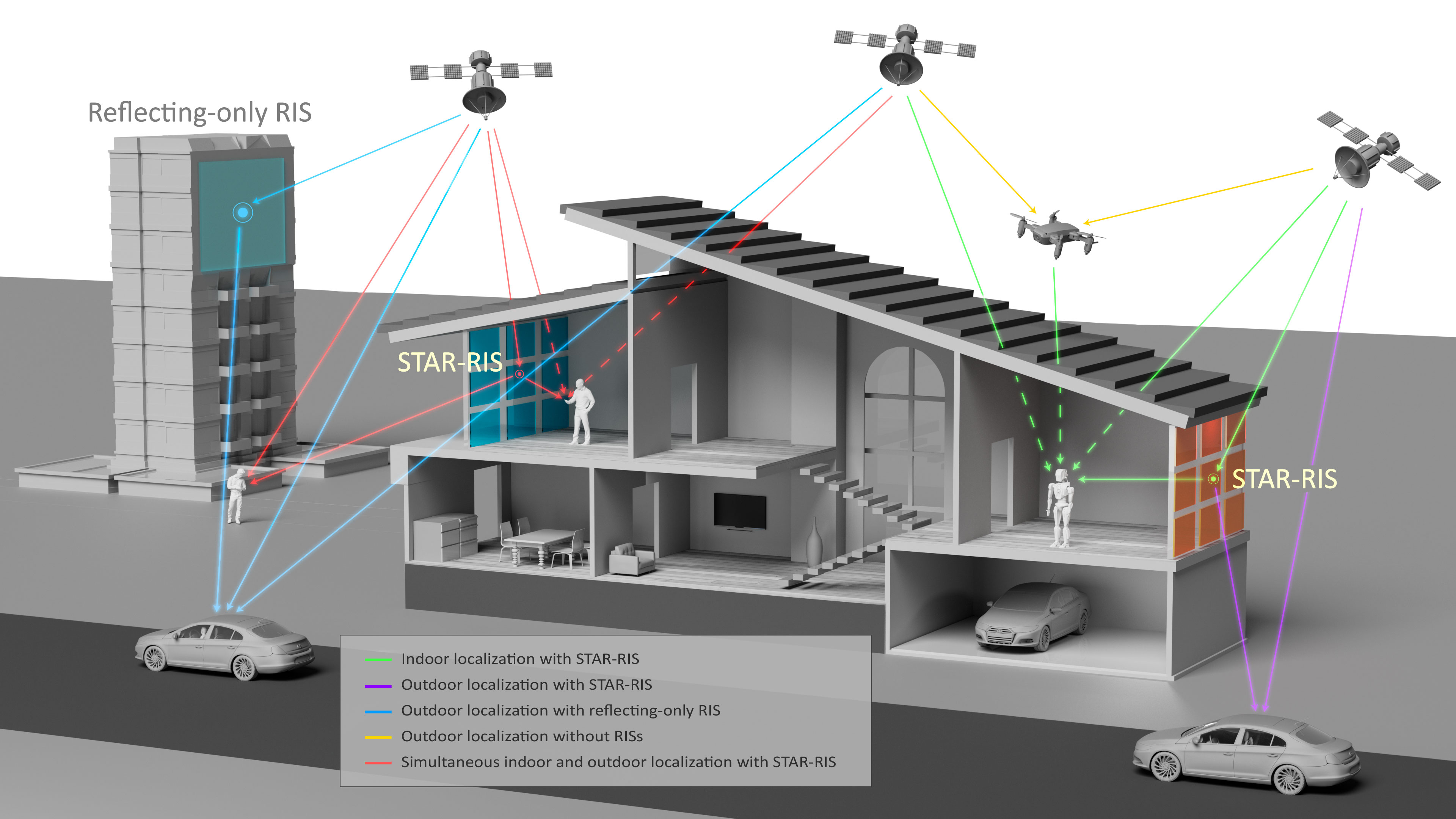
A promising alternative for achieving universal indoor localization is the utilization of low Earth orbit (LEO) satellites. LEO satellites operate at altitudes ranging from a few hundred to 2,000 km, enabling faster satellite motion and shorter signal propagation distances compared to MEO and geostationary Earth orbit (GEO) satellites. As a result, LEO satellites yield stronger signal reception capabilities, offering substantial potential for indoor localization [3]. Nonetheless, while LEO satellite signals are receivable by indoor users, they still cannot deliver the required signal strength for achieving high-accuracy indoor localization. This limitation arises from the fact that LEO satellites face challenges similar to those encountered by GNSS. Namely, satellite signals always undergo significant degradation within urban regions due to the obstructive, weakening, reflective, and diffractive effects of surrounding buildings [4]. To overcome these inherent challenges, reconfigurable intelligent surfaces (RISs) emerge as a powerful solution. As critical enablers of future smart radio environments, RISs are expected to find wide deployment in urban regions [5, 6]. Through RISs, it is possible to intelligently manipulate wireless channels, ensuring effective and reliable satellite signal reception for ground users. In particular, active RISs can strengthen weak satellite signals, and simultaneously transmitting and reflecting RISs (STAR-RISs) can act as bridges connecting indoor and outdoor environments [7], further enhancing signal reception and thus improving localization performance. Therefore, the collaborative utilization of LEO satellites and RISs holds the potential to provide a universal indoor and outdoor localization service. Fig. 1 illustrates a conceptual diagram showcasing the integration of LEO satellites and RISs providing seamless indoor and outdoor localization services.
This article presents a feasibility study exploring the utilization of LEO satellites and RISs for achieving seamless indoor and outdoor localization. We begin by introducing the individual features and recent advances of LEO satellites and RISs. Subsequently, we discuss their potential for a systematic integration. To reveal the potential of the proposed system, several case studies are conducted, which evaluate the position error bounds (PEBs) for RIS-aided localization based on LEO satellite signals. Finally, several open challenges and future research directions are discussed, followed by the conclusion of this work.
II LEO Satellite
The concept of LEO satellites is not novel, with the first one launched as early as 1957. By the 1980s, the potential for narrowband communications using LEO satellites was being explored. However, the high costs associated with them prevented their widespread adoption. With the advancement of launch vehicles, small satellites, and space technologies over the past few decades, the costs of LEO satellites have dropped dramatically. This has driven the recent surge in the popularity and deployment of LEO satellites.
II-A LEO Satellite Features
Table I provides an overview of selected satellite constellations in LEO, MEO, and GEO. A comparison of satellite features across these orbits can be found in Fig. 2, highlighting the benefits of LEO satellites in terms of launch cost, latency, data throughput, and maneuverability. As indicated in Table I, LEO constellations are designed to cater to a range of services, including PNT, broadband Internet, voice and data service, Internet of Things (IoT), machine-to-machine (M2M) communications, and remote sensing.
While many current and upcoming LEO constellations are not specifically designed for localization services, they possess considerable potential for such applications, attributable to:
-
•
Strong signal power: LEO satellites are considerably closer to Earth compared to MEO and GEO satellites, leading to a notable reduction in path loss and, in turn, significantly enhancing the strength of the received signal [3]. Furthermore, compared with GNSS, LEO communication satellites might employ higher transmission power and more directional beams for high data rates, ensuring that users receive a stronger signal. The strong signal power of LEO satellites bolsters their resistance to interference, jamming, and spoofing attacks.
-
•
Large constellations: Nowadays, thousands of satellites have already been deployed to LEO, with tens of thousands more anticipated to be launched in the near future. LEO constellations reach up to hundreds or thousands of times more satellites than those in MEO and GEO, providing superior visibility and capacity.
-
•
High Doppler shifts: LEO satellites orbit the Earth more rapidly than their GEO and MEO counterparts, resulting in fast changes in their relative position to users. This dynamic movement enables Doppler frequencies to be valuable measurements for precise localization.
-
•
Signal diversity: LEO satellites broadcast signals across diverse frequency bands, employing modulation techniques such as orthogonal frequency-division multiplexing (OFDM), quadrature phase shift keying (QPSK), differential phase shift keying (DPSK), and chirp spread spectrum (CSS). Given their varying directions and altitudes, these satellites offer a rich diversity in their signal profiles.
| Regime | Constellation | Orbital height | Quantity | Bands | Modulation | Services |
| GEO | Intelsat | 35,786 km | 52 | C, Ku, Ka | ||
| Eutelsat | 35,786 km | 36 | C, Ku, Ka | |||
| Arabsat | 35,786 km | 8 | C, Ku, Ka | |||
| MEO | GPS | 20,180 km | 31 | L | BPSK, BOC | PNT |
| GLONASS | 19,130 km | 24 | L | BPSK | PNT | |
| Galileo | 23,220 km | 30 | L | BOC, CBOC | PNT | |
| BeiDou | 21,530 km | L | QPSK, BOC | PNT | ||
| LEO | Xona | 525 km | 258 | L, C | - | PNT |
| Ku, Ka, V | OFDM | Broadband Internet | ||||
| OneWeb | 1,200 km | 648 | Ku | OFDM | Broadband Internet | |
| Ku, Ka | - | Broadband Internet | ||||
| Hongyan | 1,100 1,175 km | 320 | Ka | - | Broadband Internet | |
| Kuiper | 3,236 | Ka | - | Broadband Internet | ||
| Globalstar | 1,414 km | 48 | S, L | OQPSK | Voice and data services | |
| VHF | SDPSK | IoT & M2M communications | ||||
| Iridium NEXT | 781 km | 66 | L, Ka | QPSK | ||
| Dove & SkySat (Planet) | 194 | Multispectral | - | Earth observation | ||
| ICEYE | 560 580 km | 27 | X | - | Earth observation | |
II-B LEO Satellite-Based Localization
Within the last few years, LEO satellites’ potential in localization has been investigated [8], with two categories of methods developed:
-
•
Localization based on dedicated LEO constellations: Dedicated LEO satellites are being developed for PNT services, either as a supplement or alternative to GNSS. These new systems will in principle allow for simple receiver architectures and navigation algorithms. For instance, Xona Space Systems intends to deploy 258 LEO satellites, with one testing satellite already launched, aiming to deliver PNT services with accuracy surpassing GNSS by more than tenfold. However, a drawback of depending solely on these dedicated LEO satellites is the missed opportunity to leverage the rich ambient signals from other LEO constellations.
-
•
Signals of opportunity (SoOp) methods: The LEO satellite signals, which are originally intended for other tasks, can be adaptively repurposed for localization in an opportunistic manner. Based on basic knowledge or characteristics of LEO satellite signals, it is possible to extract measurements such as angle of arrival (AoA), received signal strength (RSS), pseudo-range, carrier phase, and Doppler shifts. These measurements are crucial in determining a user’s position. A notable benefit of these SoOp methods is their ability to tap into a plethora of satellite resources and make use of high signal diversity, with no need for specific positioning signals and dedicated LEO satellites.
II-C Challenges and Opportunities
Although LEO satellites are promising for paving the way for a new era of radio localization, several challenges must be addressed first. Many LEO satellites were not originally designed for such tasks, necessitating advanced signal processing and localization algorithms to interpret their signals effectively. While some LEO constellations, such as Orbcomm, have built-in GNSS receivers and broadcast their GNSS data to users, for others, their orbits are often determined by the two-line element (TLE) files that are produced daily by the North American Aerospace Defense Command (NORAD) [9], which can yield satellite position errors of 2-3 km. Such inaccuracies can compromise precise localization. Furthermore, not all LEO satellites are equipped with stable atomic clocks so their synchronization might not meet the stringent requirements for high-accuracy localization.
As illustrated in Table I, a vast deployment of tens of thousands of LEO satellites is in place to meet the demands for broadband Internet and communication services. These satellites primarily employ the Ku/Ka frequency bands, which dovetail with the frequencies designated for fifth-generation (5G) terrestrial networks. Beyond addressing the increasing demands for data and communication in our contemporary society, 5G technology enables localization capabilities as a revolutionary feature of wireless communication systems [2]. Extensive research into 5G terrestrial localization showcases both impressive accuracy and vast application potential. Inspired by the advancements in 5G terrestrial localization, investigating the potential of integrating LEO satellites with terrestrial systems to enable global, uninterrupted indoor and outdoor localization presents a highly promising and compelling research direction.
III Reconfigurable Intelligent Surface
Emerging as a transformative technology, RISs have their historical roots dating back to the 1960s, with the precursor known as the reflectarray antenna [10]. Over the previous decades, these early studies have paved the way for the development of the modern RIS. Driven by the ever-increasing demand for the intelligent control of radio propagation environments in contemporary wireless systems, the RIS technology has attracted great attention from both industry and academia. The RIS may possess a multitude of structures, e.g., uniform planar array (UPA), uniform circular array (UCA), volumetric array, and conformal arrays. Each RIS radiating element can be digitally controlled and programmed by the usage of positive-intrinsic-negative (PIN) diodes and the change of bias voltage. Besides, there are several technologies to implement RISs, such as varactor diodes, liquid crystal, and leaky-wave antennas. For passive RISs, power-hungry radio frequency (RF) chains (composed of mixture, up and down converter, analog-to-digital converter (ADC), digital-to-analog converter (DAC), power amplifiers) are usually not introduced.
III-A RIS Features
Unlike adapting the transmissions to the time-varying wireless channels, currently we can alter the propagation channels with the help of RISs as to enhance the channel capabilities, thus boosting the communication, localization, and sensing performance. In other words, RISs enable a revolutionary paradigm shift from conventional uncontrolled channels to intelligently controlled ones. The RIS, composed of massive low-cost, energy-efficient, and densely-packed radiating scattering elements, is capable of multi-functionalities, just to name a few, e.g., reflection, beam-focusing, refraction, beam-splitting, absorption, etc. By exploiting these functionalities, inter-user interference can be mitigated, thus improving network throughput and extending the communication range. In addition to communication purposes, when integrated into the existing cellular localization systems, an RIS, either passive or active, can serve as a positioning reference point similar to a base station (BS). Benefiting from its massive number of radiating elements, enhanced spatial resolution and precision can be achieved for the estimation of angular parameters, e.g., AoA and angle of departure (AoD) at the RIS. Meanwhile, it can further increase the robustness and guarantee the continuity of the positioning services, especially in high frequencies, e.g., millimeter wave (mmWave) and Terahertz (THz), where the line-of-sight (LoS) blockage occurs between the BS and user equipment (UE) frequently. As a strong enabler, the RIS makes the single-anchor positioning possible even in the single-input single-output (SISO) setup thanks to the angular measurement introduced by the RIS.
The roles of the RIS in localization are summarized in the following:
-
•
Helper: The RIS can be regarded as an additional anchor; the RIS offers high-precision and high-resolution angular parameters estimation; the RIS is helpful for anti-blockage in mmWave/THz communications and localization.
-
•
Enabler: The RIS enables localization in some extreme or novel scenarios. For instance, single-anchor SISO positioning can be realized with the aid of RISs; the recently proposed STAR-RIS enables simultaneous indoor and outdoor localization [7], which is not feasible for conventional passive RISs.
-
•
Universalist: The RIS can be integrated into various localization systems, e.g., ultra-wideband (UWB), satellite-based, radio cellular, and Bluetooth low energy (BLE) positioning systems.
-
•
Booster: All in all, the RIS can significantly enhance the localization performance in various wireless systems based on the above three roles.
III-B Active RIS vs. STAR-RIS
In addition to the classical passive RIS, this paper places particular emphasis on two types of RIS: the active RIS and the STAR-RIS. These two types take center stage due to their distinctive attributes that can be leveraged to effectively strengthen the connection between satellites and indoor users and thus enable indoor localization, which will be specified in Section IV-A. The conceptual representations of the active RIS and the STAR-RIS are shown in Fig. 3.
As depicted in Fig. 3-(a), with the integration of active reflection-type amplifiers, active RISs can broaden their functionalities beyond shifting the phase of the incident signals to include signal amplification, thereby mitigating the so-called “multiplicative fading” effect [5]. The utilization of active RISs facilitates a remarkable enhancement in controllable non-line-of-sight (NLoS) signal propagation, particularly in the far-field regions. This advantage extends beyond communication, as active RIS technology also holds promise for improving localization performance. Remarkably, although with an introduction of additional noise, the supplementary power gain from active RISs can still offer a significant boost in localization performance when compared to passive RISs, as demonstrated in [11].
Since the reflecting-only RIS (including both active and passive types) only has a half-space coverage, the STAR-RIS has been proposed to obtain a full-space coverage [6], as depicted in Fig. 3-(b). The STAR-RIS is integrated with multiple functionalities, e.g., refraction (a.k.a. transmission) and reflection, providing a bridge between indoor and outdoor connectivity. In this sense, an outdoor BS can offer extended coverage for indoor users while maintaining outdoor coverage with the aid of a STAR-RIS [7, 6]. By following this principle, the STAR-RIS can be a technological enabler for simultaneous indoor and outdoor localization. With the introduction of energy splitting between the two different modes, the quality of service (QoS) requirements of the indoor and outdoor users can be concurrently satisfied [7]. The two functionalities can be operated in multiple ways, e.g., time division duplex (TDD), energy splitting, etc, depending on the QoS requirements of the users. However, the STAR-RIS introduces increased hardware complexity and operational cost compared to the reflecting-only RISs.
IV Integrated Indoor and Outdoor Localization
Given the potential of LEO satellites to deliver strong signals within indoor settings and the remarkable capability of the RIS to reconfigure signal propagation paths thereby improving localization performance, the fusion of LEO satellites and RISs emerges as a highly promising paradigm for future localization systems. In this section, we first discuss the feasibility of achieving seamless indoor and outdoor localization via the synergistic incorporation of LEO satellites and RISs. Subsequently, we present case studies that reveal the potential of this integrated localization system and use the Cramér-Rao lower bound (CRLB) to evaluate the localization performance.
IV-A The Synergy between LEO Satellites and RISs
In addition to their individual potential as groundbreaking technologies for 6G and beyond, the synergy between LEO satellites and RISs for localization purposes can be substantiated by the following three compelling factors:
-
•
Frequency alignment: LEO satellites and RISs operate within overlapping frequency bands. As presented in Table I, most LEO satellites work in the Ku (12–18 GHz) and Ka (26–40 GHz) bands, which are closely aligned with the frequency bands where RISs are designed to function. According to the experimental results in the literature, RISs can operate in the frequencies varying from sub-6 GHz to 5G mmWave n257 and n258 bands (i.e., from 24.25 to 29.5 GHz) [12]. This convergence in frequency bands implies a trend that LEO satellites and ground-based 5G/6G infrastructure are moving towards harmonization, paving the way for future seamless air-ground integration.
-
•
Path loss mitigation: LEO satellite signals contend with severe path loss due to factors such as long-distance propagation attenuation, atmospheric absorption, outdoor-to-indoor penetration losses, etc. While LEO satellites operating in the Ku band exhibit higher power reception compared to MEO satellites operating in the L band (up to 5 dB in the indoor environment and 18 dB in the outdoor environment [3]), the received signal strength indoors still remains insufficient for precise user localization. Herein, an active RIS capable of amplifying reflected/refracted signals emerges as a promising solution to mitigate this inherent limitation [5]. Meanwhile, the STAR-RIS can act as a bridge linking indoor and outdoor connectivity, making seamless indoor and outdoor localization possible.
-
•
Resource abundance: Both LEO satellites and RISs have already been or will be extensively deployed in the foreseeable future, thus reinforcing their suitability for cooperative deployment. Notably, the distinctive characteristics of LEO satellites and RISs can synergistically enhance each other. In rural environments where RISs and 5G/6G BSs are typically absent, a vast constellation of LEO satellites numbering in the tens of thousands can furnish reliable localization coverage to ground users. Conversely, in densely urbanized areas with obstructive buildings, the ubiquitous deployment of RISs can effectively enhance the reception of LEO satellite signals.
-
•
Localization and communication integration: In addition to enhancing localization capabilities, the aforementioned features can also yield substantial advantages for wireless communications. On one hand, precise localization plays an essential role in facilitating high-speed and reliable mmWave/THz communications, a requirement underscored by industry standards such as 3GPP [1]. On the other hand, even in scenarios lacking location information, the cooperative integration of LEO satellites and RISs can still offer improved communication performance, owing to their attributes of broadband high-speed connectivity, global coverage, and low-latency signal propagation. This promising convergence of LEO satellites and RISs represents a potential avenue toward the realization of space-air-ground localization and communication integration in the near future.
IV-B Localization Case Studies
This subsection evaluates the localization performance of wireless systems empowered by the collaboration of LEO satellites and RISs, across both indoor and outdoor environments. As an evaluation metric for localization performance, the CRLB is derived to provide a PEB. In our simulation setup, we situate all LEO satellites at the same altitude of 600 km, with the orbits being generated by the QuaDRiGa simulator [13]. Each LEO satellite is assumed to be equipped with an array of isotropic antennas with a half-wavelength spacing. Both the LEO satellite antenna array and the RIS employ random beamforming designs. The transmit power of each LEO satellite is set to 55 dBm. We consider downlink transmissions using OFDM signals with 3,000 subcarriers and 5 transmissions, operating at a carrier frequency of 12.7 GHz in the Ku band with a bandwidth of 240 MHz. For outdoor scenarios, we incorporate a path loss model that accounts for the free space path loss and atmospheric absorption [13]. While in indoor settings, we further incorporate the outdoor-to-indoor penetration loss, based on the empirical results in [14]. The derived CRLB evaluates the error bound in the estimation process of the user’s position relying on received signals. The adopted channel parameters (or observables) encompass AoDs from both LEO satellites and RISs, time delays from both LEO and RIS signals, and Doppler frequency shifts associated with LoS signals from LEO satellites to the user.
IV-B1 PEB vs. Number of Satellites
Fig. 4 presents the PEB evaluation vs. the number of LEO satellites for both indoor and outdoor scenarios. The positions of LEO satellites are randomly selected from various 600 km orbits generated by the QuaDRiGa simulator. In this evaluation, two active STAR-RISs (a joint design of active RIS and STAR-RIS from Fig. 3), each featuring a element configuration and with -30 dBm power supply, are employed. Each STAR-RIS is characterized by a reflection coefficient , indicating the proportion of power that is reflected. Specifically, when a unit power signal is incident, the power of the reflected signal is given by , while the power of the refracted signal is determined as , as illustrated in Fig. 3. Throughout all the tested scenarios, the distance between the user and each RIS is fixed as 15 m.
As shown in Fig. 4, an increase in the number of LEO satellites is generally associated with a reduction in PEB, indicating a more accurate localization performance. It is observed that without the incorporation of RISs, standalone LEO satellite-based indoor localization exhibits an impractically high PEB at the level of 100 m. In contrast, standalone LEO satellite-based localization can achieve meter-level accuracy in outdoor scenarios when a sufficient number of satellites are available (e.g., more than 8). However, the localization performance of both indoor and outdoor scenarios can be significantly improved with the utilization of the active STAR-RISs. In particular, active STAR-RISs can elevate indoor localization accuracy to the meter level, rendering indoor localization services feasible. Furthermore, the choice of the reflection coefficient for STAR-RISs has a notable impact on localization performance. Specifically, increasing improves outdoor localization performance while degrading indoor localization performance, and vice versa. Additionally, the results also indicate that increasing the number of RISs contributes to improving localization accuracy.
IV-B2 PEB vs. User’s Positions
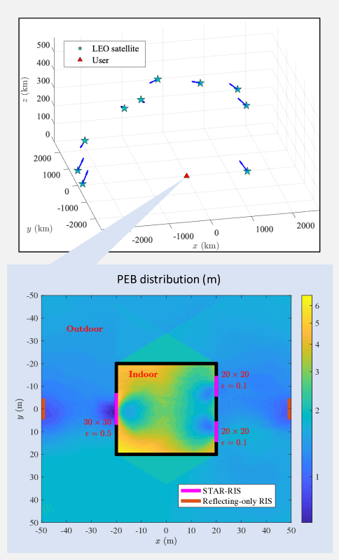
Now we evaluate the localization performance under varying user positions. Fig. 5 provides a graphical representation of the 10 randomly selected satellite positions employed in this simulation, while the zoomed-in subfigure illustrates the evaluation of the PEBs across diverse user locations, encompassing both indoor and outdoor environments within a region. As depicted in Fig. 5, we incorporate a total of 5 RISs, comprising 3 STAR-RISs and 2 reflecting-only RISs, all being active and operating at an identical power supply of -30 dBm. Fig. 5 clearly indicates that areas near RISs exhibit superior localization accuracy. Notably, STAR-RISs enable indoor localization with meter-level precision. It is observed that the accuracy of indoor localization diminishes in areas far from STAR-RISs, such as in the corners of a room. Nevertheless, indoor regions in proximity to STAR-RISs can achieve significantly more accurate localization, even surpassing the precision of certain outdoor areas. Furthermore, the results in Fig. 5 also demonstrate the influence of the STAR-RIS reflection coefficient . Specifically, higher values of contribute more to outdoor localization performance, whereas lower values of enhance indoor localization accuracy. In summary, the collaboration of LEO satellites and RISs holds substantial potential for delivering seamless localization services, bridging the gap between indoor and outdoor environments.
V Open Problems and Future Directions
While the synergy between LEO satellites and RISs shows significant promise in achieving uninterrupted localization services across indoor and outdoor environments, a number of outstanding challenges warrant attention and investigation. Meanwhile, this convergence of technologies offers a rich landscape of research opportunities for further exploration.
V-A Effective Localization Algorithms
Numerous localization techniques have been developed for the terrestrial localization system (5G/6G wireless system) and the MEO satellite-based localization system (GNSS). However, a noticeable gap persists in the realm of LEO satellite-based localization algorithms. Presently, blind signal reception and estimation are crucial techniques for localization via SoOp methods utilizing LEO satellites. An essential hurdle for further advancements in this area is the pressing need for a precise channel model tailored to LEO satellite signals. Additionally, exploiting inherent attributes of LEO satellite signals offers substantial potential for developing novel and effective localization algorithms. Notable among these attributes include: i) the strong Doppler effect exhibited by LEO satellite signals, which contain location information of the observer; ii) the deployment capability of antenna arrays on LEO satellites, facilitating AoD estimation; iii) the rapid orbital motion of LEO satellites, affording the possibility for a single satellite to provide multiple location references within a short observation duration.
V-B Joint RISs Beamforming Design
In urban environments, the collaborative use of multiple RISs is crucial for achieving specific localization objectives. Nevertheless, the simultaneous reconfiguration of multiple RISs to attain optimal localization performance remains a challenge, as most existing works on localization-oriented RIS beamforming are limited to single RIS setups. For instance, optimizing multiple RISs together would make search-based strategies infeasible due to increased complexity. Furthermore, signals originating from both terrestrial BSs and LEO satellites may impinge on RISs, intensifying the complexity of the problem. Given that RISs may need to handle signals from various transmitters, which may exhibit distinct modulation schemes and propagation distances, the development of multi-timescale beamforming designs becomes imperative in addressing these challenges.
V-C LEO Satellite Constellation Optimization
For LEO satellites, it is a common scenario where numerous satellites are available to a certain user, while only a limited number might be necessary to achieve the effective localization accuracy required for certain applications. As presented in Fig. 4, for instance, achieving meter-level localization accuracy in outdoor environments, even without leveraging RISs, can be attained with 8 satellites. Furthermore, the accuracy of localization is also significantly influenced by the spatial distribution of these satellites. Hence, how to choose the optimal satellite constellation to deliver localization services for a certain user becomes a crucial issue. Typically, the quality of a satellite constellation can be assessed using metrics such as geometric dilution of precision (GDOP). Moreover, multiple users may concurrently request localization services from various locations. As a result, how to allocate satellite resources to different ground users, with the goal of optimizing the overall performance of localization services, remains a critical and unresolved challenge.
V-D Near-Field Challenges
The advent of extremely large-scale RISs has led to an increased presence of near-field users. In the near-field (i.e., close proximity to RIS up to Fraunhofer distance), the spherical electromagnetic wavefronts can no longer be approximated as planar, reshaping the channel model and bringing forth new challenges and opportunities for localization. First, the coupling of range and angle in the spherical wave model allows for direct localization that skips the estimation of intermediate channel parameters, at the expense of higher complexity. Moreover, based on the unique characteristics of spherical wavefronts, novel beam-focusing techniques are being explored in contrast to conventional far-field beamforming. In addition, the near-field channel can also result in spatial non-stationarity and the beam squint effect [15], which merit consideration in research such as algorithm development, beamforming design, satellite constellation optimization, etc.
V-E STAR-RIS Hardware Implementation
Although STAR-RISs have shown significant promise for achieving so-called full-space manipulation of signal propagation, and several theoretical performance assessment works have been reported [6], the hardware realization of STAR-RISs remains blank in the literature. The prospects for the hardware realization of STAR-RIS may stem from the integration of the transmitarray and reflectarray antennas. However, challenges may arise in the effective control of transmitting and reflecting power allocation, the independent reconfiguration of transmitting and reflecting phase shifts, and the mitigation of interference within the feeding network.
VI Conclusion
This article proposes a potential solution that achieves global seamless indoor and outdoor localization by advocating the cooperation of LEO satellites and RISs. With the current and future widespread deployment of LEO satellites and RISs, the possibility and suitability of synergizing these two technologies for enhanced localization services become increasingly apparent. The promise of such a collaborative system is substantiated in this paper through comprehensive feasibility analyses and proof-of-concept simulations. Furthermore, the discussion encompasses key unresolved challenges and research directions within this domain, underscoring the importance of ongoing exploration in this evolving field.
VII Acknowledgments
Fig. 1 was created by Thom Leach, Scientific Illustrator at KAUST.
References
- [1] X. Lin, “An overview of 5G advanced evolution in 3GPP release 18,” IEEE Commun. Standards Mag., vol. 6, no. 3, pp. 77–83, 2022.
- [2] J. A. del Peral-Rosado, R. Raulefs, J. A. López-Salcedo, and G. Seco-Granados, “Survey of cellular mobile radio localization methods: From 1G to 5G,” IEEE Commun. Surv. Tutor., vol. 20, no. 2, pp. 1124–1148, 2018.
- [3] R. M. Ferre, E. S. Lohan, H. Kuusniemi, J. Praks, S. Kaasalainen, C. Pinell, and M. Elsanhoury, “Is LEO-based positioning with mega-constellations the answer for future equal access localization?” IEEE Commun. Mag., vol. 60, no. 6, pp. 40–46, 2022.
- [4] P. Zheng, X. Liu, T. Ballal, and T. Y. Al-Naffouri, “Attitude determination in urban canyons: A synergy between GNSS and 5G observations,” in proc. of the 36th International Technical Meeting of the Satellite Division of The Institute of Navigation (ION GNSS+), 2023, pp. 1928–1941.
- [5] Z. Zhang, L. Dai, X. Chen, C. Liu, F. Yang, R. Schober, and H. V. Poor, “Active RIS vs. passive RIS: Which will prevail in 6G?” IEEE Trans. Commun., vol. 71, no. 3, pp. 1707–1725, 2023.
- [6] M. Ahmed, A. Wahid, S. S. Laique, W. U. Khan, A. Ihsan, F. Xu, S. Chatzinotas, and Z. Han, “A survey on STAR-RIS: Use cases, recent advances, and future research challenges,” IEEE Internet Things J., vol. 10, no. 16, pp. 14 689–14 711, 2023.
- [7] J. He, A. Fakhreddine, and G. C. Alexandropoulos, “STAR-RIS-enabled simultaneous indoor and outdoor 3D localisation: Theoretical analysis and algorithmic design,” IET Signal Process., vol. 17, no. 4, p. e12209, 2023.
- [8] F. S. Prol, R. M. Ferre, Z. Saleem, P. Välisuo, C. Pinell, E. S. Lohan, M. Elsanhoury, M. Elmusrati, S. Islam, K. Çelikbilek, K. Selvan, J. Yliaho, K. Rutledge, A. Ojala, L. Ferranti, J. Praks, M. Z. H. Bhuiyan, S. Kaasalainen, and H. Kuusniemi, “Position, navigation, and timing (PNT) through low Earth orbit (LEO) satellites: A survey on current status, challenges, and opportunities,” IEEE Access, vol. 10, pp. 83 971–84 002, 2022.
- [9] CelesTrak. (2023) NORAD two-line element sets. [Online]. Available: https://www.celestrak.com/NORAD/elements/
- [10] D. Berry, R. Malech, and W. Kennedy, “The reflectarray antenna,” IEEE Trans. Antennas Propagat., vol. 11, no. 6, pp. 645–651, 1963.
- [11] P. Zheng, H. Chen, T. Ballal, M. Valkama, H. Wymeersch, and T. Y. Al-Naffouri, “JrCUP: Joint RIS calibration and user positioning for 6G wireless systems,” IEEE Trans. Wireless Commun. (early access), 2023.
- [12] R. Wang, Y. Yang, B. Makki, and A. Shamim, “A wideband reconfigurable intelligent surface for 5G millimeter-wave applications,” arXiv preprint arXiv:2304.11572, 2023.
- [13] F. Burkhardt, S. Jaeckel, E. Eberlein, and R. Prieto-Cerdeira, “QuaDRiGa: A MIMO channel model for land mobile satellite,” in proc. of the 8th European Conference on Antennas and Propagation (EuCAP), 2014, pp. 1274–1278.
- [14] I. Rodriguez, H. C. Nguyen, I. Z. Kovács, T. B. Sørensen, and P. Mogensen, “An empirical outdoor-to-indoor path loss model from below 6 GHz to cm-Wave frequency bands,” IEEE Antennas Wireless Propagat. Lett., vol. 16, pp. 1329–1332, 2017.
- [15] H. Chen, M. F. Keskin, A. Sakhnini, N. Decarli, S. Pollin, D. Dardari, and H. Wymeersch, “6G localization and sensing in the near field: Fundamentals, opportunities, and challenges,” arXiv preprint arXiv:2308.15799, 2023.
| Pinjun Zheng (pinjun.zheng@kaust.edu.sa) is a PhD student in the Electrical and Computer Engineering Program, CEMSE, King Abdullah University of Science and Technology (KAUST), Thuwal, 23955-6900, Kingdom of Saudi Arabia. His research interests include mmWave/THz localization and communication. |
| Xing Liu (xing.liu@kaust.edu.sa) is a postdoctoral researcher in the Electrical and Computer Engineering Program, CEMSE, King Abdullah University of Science and Technology (KAUST), Thuwal, 23955-6900, Kingdom of Saudi Arabia. His current research focuses on precise GNSS positioning and attitude determination. |
| Jiguang He (jiguang.he@tii.ae) is a senior researcher at the Technology Innovation Institute, Masdar City, United Arab Emirates. His research interests span millimeter wave MIMO communications, reconfigurable intelligent surfaces for simultaneous localization and communication (SLAC), and advanced signal processing techniques. |
| Gonzalo Seco-Granados (gonzalo.seco@uab.cat) is a professor with the Department of Telecommunication, Universitat Autònoma de Barcelona, Bellaterra, Spain. His research interests include GNSS, and beyond 5G integrated communications, localization, and sensing. |
| Tareq Y. Al-Naffouri (tareq.alnaffouri@kaust.edu.sa) is a professor in the Electrical and Computer Engineering Program, CEMSE, King Abdullah University of Science and Technology (KAUST), Thuwal, 23955-6900, Kingdom of Saudi Arabia. His current research focuses on the areas of sparse, adaptive, and statistical signal processing and their applications, as well as machine learning and network information theory. |