Survey on Near-Space Information Networks: Channel Modeling, Networking, and Transmission Perspectives
Abstract
Near-space information networks (NSIN) composed of high-altitude platforms (HAPs), high- and low-altitude unmanned aerial vehicles (UAVs) are a new regime for providing quickly, robustly, and cost-efficiently sensing and communication services. Precipitated by innovations and breakthroughs in manufacturing, materials, communications, electronics, and control technologies, NSIN have emerged as an essential component of the emerging sixth-generation of mobile communication systems. This article aims at presenting some critical issues and design proposals in our actual NSIN and discussing the latest advances in NSIN in the research areas of channel modeling, networking, and transmission from a forward-looking, comparative, and technological evolutionary perspective. In this article, we highlight the characteristics of NSIN and present the promising use-cases of NSIN. The impact of airborne platforms’ unstable movements on the phase delays of onboard antenna arrays with diverse structures is mathematically analyzed. The recent advancements in HAP channel modeling are elaborated on, along with the significant differences between HAP and UAV channel modeling. A comprehensive review of the networking technologies of NSIN in network deployment, handoff management, and network management aspects is provided. Besides, the promising technologies and communication protocols of the physical (PHY) layer, medium access control (MAC) layer, network layer, and transport layer of NSINs for achieving efficient transmission over NSINs are overviewed, and we have conducted experiments with our actual NSIN to verify the performance of some techniques. Finally, we outline some open issues and promising directions of NSINs deserved for future study and discuss the corresponding challenges.
Index Terms:
High-altitude platforms, unmanned aerial vehicles, channel modeling, network deployment, handoff management, network management, efficient transmissionI Introduction
Recent advances in manufacturing, materials, communications, electronics, and control technologies have witnessed an unprecedented increase in the application of various types of non-terrestrial platforms in the military and civil fields. In the wireless communication research field, non-terrestrial networks (NTN) have been included as a part of the Third Generation Partnership Project (3GPP) Rel-17 specifications, and discussions of NTN are scheduled in the 3GPP Rel-18 work plan to support the fifth-generation of mobile communication systems (5G) advanced use cases [1]. Additionally, the integration networks of NTN and terrestrial networks (TN) (or space-air-ground networks), the architecture of which is shown in Fig. 1, have been globally considered a promising proposal for the emerging sixth-generation of mobile communication systems (6G) [2].
As a crucial component of NTN, near-space information networks (NSIN) are a new regime of situational awareness, processing, and serving networks composed of high-altitude platforms (HAPs, including aircraft, airships, and balloons), high-altitude unmanned aerial vehicles (HAUAVs), and low-altitude unmanned aerial vehicles (LAUAVs). Compared with traditional space networks, NSIN have some unique advantages in terms of deployment flexibility and agility, deployment and operation cost, responsiveness, transmission latency, and responsiveness. HAPs in NSIN, deployed at an altitude ranging from 17 km to 25 km, have the ability to extend the communication coverage quickly and provide wide-area communication services. The unmanned aerial vehicles (UAVs) in NSIN, deployed at a relatively low altitude ranging from several meters to thousands of meters, can achieve service enhancements in critical areas. Further, NSIN overwhelm TN in terms of quick response to flash crowd traffic, providing coverage in unserved or underserved areas cost-effectively, and being resilient to natural and man-made disasters. Summarily, NSIN have some outstanding advantages in achieving wide-area and three-dimensional (3-D) coverage as well as local on-demand service enhancement.
As a result, NSIN have become an essential segment of space-air-ground networks and have wide application prospects in fields such as regional surveillance, emergency communication, intelligent transportation systems (ITS), and computational offloading. Although NSIN have many attractive advantages and application prospects, there are many key issues, such as channel modeling, networking, and transmission, waiting to be solved before NSIN can seamlessly integrate with space networks and TN and really contribute to the emerging 6G technological standards.
I-A Surveys and Reviews on NSIN in Recent Ten Years
During the past ten years, the research on NSIN has attracted extensive attention from both academia and industry. In this subsection, we overview the surveys and reviews on NSIN in the recent ten years, and the reader is recommended to refer to these articles and the references therein for more detailed information on NSIN111It is noteworthy that a number of excellent surveys and reviews on space-air-ground integrated networks have been published. Nevertheless, we do not aim to discuss the state-of-the-art in the research field of space-air-ground integrated networks. Actually, HAP networks and UAV networks are not separately considered in the above works. Besides, few of them differentiate UAVs from HAPs and discuss the optimization and management method design with aerial platform heterogeneity consideration. We therefore do not review and compare with them in this article..
A review of using HAPs for wireless communications in rural communities was conducted in [3]. The authors reviewed HAP resource and interference management techniques, where the potential of utilizing radio environment maps and artificial intelligence (AI) for HAP interference and resource management was discussed. Some coverage extension methods were also summarized in this review. The authors in [4] summarized the recent progress of HAPs concerning aspects of shape optimization, thermal analysis, and design studies. Particularly, they discussed various thermal investigations and numerical modeling approaches to study HAP thermal performance, studied aerodynamic shape optimization and solar array layout optimization methods, and analyzed many HAP design optimization methods with and without thermal consideration. In [5], a review of the evolution of HAP projects and HAP technologies in the aeronautical engineering field rather than the telecommunications area was conducted. The work in [6] surveyed HAP-enabled communication systems from the perspectives of channel modeling, performance analysis of HAP systems, and energy and interference management methods. The work in [7] presented a comprehensive literature review of channel modeling, radio resource management, interference management, waveform design, handoff management, and network management in HAP networks of the future. Besides, the HAP communication system and two HAP onboard subsystems, i.e., energy management and communication payload subsystems, were elaborated on in this work. The authors in [8] gave a comprehensive review of enabling the connectivity applications of HAP and UAV platforms utilizing current and future communication technologies, including direct air-to-ground communications, HAP communications, air-to-air communications, and multi-link heterogeneous communications. The network architectures for airplanes and UAVs from the literature were analyzed. Besides, an up-to-date list of open-source simulator & emulator platforms for airplanes and UAVs was provided. In the paper [9], the authors provided a comprehensive review and discussion of AI-driven NSIN research, considering both communication and computation perspectives. The authors in [10] discussed the existing spectrum sharing techniques of UAV and HAP networks in detail from the perspectives of spectrum utilization rules, spectrum sharing modes, spectrum sensing, and interference management technologies. The work in [11] comprehensively reviewed low-altitude platform (LAP)-based communication networks, HAP-based communication networks, and integrated airborne communication networks. This work discussed the design of LAP-based communication networks from movement control, networking, and transmission perspectives. It also elaborated on the channel modeling of HAP-based communication networks and shed light on how to implement integrated airborne communication networks. Different from the above works, this survey will explicitly distinguish HAPs and UAVs, highlight the design considerations of NSIN, and comprehensively review the research on channel modeling, networking, and transmission of NSIN. The comparison of this article with the existing surveys & reviews on NSIN in recent ten years is presented in Table I.
| Refs. |
|
|
Networking | Transmission | Main concerns/contributions | ||||||||||||
| [3] |
|
|
Cover |
|
|
||||||||||||
| [4] |
|
||||||||||||||||
| [5] |
|
||||||||||||||||
| [6] | Partial |
|
|
||||||||||||||
| [7] |
|
|
Overview |
|
|
||||||||||||
| [8] |
|
|
|
||||||||||||||
| [9] |
|
A brief review on AI-driven aerial access networks. | |||||||||||||||
| [10] |
|
|
|||||||||||||||
| [11] |
|
|
|
|
|
||||||||||||
|
✓ | ✓ | ✓ | ✓ |
|
I-B Contributions and Organization
The goal of this article is to present an overview of the research on NSIN in the literature in recent ten years. Although NSIN achieve a series of technological innovations and major breakthroughs in the research fields of seamless communications, wide-area sensing, ubiquitous computing, and flexible control, this article mainly surveys and discusses the latest advancements of NSIN in channel modeling, networking, and transmission aspects. The main contributions are as follows:
-
•
Presenting some critical issues encountered in the design and application of our actual NSIN and some design proposals.
-
•
Characterizing the NSIN and introducing the NSIN as a promising, responsive, and cost-effective solution for wide-area coverage services and local-area service enhancement. We highlight the differences between HAP and UAV from the diverse perspectives of mobility model, energy sources and endurance, payload and power capability, and footprint.
-
•
Introducing the design consideration of NSIN and discussing the impact of heterogeneity of airborne platforms in the protocol design and resource allocation of NSIN. The cooperation among heterogeneous airborne platforms is also advocated.
-
•
Elaborating on the size (or space), weight, mobility, and power (SWMAP) constraints of airborne platforms in NSIN. Introducing the concept of the situation (information) of NSIN and discussing the significance of the network and security situation in the design of NSIN.
-
•
Discussing the impact of the unstable movements of airborne platforms on the phase delays of diverse types of onboard antenna arrays. We present the components of a typical channel model of a HAP-ground channel and discuss the corresponding large-scale fading and small-scale fading in detail. At the same time, we provide a comprehensive review of HAP channel modeling in the recent literature and reveal the significant differences between HAP and UAV channel models.
-
•
Overviewing and discussing the networking approaches of NSIN in the literature. This includes an extensive discussion of how to deploy NSIN to satisfy the quality-of-service (QoS) and quality-of-experience (QoE) requirements of service recipients. A plethora of handoff strategies taking into account serving user-side handoff metrics, airborne platform-side handoff metrics, security, and surveillance information are presented. Network management techniques from the technical perspectives of link fault recovery, airborne platform coordination, and network architecture redefinition are also discussed.
-
•
Discussing how to achieve efficient transmission in NSIN from an extensive perspective of designing transmission approaches and protocols at the physical (PHY) layer, the medium access control (MAC) layer, the network layer, as well as the transport layer of NSIN.
-
•
Introducing the integration of reconfigurable intelligent surfaces (RIS) or intelligent reflecting surfaces (IRS) with airborne platforms in NSIN and presenting the benefits of such integration. The feasibility of applying three types of MAC protocols, including the fixed allocation protocol, the random contention protocol, and the reservation protocol, to NSIN in accordance with the characteristics of NSIN is discussed. We highlight the distinction between UAV routing protocols and routing protocols of NSIN, and present the evolution of NSIN routing protocols from a HAP-assisted design to a unified design. Presenting the challenges of applying a conventional transport control protocol (TCP) to NSIN and providing an overview of the transport layer protocols customized for NSIN. The main ideas, pros, and cons of these protocols are also summarized.
-
•
We also conduct experiments with our actual NSINs to quantify the effects of certain interfering factors and verify the feasibility of some techniques.
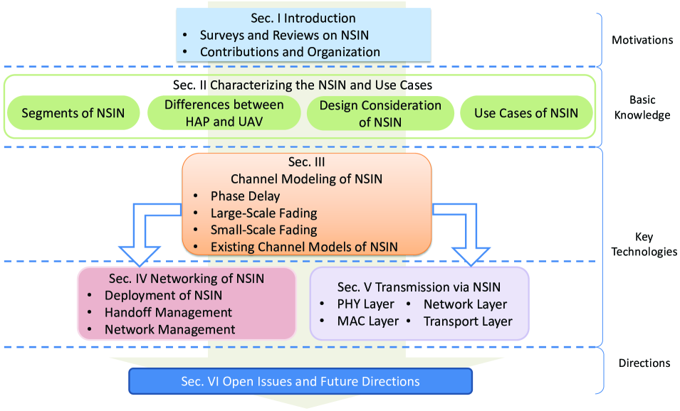
Finally, we conclude by summarizing the open issues and promising directions for future study. We illustrate the outline of this article in Fig. 2. Specifically, in Section II, we characterize the NSIN in detail and present the promising use cases of NSIN that aim to enable the reader to deepen their knowledge and understanding of NSIN. In Section III, we elaborate on the components of the channel models of NSIN while highlighting the impact of unstable platform movement and meteorological factors on the channel modeling of NSIN. Section IV describes key issues in the networking of NSIN, including network deployment, handoff management, and network management. The objectives, solutions, and key technologies of networking in NSIN are summarized and discussed in detail. In Section V, we comprehensively present the key technologies at the PHY layer, MAC layer, network layer, and transport layer of NSIN for achieving effective transmission. The main ideas and performance of these technologies are discussed and compared. In Section VI, some open issues that need to be tackled and future directions that deserve attention are presented. Finally, we conclude this article in Section VII. For ease of reading, some significant acronyms in this article are shown in Table II.
| Acronyms | Description | Acronyms | Description | ||||
|---|---|---|---|---|---|---|---|
| 3GGP | Third Generation Partnership Project | A-GR | ADS-B system aided Geographic Routing | ||||
| 5G |
|
6G |
|
||||
| ACO | Ant Colony Optimization | ADC | Analog-to-Digital Converter | ||||
| ADS-B | Automatic Dependent Surveillance-Broadcast | AI | Artificial Intelligence | ||||
| ALOHA | Additive Links On-line Hawaii Area | AoA/AoD | Angle of Arrival/ Angle of Departure | ||||
| ARIS | Aerial-RIS | ATM | Air Traffic Management | ||||
| B5G | Beyond 5G | CDMA | Code Division Multiple Access | ||||
| CDN | Content Delivery Networks | XR | Extended-Range | ||||
| CIR | Carrier-to-Interference Ratio | CNPC | Control and Nonpayload Communication | ||||
| CSMA/CA |
|
CTS | Clear to Send | ||||
| DAC | Digital-to-Analog Converter | DC | Direct Current | ||||
| DLR | Deutsches Zentrum für Luft- und Raumfahrt | DoA | Direction of Arrival | ||||
| DQN | Deep Q-Network | DRL | Deep Reinforcement Learning | ||||
| DTN | Delay Tolerant Networks | E2E | End-to-End | ||||
| EM | Electromagnetic | FDMA | Frequency Division Multiple Access | ||||
| FSO | Free Space Optical | FSPL | Free Space Path Loss | ||||
| FWA | Fixed Wireless Access | GM | Gauss-Markov | ||||
| GPS | Global Positioning System | HAPs | High-Altitude Platforms | ||||
| URLLC |
|
HGHR |
|
||||
| IFT | Instantaneous Flight Time | IMT | International Mobile Telecommunications | ||||
| IoT | Internet of Things | IRS | Intelligent Reflecting Surface | ||||
| ISI | Inter-Symbol Interference | ISR | Intelligence, Surveillance, and Reconnaissance | ||||
| ITS | Intelligent Transportation Systems | ITU | International Telecommunication Union | ||||
| LAP | Low-Altitude Platform | LAUAVs | Low-Altitude Unmanned Aerial Vehicles | ||||
| LMS | Least Mean Square | LSTM | Long Short-Term Memory Network | ||||
| LTE | Long Term Evolution | MANET | Mobile Ad hoc Network | ||||
| MIMO | Multiple-Input Multiple-Output | ML | Machine Learning | ||||
| MOS | Mean Opinion Score | MPB | Mission Plan Based | ||||
| NFV | Network Function Virtualization | NLoS | Non-Line-of-Sight | ||||
| NOMA | Non-Orthogonal Multiple Access | NSIN | Near-Space Information Networks | ||||
| NTN | Non-Terrestrial Networks | OFDM | Orthogonal Frequency Division Multiplexing | ||||
| PAC | Proxy Authentication Center | PDR | Packet Delivery Ratio | ||||
| PNT | Positioning, Navigation, and Timing | PR | Pheromone Repel | ||||
| PSNR | Peak Signal-to-Noise Rate | QoE | Quality-of-Experience | ||||
| QoS | Quality-of-Service | RF | Radio-Frequency | ||||
| RIS | Reconfigurable Intelligent Surface | RL | Reinforcement Learning | ||||
| RM | Random Movements | RMS | Root Mean Square | ||||
| RNN | Recurrent Neural Network | RSS | Received Signal Strength | ||||
| RTS | Request to Send | RWP | Random Way Point | ||||
| SAGIN | Space-Air-Ground Integrated Networks | SC-FDMA | Single-Carrier FDMA | ||||
| SDMA | Spatial Division Multiple Access | SDN | Software-Defined Networking | ||||
| SER | Symbol Error Rate | SFC | Service Function Chaining | ||||
| SHARP | Stationary High Altitude Relay Platform | SNR | Signal-to-Noise Ratio | ||||
| SRCM | Semi-Random Circular Movement | ST | Smooth-Turn | ||||
| SWMAP | Sizes (or Space), Weights, Mobility, and Power | TDL | Tapped Delay Line | ||||
| TDM | Time Division Multiplexing | TDMA | Time Division Multiple Access | ||||
| TN | Terrestrial Networks | UAVs | Unmanned Aerial Vehicles | ||||
| UPA | Uniform Planar Array | HAUAVs | High-Altitude Unmanned Aerial Vehicles | ||||
| UtG | UAV-to-Ground | VANET | Vehicle Ad hoc Network | ||||
| VNF | Virtualized Network Function | WCDMA | Wideband CDMA | ||||
| WRC | World Radiocommunication Conference | WSN | Wireless Sensor Network |
II Characterizing the NSIN and USE CASES
The purpose of this section is to provide a detailed characterization of NSIN, focusing on its structure, specificity, and design considerations. Additionally, promising use cases for NSIN will be presented.
II-A Segments of NSIN
As shown in Fig. 1, NSIN composed of HAPs, HAUAVs, and LAUAVs with diverse types of onboard devices are a novel and promising network regime. From the perspective of platform deployment altitude, it can be categorized into two-layer vertical aerial networks: HAP networks and UAV networks.
HAP networks that consist of one or more connected HAP platform(s) are deployed in the near space of 17 km to 25 km. Connected HAP platforms can form a mesh network topology, which will greatly enhance the service capability of HAP networks. Further, it can be concluded that the role of HAP in NSIN is fundamental and irreplaceable. The design and manufacture of HAPs have attracted extensive attention from industry, and many recent HAP projects or products have been developed in recent ten years, as summarized in Table III.
|
|
|
|||||||||||||||
|---|---|---|---|---|---|---|---|---|---|---|---|---|---|---|---|---|---|
|
|
|
|||||||||||||||
|
|
|
|||||||||||||||
|
|
|
|||||||||||||||
|
|
|
|||||||||||||||
|
|
|
|||||||||||||||
|
|
|
|||||||||||||||
|
|
|
|||||||||||||||
|
|
|
|||||||||||||||
|
|
|
UAV networks consisting of a number of HAUAVs and LAUAVs are deployed in tropospheric space ranging from a few meters to ten km.
With the integration of the above two-layer networks, NSIN is able to achieve wide-area and 3-D coverage along with local on-demand service enhancement and has promising application prospects in many critical applications, including ITS, emergency communications, and security protection of energy, territory, homeland, sovereignty, and so on.
II-B Differences between HAP and UAV
Nevertheless, there are many significant and distinct differences between a HAP and a UAV in terms of mobility model, energy source and endurance, payload and power capability, and footprint. These differences are summarized in Table IV and elaborated on in the following subsections.
|
Type | Mobility |
|
|
Footprint | ||||||||||||
| Aircraft |
|
|
|
Cover a radius of up to 200 km [19] | |||||||||||||
| HAP | Balloon |
|
|
|
Can be 60 km coverage radius | ||||||||||||
| Airship |
|
|
|
Cover up to 500 km in diameter [17] | |||||||||||||
| UAV |
|
|
|
|
|
||||||||||||
|
|
|
|
|
II-B1 Mobility model
The maximum flight speed of a UAV is much greater than that of a HAP. In accordance with vertical applications, the flight speed of a UAV can be in the range of 0-460 km/h [23, 24], and the flight speed of a HAP can be 110 km/h [18]. A mobility model is a fundamental mathematical expression supporting network connectivity analysis, routing protocol design, and network performance evaluation. It mathematically characterizes how the locations, velocities, and acceleration of network nodes change over time. Next, we discuss the mobility models designed for UAVs and HAPs, respectively.
![[Uncaptioned image]](/html/2310.09025/assets/x2.png) |
Table V summarizes seven types of UAV mobility models, namely, random way point (RWP) [25], random movements (RM) [26], smooth-turn (ST) [27], Gauss–Markov (GM) [28], pheromone repel (PR) [26], Paparazzi [29], semi-random circular movement (SRCM) [30], and mission plan-based (MPB) [31]. From this table, we observe that the selection of the mobility model is vertical application-related. For instance, RWP and RM mobility models can well capture the random activities of aerial platforms. As a result, many researchers in the research community leverage them to model the mobility of UAVs. However, in practical applications, UAVs will choose neither the RWP model nor the RM model due to restrictions on maneuverability, aerodynamics, and energy consumption. As for the ST, GM, and PR mobility models, they are suitable for patrolling applications as they characterize the memory-equipped movement of UAVs. The flight path generated by the SRCM model for a UAV is a circular trajectory with a fixed circling center and a diverse range of turning radii. Hence, the SRCM mobility model is well-suited for UAVs performing some search and rescue tasks. The MPB mobility model is well-suited for UAVs engaged in cargo delivery and transportation tasks where the flight paths are pre-planned. Although uncertainties, such as unknown dangerous airspace and departure delays, may occasionally cause flight deviations from the intended paths, UAVs have the ability to promptly re-plan their flight paths based on the pre-determined routes [32].
A HAP is usually considered to be quasi-stationary in the stratospheric. The relatively weak stratosphere airflow will cause unstable HAP movements such as horizontal drift, vertical motion, rotation, and attitude angle disturbance. A HAP is then regarded as stationary if it does not escape from a small stereoscopic airspace. ITU suggests that the diameter of the airspace is 500 m [33]. However, accurate attitude control of a HAP with a huge volume that requires a refined design of the propulsion system, including improved motors and propeller structures adaptive to the near-space environment is hard to achieve, and a HAP may escape from the airspace with a large probability.
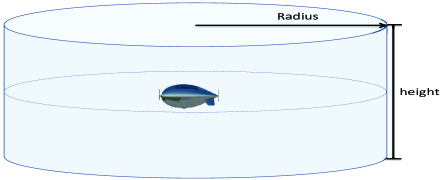
Then, the HeliNet Project designated another stationary model for HAP [34]. The stationary model is a cylindrical model with a diameter of four km and a height of three km, as shown in Fig. 3. A HAP is considered to be stationary if it does not flee from this cylindrical airspace 99.9% of the time. There is another similar quasi-stationary model for HAP that allows a HAP to change its altitude over time, bounded by an upper limit (e.g., 26 km) and a lower limit (e.g., 20 km), with the cylinder’s radius ranging from one km to five km. The quasi-stationary model is an important and commonly used model for HAP, despite the fact that a HAP can fly at a speed of 110 km/h. However, in some practical applications requiring a HAP to remain stationary, the HAP (especially an airship) will fly in a circular trajectory with a small radius (e.g., one km).
II-B2 Energy sources and endurance
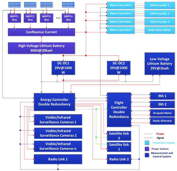
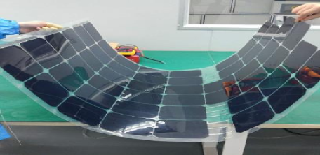
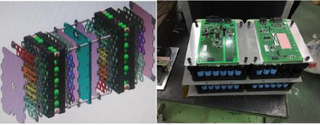
A HAP is huge and has many mission systems; thus, it’s indisputable that the avionics system of a HAP will be sophisticated. Fig. 4 illustrates an avionics system of our airship, from which we can observe that a HAP will be extremely energy-consumption. Up to now, HAPs have been able to utilize three types of energy sources, including fuel energy, beam energy, and solar energy. Due to the limited capacity of fuel tanks, HAPs powered by conventional energy sources have a short flight duration. Additionally, the processes of takeoff and landing for a HAP are time-consuming and energy-intensive. Then, the cruise duration of conventional energy-driven HAPs will be significantly shortened, and their application scenario will be rather limited. HAPs can be charged by energy beams from external energy sources. The concept of power transmission using radio waves has a long history, going back almost one hundred and forty years to Heinrich Hertz. In the 20th century, a stationary high-altitude relay platform (SHARP) project demonstrated such a process of transmitting microwave power from a large ground antenna system to a HAP [35]. Except for microwave beam power, laser beams can also be explored as energy sources for HAPs. Nonetheless, microwave or laser beam power will bring the risk of high-power irradiation; thus, the practical application of beam-powered HAPs is severely restricted. HAPs are deployed in the stratosphere to take advantage of the abundant solar energy available. As a result, modern HAPs are designed with a focus on efficiently harnessing solar energy, taking into account operational costs and safety requirements. HAPs are bulky, and then a plethora of solar panels can be attached to HAP surfaces to convert solar energy into direct current (DC) power. Fig. 5 shows the flexible solar panels attached to the surface of our airship. Solar-powered HAPs will also utilize batteries (e.g., li-ion battery) to power HAP functions and maintain the platform’s attitudes during dark nights, as shown in Fig. 6. Besides, the fuel energy plays a crucial role in the flight altitude control of HAPs (exactly, airship). For instance, our airship will increase its buoyancy and flight altitude by producing hydrogen, and reduce its buoyancy and flight altitude by consuming hydrogen though hydrogen fuel cells.
HAUAVs can utilize two types of energy sources, including fuel energy and solar energy. However, as HAUAVs fly in the atmosphere, the deployment of solar-powered HAUAVs is closely related to weather conditions. On the contrary, fuel-powered HAUAVs are relatively robust to weather conditions and can fly for many tens of hours. As a result, fuel-powered HAUAVs have a wide range of applications in the military field, such as used for ground attack, ground surveillance, and early warning. LAUAVs can also utilize two types of energy sources, i.e., fuel energy and electrical batteries. Owing to the advantages in manufacturing and maintenance costs, battery-driven LAUAVs are much more popular than fuel-powered LAUAVs. However, the total battery capacity of a LAUAV is limited owing to the constraint on its payload capability. Currently, depending on applications, the limited energy can support a battery-driven LAUAV to fly for only a few minutes, or at most a few tens of minutes.
Based on the above analysis, it can be concluded that effective energy management is of utmost importance for NSIN as it directly impacts its overall lifespan. The energy consumption of NSIN consists of consumption for flight control and performing missions (e.g., communications). The energy consumed by flight control includes that for propulsion and flight attitude control. The types and characteristics (e.g., size and weight) of platforms in NSIN also affect flight control consumption. Communication activities will generate communication energy consumption that includes circuit consumption (e.g., energy consumed by mixers, frequency synthesizers, D/A converters, and so on) and transmission consumption. The types of communication payloads and adopted communication techniques will also significantly affect the amount of communication energy. Many mechanisms related to flight control and transmissions can be adopted to improve the energy efficiency of airborne platforms in NSIN. For example, as the engine power of a UAV will decrease and then increase as the flight speed increases [36], the flight speed of a UAV should be optimized to reduce engine power. Reasonable flight plans should be made to reduce engine power, and maneuvers like small-radius turns and rapid increases in the flight altitude and speed should be reduced. Additionally, the issue of optimizing the deployment altitudes of UAVs should be studied. A low deployment altitude will lead to reduced engine power. However, the non-line-of-sight (NLoS) probability of communications may increase when UAVs are deployed at low altitudes. As a result, greater transmission power will be required to satisfy the QoS requirements of terrestrial serving terminals. Certainly, UAVs can reduce energy consumption by offloading computational tasks to HAPs [37, 38, 39, 40].
Summarily, the energy constraint of NSIN is determined by that of HAPs, HAUAVs and LAUAVs. Owing to the stringent constraints on aspects of platform size, weight, and payload capability, LAUAVs in NSIN have the most stringent energy consumption constraints.
II-B3 Payload and power capability
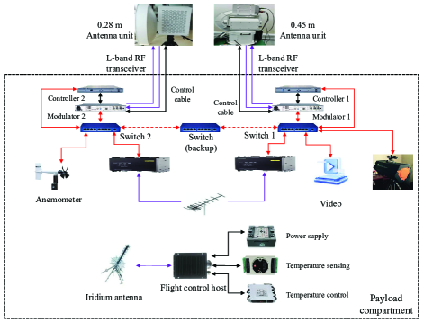
Payload and power capability are significant differences between a HAP and a UAV. The payload and power capability of a HAP are much greater than that of a UAV. For example, Fig. 7 shows a diagram of the payload system of our airship, where many different types of payloads are mounted into the payload compartment to accomplish diverse missions. The recent near-space airship “Stratobus” also can carry up to 450 kg of payload, which envisions unprecedented potential for integrating many diverse types of mission systems (e.g., computing, communication, sensing, positing, navigating, timing (PNT), and intelligence, surveillance, reconnaissance (ISR) systems) and simultaneously providing multiple kinds of services. In this way, the efficiency of completing missions by resorting to a HAP can be greatly improved. Further, owing to the advantages of high payload capability, a HAP can conduct many crucial tasks that cannot be completed by a UAV, e.g., the collection of sufficient measurement data inside a typhoon. To complete this task, an airborne platform needs to carry and drop a large number of communication and sensing nodes into the interior of the typhoon. Meanwhile, the airborne platform should enable the collection of data from these measuring nodes. For a UAV, it has limited payload capacity and thus cannot carry out many critical missions.
Besides, a HAP can generate a greater power rating than a UAV, e.g., the “Stratobus” has a 1000 solar generator and high-energy density batteries, which are able to generate a power rating of eight kW. The great power generation capability indicates that a HAP can provide communication services for a lot of users with high bitrate requirements. Meanwhile, higher power indicates that a HAP has a larger footprint, and the degradation of signal quality caused by meteorological attenuation will be alleviated by increasing transmit power to some degree.
II-B4 Footprint
The large footprint is one of the most significant features of a HAP, which popularizes both research and utilization of it. Thanks to a high deployment altitude, a HAP has a great probability of enabling line-of-sight (LoS) propagation of around 565 km in diameter. Due to topological obstacles and radio propagation characteristics, a realistic coverage area for a HAP is around 240 km in diameter over most land areas and around 500 km over oceans or plains (where the topography is flat). Owing to their wide footprint, HAPs have been envisioned to connect remote areas where traditional Internet connectivity is unserved or underserved. Theoretically, only thousands of HAPs are required to establish global interconnectivity. Besides, the wide footprint enables a HAP to be considered a satellite alternative.
Different from a HAP, a UAV has a relatively small footprint. Yet, like a HAP, the size of the UAV footprint is closely related to the deployment environment. For instance, when deployed in a rural area, a UAV will have a large footprint because of the absence of severe shadow fading or signal blockage caused by high-rise buildings. A UAV has a small footprint when deployed in a dense urban area. As a result, extensive attention has been paid to the topic of extending the UAV footprint by optimizing the UAV deployment altitude.
II-C Design Consideration of NSIN
II-C1 Heterogeneity
As presented above, NSIN consist of many different airborne platforms that are quite different in terms of deployment altitude, footprints, computing power, and so on. Therefore, heterogeneity is the most important feature of NSIN and must be taken into account in the NSIN design process, especially in the protocol design of NSIN.
HAPs and UAVs collaboratively construct a network with a multi-tier structure. In this multi-tier network, different footprints of a HAP and a UAV may lead to footprint overlap and inter-tier interference. To this end, advanced beamforming schemes and spectrum sharing mechanisms [41] should be designed to alleviate the interference so that the performance of NSIN will not be degraded.
As presented above, HAPs and UAVs have distinct abilities, resulting in the fact that HAP communication systems and UAV communication systems may adopt diverse communication paradigms. For instance, they may work at different frequency bands, explore different modulation and demodulation techniques, and adopt diverse signal exchange methods. To this end, the design of NSIN should achieve some technical breakthroughs in terms of the integrated protocol design, the integrated network framework design, the optimal deployment of gateways, and so on.
UAVs are widely used in various scenarios due to their flexible and agile deployment capabilities. In comparison, HAPs have larger sizes and heavier masses, making them less flexible than UAVs. Consequently, the mobility control of NSIN cannot be modeled and optimized using the same approaches as UAVs. HAPs and UAVs also exhibit different communication persistence and lifespans, which should be taken into account when designing protocols and optimizing network resources for NSIN.
II-C2 Cooperation
The cooperation between HAPs and UAVs can significantly enhance the performance of NSIN. In many applications, increasing the number of collaborative airborne platforms can greatly improve the service ability of NSIN.
On one hand, the footprint of a HAP is much larger than that of a UAV, so the collaboration of HAPs and UAVs will greatly extend the coverage of UAV networks [42]. On the other hand, in some areas, such as mountainous and metropolitan regions, the coverage of HAP networks can be improved by deploying UAV relays. By acting as relays, UAVs can enhance the quality of HAP-UAV-user links in a flexible and proactive manner. Airborne platforms in NSIN can act as aerial network nodes with diverse functionalities, including sensing nodes, computing nodes, communication nodes, and so on. Thus, through the cooperation among these airborne platforms, NSIN can complete some critical tasks (e.g., search, rescue, surveillance, and earth observation) faster and more accurately. In non-cooperative HAP and UAV networks, each airborne platform may be required to accomplish several tasks, the process of which will not only lead to great task latency but also occupy a significant amount of radio resources (e.g., frequency and power). The robustness of NSIN can also be enhanced by airborne platform cooperation; as a result, the heterogeneous NSIN will keep organized even in the case of platform or link failure.
II-C3 Disruption and delay prone network
The link disruption is likely to occur in NSIN. Link disruption will be caused by many factors, including airborne platform-related factors (e.g., platform mobility, failure/replacement, interference, and antenna pattern) and propagation environment-related factors (e.g., blockage and various types of propagation fading). Delays in NSIN information transmission may be caused by long-distance transmission, poor link status, reduced network throughput, packet queueing, and network congestion, etc.
Therefore, some mechanisms should be designed to tackle the link interruption issue and reduce transmission delay in NSIN, which include beam alignment, mobility control, interference management, transmission protocol design, queue management, and congestion control. The reader can refer to more details of the mechanism design for NSIN in Section X.
II-C4 Airborne platform constraints
When designing NSIN, one should simultaneously consider the constraints of HAPs and UAVs in terms of their sizes (or space), weights, mobility, and power. SWMAP constraints significantly affect the endurance, sensing, computation, and communication capabilities of NSIN.
-
•
Size or space: Airborne platforms with larger sizes or more space have a greater payload capacity and more mounting points. Thus, a larger airborne platform can carry more powerful sensors and peripherals, such as Internet of Things (IoT) devices, transceivers, hubs, cameras, three-axis accelerometers and gyroscopes, magnetometers, barometers, the global positioning system (GPS), and electro-optical pods. In this way, these platforms have the ability to complete preset tasks more accurately, quickly, and effectively. However, the larger the size of the platform, the heavier the platform. Correspondingly, the cost of manufacturing and operating the platform is higher, and its popularity is limited.
-
•
Weight: The weight of both the payload and the airborne platform itself will significantly affect its endurance. The weight of the payload is a crucial performance indicator for an airborne platform. For a HAP, it is closely related to the locations of the pods mounted on the HAP, and a HAP can carry more payloads by deploying decentralized pods. The lighter platform also enables it to mount more payloads and extends the platform’s endurance. In fact, the design and manufacturing of lightweight airborne platforms is a significant trend. In recent years, advanced lightweight materials such as carbon fiber have been widely utilized in NSIN. For example, we have utilized carbon fiber materials to manufacture the propeller blades of our airship, as shown in Fig. 8, which greatly enhance the propeller structure, reduce the weight of the propeller, and lower energy consumption. The Aquila drone engineered by Meta has a tremendous wingspan (141 feet) compared to a Boeing 737’s 113 feet. Furthermore, being built with carbon fiber, Aquila weighs only around 900 pounds, which is approximately half the weight of a smart car.
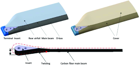
(a) Structure of a blade of a propeller 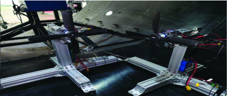
(b) Ground testing Figure 8: Structure of a carbon fiber propeller blade of our airship, and a ground scaling test experiment. -
•
Mobility: Mobility is one of the most important characteristics of an airborne platform, which contributes a lot to its popularity. Compared to stationary platforms, mobile airborne platforms have many merits, e.g., they can improve the fairness of network service, proactively improve channel quality, enhance network performance, and accomplish 360∘ panoramic sensing and monitoring of specific areas or targets. The degree of performance improvement is also related to the flexibility of the platform. Airborne platforms have some constraints on their moving directions and speeds, and the types of airborne platforms affect their maneuverability. For instance, compared to a LAUAV, a HAP has greater maneuverability limitations owing to its larger size and inertia. To this end, NSIN designers need to separately enforce mobility constraints for airborne platforms in NSIN.
-
•
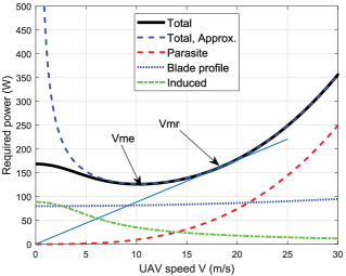
Power consumption: Power consumption constraints are key consideration during the process of designing NSIN and play a crucial role in prolonging its lifetime. Different types of airborne platforms have diverse requirements for power consumption constraints. In particular, small and battery-driven platforms have stricter power constraints. Although solar-powered airborne platforms are not much more energy-sensitive than battery-driven platforms, developers have to design energy-aware protocols for them such that they can operate normally during hard and long nights. To save power consumption for accomplishing tasks, NSIN developers should also pay attention to the design of energy-efficient management mechanisms. The propulsion power consumption of airborne platforms can be much greater than that for accomplishing tasks. The amount of propulsion power consumption is closely related to the maneuverability of the platforms. Eq. (1) presents a propulsion power consumption model (in W) of an airship derived from the aerodynamic theory and computational fluid dynamics (CFD) numerical simulation results.
(1) where , , and represent the flight speed, the volume, and the slenderness ratio of the airship, a Reynolds number, and the density of air. Fig. 10 and Fig. 10 also illustrate the propulsion power consumption versus the platform flight speed of a HAP and a rotary-wing UAV, respectively. From these figures, we can know that the movement control of airborne platforms is extremely energy-consumption. Therefore, designers should take into account the energy-efficient movement control of airborne platforms when deploying NSIN to accomplish tasks.
II-C5 Situation assistance
The NSIN is deployed in a rather complex 3-D airspace. To effectively support network construction, management, utilization, and operation, NSIN designers should be aware of, analyze, and exploit situational information related to NSIN.
The situation of NSIN mainly includes the network situation and the security situation. The network situation of NSIN characterizes such NSIN statuses as resources, capabilities, capacity, and traffic. In terms of resources, the network situation involves the status of spectrum, power, storage, and platforms. Network capability status describes the communication, computing, sensing, PNT, and ISR capabilities of NSIN. Capacity status includes link capacity, sub-network capacity, and network capacity. Regarding the traffic situation, the network situation describes the status of network and node traffic congestion, as well as the types of traffic present in the network, such as control or payload traffic. It is noteworthy that different types of traffic have distinct service requirements on NSIN, and the necessity of merging multiple different types of traffic into a network has been widely recognized.
In a designated time and space range, elements (e.g., neighboring flight platforms, terrain, and meteorology) of the airspace environment may threaten the safe flight of an airborne platform. The security situation refers to the spatial and temporal distribution of the level of threat to the safe flight of platforms. It is an important prerequisite for the safe and efficient sharing of airspace by multiple heterogeneous airborne platforms. For instance, airborne platforms in NSIN need to fly to a target airspace autonomously and share the limited and complex airspace when carrying out the mission. Then, when planning the trajectories of airborne platforms, developers should consider cooperative planning with civil airspace, the avoidance of obstacles, and the collision with other flight platforms in the neighboring area.
II-C6 Aviation regulations
Owing to safety, privacy, and harmonious operation concerns, the aeronautical regulation activities of NSIN are regulated by national civil aviation authorities. It indicates that NSIN must operate under civilian laws and be subject to civilian regulations and licensing to guarantee safe and harmonious operations. Civil aviation authorities of different countries may formulate different rules for NSIN. However, relevant rules are formulated mostly considering the following factors: 1) The categories, sizes, and weights of airborne platforms (e.g., airships, balloons, and aircraft). For instance, airborne platforms weighing more than 0.25 kg must be registered in most countries. 2) The pilot or control methods of airborne platforms, i.e., unmanned or manned. For example, current aeronautical regulations restrict unmanned HAPs from flying in civilian airspace, but the deployment of manned HAPs may be a step towards allowing HAPs in such airspace. 3) The flight altitude and safe distance towards other objects, e.g., LAUAVs are not allowed to fly above 120 m in China. 4) The flight regions of airborne platforms, whether they are above an urbanized area, restricted areas, near national borders, or near airports. For instance, airborne platforms are prohibited from flying within five km of the national border in China. 5) The urgency of flight missions, e.g., the flight plan approval process will be simplified in some countries during the period of executing anti-terrorism and emergency missions.
II-C7 Spectrum regulation of NSIN
At the World Radiocommunication Conference in 1997 (WRC-97), the frequency bands, i.e., 47.2-47.5 GHz (downlink) and 47.9-48.2 GHz (uplink), further confirmed at WRC-19, were first allocated to HAPs for worldwide usage. This proposal was promoted by the US as the federal communications commission (FCC) approved the application of the Sky Station International Corporation to utilize this 2 × 300 MHz band for stratospheric application of Internet service and interactive video communication service relay in 1996. Yet, concerning the great rain fading and immature technical solutions in the upper frequency bands, some lower frequency bands were agreed to be occupied by HAPs at WRC-2000. Thereafter, technological advances and the pressing requirement of providing global broadband applications resulted in a review of the current spectrum regulatory provisions. At WRC-19, delegates agreed to allocate a portion of millimeter-wave (mmWave) frequency bands to HAPs for worldwide usage. The WRC-23 agenda item 1.4 also explained the sharing and compatibility studies of HAPs as International Mobile Telecommunications (IMT) base stations for mobile services in some frequency bands below 2.7 GHz. The detailed spectrum regulation for HAP networks is summarized in Table VI.
|
Allocated frequency (in GHz) | Allocated Time | Region | ||||||
|
|
|
Worldwide | ||||||
| Internet services | 1.885-1.98, 2.01-2.025, and 2.11-2.17 | WRC-2000 |
|
||||||
| Internet services | 1.885-1.98 and 2.11-2.16 | WRC-2000 | Region 2 (Americas) | ||||||
| Broadband services | 31-31.3, 38-39.5 | WRC-19 | Worldwide | ||||||
| Fixed services | 21.4-22 and 24.25-27.5 | WRC-19 | Region 2 | ||||||
| IMT base station |
|
WRC-23 |
|
As for UAV networks, the spectrum is allocated in accordance with usage. The control and non-payload communication (CNPC) link is established to ensure the safe operation and efficient control of UAVs. As shown in Table VII, some frequencies for UAV CNPC links are allocated with some usage restrictions. Yet, partial frequencies fall in the bands allocated to fixed satellite services. Then, the sharing compatibility issue between UAV CNPC links and satellite-ground links should be tackled. Payload links refer to the links used for other radio equipment than those for CNPC links. The payload devices (e.g., camera, repeater, and flying base station) are closely related to missions, which can transmit measurement and perception data from a UAV to the ground. Table VII also depicts the frequencies allocated to UAV payload links.
![[Uncaptioned image]](/html/2310.09025/assets/x12.png) |
II-D Promising Use Cases of NSIN
As presented above, airborne platforms in NSIN can fulfill various roles. By functioning as aerial macro-base stations, they have the ability to offer cost-effective communication services over a wide coverage area. Specifically, when the coverage radius of a HAP is 50 km and the maintenance cost is $500 per hour, the communication cost will be $1.325 million per gigabit per year. It indicates that the coverage cost per unit area of a HAP is only 6.7‰ times that of a ground macro-base station. They can act as mobile relays to connect isolated information islands, collect data, and deliver data back to TN or NTN gateways. For instance, airborne relays can be deployed to facilitate communication between offshore vessels. Particularly, vessels within 200 km offshore can be interconnected by deploying two HAP relays when the coverage radius of a HAP is 50 km. Besides, by deploying 130 HAPs, any two vessels within 200 km offshore of China can be connected. Airborne platforms can serve as aerial edge computing nodes [43, 44, 45], effectively reducing network latency by shifting computing capabilities from the cloud to the network edge. Enabling the ability of edge computing, one can regard NSIN as content delivery networks (CDN), which enable low-latency and high-interaction content delivery services. NSIN can provide network access services for rural or remote areas with inadequate communication infrastructures [46]. They can also act as caching nodes [47, 48, 49]. By caching content in NSIN, the network resource allocation and service abilities of data centers can be proactively optimized according to users’ QoS requirements. The aforementioned essential functions of airborne platforms provide NSIN with promising application prospects for various critical use cases, as discussed below.
Emergency communication: Emergency communication is one of the most important goals of deploying NSIN. NSIN is resistant to natural disasters and geographical limitations. When TN are disrupted due to earthquakes, floods, mudslides, and other disasters, NSIN can be quickly deployed to recover communications and establish information transmission channels for emergency rescue. Additionally, NSIN can act as complement radio access networks to sustain services of TN when terrestrial flash crowd traffic occurs in densely populated areas [50, 51].
QoE enhancement: One can deploy NSIN to assist TN in enhancing users’ service of experience. Take video transmission as an example, Intra-coded pictures (I frames) and Predictive-coded Pictures (P frames) are the basic data of video traffic. The codec compression ratios of I and P frames are great, and thus we require great network bandwidth to deliver I and P frames. The enhancement frames (i.e., Bidirectionally predicted pictures (B frames)) are used for improving the quality of received videos. The codec compression ratio of B frames is small, and the required network bandwidth for the transmission of B frames is small. One can then choose to deliver I and P frames via TN and transmit B frames through NSIN. After combining I, P and B frames on the terminal end, users’ service experience can be greatly enhanced. In addition, for applications involving video streaming and image rendering, real-time processes of such operations as video coding and decoding, orchestration, geometrical transformation, project transformation, and perspective transformation, are crucial. By shifting the rendering ability from the cloud to the NSIN network edge, the process latency can be greatly reduced, and then the potential of enabling emerging time-critical applications such as extended-range (XR) or metaverse via NSIN-assisted TN may be unlocked.
Cargo-UAV applications: It is envisioned that numerous cargo-UAVs will fly in the airspace of densely populated cities. To ensure the safe operation of these cargo-UAVs, reliable and low-latency communication links among them and controllers (enforced by law) must be established, and a large amount of data about them should be collected and analyzed continuously and timely. HAPs in NSIN can be deployed to satisfy the above requirements perfectly. Owing to the high deployment altitude, HAPs can establish communication links of good quality with cargo-UAVs. Thus, controllers can control cargo-UAVs in a reliable and low-latency manner via HAPs. The on-board processors of HAPs also have strong computing and storage capabilities, which can handle the large amount of data generated by cargo-UAVs timely.
ITS applications: NSIN can provide improved coverage and surveillance services for intelligent transportation systems (ITS). UAVs in NSIN can achieve the goal of local service enhancement, and HAPs in NSIN can provide wide coverage services. Take railway transportation as an example, NSIN will become a new regime for continuously monitoring the surroundings of railways and detecting abnormal events around railway tracks. The service requests from high-speed cars and trains in ITS are increasing with the proliferation of ITS services. However, it is hard for stand-alone TN to provide low-latency and continuous coverage services for these transportation vehicles. To satisfy their requirements, these vehicles can establish connections with suitable network platforms in NSIN. For instance, high-speed cars and trains do not need to frequently hand over between access points by accessing HAPs. This reduces the signaling overhead and handover latency significantly.
Communications among Non-Terrestrial Platforms: As is known, 71% of the earth’s surface is covered by the ocean. Humans have only explored and charted 5% of the ocean, and there are rich resources waiting to be explored in the ocean. As a result, more and more fixed or mobile offshore platforms (e.g., gas and oil rigs, scientific expeditions, and surveillance platforms) are being established to exploit the abundant resources on the seabed and explore the unknown environments. Nowadays, these platforms exchange data with their terrestrial controllers through renting satellite links, which inevitably results in long transmission latency. NSIN, which is much closer to these platforms, can be deployed as relay networks to establish the connection between them and their controllers. In this way, the end-to-end (E2E) transmission latency among these platforms and controllers can be significantly reduced.
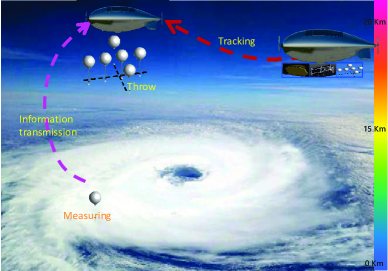
Meteorological monitoring: Meteorological monitoring (e.g., typhoon monitoring) is of great importance in both civilian and military research fields. Most existing meteorological monitoring systems are space- or ground-based. However, space-based systems face limitations in ensuring continuous monitoring due to satellite orbit constraints. Ground-based systems have limited detection ranges and poor flexibility. NSIN-based monitoring systems can overcome these shortcomings by offering continuous monitoring capabilities throughout the entire life cycle of climate phenomena like typhoons, snow, and rainfall. Therefore, the development of NSIN-based meteorological monitoring systems is expected to be a significant trend in the near future. Fig. 11 shows a proposal of monitoring typhoons we are working on using NSIN.
Proliferation of IoT services: Existing terrestrial infrastructures are limited and increasingly unable to support the highly demanding IoT services. For example, more and more IoT devices are expected to be deployed in such areas as forests, mountains, and oceans where there is no or rare TN coverage. In this context, NSIN is envisioned as a key infrastructure to complement existing terrestrial infrastructures to collect data or offload computationally intensive tasks from IoT devices and charge them in an efficient and cost-effective way [52, 53, 54, 37].
II-E Summary and Discussion
NSIN are significant heterogeneous and multi-layered networks consisting of the HAP, HAUAV, and LAUAV network segments. There are many notable differences between HAP and UAV, which prevent most protocols designed for UAV networks from being applied directly to NSIN. Researchers and designers should conceive protocols and network management architectures for NSIN that take full account of the heterogeneity among airborne platforms as well as their cooperation. Besides, there are many promising use cases for NSIN where HAP networks play an irreplaceable and fundamental role. However, the impact of the unstable movement of HAP on the performance of HAP networks is seldom studied. The monitoring data from our field experiments showed that an airship rotated around one revolution per minute, and its attitude angle could vary greatly. The unstable movement of the platform can result in position shifting and deformation of the HAP’s footprint. As a result, users close to the boundary of the footprint will frequently trigger handoffs, and their QoS requirements are hard to be satisfied. A HAP moves with six degrees of freedom, i.e., X-direction, Y-direction, Z-direction, yaw, roll, and pitch. The movement of the HAP along the X- and Y-directions will not affect the size of the footprint, but rather its location. The movement along the Z-direction will result in the expansion or contraction of the covered area. Further, the changes in its footprint are closely related to the installed antenna type of the HAP. For instance, given a high-directional antenna, the area of the coverage area expands with the uplift of the HAP; however, in the case of a low-directional antenna (or omnidirectional antenna), the area of the coverage area shrinks with the uplift of the HAP. Meanwhile, in the case of rotation, beams will change, and beamforming technologies should be enabled to resist the impact of platform rotation.
III Channel Modeling of NSIN
A good understanding of the channel characteristics of NSIN, key physical parameters of the channel, and channel modeling issues lays the foundation for the design of NSIN. The signal propagation environment of NSIN is quite different from that of TN, satellite networks, and UAV networks. The NSIN propagation environment goes through the stratosphere and troposphere, where the temperature, humidity, and atmospheric pressure vary greatly. Besides, the platforms in NSIN have special SWMAP characteristics. As a result, existing channel models of terrestrial, satellite, and UAV networks may not be directly applied to model channels of NSIN.
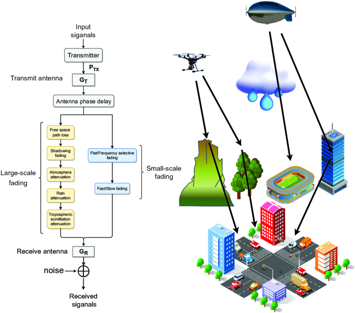
In this section, we first discuss the phase delays of different types of antenna arrays onboard NSIN platforms. Next, we discuss the channel propagation characteristics of NSIN from both large-scale fading and small-scale fading perspectives. Fig. 12 illustrates the components of a typical channel model of NSIN. Third, we provide a detailed explanation of the existing channel models customized for NSIN.
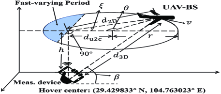
III-A Phase Delay
Let denote the location vector of the -th array element with respect to (w.r.t) a reference array element and the DoA unit vector with and representing the elevation angle and the azimuth angle, respectively, the phase delay of the -th array element w.r.t the reference array element can then be given by , where represents the inner product operation and with being the carrier wavelength. The -th element of the array matrix can be expressed as .
Unfortunately, an airborne array antenna will jitter due to the unstable movement of the airborne platform, which challenges the analysis of the phase delay. In this subsection, we discuss the impact of jittering on phase delay. Denote as a rotation matrix capturing the attitude of an airborne platform, which can be measured by yaw, pitch, and roll angles. The impact of attitude changes on the array element can be modeled as , and denote as the -th element of . We can then summarize the expressions of phase delays and steering matrixes of three typical types of antenna arrays, including linear antenna arrays, rectangular antenna arrays, and circular antenna arrays in Table VIII.
| Array structure | Phase delay | Steering vector/matrix | ||||||||
|---|---|---|---|---|---|---|---|---|---|---|
![[Uncaptioned image]](/html/2310.09025/assets/x15.png)
|
|
|||||||||
![[Uncaptioned image]](/html/2310.09025/assets/x16.png)
|
|
|
||||||||
![[Uncaptioned image]](/html/2310.09025/assets/x17.png)
|
|
|
III-B Large-Scale Fading
Large-scale fading happens because electromagnetic (EM) waves between Tx and Rx are blocked and/or shadowed by large objects (e.g., buildings, hills, and trees). It therefore includes free space path loss (FSPL) and shadow fading. The strength of large-scale fading is closely related to the distance between Tx and Rx and is typically frequency-independent. Besides, rain, atmospheric gases, and scintillation may lead to large signal fluctuations.
III-B1 Free space path loss
As the EM wave spreads from Tx to Rx over an increasing area, the transmitted signal attenuates with increasing distance. The results of channel measurements, as shown in Fig. 13, indicate that the value of FSPL (in dB) can be calculated by [22]
| (2) |
where is the path loss exponent, the distance between a user and an airborne platform, the extra path loss, depending on carrier frequency, flight altitude of the airborne platform, and the topography the propagation environment.
III-B2 Shadow fading
The shadow fading is closely related ground users’ elevation angles towards an airborne platform. Shadowing is the deviation of the received power of an EM signal from its averaged value. Then, shadow fading is usually modeled using a statistical distribution. Experimental results in [22] showed that depending on platform’s altitude, it is suitable to model shadow fading using generalized Gamma distribution and Log-normal distribution. Besides, both the mean and the variance of shadow fading depend on the elevation angle, and a large angle results in a small mean and variance.
III-B3 Atmosphere attenuation
The atmospheric attenuation model characterizes the EM wave absorption of atmospheric gases. Its strength depends on the carrier frequency, elevation angle, transceiver deployment altitude above sea level, and absolute humidity. This type of attenuation should be considered at frequencies above ten GHz. Nevertheless, one should also calculate this type of attenuation at any frequency above one GHz when the elevation angle between Tx and Rx is below ten degrees. ITU-R P.676 (in Annex 1) outlines in detail the computing procedure of atmospheric attenuation [55].
III-B4 Rain attenuation
Rain attenuation is a phenomenon relative to the EM wave frequency and the rainfall rate. Rain causes attenuation in EM waves through the processes of absorption and scattering. Rain attenuation is a critical factor to consider for frequencies above six GHz. As for signal transmission in typhoon environments, it is essential to calculate the rain attenuation for frequencies in the several hundred MHz range, as the rainfall rate can reach up to 72.8 mm/h [56].
ITU-R P.618 [57] described a comprehensive approach for estimating the long-term statistics of rain attenuation, taking into account the factors of frequency, rainfall rate, elevation angle, and polarization. In addition to this, modeling rain attenuation can be achieved through the application of a synthetic storm technique and the utilization of raindrop size distribution models like lognormal and optimized models [58]. However, the mentioned rain attenuation models are independent of time series. As a result, it is not enough to design NSIN (especially the PHY and MAC layers of NSIN) using these models. Then, one should propose time series rain attenuation models. ONERA -state Markov chain and the German Aerospace Research Center (DLR) rain attenuation model are two types of well-known models of NSIN and satellite communications. There are three components in an ONERA model. The one describes a coarse attenuation time series with values of “rain” and “no rain”. The one is a microscopic model describing attenuation time series with high resolution. The one combines the two obtained time series to generate a complete long-term attenuation time series [59]. The DLR model comprises a generic component and a specific set of parameters. These parameters enable the adjustment of the time series generator to simulate scenarios with different frequencies, elevation angles, and climatic zones [59].
III-B5 Tropospheric scintillation attenuation
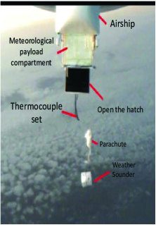
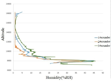
Tropospheric scintillation attenuation indicates rapid amplitude and phase fluctuations in received signals. Tropospheric propagation should be considered for frequencies above six GHz, and the tropospheric scintillation effect increases with frequency, being especially significant above ten GHz. Sudden changes in the refractive index caused by variations in water vapor content, temperature, and barometric pressure can cause signal fluctuations. Fig. 14 depicts an experiment of dropping three meteorological sounders from our airship in a row and the recorded humidity data of them. Experimental results show the significant variation of water vapor content. Additionally, the scintillation effect becomes more pronounced at lower elevation angles due to longer propagation paths. The ITU-R P.618 presents an accurate prediction method for the scintillation attenuation amplitude [60]. It shows that the tropospheric scintillation attenuation may be dozens of dB in the case of a low elevation angle. The scintillation attenuation can be negligible under a high elevation angle case (e.g., ). Nevertheless, one should also consider the tropospheric scintillation attenuation in the case of a high elevation angle during rain.
III-C Small-Scale Fading
Small-scale fading is caused by the constructive and destructive interference of multi-path signals between Tx and Rx. It depends on the carrier frequency and occurs at a spatial scale approximately equaling to the wavelength of the signal. Small-scale fading characterizes the rapid fluctuation in received signal strength over short distances and short time periods. Small-scale fading includes flat fading, frequency selective fading, fast fading, and slow fading, which are affected by the EM propagation environment.
III-C1 Flat fading
In flat fading, the signal amplitude remains unchanged during each symbol duration, but the amplitude and phase of the symbol may change over short distances. To mitigate the impact of flat fading, some techniques, such as diversity reception and error correction coding, should be utilized.
In flat fading, all frequency components of the received signal fluctuate simultaneously and in the same proportion. As a result, this type of fading is also called non-selective fading. One can model the flat fading channel using a two-state model. This model distinguishes two states: a good state corresponding to LoS and slightly shadowed channel conditions, and a bad state corresponding to severe shadowed channel conditions. A semi-Markov model can capture the state duration. One can utilize a Loo distribution to characterize the fading in each state. The received signal consists of the direct path signal and multi-path components. 3GPP TR 38.811 provides system-level evaluations of flat fading [61].
III-C2 Frequency selective fading
Frequency selective fading occurs when the symbol duration is shorter than the delay spread. It may lead to inter-symbol interference (ISI). An equalization technique should be employed to mitigate the impact of this type of fading. This type of technique utilizes a digital filter at Rx to counteract the channel effect. Frequency selective fading, as the name indicates, affects diverse spectral components of signal with varying amplitudes. After modifying some crucial parameters related to NSIN scenarios, the procedure presented in subsection 7.5 of 3GPP TR 38.901 [62] should be utilized to model the frequency selection fading channel. The elevation angle between a ground user and a HAP is a crucial parameter. NSIN scenarios with fewer clusters than those specified in 3GPP TR 38.901 require the inclusion of angular scaling factors in cluster generation [62].
III-C3 Fast fading
In a fast fading channel, the channel impulse response exhibits rapid variations within the symbol duration. Fast fading distorts the shape of the baseband pulse, resulting in linear distortion that causes inter-symbol interference (ISI). Adaptive equalization helps reduce ISI by eliminating the linear distortion induced by the channel.
III-C4 Slow fading
In a slow fading channel, the CIR changes at a much slower rate than the transmitted baseband signal. One can utilize receiver diversity and error correction coding techniques to combat the effects of slow fading.
III-D Existing Channel Models of NSIN
To fully comprehend the capabilities of NSIN, it is crucial to have a profound understanding of NSIN channel models. This paper focused on summarizing and analyzing NSIN radio-frequency (RF) channel models, and the reader can refer to [11] for HAP free space optical (FSO) channel models. Besides, NSIN channel modeling includes HAP channel modeling and UAV channel modeling, where UAV channel modeling has been extensively studied. In this subsection, we focus on the discussion of HAP channel modeling and analysis of the differences between HAP channel models and UAV channel models.
III-D1 HAP channel models
In the research community, recent HAP channel models can be primarily categorized into two groups: deterministic models and stochastic models. These classifications are outlined in Figure 15.
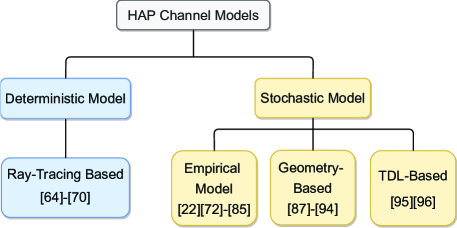
Deterministic model: A deterministic channel model requires constant parameters (e.g., angle of arrival/angle of departure (AoA/AoD)) during simulations [63] and leverages some methods (e.g., ray-tracing, digital map-assisted, and two-ray[63]) to estimate the CIR or channel coefficients. The accuracy of deterministic models relies on extensive and environment-specific databases, which can characterize the terrain topography, the electrical properties of buildings, and other obstacles. Besides, model parameter adjustment according to propagation measurement data is required.
This type of HAP channel modeling method has attracted much attention. For example, in [64], a ray-tracing-based propagation channel model between a HAP and a ground mobile station was developed. This model examined the effect of angle variations on propagation loss by utilizing a ray-tracing tool that accounted for changes in elevation and azimuth angles. In [64], the authors employed a ray-tracing technique to compute the power level and path loss experienced by a mobile user, as mentioned in [65]. By analyzing the outcomes, the propagation parameters, including path loss and Rice factor, were derived as functions of elevation and azimuth angles. In addition to evaluating angle variations, the authors investigated the effects of building height and street size on the propagation loss of downlink HAP channels in an urban environment. They utilized a ray-tracing tool to conduct this study and published their findings in [66, 67, 68]. The research presented in [69] examined the propagation path loss of the downlink HAP channel using two-dimensional ray-tracing and the uniform theory of diffraction. The study evaluated the effects of wave reflection from building walls and the ground, as well as wave diffraction. Diverse from the above channel modeling methods using ray-tracing tools to simulate wave reflection and diffraction, the work in [70] studied the impact of terrestrial clutter on downlink HAP propagation loss and developed a HAP propagation path loss model including free space path loss and clutter-induced attenuation using the ray-tracing data.
Statistical model: Without using measurement data, a statistical model utilizes statistical distributions and empirical parameters to capture the characteristics of propagation channels in a low-complexity manner and includes the empirical channel model, the geometry-based stochastic model, and tapped delay line (TDL)-based stochastic model.
In empirical channel model methods, some empirical channel fading models (e.g., Rician fading channel) are applied to compute the propagation loss of downlink HAP channels [71]. For instance, in [72], the downlink HAP propagation channel loss was calculated from the superposition of free space (or LoS) path loss and additional shadowing (or NLoS) path loss, where the LoS probability was determined by empirical parameters. The work in [22] modeled the downlink HAP propagation loss as the superposition of free space path loss and multipath and shadow fading, with the multipath and shadow fading being determined by empirical parameters. Given the highly directional nature of EM wave propagation in the high-frequency band, the research presented in [73, 74] developed a downlink HAP channel model that included both dominant LoS and sparse NLoS propagation components. The work in [75] studied the mmWave downlink HAP channel modeling, where rain attenuation was a dominant propagation loss. Besides, as scattering was restricted at mmWave frequency bands, the path loss was considered to be dominated by LoS propagation loss. Therefore, the downlink HAP propagation channel was modeled as a superposition of rain attenuation and LoS path loss. Some studies, such as [76, 77, 78, 79, 80], have utilized the Rician fading channel to model the downlink HAP channel due to its ability to consider both LOS and NLOS components. Furthermore, as the LoS component is often obstructed by various obstacles such as buildings, trees, hills, and mountains, the effect of shadow fading has been highlighted in some studies. To model the downlink HAP channel, shadowed-Rician fading was utilized in [81, 82]. Shadowed-Rician fading is a more generalized form of Rician fading, which assumes that the amplitude of the LoS component follows a distribution that is different from the Rician distribution. The multi-state HAP statistical channel model [83, 84] was developed based on the HAP propagation channel models mentioned above. This model could simulate more downlink HAP propagation states, such as LoS, shadowed, and blocked states. In this type of channel model, different fading models were utilized to simulate diverse propagation states, and a Markov chain was explored to theoretically model and analyze the state transitions. Besides, the work in [85] analyzed the channel model between HAPs, which took into account the antenna radiation pattern, the effects of atmospheric factors, and the polarization mismatch of the Tr and Rx antennas.
Geometry-based stochastic modeling methods capable of capturing spatial–temporal downlink HAP channel characteristics were derived from a predefined stochastic distribution of effective scatterers through applying the fundamental laws of EM wave propagation [86]. The accuracy of this type of channel model is highly dependent on how the scatterers around the Tx and Rx are modeled. The scatterers are typically assumed to be distributed in either regular geometric shapes or irregular shapes. For example, multipath propagation models for downlink HAP channels based on (improved) circular straight cone geometry were developed in [87, 88], respectively. The propagation of reflected signals was modeled by taking into account all scatterers within the coverage area of a HAP system. 3-D geometry-based reference models for downlink HAP channels were proposed in [89, 90, 91] with the assumption that the scatters in the vicinities of Rx and or Tx were non-uniformly distributed within a regular geometry shape(s). In contrast to the studies conducted in [89, 90, 91], which analyzed the impact of non-isotropic scattering environments, the approach presented in [92] introduced a 3-D geometry-based reference model that took into account both isotropic and non-isotropic scattering for HAP channels. Moreover, the dynamic behavior of scatterers and the potential for scatterers to reappear after they disappeared were explored in [93, 94]. By analyzing the dynamic evolution of scatterers, 3-D geometry-based reference models were developed for HAP channels.
Stochastic models for HAP channels can be created by utilizing a TDL method with varying numbers of taps. Each tap in this model can represent the fading statistics of the multipath components of HAP channels. Empirical measurements and numerical simulations can be used to analyze the fading statistics of individual taps. For instance, considering the multipath effect and the inherent dispersion characteristics of signals at different propagation paths, the works in [95, 96] proposed to use TDL to model HAP mobile channels in a wide-area environment.
III-D2 UAV channel models
UAV channel modeling is critical for the performance analysis and system design of UAV communication systems. Nevertheless, there are some challenges in UAV channel modeling; for example, the propagation features of UAV channels are under-studied for spatial and temporal variations in non–stationary UAV channels. The airframe shadowing and jittering are also under-explored. In recent years, there has been a significant increase in attention from both industry and academia towards the research on UAV channel modeling. In industry, some technical standards for UAV channel modeling have been released by Nippon Telegraph and Telephone Corporation (NTT), Nokia, Ericsson, Intel, and Huawei, and so on [97, 98, 99, 100, 101]. In academia, many surveys on UAV channel modeling have been published [102, 103, 104]. Some surveys, including [102, 103, 104], have summarized the available UAV channel measurement campaigns, as well as various large- and small-scale UAV fading channel models. Besides, some important issues (e.g., airframe shadowing, Doppler spread, blockage, scattering, and delay dispersion) in UAV channel modeling were discussed.
III-D3 Differences between HAP and UAV channel models
There are many significant differences between HAP channel modeling and UAV channel modeling, for example, whether consider the impacts of meteorological factors and airframe shadowing on channel modeling. Restricted by the deployment altitudes of UAVs and the allocated frequencies, few studies on UAV channel modeling [105, 106, 107] have taken into account the influence of meteorological factors, such as atmospheric absorption, rain and cloud attenuation, and tropospheric scintillation. On the contrary, the investigation of the influence of meteorological factors is a highly researched topic in the field of HAP channel modeling. Particularly, at frequencies above 10 GHz, the atmospheric absorption must be calculated [108]. Meanwhile, for elevation angles below 10 degrees, the atmospheric absorption is recommended to be calculated for frequencies above 1 GHz. At frequencies above 6 GHz, it is recommended to calculate rain and cloud attenuation. Similarly, at frequencies above 6 GHz, tropospheric scintillation corresponding to rapid amplitude and phase fluctuations of signals should be calculated. Furthermore, due to the longer transmission path, the influence of tropospheric scintillation becomes more pronounced at small elevation angles, especially for high carrier frequencies.
The impact of airframe shadowing is seldom considered in HAP channel modeling. However, in UAV channel modeling, the research on the airframe shadowing impact has attracted much attention. In UAV communications, airframe shadowing occurs when the UAV-to-ground (UtG) path is blocked by UAV maneuvering, banking turns, or UAV structures such as wings, fuselage, and engines. The shadowing results depend on some factors, like carrier frequency, antenna placement, and the exact shapes, sizes, and materials of UAVs.
III-E Summary and Discussion
The signal propagation environment of NSIN differs significantly from that of space networks, UAV networks, and terrestrial wireless networks. As a result, the existing channel models for these network types may not be directly applicable to NSIN. The channel modeling of NSIN should consider the phase delay of deployed antennas (which may be greatly affected by unstable platform movement), atmosphere attenuation, rain attenuation, tropospheric scintillation attenuation, the effect of multipath, and Doppler frequency shift. In this section, we provide detailed explanations of phase delay modeling under platform jitter, the influence of atmospheric effects on NSIN channel models, and the small-scale fading of NSIN channels. Besides, we reveal the significant differences between HAP and UAV channel models and review recent efforts in HAP channel modeling. However, there is a lack of studies on the high-accurate channel estimation for HAP networks. Most existing HAP channel models are established based on ray-tracing tools or statistical/empirical distributions. There is a need to enhance the accuracy of the channel model by mining and analyzing field measurement data, which accurately reflects the realistic behaviors of NSIN propagation channels. However, due to the high cost of conducting extensive HAP channel measurement campaigns and certain restrictions imposed by aviation regulations, researchers have made limited contributions to measurement-based HAP channel modeling.

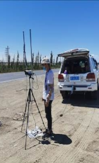
IV Networking of NSIN
| Location of airship | Location of receiver | Distance (km) | Packet loss rate | Latency (ms) |
|---|---|---|---|---|
| (41.412629∘,88.167300∘) | (42.275686∘,87.076372∘) | 132 | 0% | 3.656 |
| (41.558200∘,87.975700∘) | (41.849713∘,86.329568∘) | 141 | 0% | 3.688 |
| (41.627400∘,87.817200∘) | (41.834235∘,85.923380∘) | 159 | 0% | 3.676 |
| (41.685900∘,87.662700∘) | (41.947432∘,85.409625∘) | 190 | 0.029% | 3.997 |
| (41.845100∘,87.541100∘) | (42.006960∘,84.597780∘) | 245 | 0.05% | 4.132 |
| (41.987700∘,87.503637∘) | (41.825335∘,83.861625∘) | 302 | 0.08% | 4.167 |
| (41.880320∘,87.542650∘) | (41.825335∘,83.861625∘) | 306 | 0.12% | 4.525 |
In this section, we elaborate on the networking approaches for NSIN, mainly from the perspectives of constructing and managing NSIN.
IV-A Deployment of NSIN
IV-A1 QoS-driven NSIN deployment
The deployment locations of airborne platforms in NSIN greatly affect the QoS of served users. For instance, we conducted an experiment to test the coverage performance of a communication system onboard our airship, as shown in Fig 16. Table IX summarizes test results. The experimental results show that users at the edge of the HAP footprint will experience a high packet loss rate. Therefore, it is essential to investigate the QoS-driven NSIN deployment problem. QoS-driven NSIN deployment refers to the optimization of the deployment locations or trajectories of aerial platforms in NSIN based on space-time distributions of serving users in a considered area, the goal of which is to meet the users’ QoS requirements. Typically, users’ QoS requirements can be characterized as their received signal-to-noise ratio (SNR) or achievable data rates [109]. Nevertheless, it is difficult to solve the QoS-driven NSIN deployment problem. First, NSIN consists of multiple sub-networks deployed at different altitudes. The sub-networks have many differences in capabilities, such as payload, communication, and maneuverability. Therefore, studying the QoS-driven NSIN deployment problem means a solution of a joint optimization and deployment problem of a stereoscopic, multi-layered, heterogeneous network. Secondly, the airspace environment in which NSIN are deployed is complex and constantly changing. The airspace needs to be shared by the aerial platforms of NSIN and civil aviation aircrafts. There are also many unknown and uncertain risk areas in the airspace. Therefore, studying the QoS-driven NSIN deployment problem needs to explore how to ensure the flight safety of aerial platforms. To meet the above challenges, it is first necessary to mathematically model the stereoscopic, multi-layered, and heterogeneous characteristics of NSIN. A feasible approach to reflecting the stereoscopic and multi-layered characteristics of NSIN is to define different coverage or footprints for various platforms, design a time-varying sub-network selection scheme, and establish a multi-category signal interference regime. In order to characterize the heterogeneity of aerial platforms, a viable method is to constrain the service capabilities of platforms from the perspective of limiting available computing, storage, and network resources. Additionally, it is necessary to plan offline or online trajectories for NSIN platforms by detecting the surrounding environment. Next, formulating and solving the NSIN deployment problem to meet the user’s QoS requirements, subject to the constraints on the stereoscopic, multi-layered, and heterogeneous characteristics and the flight safety requirement. The formulated optimization problem is typically a multi-objective, multi-constrained, high-dimensional, and serialized decision-making problem. Therefore, it is challenging to use traditional optimization approaches to obtain the optimal or sub-optimal solution. Instead, intelligent optimization, reinforcement learning, and graph neural networks are better approaches to solve this type of problem.
![[Uncaptioned image]](/html/2310.09025/assets/x25.png) |
The QoS-driven NSIN deployment problem is currently under active research, and a number of related studies have been published in the literature during the past few years [110, 111, 112, 113, 114, 115, 116, 117, 118, 119, 120, 121, 122, 123, 124, 125]. Table X summarizes the recent studies on the QoS-driven NSIN deployment problem in the literature. For instance, the work in [110] formulated a HAP constellation deployment problem with a goal of maximizing the network capacity under the constraints on QoS metrics that were characterized by the efficiency and reliability of communications. To efficiently search for deployment locations of HAPs, an improved artificial immune algorithm was designed. The works in [111, 112, 113] proposed to deploy a near-space communication system to meet the QoS requirements of ground users. The following problem was studied: how to strike a balance between the flying speed of a near-space platform and the good coverage for users subject to a complex distribution? The authors transformed the conflict between flying speed and coverage into a multi-objective problem and developed various multi-objective optimization evolutionary algorithms based on decomposition to solve this kind of problem. The issue of deploying a stand-alone HAP and multiple UAVs to provide communication coverage or partial computing services for ground users also attracts much attention from the research community [114, 115, 116, 117]. For instance, the authors in [114] designed an NSIN architecture to provide reliable communication services for terrestrial vehicles. In this architecture, vehicles would receive both signals directly from a HAP and relayed signals from multiple UAVs. To enhance the spectral efficiency and downlink transmission rate of NSIN, researchers investigated the joint design of non-orthogonal multiple access (NOMA) and UAV location optimization. Furthermore, in [118], the joint optimization of UAV trajectory and phase shift of RIS was studied to maximize the received SNR of terrestrial users. An alternative optimization algorithm was designed to optimize the UAV trajectory and adjust the RIS phase shift. In [119], researchers proposed a HAP deployment algorithm that aimed to maximize the ratio of the HAP footprint to the inter-HAP distance. The works in [120] designed a HAP-assisted wireless sensor network (WSN) architecture to reduce the energy consumption of sensors and boost the coverage of the WSN. A potential game approach was developed to determine the deployment locations of HAPs so that the above goal could be achieved. In [121], the deployment of HAPs for providing communication services to terrestrial users was formulated as a potential game. To identify the deployment locations of HAPs that could satisfy the QoS requirements of more users, a restricted spatial adaptive play learning algorithm was devised. The work in [122] investigated the methodology of HAP deployment to guarantee ground users’ QoS requirements.To optimize the locations of HAPs, an enhanced artificial immune approach based on immune review was developed. Additionally, the deployment scenario of a HAP system for quick communication recovery in a disrupted communication area was presented in [123]. To guarantee the QoS requirements of users in a given area, a machine learning-based propagation model was developed to optimize the deployment altitude of a HAP.
IV-A2 QoE-driven NSIN deployment
With the rapid growth of streaming services, it becomes increasingly important to focus on the subjective experiences of users. QoS metrics can only measure network performance and cannot reflect users’ subjective feelings about service quality. The concept of QoE was proposed to tackle this issue. QoE reflects the subjective feelings of users watching videos and becomes the main performance evaluation criteria for video service quality.
Research on QoE in wireless communications is a hot and under-studied topic. There is a consensus that a unified QoE evaluation model cannot be achieved. This is because different video applications have diverse requirements for video quality. For instance, short video applications focus on the opening rate per second, high-definition long video applications have stringent requirements for high bandwidth, video conferences, and online games pursue low latency and high smoothness.
However, it is widely accepted that users cannot accept three categories of feelings during video transmission, i.e., freeze, blur, and large delay. Therefore, some underlying layer and upper layer mechanisms need to be carefully designed so that users’ QoE requirements, including low latency, high video quality, and smooth playback, can be satisfied.
It is easy to know that the QoE evaluation indicators are subjective. In this case, one should analyze the relationship between users’ QoE and its influencing factors and establish a mapping model between them. For example, one can utilize the peak signal-to-noise rate (PSNR) to objectively measure the quality of demodulated videos. To objectively measure the smoothness of played videos, a viable approach is to design and optimize a logarithmic utility function that takes into account factors such as the user’s achievable data rate, desired playback rate, and application type. A typical smoothness measurement model can take the following form, , where , is the time-averaged data rate of user , represents the desired playback bitrate of user , represents the total bandwidth, and , are both positive values that are different for various types of applications.
It is not difficult to optimize a certain QoE evaluation indicator alone. Nevertheless, it is highly challenging to simultaneously optimize all the indicators owing to their mutual restrictions.
| Refs. |
|
|
|
Caching | MEC | Latency |
|
|
|
|
|
|
||||||||||||||||||
|---|---|---|---|---|---|---|---|---|---|---|---|---|---|---|---|---|---|---|---|---|---|---|---|---|---|---|---|---|---|---|
| [126] | ✓ | ✓ | ✓ | ✓ | ✓ | ✓ | ✓ | |||||||||||||||||||||||
| [127] | ✓ | ✓ | ✓ | ✓ | ✓ | |||||||||||||||||||||||||
| [128] | ✓ | ✓ | ✓ | ✓ | ✓ | |||||||||||||||||||||||||
| [129, 130] | ✓ | ✓ | ✓ | ✓ | ✓ | ✓ | ||||||||||||||||||||||||
| [131] | ✓ | ✓ | ✓ | ✓ | ✓ | |||||||||||||||||||||||||
| [132] | ✓ | ✓ | ✓ | ✓ | ||||||||||||||||||||||||||
| [133] | ✓ | ✓ | ✓ | ✓ | ✓ | |||||||||||||||||||||||||
| [134] | ✓ | ✓ | ✓ | ✓ | ✓ | ✓ | ||||||||||||||||||||||||
| [135] | ✓ | ✓ | ✓ | ✓ | ✓ | ✓ | ✓ | |||||||||||||||||||||||
| [136] | ✓ | ✓ | ✓ | ✓ | ✓ | ✓ | ||||||||||||||||||||||||
| [137] | ✓ | ✓ | ✓ | ✓ | ✓ | |||||||||||||||||||||||||
| [138] | ✓ | ✓ | ✓ | ✓ | ✓ | ✓ | ✓ | |||||||||||||||||||||||
| [139] | ✓ | ✓ | ✓ | ✓ | ✓ | ✓ | ✓ |
There have been limited methods for QoE-driven HAP deployment thus far. However, the research on QoE-driven UAV deployment has recently gained extensive attention. Table XI summarizes recent literature on QoE-driven UAV deployment. For example, the works in [126, 127, 128] proposed to minimize the video transmission latency by formulating and solving a UAV resource optimization problem. In [126], the authors addressed the issue of jointly optimizing computing offloading, UAV 3D trajectory, UAV transmission power control, and system bandwidth to maximize computation efficiency and guarantee users’ video transmission latency requirements. A latency-guided video delivery framework was proposed for cache-enabled multi-UAV networks in [127]. The authors studied the optimization problem of joint UAV and cache placement to minimize video delivery latency.
Different from [126, 127, 128], the works in [129, 130, 131, 132] proposed to optimize UAV resources to ensure smooth video playback. In [129, 130], a logarithmic function was used to model smooth playback utility with respect to video transmission rate. The authors investigated joint optimization of UAV transmit power, UAV trajectory, and system bandwidth to maximize the minimum utility among all users, subject to constraints on UAV total power and video playback. The work in [131] utilized the mean opinion score (MOS) to measure the smoothness of playback video. The authors proposed to leverage a hybrid deep reinforcement learning (DRL) approach to adjust UAVs’ moving directions and distances to achieve energy-efficient and smooth video playback.
Several works including [133, 134, 135, 136] investigated the joint resource optimization problem in UAV networks to ensure high-quality video reception by users. In [133], the authors studied the joint optimization problem of UAV trajectory and transmit power to maximize the minimum PSNR of users’ video reconstruction quality. An iterative optimization algorithm was developed, consisting of block-coordinated descent and successive convex approximation schemes, to solve the problem. The authors in [134] proposed a joint optimization approach to ensure the quality of received videos by users by optimizing user scheduling, UAV trajectory, UAV transmit power, and bandwidth. They developed an alternative optimization approach to solve the mixed-integer and non-convex joint optimization problem.
However, the above works [133, 134, 135, 136] did not investigate the trade-off among QoE indicators. To tackle this issue, the works in [137, 138, 139] investigated the joint optimization of QoE indicators. For instance, the work in [137] developed a UAV path planning scheme to deliver low-latency and high-quality videos to users. The authors in [138] formulated the QoE by considering three factors, including video quality, jitter between video frames, and video latency. They jointly optimized the video resolution, UAV trajectory, and UAV transmit power using the deep Q-network (DQN) and actor-critic approaches to maximize the QoE of real-time video streaming.
IV-B Handoff Management
The handoff (or handover) means the shift of communication services for a particular user from one platform footprint (i.e., cell coverage of a platform on the ground) to another.
Both the mobility of serving users and the instability and mobility of airborne platforms will trigger the handoff process. For instance, the movement and mechanical vibrations of airborne platforms, as well as the airflow in the troposphere and stratosphere, can cause changes in attitudes and locations of airborne platforms [140]. Fig. 17 shows the attitude changes of our airship caused by mechanical vibrations and sudden airflow over two days. From this figure, we can observe that the pitch and the roll angles can vary up to 3.3∘ and 1∘. Besides, Fig. 18 shows that sudden airflow has a significant affect on the yaw angle of airship, and the change is more than 5∘. Consequently, the locations or shapes of cells may also change, as illustrated in Figure 19.
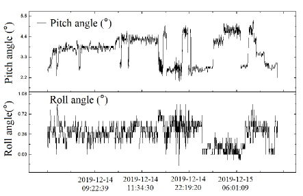
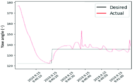
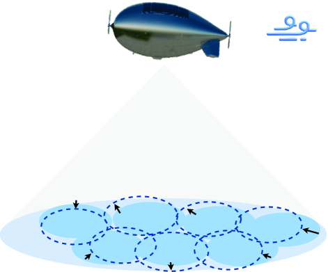
Nevertheless, there are some differences in terms of the handoff frequency for users in the footprints of airborne platforms. The handoff frequency is influenced by various factors, including the distribution of users (e.g., inner users vs. edge users), the speeds of both platforms and users (slow vs. fast), the coverage area of platforms (large vs. small), and the status of platforms (e.g., normal vs. abnormal operation). For instance, unstable platform movements will greatly increase the handoff probabilities of edge users in a footprint.
Handoff types can be categorized into two groups: hard handoff and soft handoff. In the case of a hard handoff, the session established by an old network is terminated before it is re-established by a new network. The situation is opposite in the case of a soft hand, where the session is maintained by the new network before the old network breaks the session.
Besides, the handoff can be horizontal or vertical. Horizontal handoff indicates the mitigation of a session from one footprint to another in the same network. On the contrary, vertical handoff refers to the seamless transition of a session between two heterogeneous networks.
The handoff process results in the mitigation of state information and PHY layer connectivity from one footprint to another. Specifically, the handoff process consists of three phases: footprint discovery, trigger, and execution phases. During the footprint discovery phase, a user actively sends probes or passively listens to broadcast service advertisements to discover several footprints on assigned channels. According to the discovery, the user establishes a list of candidate footprints prioritized by handoff criteria (e.g., received signal strength (RSS), carrier-to-interference ratio (CIR), congestion status, and surveillance information). During the trigger phase, the decision to initiate a handoff is made based on various criteria, such as sub-network rental fees, SNR, handoff latency, elevation angle, and the availability of free channels. During the execution phase, the inter-footprint mitigation of sessions takes place, ensuring the seamless transfer of all contextual information related to the user.
A well-designed handoff algorithm is essential to reducing the overhead (e.g., session interruption, packet loss, handoff latency) of the handoff process [141]. Therefore, we highlight some of the key handoff management strategies developed for NSIN in the literature, the classification diagram of which is summarized in Fig. 20.
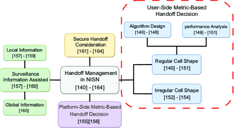
One of the significant goals of handoff algorithms is to ensure that the disruption experienced by users during handoff is imperceptible. Recently, a large number of methods have been introduced in the literature for reducing the overhead during the handoff process [140, 141, 142, 143, 144, 145, 146, 147]. For example, the work in [140] investigated the horizontal handoff between footprints served by the same HAP and the important problem of controlling which footprint to switch to at which time. With the aid of the measured RSS/CIR, a low-latency handoff algorithm was proposed. In this algorithm, a time-reuse time-division multiple/time-division multiple access (TDM/TDMA) frame structure was exploited. To maintain transparency in the handoff process for users, a single-frequency variant was proposed in which the HAP transmitted to or received from different spot beams (i.e., footprints) in various parts of the frame.
Handoff algorithms with a fixed RSS/CIR threshold, however, could not effectively tackle the handoff issues in a HAP network. This is because the HAP is usually in a quasi-stationary state, and the RSS of cell edge users in the HAP will dynamically change. As a result, the fixed threshold setting will cause frequent handoffs between cells. To address this issue, the work in [148] proposed an adaptive handoff algorithm to trigger the handoff according to predicted RSS by an improved least mean square (LMS) scheme. It was shown that the adaptive handoff algorithm could significantly reduce the unnecessary handoff time and keep the handoff failure probability at a lower level.
Except for developing some schemes to manage the handoff, many researchers have paid much attention to the analysis of the impact of airborne platforms’ unstable movements on the handoff probability [149, 150, 151]. For instance, the swing angle changes rapidly and unpredictably, making it challenging to adjust the parameters and orientations of airborne antennas in real-time to mitigate the impact caused by the swing. To this end, the work in [149] discussed the swing state of a HAP, analyzed the impact of the swing state on the handoff, and derived the average and maximum handoff probabilities. A novel HAP swinging model based on fixed angle beamforming was proposed in [150]. Owing to the platform swing, the so-called “Ping-Pong handoff” would happen. Then, the authors analyzed the impact of platform swing in two cases: 1) all users executed the handoff immediately when the swing happened; 2) all users refused to handoff (if triggered) to avoid the “Ping-Pong handoff”. Furthermore, in [151], the issue of yaw shift of HAP was addressed, and its influence on handoff was examined. A formula was derived to calculate the number of handoff calls, which indicated that various factors such as users’ density and location distribution in the cell, HAP’s yaw angle, cell geometry, and the number of active calling users could impact the number of handoff calls.
In the above studies [140, 141, 142, 143, 144, 145, 146, 147, 148, 149, 150, 151], a simple coverage model such as the circular and regular hexagonal coverage was introduced to mathematically analyze the handoff. While the mathematical analysis is simplified, it poses challenges to validating the derived conclusions in practical engineering scenarios. Therefore, some handoff algorithms based on irregular or inconsistent cell shapes were developed [152, 153, 154]. The work in [152] proposed a smart cell shape design for handoff management in a HAP network. Using user distribution and behavior data, the smart network design divided the coverage area into smaller spots and synthesized the desired cell by grouping some of these spots together. Consequently, the frequent handoffs from moving users could be significantly reduced. To investigate various issues related to the horizontal HAP handoff process, the work in [153] designed inconsistent footprint shapes for users locating at different positions of the service area using directional antennas. Based on the results, it was found that a wide beam-width antenna was suitable for serving users located in the center of the service area, whereas users located at the edge of the service area would benefit from a narrow beam-width antenna. To address the frequent handoff issue caused by the user movement as well as the unstable HAP movement, an adaptive handoff scheme with an overlapped footprint design was developed in [154]. Particularly, this paper utilized the mechanism of cooperative transmission between two HAPs to guarantee the QoS requirements of users at the edge of the coverage area. To improve transmission reliability, the HAP with a higher channel gain was selected for cooperative transmission. Additionally, handoff decisions were made based on the user’s movement direction and channel gain to minimize session interruption time caused by frequent handoffs.
In the above studies [152, 153, 154], single-metric (e.g., RSS/CIR) or user-side multi-metric (e.g., user distribution and user movement direction) handoff decision algorithms were designed. However, the metrics on the airborne platform side play a crucial role in the handoff decision-making process. For instance, when multiple users make handoff decisions simultaneously, solely relying on the RSS-based handoff algorithm can lead to HAPs with high RSS overload and HAPs with low RSS idle, potentially causing load imbalance within HAP networks. This, in turn, can result in network congestion and packet loss. Therefore, some handoff algorithms considering metrics on the airborne platform side were designed [155, 156]. For instance, a load-balancing handoff algorithm considering both the RSS of users and the residual energy of HAPs was developed in [155]. To minimize handoff failures during changes in network traffic load, a fuzzy channel allocation scheme was introduced in [156]. This scheme employed a guard channel policy and dynamically adjusted the optimal number of reserved channels based on QoS parameters. By efficiently allocating channel resources, the scheme prioritized ongoing calls over new calls.
Diverse from the above handoff schemes, local and global surveillance information collected by airborne platforms was utilized to assist the handover decision-making in [157, 158, 159]. Particularly, to decrease handoff frequency, local information such as the broadcast location, velocity, and flying direction of the airborne platform was leveraged to predict its flight trajectory. A global information-supported machine learning (ML) method could effectively predict future traffic loads, and then a joint decision on handoff and resource allocation could be made. Additionally, in order to ensure uninterrupted UAV connectivity within an NSIN-integrated network, a predictive decision algorithm based on global air control information and a handoff strategy were devised in [160]. Leveraging the global air control information, the predictive algorithm determined available access points for UAVs to establish new links or recover from old links in future time slots. Complementing the predictive algorithm, the handoff strategy seamlessly maintained UAV connectivity by transitioning among soft handoff, tracking hard handoff, and non-tracking hardoff states based on the predictive results.
However, the important issue of secure handoff was not investigated in the above studies. Some recent studies discussed the secure access authentication issue in the handoff process [161, 162, 163, 164]. Ensuring fast and secure handover is crucial for maintaining seamless coverage of NSIN over a wide area. The work in [161] investigated the optimization of the handoff latency with a given security requirement in an NSIN-integrated network. A new handoff approach that utilizes pre-authentication and security context transfer was suggested. The proposed scheme distinguishes between two types of handoffs: intra-domain and cross-domain. In the case of intra-domain handoff, the user only needs to initiate an application to the controller. However, for cross-domain handoff, the user must initiate an application to the management center, which involves saving all relevant information related to the NSIN-integrated network. To reduce the handoff latency while ensuring security, some temporary proxy certificates were transferred in advance. Meanwhile, to overcome the shortcomings of large handoff latency because of security requirements, the operations of platform trajectory prediction and pre-authentication were proactively performed based on periodically updated network status information. The authors in [162] also developed a secure and lightweight access authentication scheme for handoff management in an NSIN-integrated network. To minimize authentication delay and signaling overhead during the handoff process, the access authentication scheme for re-authentication message transmission adopted a multicast communication mode. The authentication process consisted of three phases: initialization, registration, and multicast authentication. In the initialization phase, to reduce the handoff latency, the handoff sequence was assigned in advance according to the proxy authentication center (PAC) coverage area. In the registration phase, to reduce the handoff latency caused by the configuration of link local addresses between users and PACs, different PACs would maintain the same link local unicast address. During the authentication phase, a multicast authentication method was employed to minimize the number of unnecessary access authentication messages.
IV-C Network Management
The recent studies on NSIN network management can be classified into network topology management and integrated network management. A summary of the corresponding management approaches is presented in Table XII.
![[Uncaptioned image]](/html/2310.09025/assets/x30.png) |
IV-C1 Network topology management
Compared to space networks and TN, NSIN possess distinctively dynamic connections and topologies. For example, the flight trajectories of some platforms may be random in a 3D airspace, resulting in intermittent and unpredictable connections. The operational duration of flight platforms in NSIN is significantly shorter compared to network nodes in space networks and TN. In this case, NSIN should be resilient to the dynamical topology to sustain service provision. Besides, as en essential component of 6G networks, NSIN should be designed to efficiently support multiple types of traffic concurrently. Adopting self-organization mechanisms holds promise for NSIN to be resilient to topology changes and adapt to distinct service requests. These mechanisms encompass self-configuration, self-healing, self-optimization, and self-protection functions. Self-configuration indicates the automatic recognition and registration of new neighbor nodes. Self-healing mechanisms in NSIN automatically address node failures and connection interruptions, ensuring uninterrupted services or mitigating service degradation. Additionally, self-optimization mechanisms automatically optimize the technical parameters of nodes to achieve specific objectives. Finally, to ensure network security and data confidentiality, the self-protection automatically protects NSIN from penetration by unregistered users. Let’s illustrate the aforementioned process with an example. When a new node emerges or an existing node fails, neighboring nodes undergo a neighbor discovery process to acknowledge this change. Network modifications trigger a series of message exchanges among nodes to reorganize the network. The next step is the connectivity establishment of nodes during self-organization by executing connection mechanisms in the PHY and upper layers. After establishing the connections, the service recovery process will be performed to recover from local service disruptions. Meanwhile, some optimization schemes, such as energy optimization, will be implemented to implement network and service optimization.
However, the task of designing dependable and effective self-organization functionalities in NSIN is challenging. The processes of self-organization require frequent measurements and probing. Then, the important issue of the trade-off between the optimality of self-organization and the signaling cost should be investigated. Incomplete, delayed, or even erroneous feedback may happen, which may significantly impact the efficiency of self-optimization processes and the service performance of the re-organized NSIN. Meanwhile, ultra-reliable self-organization functionalities in NSIN should be designed to minimize or avoid human intervention.
Some endeavors have been made to ease the design of self-organization functionalities in NSIN [165, 166, 167, 168]. For example, considering the unprecedented abilities of RIS in terms of enhancing spectral efficiency, coverage expansion, and security enhancement, the work in [165] proposed to utilize RIS technologies in NSIN-integrated air-space networks. With the utilization of RIS, the quality of inter- and intra-layer communications was improved, and the job of heterogeneous network self-organization was eased [165].
By utilizing RIS to program the dynamic RF environment, the traditional concept of cell boundaries could also be disrupted. Airborne platforms can be configured as airborne-RISs to extend service coverage. Link disruption caused by interference can also be mitigated by airborne-RISs. By analyzing a time sequence link weight graph, the authors of [166] developed a link fault recovery approach that targeted the unstable inter-domain neighbor relationships, frequent routing updates, and slow routing convergence issues in an NSIN-integrated space-ground network.The key idea of this approach was to dynamically choose backup links and search for a recovery path with the shortest length and the maximum path weight based on backup links when the link failure occurred.
AI/ML techniques can also be explored to effectively tackle the important issues in the self-organized NSIN. Deploying multiple HAPs as a network can greatly boost communication coverage. However, the construction of HAP networks is technically and economically challenging. The proposal for network self-organization aims to eliminate the need for direct human intervention and reduce operational costs. The work in [167] then applied reinforcement learning (RL) and swarm intelligence approaches to solve the self-organization and coordination problem of multiple HAPs for communication coverage. The work in [168] investigated the coordination of multiple self-organizing HAPs in a volcanic cloud emergency scenario for communication coverage. To coordinate a swarm of HAPs, a swarm intelligence-based algorithm was developed. This algorithm comprised different modes, including scouting mode, exploitation mode, decision loop, and main exploitation mode. Similar to a foraging behavior, the participating HAPs exchanged vital information as they explored the environment. The HAPs achieved persistent and resilient communication coverage by exchanging critical information and utilizing swarm techniques. The swarm’s resilience was tested by simulating the failure of a participating HAP.
IV-C2 Integrated network management
As mentioned above, NSIN are a type of heterogeneous, stereoscopic, multi-tier, and time-varying networks. Different frequency bands may be allocated to diverse sub-networks (or network segments), and the capabilities (e.g., communication, computing, and storage) of airborne platforms in different sub-networks are heterogeneous; thus, the communication system of a specific sub-network may be separate from other sub-networks. The separation of sub-networks will significantly limit the reconfigurability and interoperability of NSIN and greatly increase network management costs and complexity.
Exploring the concepts of software and virtualization, software-defined networking (SDN) and network function virtualization (NFV) techniques can redefine the NSIN architecture to tackle some challenges in NSIN, including inconsistent air interfaces and complicated heterogeneity, as well as reduce the management costs and complexity of NSIN. Furthermore, the flexible integration of sub-networks in NSIN can be greatly enhanced by leveraging SDN and NFV techniques. These techniques enable advanced network management strategies, promote business agility, and facilitate service innovation.
On one hand, SDN facilitates centralized control in the data plane by decoupling the controller from the switch. This grants the controller a comprehensive overview of NSIN and enables the global management capability. In the data plane, SDN-enabled platforms will receive instructions from the centralized controller and do not need to understand diverse protocols. In this way, the flexibility of managing these platforms can be significantly improved.
On the other hand, NFV can implement various network functions through visualization technologies and decouple network functions from proprietary hardware devices. Thus, the dispatching of network functions as instances of common software to service providers breaks through the barriers created by dedicated hardware devices.
Fig. 21 illustrates an SDN- and NFV-based network management framework of NSIN for providing flexible network services. In this framework, the data flow needs to flow through a sequence of virtualized network functions (VNFs) to implement a specific service. Different network services such as business management, session management, mobility management, access control, service multiplexing, and coverage maintenance can be implemented by diverse service function chains (i.e., sets of ordered virtual functions with logical dependencies).
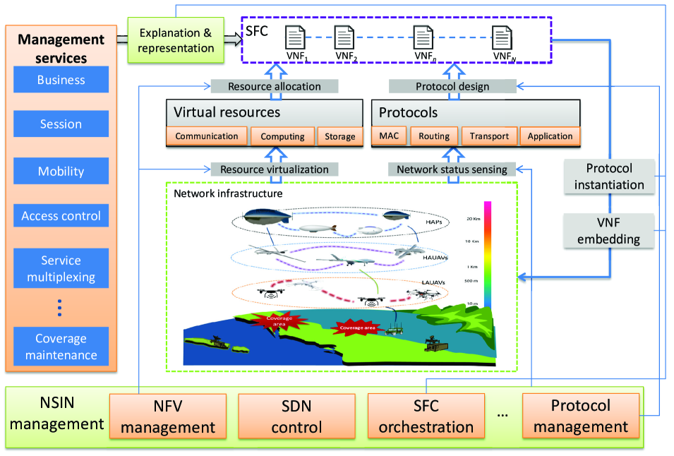
By exploring the concept of NFV, heterogeneous resources from diverse sub-networks can be extracted into unified virtual resource pools for flexible resource management, orchestration, and allocation. Separating the data plane from the control plane enables the SDN controller to design efficient network protocols and issue instructions for SDN-enabled platforms. This type of framework enables flexible network reconfiguration, dynamically adapting network service provisions to changing service requirements. When service requests change or the capability of network service provisions changes (due to dynamic network topology), reconfigured services can be easily implemented by updating software or the sequence of VNFs.
Recently, many promising SDN and NFV solutions have been developed to manage the integrated NSIN [143, 169, 170, 171, 172, 173, 174, 175, 176, 177, 178, 179, 180, 181]. In [169], an SDN- and NFV-enabled system architecture consisting of infrastructure, control, and application layers for NSIN-integrated network management was designed. In the infrastructure layer, some airborne platforms acted as SDN-enabled switches or gateways to forward data packets based on flow tables. The infrastructure entities in each sub-network were virtualized, and VNFs were deployed on demand. In the control layer, both master SDN controllers and slave SDN controllers were configured to effectively manage the network. The master SDN controller collaborated with its slave counterparts to gather the global network status and oversee the entire network topology for resource management at a high level, while the slave SDN controllers undertook fine-grained resource management tasks. The application layer would provide diverse programmable services and management modules through some interfaces. The resource request issues of the application layer would be interpreted by the interfaces into the instructions of SDN controllers. In [177], an SDN/NFV-enabled NSIN-integrated network management architecture was developed. To realize the SDN/NFV-enabled architecture effectively, the crucial issues of the design of gateway deployment policies, the optimal placement of SDN controllers, the embedding of service function chains, and the establishment of traffic routes between these chains were investigated. In [182], an integrated NSIN hierarchical network architecture was proposed for beyond 5G (B5G) wireless networks. In this architecture, a centralized SDN controller was embedded to manage the operation of the whole NSIN and incorporated the cross-tier sub-networks at the upper level. Three separate SDN controllers in the lower layer were embedded into sub-networks for local network management (or fine-grained management). In [183], an SDN-enabled NSIN-integrated network architecture was developed for network management. Particularly, the optimal placement strategy of an SDN controller for dynamic network topology management was studied. Besides, an SDN/NFV-enabled NSIN-integrated network architecture was proposed in [178] to implement unified network management and dynamic device configuration. In the NSIN-integrated network, SDN controllers were deployed to create SDN tunnels in the core network, and VNFs were deployed in the clouds to enhance network flexibility and reliability.
IV-D Summary and Discussion
The deployment of NSIN is task-driven, and therefore, NSIN should be deployed to satisfy the QoS and QoE requirements of tasks. It is essential to formulate the NSIN deployment problem as an optimization problem. However, this type of optimization problem is hard to formulate due to the multi-layered and heterogeneous network structure as well as some restrictions on the flight airspace and the platform itself. Therefore, great efforts should be spent in the processes of modeling of problem constraints with consideration of network characteristics, and novel approaches are desired to be designed to solve this type of problem effectively. In this section, we discuss the existing works on QoS- and QoE-driven NSIN deployment in detail, which may shed light on the comprehensive modeling of NSIN deployment problems. Handoff has a significant impact on the service performance of NSIN, especially for users located near the boundaries of NSIN footprints. We explore the primary reasons for handoff among NSIN-covered users, summarize the impact of handoff frequency, and survey recent advancements in addressing handoff issues. We discuss the network management of NSIN from the perspectives of network topology management and integrated network management. Specifically, we provide detailed explanations of the procedures involved in network self-organization mechanisms for topology management, and we provide an overview of network architectures for integrated network management based on SDN and NFV. Based on our research on NSIN deployment, handoff management, and network management, we can conclude that situational information, which includes security situations and network situations, is crucial for designing effective networking approaches. Yet, the research on situation-assisted NSIN networking is still in its initial stage, and the accurate perception of situations in NSIN is challenging. For instance, there are a large number of small threat targets without obvious features, which makes it difficult to detect them in time and accurately. Owing to its stereoscopic, multi-layered, and heterogeneous characteristics, it is highly challenging to estimate the link budget and network capacity of NSIN. Nevertheless, potential improvements in network resource utilization and energy efficiency make it worthwhile to pay more attention to situation-assisted NSIN networking.
V Transmission via NSIN
In this section, we overview the design of key technologies in the PHY layer, MAC layer, network layer, and transmission layer that aim to solve the effective transmission issue in NSIN.
V-A PHY Layer
Fig. 22 shows a logical diagram of the digital signal processing module designed for communication systems of our airship. In this PHY layer module, many techniques have to be studied, and beamforming is one of the most significant techniques. The purpose of beamforming is to implement efficient coverage by electronically controlling the amplitudes and phases of the weights of antenna array elements. It can be divided into active beamforming and passive beamforming. Table XIII describes the main ideas, pros, and cons of different types of beamforming techniques.
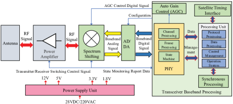
![[Uncaptioned image]](/html/2310.09025/assets/x33.png) |
V-A1 Active beamforming
Active beamforming array is an architecture where RF amplifiers are utilized as internal elements of an antenna array. According to the hardware structure of the antenna array, the active beamforming architecture can be classified into digital beamforming, analog beamforming, and hybrid beamforming.
Digital beamforming: For the digital beamforming architecture, as shown in Fig. 23, all operations (e.g., precoding, multiplexing, signal weighting, phase shifting) are performed in the digital domain. At the transmit end, amplitudes and phases of digital signals can be simultaneously and flexibly adjusted.
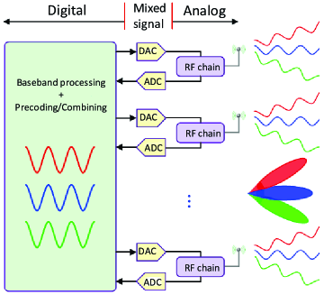
In digital beamforming architecture, each antenna element has a dedicated RF chain, enabling a variable number of beams based on the number of elements forming the beam. Additionally, all beams can be steered, and algorithms can synthesize a drive signal to optimize the desired characteristics of each beam. Owing to its high flexibility in producing beams, many digital beamforming methods for NSIN have been proposed in recent years [185, 186, 187, 80, 188, 73, 189, 186, 190]. For example, [185] introduced a digital beamforming method that combined horizontal and vertical adjustments to address the displacement of HAP cells projected on the ground due to variations in stratospheric wind or turning flight. The work in [186] investigated the interference mitigation problem in NSIN by optimizing beamforming vectors of HAPs and formulated this optimization problem as second-order cone programming, which was solved by an interior-point method. Besides, the work in [187] studied the digital beamforming for HAP multiple-input multiple-output (MIMO) systems and derived a beamformer matrix according to the critical observation that signal power concentrated on a statistical eigenmode instead of a statistical correlation matrix. However, the digital beamforming architecture increases digital chip content and the corresponding cost and power consumption.
Analog beamforming: As illustrated in Figure 24, the analog beamforming architecture incorporates a phase shifter at each antenna element, allowing for flexible and adaptive beams that can be directed in any direction. All phase shifters share a common RF chain in this type of architecture; as a result, analog beamforming is power- and cost-efficient. The authors in [191] investigated the problem of analog beamforming to achieve low power consumption and exploited the benefits of beamforming in HAP-based multi-user MIMO communication systems. They formulated the analog beamforming problem as quadratically constrained quadratic programming and proposed a semi-definite relaxation approach to solve it. In [192], the authors investigated how to control the beam directions of the antenna onboard a HAP with consideration of the position of a ground gateway and attitude changes of a HAP. In [193], the authors proposed to optimize beamwidth and beam directions to prevent existing TN from being interfered with by a HAP. Besides, the authors in [194] studied the issue of HAP interference alleviation in HAP massive MIMO communication systems through user equipment beamforming. They proposed a semi-definite relaxation method to obtain the user equipment beamforming vector by maximizing its signal-to-pilot contamination ratio (SPR). However, the fine tuning of the beams in this type of beamforming architecture is limited due to the low resolution of quantized phase shifts.
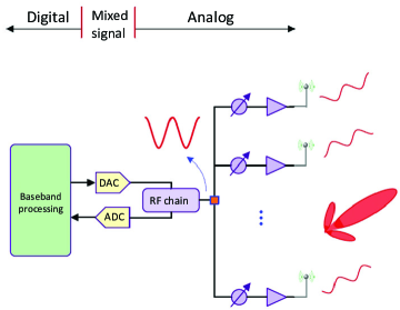
Hybrid beamforming: This beamforming architecture utilizes the advantages of both analog beamforming and digital beamforming architectures.
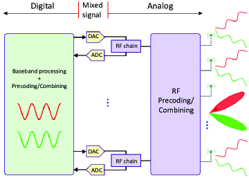
It employs precoding/beamforming at both RF and baseband, where the antenna elements are still driven by analog phase shifters, as shown in Fig. 25. Yet, the number of RF chains remains smaller compared to the number of antennas. The reduction in the number of RF chains and corresponding data converters results in less cost, computational load, and power consumption. Overall, this type of beamforming architecture strikes a trade-off between complexity and flexibility. As a result, it has garnered increasing attention from the research community. For example, the authors in [195] designed a hybrid beamforming scheme for HAP massive MIMO systems. Particularly, they derived the relationship between RF beamforming and statistical channel state information according to the duality theory and utilized the zero-forcing method to conduct baseband beamforming. The authors in [196] investigated the hybrid beamforming for HAP massive MIMO systems and formulated the RF beamforming as an average signal-to-leakage-plus-noise ratio maximization problem. A greedy algorithm was then designed to obtain the RF beamforming matrix. Given the RF beamforming matrix, the baseband beamforming matrix was obtained by a regularized zero-forcing method. The authors in [197] proposed to solve the high power consumption, high cost, and high hardware complexity issue of conducting hybrid beamforming for HAP massive MIMO systems. To this end, they designed an adaptive cross-entropy-based optimization method to update the RF beamforming matrix and employed a zero-forcing method to obtain a digital beamforming matrix. Besides, the authors in [198] developed a two-stage precoding scheme to alleviate the interference between HAPs. Particularly, the proposed scheme separately controlled the interference between HAPs and user-specific beams by factorizing the overall precoding weight matrix into an outer precoder for interference reduction and an inner precoder for user-specific beam generation.
V-A2 Passive beamforming
Beamforming architecture in which amplifiers or radios are used as external elements of an antenna array is known as a passive beamforming array. A typical passive beamforming pattern is RIS or IRS. In some scenarios, many aerial platforms of NSIN are expected to act as aerial relays. To complete the task of relaying signals, aerial platforms have two selections: 1) act as radio relays that mount active beamforming payloads; 2) integrate with RIS/IRS. When acting as radio relays, aerial platforms have to mount some payloads, such as antennas, analog-to-digital converters (ADCs), digital-to-analog converters (DACs), data converters, mixers, power amplifiers, and filters, entailing high hardware complexity and large energy consumption. On the contrary, RIS/IRS-mounted relays can be designed by coating the surfaces of aerial platforms with a thin layer of meta-surfaces, entailing low hardware complexity. Moreover, several studies have demonstrated that the capacity attained through RIS/IRS-mounted relays is comparable to that achieved through radio relays [199, 200]. Further, for NSIN, the energy consumption of using RIS/IRS is much lower than that of using radio relays [201, 202]. For example, using RIS/IRS reduces the communication energy consumption of NSIN to the required power for the RIS/IRS controller. In a recent experiment, it was found that the configuration of each reflector unit consumed 0.33 mW [203]. Studies have indicated that an RIS/IRS-assisted communication system could achieve a remarkable % increase in energy efficiency compared to a radio relay-assisted system [199]. Therefore, RIS/IRS-mounted relays will be a promising solution for NSIN to build multi-hop links in a cost-efficient way.
Actually, RIS/IRS are a planar array composed of a large number of passive reflecting elements. By precisely manipulating the phases and directions of incident signals in a controlled manner, the planar array enables passive beamforming, which intelligently reflects signals towards targeted directions using passive reflecting elements [12]. Mathematically, denote as the incident wave of the -th element of RIS/IRS. Then, the reflected signal can be written as , , where and control the amplitude and phase shift of the reflected signal, respectively, and denotes the total number of array elements.
Recently, the investigation of integrating RIS/IRS on different aerial platforms has attracted lots of attention in the research community. Table XIV compares the recent studies on aerial-RIS (ARIS). Summarily, the recent researches can be classified into three groups: channel modeling of ARIS [204, 205, 206, 207, 208], deployment or trajectory planning of ARIS [209, 210, 211, 212, 213, 118, 214, 215, 216, 217, 218], and performance analysis of ARIS [219, 220, 221, 222, 223, 224].
| Refs. | Amplitude |
|
|
|
|
|
|
|
|
|
|
|
|||||||||||||||||||||||||
| [204, 205] | ✓ | ✓ | ✓ | ✓ | |||||||||||||||||||||||||||||||||
| [206] | ✓ | ✓ | ✓ | ✓ | |||||||||||||||||||||||||||||||||
| [207] | ✓ | ✓ | ✓ | ✓ | |||||||||||||||||||||||||||||||||
| [208] | ✓ | ✓ | ✓ | ✓ | ✓ | ||||||||||||||||||||||||||||||||
| [209] | ✓ | ✓ | ✓ | ✓ | |||||||||||||||||||||||||||||||||
| [210] | ✓ | ✓ | ✓ | ✓ | |||||||||||||||||||||||||||||||||
| [211] | ✓ | ✓ | ✓ | ✓ | |||||||||||||||||||||||||||||||||
| [212] | ✓ | ✓ | ✓ | ✓ | ✓ | ||||||||||||||||||||||||||||||||
| [118] | ✓ | ✓ | ✓ | ✓ | ✓ | ||||||||||||||||||||||||||||||||
| [213, 214] | ✓ | ✓ | ✓ | ✓ | |||||||||||||||||||||||||||||||||
| [215] | ✓ | ✓ | ✓ | ✓ | |||||||||||||||||||||||||||||||||
| [216] | ✓ | ✓ | ✓ | ✓ | |||||||||||||||||||||||||||||||||
| [217] | ✓ | ✓ | ✓ | ✓ | |||||||||||||||||||||||||||||||||
| [218] | ✓ | ✓ | ✓ | ✓ | |||||||||||||||||||||||||||||||||
| [219, 220] | ✓ | ✓ | ✓ | ||||||||||||||||||||||||||||||||||
| [221, 224] | ✓ | ✓ | |||||||||||||||||||||||||||||||||||
| [222] | ✓ | ✓ | ✓ | ||||||||||||||||||||||||||||||||||
| [223] | ✓ | ✓ | ✓ | ✓ |
In terms of channel modeling of ARIS, for example, under the condition of considering the correlations of fading channels in the spatial, time, and frequency domains imposed by the AoA/AoD, the Doppler, and the orthogonal frequency division multiplexing (OFDM) operations, the channel modeling of high-dimensional and high-mobility ARIS was investigated in [204]. In [206], the cascaded channel estimation in full-duplex ARIS communications under the condition of varying channel characteristics was studied. For the channel estimation, a graph attention network was utilized. Under Rician fading conditions, a composite channel gain expression was proposed in [207]. Besides, considering the position perturbation of ARIS, a novel atomic norm minimization method was developed to estimate the direction of arrival (DoA) in [208].
In terms of the deployment or trajectory planning of ARIS, for instance, an optimization framework was formulated and solved in [209], which considered ARIS’s deployment, power allocation at a macro base station, phase shift of ARIS, and blocklength of ultra-reliable low latency communications (URLLC). The work presented in [210] investigated the optimization of ARIS’s horizontal position and phase shift of ARIS to maximize the rate of a strong terrestrial user while guaranteeing the target rate of a weak terrestrial user. In [212], the problem of optimizing ARIS beamforming and trajectory to enable reliable data transmissions from ARIS to an intended terrestrial user was explored. Furthermore, in [213], the objective was to maximize the minimum throughput among all mobile vehicles by jointly optimizing ARIS passive beamforming and trajectory, with the aim of achieving communication fairness.
In terms of performance analysis of ARIS, for example, the outage probability and ergodic spectral efficiency expressions of ARIS communications were derived by the probability theory in [219]. The impact of imperfect phase knowledge on the system capacity of ARIS communications was investigated in [220], where the phase error was modeled as a von Mises random variable. On the other hand, [221] derived tractable analytic expressions for the achievable symbol error rate (SER), ergodic capacity, and outage probability of ARIS communications. The tight upper and lower bounds of the average SNR were also derived. Besides, the work in [222] theoretically analyzed the link budget of ARIS communications for ARIS ‘specular’ and ‘scattering’ reflection paradigms.
V-B MAC Layer
The primary goal of MAC protocols is to improve network capacity and reduce packet transmission latency. MAC protocols greatly impact the performance of wireless networks, including network throughput, latency, and reliability. There are three categories of MAC protocols, which include fixed allocation protocols, random contention protocols, and reservation protocols.
Fixed allocation protocols needing to reserve network resources are suitable for wireless networks with stable topologies or associations, a delay-sensitive constraint, and regular traffic flows. Random contention protocols are suitable for wireless networks with random traffic flows, a delay-tolerant constraint, and time-varying topologies or associations. Reservation protocols are suitable for wireless networks with irregular and highly fluctuating traffic flows and time-varying topologies or associations.
V-B1 Fixed allocation protocols
Channel resources in this kind of MAC protocol are allocated or reserved to each node in wireless networks according to a certain allocation algorithm in advance. Many types of multiple access techniques, including TDMA, code division multiple access (CDMA), frequency division multiple access (FDMA), spatial division multiple access (SDMA), and NOMA, can be explored in fixed allocation protocols [225]. It is appropriate to apply fixed allocation protocols to the HAP sub-network in NSIN as a HAP is quasi-stationary and has a large footprint. Numerous relevant studies have been presented in the literature. For instance, the authors in [226] investigated the interference issue in a HAP and fixed wireless access (FWA) coexistence system. Under the TDMA assumption, they introduced a probabilistic model to analyze the aggregate interference caused by FWA transmitters for users served by the HAP. The paper [227] considered a HAP uplink communication scenario using a single-carrier FDMA (SC-FDMA) scheme. The investigation on the performance of a pilot-based uplink channel estimation method was conducted. The impact of some crucial coefficients, such as a user’s elevation angle, modulation scheme, LTE channel bandwidth, and Doppler shift, on a HAP uplink channel model was evaluated. The paper [228] designed a joint power control and space diversity algorithm to improve the performance of CDMA-enabled HAP communications at a low elevation angle. The authors in [229] studied the wideband CDMA (WCDMA) uplink capacity and the interference statistics of HAP macrocells using statistical geometry and probability theories. Exploiting beamforming to design SDMA-enabled HAP systems is currently under active research [230, 75, 76, 191, 231, 80, 187]. The work in [230] investigated the problem of augmenting ground communications through deploying an SDMA-enabled HAP. The authors in [75] considered a scenario of deploying a HAP to provide broadband infotainment services for vehicular users in rural areas and proposed to utilize steerable beam directional antennas to realize SDMA for vehicular users.
The investigation into the NOMA-enabled HAP networks has attracted much attention from the research community. The papers [114, 232] proposed the deployment of NSIN to provide reliable communication services to ground users, with the adoption of the NOMA technique to enhance the quality of downlink links for users located at the edge of NSIN. The paper [233] designed a novel secure transmission framework to provide latency-sensitive medical-care services for ground users by deploying a HAP and many low-altitude platforms. The authors proposed to deliver medical-care information to multiple hotspots via a NOMA transmission scheme and formulated an optimization problem for minimizing transmission latency, subject to power and spectrum constraints. An alternating optimization framework was designed to solve the optimization problem. The authors of [77] investigated energy-efficient beamforming for HAP-NOMA systems operating over Rician fading channels. Particularly, they derived the expression of the NLoS channel of a HAP equipped with a uniform planar array (UPA). Based on the obtained channel expression, a HAP-NOMA scheme, including user grouping and power optimization, was designed. The paper [234] considered clustered-NOMA NSIN and investigated the joint UAV location optimization and resource allocation problem to maximize the overall network uplink achievable rates. To solve this problem, UAV location optimization and resource allocation were iteratively performed. A simulation of HAP backbone networks utilizing the NOMA scheme was studied in [79]. The paper [235] considered an integrated HAP space information network using a NOMA scheme. The authors derived the closed-form expressions of the outage probabilities of the integrated network in the presence of imperfect channel state information (CSI) and successive interference cancellation (SIC). In [236], the authors discussed the issue of exploiting NOMA-based HAP communications and multiple antennas with user selection to meet the connectivity, reliability, and high achievable data rate requirements of users. In [237], the authors proposed to deploy a HAP communication system to enable NOMA for ground multi-cell users. The work in [238] theoretically analyzed the outage probability and ergodic capacity of a two-way satellite-HAP-terrestrial network with NOMA. Besides, in [239], the authors investigated the issue of deploying clustered-NOMA-enabled NSIN to cover remote areas where the clustered-NOMA technology was leveraged to achieve channel multiplexing and reduce the complexity of SIC.
V-B2 Random contention protocols
In this type of MAC protocol, each node in wireless networks accesses channels in a competitive way. Once obtaining the opportunity to access a channel, a node immediately accesses the channel or randomly accesses the channel with a certain probability after detecting that the channel is idle. If a packet collision occurs, the transmission fails, and the node chooses to back off and wait for the next transmission. The greater the number of transmission failures, the lower the random access probability. There are many famous random contention protocols, such as additive links on-line hawaii area (ALOHA), carrier sense multiple access (CSMA), and CSMA with collision avoidance (CSMA/CA). The ALOHA protocol utilizes the simplest random competition mechanism. Users access a channel immediately when they have data to send. In order to reduce collisions, users should avoid accessing the channel when the channel is not idle. For this purpose, the CSMA protocol has been developed. In this type of protocol, a user first monitors the channel before sending data, which thus reduces packet collisions to a certain extent. However, packet collisions may still happen due to propagation delays. To further reduce possible collisions, the CSMA/CA protocol is introduced. It adopts collision avoidance methods to reduce possible collisions. Specifically, it utilizes request-to-send (RTS) and allow-to-send control messages to implement channel reservation and collision avoidance, which thus improves the success probability of data transmission. For example, the authors in [240] adopted the CSMA/CA and RTS/clear to send (CTS) handshake mechanisms to solve the efficient access problem among a HAP and multiple UAVs when sharing channel resources.
V-B3 Reservation protocols
In this type of protocol, according to the amount of network traffic in a node, the node first competitively sends several short packets to reserve a channel in advance. This type of protocol mandates the exchange of reservation control information between nodes. As a result, a great deal of overhead will be generated when the payload in the networks is limited or the number of nodes varies. The impact of channel reservation information on channel utilization is a major concern for this type of protocol. The polling MAC protocol is a typical reservation protocol that maintains a central control node (or master) to centrally control each node’s access to the channel without contention.
Summarily, the random contention protocols and reservation protocols for dynamic networks can be applied to HAUAV and LAUAV sub-networks in NSIN.The HAUAV and LAUAV sub-networks are characterized by high mobility, which leads to fluctuating link quality and time-varying topologies. Nevertheless, the packet latency constraint is difficult to be satisfied in the dynamic HAUAV and LAUAV sub-networks. During the past few years, the problem of designing effective MAC protocols for UAV networks has been extensively studied in the literature. Table XV summarizes the surveys on UAV MAC protocols.
| Refs. | Focus | |||
|---|---|---|---|---|
| [23] |
|
|||
| [241, 242] |
|
|||
| [243] |
|
|||
| [244] |
|
|||
| [245] |
|
|||
| [24, 246] |
|
V-C Network Layer
A routing protocol aimed at tackling the issue of obtaining the most connected E2E path to reliably deliver traffic to one or more destination(s) with a reduced E2E latency. Considering the high heterogeneity and complexity of NSIN, it is highly challenging to design an efficient routing protocol to enable packet transmission across different network segments. Most existing routing protocols for UAV networks (partially) cannot be applied to NSIN. As noted in numerous surveys of UAV routing protocols, these protocols can be broadly categorized into topology-based routing protocols (such as flat, cluster-based, and hybrid routing protocols) and geographical routing protocols.
The topology-based routing protocol (exactly, flat routing protocol), including some famous protocols such as proactive, reactive, and hybrid routing protocols, cannot not be directly applied to route packets in NSIN. This is because all of these routing protocols assume that the nodes in the network have equal roles [247], which is not suitable for NSIN. The idea of adopting a greedy scheme and recovery scheme in UAV geographical routing protocols may be applicable for NSIN. However, the entire routing protocol cannot be directly applied to NSIN, mainly due to the large footprint of HAP as well as the long distance towards the destination. For instance, owing to its large footprint, a destination may always be in the coverage range of a HAP. Yet, owing to the high deployment altitude, the transmission distance of a UAV-HAP link is greater than that of a UAV-UAV link. Besides, for the geographic information-based routing protocols, they routed packets using the location information of airborne platforms and adopted a greedy scheme to forward packets. An important procedure in this type of routing protocol is that an airborne platform will deliver packets to a neighboring platform closer to the destination, and the routing process may fail if an invalid route occurs.
Therefore, routing protocols for NSIN should be separately designed. Existing routing protocols for NSIN can be categorized into two groups: HAP-assisted routing protocols and unified routing protocols. Table XVI compares the main ideas and some key performance indicators, e.g., signal overhead, communication latency, and packet delivery ratio, of these routing protocols.
![[Uncaptioned image]](/html/2310.09025/assets/x37.png) |
V-C1 HAP-assisted routing protocol
In this type of routing protocol, HAP networks are consistently utilized as a control information delivery layer. Specifically, HAPs can broadcast control information (e.g., automatic dependent surveillance-broadcast (ADS-B) and SDN information) that will be useful for the efficient protocol design of UAV networks. This type of protocol includes:
ADS-B system-aided Geographic Routing (A-GR) [248]: It is an ADS-B system-aided geographic routing protocol. ADS-B is a cooperative surveillance system for air traffic management (ATM). An ADS-B-enabled aircraft will broadcast a state vector including identification, position, velocity, altitude, and other flight-related information. Owing to their large footprints, HAPs are leveraged to expand the coverage of the ADS-B system. HAPs will collect ADS-B messages from different aircrafts and then broadcast this type of message.
A-GR differs from traditional routing protocols in that it builds a neighbor table using ADS-B messages instead of sending hello beacons, which reduces the beaconing overhead. Further, as the ADS-B system and the payload data transmission system adopt different antennas and frequency bands, ADS-B messages will interfere with payload packets. The update frequency of the neighbor table is determined by the ADS-B message cycle. A-GR designs a routing decision metric (i.e., instantaneous flight time, IFT) that considers the distance towards the destination and the relative velocities of airborne platforms. During the packet forwarding phase, a typical platform searches its neighbor table to determine the routing path for the packets. If multiple platforms are within its transmission range, the one with the best IFT is selected as the next hop. In the absence of platforms within the transmission range of the platform, the packets are buffered for a certain period of time until suitable platforms appear. If no suitable platform is found, the packets are dropped.
SDN-enabled approach [249, 250]: By providing an overview of NSIN and decoupling the control plan and data plan of the network, SDN can be deployed to design efficient routing protocols. For example, the authors in [249] proposed to deploy HAP-SDN controllers in NSIN and designed a traffic-differentiated routing (TDR) protocol according to information provided by these controllers. Specifically, in this protocol, HAP-SDN controllers were deployed to acquire a comprehensive abstract network view, facilitate unified scheduling of resources, and guide efficient data processing and delivery. Supported by controller-collected network state information (e.g., positions and speeds of UAVs, the number of successfully/unsuccessfully delivered packets, packet queuing delay, and transmission delay), an estimation of the availability of links in the near future was performed. The forwarding abilities of UAVs as well as packet delay on transmission links were predicted. Meanwhile, to address specific delay and reliability requirements of traffic flows, this protocol assigned different weights to flows based on their sensitivity to delay and level of importance. An optimization problem aiming to minimize the total cost of all traffic flows was then formulated and solved to update traffic routing paths. In SDN-enabled NSIN, however, the fast movement of UAVs may lead to long configuration update times in the data plane. In [250], the authors proposed to deploy a HAP-SDN controller to assist the design of a routing protocol for NSIN. Due to its wide coverage and relative stability, the configuration updating time could be reduced by HAP-SDN. The main functionalities of the controller include: 1) topology discovery, which involves perceiving and updating network topology in real-time as airborne platforms are added or removed from the data plane. 2) routing decision, which involves selecting the optimal routing path based on traffic distributions and QoS requirements within the integrated network.
V-C2 Unified routing protocols
Different subnetworks in NSIN may have diverse transmission capabilities and adopt different communication protocol formats and even communication system architectures. To achieve high efficient information transmission over NSIN, unified routing protocols are desired. When different communication protocol formats or system architectures are adopted, applying a number of gateways to interconnect subnetworks will be a feasible way. For example, we design an intelligent gateway routing protocol, its prototype and hardware device are shown in Fig. 26. It intelligently adapts the communication performance of subnetworks by dynamically adjusting the communication parameters of gateway routers to guarantee smooth video transmission in NSIN. Fig. 27 also shows the topology of the NSIN for real-time video transmission and the effects of video transmission.
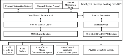
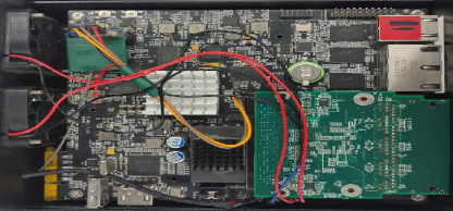
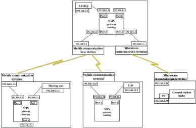

Except for gateway routing protocols, many other types of unified routing protocols have been designed with a consideration of the diverse transmission capabilities among different subnetworks, including:
Hybrid time-space Graph supporting Hierarchical Routing (HGHR) [251]: The work in [251] designed a unified routing protocol, HGHR, for space and UAV networks. Yet, HGHR can be deployed in NSIN. Similar to space networks, the topology of HAP networks is predictable.
HGHR is designed based on a hybrid time-space graph containing two subgraphs, i.e., a semi-deterministic subgraph for UAV networks and a deterministic subgraph for space networks. In the semi-deterministic subgraph, a UAV represents a node, and the weight of an edge is measured by UAV contact time and contact probability. The prediction of UAV contact time and contact probability is accomplished by utilizing a discrete time-homogeneous semi-Markov process with the state transition probability and sojourn time probability of each UAV as inputs. A deterministic subgraph for space networks can be constructed due to the predictable topology of space networks. By combining two subgraphs, a hybrid graph for the integrated networks is obtained. Under the hybrid graph, HGHR explores the store-carry-forward mechanism in a delay-tolerant networks (DTN) architecture to implement packet forwarding.
Greedy routing protocol [252]: The work in [252] proposed a greedy routing protocol for packet forwarding in NSIN-ground integrated networks. During the process of finding routes, this protocol allocated a higher priority to TN to fully utilize its computation resources and reduce resource utilization costs. When the E2E latency could not be guaranteed solely by TN, platforms in NSIN were considered to reduce the number of transmission hops. The protocol employed a greedy search approach to find the optimal route between a source node and a destination node, taking into account factors such as available bandwidth resources, transmission latency, and the level of function sharing requirements. Next, the route with the minimal total weights was selected. Finally, the protocol selected the most suitable nodes along the chosen route based on the available computation resources and the level of function sharing required.
Recurrent neural network (RNN)-based routing protocols [253]: The authors in [253] investigated the challenging issue of finding effective paths to deliver packets across a variety of network segments, including space networks, NSIN, and TN, using RNNs. Particularly, the long short-term memory network (LSTM) was explored to predict routes based on historical data. However, the training of neural networks is time-consuming. To address this problem, they investigated a coded technique that could alleviate the computational burden. By employing a coded computation model and selecting suitable machine learning network models, the training process could be accelerated through coding and computation offloading [254].
Reinforcement Learning-based Routing [255]: Considering that TN and NTN had different characteristics concerning bandwidth resources, energy resources, and transmission delay, the authors in [255] proposed an integrated space-air-ground routing protocol based on a RL approach. Specifically, they formulated a path selection optimization problem aimed at minimizing the transmission latency while considering the constraints on the remaining network energy and bandwidth. A Q-learning method was explored to solve this problem, and a penalty mechanism was activated when a platform had little residual energy and/or its bandwidth utilization was too high.
Ant Colony Optimization (ACO)-based routing protocol [256]: The authors in [256] designed an ACO-based routing protocol for space-air-ground networks. The routing protocol designed a routing metric by exploring information, including link quality, E2E latency, and queue length, and consisted of three phases: route search, link selection, and route maintenance.
In the phase of route search, a source node will broadcast forward ants to find new routes toward a destination if a route cannot be found in its routing table. Once the forward ants reach the destination, the destination will dispatch backward ants to inform the source node. During the process of route searching, ants will find multiple routes. In the phase of link selection, nodes on established routes will randomly select an effective link to deliver packets based on a link selection probability related to SNR and remaining pheromone concentration. During the routing maintenance phase, the source node regularly sends forward ants to the destination to assess the route quality. If a failure link is detected during monitoring, the forward ants will promptly return, and the source node will update the routing table.
V-D Transport Layer
The efficient design of transport layer protocols is a crucial and hot research topic in the research area of NSIN. Reliable transmission, congestion control, and flow control are three main responsibilities of the transport layer protocol of NSIN. Particularly, a transport layer protocol in NSIN must be designed to ensure reliable transmission. Certainly, as different types of applications may have diverse requirements for transmission reliability and latency, transport layer protocols should support diverse reliability levels for diverse vertical applications. Congestion control is a key function of the transport layer protocol. A congested NSIN will result in a decrease in the packet delivery ratio and an increase in the E2E transmission latency. Therefore, efficient congestion control mechanisms should be designed for NSIN to avoid data congestion. Besides, flow control is a crucial function of the transport layer protocol to tackle the possible overload issue at a receiver.
TCP is the most widely used transport layer protocol; however, the application of conventional TCP to NSIN faces many challenges: 1) TCP’s flow control relies on a framing mechanism, and the size of the congestion control window fluctuates continuously, making it unable to adapt to the changing network topology. Additionally, accurately estimating the round-trip time (RTT) remains a challenging issue. 2) TCP will suffer from significant performance degradation mainly due to the frequent handover in NSIN; 3) besides, complex network structures, inconsistent communication protocols, and incompatible network equipment greatly degrade the performance of conventional TCP when applying in NSIN.
As a result, during the past few years, researchers had attempted to improve TCP or design new transmission control protocols following different design routes. Generally, the existing transmission control protocols in NSIN can be classified into three groups: improved TCP-based, scalable traffic control-based, and resource optimization-based protocols. Table XVII summarizes the main ideas and main pros and cons of these protocols.
![[Uncaptioned image]](/html/2310.09025/assets/x42.png) |
Improved TCP-based protocol: To tackle the issues of applying a TCP in NSIN, researchers have made some improvements by considering the distinctive features of NSIN, which makes it more appropriate for NSIN applications.
For example, the authors in [257] proposed a new TCP for satellite-HAP networks to support high-speed data transmission. Unlike the conventional TCP congestion control mechanism that utilized the standard additive increase multiplicative decrease approach to adjust the size of the congestion window, they classified the network congestion status into congestion status and non-congestion status. Based on different network congestion statuses, the authors designed a more aggressive congestion window size increment or decrease mechanism. The work in [258] developed a fountain code-based multipath transport protocol for NSIN. The protocol utilized the fountain code to improve the probability of successfully decoding packets. Considering the possibility of establishing multiple independent paths via diverse network interfaces onboard NSIN platforms, the authors proposed to deploy an independent TCP congestion control mechanism for each path. Through transmitting valid packets and ACKs via different paths, the congestion issue caused by the link capacity asymmetry was well addressed. The improvement of TCP for a HAP network was also investigated in [259]. In particular, the improved TCP involved three new mechanisms: 1) a relay node detecting the network congestion would send congestion messages to the source to achieve rapid congestion notification; 2) distinguished the reasons that resulted in the packet loss to avoid decreasing TCP throughput by mistake; 3) designed different congestion window adjustment schemes to adapt to the types of traffic.
Scalable traffic control-based protocol: By deploying programmable network devices or using the SDN technique, this type of control approach aims to improve the flexibility of traffic transmission control in complex and heterogeneous NSIN.
To adapt to the transmission requirements of large-scale space-air-ground integrated networks (SAGINs), the authors in [260] proposed a dynamic handover software-defined transmission control that supported heterogeneous users over SAGINs. Particularly, they explored the SDN technique to increase the data forwarding efficiency and implement the network platforms’ versatility by separating the control and switch functionalities of SAGINs. They also utilized a queued game theory to model the SDSAGINs’ transmission control problem and determined the transmission strategy by maximizing the social welfare of the queued game theory.
The work in [261] designed a traffic control-empowered satellite-HAP network architecture. In this architecture, the deployment of programmable satellite-HAP network nodes allowed for the utilization of telemetry functions and dynamic probes to gather network status information, such as link utilization and network congestion, and monitor network events, including congestion information and handover errors. Upon the arrival of a probe at a destination node or when the transmission hops of the probe reached a limit, feedback signals carrying local congestion information or other network statuses were generated and transmitted back to the source node. These feedback signals were then utilized to adjust network policies, such as sending rates or sub-network switching.
Resource optimization-based protocol: The primary concept behind this type of control protocol is to address congestion alleviation by formulating and resolving a network resource optimization problem.
The work in [262] studied the congestion control issue in a HAP-reserved SAGIN. Initially, the authors formulated an optimization problem for transmission control with the objective of maximizing the overall throughput of ground users while taking into account congestion control constraints. These constraints included the transmission probability of the ground-air-space link for a user and the number of users selecting the ground-air-space links. Subsequently, they presented a transmission control strategy to assist ground users in determining the probability of switching between a ground-air-space link and a ground-space link.
The work in [263] investigated the applicability of NOMA in supporting the NSIN to alleviate transmission congestion. In this work, a HAP acting as a centralized decision maker was utilized to perform semi-persistent scheduling and non-orthogonally allocate time-frequency resources, and massive UAVs were deployed to execute power control in a distributed manner. Through solving the joint scheduling, frequency resource allocation, and power control problem, the congestion issue of data traffic in NSIN could be alleviated.
V-E Summary and Discussion
Beamforming is an important and attractive PHY layer research topic in the research field of NSIN, which can significantly improve the coverage efficiency of NSIN. In this section, we distinguish two important beamforming techniques, i.e., active beamforming and passive beamforming. Existing beamforming techniques in recent ten years for NSIN have been comprehensively surveyed. The active beamforming technique includes three types of beamforming architectures. It is now widely accepted that the selection of beamforming architecture should take into account various factors such as applications, hardware and software complexities, technologies, and so on. Nevertheless, things are changing rapidly in this area. With advances in data conversion technologies and an increased level of on-chip integration, the era of all-digital beamforming is on the horizon. RIS/IRS, a typical and emerging passive beamforming technique, have attracted widespread interest in both academia and industry. We survey three types of MAC protocols for NSIN, i.e., fixed allocation protocol, random contention protocol, and reservation protocol. As HAP networks have quasi-stationary network topologies, fixed allocation protocols (e.g., TDMA, CDMA, FDMA, SDMA, and NOMA) for HAP networks have been extensively studied. Considering the highly dynamic network topologies, researchers have designed random contention and reservation protocols for UAV networks. Routing protocol design is a popular topic in the research area of UAV networks, with various schemes proposed to ensure efficient packet delivery. Nonetheless, existing UAV routing protocols may not be fully applicable to NSIN. We explain some reasons in this section and present some routing protocols designed separately for NSIN. Besides, NSIN have some specific characteristics, such as high mobility, frequently-changed topology, mechanical and aerodynamic constraints, and a harsh communication environment. These characteristics will result in the performance degradation of conventional transport layer protocols (e.g., TCP) when appling in NSIN. We have comprehensively surveyed the endeavors in the design of transport layer protocols for NSIN over the past ten years. In summary, the design of NSIN protocols should holistically consider the characteristics (i.e., heterogeneity, cooperation, and platform constraints) of NSIN to achieve an integrated design.
VI Open issues and promising directions
In this section, we present open issues and promising directions of NSIN deserved for future study and discuss the corresponding challenges.
VI-A Generalized Channel model
Generalization capability is an important performance evaluation metric for channel models. It is expected that the standardized NSIN channel models can produce a generalized channel model framework with varying parameter sets tailored to different scenarios. However, due to the heterogeneity of scenarios and different scales over the wavelengths, it is highly challenging to develop a general channel model for NSIN. The general channel model is likely to have a complex, non-linear relationship between the channel model parameters and the channel characteristics. These parameters encompass antenna patterns, large-scale model parameters such as various types of path loss and shadowing, as well as small-scale model parameters including multipath amplitudes and delays and Doppler shifts. The channel characteristics comprise the time autocorrelation function, spatial cross-correlation function, root mean square (RMS) delay spread, RMS angle spread, Doppler power spectral density, and stationary interval. Then, how to design a general channel model capturing the model parameters and characteristics requires careful investigations.
VI-B Dynamic Networking of Large-Scale NSIN
We know that NSIN exist a multi-layered network architecture consisting of HAP networks and UAV networks. The definition of NSIN does not constrain the number of platforms in NSIN. Unlike NSIN, there are a large number of aerial platforms in large-scale NSIN. Similar to NSIN, large-scale NSIN are highly dynamic and heterogeneous. For large-scale NSIN, one of the most important research topics is its dynamic networking. However, this research topic is challenging due to the unique network characteristics in terms of network scale, network topology, and network heterogeneity. For example, the dynamic networking of large-scale NSIN needs to achieve efficient interference management. Yet, both the heterogeneity in terms of platform capability and deployment altitude and the large number of network platforms bring in complexly overlapped coverage; as a result, the interference experienced by network nodes or terminals served by NSIN becomes incredibly complex. To achieve this aim, one is encouraged to model the impact of the heterogeneity of network platforms on coverage and utilize stochastic geometric theory to analyze the statistical average interference. Network reconfiguration is another interesting and challenging research direction within the field of dynamic networking for large-scale NSIN. The network topology of large-scale NSIN is highly dynamic, with many network nodes joining (e.g., new nodes or recharged old nodes) and leaving (e.g., due to malfunction or energy exhaustion) the network continuously. To maintain network connectivity, the exchange of a tremendous amount of data among large-scale network nodes and the process of searching for the optimal routine may be triggered continuously. Further, the impact of increasing or decreasing the number of different types of network nodes will be quite diverse. The complexity of network reconfiguration will increase when deploying HAPs with different functionalities and mobility features. In this context, the following issues should be investigated to achieve effective network reconfiguration for large-scale NSIN: How can we integrate restricted heterogeneous network resources to achieve the cooperation of large-scale network nodes? How can we establish a representation and virtualization method for heterogeneous resources in large-scale NSIN to enable network reconfiguration?
VI-C Situation-Aware (or Situation Acquisition)
Given the deployment of HAPs at altitudes ranging from 17 km to 22 km, NSIN need to produce situations for a expansive and complex airspace. Investigating and prodocing situations in such an airspace pose significant challenges with respect to data overload, network congestion, and scene complexity. This is because a large amount of data (especially videos, images, and radar data) in the airspace will be sensed, stored, and analyzed, which poses a huge pressure on improving the utilization of the limited network resources. To tackle this issue, a natural question arises: how do we acquire an accurate network situation without directly delivering and sharing the massive amount of raw data in NSIN? In addition, the scenes in such a vast airspace are susceptible to sudden changes, which creates significant challenges for accurate sensing. Moreover, the issue of the explosion of network data, network scale, and scenarios in NSIN places immense strain on the computing power of UAVs and HAPs, making it challenging for them to achieve efficient processing within limited timeframes. In this case, prioritizing data, fusing it, generating local situational information, and deducing the global situation will be crucial issues for in-depth research in the future to effectively handle the challenges posed by a vast and complex airspace.
VI-D Blockchain-Enabled NSIN
With the increasing requirement for providing services via NSIN, the feasibility of the traditional centralized application service architecture of NSIN is threatened. In a traditional centralized NSIN architecture, a single application service data center controlled by a subject or a third-party certification agency manages the credibility, security, and integrity of all network entities, network behaviors, and network data. As a result, once the data center or certification agency was attacked, the NSIN would become unbelievable. To address this key issue, blockchain-enabled NSIN should be investigated.
As a distributed architecture, blockchain ensures the credibility of data and prevents tampering. However, the process of achieving consensus requires exchanging transaction data and authentication messages, which consumes a significant amount of network bandwidth and computing resources. This type of resource consumption becomes even greater when deploying NSIN with a larger scale. Therefore, it is important to research and develop approaches to orchestrate and manage resources effectively in order to provide sufficient storage, bandwidth, and computing resources for deploying blockchain-enable NSIN.
VI-E Exploration of All Frequency Spectra
To fully unlock the performance benefits of NSIN, it is essential to explore all frequency spectra, including sub-6 GHz, mmWave, Tera hertz (THz), and optical frequency bands. While sub-6 GHz bands have been the primary working frequency in TN and are indispensable in NSIN, mmWave communications show promise in providing ultra-high capacity. Several open issues remain to be tackled before applying mmWave communications in NSIN. Firstly, the primary challenge posed by current mmWave systems is their design for small cells with radii of a few hundred meters or less. However, the ground coverage radius can extend to tens of kilometers or more in NSIN. This calls for a revolutionary redesign of mmWave systems to cater to the requirements of NSIN. Secondly, a flexible channel sounder design becomes imperative in this scenario. Channel sounding data is essential for understanding near-space mmWave channel characteristics. However, conducting channel measurement campaigns for NSIN proves to be costly and challenging. Furthermore, diverse NSIN scenarios need to utilize different channel sounders [2]. Therefore, flexible channel sounders are necessary to support sufficiently high measurement speeds and multiple measurement scenarios [2]. In addition, THz communications are envisioned to achieve high transmission rates ranging from hundreds of Gbps to several Tbps. The practical implementation of THz communications in NSIN is attractive and challenging. For instance, the inhomogeneous atmospheric propagation medium in the near-space environment results in the undesirable refraction effect, making it difficult to achieve THz beam alignment for ultra-long distance THz propagation links. In addition, significant research effort is needed to develop high-performance THz devices and packaging technologies to make THz communications commercially viable for NSIN. The optical communication system offers sufficient unlicensed bandwidth for robust, fast, safe, and efficient transmission, with optical bandwidth being three orders of magnitude larger than the spectrum resources available in the RF bands [2]. Owing to the unique deployment environment, HAP networks adopting optical communication techniques will be immune to atmospheric turbulence and absorption effects. However, the limited transmit power under sky radiance and background shot noise significantly affects the practical application of optical communication techniques in NSIN. Advanced transceiver design should be considered to tackle the above issue. Moreover, in order to address the challenges of implementing optical communications in a near-space environment, it is crucial to conduct comprehensive studies on issues like the analysis of beam wandering and pointing errors and removing their adverse effects.
VI-F AI/ML in NSIN
In NSIN, massive amounts of data and complex information in the large temporal, spatial, and network domains will be produced constantly. Accurate analysis and effective utilization of this data and information are essential for the successful operation and control of NSIN. The data-driven characteristic is one of the core advantages of AI and ML methods, and they can achieve superior performance in the aspects of processing and analyzing data. Thus, the development of AI- or ML-assisted solutions for NSIN is indispensable to achieve flexible and scalable network management and improve the overall network performance [2, 9]. Particularly, AI methods can effectively address diverse types of problems, including sensing, communication, computing, prediction, and reasoning, and can achieve solution performance close to the optimum. Actually, the research direction of developing AI methods to solve various types of problems has attracted numerous attentions from both academia and industry in the past few years. AI and ML techniques empower NSIN to possess self-awareness and the ability to dynamically adapt to time-varying service requests through smart networking. Besides, owing to their powerful capabilities, AI and ML methods are applicable for the PHY layer and upper layers of NSIN, which will result in a network with a very high level of intelligence. While many AI- or ML-based solutions have been developed and offered useful insights for creating intelligent NSIN, it will require painstaking efforts from both academia and industry to meet the technical challenges towards achieving this goal.
VI-G Vertical Integration Network Design
Space networks, NSIN, and TN have advantages and disadvantages in terms of deployment and operation costs, persistence, responsiveness, vulnerability, and footprint. Thus, the vertical integration of NSIN with space networks (e.g., low-earth orbit satellite networks) and TN is widely recognized as a crucial regime for providing superior services, such as ubiquitous coverage, reliable, and low-latency connectivity on earth. To achieve the above ambitious goal, the study on many important topics in this field is imperative; for example, how to enable the real-time operation of integrated networks? This may require an investigation of network edge intelligence and computing. Edge intelligence and computing enable the possibility of locally training sub-models and sharing the trained models rather than sharing the massive amount of raw data in the integrated networks, which can significantly improve the utilization of network resources and reduce E2E latency [7]. How to manage the heterogeneous network efficiently? The heterogeneity of the integrated networks lies in such aspects as protocols, devices, interfaces, and functionality. Then, some new techniques are required to address the challenging management problem of heterogeneous networks, including mobile node management, cooperative transport control, hybrid control architecture design, and hierarchical control architecture design [2]. Reliability, delay, capacity, and coverage analysis in a multi-connectivity-enabled network deserve to be tackled. The research on advanced and massive random access and beamforming techniques in heterogeneous space-air networks for superior service provision is also appealing. Besides, how can different network segments cooperate to support seamless network access and enhance service provision? Recently, the paradigm of using smartphones to connect directly to NTN has attracted extensive attention over the world. However, the QoS/QoE is barely satisfactory. How can we make the high performance Voice/Video over NTN with the complement of HAP come true? Anyway, many crucial technological breakthroughs are needed before the integrated network can contribute to future non-terrestrial wireless communication standards.
VII Conclusion
This article highlighted the characteristics and potential of near-space information networks (NSIN). With the potential to achieve sensing, seamless communications, and ubiquitous computing in a wide area, NSIN had emerged as an essential component of future wireless communication networks. However, the specific characteristics of NSIN make the existing technologies designed for terrestrial networks (TN), unmanned aerial vehicle (UAV) networks, and satellite networks not completely suitable for NSIN. This article comprehensively surveyed the latest advancements in the channel modeling, networking, and transmission aspects of NSIN. A wide range of research topics in these three aspects were discussed from a forward-looking, comparative, and technological evolutionary perspective. The impact of unstable airborne platforms on the phase delays of diverse types of onboard antenna arrays was discussed. The recent advancements in high-altitude platform (HAP) channel modeling were provided, and the differences between HAP channel modeling and UAV channel modeling were revealed. Along with the integration of promising passive beamforming, softwarized, and machine learning (ML) or artificial intelligence (AI) techniques, a comprehensive review of the networking strategies of NSIN in network deployment, handoff management, and network management aspects was provided. Besides, the promising technologies and communication protocols of the physical layer, medium access control (MAC) layer, network layer, and transport layer of NSIN for achieving efficient transmission over NSIN were overviewed. Overall, the goal of this article is to characterize NSIN, present prospective use-cases of NSIN in the near future and beyond, and disseminate the significant contributions in the crucial research area of NSIN. By presenting a comprehensive overview, we expect that more attention from the research community could be paid to this emerging and promising research field.
References
- [1] 3GPP, “NR and NG-RAN overall description; stage-2 (release 17),” 3GPP, Tech. Rep. 38.300 version 17.0.0, May 2022.
- [2] X. You, C. Wang, J. Huang, and et. al., “Towards 6G wireless communication networks: vision, enabling technologies, and new paradigm shifts,” Sci. China Inf. Sci., vol. 64, no. 1, 2021. [Online]. Available: https://doi.org/10.1007/s11432-020-2955-6
- [3] S. C. Arum, D. Grace, and P. D. Mitchell, “A review of wireless communication using high-altitude platforms for extended coverage and capacity,” Comput. Commun., vol. 157, pp. 232–256, 2020.
- [4] M. I. Alam, A. A. Pasha, A. G. A. Jameel, and U. Ahmed, “High altitude airship: A review of thermal analyses and design approaches,” Archives of Computational Methods in Engineering, vol. 30, pp. 2289 – 2339, 2022.
- [5] F. A. D’Oliveira, F. C. L. de Melo, and T. Devezas, “High-altitude platforms — present situation and technology trends,” Journal of Aerospace Technology and Management, vol. 8, pp. 249–262, 2016.
- [6] A. A. Almarhabi, “Survey on high-altitude platforms: Channel modeling, optimization, and performance metrics,” vol. 11, no. 5, 2021, pp. 50–55.
- [7] G. K. Kurt, M. G. Khoshkholgh, S. Alfattani, A. Ibrahim, T. S. J. Darwish, M. S. Alam, H. Yanikomeroglu, and A. Yongaçoglu, “A vision and framework for the high altitude platform station (HAPS) networks of the future,” IEEE Commun. Surv. Tutorials, vol. 23, no. 2, pp. 729–779, 2021.
- [8] A. Baltaci, E. Dinc, M. Ozger, A. Alabbasi, C. Cavdar, and D. Schupke, “A survey of wireless networks for future aerial communications (FACOM),” IEEE Commun. Surv. Tutorials, vol. 23, no. 4, pp. 2833–2884, 2021.
- [9] D. S. Lakew, A. Tran, A. Masood, N. Dao, and S. Cho, “A review on AI-driven aerial access networks: Challenges and open research issues,” in ICAIIC. IEEE, 2023, pp. 718–723.
- [10] L. Zhang, Z. Wei, L. Wang, X. Yuan, H. Wu, and W. Xu, “Spectrum sharing in the sky and space: A survey,” Sensors, vol. 23, no. 1, p. 342, 2023.
- [11] X. Cao, P. Yang, M. Alzenad, X. Xi, D. O. Wu, and H. Yanikomeroglu, “Airborne communication networks: A survey,” IEEE J. Sel. Areas Commun., vol. 36, no. 9, pp. 1907–1926, 2018.
- [12] Airbus, “Zephyr high altitude platform station (HAPS) achieves connectivity in trial conducted by airbus and NTT DOCOMO,” www.airbus.com/en/newsroom/press-releases/2021-11-zephyr-high-altitude-platform-station-haps-achieves-connectivity-in, Nov. 15, 2021.
- [13] AVEALTO, “AVEALTO’s high altitude platform: A transformative technology whose time has come,” www.satellitemarkets.com/avealto-hap-platform, Sept. 2, 2021.
- [14] RAVEN, “Raven provides cellular connectivity from the stratosphere via thunderhead balloon system,” www.aerostar.com/news/raven-provides-cellular-connectivity-from-the-stratosphere-via-thunderhead-balloon-system, April 21, 2021.
- [15] P. DOCKRILL, “This gigantic chinese airship flies on solar power for up to six months at a time,” www.sciencealert.com/this-gigantic-chinese-airship-flies-on-solar-power-for-up-to-six-months-at-a-time, Oct. 22, 2015.
- [16] P. Lobner, “China’s Yuanmeng (dream) stratospheric airship,” lynceans.org/wp-content/uploads/2021/04/China-Yuanmeng-stratospheric-airship-converted.pdf, Mar. 10, 2022.
- [17] Thales, “What’s up with stratobus?” www.thalesgroup.com/en/worldwide/space/news/whats-stratobus, Mar. 17, 2017.
- [18] HAPSMobile, “Hawk30 project,” www.hapsmobile.com/, Oct. 8, 2020.
- [19] B. Systems, “Phasa-35 project,” www.baesystems.com/en/product/phasa-35, Mar. 18, 2021.
- [20] Zero2infinity, “Elevate project,” www.zero2infinity.space/elevate/, Jun. 21, 2023.
- [21] StratXX, “X-station project,” www.stratxx.com/, Nov. 11, 2018.
- [22] J. Liu, H. Zhang, M. Sheng, Y. Su, S. Chen, and J. Li, “High altitude air-to-ground channel modeling for fixed-wing UAV mounted aerial base stations,” IEEE Wirel. Commun. Lett., vol. 10, no. 2, pp. 330–334, 2021.
- [23] I. Bekmezci, O. K. Sahingoz, and S. Temel, “Flying ad-hoc networks (fanets): A survey,” Ad Hoc Networks, vol. 11, no. 3, pp. 1254–1270, 2013.
- [24] L. Gupta, R. Jain, and G. Vaszkun, “Survey of important issues in UAV communication networks,” IEEE Commun. Surv. Tutorials, vol. 18, no. 2, pp. 1123–1152, 2016.
- [25] M. O. B. Yassein and N. A. Damer, “Flying Ad-Hoc networks: Routing protocols, mobility models, issues,” International Journal of Advanced Computer Science and Applications, vol. 7, no. 6, pp. 162–168, 2016.
- [26] E. Kuiper and S. Nadjm-Tehrani, “Mobility models for UAV group reconnaissance applications,” in Proceedings of the Second International Conference on Wireless and Mobile Communications (ICWMC’06), Bucharest, Romania, July 29-31, 2006, P. Dini, C. Åhlund, C. Dini, and E. Borcoci, Eds. IEEE Computer Society, 2006, p. 33. [Online]. Available: https://doi.org/10.1109/ICWMC.2006.63
- [27] Y. Wan, K. Namuduri, Y. Zhou, and S. Fu, “A smooth-turn mobility model for airborne networks,” IEEE Transactions on Vehicular Technology, vol. 62, pp. 3359–3370, 2012.
- [28] M. T. Naser and A. H. Wheeb, “Implementation of RWP and gauss markov mobility model for multi-UAV networks in search and rescue environment,” Int. J. Interact. Mob. Technol., vol. 16, pp. 125–137, 2022.
- [29] O. Bouachir, A. Abrassart, F. Garcia, and N. Larrieu, “A mobility model for UAV ad hoc network,” in 2014 International Conference on Unmanned Aircraft Systems (ICUAS). IEEE, 2014, pp. 383–388.
- [30] W. Wang, X. Guan, B. Wang, and Y. Wang, “A novel mobility model based on semi-random circular movement in mobile ad hoc networks,” Inf. Sci., vol. 180, no. 3, pp. 399–413, 2010. [Online]. Available: https://doi.org/10.1016/j.ins.2009.10.001
- [31] T. Camp, J. Boleng, and V. Davies, “A survey of mobility models for ad hoc network research,” Wirel. Commun. Mob. Comput., vol. 2, no. 5, pp. 483–502, 2002. [Online]. Available: https://doi.org/10.1002/wcm.72
- [32] C. Yin, Z. Xiao, X. Cao, X. Xi, P. Yang, and D. O. Wu, “Offline and online search: UAV multiobjective path planning under dynamic urban environment,” IEEE Internet Things J., vol. 5, no. 2, pp. 546–558, 2018.
- [33] F. Series, “Preferred characteristics of systems in the fixed service using high altitude platforms operating in the bands 47.2-47.5 ghz and 47.9-48.2 ghz,” Recommendation ITU-R, Tech. Rep. F.1500, May 2000, https://www.itu.int/rec/R-REC-F.1500/en.
- [34] S. Karapantazis and F.-N. Pavlidou, “Broadband communications via high-altitude platforms: a survey,” IEEE Communications Surveys & Tutorials, vol. 7, pp. 2–31, 2005.
- [35] G. W. Jull, “Summary report on SHARP (stationary high altitude relay platform). part a, technical feasibility of microwave-powered airplanes,” https://publications.gc.ca/site/eng/9.894431/publication.html, April 03, 2013.
- [36] Y. Zeng, J. Xu, and R. Zhang, “Energy minimization for wireless communication with rotary-wing UAV,” IEEE Transactions on Wireless Communications, vol. 18, pp. 2329–2345, 2018.
- [37] H. Kang, X. Chang, J. V. Misic, V. B. Misic, J. Fan, and Y. Liu, “Cooperative UAV resource allocation and task offloading in hierarchical aerial computing systems: A mappo-based approach,” IEEE Internet Things J., vol. 10, no. 12, pp. 10 497–10 509, 2023. [Online]. Available: https://doi.org/10.1109/JIOT.2023.3240173
- [38] H. Cao, G. Yu, and Z. Chen, “Cooperative task offloading and dispatching optimization for large-scale users via uavs and HAP,” in IEEE Wireless Communications and Networking Conference, WCNC 2023, Glasgow, UK, March 26-29, 2023. IEEE, 2023, pp. 1–6. [Online]. Available: https://doi.org/10.1109/WCNC55385.2023.10118722
- [39] J. Liu, L. Li, F. Yang, X. Liu, X. Li, X. Tang, and Z. Han, “Minimization of offloading delay for two-tier UAV with mobile edge computing,” in 15th International Wireless Communications & Mobile Computing Conference, IWCMC 2019, Tangier, Morocco, June 24-28, 2019. IEEE, 2019, pp. 1534–1538. [Online]. Available: https://doi.org/10.1109/IWCMC.2019.8766778
- [40] T. Nguyen and L. Park, “Multi-agent drl-based task offloading in hierarchical HAP-LAP networks,” in 13th International Conference on Information and Communication Technology Convergence, ICTC 2022, Jeju Island, Korea, Republic of, October 19-21, 2022. IEEE, 2022, pp. 817–821. [Online]. Available: https://doi.org/10.1109/ICTC55196.2022.9952996
- [41] Z. Wei, L. Wang, Z. Gao, H. Wu, N. Zhang, K. Han, and Z. Feng, “Spectrum sharing between high altitude platform network and terrestrial network: Modeling and performance analysis,” IEEE Trans. Commun., vol. 71, no. 6, pp. 3736–3751, 2023. [Online]. Available: https://doi.org/10.1109/TCOMM.2023.3262305
- [42] S. C. Arum, D. Grace, and P. D. Mitchell, “Extending coverage and capacity from high altitude platforms with a two-tier cellular architecture,” IEEE Transactions on Mobile Computing, 2023, in Press. DOI:10.1109/tmc.2023.3244426.
- [43] L. Zhang, Y. Wang, M. Min, C. Guo, V. Sharma, and Z. Han, “Privacy-aware laser wireless power transfer for aerial multi-access edge computing: A colonel blotto game approach,” IEEE Internet Things J., vol. 10, no. 7, pp. 5923–5939, 2023. [Online]. Available: https://doi.org/10.1109/JIOT.2022.3167052
- [44] A. Traspadini, M. Giordani, G. Giambene, and M. Zorzi, “Real-time HAP-assisted vehicular edge computing for rural areas,” IEEE Wirel. Commun. Lett., vol. 12, no. 4, pp. 674–678, 2023. [Online]. Available: https://doi.org/10.1109/LWC.2023.3238851
- [45] Y. Gong, H. Yao, D. Wu, W. Yuan, T. Dong, and F. R. Yu, “Computation offloading for rechargeable users in space-air-ground networks,” IEEE Trans. Veh. Technol., vol. 72, no. 3, pp. 3805–3818, 2023. [Online]. Available: https://doi.org/10.1109/TVT.2022.3217079
- [46] Y. Zhang, M. A. Kishk, and M.-S. Alouini, “HAP-enabled communications in rural areas: When diverse services meet inadequate communication infrastructures,” IEEE Open Journal of the Communications Society, 2023, in Press. DOI:10.1109/ojcoms.2023.3318836.
- [47] W. Abderrahim, O. Amin, and B. Shihada, “Data center-enabled high altitude platforms: A green computing alternative,” IEEE Transactions on Mobile Computing, 2023, in Press. DOI: 10.1109/TMC.2023.3316204.
- [48] Y. Yuan, E. Sun, and H. Qu, “Joint multi-ground-user edge caching resource allocation for cache-enabled high-low-altitude-platforms integrated network,” IEEE Transactions on Signal and Information Processing over Networks, 2023, in Press. DOI:10.1109/tsipn.2023.3315597.
- [49] W. Abderrahim, O. Amin, and B. Shihada, “How to leverage high altitude platforms in green computing?” IEEE Commun. Mag., vol. 61, no. 7, pp. 134–140, 2023. [Online]. Available: https://doi.org/10.1109/MCOM.001.2200732
- [50] C. E. Kement, F. Kara, W. Jaafar, H. Yanikomeroglu, G. Senarath, N. Dào, and P. Zhu, “Sustaining dynamic traffic in dense urban areas with high altitude platform stations (HAPS),” IEEE Commun. Mag., vol. 61, no. 7, pp. 150–156, 2023. [Online]. Available: https://doi.org/10.1109/MCOM.001.2200584
- [51] D. Zhou, M. Sheng, B. Li, J. Li, and Z. Han, “Distributionally robust planning for data delivery in distributed satellite cluster network,” IEEE Trans. Wirel. Commun., vol. 18, no. 7, pp. 3642–3657, 2019.
- [52] Z. Jia, Q. Wu, C. Dong, C. Yuen, and Z. Han, “Hierarchical aerial computing for internet of things via cooperation of HAPs and UAVs,” IEEE Internet Things J., vol. 10, no. 7, pp. 5676–5688, 2023. [Online]. Available: https://doi.org/10.1109/JIOT.2022.3151639
- [53] N. N. Ei, P. S. Aung, S. Park, E. Huh, and C. S. Hong, “Joint association and power allocation for data collection in HAP-LEO-assisted IoT networks,” in International Conference on Information Networking, ICOIN 2023, Bangkok, Thailand, January 11-14, 2023. IEEE, 2023, pp. 206–211. [Online]. Available: https://doi.org/10.1109/ICOIN56518.2023.10049035
- [54] D. S. Lakew, A. Tran, N. Dao, and S. Cho, “Intelligent offloading and resource allocation in heterogeneous aerial access IoT networks,” IEEE Internet Things J., vol. 10, no. 7, pp. 5704–5718, 2023. [Online]. Available: https://doi.org/10.1109/JIOT.2022.3161571
- [55] ITU, “Attenuation by atmospheric gases and related effects,” ITU, Tech. Rep. Recommendation P.676-13, Aug. 2022.
- [56] CWB, “Stories of unusual typhoons,” http://m.nmc.cn/ty/, Aug. 2020.
- [57] ITU, “Propagation data and prediction methods required for the design of earth-space telecommunication systems,” ITU, Tech. Rep. Recommendation P.618-13, Dec. 2022.
- [58] D. Sumbiri and T. J. O. Afullo, “An overview of rainfall fading prediction models for satellite links in southern africa,” Progress in Electromagnetics Research B, vol. 90, pp. 187–205, 2021.
- [59] U. Fiebig, L. Castanet, J. Lemorton, E. Matricciani, F. Pérez-Fontán, C. Riva, and R. Watson, “Review of propagation channel modelling,” in Proceedings of 2nd International workshop of COST280 Action, 2003, pp. 153–164.
- [60] P. Series, “Propagation data and prediction methods required for the design of earth-space telecommunication systems,” Recommendation ITU-R, Tech. Rep. P.618-13, Dec. 2017, https://www.itu.int/rec/R-REC-P.618-13-201712-I/en.
- [61] 3GPP, “Study on new radio (NR) to support non-terrestrial networks (Release 15),” 3GPP, Tech. Rep. 38.811 V15.4.0, Sept. 2020.
- [62] ——, “Study on channel model for frequencies from 0.5 to 100 GHz (Release 14),” 3GPP, Tech. Rep. 38.901 V1.0.0, Feb. 2017.
- [63] Y. Li and X. Cheng, “New deterministic and statistical simulation models for non-isotropic UAV-MIMO channels,” in WCSP. IEEE, 2017, pp. 1–6.
- [64] Iskandar and S. Shimamoto, “Prediction of propagation path loss for stratospheric platforms mobile communications in urban site LOS/NLOS environment,” in ICC. IEEE, 2006, pp. 5643–5648.
- [65] S. Shimamoto and Iskandar, “On the downlink performance of stratospheric platform mobile communications channel,” in GLOBECOM. IEEE, 2006.
- [66] A. Kurniawan et al., “Propagation loss estimation for urban high altitude platform communications channel,” in 2011 6th International Conference on Telecommunication Systems, Services, and Applications (TSSA). IEEE, 2011, pp. 246–252.
- [67] Iskandar and S. Shimamoto, “Urban site path loss prediction for mobile communications employing stratospheric platforms,” in ISSPA. IEEE, 2005, pp. 267–270.
- [68] A. Iskandar and S. Shimamoto, “Ray tracing for urban site propagation in stratospheric platform mobile communications,” in 2005 Asia-Pacific Conference on Communications. IEEE, 2005, pp. 212–216.
- [69] H. Hadidianmoghadam and A. B. Kouki, “New modified urban canyon models for satellite signal propagation prediction,” IEEE Access, vol. 7, pp. 25 298–25 307, 2019.
- [70] F. Hsieh and M. Rybakowski, “Propagation model for high altitude platform systems based on ray tracing simulation,” in 2019 13th European Conference on Antennas and Propagation (EuCAP). IEEE, 2019, pp. 1–5.
- [71] W. M. Raafat, S. A. Fattah, and H. A. El-Motaafy, “On the capacity of multicell coverage MIMO systems in high altitude platform channels,” in FGST. IEEE, 2012, pp. 6–11.
- [72] J. Holis and P. Pechac, “Elevation dependent shadowing model for mobile communications via high altitude platforms in built-up areas,” IEEE Transactions on Antennas and Propagation, vol. 56, no. 4, pp. 1078–1084, 2008.
- [73] Z. Lin, M. Lin, Y. Huang, T. de Cola, and W. Zhu, “Robust multi-objective beamforming for integrated satellite and high altitude platform network with imperfect channel state information,” IEEE Trans. Signal Process., vol. 67, no. 24, pp. 6384–6396, 2019.
- [74] S. Xu, J. Liu, T. K. Rodrigues, and N. Kato, “Robust multi-user beamforming for irs-enhanced near-space downlink communications coexisting with satellite system,” IEEE Internet of Things Journal, 2021.
- [75] K. Popoola, D. Grace, and T. Clarke, “Capacity and coverage analysis of high altitude platform (HAP) antenna arrays for rural vehicular broadband services,” in VTC Spring. IEEE, 2020, pp. 1–5.
- [76] C. Ding, J. Wang, H. Zhang, M. Lin, and G. Y. Li, “Joint optimization of transmission and computation resources for satellite and high altitude platform assisted edge computing,” IEEE Trans. Wirel. Commun., vol. 21, no. 2, pp. 1362–1377, 2022.
- [77] P. Ji, L. Jiang, C. He, Z. Lian, and D. He, “Energy-efficient beamforming for beamspace HAP-NOMA systems,” IEEE Commun. Lett., vol. 25, no. 5, pp. 1678–1681, 2021.
- [78] D. Zong, L. Jiang, C. He, P. Ji, and D. He, “Two-stage precoding design in rician channel for HAP massive MIMO systems,” in WPMC. IEEE, 2019, pp. 1–5.
- [79] M. A. Azzahra et al., “Noma signal transmission over millimeter-wave frequency for backbone network in haps with mimo antenna,” in 2019 IEEE 13th international conference on telecommunication systems, services, and applications (TSSA). IEEE, 2019, pp. 186–189.
- [80] P. G. Sudheesh, M. Mozaffari, M. Magarini, W. Saad, and P. Muthuchidambaranathan, “Sum-rate analysis for high altitude platform (HAP) drones with tethered balloon relay,” IEEE Commun. Lett., vol. 22, no. 6, pp. 1240–1243, 2018.
- [81] H. T. T. Nguyen, “Study on performance of high altitude platform systems over a shadowed rician fading channel,” International Journal of Applied Engineering Research, vol. 14, no. 18, pp. 3708–3712, 2019.
- [82] S. Ramabadran, S. Sharma, N. Vishwakarma, and A. S. Madhukumar, “Haps-based relaying for integrated space-air-ground networks with hybrid FSO/RF communication: A performance analysis,” IEEE Trans. Aerosp. Electron. Syst., vol. 57, no. 3, pp. 1581–1599, 2021.
- [83] M. Li, M. Yang, G. Lv, and Q. Guo, “Three-state semi-markov channel model for hap-high speed train communication link,” in CHINACOM. IEEE Computer Society, 2011, pp. 279–283.
- [84] J. Zhao, Q. Wang, Y. Li, J. Zhou, and W. Zhou, “Ka-band based channel modeling and analysis in high altitude platform(hap) system,” in VTC Spring. IEEE, 2020, pp. 1–5.
- [85] A. Yılmaz, N. Yılmaz, G. Kalem, and M. A. Durmaz, “Path gain and channel capacity for HAP-to-HAP communications,” 2023 International Conference on Unmanned Aircraft Systems (ICUAS), pp. 305–312, 2023. [Online]. Available: https://api.semanticscholar.org/CorpusID:259280774
- [86] Z. Lian, Y. Su, Y. Wang, and L. Jiang, “A non-stationary 3-d wideband channel model for intelligent reflecting surface-assisted HAP-MIMO communication systems,” IEEE Trans. Veh. Technol., vol. 71, no. 2, pp. 1109–1123, 2022.
- [87] J. Cuevas-Ruiz, A. Aragón-Zavala, G. Medina-Acosta, and J. A. Delgado-Penin, “Multipath propagation model for high altitude platform (hap) based on circular straight cone geometry,” in 2009 International Workshop on Satellite and Space Communications. IEEE, 2009, pp. 235–239.
- [88] X. Liu and X. Ma, “Improved circular straight cone channel model for high altitude platform in urban environment,” in 2012 IEEE International Conference on Signal Processing, Communication and Computing (ICSPCC 2012). IEEE, 2012, pp. 503–508.
- [89] E. T. Michailidis and A. G. Kanatas, “Three-dimensional HAP-MIMO channels: Modeling and analysis of space-time correlation,” IEEE Trans. Veh. Technol., vol. 59, no. 5, pp. 2232–2242, 2010.
- [90] E. T. Michailidis, P. Theofilakos, and A. G. Kanatas, “Three-dimensional modeling and simulation of MIMO mobile-to-mobile via stratospheric relay fading channels,” IEEE Trans. Veh. Technol., vol. 62, no. 5, pp. 2014–2030, 2013.
- [91] ——, “A 3-d model for mimo mobile-to-mobile via stratospheric-relay fading channels,” in 2012 IEEE First AESS European Conference on Satellite Telecommunications (ESTEL). IEEE, 2012, pp. 1–6.
- [92] Z. Lian, L. Jiang, and C. He, “A 3-d GBSM based on isotropic and non-isotropic scattering for HAP-MIMO channel,” IEEE Commun. Lett., vol. 22, no. 5, pp. 1090–1093, 2018.
- [93] ——, “A 3-D wideband model based on dynamic evolution of scatterers for HAP-MIMO channel,” IEEE Commun. Lett., vol. 21, no. 3, pp. 684–687, 2017.
- [94] E. T. Michailidis, N. Nomikos, P. Trakadas, and A. G. Kanatas, “Three-dimensional modeling of mmwave doubly massive MIMO aerial fading channels,” IEEE Trans. Veh. Technol., vol. 69, no. 2, pp. 1190–1202, 2020.
- [95] M. Guan, Z. Wu, Y. Cui, and M. Yang, “Channel modeling and characteristics for high altitude platform stations communication system,” Journal of Internet Technology, vol. 21, no. 3, pp. 891–897, 2020.
- [96] E. T. Michailidis and A. G. Kanatas, “Wideband HAP-MIMO channels: A 3-D modeling and simulation approach,” Wirel. Pers. Commun., vol. 74, no. 2, pp. 639–664, 2014.
- [97] RP-170779, “New SID on enhanced support for aerial vehicles,” NTT DOCOMO INC, Ericsson, www.3gpp.org/ftp/tsg_ran/tsg_ran/TSGR_75/Docs/RP-170779.zip, acceessed Mar. 18, 2018.
- [98] R1-1707264, “Enhancements on the fast fading model for LTE-based aerial vehicles,” ZTE, www.3gpp.org/ftp/tsg_ran/WG1_RL1/TSGR1_89/Docs/R1-1707264.zip, acceessed May 06, 2017.
- [99] R1-1714675, “WF on problem statement on interference in aerial scenarios,” Ericsson, Sequans, Intel, NTT Docomo, LG, www.3gpp.org/ftp/tsg_ran/WG1_RL1/TSGR1_90/Docs/R1-1714675.zip, acceessed Aug. 26, 2017.
- [100] R1-1714857, “Large-scale channel model calibration results in aerial vehicles,” Nokia, Nokia Shanghai Bell, Ericsson, NTT DOCOMO, Huawei, HiSilicon, Intel, ZTE, www.3gpp.org/ftp/tsg_ran/WG1_RL1/TSGR1_90/Docs/R1-1714857.zip, acceessed Aug. 26, 2017.
- [101] 3GPP, “5g; study on scenarios and requirements for next generation access technologies,” 3GPP, Tech. Rep. ETSI TR 138 913 V14.2.0, May 2017, https://portal.etsi.org/webapp/workprogram/Report_WorkItem.asp?WKI_ID=5233.
- [102] A. A. Khuwaja, Y. Chen, N. Zhao, M. Alouini, and P. Dobbins, “A survey of channel modeling for UAV communications,” IEEE Commun. Surv. Tutorials, vol. 20, no. 4, pp. 2804–2821, 2018.
- [103] C. Yan, L. Fu, J. Zhang, and J. Wang, “A comprehensive survey on UAV communication channel modeling,” IEEE Access, vol. 7, pp. 107 769–107 792, 2019.
- [104] W. Khawaja, I. Güvenç, D. W. Matolak, U. Fiebig, and N. Schneckenburger, “A survey of air-to-ground propagation channel modeling for unmanned aerial vehicles,” IEEE Commun. Surv. Tutorials, vol. 21, no. 3, pp. 2361–2391, 2019.
- [105] T. Cuvelier and R. W. H. Jr., “Mmwave MU-MIMO for aerial networks,” in ISWCS. IEEE, 2018, pp. 1–6.
- [106] A. Saeed, Ö. Gürbüz, A. O. Bicen, and M. A. Akkas, “Variable-bandwidth model and capacity analysis for aerial communications in the terahertz band,” IEEE J. Sel. Areas Commun., vol. 39, no. 6, pp. 1768–1784, 2021.
- [107] M. Song, Y. Huo, T. Lu, X. Dong, and Z. Liang, “Meteorologically introduced impacts on aerial channels and UAV communications,” in VTC Fall. IEEE, 2020, pp. 1–5.
- [108] M. Kirik, N. A. Abusanad, and H. Arslan, “Inter-HAP based geometrical 3-D channel model operating at 28 to 60 GHz for future 6G non-terrestrial networks,” 2023 IEEE Wireless Communications and Networking Conference (WCNC), pp. 1–5, 2023. [Online]. Available: https://api.semanticscholar.org/CorpusID:258641653
- [109] Y. Li, T. Jiang, M. Sheng, and Y. Zhu, “Qos-aware admission control and resource allocation in underlay device-to-device spectrum-sharing networks,” IEEE J. Sel. Areas Commun., vol. 34, no. 11, pp. 2874–2886, 2016.
- [110] F. Dong, H. Han, X. Gong, J. Wang, and H. Li, “A constellation design methodology based on qos and user demand in high-altitude platform broadband networks,” IEEE Trans. Multim., vol. 18, no. 12, pp. 2384–2397, 2016.
- [111] Z. Wang, M. Gong, Y. Lei, S. Wang, and L. Su, “A memetic algorithm based on MOEA/D for near space communication system deployment optimization on tide user model,” in CEC. IEEE, 2016, pp. 3614–3621.
- [112] M. Gong, Z. Wang, Z. Zhu, and L. Jiao, “A similarity-based multiobjective evolutionary algorithm for deployment optimization of near space communication system,” IEEE Trans. Evol. Comput., vol. 21, no. 6, pp. 878–897, 2017.
- [113] Z. Wang, M. Gong, Q. Cai, L. Ma, and L. Jiao, “Deployment optimization of near space airships based on MOEA/D with local search,” in IEEE Congress on Evolutionary Computation. IEEE, 2014, pp. 2345–2352.
- [114] Y. He, L. Nie, T. Guo, K. Kaur, M. M. Hassan, and K. Yu, “A NOMA-enabled framework for relay deployment and network optimization in double-layer airborne access VANETs,” IEEE Transactions on Intelligent Transportation Systems, 2022, in Press. DOI: 10.1109/TITS.2021.3139888.
- [115] A. H. Arani, P. Hu, and Y. Zhu, “HAPS-UAV-enabled heterogeneous networks: A deep reinforcement learning approach,” IEEE Open J. Commun. Soc., vol. 4, pp. 1745–1760, 2023. [Online]. Available: https://doi.org/10.1109/OJCOMS.2023.3296378
- [116] Y. Zhao, F. Zhou, L. Feng, W. Li, Y. Sun, and M. A. Imran, “Backhaul-constrained coverage analysis of integrated high and low altitude platforms aerial communication system in post-disaster areas,” IEEE Commun. Lett., vol. 27, no. 6, pp. 1629–1633, 2023. [Online]. Available: https://doi.org/10.1109/LCOMM.2023.3260813
- [117] J. Wang, L. Liu, and W. Xie, “Airborne computing platform based joint offload and deployment optimization algorithm,” in International Wireless Communications and Mobile Computing, IWCMC 2023, Marrakesh, Morocco, June 19-23, 2023. IEEE, 2023, pp. 412–416. [Online]. Available: https://doi.org/10.1109/IWCMC58020.2023.10182658
- [118] N. Gao, S. Jin, X. Li, and M. Matthaiou, “Aerial ris-assisted high altitude platform communications,” IEEE Wirel. Commun. Lett., vol. 10, no. 10, pp. 2096–2100, 2021.
- [119] D. Xu, X. Yi, Z. Chen, C. Li, C. Zhang, and B. Xia, “Coverage ratio optimization for HAP communications,” in PIMRC. IEEE, 2017, pp. 1–5.
- [120] X. Wang, “Deployment of high altitude platforms in heterogeneous wireless sensor network via MRF-MAP and potential games,” in WCNC. IEEE, 2013, pp. 1446–1451.
- [121] R. Zong, X. Gao, X. Wang, and Z. Lv, “Deployment of high altitude platforms network: A game theoretic approach,” in ICNC. IEEE Computer Society, 2012, pp. 304–308.
- [122] F. Dong, Y. He, X. Zhou, Q. Yao, and L. Liu, “Optimization and design of HAPs broadband communication networks,” in 2015 5th International Conference on Information Science and Technology (ICIST). IEEE, 2015, pp. 154–159.
- [123] F. A. Almalki and M. C. Angelides, “Deployment of an aerial platform system for rapid restoration of communications links after a disaster: a machine learning approach,” Computing, vol. 102, no. 4, pp. 829–864, 2020.
- [124] S. Tang, D. Yan, P. You, S. Yong, and S. Xu, “Multiobjective optimization deployment of hap broadband communication networks,” in 2017 IEEE 9th International Conference on Communication Software and Networks (ICCSN). IEEE, 2017, pp. 436–442.
- [125] Z. Yi, X. Du, Y. Liao, and L. Cao, “A quality-of-service-aware dynamic evolution model for space-ground integrated network,” Int. J. Distributed Sens. Networks, vol. 13, no. 8, 2017.
- [126] Z. Hu, F. Zeng, Z. Xiao, B. Fu, H. Jiang, and H. Chen, “Computation efficiency maximization and qoe-provisioning in uav-enabled MEC communication systems,” IEEE Trans. Netw. Sci. Eng., vol. 8, no. 2, pp. 1630–1645, 2021.
- [127] A. Bera, S. Misra, and C. Chatterjee, “Qoe analysis in cache-enabled multi-uav networks,” IEEE Trans. Veh. Technol., vol. 69, no. 6, pp. 6680–6687, 2020.
- [128] L. Shen, “User experience oriented task computation for uav-assisted MEC system,” in INFOCOM. IEEE, 2022, pp. 1549–1558.
- [129] C. Zhan and R. Huang, “Energy efficient adaptive video streaming with rotary-wing UAV,” IEEE Trans. Veh. Technol., vol. 69, no. 7, pp. 8040–8044, 2020.
- [130] H. Hu, C. Zhan, J. An, and Y. Wen, “Optimization for HTTP adaptive video streaming in uav-enabled relaying system,” in ICC. IEEE, 2019, pp. 1–6.
- [131] Y. Zhou, X. Ma, S. Hu, D. Zhou, N. Cheng, and N. Lu, “Qoe-driven adaptive deployment strategy of multi-uav networks based on hybrid deep reinforcement learning,” IEEE Internet Things J., vol. 9, no. 8, pp. 5868–5881, 2022.
- [132] C. Zhan, H. Hu, Z. Wang, R. Fan, and D. Niyato, “Unmanned aircraft system aided adaptive video streaming: A joint optimization approach,” IEEE Trans. Multim., vol. 22, no. 3, pp. 795–807, 2020.
- [133] X. Tang, X. Huang, and F. Hu, “Qoe-driven uav-enabled pseudo-analog wireless video broadcast: A joint optimization of power and trajectory,” IEEE Trans. Multim., vol. 23, pp. 2398–2412, 2021.
- [134] F. Zeng, Z. Hu, Z. Xiao, H. Jiang, S. Zhou, W. Liu, and D. Liu, “Resource allocation and trajectory optimization for qoe provisioning in energy-efficient uav-enabled wireless networks,” IEEE Trans. Veh. Technol., vol. 69, no. 7, pp. 7634–7647, 2020.
- [135] L. Zhang and J. Chakareski, “Uav-assisted edge computing and streaming for wireless virtual reality: Analysis, algorithm design, and performance guarantees,” IEEE Trans. Veh. Technol., vol. 71, no. 3, pp. 3267–3275, 2022.
- [136] B. Jiang, J. Yang, H. Xu, H. Song, and G. Zheng, “Multimedia data throughput maximization in internet-of-things system based on optimization of cache-enabled UAV,” IEEE Internet Things J., vol. 6, no. 2, pp. 3525–3532, 2019.
- [137] I. Medeiros, A. Boukerche, and E. Cerqueira, “Swarm-based and energy-aware unmanned aerial vehicle system for video delivery of mobile objects,” IEEE Trans. Veh. Technol., vol. 71, no. 1, pp. 766–779, 2022.
- [138] L. A. binti Burhanuddin, X. Liu, Y. Deng, U. Challita, and A. Zahemszky, “Qoe optimization for live video streaming in uav-to-uav communications via deep reinforcement learning,” IEEE Trans. Veh. Technol., vol. 71, no. 5, pp. 5358–5370, 2022.
- [139] K. Wu, X. Cao, P. Yang, Z. Yu, D. O. Wu, and T. Q. S. Quek, “QoE-driven video transmission: Energy-efficient multi-uav network optimization,” IEEE Transactions on Network Science and Engineering, 2023, in Press. DOI:10.1109/tnse.2023.3298782.
- [140] D. Grace, K. Katzis, D. Pearce, and P. Mitchell, “Low-latency MAC-layer handoff for a high-altitude platform delivering broadband communications,” URSI Radio Science Bulletin, vol. 2010, no. 333, pp. 39–49, 2010.
- [141] Q. Ren, O. Abbasi, G. Karabulut-Kurt, H. Yanikomeroglu, and J. Chen, “Handoff-aware distributed computing in high altitude platform station (HAPS)-assisted vehicular networks,” IEEE Transactions on Wireless Communications, 2023, in Press. DOI:10.1109/TWC.2023.3266344.
- [142] Q. Ren, O. Abbasi, G. K. Kurt, H. Yanikomeroglu, and J. Chen, “Caching and computation offloading in high altitude platform station (haps) assisted intelligent transportation systems,” IEEE Transactions on Wireless Communications, 2022, in Press. DOI: 10.1109/TWC.2022.3171824.
- [143] Q. Chen, W. Meng, S. Li, C. Li, and H. Chen, “Civil aircrafts augmented space-air-ground-integrated vehicular networks: Motivation, breakthrough, and challenges,” IEEE Internet Things J., vol. 9, no. 8, pp. 5670–5683, 2022.
- [144] N. Kato, Z. M. Fadlullah, F. Tang, B. Mao, S. Tani, A. Okamura, and J. Liu, “Optimizing space-air-ground integrated networks by artificial intelligence,” IEEE Wirel. Commun., vol. 26, no. 4, pp. 140–147, 2019.
- [145] Z. Zhou, J. Feng, C. Zhang, Z. Chang, Y. Zhang, and K. M. S. Huq, “SAGECELL: software-defined space-air-ground integrated moving cells,” IEEE Commun. Mag., vol. 56, no. 8, pp. 92–99, 2018.
- [146] L. Wei, J. Shuai, Y. Liu, Y. Wang, and L. Zhang, “Service customized space-air-ground integrated network for immersive media: Architecture, key technologies, and prospects,” China Communications, vol. 19, no. 1, pp. 1–13, 2022.
- [147] S. Alsamhi and N. Rajput, “Performance and analysis of propagation models for efficient handoff in high altitude platform system to sustain QoS,” in 2014 IEEE Students’ Conference on Electrical, Electronics and Computer Science. IEEE, 2014, pp. 1–6.
- [148] P. He, N. Cheng, and S. Ni, “Improved LMS predictive link triggering for handover in HAPS communication system,” in WCSP. IEEE, 2016, pp. 1–5.
- [149] P. He, N. Cheng, and J. Cui, “Handover performance analysis of cellular communication system from high altitude platform in the swing state,” in 2016 IEEE International Conference on Signal and Image Processing (ICSIP). IEEE, 2016, pp. 407–411.
- [150] Y. Siqing, J. Xiaojun, and Q. Zhaoqun, “The effect of platform swinging on a HAPS-CDMA system,” in Proceedings of 2011 Cross Strait Quad-Regional Radio Science and Wireless Technology Conference, vol. 2. IEEE, 2011, pp. 859–862.
- [151] Y. Albagory, “Handover analysis for yaw-shifted high-altitude platforms,” International Journal of Computer Network and Information Security, vol. 6, no. 8, p. 1, 2014.
- [152] Y. Albagory and A. E. Abbas, “Smart cell design for high altitude platforms communication,” AEU-International Journal of Electronics and Communications, vol. 67, no. 9, pp. 780–786, 2013.
- [153] K. Katzis and D. Grace, “Inter-high-altitude-platform handoff for communications systemswith directional antennas,” URSI Radio Science Bulletin, vol. 2010, no. 333, pp. 29–38, 2010.
- [154] P. He, N. Cheng, S. Ni, and C. Li, “An adaptive handover scheme based on cooperative transmission from high altitude platform stations,” in 2017 IEEE 2nd Advanced Information Technology, Electronic and Automation Control Conference (IAEAC). IEEE, 2017, pp. 1306–1310.
- [155] F. An, Y. Wang, and F. Meng, “A load balancing handoff algorithm based on RSSI and energy-aware in HAPs network,” in 2013 IEEE International Conference on Signal Processing, Communication and Computing (ICSPCC 2013). IEEE, 2013, pp. 1–6.
- [156] B. Rouzbehani, “A fuzzy channel allocation technique in high altitude platforms for emergency telecommunications,” in 2011 IEEE 13th International Conference on Communication Technology. IEEE, 2011, pp. 901–905.
- [157] J. Sun, G. Gui, H. Sari, H. Gacanin, and F. Adachi, “Aviation data lake: Using side information to enhance future air-ground vehicle networks,” IEEE Veh. Technol. Mag., vol. 16, no. 1, pp. 40–48, 2021.
- [158] Y. Zhou, J. Sun, J. Yang, G. Gui, H. Gacanin, and F. Adachi, “Handover strategy based on side information in air-ground integrated vehicular networks,” IEEE Transactions on Vehicular Technology, 2022, in Press. DOI: 10.1109/TVT.2022.3188324.
- [159] ——, “Side information-aided handover strategy for air-ground integrated vehicular networks,” in QRS Companion. IEEE, 2021, pp. 1011–1016.
- [160] B. Zeng, Z. Zhang, X. Ding, X. Bu, and J. An, “Predictive decision and reliable accessing for UAV communication in space-air-ground integrated networks,” China Communications, vol. 19, no. 1, pp. 166–185, 2022.
- [161] X. Ding, Z. Zhang, and D. Liu, “Low-delay secure handover for space-air-ground integrated networks,” in PIMRC. IEEE, 2020, pp. 1–6.
- [162] S. Yao, J. Guan, Y. Wu, K. Xu, and M. Xu, “Toward secure and lightweight access authentication in SAGINs,” IEEE Wirel. Commun., vol. 27, no. 6, pp. 75–81, 2020.
- [163] C. Lai and Z. Chen, “Group-based handover authentication for space-air-ground integrated vehicular networks,” in ICC. IEEE, 2021, pp. 1–6.
- [164] M. He, X. Li, J. Ni, and H. Yang, “Balancing efficiency and security for network access control in space-air-ground integrated networks,” in PST. IEEE, 2021, pp. 1–10.
- [165] L. Bariah, L. Mohjazi, H. Abumarshoud, B. Selim, M. Tatipamula, M. A. Imran, H. Haas et al., “RIS-assisted space-air-ground integrated networks: New horizons for flexible access and connectivity,” 2021, https://doi.org/10.36227/techrxiv.16643290.v1.
- [166] H. Qu, Z. Han, J. Zhao, and Y. Shi, “Link fault recovery method based on time sequence link weight graph in space-air-ground integrated network,” in Third International Conference on Electronics and Communication; Network and Computer Technology (ECNCT 2021), vol. 12167. SPIE, 2022, pp. 428–437.
- [167] O. Anicho, P. B. Charlesworth, G. S. Baicher, A. Nagar, and N. Buckley, “Comparative study for coordinating multiple unmanned haps for communications area coverage,” in 2019 International Conference on Unmanned Aircraft Systems (ICUAS). IEEE, 2019, pp. 467–474.
- [168] O. Anicho, P. B. Charlesworth, G. S. Baicher, and A. Nagar, “Autonomously coordinated multi-haps communications network: Failure mitigation in volcanic incidence area coverage,” in 2019 IEEE international conference on communication, networks and satellite (Comnetsat). IEEE, 2019, pp. 79–84.
- [169] S. Yuan, M. Peng, Y. Sun, and X. Liu, “Software defined intelligent satellite-terrestrial integrated networks: Insights and challenges,” Digital Communications and Networks, 2022, in Press. DOI: https://doi.org/10.1016/j.dcan.2022.06.009.
- [170] Y. Ruan, Y. Li, R. Zhang, W. Cheng, and C. Liu, “Cooperative resource management for cognitive satellite-aerial-terrestrial integrated networks towards iot,” IEEE Access, vol. 8, pp. 35 759–35 769, 2020.
- [171] S. Zhang, D. Zhu, and Y. Wang, “A survey on space-aerial-terrestrial integrated 5g networks,” Comput. Networks, vol. 174, p. 107212, 2020.
- [172] Z. Zhang, A. Y. Xiao, Z. Ma, M. Xiao, Z. Ding, X. Lei, G. K. Karagiannidis, and P. Fan, “6g wireless networks: Vision, requirements, architecture, and key technologies,” IEEE Veh. Technol. Mag., vol. 14, no. 3, pp. 28–41, 2019.
- [173] D. Yang, J. Liu, Y. Xia, Z. Wang, H. Ding, and S. Meng, “Research on the integrated space-air-ground communication network based on network slicing and its key technologies,” in 2020 IEEE Sustainable Power and Energy Conference (iSPEC). IEEE, 2020, pp. 2652–2657.
- [174] J. Sheng, X. Cai, Q. Li, C. Wu, B. Ai, Y. Wang, M. Kadoch, and P. Yu, “Space-air-ground integrated network development and applications in high-speed railways: A survey,” IEEE Transactions on Intelligent Transportation Systems, 2021.
- [175] J. Liu, Y. Shi, Z. M. Fadlullah, and N. Kato, “Space-air-ground integrated network: A survey,” IEEE Commun. Surv. Tutorials, vol. 20, no. 4, pp. 2714–2741, 2018.
- [176] H. Guo, J. Li, J. Liu, N. Tian, and N. Kato, “A survey on space-air-ground-sea integrated network security in 6g,” IEEE Commun. Surv. Tutorials, vol. 24, no. 1, pp. 53–87, 2022.
- [177] N. Torkzaban and J. S. Baras, “Joint satellite gateway deployment & controller placement in software-defined 5g-satellite integrated networks,” arXiv preprint arXiv:2103.08735, 2021.
- [178] T. Hong, W. Zhao, R. Liu, and M. Kadoch, “Space-air-ground iot network and related key technologies,” IEEE Wireless Communications, vol. 27, no. 2, pp. 96–104, 2020.
- [179] W. Zhuang, Q. Ye, F. Lyu, N. Cheng, and J. Ren, “Sdn/nfv-empowered future iov with enhanced communication, computing, and caching,” Proc. IEEE, vol. 108, no. 2, pp. 274–291, 2020.
- [180] H. Wu, J. Chen, C. Zhou, W. Shi, N. Cheng, W. Xu, W. Zhuang, and X. S. Shen, “Resource management in space-air-ground integrated vehicular networks: SDN control and AI algorithm design,” IEEE Wirel. Commun., vol. 27, no. 6, pp. 52–60, 2020.
- [181] J. Li, W. Shi, H. Wu, S. Zhang, and X. Shen, “Cost-aware dynamic SFC mapping and scheduling in sdn/nfv-enabled space-air-ground-integrated networks for internet of vehicles,” IEEE Internet Things J., vol. 9, no. 8, pp. 5824–5838, 2022.
- [182] J. Qiu, D. Grace, G. Ding, M. D. Zakaria, and Q. Wu, “Air-ground heterogeneous networks for 5g and beyond via integrating high and low altitude platforms,” IEEE Wireless Communications, vol. 26, no. 6, pp. 140–148, 2019.
- [183] H. Qu, X. Xu, J. Zhao, and P. Yue, “An sdn-based space-air-ground integrated network architecture and controller deployment strategy,” in 2020 IEEE 3rd International Conference on Computer and Communication Engineering Technology (CCET). IEEE, 2020, pp. 138–142.
- [184] Q. Chaudhari, “What is the difference between analog, digital and hybrid beamforming?” https://wirelesspi.com/what-is-the-difference-between-analog-digital-and-hybrid-beamforming/, Mar. 17, 2023.
- [185] K. Hoshino, S. Sudo, and Y. Ohta, “A study on antenna beamforming method considering movement of solar plane in HAPS system,” in 90th IEEE Vehicular Technology Conference, VTC Fall 2019, Honolulu, HI, USA, September 22-25, 2019. IEEE, 2019, pp. 1–5. [Online]. Available: https://doi.org/10.1109/VTCFall.2019.8891546
- [186] D. Na, K. Park, Y. Ko, and M. Alouini, “Beamforming and band allocation for satellite and high-altitude platforms cognitive systems,” IEEE Wirel. Commun. Lett., vol. 11, no. 11, pp. 2330–2334, 2022. [Online]. Available: https://doi.org/10.1109/LWC.2022.3202641
- [187] Z. Lian, L. Jiang, C. He, and D. He, “User grouping and beamforming for HAP massive MIMO systems based on statistical-eigenmode,” IEEE Wirel. Commun. Lett., vol. 8, no. 3, pp. 961–964, 2019.
- [188] I. Zakia, S. Tjondronegoro, Iskandar, and A. Kurniawan, “Performance comparisons of adaptive MVDR and received LS beamforming on the downlink time varying channel of HAP system,” in 19th Asia-Pacific Conference on Communications, APCC 2013, Denpasar, Indonesia, August 29-31, 2013. IEEE, 2013, pp. 709–713. [Online]. Available: https://doi.org/10.1109/APCC.2013.6766041
- [189] R. Miura, T. Matsuda, F. Ono, T. Matsumura, J. Suzuki, and T. Takamori, “A study on spectrum sharing for the user and feeder links of command and telemetry communications for uavs using a high altitude relay system,” in 24th International Symposium on Wireless Personal Multimedia Communications, WPMC 2021, Okayama, Japan, December 14-16, 2021. IEEE, 2021, pp. 1–5. [Online]. Available: https://doi.org/10.1109/WPMC52694.2021.9700440
- [190] M. Ouchi, T. Kimura, and Y. Chinda, “Study on full digital beamforming for HAPS backhaul system with base station on-board using 38 ghz band frequency,” in 24th International Symposium on Wireless Personal Multimedia Communications, WPMC 2021, Okayama, Japan, December 14-16, 2021. IEEE, 2021, pp. 1–6. [Online]. Available: https://doi.org/10.1109/WPMC52694.2021.9700444
- [191] J. Tong, Y. Lu, D. Zhang, G. Cui, and W. Wang, “Max-min analog beamforming for high altitude platforms communication systems,” in ICCC. IEEE, 2018, pp. 872–876.
- [192] K. Matsuura and Y. Ohta, “Basic experimental evaluation of feeder link transceiver in HAPS system,” in 97th IEEE Vehicular Technology Conference, VTC Spring 2023, Florence, Italy, June 20-23, 2023. IEEE, 2023, pp. 1–5. [Online]. Available: https://doi.org/10.1109/VTC2023-Spring57618.2023.10201115
- [193] Y. Shibata, W. Takabatake, K. Hoshino, A. Nagate, and T. Ohtsuki, “HAPS cell design method for coexistence on terrestrial mobile networks,” in 97th IEEE Vehicular Technology Conference, VTC Spring 2023, Florence, Italy, June 20-23, 2023. IEEE, 2023, pp. 1–6. [Online]. Available: https://doi.org/10.1109/VTC2023-Spring57618.2023.10200841
- [194] Q. Xi, Z. Lian, C. He, L. Jiang, Q. Shi, and J. Ding, “User equipment beamforming for massive MIMO based stratospheric communications,” in 2017 IEEE Global Communications Conference, GLOBECOM 2017, Singapore, December 4-8, 2017. IEEE, 2017, pp. 1–6. [Online]. Available: https://doi.org/10.1109/GLOCOM.2017.8255106
- [195] P. Ji, L. Jiang, C. He, and D. He, “Hybrid precoding for HAP massive MIMO systems,” in Space Information Networks - 4th International Conference, SINC 2019, Wuzhen, China, September 19-20, 2019, Revised Selected Papers, ser. Communications in Computer and Information Science, Q. Yu, Ed., vol. 1169. Springer, 2019, pp. 255–263. [Online]. Available: https://doi.org/10.1007/978-981-15-3442-3\_21
- [196] J. Zhang, L. Jiang, P. Ji, C. He, D. He, and W. Wu, “SLNR based hybrid precoding for HAP massive MIMO systems with limited RF chains,” in IEEE International Symposium on Circuits and Systems, ISCAS 2020, Sevilla, Spain, October 10-21, 2020. IEEE, 2020, pp. 1–5. [Online]. Available: https://doi.org/10.1109/ISCAS45731.2020.9180891
- [197] S.-U. Hassan, T. M. Mir, S. Alamri, N. A. Khan, and U. Mir, “Machine learning-inspired hybrid precoding for hap massive mimo systems with limited rf chains,” Electronics, vol. 12, no. 893, pp. 1–14, 2023.
- [198] K. Tashiro, K. Hoshino, and A. Nagate, “Interference reduction between hapss using subarray grouping and nullforming techniques for cylindrical massive MIMO systems,” in 97th IEEE Vehicular Technology Conference, VTC Spring 2023, Florence, Italy, June 20-23, 2023. IEEE, 2023, pp. 1–5. [Online]. Available: https://doi.org/10.1109/VTC2023-Spring57618.2023.10199655
- [199] C. Huang, G. C. Alexandropoulos, A. Zappone, M. Debbah, and C. Yuen, “Energy efficient multi-user miso communication using low resolution large intelligent surfaces,” 2018 IEEE Globecom Workshops (GC Wkshps), pp. 1–6, 2018.
- [200] M. D. Renzo, K. Ntontin, J. Song, F. H. Danufane, X. Qian, F. I. Lazarakis, J. de Rosny, D.-T. Phan-Huy, O. Simeone, R. Zhang, M. Debbah, G. Lerosey, M. Fink, S. A. Tretyakov, and S. Shamai, “Reconfigurable intelligent surfaces vs. relaying: Differences, similarities, and performance comparison,” IEEE Open Journal of the Communications Society, vol. 1, pp. 798–807, 2019.
- [201] S. Alfattani, A. Yadav, H. Yanikomeroglu, and A. Yongaçoglu, “Resource-efficient HAPS-RIS enabled beyond-cell communications,” IEEE Wirel. Commun. Lett., vol. 12, no. 4, pp. 679–683, 2023. [Online]. Available: https://doi.org/10.1109/LWC.2023.3239210
- [202] S. Alfattani, W. Jaafar, H. Yanikomeroglu, and A. Yongaçoglu, “Multimode high-altitude platform stations for next-generation wireless networks: Selection mechanism, benefits, and potential challenges,” IEEE Veh. Technol. Mag., vol. 18, no. 3, pp. 20–28, 2023. [Online]. Available: https://doi.org/10.1109/MVT.2023.3289630
- [203] W. Tang, M. Z. Chen, X. Chen, J. Y. Dai, Y. Han, M. D. Renzo, Y. Zeng, S. Jin, Q. Cheng, and T. jun Cui, “Wireless communications with reconfigurable intelligent surface: Path loss modeling and experimental measurement,” IEEE Transactions on Wireless Communications, vol. 20, pp. 421–439, 2019.
- [204] C. Xu, J. An, T. Bai, L. Xiang, S. Sugiura, R. G. Maunder, L.-L. Yang, and L. Hanzo, “Reconfigurable intelligent surface assisted multi-carrier wireless systems for doubly selective high-mobility ricean channels,” IEEE Transactions on Vehicular Technology, 2022, in Press. DOI: 10.1109/TVT.2022.3147859.
- [205] A. Azizi and A. Farhang, “RIS meets aerodynamic HAPS: A multi-objective optimization approach,” IEEE Wireless Communications Letters, 2023, in Press. DOI:10.1109/lwc.2023.3296023.
- [206] K. Tekbiyik, G. Karabulut-Kurt, C. Huang, A. R. Ekti, and H. Yanikomeroglu, “Channel estimation for full-duplex ris-assisted HAPS backhauling with graph attention networks,” in ICC. IEEE, 2021, pp. 1–6.
- [207] G. Iacovelli, A. Coluccia, and L. A. Grieco, “Channel gain lower bound for irs-assisted uav-aided communications,” IEEE Commun. Lett., vol. 25, no. 12, pp. 3805–3809, 2021.
- [208] P. Chen, Z. Chen, B. Zheng, and X. Wang, “Efficient DOA estimation method for reconfigurable intelligent surfaces aided UAV swarm,” IEEE Trans. Signal Process., vol. 70, pp. 743–755, 2022.
- [209] Y. Li, C. Yin, T. Do-Duy, A. Masaracchia, and T. Q. Duong, “Aerial reconfigurable intelligent surface-enabled URLLC UAV systems,” IEEE Access, vol. 9, pp. 140 248–140 257, 2021.
- [210] S. Jiao, F. Fang, X. Zhou, and H. Zhang, “Joint beamforming and phase shift design in downlink UAV networks with irs-assisted NOMA,” J. Commun. Inf. Networks, vol. 5, no. 2, pp. 138–149, 2020.
- [211] L. Ge, H. Zhang, and J. Wang, “Joint placement and beamforming design in multi-uav-irs assisted multiuser communication,” in GLOBECOM. IEEE, 2021, pp. 1–6.
- [212] M. T. Mamaghani and Y. Hong, “Aerial intelligent reflecting surface enabled terahertz covert communications in beyond-5G Internet of Things,” IEEE Internet of Things Journal, 2021, in Press. DOI: 10.1109/JIOT.2022.3163396.
- [213] Y. Yu, X. Liu, and V. C. Leung, “Fair downlink communications for ris-uav enabled mobile vehicles,” IEEE Wireless Communications Letters, 2022, in Press. DOI: 10.1109/LWC.2022.3154822.
- [214] Q. Ai, X. Qiao, Y. Liao, and Q. Yu, “Joint optimization of usvs communication and computation resource in irs-aided wireless inland ship mec networks,” IEEE Transactions on Green Communications and Networking, 2021, in Press. DOI: 10.1109/TGCN.2021.3135530.
- [215] J. Xu, X. Kang, R. Zhang, and Y. Liang, “Joint power and trajectory optimization for irs-aided master-auxiliary-uav-powered iot networks,” in GLOBECOM. IEEE, 2021, pp. 1–6.
- [216] H. Long, M. Chen, Z. Yang, Z. Li, B. Wang, Y. Xu, and M. Shikh-Bahaei, “Joint trajectory and passive beamforming design for secure UAV networks with RIS,” in GLOBECOM (Workshops). IEEE, 2020, pp. 1–6.
- [217] A. Khalili, E. M. Monfared, S. Zargari, M. R. Javan, N. M. Yamchi, and E. A. Jorswieck, “Resource management for transmit power minimization in uav-assisted RIS hetnets supported by dual connectivity,” IEEE Trans. Wirel. Commun., vol. 21, no. 3, pp. 1806–1822, 2022.
- [218] K. Yu, X. Yu, and J. Cai, “Uavs assisted intelligent reflecting surfaces SWIPT system with statistical CSI,” IEEE J. Sel. Top. Signal Process., vol. 15, no. 5, pp. 1095–1109, 2021.
- [219] S. Solanki, S. Gautam, S. K. Sharma, and S. Chatzinotas, “Ambient backscatter assisted co-existence in aerial-IRS wireless networks,” IEEE Open Journal of the Communications Society, 2022, in press. DOI: 10.1109/OJCOMS.2022.3163574.
- [220] M. A. Al-Jarrah, E. Alsusa, A. Al-Dweik, and D. K. C. So, “Capacity analysis of irs-based UAV communications with imperfect phase compensation,” IEEE Wirel. Commun. Lett., vol. 10, no. 7, pp. 1479–1483, 2021.
- [221] A. Mahmoud, S. Muhaidat, P. C. Sofotasios, I. Y. Abualhaol, O. A. Dobre, and H. Yanikomeroglu, “Intelligent reflecting surfaces assisted UAV communications for iot networks: Performance analysis,” IEEE Trans. Green Commun. Netw., vol. 5, no. 3, pp. 1029–1040, 2021.
- [222] S. Alfattani, W. Jaafar, Y. Hmamouche, H. Yanikomeroglu, and A. Yongaçoglu, “Link budget analysis for reconfigurable smart surfaces in aerial platforms,” IEEE Open J. Commun. Soc., vol. 2, pp. 1980–1995, 2021.
- [223] M. A. Al-Jarrah, A. Al-Dweik, E. Alsusa, Y. Iraqi, and M. Alouini, “On the performance of irs-assisted multi-layer UAV communications with imperfect phase compensation,” IEEE Trans. Commun., vol. 69, no. 12, pp. 8551–8568, 2021.
- [224] W. Wang, H. Tian, and W. Ni, “Secrecy performance analysis of irs-aided UAV relay system,” IEEE Wirel. Commun. Lett., vol. 10, no. 12, pp. 2693–2697, 2021.
- [225] D. Zhou, M. Sheng, J. Li, and Z. Han, “Aerospace integrated networks innovation for empowering 6g: A survey and future challenges,” IEEE Commun. Surv. Tutorials, vol. 25, no. 2, pp. 975–1019, 2023.
- [226] A. B. H. Tacuri and A. Tamo, “Probabilistic model for the interference analysis from FWA-TDMA systems into HAPS,” in TSP. IEEE, 2019, pp. 286–289.
- [227] D. Hidayat et al., “Pilot-based estimation for SC-FDMA LTE in high altitude platforms (HAPS) channel,” in 2015 9th International Conference on Telecommunication Systems Services and Applications (TSSA). IEEE, 2015, pp. 1–5.
- [228] A. Kurniawan, M. Ernawan et al., “Closed loop power control with space diversity to improve performance of low elevation angle users in HAPs-CDMA communication channel,” in 2014 8th International Conference on Telecommunication Systems Services and Applications (TSSA). IEEE, 2014, pp. 1–5.
- [229] B. T. Ahmed and E. R. García, “WCDMA uplink capacity of high-altitude platforms (haps) macrocells with incorporated HSUPA service,” Ann. des Télécommunications, vol. 68, no. 9-10, pp. 569–578, 2013.
- [230] S. Liu, H. Dahrouj, and M.-S. Alouini, “Joint user association and beamforming in integrated satellite-HAPS-ground networks,” arXiv preprint arXiv:2204.13257, 2022.
- [231] S. Xu, J. Liu, T. K. Rodrigues, and N. Kato, “Robust multiuser beamforming for irs-enhanced near-space downlink communications coexisting with satellite system,” IEEE Internet Things J., vol. 9, no. 16, pp. 14 900–14 912, 2022.
- [232] Y. He, D. Wang, F. Huang, X. Tang, and R. Zhang, “Relay deployment and network optimization for noma-enabled double-layer airborne access vehicular ad hoc networks,” in ICCC. IEEE, 2021, pp. 1155–1160.
- [233] D. Wang, Y. He, K. Yu, G. Srivastava, L. Nie, and R. Zhang, “Delay-sensitive secure NOMA transmission for hierarchical HAP-LAP medical-care iot networks,” IEEE Trans. Ind. Informatics, vol. 18, no. 8, pp. 5561–5572, 2022.
- [234] P. Qin, Y. Zhu, X. Zhao, X. Feng, J. Liu, and Z. Zhou, “Joint 3d-location planning and resource allocation for xaps-enabled C-NOMA in 6g heterogeneous internet of things,” IEEE Trans. Veh. Technol., vol. 70, no. 10, pp. 10 594–10 609, 2021.
- [235] H. Shuai, K. Guo, K. An, Y. Huang, and S. Zhu, “Transmit antenna selection in noma-based integrated satellite-hap-terrestrial networks with imperfect CSI and SIC,” IEEE Wirel. Commun. Lett., vol. 11, no. 8, pp. 1565–1569, 2022.
- [236] I. Cumali, B. Özbek, G. K. Kurt, and H. Yanikomeroglu, “User selection and codebook design for NOMA-based high altitude platform station (HAPS) communications,” IEEE Trans. Veh. Technol., vol. 72, no. 3, pp. 3636–3646, 2023. [Online]. Available: https://doi.org/10.1109/TVT.2022.3220647
- [237] S. Javed, M.-S. Alouini, and Z. Ding, “An interdisciplinary approach to optimal communication and flight operation of high-altitude long-endurance platforms,” IEEE Transactions on Aerospace and Electronic Systems, 2023, in Press. DOI: 10.1109/TAES.2023.3304615.
- [238] K. Guo, H. Shuai, X. Li, L. Yang, T. A. Tsiftsis, A. Nallanathan, and M. Wu, “Two-way satellite-HAP-terrestrial networks with non-orthogonal multiple access,” IEEE Transactions on Vehicular Technology, 2023, in Press. DOI:10.1109/tvt.2023.3307457.
- [239] P. Qin, X. Wu, Z. Cai, X. Zhao, Y. Fu, M. Wang, and S. Geng, “Joint trajectory plan and resource allocation for UAV-enabled C-NOMA in air-ground integrated 6G heterogeneous network,” IEEE Transactions on Network Science and Engineering, 2023, in Press. DOI:10.1109/tnse.2023.3261278.
- [240] Y. Ruan, Y. Zhang, Y. Li, R. Zhang, and R. Hang, “An adaptive channel division MAC protocol for high dynamic UAV networks,” IEEE Sensors Journal, vol. 20, pp. 9528–9539, 2020.
- [241] Jyoti, R. S. Batth, and S. Vashisht, “A survey of medium access control protocols for unmanned aerial vehicle (uav) networks.”
- [242] S. Vashisht, S. Jain, and G. S. Aujla, “MAC protocols for unmanned aerial vehicle ecosystems: Review and challenges,” Comput. Commun., vol. 160, pp. 443–463, 2020.
- [243] A. I. Hentati and L. C. Fourati, “Comprehensive survey of uavs communication networks,” Comput. Stand. Interfaces, vol. 72, p. 103451, 2020.
- [244] S. Khisa and S. Moh, “Medium access control protocols for the internet of things based on unmanned aerial vehicles: A comparative survey,” Sensors, vol. 20, no. 19, p. 5586, 2020.
- [245] S. Poudel and S. Moh, “Medium access control protocols for unmanned aerial vehicle-aided wireless sensor networks: A survey,” IEEE Access, vol. 7, pp. 65 728–65 744, 2019.
- [246] M. N. Bashir and K. M. Yusof, “Green mesh network of uavs: a survey of energy efficient protocols across physical, data link and network layers,” in 2019 4th MEC International Conference on Big Data and Smart City (ICBDSC). IEEE, 2019, pp. 1–6.
- [247] D. S. Lakew, U. Sa’ad, N. Dao, W. Na, and S. Cho, “Routing in flying ad hoc networks: A comprehensive survey,” IEEE Commun. Surv. Tutorials, vol. 22, no. 2, pp. 1071–1120, 2020.
- [248] S. Wang, C. Fan, C. Deng, W. Gu, Q. Sun, and F. Yang, “A-GR: A novel geographical routing protocol for aanets,” J. Syst. Archit., vol. 59, no. 10-B, pp. 931–937, 2013.
- [249] W. Qi, Q. Song, X. Kong, and L. Guo, “A traffic-differentiated routing algorithm in flying ad hoc sensor networks with SDN cluster controllers,” J. Frankl. Inst., vol. 356, no. 2, pp. 766–790, 2019.
- [250] Y. Shi, Y. Cao, J. Liu, and N. Kato, “A cross-domain SDN architecture for multi-layered space-terrestrial integrated networks,” IEEE Netw., vol. 33, no. 1, pp. 29–35, 2018.
- [251] W. Qi, W. Hou, L. Guo, Q. Song, and A. Jamalipour, “A unified routing framework for integrated space/air information networks,” IEEE Access, vol. 4, pp. 7084–7103, 2016.
- [252] G. Wang, S. Zhou, S. Zhang, Z. Niu, and X. Shen, “Sfc-based service provisioning for reconfigurable space-air-ground integrated networks,” IEEE J. Sel. Areas Commun., vol. 38, no. 7, pp. 1478–1489, 2020.
- [253] S. Gu, Q. Zhang, and W. Xiang, “Coded storage-and-computation: A new paradigm to enhancing intelligent services in space-air-ground integrated networks,” IEEE Wirel. Commun., vol. 27, no. 6, pp. 44–51, 2020.
- [254] K. Lee, M. Lam, R. Pedarsani, D. S. Papailiopoulos, and K. Ramchandran, “Speeding up distributed machine learning using codes,” IEEE Trans. Inf. Theory, vol. 64, no. 3, pp. 1514–1529, 2018.
- [255] X. Shi, P. Ren, and Q. Du, “Reinforcement learning routing in space-air-ground integrated networks,” in WCSP. IEEE, 2021, pp. 1–6.
- [256] R. Zheng, J. Zhang, and Q. Yang, “An aco-based cross-layer routing algorithm in space-air-ground integrated networks,” Peer-to-Peer Netw. Appl., vol. 14, no. 5, pp. 3372–3387, 2021.
- [257] S. Wang, L. Sun, F. Xiao, X. Ye, and R. Wang, “A new TCP design for satellite-hap networks,” in CWSN, ser. Communications in Computer and Information Science, vol. 334. Springer, 2012, pp. 467–477.
- [258] J. Li, E. Gong, Z. Sun, L. Wei, and H. Xie, “Aeromtp: A fountain code-based multipath transport protocol for airborne networks,” Chinese Journal of Aeronautics, vol. 28, pp. 1147–1162, 2015.
- [259] W. Weiqiang, Z. Qinyu, and H. Siyao, “Optimization of TCP for HAPs network,” in 2011 First International Conference on Instrumentation, Measurement, Computer, Communication and Control. IEEE, 2011, pp. 666–669.
- [260] C. Guo, C. Gong, H. Xu, L. Zhang, and Z. Han, “A dynamic handover software-defined transmission control scheme in space-air-ground integrated networks,” IEEE Trans. Wirel. Commun., vol. 21, no. 8, pp. 6110–6124, 2022.
- [261] H. Pan, H. Yao, T. Mai, N. Zhang, and Y. Liu, “Scalable traffic control using programmable data planes in a space information network,” IEEE Netw., vol. 35, no. 4, pp. 35–41, 2021.
- [262] X. Cao, B. Yang, C. Yuen, and Z. Han, “Hap-reserved communications in space-air-ground integrated networks,” IEEE Trans. Veh. Technol., vol. 70, no. 8, pp. 8286–8291, 2021.
- [263] Z. Zhang, L. Li, X. Liu, W. Liang, and Z. Han, “Matching-based resource allocation and distributed power control using mean field game in the noma-based uav networks,” in 2018 Asia-Pacific Signal and Information Processing Association Annual Summit and Conference (APSIPA ASC). IEEE, 2018, pp. 420–426.