AG-Cvg: Coverage Planning with a Mobile Recharging UGV
and an Energy-Constrained UAV
Abstract
In this paper, we present an approach for coverage path planning for a team of an energy-constrained Unmanned Aerial Vehicle (UAV) and an Unmanned Ground Vehicle (UGV). Both the UAV and the UGV have predefined areas that they have to cover. The goal is to perform complete coverage by both robots while minimizing the coverage time. The UGV can also serve as a mobile recharging station. The UAV and UGV need to occasionally rendezvous for recharging. We propose a heuristic method to address this NP-Hard planning problem. Our approach involves initially determining coverage paths without factoring in energy constraints. Subsequently, we cluster segments of these paths and employ graph matching to assign UAV clusters to UGV clusters for efficient recharging management. We perform numerical analysis on real-world coverage applications and show that compared with a greedy approach our method reduces rendezvous overhead on average by 11.33. We demonstrate proof-of-concept with a team of a VOXL m500 drone and a Clearpath Jackal ground vehicle, providing a complete system from the offline algorithm to the field execution.
I INTRODUCTION
The area coverage problem appears prominently in various domains where robots are used as sensors including agriculture [1], painting [2], and environmental monitoring [3, 4, 5]. Many of these applications can benefit from using a team of heterogeneous robots such as a team of UAV and UGV or UAV and an Unmanned Surface Vehicle (USV). One of the bottlenecks of UAVs for long-term operation is their short battery life. Using UGVs that are capable of acting as recharging stations for the UAVs can both expand the regions to be visited and extend the duration of the execution [6, 7, 8].
While an extensive body of work has been done to address the area coverage problem [9, 10], the simultaneous coverage path planning problem with a team of UGV and energy-constrained UAV has not been addressed in the literature. When the energy constraint is considered, we need to balance potentially conflicting objectives: coverage performances of the UAV and the UGV, and guarantee feasible recharging rendezvous. Moreover, the complexity of the problem will increase, since representing the energy states requires an additional dimension in the search space [11].
The most relevant work by Yu et al. [8] solves the coverage problem for an energy-constrained UAV while a UGV serves as a recharging station. The problem is formulated as a Generalized Travelling Salesman Problem to minimize the coverage time of the UAV along with takeoff and landing time. However, in this work, the UGV serves only as a recharging agent and performs no coverage.
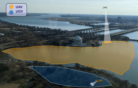
In this paper, we address the coverage problem for both the energy-constrained UAV and the UGV that will also act as a mobile recharging station. In this formulation, we assume that each of the robots has its own assigned region to cover (Fig. 1). We design a complete coverage pipeline that takes the area to be covered as input and produces paths for UAV and UGV that not only provide coverage but also respect UAV’s energy constraint by finding appropriate rendezvous locations. We propose the Air-Ground Coverage Path Planning Algorithm (AG-Cvg), which first builds coverage paths without taking energy constraints into account. Following this, it segments these paths and utilizes graph matching techniques to allocate UAV path clusters to UGV path clusters, reducing distances traveled for rendezvous on average by , with up to 25 improvement on some instances.
The contributions of this paper are:
-
•
The first coverage path planning algorithm when both UAV and UGV simultaneously perform coverage and the UGV acts as a mobile recharging station.
-
•
Feasibility guarantee for recharging of the energy-constrained UAV.
-
•
Real-world deployment system for executing generated trajectories in the field with a VOXL m500 drone and Clearpath Jackal ground vehicle.
The rest of this paper is organized as follows. We begin with an overview of the recent works in the field in Section II. We formally define the problem in Section III and follow with a description of the proposed AG-Cvg algorithm. Experiments both on numerical results and real-world deployments are discussed in Section V. Finally, Section VI summarizes the results and lessons learned.
II RELATED WORK
Offline area coverage planning is particularly useful for large-scale environments. While learning-based methods can be helpful in incorporating uncertainties about the environment, these approaches are limited to small-scale decision spaces [12]. Therefore, offline plans can be helpful in breaking down the complexity of large-scale operations, which is especially commonly faced by scientists who perform systematic data collection over extended periods of time.
The area coverage path planning problem has been extensively studied in robotics [9, 13]. Depending on the goal or constraints of the coverage operation, different variations have been presented such as coverage under limited resources [14], complete coverage, information-driven coverage [15] or sampling-based coverage [16].
The boustrophedon area decomposition approach is a commonly employed technique for achieving complete coverage. It involves dividing the area of interest into cells that are free of obstacles and subsequently directing the robot to traverse each cell in a lawnmower-like pattern to ensure complete coverage [17]. Many studies have utilized this method as a primary means of addressing coverage problems [18], while others have utilized it as a supplementary technique for improving the quality of coverage [19].
A polynomial-time algorithm was proposed by Xu et al. [20] for solving single robot coverage that uses a Boustrophedon Cell decomposition (BCD). Here, the problem is represented as a Chinese postman problem (CPP), which ensures an efficient coverage order of cells. The multi-robot extension for vehicles with and without dubin’s constraint was proposed as well [21, 22].
In this paper, we address the energy constraints of the UAV by utilizing the UGV as a mobile recharging station. This cooperative path-planning strategy involving multiple mobile and static recharging stations has been explored in the literature [23].
For instance, this problem has been studied in 1D [24, 25] for persistent visual monitoring of linear features with multi-agent systems that need to be recharged while performing the monitoring mission. The problem has been defined as a Mixed-Integer programming problem and solved through the branch-and-cut approach. In 2D space, Yu et al. [7] discuss the challenges of completing a tour while using a UGV as a station to periodically recharge the UAV. Authors in [11, 26] examine the risk-aware version of this problem with stochastic energy consumption. The work presented in [8] is closely related to our approach, as it also considers mobile recharging for a UAV performing coverage in an environment with limited battery capacity. However, in our study, the UGV has the additional task of covering the environment while providing mobile recharging services to the UAV.
As such to the best of our knowledge the presented work is the first attempt to present a complete system for solving a coverage path planning problem with both a mobile recharging vehicle and an energy-constrained vehicle.
III Problem Formulation
Consider an environment and regions of the environment representing the areas to be covered by a single UGV and a single UAV respectively. (Note: in the notations, we will use subscript to denote UAV variables and for UGV variables.) The regions and that may or may not overlap. The UAV has an energy constraint and its maximal endurance in the air while performing coverage is denoted as , including the takeoff time and landing time . The UGV is equipped with a recharging station and the UAV can land on the UGV to be recharged. We assume that both UAV and UGV maintain constant speeds and respectively. With this assumption, the maximum distance UAV can travel before discharging is .
Given the sensor footprints and of the UAV and UGV respectively, the objective is to find paths for each that will provide complete coverage of the regions in a minimal amount of time, while satisfying the UAV’s energy constraints. The UAV and UGV must rendezvous for recharging if the size of the mission is larger than the single UAV battery life.
The problem is formally defined as follows.
Problem 1
Given environment with regions , sensor footprints , , and UAV energy constraint , find paths and in for the UAV and UGV respectively, such that
-
•
The paths and avoid obstacles.
-
•
Each point in the region () is covered by the sensor footprint () along the path ().
-
•
The UAV must be able to traverse without running out of charge, i.e., in every segment of of length at least , there must be at least one rendezvous with the UGV.
-
•
The total path length is minimized.
Note that the rendezvous not only means that the paths and must intersect, but also that the UGV and UAV must be at the intersection point at the same time.
This problem is NP-hard since the area coverage problem even without consideration of energy constraint is proven to be NP-hard [27]. In the next section, we describe our proposed heuristic approach to solve this problem.
Input: binary map of environment ,
and subregions
battery capacity
sensor footprint parameters and
Output: and paths
IV Proposed Approach
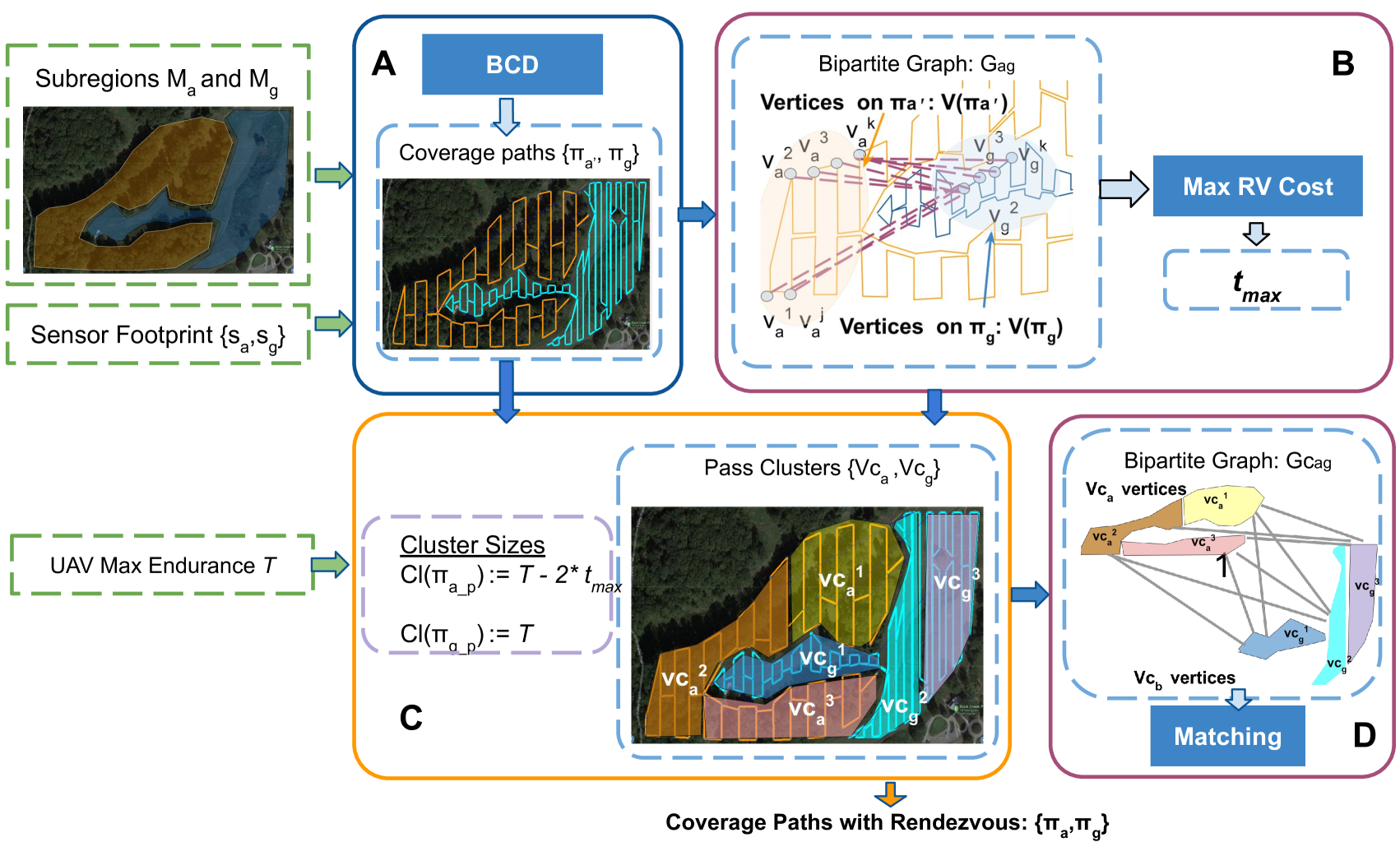
In this section, we propose a heuristic method to solve Problem 1. The method AG-Cvg, outlined in Algorithm 1 and visually depicted in Fig. 2, is based on boustrophedon decomposition coverage planning [20] and graph matching [28]. The main intuition behind this approach is that the UAV has to recharge after each units of time. As such we want to ensure that the coverage trajectory contains a rendezvous after every units of time. In practice, UGVs are restricted in the locations they can traverse whereas UAVs can usually fly directly between any pair of points. Hence in this work, we propose that only one of the robots (UAV) needs to take the rendezvous detour, and the other (UGV) will simply perform its own coverage task and rendezvous on its own coverage path.
The AG-Cvg algorithm comprises four main steps (see Algorithm 1). The first step (lines 1-2) (Fig. 2A) generates complete coverage trajectories using an efficient single robot coverage algorithm based on BCD [20] for both the UGV and UAV. This produces an ordered list of waypoints for each vehicle.
The second step (lines 3–5) (Fig. 2B) involves estimating the maximum rendezvous cost by building a bipartite graph with vertices and edges connected between them. Note that the edge cost — distance between UAV and UGV waypoints — is calculated in the -plane, since UAV altitude is constant during the coverage. The algorithm then finds the maximum matching cost solving a maximum flow algorithm [28].
The third step (line 6–7) (Fig. 2C), clusters the coverage trajectories such that a segment of the path in each cluster can be traversed by the UAV within the available battery capacity , taking into account worst-case rendezvous time, i.e., the length of each segment is . For the UGV, since it does not need to leave its path for a rendezvous, the length of the path segment within a cluster is . The resulting clusters for the UAV and the UGV are denoted as and respectively.
Finally step four (lines 8–16) (Fig. 2D), involves finding the rendezvous locations by building another bipartite graph between the clustered paths of the UGV and UAV and finding the perfect matching between them. The edge costs between the vertices of and are the time taken by the UAV to travel from the end/beginning of the cluster in to the end/beginning of the cluster in . This matching ensures that all the segments of the coverage path are traversed and none of them is repeated. If the path segment is matched with the segment , the UAV goes for a recharging rendezvous to the endpoint of after traversing the path segment . The UAV traverses one of the segments, say , and then goes for rendezvous to the endpoint of the UGV’s segment (lines 11–16). In addition, depending on the size of UAV and UGV trajectory clusters and , the UAV path will be defined in the following way:
IV-1 If
the UAV path will consist of all the vertices contained in the original coverage path where the order corresponds to UGV’s path order in . After completing a rendezvous, the UGV moves to its next segment, say , and the UAV moves to the segment that is matched with .
IV-2 If
the UGV will act as a static recharging location at the end of . The UAV will rendezvous normally for the segments that have a bipartite matching with UGV segments, whereas, for the rest of the segments it will rendezvous with the UGV at the end of the UGV’s path.
IV-3 If
,the UAV trajectory will have idle periods when it is carried from UGV’s one location to the other until UGV reaches a cluster that has a matching UAV cluster. For the rest of the matched UAV clusters, the path is created the same way as in the first step.
V Experiments
We performed extensive testing on maps of different sizes and different regions as assigned areas for coverage. Our experimental setup is designed to show the execution of the complete system - from generating paths on satellite images to real-world waypoint execution.
V-A Simulation Results
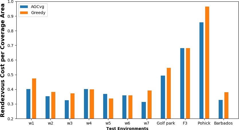
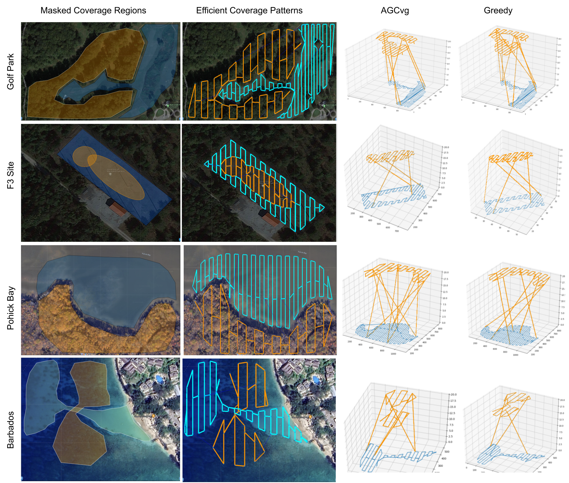
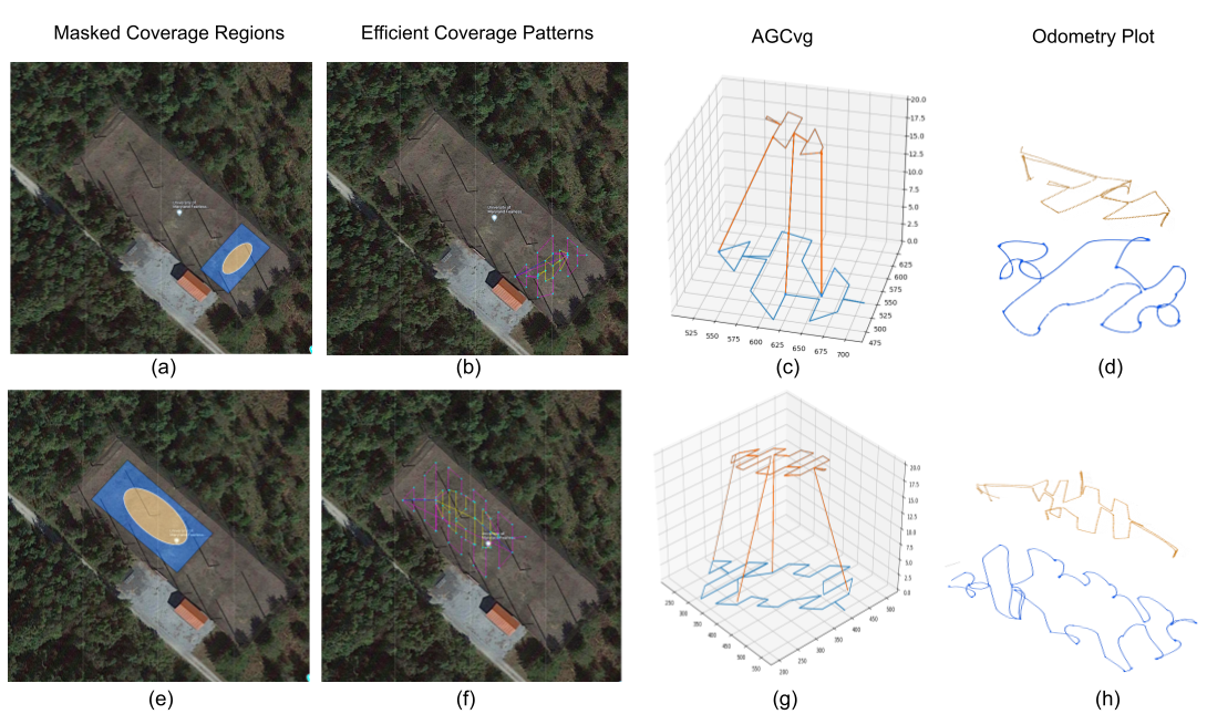
We compare our method AG-Cvg with a greedy approach, where instead of solving the matching problem (Algorithm 1 line 9), to find rendezvous UAV chooses to rendezvous at the closest UGV cluster/path segment. The experimental setup consists of 11 different coverage scenarios with different layouts and scales. Four scenarios are depicted in Fig. 4 to illustrate the resulting missions. The input consists of the satellite images of task areas with predefined masks indicating the regions assigned to UAV and to UGV. It should be noted that the proposed method is an offline approach and does not make any assumptions about the type of vehicle. Therefore, this method can be applied to any cooperative coverage task where the robots are capable of performing waypoint navigation.
Since the base algorithm for coverage is an efficient complete coverage method [20], we compare the rendezvous overhead as a fraction of the original coverage trajectory that the UAV would have taken (Figure 3), e.g. , where denotes the actual length of the coverage trajectory and denotes the length of the coverage trajectory without the energy constraint. The results show that our method – AG-Cvg outperforms on average by at least 11.33% greedy method and in some scenarios even reaches 25% improvement.
V-B Field Deployment
V-B1 UGV Platform
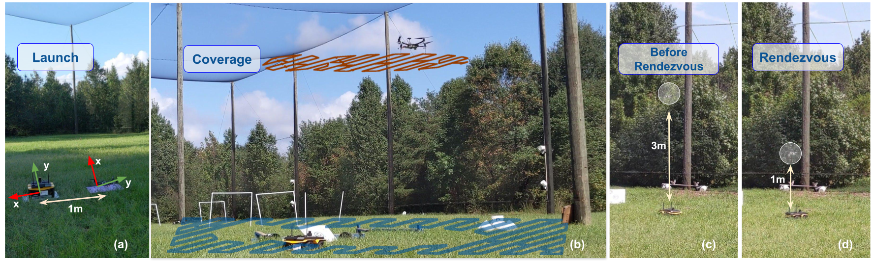
We use Clearpath Jackal UGV equipped with Hokuyo UST-10LX Lidar and IMU for localization. The onboard computer is Jetson AGX Xavier running Ubuntu 20.04 with ROS Noetic. The maximum speed of the vehicle is 2m/s but we set it to 1m/s in all experiments. The generated waypoints are relative to UGV’s start position and the coordinate frame follows the right-hand rule: aligned with the front of the robot, - left side (see Fig. 5a)
V-B2 UAV Platform
We used VOXL m500 UAV equipped with PX4 controller, ModelAI OV7251 Stereo camera for localization, and range-sensor for altitude estimation. The onboard computer is the VOXL flight board installed with Linux-based voxl operating system. The total operational time in the air is 20 minutes. The maximum speed of the platform has been set to 1 m/s. The PX4 SDK was used to interface with the UAV and ROS. The generated waypoints are relative to UGV’s frame with (0,1) starting point. The UAVs coordinate frame is according to the left-hand rule: aligned with the front of the drone, -right side, and aligned with altitude (Fig. 5a).
V-B3 Execution
The experiments were conducted at the Fearless Flight Facility (F3) at the University of Maryland, College Park (Fig. 5 - 6). F3 is a secure facility for outdoor drone tests with 100-foot wide, 300-foot long, and 50-foot high dimensions. We performed two flights with different sensor footprints and battery capacity values on a small region with a size of x and a larger region with x size (see Fig. 6). In the smaller region, we set the battery capacity 2x smaller than in the larger environment to generate at least three rendezvous points, while in the larger region, we have 4 rendezvous locations.
We use Ground Station (GS) equipped with Intel Core i9, running Ubuntu 18.04 and ROS Melodic. Both UAV and UGV use the GS as the ROS Master. The AG-Cvg algorithm is implemented as a C++ library, that also provides flight-ready mission plans with respect to the selected launch position (Fig. 5 (a)).The resulting mission files are passed as an input to the ROS-based packages that handle the rendezvous mission. While the mission point is not a rendezvous location both vehicles perform the coverage with UAV flying on a constant altitude of 3m (Fig. 5 (b)). Once the rendezvous location has been reached each of the vehicles is waiting until for the other vehicle to arrive (Fig. 5 (c)). When rendezvousing, the UAV descends to 1m altitude and hovers (Fig. 5 (d)) (we do not address precision landing in this paper).
VI CONCLUSIONS
In conclusion, this paper presents a comprehensive approach to solving the problem of coverage path planning for energy-constrained UAV and UGV teams. Our approach is motivated by the need to minimize rendezvous time while ensuring successful coverage. We proposed a heuristic method to solve this problem by clustering segments of the coverage paths before using graph matching to find rendezvous for recharging. We conducted numerical analysis on real-world monitoring applications showing that our approach outperforms the Greedy approach, reducing rendezvous overhead by an average of 11.33%, with up to 25% improvement in some cases. We also successfully deployed our approach on a team consisting of a VOXL m500 drone and Clearpath Jackal ground vehicle - showing the full system execution from the satellite map to the real world. Our results demonstrate the feasibility and effectiveness of our approach in addressing the coverage path planning problem for energy-constrained UAV and mobile recharging UGV teams.
Limitations and Future Work: The presented approach AGCvg is an offline coverage and rendezvous method that assumes that the energy consumption is deterministic. This method gives us a strategy on how to perform coverage when the energy is drawn at a constant rate, though when operating in the real world this usually will not be the case. To handle stochastic energy consumption, applying risk-aware online decision-making methods such as those proposed by Shi et al. [11] to different clusters is an interesting direction for future work.
References
- [1] L. C. Santos, F. N. Santos, E. S. Pires, A. Valente, P. Costa, and S. Magalhães, “Path planning for ground robots in agriculture: A short review,” in 2020 IEEE International Conference on Autonomous Robot Systems and Competitions (ICARSC). IEEE, 2020, pp. 61–66.
- [2] Y. Zhou, P. Li, Z. Ye, L. Yue, L. Gui, X. Jiang, X. Li, and Y.-h. Liu, “Building information modeling-based 3d reconstruction and coverage planning enabled automatic painting of interior walls using a novel painting robot in construction,” Journal of Field Robotics, vol. 39, no. 8, pp. 1178–1204, 2022.
- [3] M. Dunbabin and L. Marques, “Robots for environmental monitoring: Significant advancements and applications,” IEEE Robotics & Automation Magazine, vol. 19, no. 1, pp. 24–39, 2012.
- [4] N. Karapetyan, J. Moulton, and I. Rekleitis, “Meander-based river coverage by an autonomous surface vehicle,” in Field and Service Robotics: Results of the 12th International Conference. Springer, 2021, pp. 353–364.
- [5] Y. Sung, J. Das, and P. Tokekar, “Decision-theoretic approaches for robotic environmental monitoring–a survey,” arXiv preprint arXiv:2308.02698, 2023.
- [6] P. Tokekar, J. Vander Hook, D. Mulla, and V. Isler, “Sensor planning for a symbiotic uav and ugv system for precision agriculture,” IEEE transactions on robotics, vol. 32, no. 6, pp. 1498–1511, 2016.
- [7] K. Yu, A. K. Budhiraja, S. Buebel, and P. Tokekar, “Algorithms and experiments on routing of unmanned aerial vehicles with mobile recharging stations,” Journal of Field Robotics, vol. 36, no. 3, pp. 602–616, 2019.
- [8] K. Yu, J. M. O’Kane, and P. Tokekar, “Coverage of an environment using energy-constrained unmanned aerial vehicles,” in 2019 international conference on robotics and automation (ICRA). IEEE, 2019, pp. 3259–3265.
- [9] E. Galceran and M. Carreras, “A survey on coverage path planning for robotics,” Robotics and Autonomous systems, vol. 61, no. 12, pp. 1258–1276, 2013.
- [10] N. Karapetyan, “Robot area coverage path planning in aquatic environments,” Ph.D. dissertation, University of South Carolina, 2021.
- [11] G. Shi, N. Karapetyan, A. B. Asghar, J.-P. Reddinger, J. Dotterweich, J. Humann, and P. Tokekar, “Risk-aware uav-ugv rendezvous with chance-constrained markov decision process,” in 2022 IEEE 61st Conference on Decision and Control (CDC). IEEE, 2022, pp. 180–187.
- [12] A. K. Lakshmanan, R. E. Mohan, B. Ramalingam, A. V. Le, P. Veerajagadeshwar, K. Tiwari, and M. Ilyas, “Complete coverage path planning using reinforcement learning for tetromino based cleaning and maintenance robot,” Automation in Construction, vol. 112, p. 103078, 2020.
- [13] H. Choset, “Coverage for robotics–a survey of recent results,” Annals of mathematics and artificial intelligence, vol. 31, pp. 113–126, 2001.
- [14] G. P. Strimel and M. M. Veloso, “Coverage planning with finite resources,” in 2014 IEEE/RSJ International Conference on Intelligent Robots and Systems. IEEE, 2014, pp. 2950–2956.
- [15] L. Paull, S. Saeedi, M. Seto, and H. Li, “Sensor-driven online coverage planning for autonomous underwater vehicles,” IEEE/ASME Transactions on Mechatronics, vol. 18, no. 6, pp. 1827–1838, 2012.
- [16] B. Englot and F. Hover, “Sampling-based coverage path planning for inspection of complex structures,” in Proceedings of the International Conference on Automated Planning and Scheduling, vol. 22, 2012, pp. 29–37.
- [17] H. Choset, “Coverage of known spaces: The boustrophedon cellular decomposition,” Autonomous Robots, vol. 9, no. 3, pp. 247–253, 2000.
- [18] R. Bähnemann, N. Lawrance, J. J. Chung, M. Pantic, R. Siegwart, and J. Nieto, “Revisiting boustrophedon coverage path planning as a generalized traveling salesman problem,” in Field and Service Robotics: Results of the 12th International Conference. Springer, 2021, pp. 277–290.
- [19] A. Khan, I. Noreen, H. Ryu, N. L. Doh, and Z. Habib, “Online complete coverage path planning using two-way proximity search,” Intelligent Service Robotics, vol. 10, no. 3, pp. 229–240, 2017.
- [20] A. Xu, C. Viriyasuthee, and I. Rekleitis, “Efficient complete coverage of a known arbitrary environment with applications to aerial operations,” Autonomous Robots, vol. 36, pp. 365–381, 2014.
- [21] N. Karapetyan, K. Benson, C. McKinney, P. Taslakian, and I. Rekleitis, “Efficient multi-robot coverage of a known environment,” in 2017 IEEE/RSJ International Conference on Intelligent Robots and Systems (IROS). IEEE, 2017, pp. 1846–1852.
- [22] N. Karapetyan, J. Moulton, J. S. Lewis, A. Q. Li, J. M. O’Kane, and I. Rekleitis, “Multi-robot dubins coverage with autonomous surface vehicles,” in 2018 IEEE International Conference on Robotics and Automation (ICRA). IEEE, 2018, pp. 2373–2379.
- [23] C. Liu, J. Zhao, and N. Sun, “A review of collaborative air-ground robots research,” Journal of Intelligent & Robotic Systems, vol. 106, no. 3, p. 60, 2022.
- [24] P. Maini, P. Tokekar, and P. Sujit, “Visibility-based persistent monitoring of piecewise linear features on a terrain using multiple aerial and ground robots,” IEEE Transactions on Automation Science and Engineering, vol. 18, no. 4, pp. 1692–1704, 2020.
- [25] P. Maini, K. Yu, P. Sujit, and P. Tokekar, “Persistent monitoring with refueling on a terrain using a team of aerial and ground robots,” in 2018 IEEE/RSJ International Conference on Intelligent Robots and Systems (IROS). IEEE, 2018, pp. 8493–8498.
- [26] A. B. Asghar, G. Shi, N. Karapetyan, J. Humann, J.-P. Reddinger, J. Dotterweich, and P. Tokekar, “Risk-aware resource allocation for multiple uavs-ugvs recharging rendezvous,” 2023.
- [27] E. M. Arkin, S. P. Fekete, and J. S. Mitchell, “Approximation algorithms for lawn mowing and milling,” Computational Geometry, vol. 17, no. 1-2, pp. 25–50, 2000.
- [28] S. S. Skiena, The algorithm design manual. Springer, 2008, vol. 2.