colorlinks, pdfa=true, breaklinks, citecolor=black, urlcolor=black, linkcolor=black
Mirpur Cantonment, Dhaka–1216, Bangladesh
11email: ovitareque@gmail.com 11email: nomaiyabashree2002@gmail.com 11email: protik.eece@gmail.com 11email: shakilmrf8@gmail.com 11email: masumaanjum48@gmail.com
Performance Analysis of Various EfficientNet Based U-Net++ Architecture for Automatic Building Extraction from High Resolution Satellite Images
Abstract
Building extraction is an essential component of study in the science of remote sensing, and applications for building extraction heavily rely on semantic segmentation of high-resolution remote sensing imagery. Semantic information extraction gap constraints in the present deep learning based approaches, however can result in inadequate segmentation outcomes. To address this issue and extract buildings with high accuracy, various efficientNet backbone based U-Net++ has been proposed in this study. The designed network, based on U-Net, can improve the sensitivity of the model by deep supervision, voluminous redesigned skip-connections and hence reducing the influence of irrelevant feature areas in the background. Various effecientNet backbone based encoders have been employed when training the network to enhance the capacity of the model to extract more relevant feature. According on the experimental findings, the suggested model significantly outperforms previous cutting-edge approaches. Among the efficientNet variation Unet++ based on efficientb4 achieved the best result by scoring mean accuracy of %, mean iou of %, and mean precision of % on publicly available Massachusetts building dataset and thus showing the promises of the model for automatic building extraction from high resolution satellite images.
Keywords:
Deep learningsatellite imagetransfer learning segmentation deep supervision1 Introduction
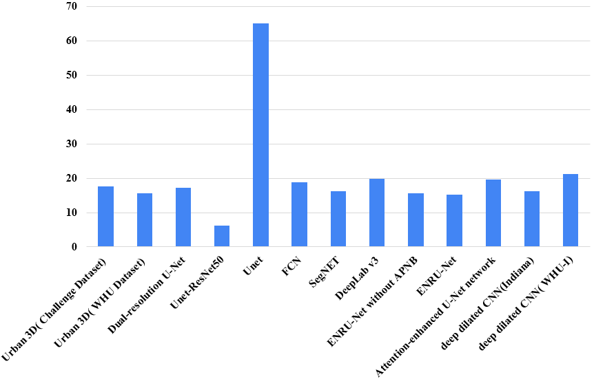
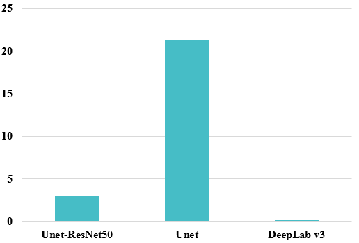
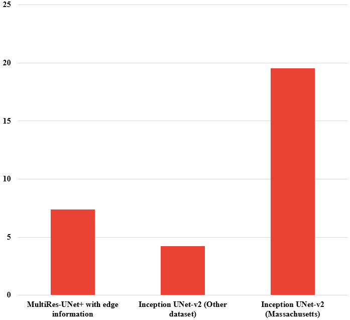
Estimating population density, urban planning, and the creation and updating of topographic maps all rely on the automatic recognition and building extraction from remote-sensing photos. Despite the attention that building extraction has gotten, it is still a difficult operation because of the noise, occlusion, and intricacy of the background in the original remote sensing images. Buildings can be extracted from remote sensing images using a number of different techniques that have been developed recently.Deep convolutional neural networks (CNN) advancements have led to a revolution in the automatic extraction of cartographic information from extremely high resolution aerial and satellite imagery. The fundamental benefit of these supervised CNNs is that they can automatically learn features from training inputs with little to no task-specific information. The accuracy of CNN is comparable to that of human classification accuracy, but it is constant and quick, allowing for quick application over very vast areas and/or over time.These CNNs could facilitate the quick collection of precise spatial data on city buildings and, in turn, the creation of building environment maps, which are crucial for urban planning and monitoring. Two forms of segmentation with CNN can be used for this building extraction task: instance segmentation and semantic segmentation. A class is assigned to each pixel in an image as part of semantic segmentation. When creating segmentation from extremely high resolution images, this kind of segmentation has an adequate degree of precision. A MultiRes-UNet network was suggested by Abolfazl Abdollahiet al. [1] for the extraction of buildings from aerial photographs. Their performance was remarkable, with an F1 score of %, an MCC of %, and an IOU of % using the AIRS dataset. Using the WHU Building Dataset and Urban3d Challenge dataset, LEILEI XUet al. [2] presented the Holistically-Nested Attention U-Net (HA U-Net) for building segmentation. On the Urban3d dataset, they obtained an IOU of % and a Kappa of %; on the WHU Building Dataset, they obtained an IOU of % and a Kappa of %. Waleed Alsabhanet al. [3] used the Massachusetts building dataset to create a U-net architecture for semantic segmentation. Using Unet-ResNet50, they reported an IOU score of % and an accuracy of %, whereas using the traditional U-Net, they recorded an IOU score of % and an accuracy of %. FCN, Segnet, Deeplab V3, and ENRU approaches had been deployed. With these techniques, they attained respective OAs of %, %, %, and %, as well as IoUs of %, %, respectively %, and %. Using WorldView-2 satellite remote sensing picture datasets, Chuangnong Liet al. [4] suggested an attention-enhanced U-Net for building extraction from agriculture. With their model, they attained an accuracy of %, an F1 score of %, a recall of %, and an IOU of %. Ibrahim Delibasogluet al. [5] used the Massachusetts building dataset along with the Ikonos and Quickbird pan-sharpened satellite image collection to design an Inception UNet-v2 architecture for building detection. On the Ikonos dataset, they acquired a precision of % and an F1 score of %. On the Massachusetts building dataset, they attained a precision of % and an F1 score of %. Mehdi Khoshboresh-Masoulehet al. [6] suggested a deep dilated CNN for developing extraction from the Indiana, WHU-I, Inriaa, and Potsdama datasets. They performed well, earning F1 scores between % and % and IOU scores between % and %. DeepResUnet was presented by Yaning Yiet al. [7] for the segmentation of urban buildings from aerial pictures. Using their model, they were able to attain accuracy of %, recall of %, an F1 score of %, and a Kappa of %. By using WorldView-3 images for generating instance segmentation, Fabien H. Wagneret al. [8] obtained an overall accuracy of % using the U-net architecture.
According to current literature, there have been various attempts to semantically segment buildings from satellite images using standard end-to-end deep learning models. However, a complete experiment based on several efficientNet backbones based U-Net++ has not yet been conducted. The usage of labelled data has once again shown that deep learning-based systems have significantly improved. They don’t perform well enough with unlabeled data to qualify as state-of-the-art. Therefore our contribution in the paper can be reported in the way specified below after taking everything into account:
-
a
Proposing an end-to-end deep learning based solution for automatic extraction of buildings from high resolution satellite images with high accuracy using U-Net++ architecture.
-
b
Evaluating a comparative performance analysis among various efficientNet backbones as the encoder for U-Net++ architecture to maximize the performance.
2 Dataset
2.1 Dataset Description
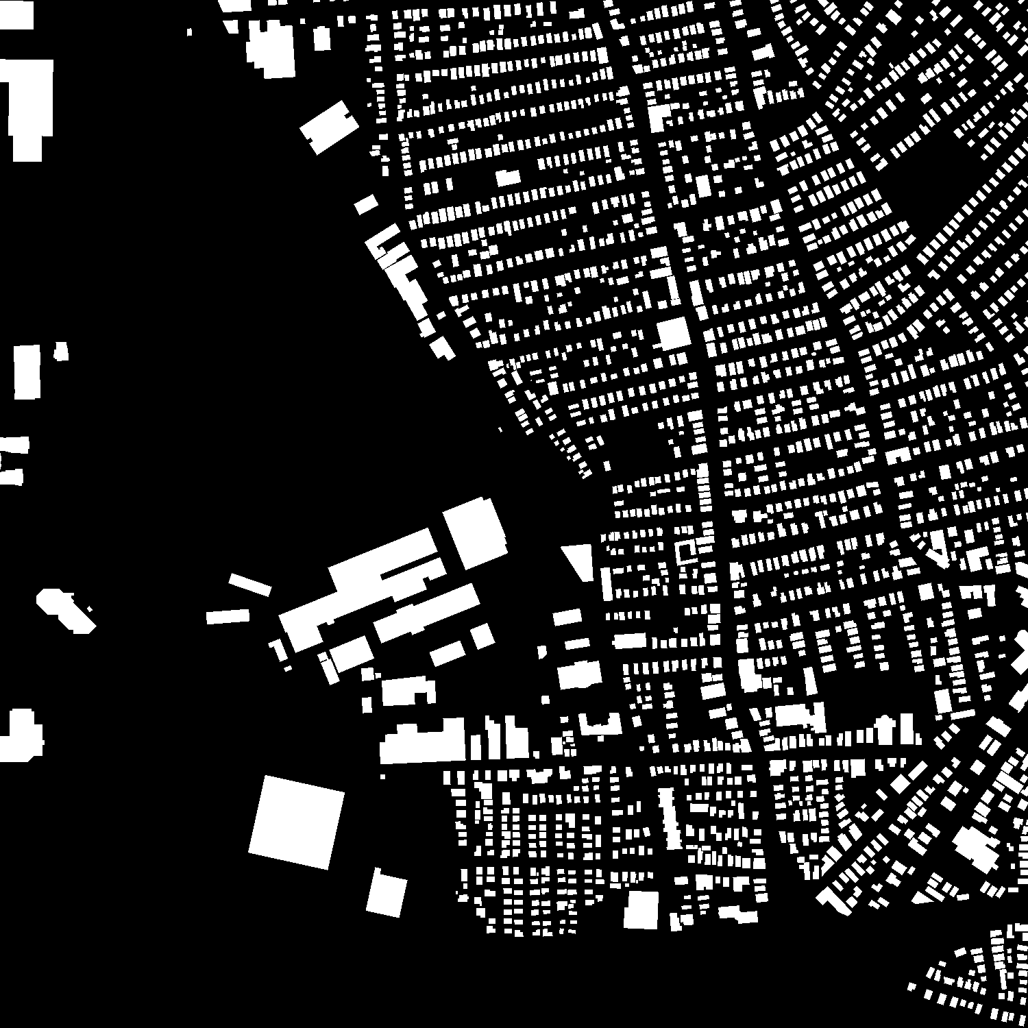
The Massachusetts Buildings Dataset [9] is used in this study which includes aerial images, each having pixels resolution. The dataset is divided into three sets: a training set of images, a test set of images, and a validation set of images.

2.2 Dataset Preprocessing
At first all the images and the ground truths are down-sampled to and the only preprocessing step is to normalize the pixel values from to as the Equation (1). Here represents image height and width respectively, is the original image and is the normalized image. No other prior preprocessing step is required for this study.
| (1) |
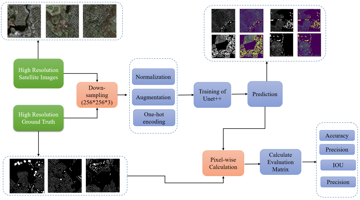
At first both the training images and ground truths are down-sampled to and normalized. After that these images are used for the network training. When the whole training is done the best weight was saved for test purpose and evauluation.
3 Methodology
The following steps illustrate our study and evaluation process.
-
a
At first both the training images and ground truths were down-sampled to from the high resolution satellite images.
-
b
After that these images were normalized and then necessary augmentation and one hot encoding were performed for the training of the proposed network.
-
c
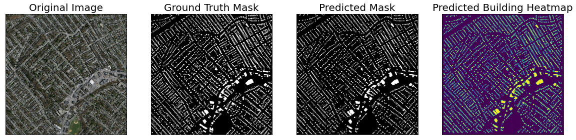
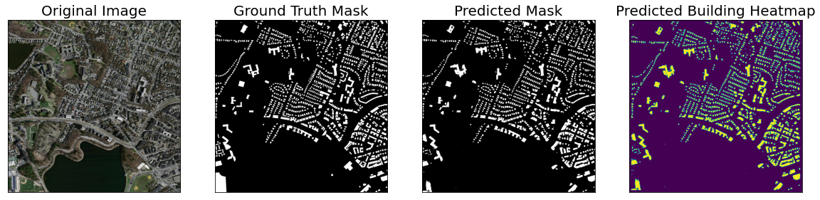
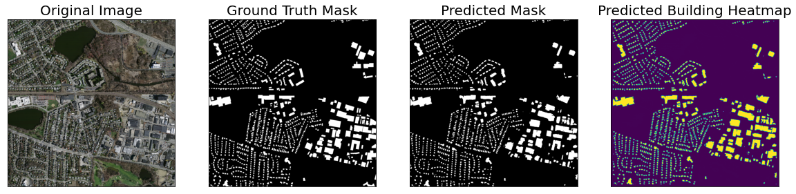
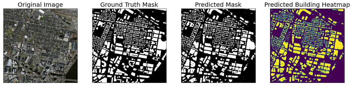
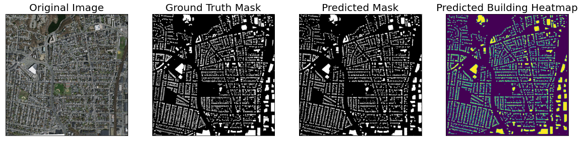
After the training is complete, the best stored weight generates high resolution predictions, which are then evaluated using pixel-by-pixel calculations. In Fig.2, the entire process of this study is depicted.
Below, for better understanding of the proposed methodology, is a brief explanation of U-Net++,EfficientNet backbone architecture.
3.0.1 U-Net++
Using the U-Net as its foundation, UNet++ proposed by Zongwei Zhouet al. [10], is an architecture for semantic segmentation. It improves the extraction of features by utilizing densely linked nested decoder sub-networks. Dense block and convolution layers are being added by UNet++ between the encoder and decoder to further enhance segmentation precision, which is crucial for medical imaging because even small segmentation errors could result in inaccurate results, which would be marginalized in clinical settings. The newly developed skip connections have been introduced by UNet++ in order to bridge the semantic gap between the encoder and decoder subpaths.These convolutional layers are designed to fill the semantic gaps between the encoder and decoder sub-networks’ feature maps. As a result, the optimiser may be faced with a simpler optimization task. Moreover we can summarize the core features of U-Net++ as follows:
-
a
redesign of the skip connections.
-
b
voluminous skip connections.
-
c
extensive supervision.
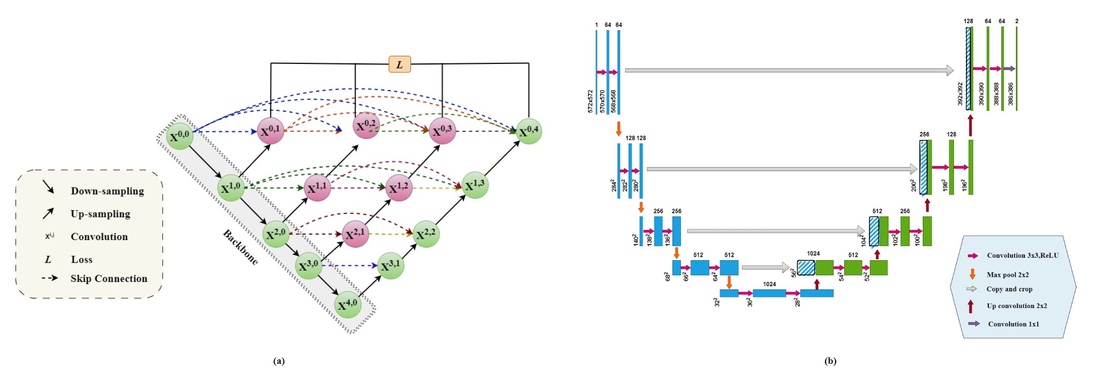
3.0.2 Proposed Architecture
In this study, performance of total efficientNet backbone based Unet++ architecture has been analysed for building density segmentation from high resolution satellite image with high accuracy. Unet++ has been considered for the segmentation architecture instead of Unet because,
-
a
In order to merge the semantic feature gap between contracting and decoder feature maps, convolution layers on skip routes are being used.
-
b
Numerous skip connections based skip pathways are designed to enhance the gradient flow.
-
c
having extensive supervision, which allows for model pruning and improves performance or, in the worst scenario, obtains performance comparable to utilizing just one loss layer.
-
d
By merging otherwise semantically differing feature maps, the U-Net skip connections connect the feature maps directly between the encoder and the decoder.
-
e
UNet++, on the other hand, combines the output of the preceding convolution layer of the same dense block with the matching up-sampled output of the lower dense block. The semantic level of the encoded feature is raised to be closer to that of the feature maps waiting in the decoder when receiving feature maps with equivalent semantic qualities, making optimization easier.
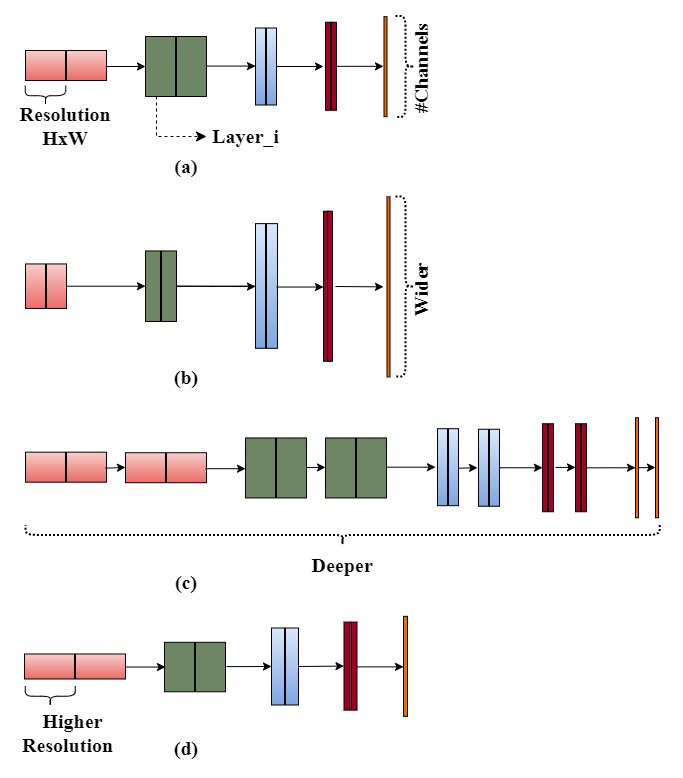
EfficientNet has been chosen for the feature extraction for the following reason,
-
a
For feature extraction, the compound scaling approach significantly increased the model’s accuracy and efficiency compared to earlier CNN models like MobileNet and ResNet..
-
b
the since efficientNet models are designed by neural architecture search, utilizing them as encoders was significantly more computationally effective.
4 Result Analysis
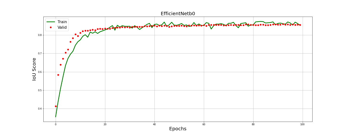
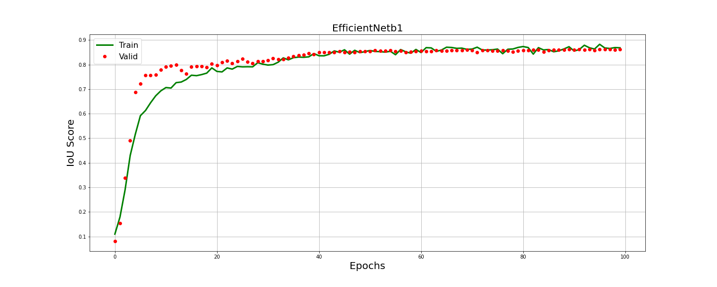
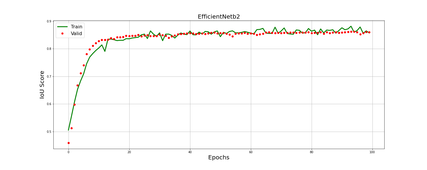
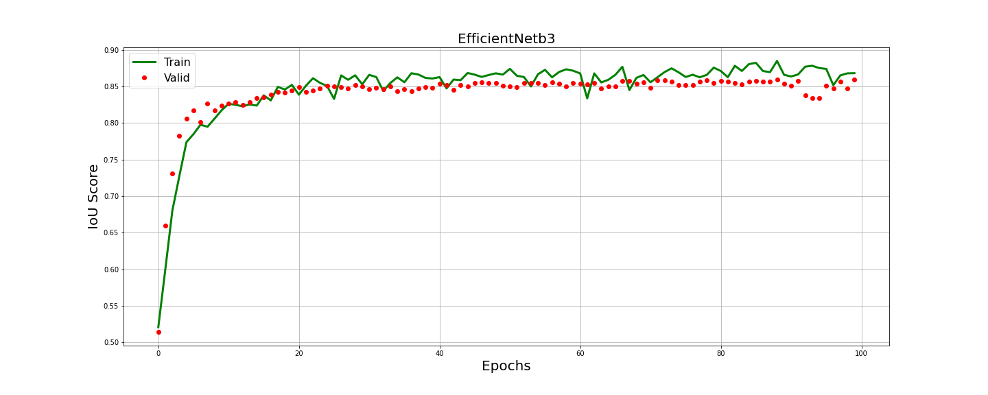
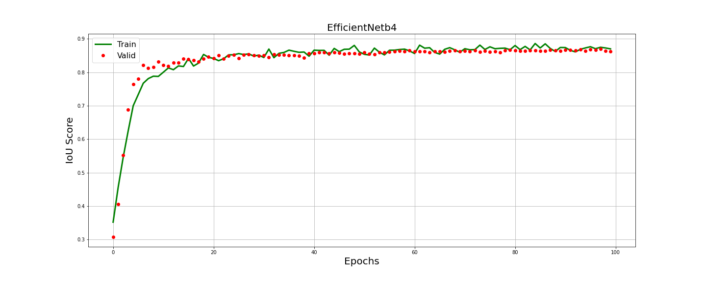
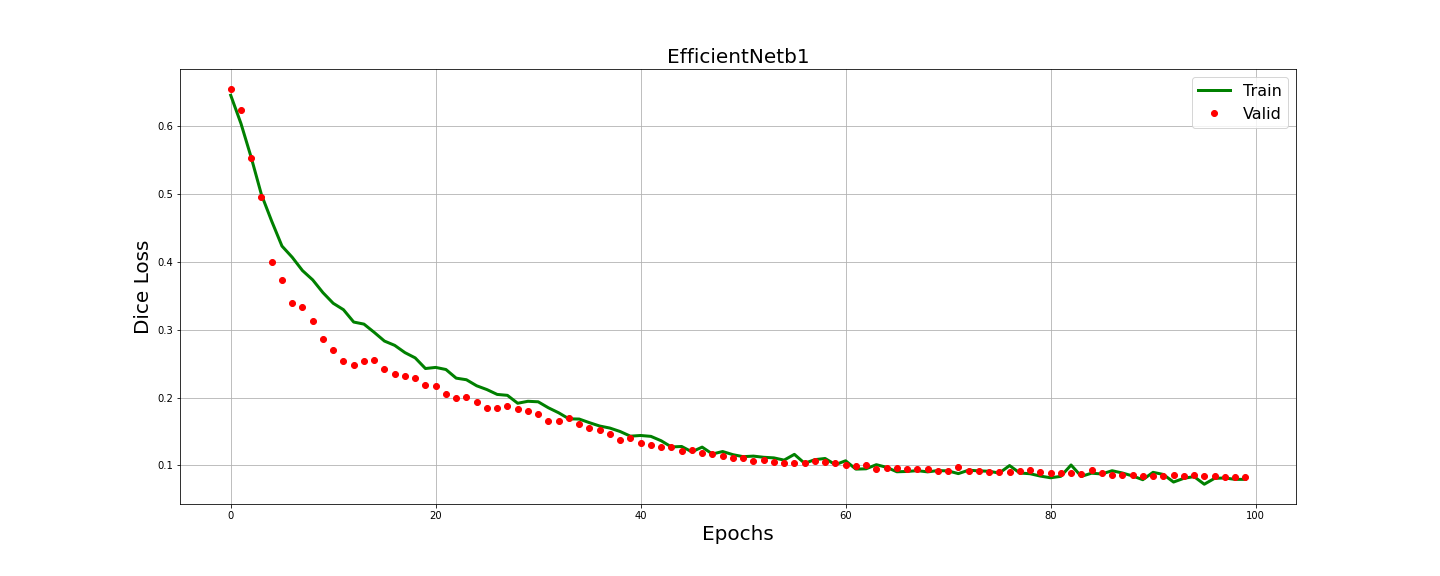
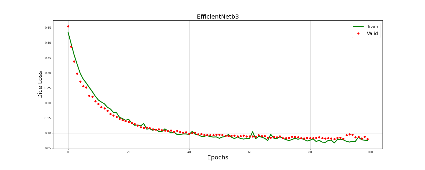
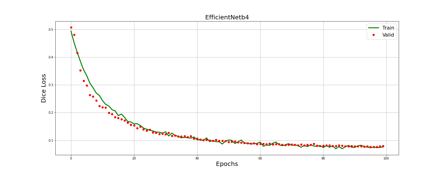
The performance of the models was evaluated based on accuracy, precision, recall, and IoU. Accuracy represents the percentage of correctly classified pixels, precision measures the model’s ability to correctly identify building pixels, recall measures the proportion of actual building pixels correctly identified by the model, and IoU calculates the overlap between the predicted and ground truth masks. Fig.7 and Fig.7 illustrate the training history of IoU score and dice loss for the proposed Unet++ architecture with different EfficientNet-based encoders. The plots show the progress of the evaluation metrics during the training process. Notably, there was no overfitting observed, as the curves for all evaluation parameters demonstrated a steady improvement.
In Fig.5, a improvement is shown among the proposed EfficientNet-based U-Net++ models with other popular architectures. The proposed EfficientNet-based U-Net++ models consistently outperformed most of the compared models in terms of IoU, accuracy, recall and precision. Based on the experimental findings, the EfficientNetb4-based U-Net++ model attained the highest performance among all variants.
However, Table.1 presents a performance comparison between the proposed EfficientNet-based U-Net++ models and some state-of-the-art approaches for building density segmentation. The proposed models achieved remarkable results, outperforming the existing literature across all evaluation parameters by a significant margin. The superior performance of the proposed models demonstrates the effectiveness of incorporating EfficientNet backbones and U-Net++ architecture for building extraction tasks.


| Year | Reference | Dataset | Network(Type) | Matrices |
| 2021 | Abdollahi et al. [1] | AIRS | MultiRes-UNet+ with edge information | MCC-95.73Precision:% F1: 96.98% IoU: - 94.13% |
| 2021 | LEILEI XU et al. [2] | challenge dataset | Urban 3D | Accuracy: % Kappa-80.21% F1-81.24% IoU: 70.66% |
| 2021 | LEILEI XU et al. [2] | WHU dateset | Urban 3D | IoU:72.74% Kappa:79.42% Ins F1:79.32% |
| 2021 | Li et al. [4] | 5 WorldView-2 satellite remote sensing image datasets | attention-enhanced U-Net network | Accuracy-96.96% F1 Score-81.47% Recal-82.72% IoU-68.72% |
| 2020 | Delibasoglu et al. [5] | Ikonos and Quickbird pan-sharpened satellite images dataset | Inception UNet-v2 | Precision-88.97% F1-82.03% Recall-83.78% Kappa-80.28% |
| 2020 | Delibasoglu et al. [5] | Massachusetts building dataset | Inception UNet-v2 | Precision- 73.69% F1-78.39% Recall-75.68% Kappa-71.14% |
| 2020 | Khoshboresh et al. [6] | Indiana | deep dilated CNN | Fi score- 83% IoU-72% |
| 2020 | Khoshboresh et al. [6] | WHU-I | deep dilated CNN | Fi score- 80% IoU-67% |
| 2019 | Yi et al. [7] | Aerial images with a spatial resolution of 0.075m are collected from the public source | DeepResUnet | Precision-94.01% Recall- 93.28% F1- 93.64 % Kappa-91.76% OA-97.09% |
| 2020 | Wagner et al. [8] | WorldView-3 images | U-net-id | accuracy-97.67% Precision-0.936% Recall-0.939% Fi score-0.937% IoU mean-0.582% IoU median- 0.694% Detection rate-97.67% |
| 2018 | Lu et al. [11] | Inria | dual-resolution U-Net | IoU-72.45% |
| 2018 | Lu et al. [11] | Massachusetts buildings | dual-resolution U-Net | IoU-71.03% |
| 2022 | Alsabhan et al. [3] | Massachusetts building dataset | Unet-ResNet50 | dice loss-10.8IoU score-82.2% Accuracy-90.2% F1 score-90.0% |
| 2022 | Alsabhan et al. [3] | Massachusetts building dataset | Unet | dice loss-3.3277% IoU score-23.16% Accuracy-71.9% F1 score-60.3% |
| 2022 | Alsabhan et al. [3] | Massachusetts building dataset | FCN | OA : 93.37% IoU:69.47% F1:81.98% |
| 2022 | Alsabhan et al. [3] | Massachusetts building dataset | SegNET | OA : 93.84% IoU:72.1% F1:93.78% |
| 2022 | Alsabhan et al. [3] | Massachusetts building dataset | DeepLab v3 | OA : 93.01% IoU:68.55% F1:81.34% |
| 2022 | Alsabhan et al. [3] | Massachusetts building dataset | ENRU-Net without APNB | OA : 94.12% IoU:72.77% F1:84.24% |
| 2022 | Alsabhan et al. [3] | Massachusetts building dataset | ENRU-Net | OA : 94.18% IoU:73.02% F1:84.41% |
| 2022 | Ours | Massachusetts building dataset | UNET++ (efficientNetb0) | Mean F1:% Mean IoU:% Mean Precision:% Mean Accuracy :% Mean Recall:% |
| 2022 | Ours | Massachusetts building dataset | UNET++ (efficientNetb1) | Mean F1:% Mean IoU:% Mean Precision:% Mean Accuracy :% Mean Recall:% |
| 2022 | Ours | Massachusetts building dataset | UNET++ (efficientNetb2) | Mean F1:% Mean IoU:% Mean Precision:% Mean Accuracy :% Mean Recall:% |
| 2022 | Ours | Massachusetts building dataset | UNET++ (efficientNetb3) | Mean F1:% Mean IoU:% Mean Precision:% Mean Accuracy :% Mean Recall:% |
| 2022 | Ours | Massachusetts building dataset | UNET++ (efficientNetb4) | Mean F1:% Mean IoU:% Mean Precision:% Mean Accuracy :% Mean Recall:% |
5 Conclusion
Performance investigation of a total of efficientNet based U-Net++ models for extracting building from remote sensing images has been carried out in this paper. For improved accuracy and efficiency, the proposed design combines use of deep supervision, densely connected redesigned skip connections of U-Net++, and the compound scaling technique algorithm of efficientNet. Experimental results showed that efficientNetb4 based U-Net++ had the best performance among all the variant by achieving mean accuracy, iou and precision of %, % and % respectively. Even though the segmentation result produced by our suggested method was excellent, there are still some issues, such as a poor identification effect of nearby buildings, mistaking shadows for structures, and an inability to recognize buildings that are covered in vegetation. Additionally, there is potential for advancement in terms of the precision of the training dataset and validation dataset by increasing their volume and integrating self-supervised attention mechanism in the further study.
References
- [1] A. Abdollahi and B. Pradhan, “Integrating semantic edges and segmentation information for building extraction from aerial images using unet,” Machine Learning with Applications, vol. 6, p. 100194, 2021.
- [2] L. Xu, Y. Liu, P. Yang, H. Chen, H. Zhang, D. Wang, and X. Zhang, “Ha u-net: Improved model for building extraction from high resolution remote sensing imagery,” IEEE Access, vol. 9, pp. 101 972–101 984, 2021.
- [3] W. Alsabhan and T. Alotaiby, “Automatic building extraction on satellite images using unet and resnet50,” Computational Intelligence and Neuroscience, vol. 2022, 2022.
- [4] C. Li, L. Fu, Q. Zhu, J. Zhu, Z. Fang, Y. Xie, Y. Guo, and Y. Gong, “Attention enhanced u-net for building extraction from farmland based on google and worldview-2 remote sensing images,” Remote Sensing, vol. 13, no. 21, p. 4411, 2021.
- [5] I. Delibasoglu and M. Cetin, “Improved u-nets with inception blocks for building detection,” Journal of Applied Remote Sensing, vol. 14, no. 4, pp. 044 512–044 512, 2020.
- [6] M. Khoshboresh-Masouleh, F. Alidoost, and H. Arefi, “Multiscale building segmentation based on deep learning for remote sensing rgb images from different sensors,” Journal of Applied Remote Sensing, vol. 14, no. 3, pp. 034 503–034 503, 2020.
- [7] Y. Yi, Z. Zhang, W. Zhang, C. Zhang, W. Li, and T. Zhao, “Semantic segmentation of urban buildings from vhr remote sensing imagery using a deep convolutional neural network,” Remote sensing, vol. 11, no. 15, p. 1774, 2019.
- [8] F. H. Wagner, R. Dalagnol, Y. Tarabalka, T. Y. Segantine, R. Thomé, and M. C. Hirye, “U-net-id, an instance segmentation model for building extraction from satellite images—case study in the joanópolis city, brazil,” Remote Sensing, vol. 12, no. 10, p. 1544, 2020.
- [9] V. Mnih, “Machine learning for aerial image labeling,” Ph.D. dissertation, University of Toronto, 2013.
- [10] Z. Zhou, M. M. R. Siddiquee, N. Tajbakhsh, and J. Liang, “Unet++: A nested u-net architecture for medical image segmentation,” 2018.
- [11] K. Lu, Y. Sun, and S.-H. Ong, “Dual-resolution u-net: Building extraction from aerial images,” in 2018 24th International Conference on Pattern Recognition (ICPR). IEEE, 2018, pp. 489–494.