Collaborative Active SLAM: Synchronous and Asynchronous Coordination Among Agents*
Abstract
In autonomous robotics, a critical challenge lies in developing robust solutions for Active Collaborative SLAM, wherein multiple robots collaboratively explore and map an unknown environment while intelligently coordinating their movements and sensor data acquisitions. In this article, we present two approaches for coordinating a system consisting of multiple robots to perform Active Collaborative SLAM (AC-SLAM) for environmental exploration. Our two coordination approaches, synchronous and asynchronous implement a methodology to prioritize robot goal assignments by the central server. We also present a method to efficiently spread the robots for maximum exploration while keeping SLAM uncertainty low. Both coordination approaches were evaluated through simulation and experiments on publicly available datasets, rendering promising results.
I INTRODUCTION
Autonomous robotics has emerged as a transformative force in the exploration of complex and uncharted environments. From planetary exploration missions to disaster relief operations, the deployment of autonomous robots has demonstrated a revolutionary potential across a diverse range of applications. At the heart of this success lies the robots’ ability to autonomously explore an environment while gathering data and constructing detailed maps of the surrounding environment in real-time—a process known as Active Simultaneous Localization and Mapping (A-SLAM).
Many research works have recently focused on Active Collaborative SLAM (AC-SLAM), which capitalizes on the power of multiple robots working in collaboration. The potential advantages are manifold, from accelerated mapping of terrains to resilient operation in challenging and dynamic scenarios. However, the utilization of multiple robots in collaborative SLAM is not without its challenges. Coordination, resource allocation, and sensor fusion become critical facets that demand careful consideration. Furthermore, the seamless integration of individual robot efforts into a coherent, unified map poses a non-trivial computational and algorithmic challenge.
We propose a novel implementation of an AC-SLAM algorithm and extend the work in [1] to a multi-agent system, where multiple robots collaboratively map an environment. To achieve this aim, we propose two communication strategies namely synchronous and asynchronous respectively in a centralized approach with a central server, to establish effective communication and coordination of goals among the agents. In the synchronous case, agents await the completion of tasks by all agents before receiving new exploration targets (goals), while in asynchronous implementation robots immediately request new goals from the server once their target goal has been reached. Additionally, we also propose an efficient method to distribute robots in the environment hence favouring exploration and considering agent priorities using reward- and distance-based metrics to optimize goal selection.
II RELATED WORK
II-A Active SLAM
In A-SLAM implementations, the robot can actively choose its actions, such as selecting views or locations to investigate, to reduce the uncertainty of its location and map representation. By intelligently planning and executing robot operations to minimize uncertainty, the final goal is to increase the efficiency and accuracy of SLAM. Hence, A-SLAM formulates the problem into an optimization task by including active control in the SLAM procedure. This involves not only estimating the robot pose and map but also optimizing the robot trajectory and sensor tasks to improve the overall performance. What distinguishes Active SLAM from conventional SLAM methods is the integration of optimal decision-making with SLAM, so as to reduce the uncertainty, as reported by [2], [3].
Modern SLAM method is usually modeled with a graph-based approach. Graph-based approaches, like pose graph optimization [4], [5], [6] and Bundle Adjustment (B.A) [7], [8] are gaining popularity in SLAM due to their capacity to manage big data and the interaction between robots and the environment. Pose graph optimization treats the environment as a graph, with nodes representing robot positions and edges representing the constraints (measurements) among the nodes which may be odometry or landmark measurements. This pose graph optimization involves the estimation of both the landmark and robot positions simultaneously, improving environment reconstruction accuracy. Distributed pose graph optimization and incremental bundle adjustment are adaptations designed for scalability and real-time performance in collaborative active SLAM. We direct interested readers to [9] for the introduction of SLAM methods Furthermore, factor graphs [5], [10], [11] are used to represent a wide variety of problems across robotics, are used for their ability to handle nonlinear relationships and incorporate prior knowledge.
Graph-based approaches define the environment as ([12]), each vertex represents a robot’s pose, and each edge denotes a constraint between two poses. The pose-graph edges are weighted by the covariance matrix , representing uncertainty or covariance of estimated poses and landmarks [13] [2]. In the context of A-SLAM, Theory of Optimal Experimental Design (TOED) [14] is used to provide a scalar mapping of debating on its determinant and Eigenvalues (D-Optimally criterion) to guide the reward function to the goal location (frontier). Interested readers are guided to [15],[11], [16], [17] for discussion of uncertainty quantification methods
II-B Frontiers
A key component of A-SLAM is frontier based exploration initially coined by [18], where the frontier is the boundary separating known map locations from unknown ones, as observed by the robot’s sensors. Frontiers play a pivotal role in augmenting the precision of robot localization within the context of Active SLAM by enabling intelligent exploration and data acquisition strategies, effectively reducing uncertainty, and enhancing the map-building and localization processes. In A-SLAM, the process of learning new information is achieved through adaptive data acquisition strategies that guide the robot to explore previously unknown regions of its environment, acquire informative sensor measurements, and subsequently update its map and localization estimates. Once a frontier has been identified, the robot can use path planning algorithms to reach it and maximise the exploration while minimizing its SLAM uncertainly which can be quantified using TOED approaches.
II-C Collaborative SLAM
When considering multi-robot systems, two primary aspects come into play. Firstly, teams can be either homogeneous, consisting of robots of the same type, or heterogeneous, [19], with various robot types working together. Secondly, the system’s architecture can be centralized, decentralized, or distributed, [15]. Centralized control offers precise coordination but is susceptible to delays and single points of failure. On the other hand, decentralized systems distribute control for enhanced robustness and scalability while requiring effective coordination. Distributed systems empower individual robots for autonomous decision-making, providing fault tolerance and adaptability while demanding efficient communication protocols. Sometimes, systems can combine centralized and distributed elements [19], sharing computational tasks among agents while central nodes handle decision-making.
When multi-robot systems are applied to the exploration and mapping of an unknown environment, significant challenges arise. A crucial aspect is distinguishing between ”global” and ”local” perspectives, [19]. In traditional single-robot SLAM, the local view is the default, with pose and map estimates based on the robot’s internal reference frame. In multi-robot scenarios, maintaining consistency between perspectives becomes crucial, requiring robots to describe landmarks using the same coordinate system. Collaborative SLAM aims to establish this global reference frame, enabling robots to collectively perceive and learn from each other’s observations.
In Centralised Collaborative SLAM, a central server manages information from all agents, centralizing processing and coordination. However, Centralised approaches can become computationally expensive with a large number of robots, while decentralized approaches allow each robot access to a local view and are suitable for large-scale operations, as demonstrated by [4] and [20]. Decentralized Collaborative SLAM offers scalability and efficient distribution of computational tasks among agents. Some approaches involve redundancy in data, [21] and [22], where mapping data are shared among robots, while others are designated for computations. Decentralized systems address certain bottlenecks, being suitable for large-scale operations and providing each robot with its local view, [4], [18], but still face challenges like bookkeeping, information double-counting, and synchronization issues.
Collaborative SLAM consists of two vital components: Front-end processes and Back-end processes [15]. Front-end processes gather data, produce landmark estimates, and manage loop closures, both intra-robot and inter-robot. Intra-robot loop closures mitigate odometry errors, while inter-robot loop closures stitch together poses and local maps of different robots as described in [23], creating a global map of the environment. The Back-end processes focus on estimating robot and map states using data generated by the front end. It is responsible for high computational tasks involving B.A, pose graph optimization using iterative solvers e.g [24] using graph optimization libraries like g2o [5] to compute the estimated robot pose and map.
III METHODOLOGY
While many research works have been focused on collaborative strategies for SLAM, or single-robot active-SLAM, only a few works have dealt with AC-SLAM. However, these approaches present common limitations: they have high computational costs and they do not explicitly implement strategies to speed up the map discovery. In this work, we propose an AC-SLAM approach that overcomes these limitations.
In the context of single robot A-SLAM the work of [1] uses the Open Karto111http://wiki.ros.org/open_karto in ROS noetic222http://wiki.ros.org/noetic . as SLAM Back-end and proposes a modern D-Optimality criterion which is not computationally expensive for uncertainty quantification. This D-optimality criterion is computed as the maximum number of spanning trees in the weighted graph Laplacian. The reward for Each frontier candidate is weighted by this optimality criterion and is passed to the path planner to guide the robot to perform A-SLAM. For a set of frontiers , each robot computes a matrix of rewards as shown in Equation 1.
| (1) |
In this article, we expand [1] to a multi-robot AC-SLAM and propose an efficient frontier sharing and exploration method for AC-SALM. We propose two exploration approaches namely Synchronous and Asynchronous respectively III-A for goal assignment to robots. Additionally, we also present an efficient spread policy III-C for encouraging exploration.
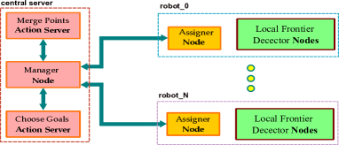
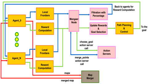
We developed our proposed approach in ROS Noetic using the action severs library333http://wiki.ros.org/actionlib and by adding a central server that receives the list of local frontier points by each robot, computes a global list, and replies with the next target to be reached by the robot. As shown in Figure 1 each robot detects local frontiers in its own map using OpenCV and RRT-based frontier detection from [1] and passes them to the manager node which acts as a communication gateway between the server and robot. The merge Points action server creates a unique list of frontier points to be used by all the agents and choose-goals action server chooses the best goal position for each agent depending on the reward matrix as shown on Equation 1 and spread criterion. Finally, the assigner node receives the chosen goal frontier and executes the path planning action using Dijkstra’s algorithm and DWA planners from the ROS navigation stack444http://wiki.ros.org/navigation as local and global planners respectively. Figure 2 is adopted from our previous work [25] and shows the resultant architecture of the proposed method in ROS with their namespaces. The orange and pink nodes represent the assigner node and central server nodes from Figure 1. The grey node is map merging responsible for taking the maps from each agent and computing a merged map555http://wiki.ros.org/multirobot_map_merge It also provides the required transformation of detected frontier points from the robot’s local to the merged map frame. Filtering with percentage and update rewards & goal selection will be explained in Sections III-C and III-B respectively. In the following Sections, we elaborate on two communication methodologies i.e., synchronous and asynchronous (Section III-A), the management policy of the frontiers (Section III-B) and the spreading policy used to speed up the exploration (Section III-C) are described in detail.
III-A Sychronous and Asynchronous Approach
The communication between the agents and the server has been implemented with two policies: synchronous and asynchronous. In the synchronous approach, during the execution of the program, each agent receives the same number of goals. Moreover, each agent waits for all the other robots in the system to reach their goal before starting a new goal procedure. In this case, the central server (Figure 1) has to manage different agents at the same time and, during the reward computation, the server is given Reward Matrices, (Equation 1) one for each robot. A priority among agents has been set so that goal assignment is performed respecting this sequence: given two agents and with , is assigned a goal before .
In the asynchronous approach, each agent is assigned in sequence as many goals as it can reach, without waiting for other agents. In this case, the priority is used to choose the winning agent in the case multiple agents perform the request at the same time. Since with this policy, an agent with a low priority can be stuck for a long time, there is also a counter that keeps track of this prioritization among the robots and, when an agent with a low priority is not considered for a long time, automatically assigns it the highest priority so as that the server will satisfy its request as soon as possible.
III-B Frontiers Management
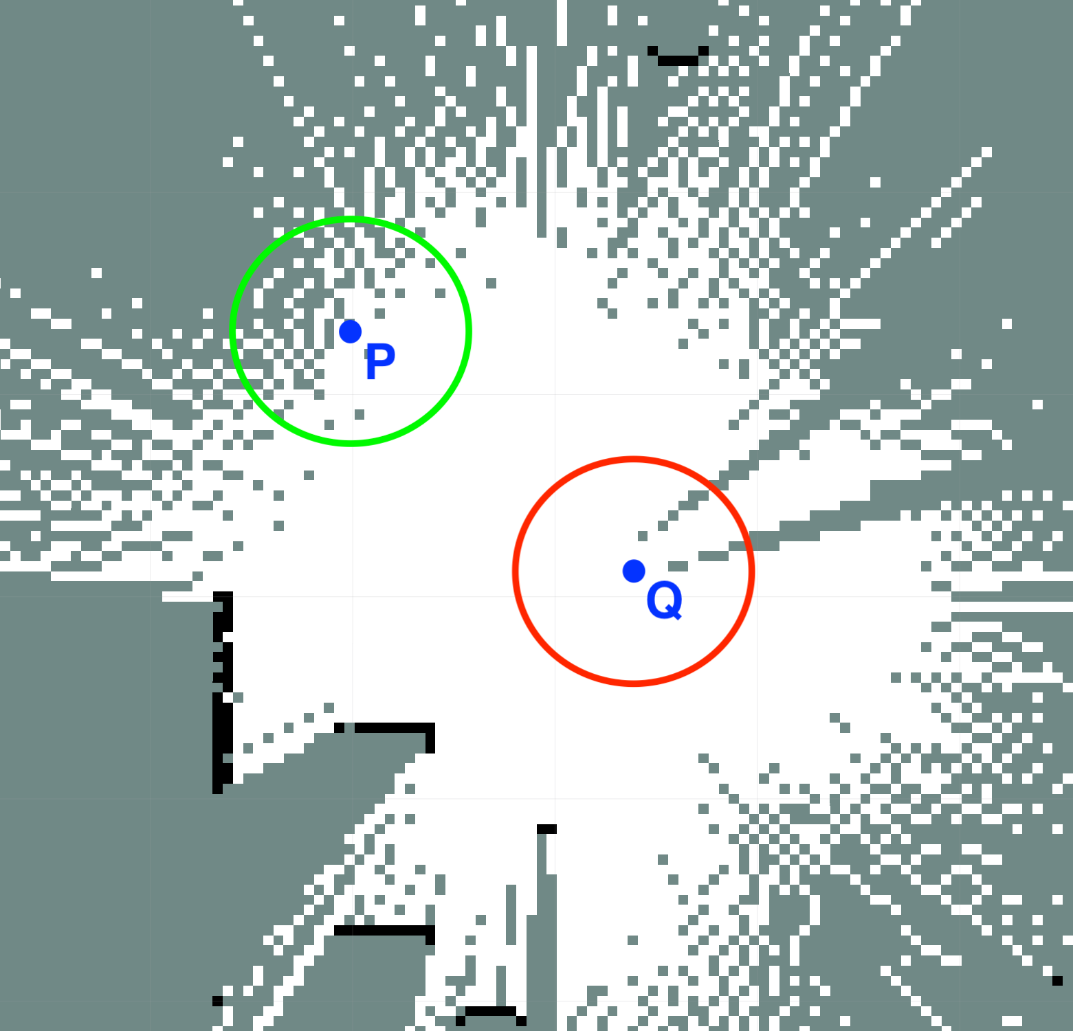
Each agent identifies a certain list of frontier points that will be merged on the server side. Depending on the extent of the map, the final global list may consist of several points, which can lead to high computational time on the server side. For this reason, a strategy to reduce the overall number of frontiers was developed. Also, since we are working on multiple robots, some of the points that are considered frontiers in a local map will be located in a region that is fully mapped when considering the global map. To solve both the aforementioned problems, we decided to consider only those points that have a given percentage of unknown cells within a given radius, using a discretized circle and the global merged map. Figure 3 shows an example list of two points P and Q in a partially discovered global Occupancy Grid (O.G) map. For both points, a circle of known radius RAD is drawn and we compute the percentage of the unknown cells over the total inside the circle. Once the percentage is computed, this point is kept or discarded based on the threshold of PER_UNK set. In the specific case, opportunely setting PER_UNK, point P will be added to the global list, i.e., considered as a border point, whereas point Q will be discarded.
The usage of a discretized circle can lead to an Inclusion error: the discretized circle may include some cells outside the circular boundary. This error leads to false positives. Exclusion error: the discretized circle may exclude some cells within the actual circular boundary. This error leads to false negatives.
The magnitude of the error depends on the resolution used for the O.G map: higher resolutions provide a more accurate approximation of the circle and consequently negligible errors. Unfortunately, using this approach to reduce the list of frontier points (points) may not be sufficient to meet time constraints on the server side. Therefore, we devised an algorithm aimed at further reducing the point number through the adjustment of the radius considered before. The algorithm checks if the global number of points in the list is above a certain threshold: in this case, it recomputes a new list of frontiers by increasing the radius RAD to 0.25m; conversely, if the number of points is below another fixed threshold, the original list is reprocessed by decrementing PER_UNK by 10% the a-priori fixed given percentage of unknown cells on a given radius. This strategy always gives a sufficient number of frontier points in the list.
III-C Spread Policy
To choose targets that allow the agents to explore the map efficiently, a specific spread policy has been implemented. The server keeps track of the already assigned goals both for the asynchronous and the synchronous approach. When a target goal for one agent is selected, the server updates the reward for all other agents from the old reward , by using a subtracting factor as shown in Equation 2.
| (2) |
| (3) |
| (4) |
The numerator , in Equation 3, is set at run time since it depends on the maximum reward for each agent, and the number of targets already assigned. The denominator represents the Euclidean distance computed between the last chosen goal and the frontier points in the matrix. In other words, when the server assigns a target to robot , it will reprocess all the reward matrices for the other agents, updating the reward with a subtractive factor , which strictly depends on the position of the target assigned to robot ( is the distance between this target position and the frontier points in the matrix).
Since the is inversely dependent on the distance, the more the points are closer to already chosen goals the less likely they are to be chosen as the next goals, thus achieving the task of spreading the goals in the environment. Normalizing in Equation 4 with the size of the rewards in each matrix, allows for having a subtractive factor that is scaled with respect to the reward matrix of each agent. Thus taking into account the number of already selected points, possibly distributing the reward ”budget” among them. By dividing the maximum reward by the total number of selected points, when the number of targets already explored becomes significant each point will only receive a smaller portion of the total reward, resulting in a more limited effect of the subtractive parameter.
IV RESULTS
IV-A Simulation Results
The simulations111YouTube link: https://youtu.be/MsZqoaEA0gY were carried out on ROS Noetic, Gazebo, and Ubunto 20.04 on Intel Core i7®, with a system RAM of 32GB and NVIDIA RTX 1000 GPU. As described earlier We modified the approach of [1] and implemented the proposed approach as mentioned in Section III using Open Karto as SLAM backend, RosBot222https://husarion.com/. equipped with Lidar, and planners from the ROS navigation stack. The map used is modified Willow Garage (W.G) 333https://github.com/arpg/Gazebo/. measuring 2072 as shown in Figure 4a, having no dynamic obstacles, The ground truth O.G maps were generated using the gazebo_2Dmap_plugin 444https://github.com/marinaKollmitz/gazebo. which uses wavefront exploration as shown in Figure 4b.
The two AC-SLAM approaches, i.e., synchronous and asynchronous, have been evaluated and compared with the single-agent A-SLAM by using two main metrics namely map coverage percentage to quantify the exploration, and map quality matrices measuring Structural Similarity Index Measurement (SSIM), Root Mean Square Error (RMSE), Alignment Error (AE).
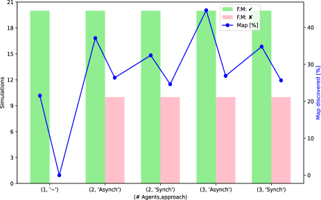
We performed 140 simulations, each one lasting 15 minutes rendering a total simulation time of 35 hours. Figure 5 shows the simulation configurations with 1,2 and 3 robots using synchronous (synch) and asynchronous (asynch) methods respectively.
| # Agents | Approach | F.M. | SSIM (%) | RMSE | AE (%) |
|---|---|---|---|---|---|
| 1 | ✓ | 70.75 | 11.14 | 6.55 | |
| 2 | Synch | ✓ | 71.36 | 9.85 | 5.11 |
| Synch | 72.49 | 9.52 | 3.91 | ||
| 3 | Asynch | ✓ | 71.27 | 9.98 | 5.25 |
| Asynch | 72.15 | 9.81 | 2.21 | ||
| 3 | Synch | ✓ | 70.45 | 9.66 | 4.92 |
| Synch | 71.63 | 8.56 | 3.86 | ||
| 3 | Asynch | ✓ | 70.33 | 10.45 | 5.76 |
| Asynch | 71.52 | 8.23 | 3.56 |
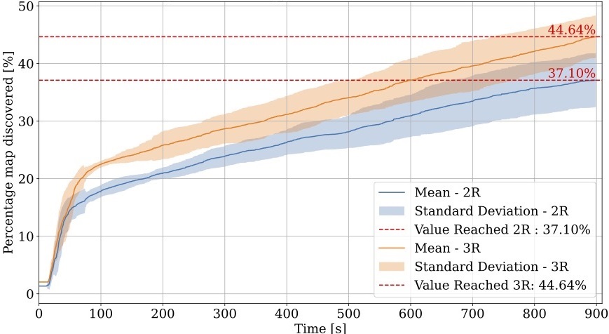
In Figure 5 it is shown the AC-SLAM approach efficiently allows for improving map exploration. In all cases, the percentage of the map discovered (average values are shown) was higher than A-SLAM using the single agent. Also, increasing the number of robots leads to a higher percentage of the map discovered. The asynchronous approach successfully broadens the environment coverage. In all 4 different scenarios, i.e. 2 agents or 3 agents, and with or without frontiers management, the agents controlled synchronously were able to discover a higher percentage of the map concerning the ones controlled synchronously. However, it is worth saying that when the F.M strategy is not adopted, the difference between the two approaches is almost negligible. When the global frontier list is optimized as described in Section III-B, differences are much larger. The importance of adopting a strategy to manage the number of frontier points is even more evident when comparing the results obtained with the same number of agents and the same approach, i.e., asynchronous or asynchronous. Eventually, the frontiers management approach allows for a drastic reduction of the number of possible target points processed by the server. When a proper strategy to opportunely control the number of frontier points is not adopted, increasing the number of robots exploring the environment and adopting collaborative policies does not lead to a significant improvement in the percentage of map discovered (i.e., without the frontiers management, the results obtained with 1, 2, or 3 robots are quite similar). Figure 6 elaborates Figure 5 showing the evolution of % of map discovered using the asynchronous approach with Frontier F.M method, we can observe that clearly increasing the number of robots from 2 to 3 accounts for 20% increase in the averaged mapped area.
Regarding the visual analysis of the maps and debating on map quality matrices, the results on average appear promising as shown in (Table I). Increasing the number of robots in the system and merging their maps did not compromise map resolution or introduce additional errors compared to single robot scenarios. In almost all cases, there was a decrease in RMSE and AE, indicating that increasing the number of robots and merging their maps did not adversely affect performance.
In Figure 7 we can observe that in both the synchronous and asynchronous approach the number of points is reduced significantly, with a reduction of 89%, 97%, 80%, and 82% for all the cases respectively. Consequently reducing the computational cost. The high computational cost required by the reward processing on the server side makes necessary the adoption of F.M strategies to limit the number of global frontiers to be considered.
IV-B Experimental Results
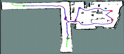
Experiments in a real environment were performed using two ROSBot 2R robots555https://husarion.com/manuals/rosbot/. with RPLidar A2 (Figure 8a) with ROS on Ubuntu 20.04.6 (LTS). The robots are equipped with an Intel Xeon® W-2235 CPU 3.80GHz x 12, with 64Gb RAM and Nvidia Quadro RTX 4000 GPU. The environment consists of a room and two corridors measuring 81 in total as shown in Figure 8b. Figure 11 shows the resultant O.G map along with SLAM pose graphs, using the asynchronous approach with F.M on a team composed of two robots ROSBot 2R robots. We performed four experiments using F.M for both synchronous and asynchronous methods with an experimental time of 20 minutes for each.
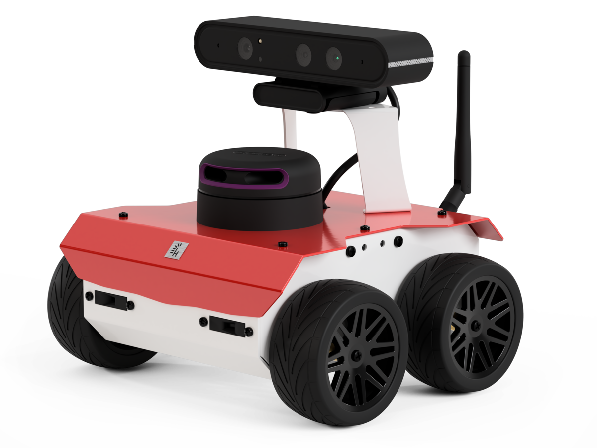
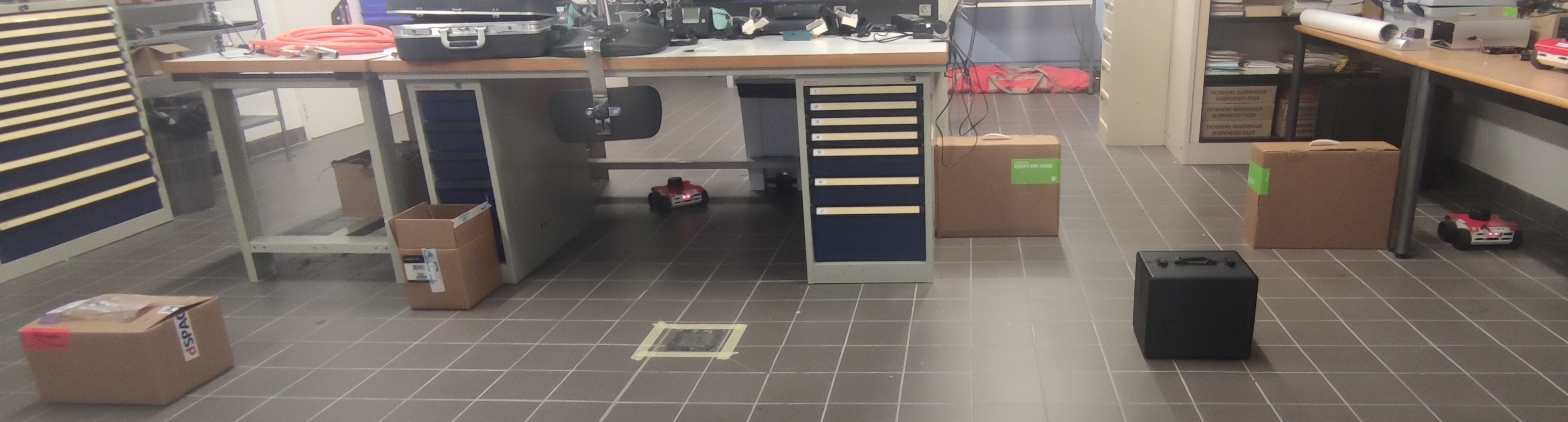
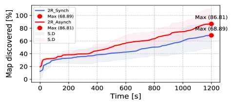
Figure 9 shows the average percentage map of the global map discovered by the robots with synchronous (2 experiments) and asynchronous (2 experiments) methods respectively. It is evident that using the asynchronous approach we manage to cover 26% more map area. Implementing asynchronous coordination also introduced program robustness compared to the synchronous approach. In synchronous mode, the server waits for all agents to publish their lists before the code can proceed. If a robot fails to publish, such as due to node crashes from overload or desynchronization, the system cannot continue. In contrast, in the asynchronous case, if one robot fails, the system can allow the remaining n-1 agents to continue because the crashed robot, not requesting server use, is disregarded.
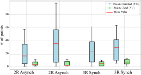
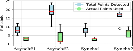
The box plot graph shown in Figure 10 shows a reduction in number of processed points used for exploration using the asynchronous (asynch#1, asynch#2) and synchronous (synch#1, synch#2) methods. We can observe that the average number of points reduces significantly for both methods accounting for 62%, 94%, 28%, and 58% reduction respectively. We also observe that the number of points detected in the synchronous approach is less because the robots wait for each other to reach the goal before processing new points. Thus we observe more points in the asynchronous approach. We observe very less points in total as compared to the simulated environment because of the large difference in environment size.
V CONCLUSIONS
We proposed a novel algorithm for the coordination of multiple robots in a collaborative exploration domain performing AC-SLAM. Two different coordinating approaches were presented for efficient exploration of the environment. We also proposed a strategy to efficiently manage the global frontiers (to reduce the computational cost) and to spread the robot in the environment. We presented extensive simulation analysis on publicly available datasets using ROS and performed some experiments to validate the efficiency and usefulness of our approach in the real-world scenario. Possible future works can explore strategies to implement the proposed architecture in a decentralized way, thus dividing the computational weight among all the agents.
ACKNOWLEDGMENT
This work was conducted within the framework of the NExT Senior Talent Chair DeepCoSLAM, funded by the French Government through the program ”Investments for the Future” administered by the National Agency for Research (ANR-16-IDEX-0007). We also extend our gratitude to the Région Pays de la Loire and Nantes Métropole for their invaluable support in facilitating this research endeavour.
References
- [1] J. A. Placed and J. A. Castellanos, “Fast autonomous robotic exploration using the underlying graph structure,” in 2021 IEEE/RSJ (IROS), Sep. 2021, pp. 6672–6679.
- [2] H. Carrillo, I. Reid, and J. A. Castellanos, “On the comparison of uncertainty criteria for active SLAM,” in 2012 IEEE ICRA, 2012, pp. 2080–2087.
- [3] H. J. S. Feder, J. J. Leonard, and C. M. Smith, “Adaptive Mobile Robot Navigation and Mapping,” IJRR, vol. 18, no. 7, pp. 650–668, Jul. 1999.
- [4] T. Cieslewski, S. Choudhary, and D. Scaramuzza, “Data-Efficient Decentralized Visual SLAM,” in 2018 IEEE ICRA, May 2018, pp. 2466–2473, iSSN: 2577-087X.
- [5] R. Kümmerle, G. Grisetti, H. Strasdat, K. Konolige, and W. Burgard, “G2o: A general framework for graph optimization,” Jun. 2011, pp. 3607–3613.
- [6] W. Burgard, M. Moors, D. Fox, R. Simmons, and S. Thrun, “Collaborative multi-robot exploration,” in ICRA., vol. 1, 2000, pp. 476–481.
- [7] A. J. Davison, I. D. Reid, N. D. Molton, and O. Stasse, “MonoSLAM: Real-Time Single Camera SLAM,” IEEE Transactions on Pattern Analysis and Machine Intelligence, vol. 29, no. 6, pp. 1052–1067, Jun. 2007.
- [8] J. Folkesson and H. Christensen, “Graphical SLAM for Outdoor Applications,” Journal of Field Robotics, vol. 24, Feb. 2007.
- [9] Z. Xuexi, L. Guokun, F. Genping, X. Dongliang, and L. Shiliu, “Slam algorithm analysis of mobile robot based on lidar,” in 2019 Chinese Control Conference (CCC), 2019, pp. 4739–4745.
- [10] E. Olson, J. Leonard, and S. Teller, “Fast iterative alignment of pose graphs with poor initial estimates,” in ICRA, 2006, pp. 2262 – 2269.
- [11] J. A. Placed and J. A. Castellanos, “A General Relationship Between Optimality Criteria and Connectivity Indices for Active Graph-SLAM,” IEEE Robotics and Automation Letters, vol. 8, no. 2, pp. 816–823, Feb. 2023.
- [12] J. A. Placed, J. J. G. Rodríguez, J. D. Tardós, and J. A. Castellanos, “Explorb-slam: Active visual slam exploiting the pose-graph topology,” in ROBOT2022: Iberian Robotics Conference, 2023, pp. 199–210.
- [13] H. Carrillo, P. Dames, V. Kumar, and J. A. Castellanos, “Autonomous robotic exploration using occupancy grid maps and graph SLAM based on shannon and rényi entropy,” in 2015 ICRA, pp. 487–494.
- [14] P. Whittle, “Some general points in the theory of optimal experimental design,” Journal of the Royal Statistical Society., vol. 35, no. 1, pp. 123–130, 1973.
- [15] M. F. Ahmed, K. Masood, V. Fremont, and I. Fantoni, “Active slam: A review on last decade,” Sensors, vol. 23, no. 19, 2023.
- [16] K. Khosoussi, M. Giamou, G. S. Sukhatme, S. Huang, G. Dissanayake, and J. P. How, “Reliable Graphs for SLAM,” IJRR, vol. 38, no. 2-3, pp. 260–298, 2019.
- [17] K. Khosoussi, S. Huang, and G. Dissanayake, “Novel insights into the impact of graph structure on SLAM,” in 2014 IROS, Sep. 2014, pp. 2707–2714.
- [18] B. Yamauchi, “A frontier-based approach for autonomous exploration,” in IEEE CIRA’97., 1997, pp. 146–151.
- [19] P.-Y. Lajoie, B. Ramtoula, F. Wu, and G. Beltrame, “Towards collaborative simultaneous localization and mapping: a survey of the current research landscape,” Field Robotics, vol. 2, no. 1, pp. 971–1000, Mar. 2022.
- [20] S. Saeedi, m. trentini, M. Seto, and H. Li, “Multiple-Robot Simultaneous Localization and Mapping: A Review,” Journal of Field Robotics, vol. 33, pp. 3–46, Jan. 2016.
- [21] G. Bresson, R. Aufrère, and R. Chapuis, “Consistent multi-robot decentralized slam with unknown initial positions,” in International Conference on Information Fusion, 2013, pp. 372–379.
- [22] S. Saeedi, L. Paull, M. Trentini, and H. Li, “Occupancy grid map merging for multiple robot simultaneous localization and mapping,” IJRA, vol. 30, no. 2, 2015.
- [23] C. Forster, Z. Zhang, M. Gassner, M. Werlberger, and D. Scaramuzza, “SVO: Semi-Direct Visual Odometry for Monocular and Multi-Camera Systems,” IEEE Transactions on Robotics and Automation, Nov. 2016.
- [24] S. Gratton, A. S. Lawless, and N. K. Nichols, “Approximate gauss–newton methods for nonlinear least squares problems,” SIAM, vol. 18, no. 1, pp. 106–132, 2007.
- [25] M. F. Ahmed, M. Maragliano, V. Frémont, and C. T. Recchiuto, “Entropy based multi-robot active slam,” Sep. 2023. [Online]. Available: https://arxiv.org/abs/2310.06160