Wait, That Feels Familiar: Learning to Extrapolate Human Preferences for Preference-Aligned Path Planning
Abstract
Autonomous mobility tasks such as last-mile delivery require reasoning about operator-indicated preferences over terrains on which the robot should navigate to ensure both robot safety and mission success. However, coping with out of distribution data from novel terrains or appearance changes due to lighting variations remains a fundamental problem in visual terrain-adaptive navigation. Existing solutions either require labor-intensive manual data re-collection and labeling or use hand-coded reward functions that may not align with operator preferences. In this work, we posit that operator preferences for visually novel terrains, which the robot should adhere to, can often be extrapolated from established terrain preferences within the inertial-proprioceptive-tactile domain. Leveraging this insight, we introduce Preference extrApolation for Terrain-awarE Robot Navigation (patern), a novel framework for extrapolating operator terrain preferences for visual navigation. patern learns to map inertial-proprioceptive-tactile measurements from the robot’s observations to a representation space and performs nearest-neighbor search in this space to estimate operator preferences over novel terrains. Through physical robot experiments in outdoor environments, we assess patern’s capability to extrapolate preferences and generalize to novel terrains and challenging lighting conditions. Compared to baseline approaches, our findings indicate that patern robustly generalizes to diverse terrains and varied lighting conditions, while navigating in a preference-aligned manner.
I INTRODUCTION
To ensure the safety, mission success, and efficiency of autonomous mobile robots in outdoor settings, the ability to visually discern distinct terrain features is paramount. This necessity stems not only from direct implications for robot functionality but also from the operator-indicated terrain preferences that the robot must adhere to. Often, these preferences are motivated by the desire the protect delicate landscapes, such as flower beds, or to mitigate potential wear and tear on the robot by avoiding hazardous surfaces. However, during autonomous operations, ground robots frequently face unfamiliar terrains [1, 2] and dynamic real-world conditions such as varied lighting, that lie outside the distribution of visually recognized terrains where operator preferences have been pre-defined. This mismatch presents significant challenges for vision-based outdoor navigation [3].
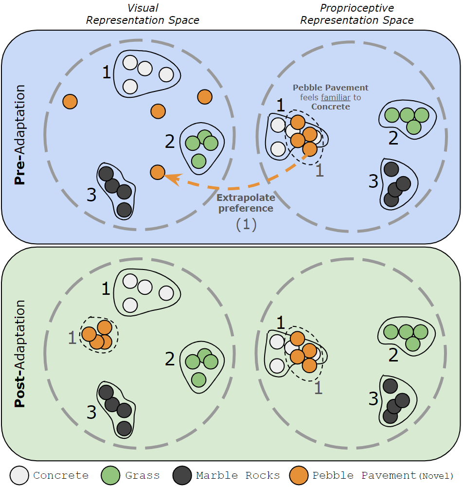
Equipping robots with the capability to handle novel terrain conditions for preference-aligned path planning is a challenging problem in visual navigation. Prior approaches to address this problem include collecting more expert demonstrations [4, 5, 6], labeling additional data [7, 8, 9], and utilizing hand-coded reward functions to assign traversability costs [10, 11, 12]. While these approaches have been successful at visual navigation, collecting more expert demonstration data and labeling may be labor-intensive and expensive, and utilizing hand-coded reward functions may not always align with operator preferences. We posit that in certain cases, while the terrain may look visually distinct in comparison to prior experience, similarities in the inertial-proprioceptive-tactile space may be leveraged to extrapolate operator preferences over such terrains, that the robot must adhere to. For instance, assuming a robot has experienced concrete pavement and marble rocks, and prefers the former over the latter (as expressed by the operator), when the robot experiences a visually novel terrain such as pebble pavement which feels inertially similar to traversing over concrete pavement, it is more likely that the operator might also prefer pebble pavement over marble rocks. While it is not possible to know the operator’s true preferences without querying them, we submit that in cases where the operator is unavailable, hypothesizing preferences through extrapolation from the inertial-proprioceptive-tactile space is a plausible way to estimate traversability preferences for novel terrains.
Leveraging the intuition of extrapolating operator preferences for visually distinct terrains that are familiar in the inertial-proprioceptive-tactile space (collectively known as proprioceptive for brevity), we introduce Preference extrApolation for Terrain-awarE Robot Navigation (patern) 111A preliminary version of this work was presented at the PT4R workshop at ICRA 2023 [13], a novel framework for extrapolating operator terrain preferences for visual navigation. patern learns a proprioceptive latent representation space from the robot’s prior experience and uses nearest-neighbor search in this space to estimate operator preferences for visually novel terrains. Fig. 1 provides an illustration of the intuition behind preference extrapolation in patern. We conduct extensive physical robot experiments on the task of preference-aligned off-road navigation, evaluating patern against state-of-the-art approaches, and find that patern is empirically successful with respect to preference alignment and in adapting to novel terrains and lighting conditions seen in the real world.
II RELATED WORK
In this section, we review related work in visual off-road navigation, with a focus on preference-aligned path planning.
II-A Supervised Methods
To learn terrain-aware navigation behaviors, several prior methods have been proposed that used supervised learning from large curated datasets [8, 9] as supervision to pixel-wise segment terrains [7]. Guan et al. [7] propose a transformer-based architecture (ganav) to segment terrains, and manually assign traversability costs for planning. While successful at preference-aligned navigation, fully-supervised methods suffer from domain shift on novel terrains and may require additional labeling.
II-B Self-Supervised Methods
To alleviate the need for large-scale datasets for visual navigation, several self-supervised learning methods have been proposed that learn from data collected on the robot [14]. Specifically, prior methods in this category have explored using inertial Fourier features [10], contact vibrations [15], proprioceptive feedback [16], odometry errors [12], future predictive models [11], acoustic features [17], and trajectory features [18] to learn traversability costs for visual navigation. While successful in several visual navigation tasks such as comfort-aware navigation [10], such methods use a hand-coded reward/cost model to solve a specific task and do not reason about operator preferences over terrains. In contrast with prior methods, patern utilizes the prior experience of the robot and extrapolates operator preferences to novel terrains.
Sikand et al. propose vrl-pap [6] in which both a visual representation and a visual preference cost are learned for preference-aligned navigation. Similarly, sterling[19] introduces a self-supervised representation learning approach for visual representation learning. However, a limitation for both vrl-pap and sterling is their dependence on additional human feedback when dealing with novel terrains — feedback that might not consistently be available during deployment. Distinct from vrl-pap and sterling, patern focuses on extrapolating operator preferences from known terrains to visually novel terrains.
III PRELIMINARIES
We formulate preference-aligned planning as a local path-planning problem in a state space , with an associated action space . The forward kino-dynamic transition function is denoted as and we assume that the robot has a reasonable model of (e.g., using parametric system identification [20] or a learned kino-dynamic model [21, 1, 22]), and that the robot can execute actions in with reasonable precision. For ground vehicles, a common choice for is , which represents the robot’s x and y position on the ground plane, as well as its orientation .
The objective of the path-planning problem can be expressed as finding the optimal trajectory to the goal , using any planner (e.g. a sampling-based motion planner like dwa [23]) while minimizing an objective function , . Here, denotes a sequence of states. The sequence of states in the optimal trajectory is then translated into a sequence of actions, using a 1-D time-optimal controller, to be played on the robot. For operator preference-aligned planning, the objective function is articulated as,
| (1) |
Here, denotes cost based on proximity of the robot’s state to the goal , while imparts a cost based on terrain preference. Crucially, is designed to capture operator preferences over different terrains; less preferred terrains incur a higher cost. Though earlier studies leverage human feedback to ascertain for unfamiliar terrains [6, 19], in this work, we hypothesize that in certain situations, operator preferences for novel terrains can be extrapolated from known terrains, obviating operator dependency during real-world deployment. Thus, our novel contribution is a self-supervised framework for extrapolating from known terrains to visually novel terrains by leveraging inertial-proprioceptive-tactile observations of a robot, without inquiring additional human feedback.
IV APPROACH
In this section, we present Preference extrApolation for Terrain-awarE Robot Navigation (patern), a novel framework for extrapolating operator preferences for preference-aligned navigation. We first detail an existing framework for terrain-preference-aligned visual navigation. We then introduce patern for self-supervised extrapolation of operator preferences from known terrains to visually novel terrains by leveraging proprioceptive feedback.
IV-A A Two-Step Framework for Preference-Aligned Planning
For real-time preference-aligned planning, inspired from earlier studies [6, 19], we postulate that can be estimated in a two-step approach from visual observations of patches of terrain at along . Let represent these observations. We denote as a projection operator that extracts visual observation of terrain at by yielding image patches from homography-transformed bird’s eye view images [6, 19]. First, a visual encoder, denoted as , maps from the RGB space to a latent vector such that observations from identical terrains cluster closely in and are distinct from those of differing terrains. Next, a real-valued preference utility is estimated from using a learned preference utility function trained with ranked preferences of terrains, derived either from demonstrations [6], or by active querying [19]. Adopting the popular formulation of Zucker et al. [24], we train the utility function with the margin-based ranking loss [25]. To estimate during planning, we employ an exponential cost formulation given by, , which we find works well in practice. This two-step framework for estimating has been utilized successfully in recent works [6, 19] for operator preference-aligned off-road navigation. Training details of the visual encoder and the utility function are provided in Section V.
While the above two-step framework effectively handles known terrains with pre-defined preferences, it faces challenges when the robot encounters visually novel terrains that lie beyond the training distribution of and . Towards addressing this problem, the primary contribution of our work is a self-supervised framework to extrapolate operator preferences to novel terrains and adapting and to ensure successful preference alignment.
IV-B Extrapolating Preferences for Visually Novel Terrains
Leveraging the intuition that in addition to visual appearance, operator preferences over terrains are likely also based on the “feel” of the underlying terrain such as bumpiness, stability, or traction, we posit that in many situations, operator preferences for novel terrains can be deduced by relating the proprioceptive modality to known terrains. Utilizing these rich, alternate data sources offers deeper insight into terrain properties, enabling us to extrapolate terrain preferences when direct operator feedback is unavailable. Upon initially encountering a novel terrain, before undergoing any adaptation, we designate this stage as the pre-adaptation phase. During this phase, the visual encoder and utility function operate based on previously known operator preferences. However, once preferences are extrapolated and the visual encoder and utility functions are subsequently retrained to adapt, the system progresses to the post-adaptation phase, as shown in Fig. 1.
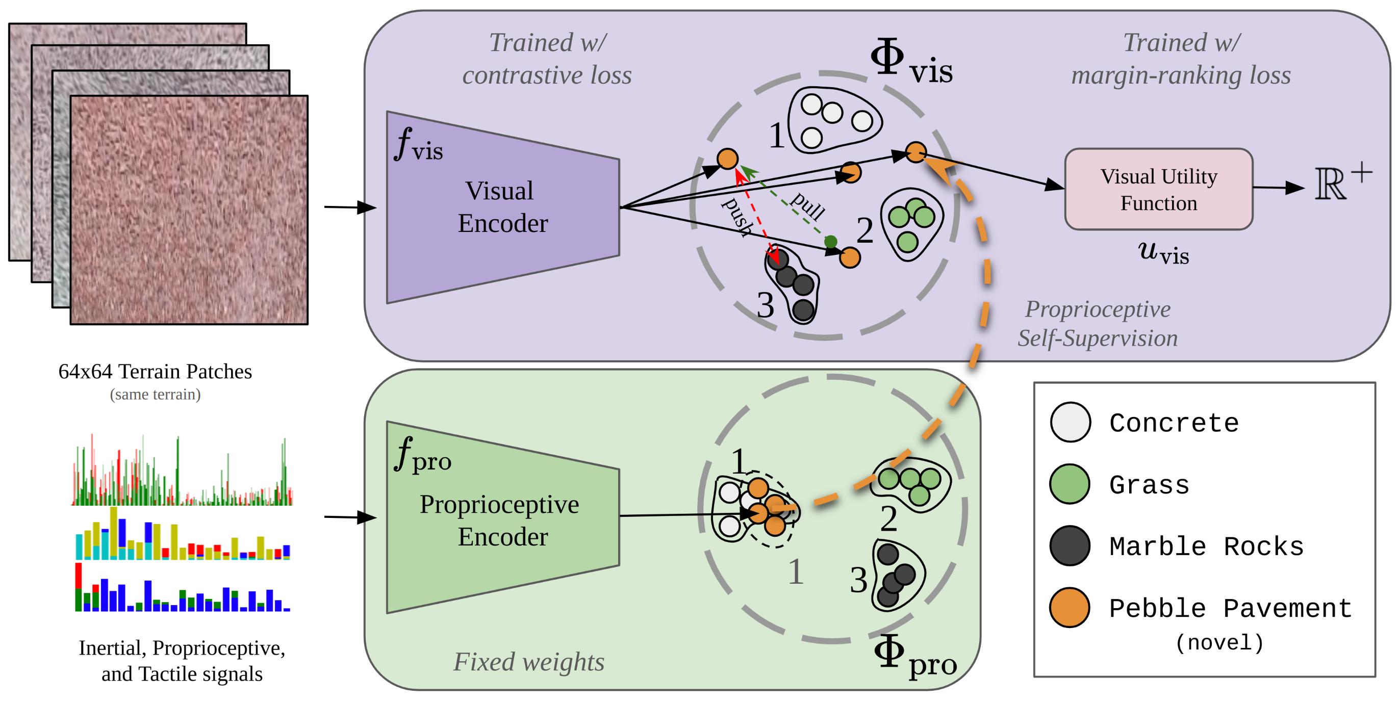
Inertial-Proprioceptive-Tactile Encoder and Utility Function: In patern, in addition to the visual encoder, we introduce a non-visual encoder that independently processes the inertial, proprioceptive (joint angles and velocities), and tactile feet data—collectively referred to as proprioception for brevity—observed by the robot as it traverses a terrain. This encoder maps proprioception observations into a proprioceptive representation space , such that representations of the same terrain are closely clustered whereas those of distinct terrains are farther apart. Additionally, a utility function maps the proprioceptive representation vector to a real-valued preference utility, similar to the visual utility function. Note that, to estimate during deployment, we only use and not since we cannot observe the proprioceptive components of a future state without traversing the terrain first.
Pre-Adaptation Phase: While traversing known terrains that are in-distribution, the visual and proprioceptive utility values tend to align closely. However, for visually novel terrains, discrepancies often emerge between the utility values predicted from the visual and proprioceptive modalities. In patern, we utilize the mean-squared error between the predicted utilities as a signal to detect visually novel, out-of-distribution terrains. Although any novelty detection mechanism can be integrated within patern, such as the uni-modal approach by Burda et al. [26], our primary focus is on a framework that extrapolates operator preferences for novel terrains. Moreover, any foundational approach employing the two-step framework for preference cost estimation [6, 19, 27], as elaborated in Subsection IV-A, can be utilized in the pre-adaptation phase. For clarity, we use the notation to represent the baseline algorithm in its unadapted state and to indicate the updated model in the post-adaptation phase.
Extrapolating Operator Preferences: Given a novel terrain segment for which operator preferences are unknown, we propose to self-supervise preference assignment by first clustering its proprioceptive representations and then associating it with the closest known existing cluster in , assigning the same operator preference as the known-cluster, as illustrated in Fig. 1. Following this self-supervised preference assignment, the visual encoder and visual utility function for novel terrain segments are finetuned by aggregating newly gathered experience with existing data.
V Implementation Details
In this section, we describe the implementation details of patern. We first describe data pre-processing, followed by training details in the pre-adaptation phase. Finally, we describe adapting the visual encoder and utility function using the extrapolated preference in patern.
V-A Data Pre-Processing
In tandem with the visual patch extraction process used in the projection operator as in prior methods [6, 19], for every state , we also extract a 2-second history of time-series inertial (angular velocities along the x and y-axes and linear acceleration in the z-axis), proprioceptive (joint angles and velocities), and tactile (feet depth penetration estimates) data. To ensure the resulting input data representation for training is independent of the length and phase of the signals, we compute statistical measures of center and spread as well as the power spectral density, and maintain that as the input. All the visual patches extracted with the projection operator and the non-visual data for each state are then tagged with their corresponding terrain name, given that each trajectory uniquely contains a particular terrain type. In addition to processing the recorded data in the pre-adaptation phase, a human operator is queried for a full-order ranking of terrain preference labels.
V-B Pre-Adaptation Training
We use a supervised contrastive learning formulation inspired by Sikand et al. [6] to train the baseline functions and , represented as neural networks.
Training the Encoders: Given labeled visual patches and proprioception data, we generate triplets for contrastive learning such that for any anchor, the positive pair is chosen from the same label and the negative pair is sourced from another label. Given such triplets, we use triplet loss [28] with a margin of to independently train the visual and proprioception encoders through mini-batch gradient descent using the AdamW optimizer. For the visual encoder, we use a 3-layer CNN of kernels, each followed by ReLU activations. This model, containing approximately 250k parameters, transforms size RGB image patches into an 8-dimensional vector representation . Similarly, our inertial encoder is comprised of a 3-layer MLP with ReLU activations, encompassing around 4k parameters, and maps proprioceptive inputs to an 8-dimensional vector . To mitigate the risk of overfitting, data is partitioned in a 75-25 split for training and validation, respectively.
Training the Utility Functions: In our setup, the utility function is represented as a two-layer MLP with ReLU non-linearity and output activation that maps an 8-dimensional vector into a singular non-negative real value. Given ranked operator preferences of the terrains, we follow Zucker et al. [24] and train the visual utility function using a margin-based ranking loss [25]. Furthermore, to ensure consistent predictions from and for both visual and non-visual observations at identical locations, we update parameters of using the loss . Here, denotes the stop-gradient operation, and and are the terrain representations from paired visual and non-visual data, respectively, at the same location.
The functions and prior to adaptation are collectively termed as , signifying their non-adapted state with respect to visually novel terrains. In our implementation, although we use supervised contrastive learning, in instances where explicit terrain labels might be absent, one can resort to self-supervised representation learning techniques, such as sterling [19], to derive and . patern can be applied regardless of the specific representation learning approach used.
V-C Preference Extrapolation Training
During deployment, if the robot encounters a visually novel terrain, both visual and inertial-proprioceptive-tactile data is recorded to be used in the adaptation phase in patern, aiding in preference extrapolation and subsequent model adaptation. We refer to this collected data as the adaptation-set. We extract paired visual and non-visual observations at identical locations from the adaptation-set and use to extract proprioceptive representations . We cluster samples of and perform a nearest-neighbor search against existing terrain clusters from the pre-adaptation dataset that is within a threshold . We set this threshold to be the same as the triplet margin value of 1.0 which we find to work well in practice. This procedure seeks a known terrain that “feels” similar to the novel terrain which then inherits the preference of its closest match. Following this self-supervised preference extrapolation framework, the adaptation-set is aggregated with the pre-adaptation training set, and the visual encoder is retrained using the procedure described in V-B. Additionally, the visual utility function is retrained with the extrapolated preference for the novel terrain. The updated functions and are collectively referred to as . Figure 2 illustrates retraining and preference extrapolation as described above.
VI EXPERIMENTS
In this section, we describe the physical robot experiments conducted to evaluate patern against other state-of-the-art visual off-road navigation algorithms. Specifically, our experiments are designed to explore the following questions:
-
()
Is patern capable of extrapolating operator preferences accurately to novel terrains?
-
()
How effectively does patern navigate under challenging lighting scenarios such as nighttime conditions?
-
()
How well does patern perform in large-scale real-world off-road conditions?
To study and , we execute a series of experiments consisting of short-scale outdoor navigation tasks. We then conduct a large-scale autonomous robot deployment along a 3-mile outdoor trail to qualitatively evaluate . We use the legged Boston Dynamics Spot robot for all experiments, equipped with a VectorNav VN100 IMU, front-facing Kinect RGB camera, Velodyne VLP-16 LiDAR for geometric obstacle detection, and a GeForce RTX 3060 mobile GPU. For local planning, we use an open-source sampling-based motion planner called graphnav [29] and augment its sample evaluation function with the inferred preference cost . For real-time planning, we run and on the onboard GPU.
| Approach | Environment | ||||
|---|---|---|---|---|---|
| 1 | 2-D | 2-N | 3-D | 3-N | |
| Geometric-Only | 2.87 | 2.34 | 2.34 | 3.44 | 3.69 |
| rca[10] | 0.84 | 0.91 | 6.061 | 2.57 | 7.37 |
| ganav[7] | 1.47 | 2.98 | 3.07 | 0.898 | 1.42 |
| Fully-Supervised | 0.58 | 0.44 | 2.735 | 0.763 | 6.747 |
| 0.54 | 2.31 | 2.29 | 2.305 | 5.76 | |
| - | 0.56 | 1.097 | 0.86 | 0.763 | |
| Approach | Environment | ||||
|---|---|---|---|---|---|
| 1 | 2-D | 2-N | 3-D | 3-N | |
| Geometric-Only | 44.0% | 68.8% | 68.8% | 43.6% | 43.6% |
| rca[10] | 100% | 97.3% | 67.4% | 100% | 99.4% |
| ganav[7] | 93.9% | 71.6% | 71.4% | 100% | 100% |
| Fully-Supervised | 100% | 100% | 71.7% | 100% | 93.6% |
| 100% | 94.1% | 71.6% | 81.3% | 100% | |
| - | 100% | 98.2% | 100% | 100% | |
VI-A Data Collection
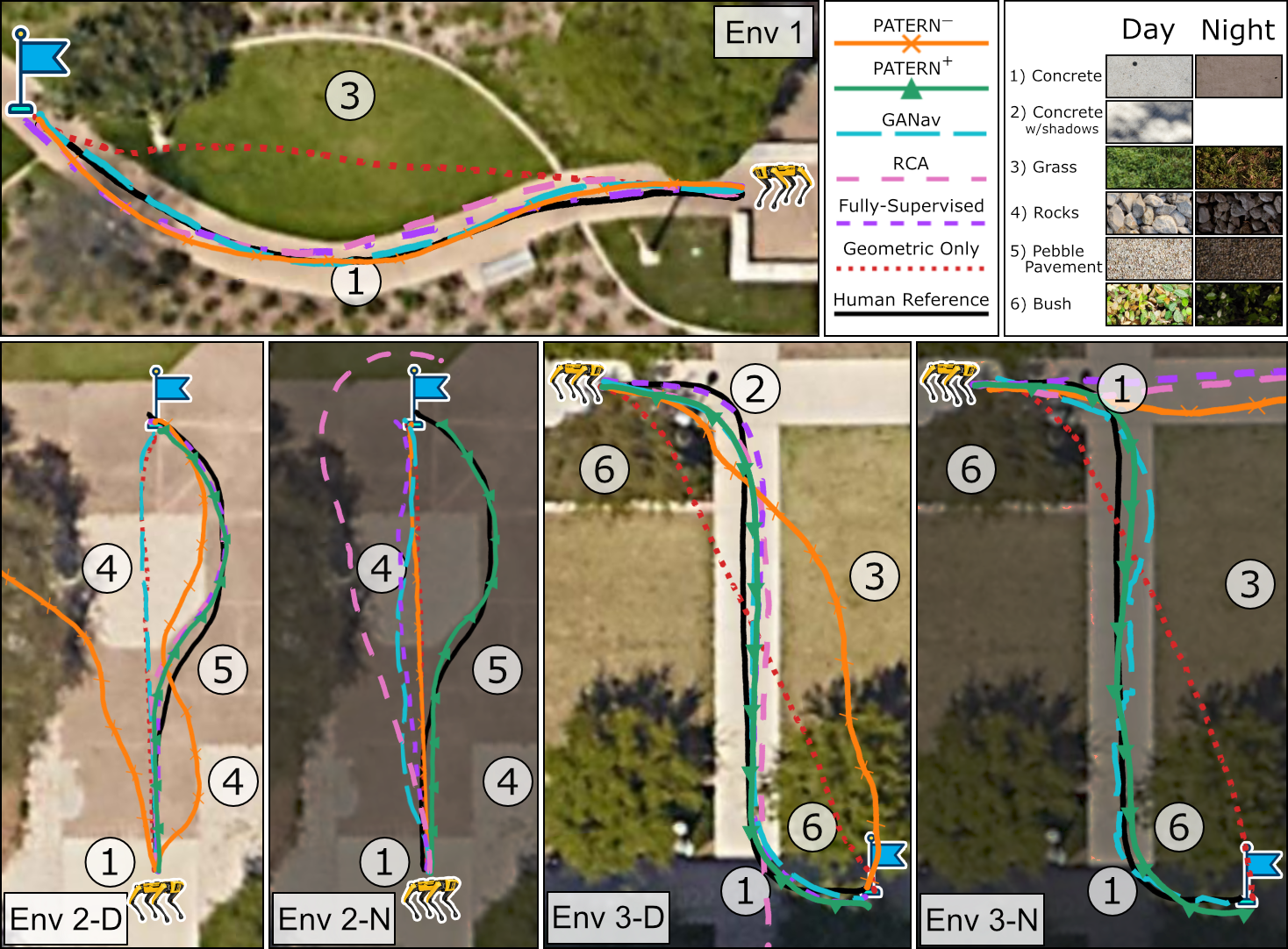
To collect labeled data for training , we manually teleoperated the robot across the UT Austin campus, gathering 8 distinct trajectories each across 3 terrains: concrete, grass, and marble rocks. Each trajectory, five minutes long, is exclusive to a single terrain type for ease of labeling and evaluation. The pre-adaptation training data was collected in the daytime under sunny conditions. Our evaluations then centered on two preference extrapolation scenarios: one, extending to new terrains such as pebble-pavement, concrete-with-shadows, and bushes, all experienced under varying daylight conditions ranging from bright sunlight to overcast skies, and two, adapting to nighttime illumination for familiar terrains that appear visually different. In our experiments, we use the preference order .
VI-B Quantitative Short-Scale Experiments
We evaluate patern in three environments with a variety of terrains within the UT Austin campus. We also test under two different lighting conditions, as shown in Fig. 3. The primary task for evaluation is preference-aligned visual off-road navigation, in which the robot is tasked with reaching a goal, while adhering to operator preferences over terrains.
To evaluate the effectiveness of patern, we compare it against five state-of-the-art baseline and reference approaches: Geometric-Only [29], a purely geometric obstacle-avoidant planner; RCA [10], a self-supervised traversability estimation algorithm based on ride-comfort; GANav, a semantic segmentation method 222\hrefhttps://github.com/rayguan97/GANav-offroadhttps://github.com/rayguan97/GANav-offroad trained on RUGD dataset [8]; Fully-Supervised, an approach that utilizes a visual terrain cost function comprehensively learned using supervised costs drawn from operator preferences; and lastly, Human Reference, which offers a preference-aligned reference trajectory where the robot is teleoperated by a human expert. To train the rca and Fully-Supervised baselines, in addition to the entirety of the pre-adaptation dataset on the 3 known terrains, we additionally collect 8 trajectories each on the novel terrains during daytime.
In each environment, we perform five trials of each method to ensure consistency in our evaluation. For each trial, the robot is relocalized in the environment, and the same goal location is fed to the robot. In the environments where fails to navigate in a preference-aligned manner, we run five trials of the self-supervised instance that uses experience gathered in these environments to extrapolate preferences to the novel terrains or novel lighting conditions. Fig. 3 shows the qualitative results of trajectories traced by each method in the outdoor experiments. Only one trajectory is shown for each method unless there is significant variation between trials. Table I shows quantitative results using the mean Hausdorff distance between a human reference trajectory and evaluation trajectories of each method. Table II shows quantitative results for the mean percentage of preference-aligned distance traversed in each trajectory. Note that both the reported metrics may be high if a method does not reach the goal but stays on operator-preferred terrain.
From the quantitative results, we see that, as expected, the approach is able to successfully navigate in an operator-preference-aligned manner in Env. 1, which did not contain any novel terrain types. However, fails to consistently reach the goal and/or navigate in alignment with operator preferences in the remaining environments. In the daytime experiments, Env. 2 contains a novel terrain (pebble pavement) absent from training data for , while Env. 3 contains both a novel terrain type (bush) and novel visual terrain appearances caused by tree shadows. In the nighttime experiments, all terrains contain novel visual appearances. Following deployments in Envs. 2 and 3, patern extrapolates terrain preferences for new visual data using the corresponding proprioceptive data to retrain environment-specific instances. In each environment that the model fails, the self-supervised model is able to successfully navigate to the respective goal in a preference-aligned manner, without requiring any additional operator feedback during deployment, addressing and . While the fully-supervised baseline more closely resembles the human reference trajectory compared to during the day in Envs. 2 and 3, unlike the fully-supervised approach, does not require operator preferences over all terrains and is capable of extrapolating to visually novel terrains.
VI-C Qualitative Large-Scale Experiment
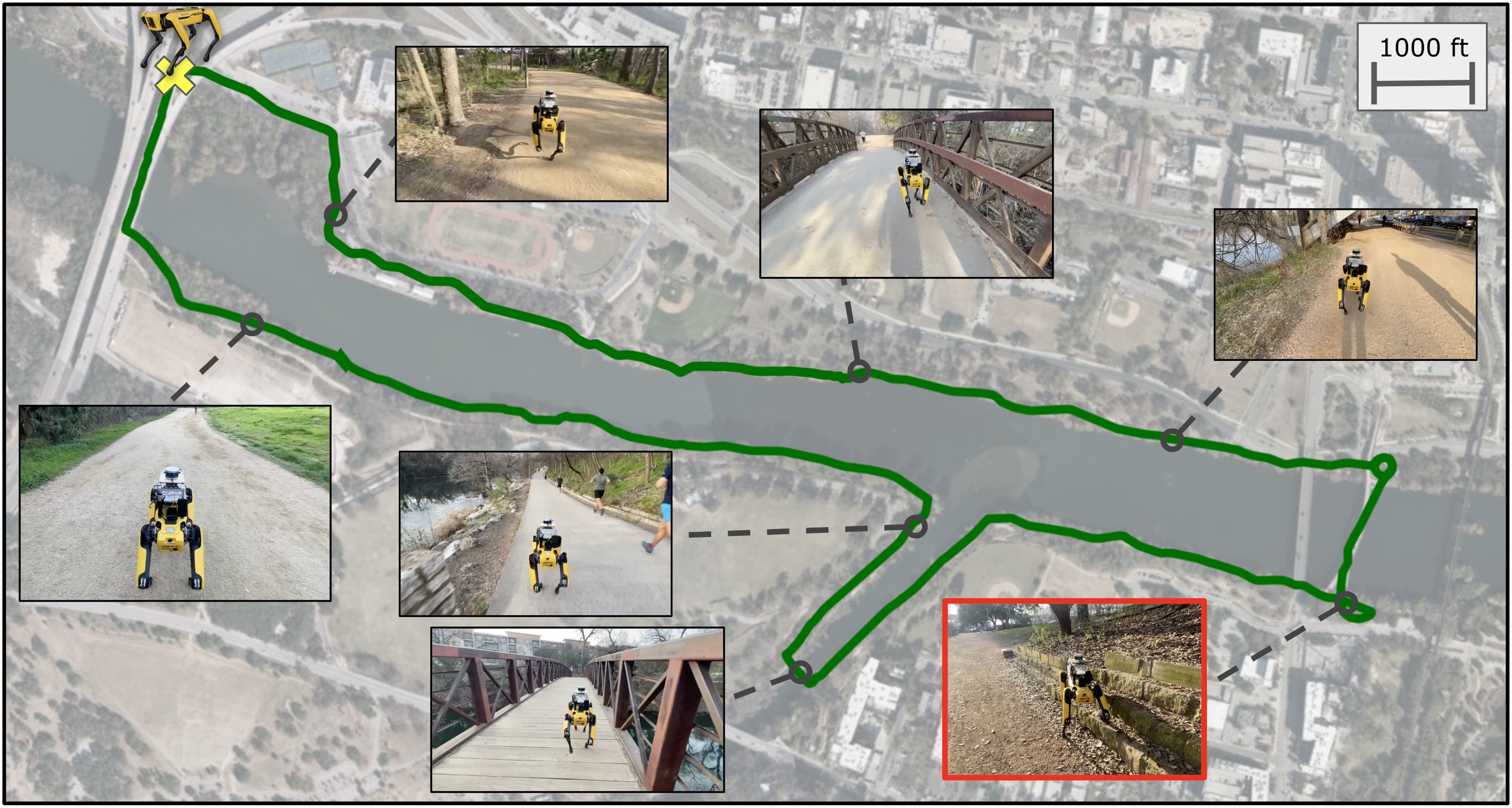
To investigate , we execute a large-scale autonomous deployment of patern along a challenging 3-mile off-road trail 333Ann and Roy Butler trail, Austin, TX, USA. The robot’s objective is to navigate in a terrain-aware manner on the trail by preferring dirt, gravel and concrete over bush, mulch, and rocks. Failure to navigate in a preference-aligned manner may cause catastrophic effects such as falling into the river next to the trail. An operator is allowed to temporarily take manual control of the robot only to prevent such catastrophic effects, adjust the robot’s heading for forks in the trail, or yield to pedestrians and cyclists. The model used for short-scale experiments is augmented with approximately five minutes of combined additional data for dirt, bush, and mulch terrains commonly seen in the trail. Following this preference extrapolation, the model is able to successfully navigate the 3-mile trail, while only requiring one human intervention. Fig. 4 shows the trajectory of the robot and a number of settings along the trail, including the single unexpected terrain-related intervention in the lower right corner, for the hour-long deployment. Additionally, we attach a video recording of the robot deployment444\hrefhttps://youtu.be/j7159pE0u6spatern deployed in the trail: https://youtu.be/j7159pE0u6s. This large-scale study addresses by qualitatively demonstrating the effectiveness of patern in scaling to real-world off-road conditions.
VII LIMITATIONS AND FUTURE WORK
patern uses similarities between novel and known terrains in its learned proprioception representation space to extrapolate preferences. Thus, patern needs to have had experiences with terrains bearing close inertial-proprioceptive-tactile resemblances for successful extrapolation. A noticeable limitation is that if a terrain evoking similar proprioceptive features has not been encountered before, patern might not be able to extrapolate preferences. Additionally, patern utilizes non-visual observations that require a robot to physically drive over terrains, which may be unsafe or infeasible in certain cases. Extending patern with depth sensors to handle non-flat terrains is a promising direction for future work.
VIII CONCLUSION
In this work, we present Preference extrApolation for Terrain-awarE Robot Navigation (patern), a novel approach to extrapolate human preferences for novel terrains in visual off-road navigation. patern learns an inertial-proprioceptive-tactile representation space to detect similarities between visually novel terrains and the set of known terrains. Through this self-supervision, patern successfully extrapolates operator preferences for visually novel terrain segments, without requiring additional human feedback. Through extensive physical robot experiments in challenging outdoor environments in varied lighting conditions, we find that patern successfully extrapolates preferences for visually novel terrains and is scalable to real-world off-road conditions.
References
- [1] H. Karnan, K. S. Sikand, P. Atreya, S. Rabiee, X. Xiao, G. Warnell, P. Stone, and J. Biswas, “Vi-ikd: High-speed accurate off-road navigation using learned visual-inertial inverse kinodynamics,” in 2022 IEEE/RSJ International Conference on Intelligent Robots and Systems (IROS). IEEE, 2022, pp. 3294–3301.
- [2] T. Miki, J. Lee, J. Hwangbo, L. Wellhausen, V. Koltun, and M. Hutter, “Learning robust perceptive locomotion for quadrupedal robots in the wild,” Science Robotics, vol. 7, no. 62, p. eabk2822, 2022.
- [3] X. Xiao, B. Liu, G. Warnell, and P. Stone, “Motion planning and control for mobile robot navigation using machine learning: a survey,” 2020.
- [4] M. Bojarski, D. Del Testa, D. Dworakowski, B. Firner, B. Flepp, P. Goyal, L. D. Jackel, M. Monfort, U. Muller, J. Zhang, X. Zhang, J. Zhao, and K. Zieba, “End to end learning for self-driving cars,” 2016.
- [5] Y. LeCun, U. Muller, J. Ben, E. Cosatto, and B. Flepp, “Off-road obstacle avoidance through end-to-end learning,” in Proceedings of the 18th International Conference on Neural Information Processing Systems, ser. NIPS’05. Cambridge, MA, USA: MIT Press, 2005, p. 739–746.
- [6] K. S. Sikand, S. Rabiee, A. Uccello, X. Xiao, G. Warnell, and J. Biswas, “Visual representation learning for preference-aware path planning,” in 2022 International Conference on Robotics and Automation (ICRA). IEEE, 2022, pp. 11 303–11 309.
- [7] T. Guan, D. Kothandaraman, R. Chandra, A. J. Sathyamoorthy, K. Weerakoon, and D. Manocha, “Ga-nav: Efficient terrain segmentation for robot navigation in unstructured outdoor environments,” IEEE Robotics and Automation Letters, vol. 7, no. 3, pp. 8138–8145, 2022.
- [8] M. Wigness, S. Eum, J. G. Rogers, D. Han, and H. Kwon, “A rugd dataset for autonomous navigation and visual perception in unstructured outdoor environments,” in 2019 IEEE/RSJ International Conference on Intelligent Robots and Systems (IROS). IEEE, 2019, pp. 5000–5007.
- [9] P. Jiang, P. Osteen, M. Wigness, and S. Saripalli, “Rellis-3d dataset: Data, benchmarks and analysis,” 2020.
- [10] X. Yao, J. Zhang, and J. Oh, “Rca: Ride comfort-aware visual navigation via self-supervised learning,” in 2022 IEEE/RSJ International Conference on Intelligent Robots and Systems (IROS). IEEE, 2022, pp. 7847–7852.
- [11] G. Kahn, P. Abbeel, and S. Levine, “Badgr: An autonomous self-supervised learning-based navigation system,” IEEE Robotics and Automation Letters, vol. 6, no. 2, pp. 1312–1319, 2021.
- [12] A. J. Sathyamoorthy, K. Weerakoon, T. Guan, J. Liang, and D. Manocha, “Terrapn: Unstructured terrain navigation using online self-supervised learning,” 2022.
- [13] E. Yang, H. Karnan, G. Warnell, P. Stone, and J. Biswas, “Wait, that feels familiar: Learning to extrapolate human preferences for preference-aligned path planning,” in ICRA2023 Workshop on Pretraining for Robotics (PT4R), 2023.
- [14] J. Frey, M. Mattamala, N. Chebrolu, C. Cadena, M. Fallon, and M. Hutter, “Fast traversability estimation for wild visual navigation,” 2023.
- [15] C. A. Brooks and K. D. Iagnemma, “Self-supervised classification for planetary rover terrain sensing,” in 2007 IEEE aerospace conference. IEEE, 2007, pp. 1–9.
- [16] A. Loquercio, A. Kumar, and J. Malik, “Learning visual locomotion with cross-modal supervision,” 2022.
- [17] J. Zürn, W. Burgard, and A. Valada, “Self-supervised visual terrain classification from unsupervised acoustic feature learning,” IEEE Transactions on Robotics, vol. 37, no. 2, pp. 466–481, 2020.
- [18] L. Wellhausen, A. Dosovitskiy, R. Ranftl, K. Walas, C. Cadena, and M. Hutter, “Where should i walk? predicting terrain properties from images via self-supervised learning,” IEEE Robotics and Automation Letters, vol. 4, no. 2, pp. 1509–1516, 2019.
- [19] H. Karnan, E. Yang, D. Farkash, G. Warnell, J. Biswas, and P. Stone, “Self-supervised terrain representation learning from unconstrained robot experience,” in ICRA2023 Workshop on Pretraining for Robotics (PT4R), 2023.
- [20] N. Seegmiller, F. Rogers-Marcovitz, G. Miller, and A. Kelly, “Vehicle model identification by integrated prediction error minimization,” The International Journal of Robotics Research, vol. 32, no. 8, pp. 912–931, 2013.
- [21] X. Xiao, J. Biswas, and P. Stone, “Learning Inverse Kinodynamics for Accurate High-Speed Off-Road Navigation on Unstructured Terrain,” arXiv e-prints, p. arXiv:2102.12667, Feb. 2021.
- [22] P. Atreya, H. Karnan, K. S. Sikand, X. Xiao, S. Rabiee, and J. Biswas, “High-speed accurate robot control using learned forward kinodynamics and non-linear least squares optimization,” in Intelligent Robots and Systems (IROS), IEEE/RSJ International Conference on. IEEE, 2022, pp. 11 789–11 795.
- [23] D. Fox, W. Burgard, and S. Thrun, “The dynamic window approach to collision avoidance,” IEEE Robotics & Automation Magazine, vol. 4, no. 1, pp. 23–33, 1997.
- [24] M. Zucker, N. Ratliff, M. Stolle, J. Chestnutt, J. A. Bagnell, C. G. Atkeson, and J. Kuffner, “Optimization and learning for rough terrain legged locomotion,” The International Journal of Robotics Research, vol. 30, no. 2, pp. 175–191, 2011.
- [25] D. P. Vassileios Balntas, Edgar Riba and K. Mikolajczyk, “Learning local feature descriptors with triplets and shallow convolutional neural networks,” in Proceedings of the British Machine Vision Conference (BMVC), E. R. H. Richard C. Wilson and W. A. P. Smith, Eds. BMVA Press, September 2016, pp. 119.1–119.11. [Online]. Available: https://dx.doi.org/10.5244/C.30.119
- [26] Y. Burda, H. Edwards, A. Storkey, and O. Klimov, “Exploration by random network distillation,” 2018.
- [27] D. S. Brown, W. Goo, and S. Niekum, “Better-than-demonstrator imitation learning via automatically-ranked demonstrations,” in Conference on robot learning. PMLR, 2020, pp. 330–359.
- [28] F. Schroff, D. Kalenichenko, and J. Philbin, “Facenet: A unified embedding for face recognition and clustering,” in Proceedings of the IEEE conference on computer vision and pattern recognition, 2015, pp. 815–823.
- [29] J. Biswas, “Amrl autonomy stack,” https://github.com/ut-amrl/graph_navigation, 2013.