Self-Supervised Masked Digital Elevation Models Encoding for Low-Resource Downstream Tasks
Abstract
The lack of quality labeled data is one of the main bottlenecks for training Deep Learning models. As the task increases in complexity, there is a higher penalty for overfitting and unstable learning. The typical paradigm employed today is Self-Supervised learning, where the model attempts to learn from a large corpus of unstructured and unlabeled data and then transfer that knowledge to the required task. Some notable examples of self-supervision in other modalities are BERT for Large Language Models, Wav2Vec for Speech Recognition, and the Masked AutoEncoder for Vision, which all utilize Transformers to solve a masked prediction task. GeoAI is uniquely poised to take advantage of the self-supervised methodology due to the decades of data collected, little of which is precisely and dependably annotated. Our goal is to extract building and road segmentations from Digital Elevation Models (DEM) that provide a detailed topography of the earths surface. The proposed architecture is the Masked Autoencoder pre-trained on ImageNet (with the limitation that there is a large domain discrepancy between ImageNet and DEM) with an UperNet Head for decoding segmentations. We tested this model with 450 and 50 training images only, utilizing roughly 5% and 0.5% of the original data respectively. On the building segmentation task, this model obtains an 82.1% Intersection over Union (IoU) with 450 Images and 69.1% IoU with only 50 images. On the more challenging road detection task the model obtains an 82.7% IoU with 450 images and 73.2% IoU with only 50 images. Any hand-labeled dataset made today about the earths surface will be immediately obsolete due to the constantly changing nature of the landscape. This motivates the clear necessity for data-efficient learners that can be used for a wide variety of downstream tasks.
Keywords Self-Supervised Learning, Deep Learning, Masked Image Modeling, GeoAI, DEM, Segmentation, Small-Data
1 Introduction
Deep Learning has provided powerful and highly predictive models for a wide variety of tasks, but it often comes at the cost of the immense amount of data needed to curtail overfitting and promote generalization Schmitt et al. (2020). The onset of the Transfer Learning methodology has opened these tools to solve more niche problems with smaller datasets Pires de Lima and Marfurt (2019). A common strategy is to utilize a model that has been trained to perform some objective and exploit its feature extraction capabilities to fine-tune it toward another problem.
Unfortunately, many of these pre-trained models are trained in a supervised fashion, using labeled data, which may not be available for some areas of interest Schmitt et al. (2020). Ideally, features should be learned through the dataset itself without any labels. This technique of Self-Supervised pre-training has been the current method of building a model that generalizes features of the data which can be used for any downstream tasks Wang et al. (2021). There are two main features that enable these models to be so efficient: (i) utilizing an encoder network that ingests randomly masked data and a lightweight decoder network that attempts to reconstruct the masked portions, in this process, the model is forced to learn global relationships that can be utilized in downstream tasks. (ii): employing a Transformer architecture Vaswani et al. (2017) which encodes relationships between tokens via the Attention mechanism. In NLP and Speech, the attention gives the model a temporal awareness by learning the relationships between words. For Vision, the model encodes which patches of the image are most related to each other, offering powerful global spatial awareness. The specific variant we are using in this paper is the Masked AutoEncoder He et al. (2021).
The contribution of this paper is to evaluate the use of the Masked Autoencoder pre-trained on ImageNet for different downstream segmentation tasks of digital elevation models (i.e., segmenting building footprints and roads), particularly with differences in the learning domain between traditional optical images and digital elevation data (e.g., single channel with large dynamic range).
Left - DEM, Right - Label
2 Related Works
Several researchers utilized weakly supervised learning to avoid the lack of training datasets. For example, Wei and Ji (2021) applied weakly supervised training successfully for the task of road segmentation. Similarly, Soliman et al. (2022) evaluated an existing dataset to train models to extract building footprints from DEM and Wang et al. (2020) used a single labeled pixel per image to segment optical satellite images.
However, advances in utilizing self-supervised learning strategies in modeling language Devlin et al. (2018) and in computer vision Dosovitskiy et al. (2020) has motivated researchers to evaluate the self-supervised approach to train deep learning models on feature representations from geospatial and remote sensing data without human annotation. For example, Gao et al. (2022) demonstrated that a masked autoencoder is capable of outperforming supervised methods in different downstream tasks by learning how to reconstruct masked patches in optical satellite images. Zhu et al. (2023) proposed SpectralMAE, which is a spectral-masked autoencoder model designed to reconstruct hyperspectral images. Similarly, Scheibenreif et al. (2023) applied a masked autoencoder for Hyperspectral Image Classification.Wang et al. (2021) developed Mask DeepLab as a model for change detection by teaching the model how to construct time difference images, while Reed et al. (2022) demonstrated how to incorporate a sense of geographic scale in MAE learning.
However, there is a lack of studies evaluating self-supervised models in segmenting Digital Elevation Models. Especially since DEMs have contrasting characteristics to optical images and could be subject to resolution loss during data pre-processing, for example, by the loss of their large dynamic from local normalization. In addition, it is important to evaluate the need for pre-training MAE on a large corpus of DEMs similar to some of the foundation models in optical remote sensing Sun et al. (2022).
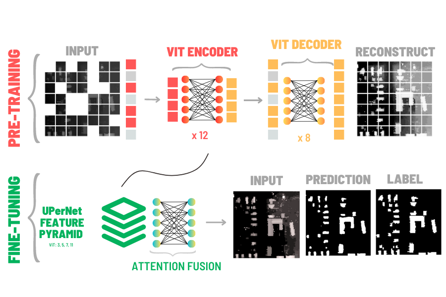
3 Model Architecture Details
We utilized the base Masked AutoEncoder (MAE) that was pre-trained on ImageNet Russakovsky et al. (2014a) as our backbone to our segmentation model. The original images are 224 x 224 pixels and the ViT Patch Embedding module splits this into 192 patches each with shape 16 x 16 pixels. Each patch of the image is passed through a linear layer to encode it as a token with embedding dimension of 768. In the masking step, 75% of the tokens are randomly hidden. The Encoder portion of the MAE has 12 transformer blocks and each block has 12 heads in the Multi-Headed Attention computation. The MAE opts for a light weight decoder (rather than a symmetrical encoder/decoder architecture) so the token embeddings are first reduced in size from 768 to 512. There are 8 transformer blocks in the decoder with each having 16 heads. Another linear layer takes the output from the decoder and returns the tokens back to the original shape (16x16) so we can perform a reconstruction loss of the masked tokens.
While the MAE backbone is used to encode our images, an additional module is necessary to actually generate segmentation masks. To perform this task we will utilize the UperNet head. The UperNet architecture employs a feature pyramid network (FPN) Lin et al. (2016) that fuses information extracted from different layers of the Masked Autoencoder (specifically transformer blocks 3, 5, 7, 11). A similar architecture was previously used in Li et al. (2023) for extraction of permafrost features from the arctic, although with a convolutional ResNet50 backbone. All implementation was done with the PyTorch Framework Russakovsky et al. (2014b) and MMSegmentation Contributors (2020).
All models were trained for 3000 iterations (with validation at every 150 iterations) with a batch size of 8, and the best validation accuracy is presented. The backbone was frozen and only the UperNet head was tuned for the specific segmentation task. The AdamW optimizer was used with a weight decay of 0.05 along with a Polynomial Learning Rate scheduler to help curtail overfitting and promote smooth learning on small datasets. We also used a pixel-wise categorical cross entropy for our loss function with added class weights due to the large imbalance of background pixels versus the label pixels. For comparison, we additionally trained a UNet Ronneberger et al. (2015) model from scratch for the same small-data tasks to compare against some more traditional methods.
4 Results and Discussion
We look at how our model, a frozen MAE, and a trained UperNet Head, compare against the more typical UNet model for this task. We took samples of 450, 200, 50, and 10 images from both the visually-labeled road and building training datasets with a constant 50 images for validation. The IoU for the predicted class for each model is presented in table 1.
| Building and Road Segmentation IoU | ||||
|---|---|---|---|---|
| Num. Samples | MAE (B) | UNet (B) | MAE (R) | UNet (R) |
| 10 | 55.5% | 27.9% | 37.1% | 23.4% |
| 50 | 69.1% | 55.0% | 73.2% | 70.4% |
| 200 | 76.1% | 68.2% | 81.3% | 77.9% |
| 450 | 82.1% | 76.5% | 82.7% | 78.4% |
Our methods provide reliable segmentation performance on very few samples. On the building segmentation task, we obtain a performance of 55.5% IoU with only 10 images, about 50% better than a UNet. On the Road segmentation task, training on 10 images doesn’t provides a dependable model. As we increase the number of training samples in both road and building segmentation, our IoU continues to increase with the MAE consistently outperforming the UNet.
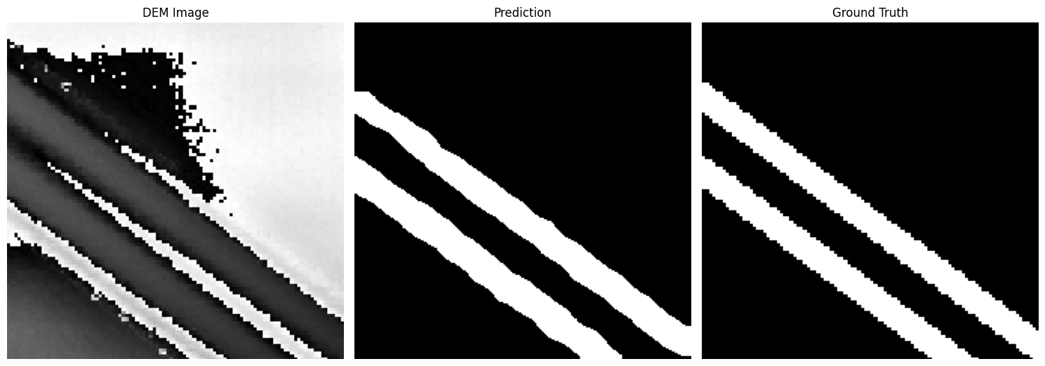
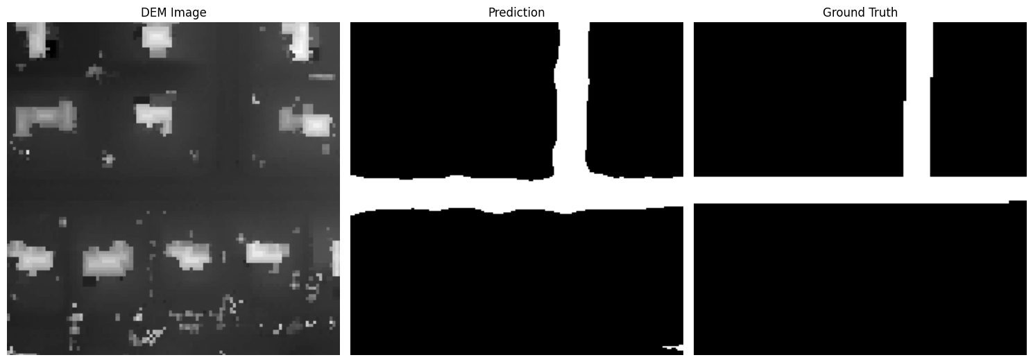
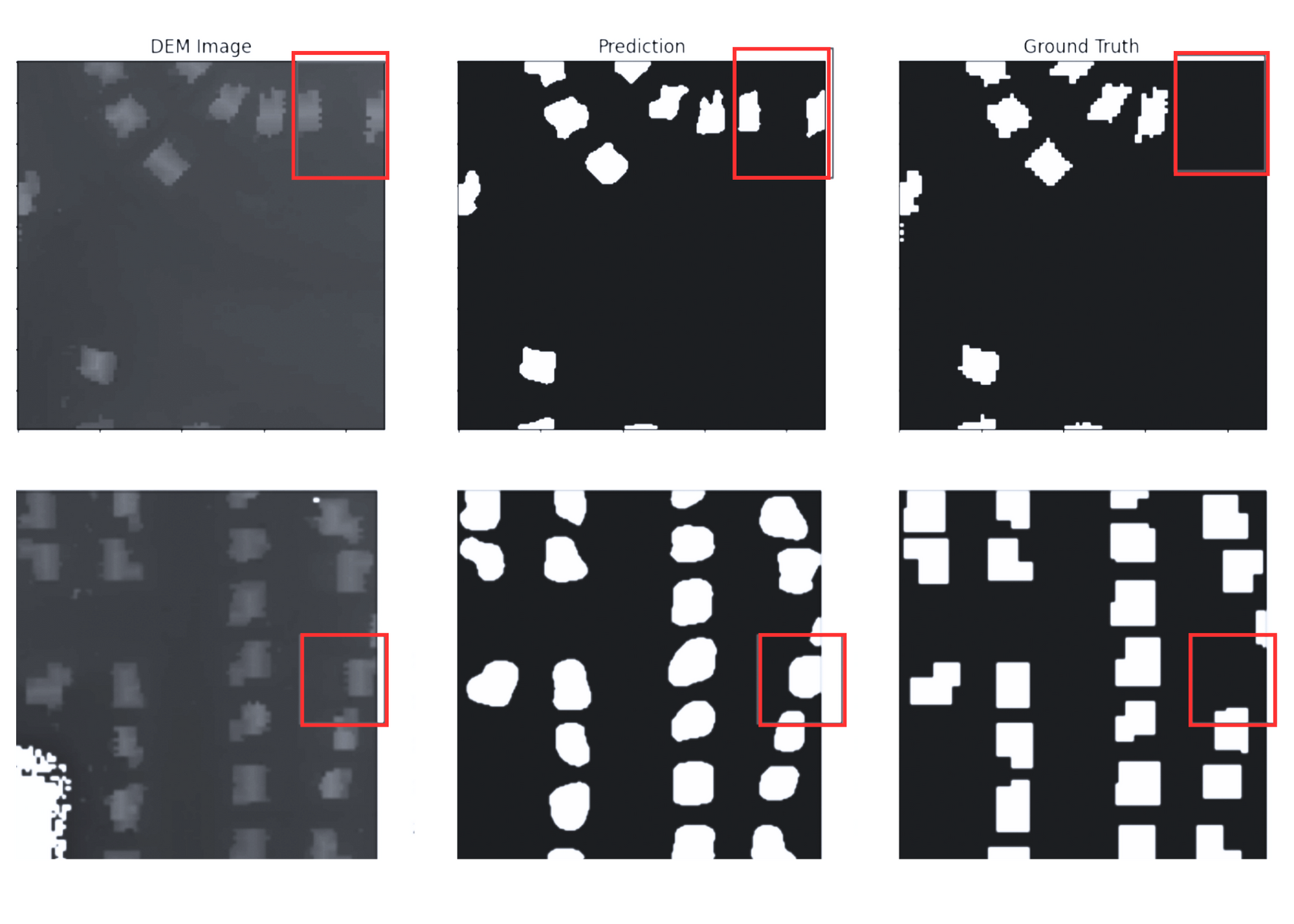
The road segmentation task, specifically, has varying levels of difficulty depending on the nature of the landscape and the elevation difference. The original data were elevation rasters with a high dynamic range. In flat lands with well-defined roads like highways, (i.e. Figure 3), the streets are much more clearly separated after locally normalizing the image between the maximum and minimum elevation. On the other hand, in residential areas (i.e. Figure 4), normalizing with the max elevations on top of buildings conceals the roads. Even so, our model detects roads in these challenging conditions.
Left - DEM, Middle - Prediction, Right - Label
Left - DEM, Middle - Prediction, Right - Label
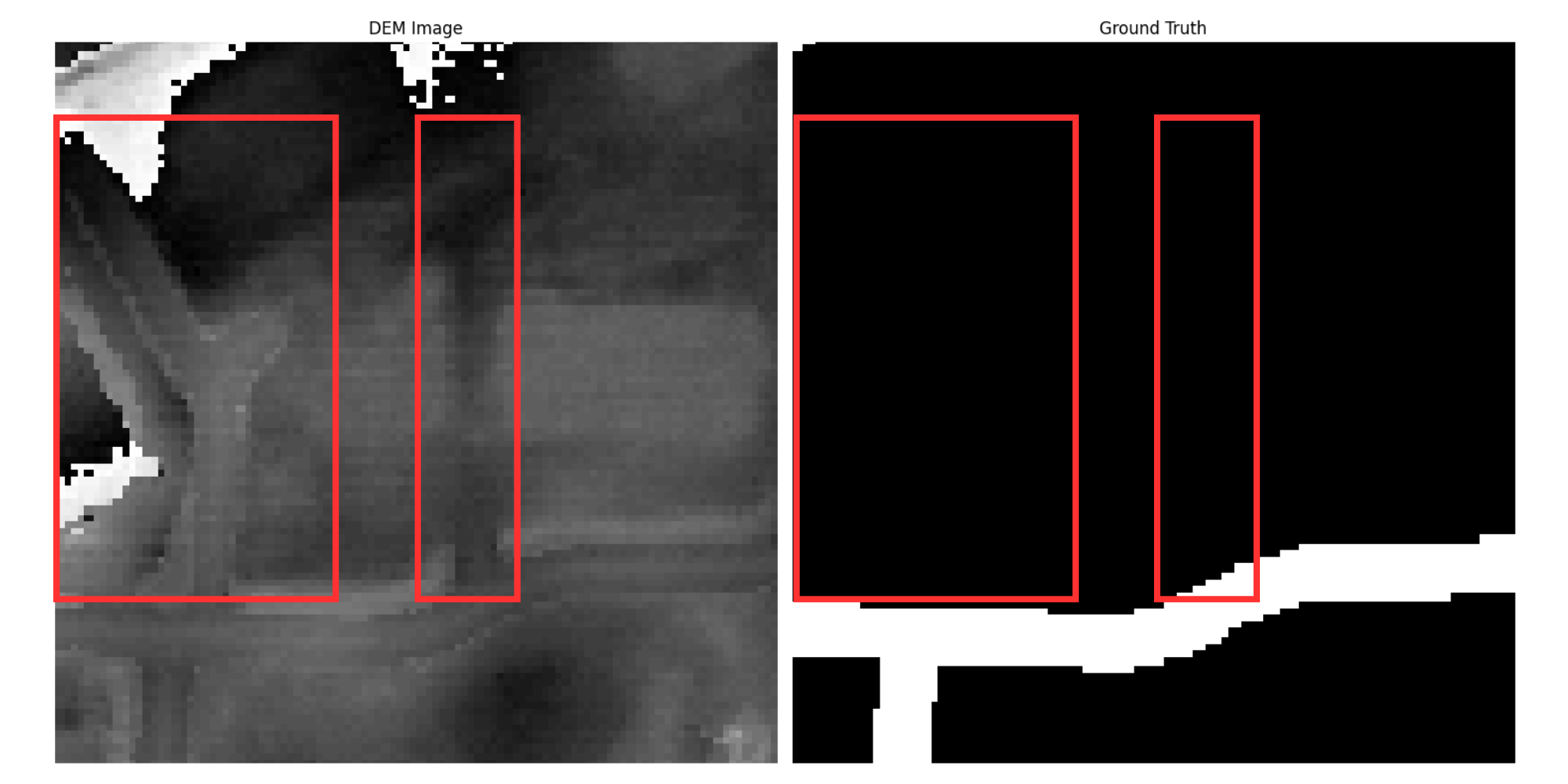
We should also notice that although the manually labeled dataset was curated carefully, there are a few errors related to the alignment of the visual label dataset and the tiling, especially around the edges of the manually labeled data. As we can see in Figure 5, labels may be missing for some of the buildings. Nevertheless, our model is capable of predicting them accurately. In addition, road labels currently have an average width, however, road widths vary within and between cities.
Left - DEM, Middle - Prediction, Right - Label
| Noisy Labels Segmentation IoU | |
| MAE | 78.2% |
| UNet | 74.4% |
Noisy data can sometimes be unavoidable without a significant effort of continuously maintaining labels; therefore, we wanted to test the robustness of our model by training on a large amount of variable quality road segmentation. As shown above, we had roughly 10,000 training images of roads, 500 of which were visually inspected for completeness. In order to test the robustness of our model, we trained on the entire set of images but validated on the visually labeled/inspected validation set to allow for comparison to other experiments. As shown in Table 2, the MAE and UNet obtain a 78.2% and 74.4% IoU respectively, which downgraded the performance compared to our previous training on 450 high-quality images. This offers some additional evidence that using a smaller sample of quality data outperforms having a large corpus of unverified data (Weakly supervised).
5 Conclusions
We present self-supervised learning as an effective strategy to perform various downstream tasks with limited data resources. We obtained encouraging results using an ImageNet pre-trained backbone, even with the domain discrepancy from DEM. Following this proof-of-concept, we plan to pre-train an MAE on a large corpus of DEM datasets so the numerical encoding are more salient and provides a substantial performance jump. In the future, this model can be used for various downstream tasks: (1) Segmentation with the UperNet head, (2) Classification with a simple linear head, and (3) Object Detection using MAE as a backbone to the Detectron architecture Li et al. (2022). Training a DEM-specific MAE is likely to result in enhancing the model performance as there is evidence that scaling the model up provides significant gains He et al. (2021). Access to an adequate amount of DEM data and compute environments will enable pre-training large Geo-AI models to provide a data-efficient DEM encoder and make possible low-resource learning for Geospatial tasks.
6 Acknowledgements
This work is supported by funding from the National Science Foundation, award number 1927729.
References
- Schmitt et al. [2020] Michael Schmitt, Jonathan Prexl, Patrick Ebel, Lukas Liebel, and Xiao Xiang Zhu. Weakly supervised semantic segmentation of satellite images for land cover mapping–challenges and opportunities. arXiv preprint arXiv:2002.08254, 2020.
- Pires de Lima and Marfurt [2019] Rafael Pires de Lima and Kurt Marfurt. Convolutional neural network for remote-sensing scene classification: Transfer learning analysis. Remote Sensing, 12(1):86, 2019.
- Wang et al. [2021] Yanheng Wang, Lianru Gao, Danfeng Hong, Jianjun Sha, Lian Liu, Bing Zhang, Xianhui Rong, and Yonggang Zhang. Mask deeplab: End-to-end image segmentation for change detection in high-resolution remote sensing images. International Journal of Applied Earth Observation and Geoinformation, 104:102582, 2021.
- Vaswani et al. [2017] Ashish Vaswani, Noam Shazeer, Niki Parmar, Jakob Uszkoreit, Llion Jones, Aidan N. Gomez, Lukasz Kaiser, and Illia Polosukhin. Attention is all you need. CoRR, abs/1706.03762, 2017. URL http://arxiv.org/abs/1706.03762.
- He et al. [2021] Kaiming He, Xinlei Chen, Saining Xie, Yanghao Li, Piotr Dollár, and Ross B. Girshick. Masked autoencoders are scalable vision learners. CoRR, abs/2111.06377, 2021. URL https://arxiv.org/abs/2111.06377.
- Wei and Ji [2021] Yao Wei and Shunping Ji. Scribble-based weakly supervised deep learning for road surface extraction from remote sensing images. IEEE Transactions on Geoscience and Remote Sensing, 2021.
- Soliman et al. [2022] Aiman Soliman, Yifan Chen, Shirui Luo, Rauf Makharov, and Volodymyr Kindratenko. Weakly supervised segmentation of buildings in digital elevation models. IEEE Geoscience and Remote Sensing Letters, 19:1–5, 2022. doi:10.1109/LGRS.2022.3177160.
- Wang et al. [2020] Sherrie Wang, William Chen, Sang Michael Xie, George Azzari, and David B Lobell. Weakly supervised deep learning for segmentation of remote sensing imagery. Remote Sensing, 12(2):207, 2020.
- Devlin et al. [2018] Jacob Devlin, Ming-Wei Chang, Kenton Lee, and Kristina Toutanova. BERT: pre-training of deep bidirectional transformers for language understanding. CoRR, abs/1810.04805, 2018. URL http://arxiv.org/abs/1810.04805.
- Dosovitskiy et al. [2020] Alexey Dosovitskiy, Lucas Beyer, Alexander Kolesnikov, Dirk Weissenborn, Xiaohua Zhai, Thomas Unterthiner, Mostafa Dehghani, Matthias Minderer, Georg Heigold, Sylvain Gelly, Jakob Uszkoreit, and Neil Houlsby. An image is worth 16x16 words: Transformers for image recognition at scale. CoRR, abs/2010.11929, 2020. URL https://arxiv.org/abs/2010.11929.
- Gao et al. [2022] Yuan Gao, Xiaojuan Sun, and Chao Liu. A general self-supervised framework for remote sensing image classification. Remote Sensing, 14(19):4824, 2022.
- Zhu et al. [2023] Lingxuan Zhu, Jiaji Wu, Wang Biao, Yi Liao, and Dandan Gu. Spectralmae: Spectral masked autoencoder for hyperspectral remote sensing image reconstruction. Sensors, 23(7):3728, 2023.
- Scheibenreif et al. [2023] Linus Scheibenreif, Michael Mommert, and Damian Borth. Masked vision transformers for hyperspectral image classification. In Proceedings of the IEEE/CVF Conference on Computer Vision and Pattern Recognition, pages 2165–2175, 2023.
- Reed et al. [2022] Colorado J Reed, Ritwik Gupta, Shufan Li, Sarah Brockman, Christopher Funk, Brian Clipp, Salvatore Candido, Matt Uyttendaele, and Trevor Darrell. Scale-mae: A scale-aware masked autoencoder for multiscale geospatial representation learning. arXiv preprint arXiv:2212.14532, 2022.
- Sun et al. [2022] Xian Sun, Peijin Wang, Wanxuan Lu, Zicong Zhu, Xiaonan Lu, Qibin He, Junxi Li, Xuee Rong, Zhujun Yang, Hao Chang, et al. Ringmo: A remote sensing foundation model with masked image modeling. IEEE Transactions on Geoscience and Remote Sensing, 2022.
- Russakovsky et al. [2014a] Olga Russakovsky, Jia Deng, Hao Su, Jonathan Krause, Sanjeev Satheesh, Sean Ma, Zhiheng Huang, Andrej Karpathy, Aditya Khosla, Michael S. Bernstein, Alexander C. Berg, and Li Fei-Fei. Imagenet large scale visual recognition challenge. CoRR, abs/1409.0575, 2014a. URL http://arxiv.org/abs/1409.0575.
- Lin et al. [2016] Tsung-Yi Lin, Piotr Dollár, Ross B. Girshick, Kaiming He, Bharath Hariharan, and Serge J. Belongie. Feature pyramid networks for object detection. CoRR, abs/1612.03144, 2016. URL http://arxiv.org/abs/1612.03144.
- Li et al. [2023] Wenwen Li, Chia-Yu Hsu, Sizhe Wang, Chandi Witharana, and Anna Liljedahl. Real-time geoai for high-resolution mapping and segmentation of arctic permafrost features, 2023.
- Russakovsky et al. [2014b] Olga Russakovsky, Jia Deng, Hao Su, Jonathan Krause, Sanjeev Satheesh, Sean Ma, Zhiheng Huang, Andrej Karpathy, Aditya Khosla, Michael S. Bernstein, Alexander C. Berg, and Li Fei-Fei. Imagenet large scale visual recognition challenge. CoRR, abs/1409.0575, 2014b. URL http://arxiv.org/abs/1409.0575.
- Contributors [2020] MMSegmentation Contributors. MMSegmentation: Openmmlab semantic segmentation toolbox and benchmark. https://github.com/open-mmlab/mmsegmentation, 2020.
- Ronneberger et al. [2015] Olaf Ronneberger, Philipp Fischer, and Thomas Brox. U-net: Convolutional networks for biomedical image segmentation. CoRR, abs/1505.04597, 2015. URL http://arxiv.org/abs/1505.04597.
- Li et al. [2022] Yanghao Li, Hanzi Mao, Ross Girshick, and Kaiming He. Exploring plain vision transformer backbones for object detection, 2022.