Rapid Flood Inundation Forecast Using Fourier Neural Operator
Abstract
Flood inundation forecast provides critical information for emergency planning before and during flood events. Real time flood inundation forecast tools are still lacking. High-resolution hydrodynamic modeling has become more accessible in recent years, however, predicting flood extents at the street and building levels in real-time is still computationally demanding. Here we present a hybrid process-based and data-driven machine learning (ML) approach for flood extent and inundation depth prediction. We used the Fourier neural operator (FNO), a highly efficient ML method, for surrogate modeling. The FNO model is demonstrated over an urban area in Houston (Texas, U.S.) by training using simulated water depths (in 15-min intervals) from six historical storm events and then tested over two holdout events. Results show FNO outperforms the baseline U-Net model. It maintains high predictability at all lead times tested (up to 3 hrs) and performs well when applying to new sites, suggesting strong generalization skill.
1 Introduction and application context
Flooding is the most disruptive natural disaster, causing tens of billions of dollars of direct economic loss each year and affecting millions of people [4, 23]. In coastal areas, flooding may result from overbank river flow (fluvial), heavy rainfall (pluvial), coastal storm surge, or a combination of all three. A warming climate is likely to further intensify the extreme precipitation, induce global sea level rise, and increase the frequency and intensity of tropical cyclones, making future flooding events more severe [14, 39]. In the U.S., tens of millions of people are already exposed to the risk of coastal flooding [35]. By 2050, the U.S. population density in flood-prone coastal zones and megacities is expected to grow by 25% [1], and flood risk is projected to increase by 26%, with hotspots expected in highly populated counties along both coasts, as well as across the Northeast and through Appalachia [5, 37].
Flood inundation modeling (FIM), seeking to predict the flood water extent and depth using hydrodynamic models, is an integral part of flood risk management. Two major usages of FIM may be identified, flood susceptibility mapping and real time forecasting. In flood susceptibility mapping, FIM is used to quantify risks to flood events of a particular return period (e.g., 100-year event), providing risk-informed inputs to planners and insurers for land use zoning and infrastructure development. In real time forecasting, FIM is used to provide prediction of surface water levels during storm events. State of the art hydrodynamic models typically solve 2D full shallow water equations (SWE), which are simplified Navier–Stokes equations representing depth-averaged mass and momentum conservation [4]. A flood inundation model is forced by initial and boundary conditions such as upstream inflow and precipitation. For urban settings, the model spatial resolution should ideally be 3–10 m and the temporal resolution should be sub-hourly [4]. High-resolution FIM is not only necessary for street-level flood impact mapping, but also helps to analyze the exposure and vulnerability of local communities, especially disadvantaged population groups [3, 26, 28]. However, solving SWE at high spatiotemporal resolutions is still computationally demanding, presenting a major challenge to its operational use.
AI/ML-enabled surrogate models can provide a potential solution to scaling up FIM. In a broader context, AI/ML is envisioned to ultimately power the development of earth system digital twins [6, 16]. Extreme weather forecasting represents a major component of earth system digital twins. To demonstrate such a potential, this study presents a physics-based, hybrid ML approach for FIM. Physics-informed ML models are now widely developed and used in climate and earth system sciences to incorporate domain knowledge stemming from empirical and physical principles [9, 16, 17]. Integration of prior knowledge and/or physical constraints not only allows for training of more accurate ML models with sparse/noisy data, but also leads to more interpretable results. Hybrid ML, which is a form of physics-informed ML, utilizes outputs from process-based models as inputs to ML models. The ML algorithm we adopted in this work is Fourier Neural Operator (FNO), which is a type of neural operator for approximating mappings between infinite-dimensional function spaces [21]. FNO converts spatial domain representation into the spectral space through Fourier transforms, thus enabling more efficient computation of convolutions [19].
Main Contributions. The main contributions of this work are summarized below:
-
•
We developed an FNO-based, flood inundation model for real-time flood mapping at multiple lead times
-
•
A physics-based loss function is used to minimize the mismatch in predicted water depths and in spatial derivatives
-
•
Results, demonstrated over an urban area in Houston, suggest the FNO model is more efficient than a U-Net-based baseline, and finally
-
•
We showed that an FNO model pretrained on similar domains can be applied to the study site without fine-tuning, suggesting good generalization capability
2 Related work
FIM has been commonly used for flood susceptibility mapping [7]. Applications of (near) real time flood inundation mapping have only risen in recent years because of increased availability of SWE solvers and AI/ML. In [38], a random forest model was trained to map topographic and environmental features to hourly water depths simulated by a hydrodynamic model at 16,914 street segments in the coastal city of Norfolk (Virginia, U.S.). Guo et al. [13] presented a data-driven approach for maximum water depth prediction using CNN but assumed steady state. In [15], a generative adversarial network (GAN) was trained using synthetic rainfall events and simulated water depths. Their GAN-based approach was recently extended to include static features (e.g., elevation and slope) such that the trained model can be applied in zero-shot learning [10]. Note that many of these previous FIM studies only considered a single lead time [10, 29]. Satellite remote sensing provides flood extent information, but the coarse spatial resolution and latency of most satellites largely restrict their use to post-event impact assessment, such as mapping flooded areas using multispectral surface reflectance imagery [25], identifying the flood water extent from synthetic aperture radar (SAR) or multi-spectral (MS) imagery [18, 30]. To the best of our knowledge, neural operators have not been applied to FIM.
3 Methods
FNO The goal of neural operator learning is to learn a mapping between two infinite-dimensional spaces by using paired inputs/outputs. Specifically, let and be bounded domains, and and be input and output function spaces defined on and , respectively. In our case, the input space consists of meteorological forcing (precipitation), static features (e.g., elevation) and/or antecedent water depths, while the output space represents the predicted surface water depths. Let represent an operator that maps the input to output, . A neural operator is a parametric map that approximates , where are trainable parameters that can be obtained by solving a minimization problem with a loss function [21]
| (1) |
FNO seeks to approximate the following integral kernel operator commonly used in solutions of partial differential equations [21]
| (2) |
where , is a function, and is a kernel function. In the Fourier integral operator, the kernel function is replaced by a convolution operator
| (3) |
in which and are forward and inverse Fourier transforms, and is the Fourier transform of a periodic function that is parameterized by . Assuming uniform discretization, then is replaced by Fast Fourier Transform (FFT), and is approximated as a complex-valued tensor comprising a collection of truncated Fourier modes [21] and the values of are learned from training data.
Loss function We used the relative error as loss function, which has been observed to impose a good normalization and regularization effect that prevents overfitting [19]. Inspired by physics informed ML, we further minimized mismatch of spatial derivatives in terms of relative error [27, 36]
| (4) | |||
where and are simulated and predicted water depths, , and are hyperparameters. We assigned and used 0.1 for both and after a grid search.
4 Experiments
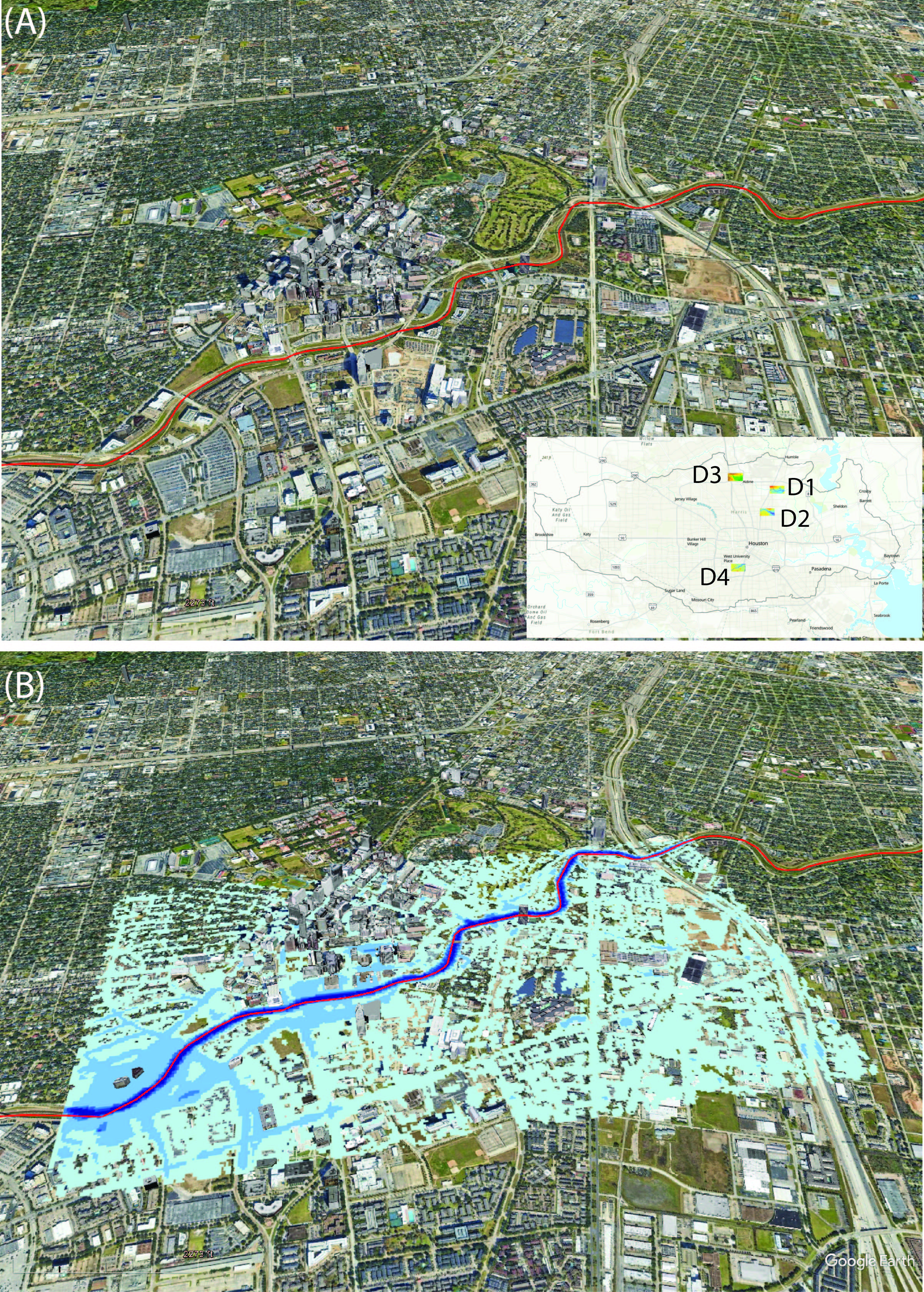
Physics model setup and dataset creation The efficacy of FNO was demonstrated via a series of experiments. Under the single-domain, multi-event setting, we considered a domain located in the Brays Bayou watershed near downtown Houston (D4 in Fig.1A). Brays Bayou is a fully urbanized watershed. Land use comprises of residential, industrial, and commercial buildings. The bayou flows eastward to its confluence with the Houston Ship Channel. Multiple historical storm events were simulated using the open-source CREST-iMAP, a coupled hydrology-hydraulic framework for riverbank flow and overland flood inundation modeling [20]. Previously, CREST-iMAP has been validated against Hurricane Harvey observations (e.g., streamflows, high water marks, and flood insurance claims) and showed comparable or better performance than other state-of-the-art hydrodynamic models [20]. In this study, CREST-iMAP was forced by using a high quality, radar-based quantitative precipitation estimation (QPE) product—the Multi-Radar/Multi-Sensor System (MRMS) data published by the National Severe Storms Laboratory (NSSL) in U.S. National Oceanic and Atmospheric Administration (NOAA). MRMS comes at 1-km resolution in 2-min intervals. It is behind several rainfall nowcasting DL models such as Google’s MetNet models [11, 33]. In Fig.1B, a typical flooding scene is shown. We used simulations corresponding to six storm events from NOAA storm inventory for training and the rest for testing (TableA1. Under the multi-domain, multi-event setting, the same NOAA storm events were first simulated over different spatial domains (D1–D3 in Fig.1A). We then trained an FNO model using D1–D3 data and tested on D4. More details on CREST-iMAP run configurations are provided under Appendix A1.
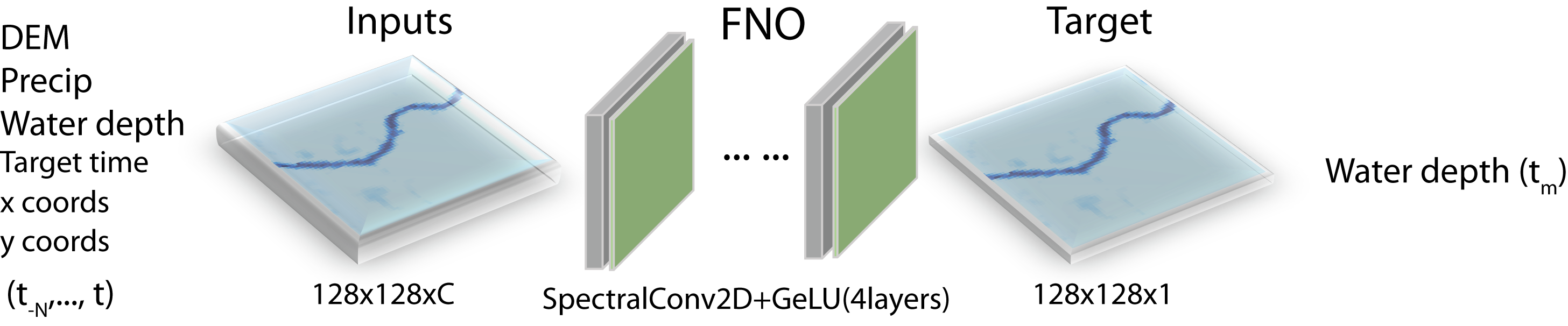
Surrogate model training A hybrid FNO surrogate model was trained for multi-step flood inundation prediction. We assumed the process-based flood inundation model and the FNO are running in parallel such that the outputs of the process-based model are available for the FNO model to ingest as predictors [34, 31]. To generate training datasets, we aggregated the CREST-iMAP inputs/outputs to 15-min intervals, and then sampled input and output patches from the spatial domain. Each 15-min frame was sampled twice by randomly varying image centers within the image bound. Fig.2 illustrates the architecture of the model. Inputs to FNO include antecedent precipitation and simulated water depths, and digital elevation model (DEM). A key feature of FNO is it concatenates x- and y-coordinates to the input features to help it capture dependencies between inputs and spatial locations, enabling the model to generalize to new locations [21]. The target variable is predicted water depth at a lead time, for which the target lead time value is concatenated to the inputs as a label. Alternatively, the target lead time can be treated as a trainable feature so that the trained model works for arbitrary lead times. The strategy was not used in this preliminary work. The FNO architecture includes four 2D spectral convolution layers, each followed by a GeLU activation layer. The data samples are split into training, validation, and testing in 0.8, 0.1, 0.1 ratios. The number of Fourier modes used is 16 in both directions.
We trained the models in PyTorch Lightning [12] using the Adam optimizer with an initial learning rate of 5e-4, a cosine annealing training schedule [22], and early stopping. Unless otherwise specified, the maximum epochs used is 60 and batch size is 8, which were found sufficient for this problem. Training was done on an Nvidia RTX3090 GPU. Training time per epoch is 72 sec wallclock time and inference time is 0.002 sec/sample. For baseline, we considered a U-Net like model adapted from RainNet, which has a relatively simple deep architecture but nonetheless performs surprisingly well on radar-based precipitation nowcasting problems [2]. RainNet still has 31.4M trainable parameters, while FNO has 8.1M. More details on the baseline model can be found in A2.
Performance metrics Model performance is measured using Critical Success Index (CSI, range 0–1.0) and mean absolute error (MAE, range 0–) that are often used in FIM [33, 26]. CSI is defined as , where #Hits is the number of flood events correctly predicted; #Misses is the number of flood events incorrectly predicted as non-flood events; and #FalseAlarms is the number of non-flood events incorrectly predicted as flood events [8]. In this work, we used the average of CSI calculated over three depth thresholds, 3cm, 10cm, and 25cm, to gauge model performance. In the literature 3cm is often used as the threshold for nuance flooding [24]. Both CSI and MAE were calculated at the grid cell level and then averaged spatially and temporally.
5 Results
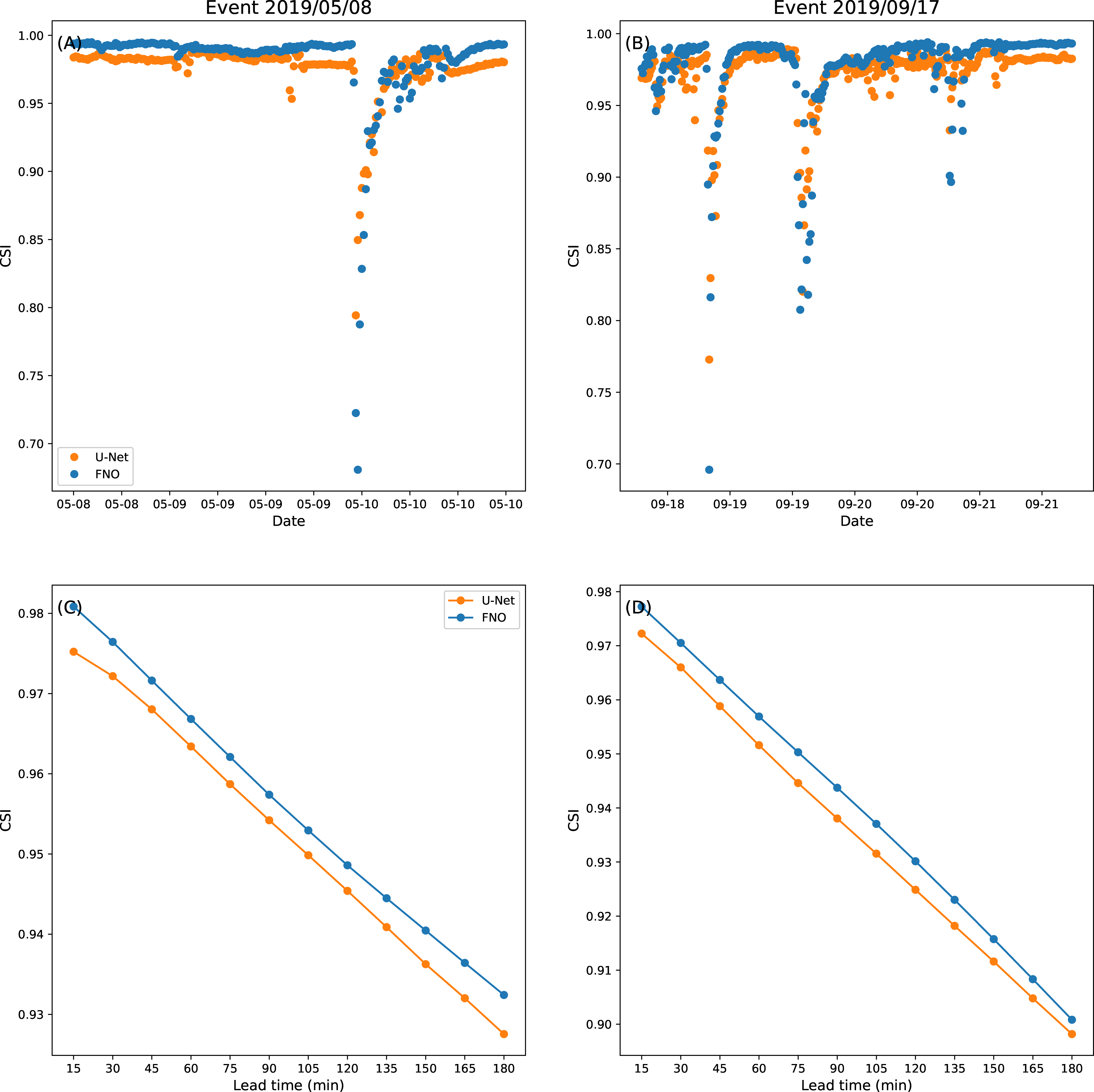
Single-domain multi-event results Table1 summarizes CSI and MAE metrics on two holdout storm events. Note the event on 2019/09/17 corresponds to Tropical Storm Imelda, which is the fourth wettest event on record in Texas [32]. At 12 lookback frames (i.e., 180min), FNO-12 outperformed U-Net-12 for all 12 lead times (Fig.3). The CSI of both models drops at the beginning of streamflow ascending due to strong discontinuity in predictors, but quickly bounces back for the rest of flood duration. As lead time increases, the FNO performance decreases linearly; thus, it is expected to give reasonable performance for longer lead times than tested here.
As ablation studies, we considered longer lookback periods (24 past frames or 6 hrs), which did not improve the results (FNO-24 in Table1). This is probably because of the lack of long memory during storm events. We also considered a precipitation-only experiment (FNO-12P in Table1) where no antecedent water depth information is used. In that case the CSI dropped significantly, suggesting the importance of hybrid forecasting.
Multi-domain multi-event results An FNO model pretrained using data from D1–D3 was applied to predict the same events and results for D4. Results, shown in Table 1 under FNO-MD, suggest the pretrained model adapts to the new domain well in this case, largely because of the physics embedded.
| Event | Model | 15min | 180min |
|---|---|---|---|
| (CSI, MAE) | (CSI, MAE) | ||
| 2019/05/08 | U-Net-12 | 0.9752, 0.0056 | 0.9275, 0.0168 |
| FNO-12 | 0.9808, 0.0044 | 0.9324, 0.0153 | |
| FNO-24 | 0.9764, 0.0048 | 0.9240, 0.0193 | |
| FNO-12P | 0.4861, 0.0825 | 0.4855, 0.0822 | |
| FNO-MD | 0.9659, 0.0083 | 0.9032, 0.0218 | |
| 2019/09/17 | U-Net-12 | 0.9723, 0.0088 | 0.8982, 0.0320 |
| FNO-12 | 0.9773, 0.0075 | 0.9008, 0.0286 | |
| FNO-24 | 0.9683, 0.0099 | 0.8914, 0.0348 | |
| FNO-12P | 0.4550, 0.1197 | 0.4470, 0.1187 | |
| FNO-MD | 0.9646, 0.0139 | 0.8895,0.0400 |
6 Conclusion
We have developed a Fourier Neural Operator (FNO) model for multi lead time rapid flood inundation modeling (FIM) by combining process-based modeling with data-driven ML. Results indicate the hybrid FNO learns the input/output mappings of the underlying hydrodynamic model well. The model may be deployed in parallel with the process-based modeling for rapid FIM.
Acknowledgement
AYS, WL, BRS, and CW were funded by Department of Energy Advanced Scientific Computing Research program under grant no. DE-SC0022211.
References
- [1] Jeroen CJH Aerts, WJ Wouter Botzen, Kerry Emanuel, Ning Lin, Hans De Moel, and Erwann O Michel-Kerjan. Evaluating flood resilience strategies for coastal megacities. Science, 344(6183):473–475, 2014.
- [2] Georgy Ayzel, Tobias Scheffer, and Maik Heistermann. Rainnet v1. 0: a convolutional neural network for radar-based precipitation nowcasting. Geoscientific Model Development, 13(6):2631–2644, 2020.
- [3] Paul Bates. Uneven burden of urban flooding. Nature Sustainability, 6(1):9–10, 2023.
- [4] Paul D Bates. Flood inundation prediction. Annual Review of Fluid Mechanics, 54:287–315, 2022.
- [5] Paul D Bates, Niall Quinn, Christopher Sampson, Andrew Smith, Oliver Wing, Jeison Sosa, James Savage, Gaia Olcese, Jeff Neal, Guy Schumann, et al. Combined modeling of us fluvial, pluvial, and coastal flood hazard under current and future climates. Water Resources Research, 57(2):e2020WR028673, 2021.
- [6] Peter Bauer, Peter D Dueben, Torsten Hoefler, Tiago Quintino, Thomas C Schulthess, and Nils P Wedi. The digital revolution of earth-system science. Nature Computational Science, 1(2):104–113, 2021.
- [7] Roberto Bentivoglio, Elvin Isufi, Sebastian Nicolaas Jonkman, and Riccardo Taormina. Deep learning methods for flood mapping: a review of existing applications and future research directions. Hydrology and Earth System Sciences, 26(16):4345–4378, 2022.
- [8] Robert A Clark, Jonathan J Gourley, Zachary L Flamig, Yang Hong, and Edward Clark. Conus-wide evaluation of national weather service flash flood guidance products. Weather and Forecasting, 29(2):377–392, 2014.
- [9] Salvatore Cuomo, Vincenzo Schiano Di Cola, Fabio Giampaolo, Gianluigi Rozza, Maziar Raissi, and Francesco Piccialli. Scientific machine learning through physics–informed neural networks: where we are and what’s next. Journal of Scientific Computing, 92(3):88, 2022.
- [10] Cesar AF do Lago, Marcio H Giacomoni, Roberto Bentivoglio, Riccardo Taormina, Marcus N Gomes Junior, and Eduardo M Mendiondo. Generalizing rapid flood predictions to unseen urban catchments with conditional generative adversarial networks. Journal of Hydrology, 618:129276, 2023.
- [11] Lasse Espeholt, Shreya Agrawal, Casper Sønderby, Manoj Kumar, Jonathan Heek, Carla Bromberg, Cenk Gazen, Rob Carver, Marcin Andrychowicz, Jason Hickey, et al. Deep learning for twelve hour precipitation forecasts. Nature communications, 13(1):5145, 2022.
- [12] William A Falcon. Pytorch lightning. GitHub, 3, 2019.
- [13] Zifeng Guo, Joao P Leitao, Nuno E Simões, and Vahid Moosavi. Data-driven flood emulation: Speeding up urban flood predictions by deep convolutional neural networks. Journal of Flood Risk Management, 14(1):e12684, 2021.
- [14] Yukiko Hirabayashi, Roobavannan Mahendran, Sujan Koirala, Lisako Konoshima, Dai Yamazaki, Satoshi Watanabe, Hyungjun Kim, and Shinjiro Kanae. Global flood risk under climate change. Nature climate change, 3(9):816–821, 2013.
- [15] Julian Hofmann and Holger Schüttrumpf. floodgan: Using deep adversarial learning to predict pluvial flooding in real time. Water, 13(16):2255, 2021.
- [16] George Em Karniadakis, Ioannis G Kevrekidis, Lu Lu, Paris Perdikaris, Sifan Wang, and Liu Yang. Physics-informed machine learning. Nature Reviews Physics, 3(6):422–440, 2021.
- [17] Karthik Kashinath, M Mustafa, Adrian Albert, JL Wu, C Jiang, Soheil Esmaeilzadeh, Kamyar Azizzadenesheli, R Wang, A Chattopadhyay, A Singh, et al. Physics-informed machine learning: case studies for weather and climate modelling. Philosophical Transactions of the Royal Society A, 379(2194):20200093, 2021.
- [18] Goutam Konapala, Sujay V Kumar, and Shahryar Khalique Ahmad. Exploring sentinel-1 and sentinel-2 diversity for flood inundation mapping using deep learning. ISPRS Journal of Photogrammetry and Remote Sensing, 180:163–173, 2021.
- [19] Nikola Kovachki, Zongyi Li, Burigede Liu, Kamyar Azizzadenesheli, Kaushik Bhattacharya, Andrew Stuart, and Anima Anandkumar. Neural operator: Learning maps between function spaces. arXiv preprint arXiv:2108.08481, 2021.
- [20] Zhi Li, Mengye Chen, Shang Gao, Xiangyu Luo, Jonathan J Gourley, Pierre Kirstetter, Tiantian Yang, Randall Kolar, Amy McGovern, Yixin Wen, et al. Crest-imap v1. 0: A fully coupled hydrologic-hydraulic modeling framework dedicated to flood inundation mapping and prediction. Environmental Modelling & Software, 141:105051, 2021.
- [21] Zongyi Li, Nikola Kovachki, Kamyar Azizzadenesheli, Burigede Liu, Kaushik Bhattacharya, Andrew Stuart, and Anima Anandkumar. Fourier neural operator for parametric partial differential equations. arXiv preprint arXiv:2010.08895, 2020.
- [22] Ilya Loshchilov and Frank Hutter. Sgdr: Stochastic gradient descent with warm restarts. arXiv preprint arXiv:1608.03983, 2016.
- [23] Bruno Merz, Günter Blöschl, Sergiy Vorogushyn, Francesco Dottori, Jeroen CJH Aerts, Paul Bates, Miriam Bertola, Matthias Kemter, Heidi Kreibich, Upmanu Lall, et al. Causes, impacts and patterns of disastrous river floods. Nature Reviews Earth & Environment, 2(9):592–609, 2021.
- [24] Hamed R Moftakhari, Amir AghaKouchak, Brett F Sanders, Maura Allaire, and Richard A Matthew. What is nuisance flooding? defining and monitoring an emerging challenge. Water Resources Research, 54(7):4218–4227, 2018.
- [25] Bo Peng, Zonglin Meng, Qunying Huang, and Caixia Wang. Patch similarity convolutional neural network for urban flood extent mapping using bi-temporal satellite multispectral imagery. Remote Sensing, 11(21):2492, 2019.
- [26] Matthew Preisser, Paola Passalacqua, R Patrick Bixler, and Julian Hofmann. Intersecting near-real time fluvial and pluvial inundation¡? xmltexbreak?¿ estimates with sociodemographic vulnerability¡? xmltexbreak?¿ to quantify a household flood impact index. Hydrology and Earth System Sciences, 26(15):3941–3964, 2022.
- [27] Maziar Raissi, Paris Perdikaris, and George E Karniadakis. Physics-informed neural networks: A deep learning framework for solving forward and inverse problems involving nonlinear partial differential equations. Journal of Computational physics, 378:686–707, 2019.
- [28] Brett F Sanders, Jochen E Schubert, Daniel T Kahl, Katharine J Mach, David Brady, Amir AghaKouchak, Fonna Forman, Richard A Matthew, Nicola Ulibarri, and Steven J Davis. Large and inequitable flood risks in los angeles, california. Nature sustainability, 6(1):47–57, 2023.
- [29] Omar Seleem, Georgy Ayzel, Axel Bronstert, and Maik Heistermann. Transferability of data-driven models to predict urban pluvial flood water depth in berlin, germany. Natural Hazards and Earth System Sciences, 23(2):809–822, 2023.
- [30] Xinyi Shen, Dacheng Wang, Kebiao Mao, Emmanouil Anagnostou, and Yang Hong. Inundation extent mapping by synthetic aperture radar: A review. Remote Sensing, 11(7):879, 2019.
- [31] Louise J Slater, Louise Arnal, Marie-Amélie Boucher, Annie Y-Y Chang, Simon Moulds, Conor Murphy, Grey Nearing, Guy Shalev, Chaopeng Shen, Linda Speight, et al. Hybrid forecasting: blending climate predictions with ai models. Hydrology and earth system sciences, 27(9):1865–1889, 2023.
- [32] Adam Smith. 2010–2019: A landmark decade of us. billion-dollar weather and climate disasters. National Oceanic and Atmospheric Administration, 2020.
- [33] Casper Kaae Sønderby, Lasse Espeholt, Jonathan Heek, Mostafa Dehghani, Avital Oliver, Tim Salimans, Shreya Agrawal, Jason Hickey, and Nal Kalchbrenner. Metnet: A neural weather model for precipitation forecasting. arXiv preprint arXiv:2003.12140, 2020.
- [34] Alexander Y Sun, Peishi Jiang, Zong-Liang Yang, Yangxinyu Xie, and Xingyuan Chen. A graph neural network (gnn) approach to basin-scale river network learning: the role of physics-based connectivity and data fusion. Hydrology and Earth System Sciences, 26(19):5163–5184, 2022.
- [35] WV Sweet et al. 2022 sea level rise technical report. 2022.
- [36] Gege Wen, Zongyi Li, Kamyar Azizzadenesheli, Anima Anandkumar, and Sally M Benson. U-fno—an enhanced fourier neural operator-based deep-learning model for multiphase flow. Advances in Water Resources, 163:104180, 2022.
- [37] Oliver EJ Wing, William Lehman, Paul D Bates, Christopher C Sampson, Niall Quinn, Andrew M Smith, Jeffrey C Neal, Jeremy R Porter, and Carolyn Kousky. Inequitable patterns of us flood risk in the anthropocene. Nature Climate Change, 12(2):156–162, 2022.
- [38] Faria T Zahura, Jonathan L Goodall, Jeffrey M Sadler, Yawen Shen, Mohamed M Morsy, and Madhur Behl. Training machine learning surrogate models from a high-fidelity physics-based model: Application for real-time street-scale flood prediction in an urban coastal community. Water Resources Research, 56(10):e2019WR027038, 2020.
- [39] Jakob Zscheischler, Seth Westra, Bart JJM Van Den Hurk, Sonia I Seneviratne, Philip J Ward, Andy Pitman, Amir AghaKouchak, David N Bresch, Michael Leonard, Thomas Wahl, et al. Future climate risk from compound events. Nature Climate Change, 8(6):469–477, 2018.
Appendix
A1 Model configuration
Storm events were retrieved from U.S. National Oceanic and Atmospheric Administration (NOAA) catalog. Table A1 shows the start and end dates of all storm events. The events are further visualized on the streamflow hydrograph in Fig. A1.
Resolution of the digital elevation model (DEM) used in this study is 10m, which is obtained from U.S. Geological Survey (USGS) https://www.usgs.gov/3d-elevation-program/about-3dep-products-services. Streamflow (USGS Gage 08075000) is used as upper boundary condition for hydrodynamic model CREST-iMAP (Fig. A1. We used a radar-based precipitation forcing dataset, the MRMS data from NOAA https://mrms.nssl.noaa.gov. MRMS comes at spatial resolution of 4 km and 2-min temporal resolution.
CREST-iMAP uses hydrological CREST to solve for water balance equation and ANUGA-Hydro for hydrulic modeling [20].
| Start Date | End Date | Usage |
|---|---|---|
| 2017/06/04 | 2017/06/07 | Training/validation |
| 2017/06/24 | 2017/06/26 | Training/validation |
| 2017/07/09 | 2017/07/13 | Training/validation |
| 2017/08/26 | 2017/09/02 | Training/validation |
| 2018/07/04 | 2018/07/07 | Training/validation |
| 2018/12/07 | 2018/12/10 | Training/validation |
| 2019/05/07 | 2019/05/11 | Testing |
| 2019/09/19 | 2019/09/22 | Testing |


A2 U-Net model architecture
The U-Net architecture is based on the PyTorch implementation of RainNet [2], https://github.com/fmidev/rainnet.
| Layer | Feature In | Feature Out | kernel size |
|---|---|---|---|
| Input | C | 64 | 3 |
| D1 | 64 | 128 | 3 |
| Maxpool | 2 | ||
| D2 | 128 | 256 | 3 |
| Maxpool | 2 | ||
| D3 | 256 | 512 | 3 |
| Maxpool | 2 | ||
| D4 | 512 | 1024 | 3 |
| Maxpool | 2 | ||
| U1 | 1536 | 512 | 3 |
| Upsample | 2 | ||
| U2 | 768 | 256 | 3 |
| Upsample | 2 | ||
| U3 | 384 | 128 | 3 |
| Upsample | 2 | ||
| U4 | 192 | 64 | 3 |
| Upsample | 2 | ||
| Last | 64 | 2 | 3 |
| Output | 2 | 1 | 1 |
The RainNet model was trained using the log hyperbolic cosine loss function (), which has been shown to be beneficial to precipitation nowcasting ML applications [2]
| (5) |
where , and are ”true” and predicted water depths.