The mapKurator System: A Complete Pipeline for Extracting and Linking Text from Historical Maps (Demo Paper)
Abstract.
Scanned historical maps in libraries and archives are valuable repositories of geographic data that often do not exist elsewhere. Despite the potential of machine learning tools like the Google Vision APIs for automatically transcribing text from these maps into machine-readable formats, they do not work well with large-sized images (e.g., high-resolution scanned documents), cannot infer the relation between the recognized text and other datasets, and are challenging to integrate with post-processing tools. This paper introduces the mapKurator system, an end-to-end system integrating machine learning models with a comprehensive data processing pipeline. mapKurator empowers automated extraction, post-processing, and linkage of text labels from large numbers of large-dimension historical map scans. The output data, comprising bounding polygons and recognized text, is in the standard GeoJSON format, making it easily modifiable within Geographic Information Systems (GIS). The proposed system allows users to quickly generate valuable data from large numbers of historical maps for in-depth analysis of the map content and, in turn, encourages map findability, accessibility, interoperability, and reusability (FAIR principles). We deployed the mapKurator system and enabled the processing of over 60,000 maps and over 100 million text/place names in the David Rumsey Historical Map collection. We also demonstrated a seamless integration of mapKurator with a collaborative web platform to enable accessing automated approaches for extracting and linking text labels from historical map scans and collective work to improve the results.
1. Introduction

Historical maps constitute an extensive body of geographic information providing a detailed understanding of changes over time (Rumsey and Williams, 2002). Many historical maps are publicly available from online map archives and digital libraries (Chiang et al., 2020). One of the largest collections of scanned historical maps is the David Rumsey Map Collection, which has more than 115,000 scanned maps from the 16th through the 21st century. 111https://www.davidrumsey.com/ To enable advanced search queries allowing users to retrieve relevant historical maps, data curators of various backgrounds, including geographers, historians, and librarians, have put substantial efforts into generating comprehensive metadata for individual map scans using map content and additional data sources. However, creating and maintaining metadata of scanned maps requires expert knowledge and extensive manual work (Rumsey and Williams, 2002).
There have been many attempts to convert text labels on maps to analytic-ready data, including crowdsourced projects (e.g., GB1900 222https://geo.nls.uk/maps/gb1900/) and machine learning model-based approaches (Li et al., 2020; Weinman et al., 2019; Li et al., 2018). Although prior studies have actively investigated automatic approaches, they focus on developing machine learning models for text detection and recognition with limited emphasis on the end-to-end data pipeline from large numbers of map images to repositories of searchable text labels. Also, the automated results can still be imperfect, leading to inaccurate map metadata, discouraging the user community, and creating a gap between end-users and technologies. For example, a user using the Google Vision API or a text spotting model will need to take care of large input image dimensions, write specialized code for handling geocoordinates and format conversion, and often require to conduct ad-hoc post-processing to improve the automated results. These steps require particular technology skills (e.g., writing Python scripts for data join and format conversion) and IT (information technology) resources, which might not be available for a wide variety of users and institutes. This human-computer gap limits the broader impact of the automatic map processing approaches and hinders historical maps’ findability, accessibility, interoperability, and reusability (FAIR principles (Wilkinson et al., 2016)).
To bridge the gap between end-users and intelligent technologies and promote the FAIR principles of historical maps, we present the mapKurator system that allows users to leverage ready-to-use automatic map processing technologies for processing large numbers of large-dimension historical map scans to convert their text content into a standard, machine-readable format. mapKurator’s overall system capabilities include automatic processes of 1) detecting and recognizing text from map scans of large dimensions, 2) automatic post-processing and linking text labels to their corresponding entities in external knowledge bases, and 3) recommending semantic types of user’s input. Target users of the proposed system include historians, geographers, librarians, and other researchers who study full-textual content on historical maps or use the text label to generate map metadata (e.g., geographical things described in the text label, their locations, and their semantics and other attributes).
We have built and publicly released Docker images of the mapKurator system333https://knowledge-computing.github.io/mapkurator-doc/ and the integration of the mapKurator system with a collaborative web-based annotation platform (Recogito).444https://recogito.pelagios.org/ The deployment of the mapKurator system at the University of Minnesota has processed over 60,000 maps and over 100 million text/place names in the David Rumsey Historical Map collection. These 100 million text labels have been incorporated into the metadata platform to support a full-text search of map content by Luna Imaging.555https://mailchi.mp/stanford/apr2023-ai-advancements-in-map-studies The mapKurator system has also processed thousands of Sanborn Fire Insurance maps from the Library of Congress and historical Ordinance Survey maps from the National Library of Scotland. We are in the process of releasing the processing results as open research data.
The following sections describe the workflow of the mapKurator system and its architecture, related work on annotation interfaces and text spotters, and a discussion on future work.
2. The mapKurator System
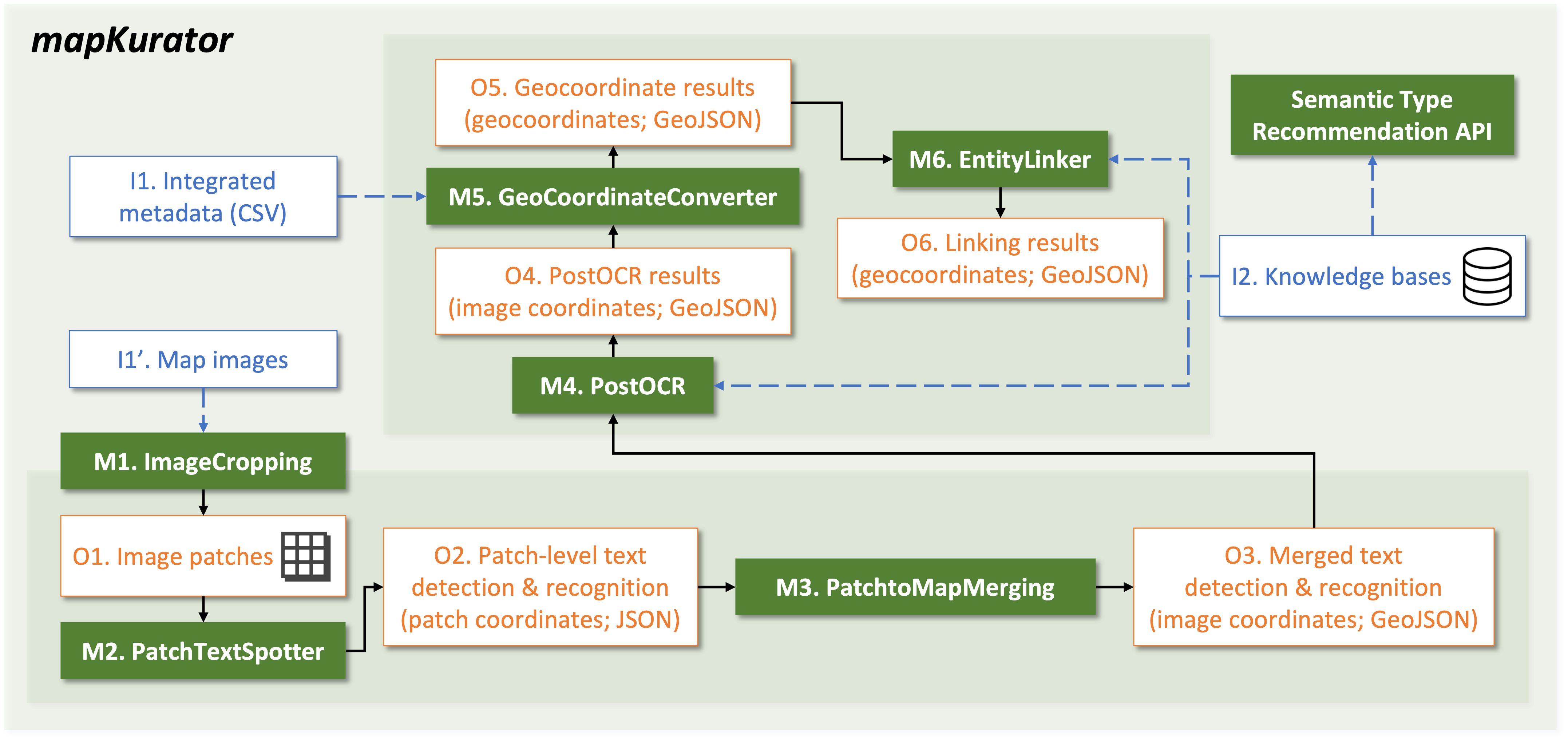
Figure 1 shows the proposed mapKurator system. The data pipeline is as follows. mapKurator takes a map image as input, slices the image into small patches (M1), detects and recognizes text labels on each patch (M2), combines the predicted text labels from all patches (M3), performs automatic post-processing (M4)(Namgung and Chiang, 2022), converts their image coordinates to geocoordinates (M5), and links to the entities in external knowledge bases (M6). The final output is in the GeoJSON format, which can be viewed and edited across various geographic information systems (e.g., QGIS). The user can also collaboratively modify mapKurator results on the Recogito web interface using the integrated mapKurator and Recogito. The details of each module and GeoJSON format are as follows.
M1. ImageCropping High-resolution historical map images typically contain a large amount of detail, which can result in very large file sizes. This poses a challenge when working with the images due to the large memory requirement. To overcome this challenge, the system crops the map images into smaller tiles, where each tile contains a sub-region (e.g., 1000 1000 pixels) of the input.
M2. PatchTextSpotter mapKurator utilizes a text-spotting model to detect and recognize text on the image patches. Our model builds upon Deformable DETR (Zhu et al., 2020) and TESTR (Zhang et al., 2022), in which the encoder processes the image features and generates text proposals (i.e., coarse bounding boxes), while the decoder refines the proposals to obtain arbitrary-shaped detection results and extracts text within the proposals. To train the text spotter effectively, we employ synthetic datasets, including a synthetic scene image dataset (Gupta et al., 2016), a novel synthetic map dataset designed to mimic text placement on historical maps, inspired by (Li et al., 2021), along with real-world images with human annotations. The output of this module includes the detected text regions, comprising 16 boundary points with image patch coordinates and the corresponding recognized text.
M3. PatchtoMapMerging After performing text spotting on each tile independently in parallel, mapKurator merges the results from each tile by collecting all the patch-level predictions and shifting the predicted image coordinates according to the patch location.
M4. PostOCR To improve the output of text spotting results, mapKurator runs lexical-based post-OCR processing by using the edit distance to compare the text spotting results and a vocabulary set. mapKurator generates the vocabulary set from geo-entities in OpenStreetMap and breaks ties using the geo-entity’s popularity (i.e., frequency).
M5. GeocoordinateConverter mapKurator takes the map metadata, which includes ground control point pairs and transformation methods (e.g., the affine transformation) to convert the predicted bounding polygons (i.e., spotting results) from image coordinates to geocoordinates by using translator library, GDAL666https://gdal.org/index.html.
M6. EntityLinker After the coordinate transformation, mapKurator links the post-processed text label to the corresponding geo-entities in external knowledge bases (e.g., OpenStreetMap, Wikidata) or historical gazetteers. The identified linkages enable advanced search queries on scanned maps by leveraging geo-entity properties in knowledge bases (Li et al., 2020). In the current version of the mapKurator system, EntityLinker retrieves the candidate geo-entities in OpenStreetMap that satisfy two criteria: 1) the suggested word (i.e., output from M4) is a substring of the candidate geo-entity’s name and 2) the geocoordinates of text bounding polygon (i.e., output from M5) is in the geometry of OpenStreetMap geo-entities.

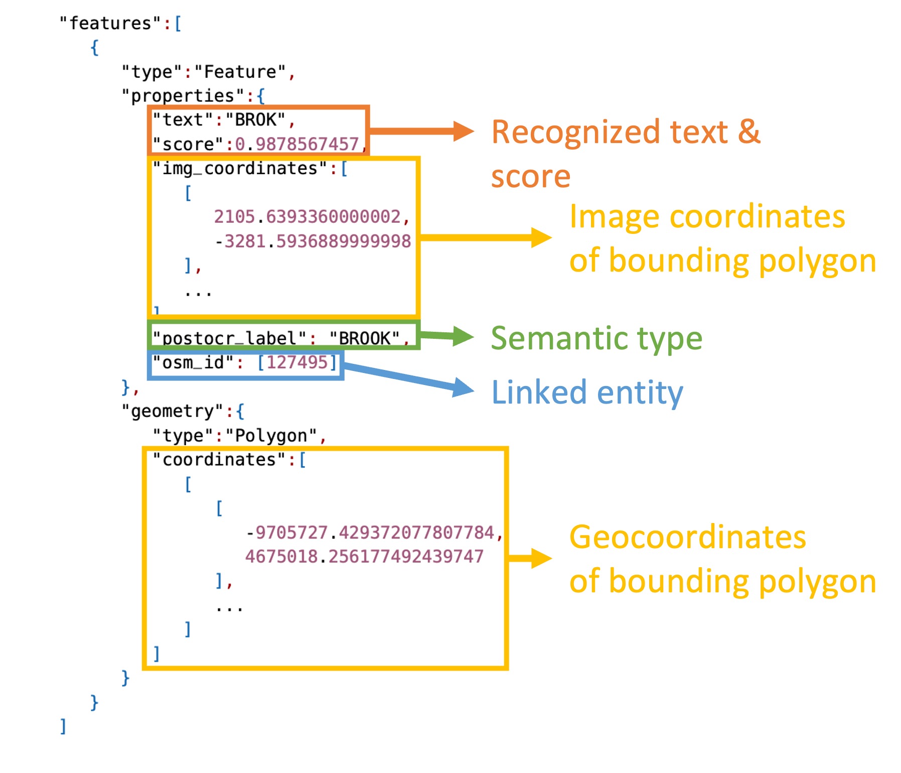
Figure 2 shows an example GeoJSON result that refers to one of the processed text via mapKurator. Each GeoJSON feature contains the geocoordinates of the bounding polygon (the ‘coordinates’ field in Figure 2) and several properties, including the predicted text label with score (‘text’ & ‘score’ field), post-processed text label (‘postocr_label’ field), and the unique identifiers of matched entities in the external knowledge bases. The post-processed text ‘BROOK’ has the linked entity from OpenStreetMap (‘osm_id’ field). The system can also match the text label in other external knowledge bases or historical gazetteers.
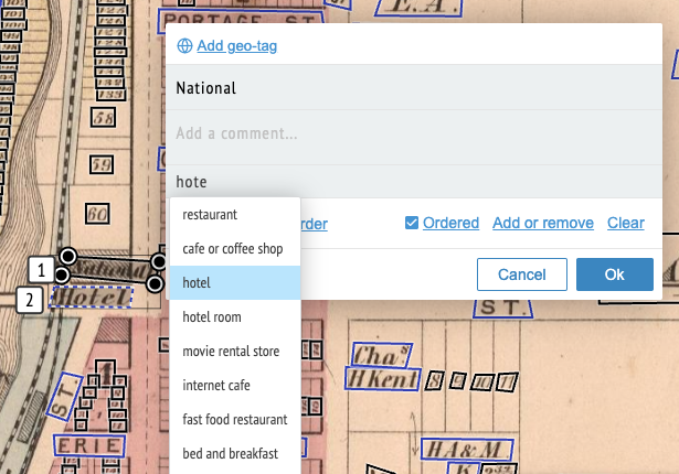
To demonstrate mapKurator’s results and facilitate interoperability and findability of the text on maps, the mapKurator system also provides a semantic type recommendation application programming interface (API),777https://github.com/machines-reading-maps/semantic-type-recommendation-api for semi-automatic type selection in the integrated mapKurator and Recogito. Traditional approaches for finding the relevant semantic type for a text on the map from a large set of vocabulary are based on expert efforts and are time-consuming. The API employs a fastText model pretrained on large corpora of Wikipedia (Bojanowski et al., 2016) with 240 standardized semantic types from Schema.org 888https://schema.org to retrieve semantically semantic types in real-time while typing (Figure 3).


In summary, the mapKurator system provides ready-to-use intelligent technologies, allowing users to extract and link text on maps. The system also promotes the four fundamental FAIR principles for historical maps. The results enable advanced search queries for finding relevant historical maps. Figure 4 shows examples of mapKurator’s results from Luna Imaging.
3. Related Work
Extracting text from scanned images rely on manual annotations or text-spotting tools. One of the most common image labeling software tools called LabelMe (Russell et al., 2008) has discussed the potential semi-automatic approaches to leveraging image processing algorithms and online image search engines to assist manual labeling of images. The user of LabelMe can validate a predicted bounding box and edit the label by removing or redrawing the bounding box. Another interactive annotation tool, iVAT (Bianco et al., 2015), is designed for video annotation and supports three different annotation approaches, manual, semi-automatic, and automatic. Regarding semi-automatic annotation, iVAT requires users to annotate an initial set of given video frames and applies automatic algorithms to provide the remaining annotations. However, the aforementioned systems mainly focus on generating annotated data for training machine learning models and do not consider these annotated data as spatial things (e.g., see cartographic interaction (Roth, 2012)), such as text on maps. In contrast, Recogito allows users to collaboratively annotate text bounding boxes in diverse shapes and transcribe the text but still, the process is time-consuming and does not scale to process large numbers of maps. State-of-the-art text spotting models, such as TESTR (Zhang et al., 2022) and SwinTextSpotter (Huang et al., 2022), detects a bounding polygon and recognizes the text for each text instance in end-to-end trainable approach. Existing text spotters typically focus on scene images such as advertisements and rescale an input image into a small, fixed-size image, which cannot be directly applied to historical maps. Improving text spotters to address complex historical maps with a variety of cartographic styles requires lots of programming skills and additional steps to exploit map geocoordinates for refining the results.
To process a large number of historical maps and provide an easily transferable standardized output, mapKurator system proposes a complete end-to-end data pipeline with well-defined modules. The system makes it easy for users to utilize the latest development in text spotter for extracting text on maps. Also, the integration of the mapKurator system and Recogito enables ready-to-use intelligent technologies with a collaborative annotation web interface, allowing the generation of complete text content or metadata of historical maps for users of all levels of technical skills.
4. Discussion and Future Work
We presented a complete map processing system, mapKurator, that consists of ready-to-use intelligent technologies and the integration of the map processing system with a collaborative web-based annotation platform. mapKurator fills the gap between users and automatic approaches and promotes the fundamental four FAIR principles for historical maps and their content. We plan to incorporate the capability in mapKurator to process maps with multiple languages. We also plan to build interactive machine-learning approaches, exploiting users’ annotations to actively improve the results. Moreover, we will support various ontologies and file formats to address the demands of wide user communities.
Acknowledgements.
This material is based upon work supported in part by NVIDIA Corporation, the gift from David and Abby Rumsey to the University of Minnesota Foundation, and the University of Minnesota, Computer Science & Engineering Faculty startup funds. We thank Tanisha Shrotriya and Rainer Simon for their efforts in the integration of the mapKurator system and Recogito. We especially thank David Rumsey for his generous support and encouragement.References
- (1)
- Bianco et al. (2015) Simone Bianco, Gianluigi Ciocca, Paolo Napoletano, and Raimondo Schettini. 2015. An interactive tool for manual, semi-automatic and automatic video annotation. Computer Vision and Image Understanding 131 (2015), 88–99.
- Bojanowski et al. (2016) Piotr Bojanowski, Edouard Grave, Armand Joulin, and Tomas Mikolov. 2016. Enriching Word Vectors with Subword Information. arXiv preprint arXiv:1607.04606 (2016).
- Chiang et al. (2020) Yao-Yi Chiang, Weiwei Duan, Stefan Leyk, Johannes H Uhl, and Craig A Knoblock. 2020. Using historical maps in scientific studies: Applications, challenges, and best practices. Springer.
- Gupta et al. (2016) Ankush Gupta, Andrea Vedaldi, and Andrew Zisserman. 2016. Synthetic data for text localisation in natural images. In Proceedings of the IEEE conference on computer vision and pattern recognition. 2315–2324.
- Huang et al. (2022) Mingxin Huang, Yuliang Liu, Zhenghao Peng, Chongyu Liu, Dahua Lin, Shenggao Zhu, Nicholas Yuan, Kai Ding, and Lianwen Jin. 2022. Swintextspotter: Scene text spotting via better synergy between text detection and text recognition. In Proc. of CVPR ’22. 4593–4603.
- Li et al. (2018) Huali Li, Jun Liu, and Xiran Zhou. 2018. Intelligent map reader: A framework for topographic map understanding with deep learning and gazetteer. IEEE Access 6 (2018), 25363–25376.
- Li et al. (2020) Zekun Li, Yao-Yi Chiang, Sasan Tavakkol, Basel Shbita, Johannes H Uhl, Stefan Leyk, and Craig A Knoblock. 2020. An Automatic Approach for Generating Rich, Linked Geo-Metadata from Historical Map Images. In Proc. of ACM SIGKDD ’20. 3290–3298.
- Li et al. (2021) Zekun Li, Runyu Guan, Qianmu Yu, Yao-Yi Chiang, and Craig A Knoblock. 2021. Synthetic Map Generation to Provide Unlimited Training Data for Historical Map Text Detection. In Proceedings of the 4th ACM SIGSPATIAL International Workshop on AI for Geographic Knowledge Discovery. 17–26.
- Namgung and Chiang (2022) Min Namgung and Yao-Yi Chiang. 2022. Incorporating Spatial Context for Post-OCR in Map Images. In Proc. of the 5th ACM SIGSPATIAL International Workshop on AI for Geographic Knowledge Discovery (GeoAI ’22). Association for Computing Machinery, New York, NY, USA, 14–17.
- Roth (2012) Robert E Roth. 2012. Cartographic interaction primitives: Framework and synthesis. The Cartographic Journal 49, 4 (2012), 376–395.
- Rumsey and Williams (2002) David Rumsey and Meredith Williams. 2002. Historical maps in GIS.
- Russell et al. (2008) Bryan C Russell, Antonio Torralba, Kevin P Murphy, and William T Freeman. 2008. LabelMe: a database and web-based tool for image annotation. International Journal of Computer Vision 77, 1 (2008), 157–173.
- Weinman et al. (2019) Jerod Weinman, Ziwen Chen, Ben Gafford, Nathan Gifford, Abyaya Lamsal, and Liam Niehus-Staab. 2019. Deep neural networks for text detection and recognition in historical maps. In Proc. of IEEE ICDAR ’19. IEEE, 902–909.
- Wilkinson et al. (2016) Mark D Wilkinson, Michel Dumontier, IJsbrand Jan Aalbersberg, Gabrielle Appleton, Myles Axton, Arie Baak, Niklas Blomberg, Jan-Willem Boiten, Luiz Bonino da Silva Santos, Philip E Bourne, et al. 2016. The FAIR Guiding Principles for scientific data management and stewardship. Scientific data 3, 1 (2016), 1–9.
- Zhang et al. (2022) Xiang Zhang, Yongwen Su, Subarna Tripathi, and Zhuowen Tu. 2022. Text spotting transformers. In Proc. of CVPR ’22. 9519–9528.
- Zhu et al. (2020) Xizhou Zhu, Weijie Su, Lewei Lu, Bin Li, Xiaogang Wang, and Jifeng Dai. 2020. Deformable detr: Deformable transformers for end-to-end object detection. arXiv preprint arXiv:2010.04159 (2020).