Measurement-based Channel Characterization for A2A and A2G Wireless Drone Communication Systems
Abstract
This paper presents field measurement-based channel characterization for air–to–ground (A2G) and air–to–air (A2A) wireless communication systems using two drones equipped with lightweight software-defined radios. A correlation-based channel sounder is employed such that the transmitting drone broadcasts the sounding waveform with a pseudo-noise sequence and the receiving drone captures the sounding waveform together with the location information for the post-processing analysis. The path loss results demonstrate that the measurement and flat-earth two-ray results have similar trends for A2G while the measurement and free space path loss are similar to each other for A2A. The time delays between the direct path and multipath components are widely spread for A2A while the multipath components are mostly concentrated around the direct path for A2G generating a more challenging communication environment. We observe that the reflections from several buildings having metal roofs and claddings on the measurement site cause sudden peaks in the root-mean-square delay spread. The results indicate that the A2A channel has better characteristics than the A2G under similar mobility conditions.
Index Terms:
A2A, A2G, channel sounder, drone communication, 5G, measurementsI Introduction
The usage of unmanned air vehicles or drones in the popular term has been growing rapidly for many applications such as cargo transportation, smart agriculture, surveillance, public safety, disaster management, science, and military [1, 2, 3]. A high data rate wireless communication is an essential component of these systems since typical applications require the transmission of high resolution images and videos from one drone to another or the ground station (GS). The integration of terrestrial and non-terrestrial systems including UAVs and satellites is a highly popular topic in 5G and beyond networks. It is an outmost important task to characterize a wideband wireless communication channel for Air–to–Ground (A2G) and Air–to–Air (A2A) operating at 5G carrier frequencies in order to design robust and reliable waveforms for these environments.
A comprehensive survey of the A2G channel models for UAVs have been provided in [4, 5], where the primary distinction of the UAV A2G channels is the addition of a third dimension as an altitude. The important parameters include the type of channel sounding signal, its center frequency, bandwidth, transmit power, UAV speed, heights of UAV and GS, link distance, elevation angle, and local GS environment characteristics. The measurement-based models for path loss exponents and shadowing for the radio channel between UAVs and live LTE networks operating at the carrier frequency of 800 MHz are studied in [6]. The authors identify that the height of UAV is an important parameter for characterizing the propagation channel for UAVs as the average number of detected cells increases as the UAV moves higher altitudes. In [7], the effects of a human body on the A2G channel model are studied through measurement experiments when the UAV is at low altitudes while there are three different use cases of holding a user equipment, namely, near-chest facing, in-pocket facing, and near-chest facing-away. In another recent study [8], the authors characterize A2G wireless channels for L-Band (1-2 GHz) and C-Band (4-8 GHz) using a commercially available drone equipped with software-defined radio (SDR). The drone is used to transmit wideband chirp waveforms whose bandwidths are 26 MHz and 48 MHz for L-band and C-band, respectively, while a commercial signal and spectrum analyzer on the ground is used as the receiver. Our work is similar to the above studies in terms of characterizing A2G wireless channels. However, our carrier frequency is 3.5 GHz, the bandwidth is 50 MHz, the drone altitude is 100 meters and we characterize not only A2G but also A2A wireless channels.
The number of measurement-based channel characterization studies for A2A wideband wireless communication channels [9, 10, 11, 12] is limited compared to the A2G studies. In [9], A2A channel measurements are conducted at 5.2 GHz with 100 MHz bandwidth in urban environments by utilizing analog optical links to transmit the channel sounding signal for characterizing the propagation effects, where the exact trajectories of the drones and the three-dimensional layout of the environment are utilized. As an extension study in [10], the authors apply the same measurement campaign for several flight paths in three different environments to find a relation between the multipath components and real-world objects. In [11], field experiments are carried out to measure the effects of the mobility uncertainties on mmWave/THz-band communications between flying drones. Then, the findings are utilized to perform the capacity analysis based on the simulations.
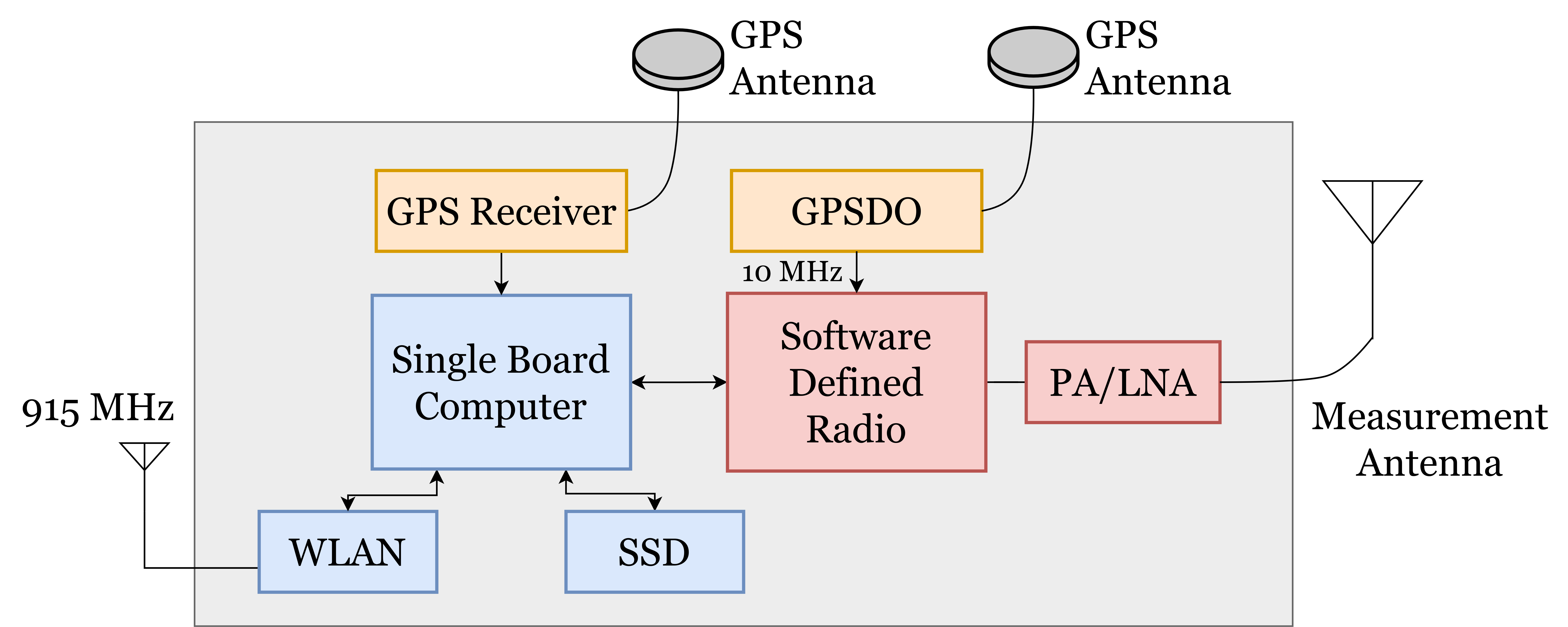
In this paper, field measurement-based channel characterization for A2G and A2A wireless communication systems is presented using two DJI Matrice 600 Pro drones equipped with lightweight SDRs. It is a challenging task to perform a measurement-based quantitative characterization of A2G and A2A wideband wireless communication channels since it requires generating and receiving high-speed data at the transceiver and storing a tremendous amount of data at the receiver. Since the weight of the payload which can be carried by a drone is limited, the SDR-based cost-effective and lightweight transceivers are employed for transmitting and receiving the radio signals over the air. A single board computer (SBC) with solid state drive (SSD) is used to generate and store high data rate baseband IQ samples. GPS disciplined oscillator (GPSDO) is utilized to ensure precise frequency synchronization between the transmitting and receiving SDRs. GPS receiver provides high-precision location measurements of both transmitting and receiving drones which are remotely controlled through WLAN interface operating at the carrier frequency of 915 MHz. This control interface is also used to manage the experiments by starting and stopping the measurements. In this study, we employ a correlation-based channel sounder such that the transmitting drone broadcasts the sounding waveform including a pseudo–noise (PN)–sequence with the length 4095 and the receiving drone captures the sounding waveform together with the location information for the post-processing analysis.
The path loss results of the measurement, fit line, free–space path loss (FSPL) and flat-earth two-ray (FE2R) models for the A2G and A2A scenarios demonstrate that the measurement and FE2R results have similar trends for A2G while the measurement and FSPL are similar to each other for A2G. The time delay between direct path and multipath components mostly lies between 0 and 300 ns for A2G while it is widely spread between 0 and 2 s for A2A. There are several buildings having metal roofs and claddings on the measurement site, where the reflections from these structures result in sudden peaks in the delay spread (RMS-DS). The results indicate that the A2A channel has better characteristics than the A2G under similar mobility conditions indicating that higher capacities can be achieved by the A2A scenario using the same bandwidth.
II Wireless Channel Model
In this paper, we characterize A2G and A2A wireless channels through field measurements, where the following model is used for both. A wireless propagation channel including multipath fading is defined as a time-variant system
| (1) |
where represents the number of channel taps while , , and are the amplitude, phase, and delay of the –th path, respectively. An important measure for a wireless channel is the power-delay profile (PDP), which characterizes the gains of the respective delays. An instantaneous PDP can be calculated as
| (2) |
where, represents the channel impulse response (CIR). Another important measure that we consider is the path loss model which characterizes the received power with respect to the distance between a transmitter and a receiver. It is expressed as
| (3) |
where is the distance between a transmitter and a receiver in meters, is the path loss exponent (PLE), is the reference distance for path loss measurements, is the FSPL, and contains remaining large–scale characteristic losses for line–of–sight (LOS).
Considering the wideband channel modeling, the RMS delay spread is useful to measure time dispersion or frequency selectivity. The RMS delay spread can be calculated using the second-order central moment of the PDP as
| (4) |
where is the RMS delay spread for an instantaneous link distance. Also, the latter part of the (4) is defined as the mean excess delay. The reciprocal of the delay spread is the coherence bandwidth and describes the range of frequencies over which two frequency components have a strong potential for amplitude correlation.

III Measurement Campaign
III-A Measurement System
The channel sounder system model is shown in Fig. 1, where the transmitter has a power amplifier (PA) whereas the receiver utilizes a low–noise amplifier (LNA). In the transmitter side, first of all, the SDR is configured through the SBC according to the parameters in Table I. The carrier frequency and the bandwidth are set to 3.5 GHz and 50 MHz, respectively. The SBC continuously generates waveform by reading a predefined PN sequence of length 4095 from the SSD which is selected to support 1.6 Gbps data transmission need. The SDR performs all operations to convert IQ data to RF signals which are amplified up to 30 dBm before transmitting to the antenna.
In the receiver side, before starting the measurement recording, the SDR is configured through the SBC using the same parameters in the transmitter including the carrier frequency and the bandwidth. During the experiments, the over–the–air signals are collected by the antenna, amplified by the LNA, and sent to the SDR which performs all operations to convert the RF signals into IQ data. The SBC is configured to hold the 81900 samples of IQ data and writes them periodically to the SSD with a period of 100 ms.
The GPSDO provides a 10 MHz clock which ensures precise frequency synchronization between the transmitting and receiving SDRs. The GPS receiver provides high-precision location measurements of both transmitting and receiving drones. The experiment measurements are recorded by adding the locations of measurement points so that the same scenario can be generated for the post-processing analysis. A WLAN interface operating at the carrier frequency of 915 MHz is used to manually and remotely control the channel sounder system.

III-B Measurement Environment
The measurement experiments are conducted at the TÜBİTAK Gebze campus as shown in Fig. 2, where two DJI Matrice 600 Pro drones are used. The campus terrain is mostly hilly and forested. The settlement on the campus is concentrated in one area, but there are also sparse building groups in the forested part. The measured environment resembles rural settlements in this sense. The necessary approval for flying drones and performing experiments is obtained from the campus administration. In the first set of experiments, A2A measurements are performed such that the receiver drone (RX-D) is located at a measurement point and transmitter drone (TX-D) is initially located at as depicted in Fig. 2. Both drones have an altitude of 100 meters and the initial distance between them is 85 meters. The measurements are taken every 100 ms when RX-D is stationary while TX-D autonomously flies along a 1 km straight trajectory from to in Fig. 2 at a constant speed of 3 m/s at the same altitude.
In the second set of experiments, A2G measurements are performed such that the receiver antenna is placed on a mast elongated 3 meters above the ground () while TX-D follows the same trajectory as A2A measurement. Note that each experiment takes approximately 6 minutes, which is determined by considering the limited flight time of the drones due to their battery constraints.
III-C Measurement Methodology
| Parameter | Value |
| Center Frequency | GHz |
| Bandwidth | MHz |
| PN Sequence Length | |
| Delay Time Resolution | ns |
| Maximum Delay Time | s |
| Transmitted Power | dBm |
There are several channel-sounding techniques such as pulse compression, correlation-based, and swept frequency. In this study, a correlation-based channel sounder is employed such that the drone platform needs to carry a low size, weight, and power (SWaP) payload which can only allow transmitting the maximum of 1 Watt RF signal. Therefore, the receiver captures the sounding waveform and the correlation-based channel sounding provides higher processing gain in order to compensate for the low power limitation. The transmitted waveform includes a PN–sequence with the length 4095. Since a propagation channel is defined as a sum of discrete paths, the correlation function of an –sequence is preferred since it provides higher resolution while distinguishing independent multi-path components [13].
The measurement procedure is explained as follows. Initially, TX-D starts to broadcast the sounding waveform. After that, RX-D and TX-D autonomously fly to the measurement points and , respectively. We remotely send a start command to RX-D which begins recording the measurements while TX-D flies through the flight route from to . We remotely send a finish command to RX-D which stops recording the measurements when TX-D arrives and then both drones are landed. During the experiments, the flight logs of the drones and the IQ records are continuously saved to be used for offline post-processing.

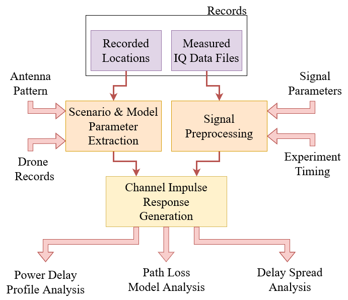
The post-processing analysis flow diagram is shown in Fig. 3. First of all, undesired recordings outside the measurement time interval are removed and the measured IQ data are frequency aligned in the signal pre-processing block. Furthermore, in the scenario and model parameter extraction block, the recorded location information is utilized to obtain the azimuth and elevation angles between TX-D and RX-D. Using the antenna pattern information together with the azimuth and elevation angles, the effects of the antenna patterns are normalized to the omnidirectional pattern. This normalization removes the effects of the antenna on the received signal so that only the channel effects are retained. Then, the losses due to the antenna patterns are calculated and sent to the CIR generation block which removes these losses on the received signal.
The received signal includes at least 9 periods of the PN–sequence for each measurement which holds the 81900 samples of IQ data. Since the frequency synchronization between TX-D and RX-D is provided by GPSDO during the experiments, coherent correlations can be directly performed in the CIR generation block. A coherent auto-correlation between the raw data and the known transmitted sequence is calculated to extract the CIR from the raw data. Note that the known transmitted sequence is successively repeated to increase the correlation gain. For example, the correlation gain is 36 dB, 42 dB, and 45 dB when the number of repeated known transmitted sequences is 1, 4, and 8, respectively and it is set to 8 unless otherwise specified. The CIR contains direct path component (DPC), multipath components (MPC), and noise components. The power threshold, which is used to decide whether an MPC is strong or weak, is set to dB below the DPC power [14, 15]. And the components that are below the power threshold are excluded from the CIR.
IV Measurement Results & Discussions


After the CIR is generated in Fig. 3, it can be utilized to obtain important channel characteristics such as path loss model, power delay profile, and delay spread. In this section, the measurement results of these characteristics are presented for A2A and A2G scenarios.
Fig. 4 shows the path loss results of the measurement, fit line, FSPL and FE2R models for the A2G scenario. The path loss measurement values are directly calculated from the CIR values corresponding to various distances between TX-D and RX-D. The reference distance is 1 meter. The fit line results are calculated by fitting the measurement values into the log-distance path loss model defined in (3), where the and are calculated as 1.934 and 41.320, respectively. The FE2R model in [16] is used as a reference since it has been heavily utilized in the literature. The measurement results have a similar trend compared to FE2R such that path losses increase with respect to the distance. Since FE2R represents an ideal environment where there is only a single reflection which causes significant increases in PL when the phase of the reflected signal is opposite of the phase of the direct-path signal. However, the measurement environment consists of many reflection sources generating different phases and therefore a single phase of a reflection source does not have a significant impact on PL as much as FE2R.
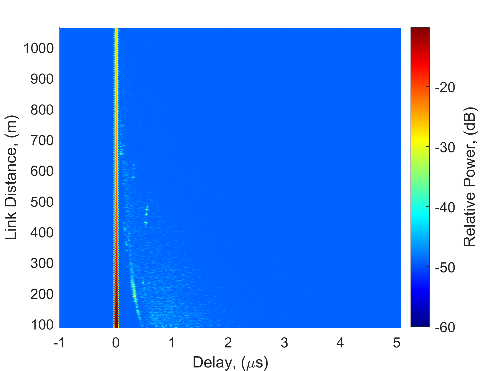
Fig. 4 shows the path loss results of the measurement, fit line, FSPL and FE2R models for the A2A scenario. For the fit line results, the and are calculated as 2.166 and 34.650, respectively. Similar to the A2G, the measured PL values for A2A increases with respect to distance. The variation of the measured PL values is relatively lower for A2A since the scatterers are far from the drones; hence, their effects on the PL values are limited. This observation is also supported by the measured PDP results in Fig. 6, where DPC is visually distinguishable from the ground reflection and their power strengths are lower for the A2A.


| A2G | A2A | |||
| (dB) | ||||
| (ns) | Mean | 10.983 | 9.884 | |
|
||||
| Median | ||||
| Min | ||||
| Max |
Fig. 5 shows RMS-DS () results for both A2G and A2A, where values are mostly lower than 20 ns and 50 ns for A2A and A2G, respectively. However, sudden peaks are observed for when the distance is between 300-400 m and 400-500 m for A2G and A2A, respectively. These peaks are due to either a strong reflection from a near source or a weak reflection from a distant source as predicted by (4). There are several buildings having metal roofs and claddings on the measurement site. These structures cause the reflections resulting in sudden peaks in the RMS-DS. Note that can be up to 144 ns for A2A while it is up to 291 ns for A2G. The statistics of are summarized in Table II.
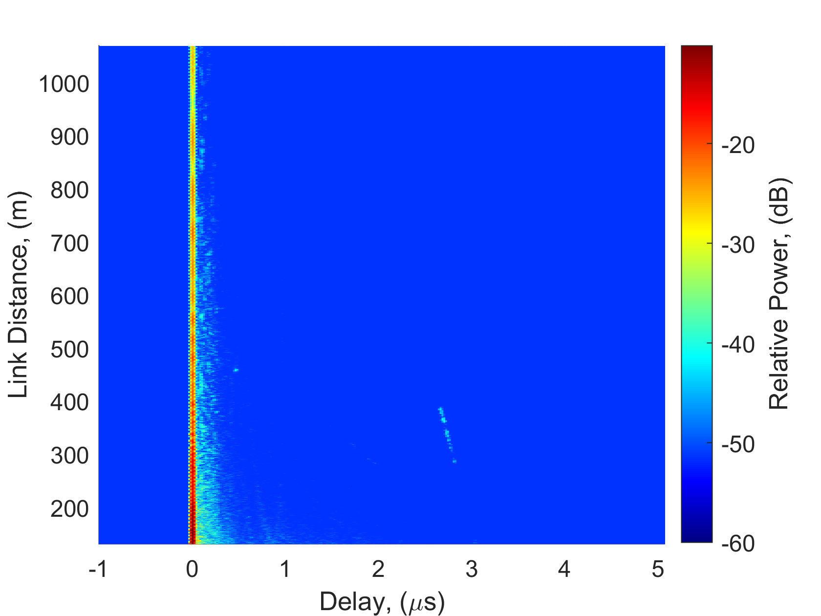
The measured PDPs for A2A and A2G are shown in Figure 6 and 6, respectively. For the A2A scenario, the MPC due to the main ground reflection is visually distinguishable when the distance between the drones is close. As TX-D moves away, the time delay between the MPC and the DPC decreases as expected. The other reflections from the forested terrain smoothly fade as depicted in Fig. 6. The dominant reflections in the figure are likely caused by the buildings having metal roofs and claddings as explained above. The time delay between DPC and MPCs mostly lies between 0 and 300 ns for A2G while it is widely spread between 0 and 2 s for A2A. However, the power of the MPCs is significantly higher for A2G resulting in higher RMS-DS. The time delay of the MPCs causing the sudden peaks in RMS-DS as depicted in Fig. 5 can be visually seen in Fig. 6.
V Conclusion
In this paper, we presented field measurement-based channel characterization for A2G and A2A wireless communication systems using two drones hosting lightweight SDR. A sounding waveform with a PN sequence is sent by the transmitting drone and the receiving drone captures the sounding waveform to extract several channel characteristics such as path loss, RMS-DS, and multipath delays. The path loss results for the measurement and FE2R show similar trends for A2G while the measurement and FSPL are similar for A2A. The multipath delays create more challenging channel conditions for A2G under a similar mobility scenario. Extensive measurements will be made with the sounder in different environments and waveform parameters for future work.
Acknowledgment
We thank to StorAIge project that has received funding from the KDT Joint Undertaking (JU) under Grant Agreement No. 101007321. The JU receives support from the European Union’s Horizon 2020 research and innovation programme in France, Belgium, Czech Republic, Germany, Italy, Sweden, Switzerland, Türkiye, and National Authority TÜBİTAK with project ID 121N350.
References
- [1] H. Shakhatreh and et al., “Unmanned Aerial Vehicles (UAVs): A survey on civil applications and key research challenges,” IEEE Access, vol. 7, pp. 48 572–48 634, 2019.
- [2] Y. Zeng, Q. Wu, and R. Zhang, “Accessing from the sky: A tutorial on UAV communications for 5G and beyond,” Proceedings of the IEEE, vol. 107, no. 12, pp. 2327–2375, 2019.
- [3] M. Mozaffari, W. Saad, M. Bennis, Y.-H. Nam, and M. Debbah, “A tutorial on UAVs for wireless networks: Applications, challenges, and open problems,” IEEE Communications Surveys & Tutorials, vol. 21, no. 3, pp. 2334–2360, 2019.
- [4] D. W. Matolak and U.-C. Fiebig, “UAV Channel Models: Review and Future Research,” in 2019 13th European Conference on Antennas and Propagation (EuCAP), 2019, pp. 1–5.
- [5] W. Khawaja, I. Guvenc, D. W. Matolak, U.-C. Fiebig, and N. Schneckenburger, “A Survey of Air-to-Ground Propagation Channel Modeling for Unmanned Aerial Vehicles,” IEEE Communications Surveys & Tutorials, vol. 21, no. 3, pp. 2361–2391, 2019.
- [6] R. Amorim, H. Nguyen, P. Mogensen, I. Z. Kovács, J. Wigard, and T. B. Sørensen, “Radio Channel Modeling for UAV Communication Over Cellular Networks,” IEEE Wireless Communications Letters, vol. 6, no. 4, pp. 514–517, 2017.
- [7] M. Badi, D. Rajan, and J. Camp, “Measurement-based Characterization of Human Body Impact on Ultra-low UAV-to-Ground Channels,” in MILCOM 2021 - 2021 IEEE Military Communications Conference (MILCOM), 2021, pp. 556–561.
- [8] N. Stofik, D. W. Matolak, and A. Sahin, “Measurement and Modeling of Low-Altitude Air-Ground Channels in Two Frequency Bands,” in 2022 Integrated Communication, Navigation and Surveillance Conference (ICNS), 2022, pp. 1–10.
- [9] D. Becker and U.-C. Fiebig, “Measurement Based Identification of MPCs in an Urban Drone-to-Drone Propagation Scenario,” in 2022 16th European Conference on Antennas and Propagation (EuCAP), 2022, pp. 1–5.
- [10] D. Becker, U.-C. Fiebig, and L. Schalk, “Wideband Channel Measurements and First Findings for Low Altitude Drone-to-Drone Links in an Urban Scenario,” in 2020 14th European Conference on Antennas and Propagation (EuCAP), 2020, pp. 1–5.
- [11] Z. Guan and T. Kulkarni, “On the Effects of Mobility Uncertainties on Wireless Communications between Flying Drones in the mmWave/THz Bands,” in IEEE INFOCOM 2019 - IEEE Conference on Computer Communications Workshops (INFOCOM WKSHPS), 2019, pp. 768–773.
- [12] A. Yılmaz and C. Toker, “Air-to-Air Channel Model for UAV Communications,” in 2022 30th Signal Processing and Communications Applications Conference (SIU), 2022, pp. 1–4.
- [13] R. J. Pirkl and G. D. Durgin, “Optimal sliding correlator channel sounder design,” IEEE Trans. Wireless Commun., vol. 7, no. 9, pp. 3488–3497, 2008.
- [14] Recommendations. ITU-R, “Multipath propagation and parameterization of its characteristics,” Recommendation P.1407-8, 2019. [Online]. Available: tinyurl.com/3ny6c8ur
- [15] S. Ju, Y. Xing, O. Kanhere, and T. S. Rappaport, “Sub-Terahertz Channel Measurements and Characterization in a Factory Building,” in IEEE International Conference on Communications, 2022, pp. 2882–2887.
- [16] J. D. Parsons, “The Mobile Radio Propagation Channel,” Nov 2001. [Online]. Available: http://dx.doi.org/10.1002/0470841524